https://www.kgis.org/kgismaps/map.htm? Subdivision: Alt_NaWind Song Apts (Historical) Northwest Cou 3
https://www.kgis.org/kgismaps/map.htm? Subdivision: Alt_NaWoodmead South (Historical) South City SOUTH KNOXVILLE 9 1
https://www.kgis.org/kgismaps/map.htm? Subdivision: Alt_NaZaina Apts (Historical) South City 9 1
Attraction:Amusementhttps://www.kgis.org/kgismaps/map.htm? POIAdventure Action Park Southwest Cou CEDAR BLUFF 3 2Kingston Pike (9305) aka: Veloce Indoor Speedway
(historical)
https://www.kgis.org/kgismaps/map.htm? POI: Alt_NameVeloce Indoor Speedway (historical) Southwest Cou CEDAR BLUFF 3 2Kingston Pike (9305) aka: Adventure Action Park
Attraction:Exhibit / Conference Venuehttps://www.kgis.org/kgismaps/map.htm? POI: Alt_NameGateway Center (historical) Central City DOWNTOWN 1 6Volunteer Landing Ln (900) aka: Outdoor
Adventure Ctr
https://www.kgis.org/kgismaps/map.htm? POI: Long_NameJackson Avenue Terminal Central City OLD CITY 1 6W Jackson Ave (205) aka: Southern Railroad Terminal (historical)
https://www.kgis.org/kgismaps/map.htm? POIJackson Terminal Central City OLD CITY 1 6W Jackson Ave (205) aka: Southern Railroad Terminal (historical)
https://www.kgis.org/kgismaps/map.htm? POIOutdoor Adventure Ctr Central City DOWNTOWN 1 6Volunteer Landing Ln (900) aka: Gateway Center (historical)
https://www.kgis.org/kgismaps/map.htm? POI: Long_NameOutdoor Knoxville Adventure Center Central City DOWNTOWN 1 6Volunteer Landing Ln (900) aka: Gateway Center (historical)
https://www.kgis.org/kgismaps/map.htm? POI: Alt_NameSouthern Railroad Terminal (historical) Central City OLD CITY 1 6W Jackson Ave (205) aka: Jackson Terminal
Attraction:Historichttps://www.kgis.org/kgismaps/map.htm? POI: Long_NameFort Byington Site Central City UNIVERSITY OF TENNESSE 9 1Circle Dr (1413) aka: Ft Byington Civil War Site
(historical)
https://www.kgis.org/kgismaps/map.htm? POI: Long_NameFort Dickerson Site South City SOUTH KNOXVILLE 9 1Fort Dickerson Rd (3000) aka: Ft Dickerson Civil War Site (historical)
https://www.kgis.org/kgismaps/map.htm? POI: Long_NameFort Higley Site South City 9 1Cherokee Trl (800) aka: Ft Higley Civil War Site (historical)
https://www.kgis.org/kgismaps/map.htm? POI: Long_NameFort Hill site South City OLD SEVIER 9 1Knotty Pine Way (1231) aka: Ft Hill Civil War Site (historical)
https://www.kgis.org/kgismaps/map.htm? POI: Long_NameFort Sanders Site Central City FORT SANDERS 1 1S Seventeenth St (505) aka: Ft Sanders Civil War Site (historical)
https://www.kgis.org/kgismaps/map.htm? POI: Long_NameFort Stanley Site South City GOBBLERS KNOB 9 1Sherrod Rd (2501) aka: Ft Stanley Civil War Site (historical)
https://www.kgis.org/kgismaps/map.htm? POI: Alt_NameFt Byington Civil War Site (historical) Central City UNIVERSITY OF TENNESSE 9 1Circle Dr (1413) aka: Ft Byington
https://www.kgis.org/kgismaps/map.htm? POI: Alt_NameFt Dickerson Civil War Site (historical) South City SOUTH KNOXVILLE 9 1Fort Dickerson Rd (3000) aka: Ft Dickerson
https://www.kgis.org/kgismaps/map.htm? POI: Alt_NameFt Higley Civil War Site (historical) South City 9 1Cherokee Trl (800) aka: Ft Higley
https://www.kgis.org/kgismaps/map.htm? POI: Alt_NameFt Hill Civil War Site (historical) South City OLD SEVIER 9 1Knotty Pine Way (1231) aka: Ft Hill
https://www.kgis.org/kgismaps/map.htm? POI: Alt_NameFt Sanders Civil War Site (historical) Central City FORT SANDERS 1 1S Seventeenth St (505) aka: Ft Sanders
https://www.kgis.org/kgismaps/map.htm? POI: Alt_NameFt Stanley Civil War Site (historical) South City GOBBLERS KNOB 9 1Sherrod Rd (2501) aka: Ft Stanley
Buildinghttps://www.kgis.org/kgismaps/map.htm? POIBlount Hall Central City UNIVERSITY OF TENNESSE 9 1White Ave (1500) aka: White Avenue Building
(historical)
https://www.kgis.org/kgismaps/map.htm? POI: Alt_NameCampbell Station Inn (historical) Southwest Cou CAMPBELL STATION 5Kingston Pike (11409) aka: Martin - Russell House
https://www.kgis.org/kgismaps/map.htm? POIElliott Bldg Central City DOWNTOWN 1 6W Church Ave (207) aka: Whitefield Apartments Building (historical)
https://www.kgis.org/kgismaps/map.htm? POIGen Neyland House Central City UNIVERSITY OF TENNESSE 9 1Terrace Ave (2111) aka: Robert Briscoe House (historical)
https://www.kgis.org/kgismaps/map.htm? POI: Long_NameGeneral Robert Neyland House Central City UNIVERSITY OF TENNESSE 9 1Terrace Ave (2111) aka: Robert Briscoe House (historical)
https://www.kgis.org/kgismaps/map.htm? POIGlenmary House Southwest Cou 5Westland Dr (8800) aka: Maple Grove Inn (historical)
Historical (Retired) Feature / Place Name Planning Sector Feature Typ
CategoryCommunity / District
City County Neighborhoodhttps://www.kgis.org/kgismaps/map.htm? POI: Alt_NameHouse of Brown (historical) Central City SOUTH MARKET HISTORIC 1 6W Church Ave (314) aka: Pryor Brown Bldg
https://www.kgis.org/kgismaps/map.htm? POI: Alt_NameKUB Building (historical) Central City DOWNTOWN 1 6S Gay St (620) aka: Tombras Bldg
https://www.kgis.org/kgismaps/map.htm? POILakeshore Admin Bldg West City LYONS VIEW 4 2Lyons View Pike (6040) aka: Lakeshore Mental Hospital Administration Building (historical)
https://www.kgis.org/kgismaps/map.htm? POI: Long_NameLakeshore Administrative Building West City LYONS VIEW 4 2Lyons View Pike (6040) aka: Lakeshore Mental Hospital Administration Building (historical)
https://www.kgis.org/kgismaps/map.htm? POI: Alt_NameLakeshore Mental Hospital Administration Building (historical)
West City LYONS VIEW 4 2Lyons View Pike (6040) aka: Lakeshore Admin Bldg
https://www.kgis.org/kgismaps/map.htm? POI: Alt_NameLawson McGhee Library (historical) Central City DOWNTOWN 1 6S Gay St (128) aka: Rebori Bldg
https://www.kgis.org/kgismaps/map.htm? POI: Alt_NameMaple Grove Inn (historical) Southwest Cou 5Westland Dr (8800) aka: Glenmary House
https://www.kgis.org/kgismaps/map.htm? POIMartin - Russell House Southwest Cou CAMPBELL STATION 5Kingston Pike (11409) aka: Campbell Station Inn (historical)
https://www.kgis.org/kgismaps/map.htm? POI: Alt_NameMary Reed Apts (historical) Central City SEQUOYAH HILLS 4 2Kingston Pike (3051) aka: Nicholas Bldg
https://www.kgis.org/kgismaps/map.htm? POIMast General Bldg Central City DOWNTOWN 1 6S Gay St (402) aka: McNulty Grocery Dry Goods Bldg (historical)
https://www.kgis.org/kgismaps/map.htm? POI: Long_NameMast General Store Building Central City DOWNTOWN 1 6S Gay St (402) aka: McNulty Grocery Dry Goods Bldg (historical)
https://www.kgis.org/kgismaps/map.htm? POI: Alt_NameMcNulty Grocery Dry Goods Bldg (historical) Central City DOWNTOWN 1 6S Gay St (402) aka: Mast General Bldg
https://www.kgis.org/kgismaps/map.htm? POINicholas Bldg Central City SEQUOYAH HILLS 4 2Kingston Pike (3051) aka: Mary Reed Apts (historical)
https://www.kgis.org/kgismaps/map.htm? POIOld South High South City SOUTH KNOXVILLE 9 1E Moody Ave (953) aka: South High School (historical)
https://www.kgis.org/kgismaps/map.htm? POI: Long_NameOld South Knoxville High School Building South City SOUTH KNOXVILLE 9 1E Moody Ave (953) aka: South High School (historical)
https://www.kgis.org/kgismaps/map.htm? POI: Long_NameOld State Supreme Court Building Central City DOWNTOWN 1 6Cumberland Ave (617) aka: Tennessee Attorney General Office (historical)
https://www.kgis.org/kgismaps/map.htm? POIPryor Brown Bldg Central City SOUTH MARKET HISTORIC 1 6W Church Ave (314) aka: House of Brown (historical)
https://www.kgis.org/kgismaps/map.htm? POI: Long_NamePryor Brown Garage Building Central City SOUTH MARKET HISTORIC 1 6W Church Ave (314) aka: House of Brown (historical)
https://www.kgis.org/kgismaps/map.htm? POIRebori Bldg Central City DOWNTOWN 1 6S Gay St (128) aka: Lawson McGhee Library (historical)
https://www.kgis.org/kgismaps/map.htm? POI: Long_NameRebori Building Central City DOWNTOWN 1 6S Gay St (128) aka: Lawson McGhee Library (historical)
https://www.kgis.org/kgismaps/map.htm? POI: Alt_NameRobert Briscoe House (historical) Central City UNIVERSITY OF TENNESSE 9 1Terrace Ave (2111) aka: Gen Neyland House
https://www.kgis.org/kgismaps/map.htm? POI: Long_NameSamuel Martin - Avery Russell House Southwest Cou CAMPBELL STATION 5Kingston Pike (11409) aka: Campbell Station Inn (historical)
https://www.kgis.org/kgismaps/map.htm? POI: Alt_NameSouth High School (historical) South City SOUTH KNOXVILLE 9 1E Moody Ave (953) aka: Old South High
https://www.kgis.org/kgismaps/map.htm? POIState Supreme Court Bldg Central City DOWNTOWN 1 6Cumberland Ave (617) aka: Tennessee Attorney General Office (historical)
https://www.kgis.org/kgismaps/map.htm? POI: Alt_NameTennessee Attorney General Office (historical)
Central City DOWNTOWN 1 6Cumberland Ave (617) aka: State Supreme Court Bldg
https://www.kgis.org/kgismaps/map.htm? POI: Long_NameThe Elliot Hotel Building Central City DOWNTOWN 1 6W Church Ave (207) aka: Whitefield Apartments Building (historical)
https://www.kgis.org/kgismaps/map.htm? POI: Long_NameThe Nicholas Building Central City SEQUOYAH HILLS 4 2Kingston Pike (3051) aka: Mary Reed Apts (historical)
https://www.kgis.org/kgismaps/map.htm? POITombras Bldg Central City DOWNTOWN 1 6S Gay St (620) aka: KUB Building (historical)
https://www.kgis.org/kgismaps/map.htm? POI: Long_NameTombras Building Central City DOWNTOWN 1 6S Gay St (620) aka: KUB Building (historical)
https://www.kgis.org/kgismaps/map.htm? POI: Alt_NameTyson Jr High School (historical) Central City 1 6Kingston Pike (2607) aka: Tyson Place
https://www.kgis.org/kgismaps/map.htm? POITyson Place Central City 1 6Kingston Pike (2607) aka: Tyson Jr High School (historical)
https://www.kgis.org/kgismaps/map.htm? POI: Long_NameUT Blount Hall Central City UNIVERSITY OF TENNESSE 9 1White Ave (1500) aka: White Avenue Building (historical)
https://www.kgis.org/kgismaps/map.htm? POI: Alt_NameWhite Avenue Building (historical) Central City UNIVERSITY OF TENNESSE 9 1White Ave (1500) aka: Blount Hall
https://www.kgis.org/kgismaps/map.htm? POI: Alt_NameWhitefield Apartments Building (historical) Central City DOWNTOWN 1 6W Church Ave (207) aka: Elliott Bldg
Cemeteryhttps://www.kgis.org/kgismaps/map.htm? POI: Alt_NameAdair Creek Baptist Church Cemetery (historical)
North City SMITHWOOD 2 4Jacksboro Pike (4916) aka: Smithwood Baptist Cem
https://www.kgis.org/kgismaps/map.htm? POIArmstrong Cem II (historical) East City 1 4George Bounds Rd (205)
https://www.kgis.org/kgismaps/map.htm? POI: Long_NameArmstrong Cemetery II (historical) East City 1 4George Bounds Rd (205)
https://www.kgis.org/kgismaps/map.htm? POI: Alt_NameBeaver Dam Baptist Church Cemetery (historical)
North County HALLS 7Andersonville Pike (7426) aka: Mynatt Cem II
https://www.kgis.org/kgismaps/map.htm? POI: Alt_NameBird Family Cemetery (historical) Northwest Cou 6Lamons Quarry Ln (1550) aka: Ruckport Cem
Historical (Retired) Feature / Place Name Planning Sector Feature Typ
CategoryCommunity / District
City County Neighborhoodhttps://www.kgis.org/kgismaps/map.htm? POICentral Baptist Bearden Cem West City BEARDEN 4 2Deane Hill Dr (6302) aka: Erin Presbyterian
Cemetery (historical); Cooper Cemetery (historical)
https://www.kgis.org/kgismaps/map.htm? POI: Long_NameCentral Baptist Church of Bearden Cemetery West City BEARDEN 4 2Deane Hill Dr (6302) aka: Erin Presbyterian Cemetery (historical); Cooper Cemetery (historical)
https://www.kgis.org/kgismaps/map.htm? POI: Alt_NameDempsey Johnson Family Cemetery (historical)
South City 9 1Island Home Ave (3130) aka: Stanton Cem
https://www.kgis.org/kgismaps/map.htm? POI: Long_NameElm Grove Cemetery North City FOUNTAIN CITY 2 4Jacksboro Pike (5023) aka: Northern Methodist Episcopal Church Cemetery (historical)
https://www.kgis.org/kgismaps/map.htm? POI: Alt_NameErin Presbyterian Cemetery (historical); Cooper Cemetery (historical)
West City BEARDEN 4 2Deane Hill Dr (6302) aka: Central Baptist Bearden Cem
https://www.kgis.org/kgismaps/map.htm? POI: Alt_NameFlenniken Family Cemetery (historical) South County VESTAL 9 1Walter Reed Ln (1350) aka: Walter Reed Cem (historical)
https://www.kgis.org/kgismaps/map.htm? POI: Long_NameGlenwood Baptist Church Cemetery North County POWELL 7Central Avenue Pike (7212) aka: Wood Family Cemetery (historical)
https://www.kgis.org/kgismaps/map.htm? POIGlenwood Cem North County POWELL 7Central Avenue Pike (7212) aka: Wood Family Cemetery (historical)
https://www.kgis.org/kgismaps/map.htm? POI: Long_NameGood Samaritan Cemetery Central City FIVE POINTS 1 6Bethel Ave (2001) aka: Mt Calvary Lodge Cemetery (historical)
https://www.kgis.org/kgismaps/map.htm? POI: Long_NameMcCall Cemetery South City LAKE FOREST 9 1Centerwood Dr (6009) aka: New Prospect Presbyterian Church (historical)
https://www.kgis.org/kgismaps/map.htm? POI: Alt_NameMt Calvary Lodge Cemetery (historical) Central City FIVE POINTS 1 6Bethel Ave (2001) aka: Good Samaritan Cem
https://www.kgis.org/kgismaps/map.htm? POIMynatt Cem II North County HALLS 7Andersonville Pike (7426) aka: Beaver Dam Baptist Church Cemetery (historical)
https://www.kgis.org/kgismaps/map.htm? POI: Long_NameMynatt Cemetery II North County HALLS 7Andersonville Pike (7426) aka: Beaver Dam Baptist Church Cemetery (historical)
https://www.kgis.org/kgismaps/map.htm? POI: Alt_NameNew Prospect Presbyterian Church (historical)
South City LAKE FOREST 9 1Centerwood Dr (6009) aka: McCall Cem
https://www.kgis.org/kgismaps/map.htm? POI: Alt_NameNorthern Methodist Episcopal Church Cemetery (historical)
North City FOUNTAIN CITY 2 4Jacksboro Pike (5023) aka: Elm Grove Cem
https://www.kgis.org/kgismaps/map.htm? POI: Alt_NamePossum Valley Cemetery (historical) Southwest Cou SHADY GROVE 5S Northshore Dr (12870) aka: Shady Grove Cem
https://www.kgis.org/kgismaps/map.htm? POIRidgeway Baptist Cem South County SEVEN ISLANDS 9Kimberlin Heights Rd (3515) aka: Ridgeway Methodist Church Cemetery (historical)
https://www.kgis.org/kgismaps/map.htm? POI: Long_NameRidgeway Baptist Church Cemetery South County SEVEN ISLANDS 9Kimberlin Heights Rd (3515) aka: Ridgeway Methodist Church Cemetery (historical)
https://www.kgis.org/kgismaps/map.htm? POI: Alt_NameRidgeway Methodist Church Cemetery (historical)
South County SEVEN ISLANDS 9Kimberlin Heights Rd (3515) aka: Ridgeway Baptist Cem
https://www.kgis.org/kgismaps/map.htm? POI: Long_NameShady Grove Baptist Church Cemetery Southwest Cou SHADY GROVE 5S Northshore Dr (12870) aka: Possum Valley Cemetery (historical)
https://www.kgis.org/kgismaps/map.htm? POIShady Grove Cem Southwest Cou SHADY GROVE 5S Northshore Dr (12870) aka: Possum Valley Cemetery (historical)
https://www.kgis.org/kgismaps/map.htm? POISmithwood Baptist Cem North City SMITHWOOD 2 4Jacksboro Pike (4916) aka: Adair Creek Baptist Church Cemetery (historical)
https://www.kgis.org/kgismaps/map.htm? POI: Long_NameSmithwood Baptist Church Cemetery North City SMITHWOOD 2 4Jacksboro Pike (4916) aka: Adair Creek Baptist Church Cemetery (historical)
https://www.kgis.org/kgismaps/map.htm? POI: Long_NameStanton Cemetery South City 9 1Island Home Ave (3130) aka: Dempsey Johnson Family Cemetery (historical)
https://www.kgis.org/kgismaps/map.htm? POITwinville Baptist Cem North County 8E Raccoon Valley Dr (4123) aka: Twinville Methodist Church Cemetery (historical)
https://www.kgis.org/kgismaps/map.htm? POI: Long_NameTwinville Baptist Church Cemetery North County 8E Raccoon Valley Dr (4123) aka: Twinville Methodist Church Cemetery (historical)
https://www.kgis.org/kgismaps/map.htm? POI: Alt_NameTwinville Methodist Church Cemetery (historical)
North County 8E Raccoon Valley Dr (4123) aka: Twinville Baptist Cem
https://www.kgis.org/kgismaps/map.htm? POIWalter Reed Cem (historical) South County VESTAL 9 1Walter Reed Ln (1350) aka: Flenniken Family Cemetery (historical)
https://www.kgis.org/kgismaps/map.htm? POI: Long_NameWalter Reed Cemetery (historical) South County VESTAL 9 1Walter Reed Ln (1350) aka: Flenniken Family Cemetery (historical)
https://www.kgis.org/kgismaps/map.htm? POI: Alt_NameWood Family Cemetery (historical) North County POWELL 7Central Avenue Pike (7212) aka: Glenwood Cem
Commercial:Shopping Centerhttps://www.kgis.org/kgismaps/map.htm? POI: Alt_NameFive Points Village (historical) East City FIVE POINTS 1 6Martin Luther King Jr Ave (2364) aka: Harvest Place
https://www.kgis.org/kgismaps/map.htm? POIHarvest Place East City FIVE POINTS 1 6Martin Luther King Jr Ave (2364) aka: Five Points Village (historical)
Historical (Retired) Feature / Place Name Planning Sector Feature Typ
CategoryCommunity / District
City County Neighborhoodhttps://www.kgis.org/kgismaps/map.htm? POI: Long_NameBearden Branch Library West City DEANE HILL 4 2Golfclub Rd (100) aka: West Knoxville Branch
Library (historical)
https://www.kgis.org/kgismaps/map.htm? POIBearden Lib West City DEANE HILL 4 2Golfclub Rd (100) aka: West Knoxville Branch Library (historical)
https://www.kgis.org/kgismaps/map.htm? POI: Alt_NameWest Knoxville Branch Library (historical) West City DEANE HILL 4 2Golfclub Rd (100) aka: Bearden Lib
Community Service:Otherhttps://www.kgis.org/kgismaps/map.htm? POI: Alt_NameAbbey Fields Urban Farm (historical) Central City MAGNOLIA WAREHOUSE 1 6Washington Ave (1400) aka: BattleField Gardens
https://www.kgis.org/kgismaps/map.htm? POI: Long_NameBattleField Farm and Gardens Central City MAGNOLIA WAREHOUSE 1 6Washington Ave (1400) aka: Abbey Fields Urban Farm (historical)
https://www.kgis.org/kgismaps/map.htm? POIBattleField Gardens Central City MAGNOLIA WAREHOUSE 1 6Washington Ave (1400) aka: Abbey Fields Urban Farm (historical)
https://www.kgis.org/kgismaps/map.htm? POI: Alt_NameChild & Family Services (Haslam Academy) (historical)
Northwest Cou 3 3Lake Brook Blvd (3006) aka: Helen Ross McNabb (Lake Brook)
https://www.kgis.org/kgismaps/map.htm? POI: Alt_NameCold Springs Farm (historical) East City PARK CITY 1 6Martin Luther King Jr Ave (2619) aka: KARM Serenity House
https://www.kgis.org/kgismaps/map.htm? POIKARM Serenity House East City PARK CITY 1 6Martin Luther King Jr Ave (2619) aka: Cold Springs Farm (historical)
https://www.kgis.org/kgismaps/map.htm? POI: Long_NameKnox Area Rescue Ministries Serenity House East City PARK CITY 1 6Martin Luther King Jr Ave (2619) aka: Cold Springs Farm (historical)
Condohttps://www.kgis.org/kgismaps/map.htm? Subdivision: Alt_NaBroadway Court Condos (Historical) East City NORTH KNOXVILLE 2 4
https://www.kgis.org/kgismaps/map.htm? Subdivision: Alt_NaGovernors Landing (Historical) East County 8
https://www.kgis.org/kgismaps/map.htm? Subdivision: Alt_NaGrand Oaks Condos (Historical) North City INSKIP 2 5
https://www.kgis.org/kgismaps/map.htm? Subdivision: Alt_NaMary Reed Apts (Historical) Central City SEQUOYAH HILLS 4 2
https://www.kgis.org/kgismaps/map.htm? Subdivision: Alt_NaRichmond Heights Condos (Historical) Central City 1 3
https://www.kgis.org/kgismaps/map.htm? Subdivision: Alt_NaThe Commons On Bridge (Historical) Central City FORT SANDERS 1 1
Emergency:Fire Facilityhttps://www.kgis.org/kgismaps/map.htm? POIKFD Arson Central City OAKWOOD 2 5E Caldwell Ave (336) aka: KFD Fire Station 8
(historical)
https://www.kgis.org/kgismaps/map.htm? POI: Alt_NameKFD Fire Station 8 (historical) Central City OAKWOOD 2 5E Caldwell Ave (336) aka: KFD Arson
https://www.kgis.org/kgismaps/map.htm? POI: Long_NameKnoxville Fire Department Arson Investigation
Central City OAKWOOD 2 5E Caldwell Ave (336) aka: KFD Fire Station 8 (historical)
Government:Facilityhttps://www.kgis.org/kgismaps/map.htm? POI: Alt_NameCamp John Sevier WW1 POW Camp (historical)
North County HALLS 7 4Rifle Range Rd (2327) aka: TWRA Hunter Education Ctr
https://www.kgis.org/kgismaps/map.htm? POI: Long_NameJohn Sevier Hunter Education Center (TWRA)
North County HALLS 7 4Rifle Range Rd (2327) aka: Camp John Sevier WW1 POW Camp (historical)
https://www.kgis.org/kgismaps/map.htm? POITWRA Hunter Education Ctr North County HALLS 7 4Rifle Range Rd (2327) aka: Camp John Sevier WW1 POW Camp (historical)
Health Service:Assisted Livinghttps://www.kgis.org/kgismaps/map.htm? POI: Long_NameBeverly Park Place Health and Rehab Center North City 2Beverly Park Cir (5321) aka: Hillcrest North
Nursing Home (historical)
https://www.kgis.org/kgismaps/map.htm? POI: Alt_NameHillcrest North Nursing Home (historical) North City 2Beverly Park Cir (5321) aka: Beverly Park Place
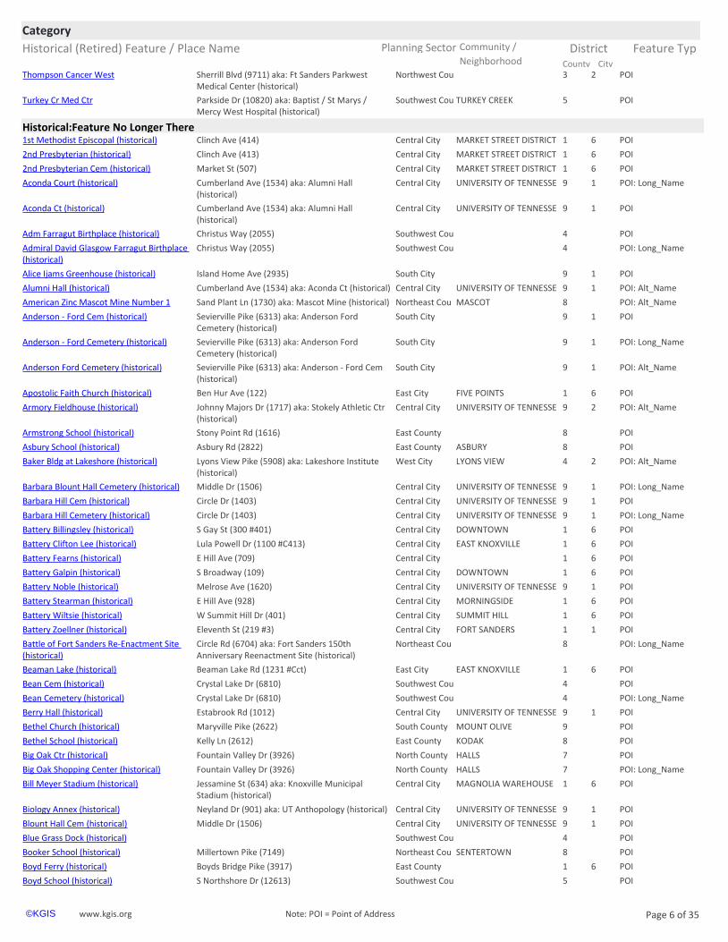
Health Service:Hospitalhttps://www.kgis.org/kgismaps/map.htm? POI: Alt_NameBaptist / St Marys / Mercy West Hospital (historical)
Southwest Cou TURKEY CREEK 5Parkside Dr (10820) aka: Turkey Cr Med Ctr
https://www.kgis.org/kgismaps/map.htm? POI: Alt_NameFt Sanders Parkwest Medical Center (historical)
Northwest Cou 3 2Sherrill Blvd (9711) aka: Thompson Cancer West
https://www.kgis.org/kgismaps/map.htm? POIN Knoxville Med Ctr North County POWELL 7Dannaher Dr (7551) aka: St Marys / Mercy North Hospital (historical)
https://www.kgis.org/kgismaps/map.htm? POI: Alt_NameSt Marys / Mercy North Hospital (historical) North County POWELL 7Dannaher Dr (7551) aka: N Knoxville Med Ctr
https://www.kgis.org/kgismaps/map.htm? POI: Long_NameTennova North Knoxville Medical Center North County POWELL 7Dannaher Dr (7551) aka: St Marys / Mercy North Hospital (historical)
https://www.kgis.org/kgismaps/map.htm? POI: Long_NameTennova Turkey Creek Medical Center Southwest Cou TURKEY CREEK 5Parkside Dr (10820) aka: Baptist / St Marys / Mercy West Hospital (historical)
https://www.kgis.org/kgismaps/map.htm? POI: Long_NameThompson Cancer Survival Center West Northwest Cou 3 2Sherrill Blvd (9711) aka: Ft Sanders Parkwest Medical Center (historical)
Historical (Retired) Feature / Place Name Planning Sector Feature Typ
CategoryCommunity / District
City County Neighborhoodhttps://www.kgis.org/kgismaps/map.htm? POIThompson Cancer West Northwest Cou 3 2Sherrill Blvd (9711) aka: Ft Sanders Parkwest
Medical Center (historical)
https://www.kgis.org/kgismaps/map.htm? POITurkey Cr Med Ctr Southwest Cou TURKEY CREEK 5Parkside Dr (10820) aka: Baptist / St Marys / Mercy West Hospital (historical)
Historical:Feature No Longer Therehttps://www.kgis.org/kgismaps/map.htm? POI1st Methodist Episcopal (historical) Central City MARKET STREET DISTRICT 1 6Clinch Ave (414)
https://www.kgis.org/kgismaps/map.htm? POI2nd Presbyterian (historical) Central City MARKET STREET DISTRICT 1 6Clinch Ave (413)
https://www.kgis.org/kgismaps/map.htm? POI2nd Presbyterian Cem (historical) Central City MARKET STREET DISTRICT 1 6Market St (507)
https://www.kgis.org/kgismaps/map.htm? POI: Long_NameAconda Court (historical) Central City UNIVERSITY OF TENNESSE 9 1Cumberland Ave (1534) aka: Alumni Hall (historical)
https://www.kgis.org/kgismaps/map.htm? POIAconda Ct (historical) Central City UNIVERSITY OF TENNESSE 9 1Cumberland Ave (1534) aka: Alumni Hall (historical)
https://www.kgis.org/kgismaps/map.htm? POIAdm Farragut Birthplace (historical) Southwest Cou 4Christus Way (2055)
https://www.kgis.org/kgismaps/map.htm? POI: Long_NameAdmiral David Glasgow Farragut Birthplace (historical)
Southwest Cou 4Christus Way (2055)
https://www.kgis.org/kgismaps/map.htm? POIAlice Ijams Greenhouse (historical) South City 9 1Island Home Ave (2935)
https://www.kgis.org/kgismaps/map.htm? POI: Alt_NameAlumni Hall (historical) Central City UNIVERSITY OF TENNESSE 9 1Cumberland Ave (1534) aka: Aconda Ct (historical)
https://www.kgis.org/kgismaps/map.htm? POIAnderson - Ford Cem (historical) South City 9 1Sevierville Pike (6313) aka: Anderson Ford Cemetery (historical)
https://www.kgis.org/kgismaps/map.htm? POI: Long_NameAnderson - Ford Cemetery (historical) South City 9 1Sevierville Pike (6313) aka: Anderson Ford Cemetery (historical)
https://www.kgis.org/kgismaps/map.htm? POI: Alt_NameAnderson Ford Cemetery (historical) South City 9 1Sevierville Pike (6313) aka: Anderson - Ford Cem (historical)
https://www.kgis.org/kgismaps/map.htm? POIApostolic Faith Church (historical) East City FIVE POINTS 1 6Ben Hur Ave (122)
https://www.kgis.org/kgismaps/map.htm? POI: Alt_NameArmory Fieldhouse (historical) Central City UNIVERSITY OF TENNESSE 9 2Johnny Majors Dr (1717) aka: Stokely Athletic Ctr (historical)
https://www.kgis.org/kgismaps/map.htm? POIArmstrong School (historical) East County 8Stony Point Rd (1616)
https://www.kgis.org/kgismaps/map.htm? POIAsbury School (historical) East County ASBURY 8Asbury Rd (2822)
https://www.kgis.org/kgismaps/map.htm? POI: Alt_NameBaker Bldg at Lakeshore (historical) West City LYONS VIEW 4 2Lyons View Pike (5908) aka: Lakeshore Institute (historical)
https://www.kgis.org/kgismaps/map.htm? POI: Long_NameBarbara Blount Hall Cemetery (historical) Central City UNIVERSITY OF TENNESSE 9 1Middle Dr (1506)
https://www.kgis.org/kgismaps/map.htm? POIBarbara Hill Cem (historical) Central City UNIVERSITY OF TENNESSE 9 1Circle Dr (1403)
https://www.kgis.org/kgismaps/map.htm? POI: Long_NameBarbara Hill Cemetery (historical) Central City UNIVERSITY OF TENNESSE 9 1Circle Dr (1403)
https://www.kgis.org/kgismaps/map.htm? POIBattery Billingsley (historical) Central City DOWNTOWN 1 6S Gay St (300 #401)
https://www.kgis.org/kgismaps/map.htm? POIBattery Clifton Lee (historical) Central City EAST KNOXVILLE 1 6Lula Powell Dr (1100 #C413)
https://www.kgis.org/kgismaps/map.htm? POIBattery Fearns (historical) Central City 1 6E Hill Ave (709)
https://www.kgis.org/kgismaps/map.htm? POIBattery Galpin (historical) Central City DOWNTOWN 1 6S Broadway (109)
https://www.kgis.org/kgismaps/map.htm? POIBattery Noble (historical) Central City UNIVERSITY OF TENNESSE 9 1Melrose Ave (1620)
https://www.kgis.org/kgismaps/map.htm? POIBattery Stearman (historical) Central City MORNINGSIDE 1 6E Hill Ave (928)
https://www.kgis.org/kgismaps/map.htm? POIBattery Wiltsie (historical) Central City SUMMIT HILL 1 6W Summit Hill Dr (401)
https://www.kgis.org/kgismaps/map.htm? POIBattery Zoellner (historical) Central City FORT SANDERS 1 1Eleventh St (219 #3)
https://www.kgis.org/kgismaps/map.htm? POI: Long_NameBattle of Fort Sanders Re-Enactment Site (historical)
Northeast Cou 8Circle Rd (6704) aka: Fort Sanders 150th Anniversary Reenactment Site (historical)
https://www.kgis.org/kgismaps/map.htm? POIBeaman Lake (historical) East City EAST KNOXVILLE 1 6Beaman Lake Rd (1231 #Cct)
https://www.kgis.org/kgismaps/map.htm? POIBean Cem (historical) Southwest Cou 4Crystal Lake Dr (6810)
https://www.kgis.org/kgismaps/map.htm? POI: Long_NameBean Cemetery (historical) Southwest Cou 4Crystal Lake Dr (6810)
https://www.kgis.org/kgismaps/map.htm? POIBerry Hall (historical) Central City UNIVERSITY OF TENNESSE 9 1Estabrook Rd (1012)
https://www.kgis.org/kgismaps/map.htm? POIBethel Church (historical) South County MOUNT OLIVE 9Maryville Pike (2622)
https://www.kgis.org/kgismaps/map.htm? POIBethel School (historical) East County KODAK 8Kelly Ln (2612)
https://www.kgis.org/kgismaps/map.htm? POIBig Oak Ctr (historical) North County HALLS 7Fountain Valley Dr (3926)
https://www.kgis.org/kgismaps/map.htm? POI: Long_NameBig Oak Shopping Center (historical) North County HALLS 7Fountain Valley Dr (3926)
https://www.kgis.org/kgismaps/map.htm? POIBill Meyer Stadium (historical) Central City MAGNOLIA WAREHOUSE 1 6Jessamine St (634) aka: Knoxville Municipal Stadium (historical)
https://www.kgis.org/kgismaps/map.htm? POIBiology Annex (historical) Central City UNIVERSITY OF TENNESSE 9 1Neyland Dr (901) aka: UT Anthopology (historical)
https://www.kgis.org/kgismaps/map.htm? POIBlount Hall Cem (historical) Central City UNIVERSITY OF TENNESSE 9 1Middle Dr (1506)
https://www.kgis.org/kgismaps/map.htm? POIBlue Grass Dock (historical) Southwest Cou 4
https://www.kgis.org/kgismaps/map.htm? POIBooker School (historical) Northeast Cou SENTERTOWN 8Millertown Pike (7149)
https://www.kgis.org/kgismaps/map.htm? POIBoyd Ferry (historical) East County 1 6Boyds Bridge Pike (3917)
https://www.kgis.org/kgismaps/map.htm? POIBoyd School (historical) Southwest Cou 5S Northshore Dr (12613)
Historical (Retired) Feature / Place Name Planning Sector Feature Typ
CategoryCommunity / District
City County Neighborhoodhttps://www.kgis.org/kgismaps/map.htm? POI: Alt_NameBrakebill Indian Mound at Gilliams Station (historical)
East County FORKS OF THE RIVER 8Asbury Rd (2403) aka: Brakebill's Mound (historical)
https://www.kgis.org/kgismaps/map.htm? POI: Long_NameBrakebills Indian Mound (historical) East County FORKS OF THE RIVER 8Asbury Rd (2403) aka: Brakebill Indian Mound at Gilliams Station (historical)
https://www.kgis.org/kgismaps/map.htm? POIBrakebill's Mound (historical) East County FORKS OF THE RIVER 8Asbury Rd (2403) aka: Brakebill Indian Mound at Gilliams Station (historical)
https://www.kgis.org/kgismaps/map.htm? POIBranch Hill Church (historical) Northwest Cou 6George Light Rd (3055)
https://www.kgis.org/kgismaps/map.htm? POIBrewers Park (historical) East City PARK CITY 1 6Selma Ave (2637)
https://www.kgis.org/kgismaps/map.htm? POIBroadway Speedway (historical) North County HALLS 7Fountain Valley Dr (3902)
https://www.kgis.org/kgismaps/map.htm? POIBrooks Road Church (historical) East City EAST KNOXVILLE 1 6Brooks Ave (3320)
https://www.kgis.org/kgismaps/map.htm? POIBrookside Mills (historical) Central City 1 6W Baxter Ave (545)
https://www.kgis.org/kgismaps/map.htm? POI: Alt_NameBurke Bridge (historical) East County 8 4Asheville Hwy (6110) aka: James Edward Burke Bridge (historical)
https://www.kgis.org/kgismaps/map.htm? POICabbage Cem (historical) North County HALLS 7Miracle Ln (4208)
https://www.kgis.org/kgismaps/map.htm? POI: Long_NameCabbage Cemetery (historical) North County HALLS 7Miracle Ln (4208)
https://www.kgis.org/kgismaps/map.htm? POI: Alt_NameCal Johnson Racetrack (historical) East City BURLINGTON 1 6Speedway Cir (3790) aka: Cal Johnson Speedway (historical)
https://www.kgis.org/kgismaps/map.htm? POICal Johnson Speedway (historical) East City BURLINGTON 1 6Speedway Cir (3790) aka: Cal Johnson Racetrack (historical)
https://www.kgis.org/kgismaps/map.htm? POICallahan Cem (historical) North City DANTE 7Kern Rd (6601) aka: Tillery Cemetery (historical)
https://www.kgis.org/kgismaps/map.htm? POI: Long_NameCallahan Cemetery (historical) North City DANTE 7Kern Rd (6601) aka: Tillery Cemetery (historical)
https://www.kgis.org/kgismaps/map.htm? POICallans Pond (historical) East County TUCKAHOE 8 4Midway Rd (1211)
https://www.kgis.org/kgismaps/map.htm? POICalloway Island (historical) Southwest Cou 5
https://www.kgis.org/kgismaps/map.htm? POI: Long_NameCarolyn P Brown University Center (historical)
Central City UNIVERSITY OF TENNESSE 9 1Cumberland Ave (1502)
https://www.kgis.org/kgismaps/map.htm? POICarpenter School (historical) Northwest Cou 6Carpenter Rd (7324)
https://www.kgis.org/kgismaps/map.htm? POICarter Mill (historical) East County CARTER 8Carter Mill Dr (9218)
https://www.kgis.org/kgismaps/map.htm? POICaswell Taylor House (historical) Central City FOURTH & GILL 2 4N Fourth Ave (803) aka: The Governors House (historical)
https://www.kgis.org/kgismaps/map.htm? POICausier School (historical) Central City MECHANICSVILLE 1 6Reynolds St (1719)
https://www.kgis.org/kgismaps/map.htm? POICCC Camp 495 (historical) North County POWELL STATION 7
https://www.kgis.org/kgismaps/map.htm? POICedar Cliff Church (historical) Southwest Cou WEST KNOXVILLE 3 2Kingston Pike (8870)
https://www.kgis.org/kgismaps/map.htm? POICedar Grove School (historical) Northwest Cou 3 3Middlebrook Pike (5937)
https://www.kgis.org/kgismaps/map.htm? POI: Alt_NameChair Rock at Luttrell Park South City SOUTH WATERFRONT 9 1E Blount Ave (151) aka: Luttrell Park (historical)
https://www.kgis.org/kgismaps/map.htm? POIChandler Lake (historical) Northwest Cou 6Schaad Rd (3301)
https://www.kgis.org/kgismaps/map.htm? POIChestnut Grove School (historical) Northwest Cou 6Yarnell Rd (10911)
https://www.kgis.org/kgismaps/map.htm? POIChildress Cem (historical) North County PEDIGO 7Long Hollow Rd (2709)
https://www.kgis.org/kgismaps/map.htm? POI: Long_NameChildress Cemetery (historical) North County PEDIGO 7Long Hollow Rd (2709)
https://www.kgis.org/kgismaps/map.htm? POIChota Bldg (historical) West City LYONS VIEW 4 2S Northshore Dr (6400)
https://www.kgis.org/kgismaps/map.htm? POI: Long_NameChota Building at Lakeshore (historical) West City LYONS VIEW 4 2S Northshore Dr (6400)
https://www.kgis.org/kgismaps/map.htm? POIChrist Temple Apostolic (historical) Central City LONSDALE 1 5Minnesota Ave (1900)
https://www.kgis.org/kgismaps/map.htm? POI: Long_NameChrist Temple Apostolic Church (historical) Central City LONSDALE 1 5Minnesota Ave (1900)
https://www.kgis.org/kgismaps/map.htm? POIChristenberry Jr High (historical) Central City 2 5Oglewood Ave (927)
https://www.kgis.org/kgismaps/map.htm? POI: Long_NameChristenberry Junior High School (historical) Central City 2 5Oglewood Ave (927)
https://www.kgis.org/kgismaps/map.htm? POIChristian Fellowship (Andrew Johnson Hwy) (historical)
East County TRENTVILLE 8Andrew Johnson Hwy (309)
https://www.kgis.org/kgismaps/map.htm? POI: Long_NameChristian Fellowship Church on Andrew Johnson Hwy (historical)
East County TRENTVILLE 8Andrew Johnson Hwy (309)
https://www.kgis.org/kgismaps/map.htm? POI: Long_NameCivilian Conservation Corps Camp Number 495 (historical)
North County POWELL STATION 7
https://www.kgis.org/kgismaps/map.htm? POIClaiborne Cem (historical) North City FOUNTAIN CITY 2 4Tazewell Pike (4008)
https://www.kgis.org/kgismaps/map.htm? POI: Long_NameClaiborne Cemetery (historical) North City FOUNTAIN CITY 2 4Tazewell Pike (4008)
https://www.kgis.org/kgismaps/map.htm? POIClark Cem (historical) North County 8Old Maynardville Pike (9202)
https://www.kgis.org/kgismaps/map.htm? POI: Long_NameClark Cemetery (historical) North County 8Old Maynardville Pike (9202)
https://www.kgis.org/kgismaps/map.htm? POIClaxton Church (historical) North County 7Naff Rd (9436)
https://www.kgis.org/kgismaps/map.htm? POIClinch Avenue Park (historical) Central City UNIVERSITY OF TENNESSE 9 2Volunteer Blvd (1800)
https://www.kgis.org/kgismaps/map.htm? POICline Cem (historical) North County 8Old Maynardville Pike (8320)
https://www.kgis.org/kgismaps/map.htm? POI: Long_NameCline Cemetery (historical) North County 8Old Maynardville Pike (8320)
Historical (Retired) Feature / Place Name Planning Sector Feature Typ
CategoryCommunity / District
City County Neighborhoodhttps://www.kgis.org/kgismaps/map.htm? POIColored Cem (historical) East County 8Drummer Ln (545) aka: Coloured Cemetery
(historical)
https://www.kgis.org/kgismaps/map.htm? POI: Long_NameColored Cemetery (historical) East County 8Drummer Ln (545) aka: Coloured Cemetery (historical)
https://www.kgis.org/kgismaps/map.htm? POI: Alt_NameColoured Cemetery (historical) East County 8Drummer Ln (545) aka: Colored Cem (historical)
https://www.kgis.org/kgismaps/map.htm? POIConcord School (historical) Southwest Cou CONCORD 5Loop Rd (709)
https://www.kgis.org/kgismaps/map.htm? POI: Long_NameCormac McCarthy Homeplace (historical) South County 9W Martin Mill Pike (5501) aka: Cormac McCarthy House (historical)
https://www.kgis.org/kgismaps/map.htm? POI: Alt_NameCormac McCarthy House (historical) South County 9W Martin Mill Pike (5501) aka: McCarthy Homeplace (historical)
https://www.kgis.org/kgismaps/map.htm? POICorum Cem (historical) Northwest Cou 6Pinestraw Ln (1811)
https://www.kgis.org/kgismaps/map.htm? POI: Alt_NameDaniel McCall Cemetery (historical) North County HALLS 7Kingdom Ln (4215) aka: McCall Cem II (historical)
https://www.kgis.org/kgismaps/map.htm? POIDante Dale School (historical) North County 7Dantedale Rd (6715)
https://www.kgis.org/kgismaps/map.htm? POIDante School (historical) North City DANTE 7Dante School Rd (422)
https://www.kgis.org/kgismaps/map.htm? POI: Alt_NameDeane Hill Country Club West City DEANE HILL 4 2Catherine Mcauley Way (401) aka: The Deanery (historical)
https://www.kgis.org/kgismaps/map.htm? POI: Long_NameDepartment of Health Building at Lakeshore (historical)
West City LYONS VIEW 4 2Lyons View Pike (5908)
https://www.kgis.org/kgismaps/map.htm? POIDept of Health Bldg (historical) West City LYONS VIEW 4 2Lyons View Pike (5908)
https://www.kgis.org/kgismaps/map.htm? POI: Long_NameDr Lee L Williams Senior Center (historical) Central City FIVE POINTS 1 6Martin Luther King Jr Ave (2240) aka: Dr Lee Williams Complex (historical)
https://www.kgis.org/kgismaps/map.htm? POI: Alt_NameDr Lee Williams Complex (historical) Central City FIVE POINTS 1 6Martin Luther King Jr Ave (2240) aka: Williams Senior Ctr (historical)
https://www.kgis.org/kgismaps/map.htm? POIE Hill Ave Cem (historical) Central City 1 6E Hill Ave (501) aka: E Hill Ave Cemetery (historical)
https://www.kgis.org/kgismaps/map.htm? POI: Alt_NameE Hill Ave Cemetery (historical) Central City 1 6E Hill Ave (501) aka: E Hill Ave Cem (historical)
https://www.kgis.org/kgismaps/map.htm? POIEarley Island (historical) Southwest Cou 5
https://www.kgis.org/kgismaps/map.htm? POIEast Emory Church (historical) Southwest Cou 4Bluegrass Rd (9806)
https://www.kgis.org/kgismaps/map.htm? POIEast Emory School (historical) Southwest Cou 4Whistler Woods Way (1611)
https://www.kgis.org/kgismaps/map.htm? POI: Long_NameEast Hill Avenue Methodist Church Cemetery (historical)
Central City 1 6E Hill Ave (501) aka: E Hill Ave Cemetery (historical)
https://www.kgis.org/kgismaps/map.htm? POIEast Stony Point School (historical) East County 8Mccarty Rd (1735)
https://www.kgis.org/kgismaps/map.htm? POIEleanor Mill (historical) North County 7E Raccoon Valley Dr (1707)
https://www.kgis.org/kgismaps/map.htm? POIElmwood School (historical) Northeast Cou 8Millertown Pike (5912)
https://www.kgis.org/kgismaps/map.htm? POIEstabrook Hall (historical) Central City UNIVERSITY OF TENNESSE 9 1Estabrook Rd (1012)
https://www.kgis.org/kgismaps/map.htm? POIEvans - Collins Field (historical) Central City EAST KNOXVILLE 1 6Winona St (620)
https://www.kgis.org/kgismaps/map.htm? POIFaith & Hope Baptist (historical) South County 9Kimberlin Heights Rd (122) aka: Faith and Hope Baptist Church (historical)
https://www.kgis.org/kgismaps/map.htm? POI: Long_NameFaith & Hope Baptist Church (historical) South County 9Kimberlin Heights Rd (122) aka: Faith and Hope Baptist Church (historical)
https://www.kgis.org/kgismaps/map.htm? POI: Alt_NameFaith and Hope Baptist Church (historical) South County 9Kimberlin Heights Rd (122) aka: Faith & Hope Baptist (historical)
https://www.kgis.org/kgismaps/map.htm? POI: Long_NameFaith Christian Center (historical) East City EAST KNOXVILLE 1 6Skyline Dr (3536)
https://www.kgis.org/kgismaps/map.htm? POIFaith Christian Ctr (historical) East City EAST KNOXVILLE 1 6Skyline Dr (3536)
https://www.kgis.org/kgismaps/map.htm? POI: Long_NameFaith Presbyterian Church (historical) Southwest Cou BLUEGRASS 4 2Pinnacle Pointe Way (1992)
https://www.kgis.org/kgismaps/map.htm? POI: Long_NameFirst Methodist Episcopal Church (historical) Central City MARKET STREET DISTRICT 1 6Clinch Ave (414)
https://www.kgis.org/kgismaps/map.htm? POIFlenniken Cem (historical) Southwest Cou RIVERBEND 4Lyons Bend Rd (2127) aka: Tarwater - Flenniken II Cemetery (historical)
https://www.kgis.org/kgismaps/map.htm? POI: Long_NameFlenniken Cemetery (historical) Southwest Cou RIVERBEND 4Lyons Bend Rd (2127) aka: Tarwater - Flenniken II Cemetery (historical)
https://www.kgis.org/kgismaps/map.htm? POIFletcher Cem (historical) North County 71120 (E Bullrun Valley Dr)
https://www.kgis.org/kgismaps/map.htm? POI: Long_NameFletcher Cemetery (historical) North County 71120 (E Bullrun Valley Dr)
https://www.kgis.org/kgismaps/map.htm? POIForestdale Brethren Cem (historical) East City NORTH KNOXVILLE 2 4Brunswick St (3118) aka: Forestdale Methodist Cemetery (historical)
https://www.kgis.org/kgismaps/map.htm? POI: Alt_NameForestdale Methodist Cemetery (historical) East City NORTH KNOXVILLE 2 4Brunswick St (3118) aka: Forestdale Brethren Cem (historical)
Historical (Retired) Feature / Place Name Planning Sector Feature Typ
CategoryCommunity / District
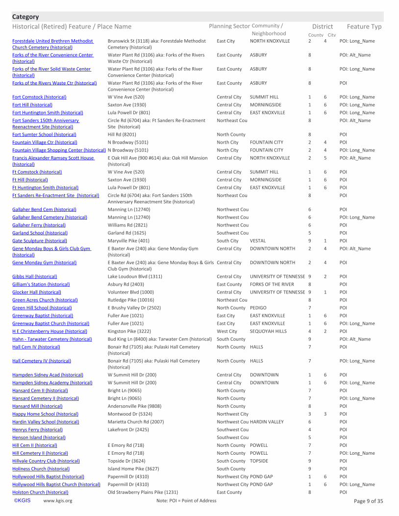
City County Neighborhoodhttps://www.kgis.org/kgismaps/map.htm? POI: Long_NameForestdale United Brethren Methodist Church Cemetery (historical)
East City NORTH KNOXVILLE 2 4Brunswick St (3118) aka: Forestdale Methodist Cemetery (historical)
https://www.kgis.org/kgismaps/map.htm? POI: Alt_NameForks of the River Convenience Center (historical)
East County ASBURY 8Water Plant Rd (3106) aka: Forks of the Rivers Waste Ctr (historical)
https://www.kgis.org/kgismaps/map.htm? POI: Long_NameForks of the River Solid Waste Center (historical)
East County ASBURY 8Water Plant Rd (3106) aka: Forks of the River Convenience Center (historical)
https://www.kgis.org/kgismaps/map.htm? POIForks of the Rivers Waste Ctr (historical) East County ASBURY 8Water Plant Rd (3106) aka: Forks of the River Convenience Center (historical)
https://www.kgis.org/kgismaps/map.htm? POI: Long_NameFort Comstock (historical) Central City SUMMIT HILL 1 6W Vine Ave (520)
https://www.kgis.org/kgismaps/map.htm? POI: Long_NameFort Hill (historical) Central City MORNINGSIDE 1 6Saxton Ave (1930)
https://www.kgis.org/kgismaps/map.htm? POI: Long_NameFort Huntington Smith (historical) Central City EAST KNOXVILLE 1 6Lula Powell Dr (801)
https://www.kgis.org/kgismaps/map.htm? POI: Alt_NameFort Sanders 150th Anniversary Reenactment Site (historical)
Northeast Cou 8Circle Rd (6704) aka: Ft Sanders Re-Enactment Site (historical)
https://www.kgis.org/kgismaps/map.htm? POIFort Sumter School (historical) North County 8Hill Rd (8201)
https://www.kgis.org/kgismaps/map.htm? POIFountain Village Ctr (historical) North City FOUNTAIN CITY 2 4N Broadway (5101)
https://www.kgis.org/kgismaps/map.htm? POI: Long_NameFountain Village Shopping Center (historical) North City FOUNTAIN CITY 2 4N Broadway (5101)
https://www.kgis.org/kgismaps/map.htm? POI: Alt_NameFrancis Alexander Ramsey Scott House (historical)
Central City NORTH KNOXVILLE 2 5E Oak Hill Ave (900 #614) aka: Oak Hill Mansion (historical)
https://www.kgis.org/kgismaps/map.htm? POIFt Comstock (historical) Central City SUMMIT HILL 1 6W Vine Ave (520)
https://www.kgis.org/kgismaps/map.htm? POIFt Hill (historical) Central City MORNINGSIDE 1 6Saxton Ave (1930)
https://www.kgis.org/kgismaps/map.htm? POIFt Huntington Smith (historical) Central City EAST KNOXVILLE 1 6Lula Powell Dr (801)
https://www.kgis.org/kgismaps/map.htm? POIFt Sanders Re-Enactment Site (historical) Northeast Cou 8Circle Rd (6704) aka: Fort Sanders 150th Anniversary Reenactment Site (historical)
https://www.kgis.org/kgismaps/map.htm? POIGallaher Bend Cem (historical) Northwest Cou 6Manning Ln (12740)
https://www.kgis.org/kgismaps/map.htm? POIGarland School (historical) Southwest Cou 5Garland Rd (1625)
https://www.kgis.org/kgismaps/map.htm? POIGate Sculpture (historical) South City VESTAL 9 1Maryville Pike (401)
https://www.kgis.org/kgismaps/map.htm? POI: Alt_NameGene Monday Boys & Girls Club Gym (historical)
Central City DOWNTOWN NORTH 2 4E Baxter Ave (240) aka: Gene Monday Gym (historical)
https://www.kgis.org/kgismaps/map.htm? POIGene Monday Gym (historical) Central City DOWNTOWN NORTH 2 4E Baxter Ave (240) aka: Gene Monday Boys & Girls Club Gym (historical)
https://www.kgis.org/kgismaps/map.htm? POIGibbs Hall (historical) Central City UNIVERSITY OF TENNESSE 9 2Lake Loudoun Blvd (1311)
https://www.kgis.org/kgismaps/map.htm? POIGilliam's Station (historical) East County FORKS OF THE RIVER 8Asbury Rd (2403)
https://www.kgis.org/kgismaps/map.htm? POIGlocker Hall (historical) Central City UNIVERSITY OF TENNESSE 9 1Volunteer Blvd (1000)
https://www.kgis.org/kgismaps/map.htm? POIGreen Acres Church (historical) Northeast Cou 8Rutledge Pike (10016)
https://www.kgis.org/kgismaps/map.htm? POIGreen Hill School (historical) North County PEDIGO 7E Brushy Valley Dr (2502)
https://www.kgis.org/kgismaps/map.htm? POIGreenway Baptist (historical) East City EAST KNOXVILLE 1 6Fuller Ave (1021)
https://www.kgis.org/kgismaps/map.htm? POI: Long_NameGreenway Baptist Church (historical) East City EAST KNOXVILLE 1 6Fuller Ave (1021)
https://www.kgis.org/kgismaps/map.htm? POIH E Christenberry House (historical) West City SEQUOYAH HILLS 4 2Kingston Pike (3222)
https://www.kgis.org/kgismaps/map.htm? POI: Alt_NameHahn - Tarwater Cemetery (historical) South County 9Bud King Ln (8400) aka: Tarwater Cem (historical)
https://www.kgis.org/kgismaps/map.htm? POIHall Cem IV (historical) North County HALLS 7Bonair Rd (7105) aka: Pulaski Hall Cemetery (historical)
https://www.kgis.org/kgismaps/map.htm? POI: Long_NameHall Cemetery IV (historical) North County HALLS 7Bonair Rd (7105) aka: Pulaski Hall Cemetery (historical)
https://www.kgis.org/kgismaps/map.htm? POIHampden Sidney Acad (historical) Central City DOWNTOWN 1 6W Summit Hill Dr (200)
https://www.kgis.org/kgismaps/map.htm? POI: Long_NameHampden Sidney Academy (historical) Central City DOWNTOWN 1 6W Summit Hill Dr (200)
https://www.kgis.org/kgismaps/map.htm? POIHansard Cem II (historical) North County 7Bright Ln (9065)
https://www.kgis.org/kgismaps/map.htm? POI: Long_NameHansard Cemetery II (historical) North County 7Bright Ln (9065)
https://www.kgis.org/kgismaps/map.htm? POIHansard Mill (historical) North County 8Andersonville Pike (9808)
https://www.kgis.org/kgismaps/map.htm? POIHappy Home School (historical) Northwest City 3 3Montwood Dr (5324)
https://www.kgis.org/kgismaps/map.htm? POIHardin Valley School (historical) Northwest Cou HARDIN VALLEY 6Marietta Church Rd (2007)
https://www.kgis.org/kgismaps/map.htm? POIHenrys Ferry (historical) Southwest Cou 4Lakefront Dr (2425)
https://www.kgis.org/kgismaps/map.htm? POIHenson Island (historical) Southwest Cou 5
https://www.kgis.org/kgismaps/map.htm? POIHill Cem II (historical) North County POWELL 7E Emory Rd (718)
https://www.kgis.org/kgismaps/map.htm? POI: Long_NameHill Cemetery II (historical) North County POWELL 7E Emory Rd (718)
https://www.kgis.org/kgismaps/map.htm? POIHillvale Country Club (historical) South County TOPSIDE 9Topside Dr (3624)
https://www.kgis.org/kgismaps/map.htm? POIHoliness Church (historical) South County 9Island Home Pike (3627)
https://www.kgis.org/kgismaps/map.htm? POIHollywood Hills Baptist (historical) Northwest City POND GAP 1 6Papermill Dr (4310)
https://www.kgis.org/kgismaps/map.htm? POI: Long_NameHollywood Hills Baptist Church (historical) Northwest City POND GAP 1 6Papermill Dr (4310)
https://www.kgis.org/kgismaps/map.htm? POIHolston Church (historical) East County 8Old Strawberry Plains Pike (1231)
Historical (Retired) Feature / Place Name Planning Sector Feature Typ
CategoryCommunity / District
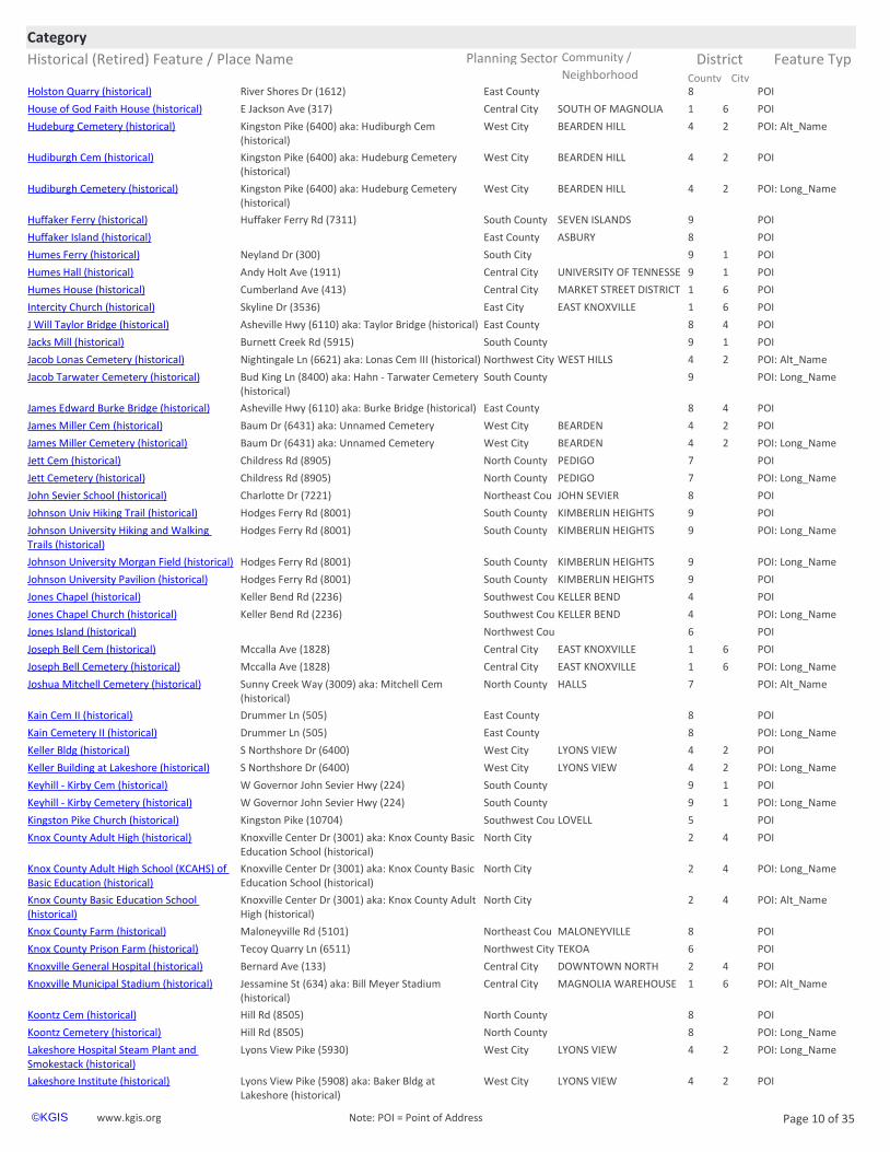
City County Neighborhoodhttps://www.kgis.org/kgismaps/map.htm? POIHolston Quarry (historical) East County 8River Shores Dr (1612)
https://www.kgis.org/kgismaps/map.htm? POIHouse of God Faith House (historical) Central City SOUTH OF MAGNOLIA 1 6E Jackson Ave (317)
https://www.kgis.org/kgismaps/map.htm? POI: Alt_NameHudeburg Cemetery (historical) West City BEARDEN HILL 4 2Kingston Pike (6400) aka: Hudiburgh Cem (historical)
https://www.kgis.org/kgismaps/map.htm? POIHudiburgh Cem (historical) West City BEARDEN HILL 4 2Kingston Pike (6400) aka: Hudeburg Cemetery (historical)
https://www.kgis.org/kgismaps/map.htm? POI: Long_NameHudiburgh Cemetery (historical) West City BEARDEN HILL 4 2Kingston Pike (6400) aka: Hudeburg Cemetery (historical)
https://www.kgis.org/kgismaps/map.htm? POIHuffaker Ferry (historical) South County SEVEN ISLANDS 9Huffaker Ferry Rd (7311)
https://www.kgis.org/kgismaps/map.htm? POIHuffaker Island (historical) East County ASBURY 8
https://www.kgis.org/kgismaps/map.htm? POIHumes Ferry (historical) South City 9 1Neyland Dr (300)
https://www.kgis.org/kgismaps/map.htm? POIHumes Hall (historical) Central City UNIVERSITY OF TENNESSE 9 1Andy Holt Ave (1911)
https://www.kgis.org/kgismaps/map.htm? POIHumes House (historical) Central City MARKET STREET DISTRICT 1 6Cumberland Ave (413)
https://www.kgis.org/kgismaps/map.htm? POIIntercity Church (historical) East City EAST KNOXVILLE 1 6Skyline Dr (3536)
https://www.kgis.org/kgismaps/map.htm? POIJ Will Taylor Bridge (historical) East County 8 4Asheville Hwy (6110) aka: Taylor Bridge (historical)
https://www.kgis.org/kgismaps/map.htm? POIJacks Mill (historical) South County 9 1Burnett Creek Rd (5915)
https://www.kgis.org/kgismaps/map.htm? POI: Alt_NameJacob Lonas Cemetery (historical) Northwest City WEST HILLS 4 2Nightingale Ln (6621) aka: Lonas Cem III (historical)
https://www.kgis.org/kgismaps/map.htm? POI: Long_NameJacob Tarwater Cemetery (historical) South County 9Bud King Ln (8400) aka: Hahn - Tarwater Cemetery (historical)
https://www.kgis.org/kgismaps/map.htm? POIJames Edward Burke Bridge (historical) East County 8 4Asheville Hwy (6110) aka: Burke Bridge (historical)
https://www.kgis.org/kgismaps/map.htm? POIJames Miller Cem (historical) West City BEARDEN 4 2Baum Dr (6431) aka: Unnamed Cemetery
https://www.kgis.org/kgismaps/map.htm? POI: Long_NameJames Miller Cemetery (historical) West City BEARDEN 4 2Baum Dr (6431) aka: Unnamed Cemetery
https://www.kgis.org/kgismaps/map.htm? POIJett Cem (historical) North County PEDIGO 7Childress Rd (8905)
https://www.kgis.org/kgismaps/map.htm? POI: Long_NameJett Cemetery (historical) North County PEDIGO 7Childress Rd (8905)
https://www.kgis.org/kgismaps/map.htm? POIJohn Sevier School (historical) Northeast Cou JOHN SEVIER 8Charlotte Dr (7221)
https://www.kgis.org/kgismaps/map.htm? POIJohnson Univ Hiking Trail (historical) South County KIMBERLIN HEIGHTS 9Hodges Ferry Rd (8001)
https://www.kgis.org/kgismaps/map.htm? POI: Long_NameJohnson University Hiking and Walking Trails (historical)
South County KIMBERLIN HEIGHTS 9Hodges Ferry Rd (8001)
https://www.kgis.org/kgismaps/map.htm? POI: Long_NameJohnson University Morgan Field (historical) South County KIMBERLIN HEIGHTS 9Hodges Ferry Rd (8001)
https://www.kgis.org/kgismaps/map.htm? POIJohnson University Pavilion (historical) South County KIMBERLIN HEIGHTS 9Hodges Ferry Rd (8001)
https://www.kgis.org/kgismaps/map.htm? POIJones Chapel (historical) Southwest Cou KELLER BEND 4Keller Bend Rd (2236)
https://www.kgis.org/kgismaps/map.htm? POI: Long_NameJones Chapel Church (historical) Southwest Cou KELLER BEND 4Keller Bend Rd (2236)
https://www.kgis.org/kgismaps/map.htm? POIJones Island (historical) Northwest Cou 6
https://www.kgis.org/kgismaps/map.htm? POIJoseph Bell Cem (historical) Central City EAST KNOXVILLE 1 6Mccalla Ave (1828)
https://www.kgis.org/kgismaps/map.htm? POI: Long_NameJoseph Bell Cemetery (historical) Central City EAST KNOXVILLE 1 6Mccalla Ave (1828)
https://www.kgis.org/kgismaps/map.htm? POI: Alt_NameJoshua Mitchell Cemetery (historical) North County HALLS 7Sunny Creek Way (3009) aka: Mitchell Cem (historical)
https://www.kgis.org/kgismaps/map.htm? POIKain Cem II (historical) East County 8Drummer Ln (505)
https://www.kgis.org/kgismaps/map.htm? POI: Long_NameKain Cemetery II (historical) East County 8Drummer Ln (505)
https://www.kgis.org/kgismaps/map.htm? POIKeller Bldg (historical) West City LYONS VIEW 4 2S Northshore Dr (6400)
https://www.kgis.org/kgismaps/map.htm? POI: Long_NameKeller Building at Lakeshore (historical) West City LYONS VIEW 4 2S Northshore Dr (6400)
https://www.kgis.org/kgismaps/map.htm? POIKeyhill - Kirby Cem (historical) South County 9 1W Governor John Sevier Hwy (224)
https://www.kgis.org/kgismaps/map.htm? POI: Long_NameKeyhill - Kirby Cemetery (historical) South County 9 1W Governor John Sevier Hwy (224)
https://www.kgis.org/kgismaps/map.htm? POIKnox County Adult High (historical) North City 2 4Knoxville Center Dr (3001) aka: Knox County Basic Education School (historical)
https://www.kgis.org/kgismaps/map.htm? POI: Long_NameKnox County Adult High School (KCAHS) of Basic Education (historical)
North City 2 4Knoxville Center Dr (3001) aka: Knox County Basic Education School (historical)
https://www.kgis.org/kgismaps/map.htm? POI: Alt_NameKnox County Basic Education School (historical)
North City 2 4Knoxville Center Dr (3001) aka: Knox County Adult High (historical)
https://www.kgis.org/kgismaps/map.htm? POIKnox County Prison Farm (historical) Northwest City TEKOA 6Tecoy Quarry Ln (6511)
https://www.kgis.org/kgismaps/map.htm? POIKnoxville General Hospital (historical) Central City DOWNTOWN NORTH 2 4Bernard Ave (133)
https://www.kgis.org/kgismaps/map.htm? POI: Alt_NameKnoxville Municipal Stadium (historical) Central City MAGNOLIA WAREHOUSE 1 6Jessamine St (634) aka: Bill Meyer Stadium (historical)
https://www.kgis.org/kgismaps/map.htm? POIKoontz Cem (historical) North County 8Hill Rd (8505)
https://www.kgis.org/kgismaps/map.htm? POI: Long_NameKoontz Cemetery (historical) North County 8Hill Rd (8505)
https://www.kgis.org/kgismaps/map.htm? POI: Long_NameLakeshore Hospital Steam Plant and Smokestack (historical)
West City LYONS VIEW 4 2Lyons View Pike (5930)
https://www.kgis.org/kgismaps/map.htm? POILakeshore Institute (historical) West City LYONS VIEW 4 2Lyons View Pike (5908) aka: Baker Bldg at Lakeshore (historical)
https://www.kgis.org/kgismaps/map.htm? POILearn Pond (historical) East County 8 4Midway Rd (834)
https://www.kgis.org/kgismaps/map.htm? POILebanon Church (historical) Northwest Cou KARNS 6Garrison Dr (9525)
https://www.kgis.org/kgismaps/map.htm? POI: Long_NameLebanon in the Forks Presbyterian Church (historical)
East County FORKS OF THE RIVER 8Asbury Rd (2390)
https://www.kgis.org/kgismaps/map.htm? POILebanon Presbyterian (historical) East County FORKS OF THE RIVER 8Asbury Rd (2390)
https://www.kgis.org/kgismaps/map.htm? POILeslie St Park (historical) Central City 1 6N Twenty First St (803)
https://www.kgis.org/kgismaps/map.htm? POI: Long_NameLeslie Street Park (historical) Central City 1 6N Twenty First St (803)
https://www.kgis.org/kgismaps/map.htm? POILewis Chapel (historical) North County 7Conner Rd (8912)
https://www.kgis.org/kgismaps/map.htm? POILittle Creek Airpark (historical) Southwest Cou 4Faulkner Ln (9019)
https://www.kgis.org/kgismaps/map.htm? POILockett Head Start (historical) South City SOUTH WATERFRONT 9 1Scottish Pike (2501)
https://www.kgis.org/kgismaps/map.htm? POILonas Cem III (historical) Northwest City WEST HILLS 4 2Nightingale Ln (6621) aka: Jacob Lonas Cemetery (historical)
https://www.kgis.org/kgismaps/map.htm? POI: Long_NameLonas Cemetery III (historical) Northwest City WEST HILLS 4 2Nightingale Ln (6621) aka: Jacob Lonas Cemetery (historical)
https://www.kgis.org/kgismaps/map.htm? POILuttrell Cem II (historical) East County TRENTVILLE 8Strawberry Plains Pike (8455)
https://www.kgis.org/kgismaps/map.htm? POI: Long_NameLuttrell Cemetery II (historical) East County TRENTVILLE 8Strawberry Plains Pike (8455)
https://www.kgis.org/kgismaps/map.htm? POILuttrell Park (historical) South City SOUTH WATERFRONT 9 1E Blount Ave (151) aka: Chair Rock at Luttrell Park
https://www.kgis.org/kgismaps/map.htm? POILyons Mill (historical) West City 4 2S Northshore Dr (6500)
https://www.kgis.org/kgismaps/map.htm? POILyons View School (historical) West City LYONS VIEW 4 2Lyons View Pike (4930)
https://www.kgis.org/kgismaps/map.htm? POIMadgett Cem (historical) Northeast Cou 8Rutledge Pike (8220)
https://www.kgis.org/kgismaps/map.htm? POIMascot School (historical) Northeast Cou MASCOT 8Tipple Dr (9381)
https://www.kgis.org/kgismaps/map.htm? POIMaston Hill House (historical) North County 8Hill Rd (9212)
https://www.kgis.org/kgismaps/map.htm? POI: Long_NameMaston Hill Log House (historical) North County 8Hill Rd (9212)
https://www.kgis.org/kgismaps/map.htm? POI: Alt_NameMayes Aviation (historical) North County POWELL 7 5E Emory Rd (242) aka: Powell Airport (historical)
https://www.kgis.org/kgismaps/map.htm? POIMcBee Ferry (historical) East County 8Old Strawberry Plains Pike (1233)
https://www.kgis.org/kgismaps/map.htm? POIMcCall Cem II (historical) North County HALLS 7Kingdom Ln (4215) aka: Daniel McCall Cemetery (historical)
https://www.kgis.org/kgismaps/map.htm? POI: Long_NameMcCall Cemetery II (historical) North County HALLS 7Kingdom Ln (4215) aka: Daniel McCall Cemetery (historical)
https://www.kgis.org/kgismaps/map.htm? POIMcCampbell Elem (historical) East City FAIRMONT EMORILAND 2 4Emoriland Blvd (2017)
https://www.kgis.org/kgismaps/map.htm? POI: Long_NameMcCampbell Elementary School (historical) East City FAIRMONT EMORILAND 2 4Emoriland Blvd (2017)
https://www.kgis.org/kgismaps/map.htm? POIMcCampbell School (historical) East City NORTH KNOXVILLE 2 4Walker Blvd (4116)
https://www.kgis.org/kgismaps/map.htm? POIMcCarthy Homeplace (historical) South County 9W Martin Mill Pike (5501) aka: Cormac McCarthy House (historical)
Historical (Retired) Feature / Place Name Planning Sector Feature Typ
CategoryCommunity / District
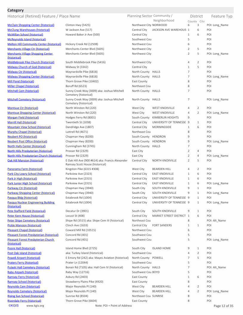
City County Neighborhoodhttps://www.kgis.org/kgismaps/map.htm? POI: Long_NameMcClain Shopping Center (historical) Northwest City NORWOOD 6 3Clinton Hwy (5425)
https://www.kgis.org/kgismaps/map.htm? POIMcClung Warehouses (historical) Central City JACKSON AVE WAREHOUS 1 6W Jackson Ave (517)
https://www.kgis.org/kgismaps/map.htm? POIMcMillan School (historical) Central City 1 6Howard Baker Jr Ave (500)
https://www.kgis.org/kgismaps/map.htm? POIMcReynolds Island (historical) Southwest Cou 5
https://www.kgis.org/kgismaps/map.htm? POIMelton Hill Community Center (historical) Northwest Cou 6Hickory Creek Rd (12508)
https://www.kgis.org/kgismaps/map.htm? POIMerchants Village Ctr (historical) Northwest City 2 5Merchants Center Blvd (5605)
https://www.kgis.org/kgismaps/map.htm? POI: Long_NameMerchants Village Shopping Center (historical)
Northwest City 2 5Merchants Center Blvd (5605)
https://www.kgis.org/kgismaps/map.htm? POIMiddlebrook Pike Church (historical) Northwest City 4 2South Middlebrook Pike (5416)
https://www.kgis.org/kgismaps/map.htm? POIMidway Church of God (historical) Central City 1 5Midway St (3342)
https://www.kgis.org/kgismaps/map.htm? POIMidway Ctr (historical) North County HALLS 7Maynardville Pike (6818)
https://www.kgis.org/kgismaps/map.htm? POI: Long_NameMidway Shopping Center (historical) North County HALLS 7Maynardville Pike (6818)
https://www.kgis.org/kgismaps/map.htm? POIMill Pond (historical) East County 8Thorn Grove Pike (10402)
https://www.kgis.org/kgismaps/map.htm? POIMitchell Cem (historical) North County HALLS 7Sunny Creek Way (3009) aka: Joshua Mitchell Cemetery (historical)
https://www.kgis.org/kgismaps/map.htm? POI: Long_NameMitchell Cemetery (historical) North County HALLS 7Sunny Creek Way (3009) aka: Joshua Mitchell Cemetery (historical)
https://www.kgis.org/kgismaps/map.htm? POIMontvue Ctr (historical) West City WEST KNOXVILLE 4 2North Winston Rd (220)
https://www.kgis.org/kgismaps/map.htm? POI: Long_NameMontvue Shopping Center (historical) West City WEST KNOXVILLE 4 2North Winston Rd (220)
https://www.kgis.org/kgismaps/map.htm? POIMorgan Field (historical) South County KIMBERLIN HEIGHTS 9Hodges Ferry Rd (8001)
https://www.kgis.org/kgismaps/map.htm? POIMorrill Hall (historical) Central City UNIVERSITY OF TENNESSE 9 1Twentieth St (1038)
https://www.kgis.org/kgismaps/map.htm? POIMountain View School (historical) Central City MORNINGSIDE 1 6Dandridge Ave (1807)
https://www.kgis.org/kgismaps/map.htm? POINeubert PO (historical) South County HENDRON 9Chapman Hwy (8200)
https://www.kgis.org/kgismaps/map.htm? POI: Long_NameNeubert Post Office (historical) South County HENDRON 9Chapman Hwy (8200)
https://www.kgis.org/kgismaps/map.htm? POINorth Halls Center (historical) North County HALLS 7Cunningham Rd (3745)
https://www.kgis.org/kgismaps/map.htm? POINorth Hills Presbyterian (historical) East City 2 4Prosser Rd (2329)
https://www.kgis.org/kgismaps/map.htm? POI: Long_NameNorth Hills Presbyterian Church (historical) East City 2 4Prosser Rd (2329)
https://www.kgis.org/kgismaps/map.htm? POIOak Hill Mansion (historical) Central City NORTH KNOXVILLE 2 5E Oak Hill Ave (900 #614) aka: Francis Alexander Ramsey Scott House (historical)
https://www.kgis.org/kgismaps/map.htm? POIPanorama Farm (historical) West City BEARDEN HILL 4 2Kingston Pike (6315 #308)
https://www.kgis.org/kgismaps/map.htm? POIPark City Lowry School (historical) Central City EAST KNOXVILLE 1 6Parkview Ave (2323)
https://www.kgis.org/kgismaps/map.htm? POIPark Jr High (historical) Central City EAST KNOXVILLE 1 6Parkview Ave (2315)
https://www.kgis.org/kgismaps/map.htm? POI: Long_NamePark Junior High School (historical) Central City EAST KNOXVILLE 1 6Parkview Ave (2315)
https://www.kgis.org/kgismaps/map.htm? POIParkway Ctr (historical) South City SOUTH KNOXVILLE 9 1Chapman Hwy (3940)
https://www.kgis.org/kgismaps/map.htm? POI: Long_NameParkway Shopping Center (historical) South City SOUTH KNOXVILLE 9 1Chapman Hwy (3940)
https://www.kgis.org/kgismaps/map.htm? POIPasqua Bldg (historical) Central City UNIVERSITY OF TENNESSE 9 1Estabrook Rd (1004)
https://www.kgis.org/kgismaps/map.htm? POI: Long_NamePasqua Nuclear Engineering Building (historical)
Central City UNIVERSITY OF TENNESSE 9 1Estabrook Rd (1004)
https://www.kgis.org/kgismaps/map.htm? POIPete Stafford Field (historical) South City SOUTH KNOXVILLE 9 1Decatur Dr (3901)
https://www.kgis.org/kgismaps/map.htm? POIPeter Kern House (historical) Central City MARKET STREET DISTRICT 1 6Locust St (408)
https://www.kgis.org/kgismaps/map.htm? POI: Alt_NamePeter Shipe Cemetery (historical) Northeast Cou 8Shipe Rd (3515) aka: Shipe Cem III (historical)
https://www.kgis.org/kgismaps/map.htm? POIPickle Mansion (historical) Central City FORT SANDERS 1 1Clinch Ave (1633)
https://www.kgis.org/kgismaps/map.htm? POI: Alt_NamePulaski Hall Cemetery (historical) North County HALLS 7Bonair Rd (7105) aka: Hall Cem IV (historical)
https://www.kgis.org/kgismaps/map.htm? POIRaby Airpark (historical) Southwest Cou BOYD 5Raby Way (12716)
https://www.kgis.org/kgismaps/map.htm? POIRamsey Ferry (historical) East County 1 6Asbury Rd (2403)
https://www.kgis.org/kgismaps/map.htm? POIRamsey School (historical) East County 8Strawberry Plains Pike (4920)
https://www.kgis.org/kgismaps/map.htm? POIReynolds Cem (historical) West City BEARDEN HILL 4 2Major Reynolds Pl (140)
https://www.kgis.org/kgismaps/map.htm? POI: Long_NameReynolds Cemetery (historical) West City BEARDEN HILL 4 2Major Reynolds Pl (140)
https://www.kgis.org/kgismaps/map.htm? POIRising Sun School (historical) Northeast Cou SUNRISE 8Sunrise Rd (8504)
https://www.kgis.org/kgismaps/map.htm? POIRiverdale Ferry (historical) East County 8Thorn Grove Pike (6604)
https://www.kgis.org/kgismaps/map.htm? POIS Knoxville Presbyterian (historical) South City SOUTH KNOXVILLE 9 1Chapman Hwy (2315) aka: South Knoxville Presbyterian Little Brown Church (historical)
https://www.kgis.org/kgismaps/map.htm? POIS Knoxville Presbyterian (historical) South City SOUTH WATERFRONT 9 1Chapman Hwy (2000)
https://www.kgis.org/kgismaps/map.htm? POIS Knoxville Quarry (historical) South City SOUTH KNOXVILLE 9 1Chapman Hwy (2418)
https://www.kgis.org/kgismaps/map.htm? POI: Long_NameSaint James Church (historical) Northeast Cou 8Sand Plant Ln (1730)
https://www.kgis.org/kgismaps/map.htm? POIShipe Cem III (historical) Northeast Cou 8Shipe Rd (3515) aka: Peter Shipe Cemetery (historical)
https://www.kgis.org/kgismaps/map.htm? POI: Long_NameShipe Cemetery III (historical) Northeast Cou 8Shipe Rd (3515) aka: Peter Shipe Cemetery (historical)
https://www.kgis.org/kgismaps/map.htm? POISimpson School (historical) South County 9Topside Rd (3402)
https://www.kgis.org/kgismaps/map.htm? POISkaggston Comm Park (historical) Northeast Cou 8Mcelhaney Dr (9707)
https://www.kgis.org/kgismaps/map.htm? POI: Long_NameSkaggston Community Park (historical) Northeast Cou 8Mcelhaney Dr (9707)
https://www.kgis.org/kgismaps/map.htm? POISkaggston School (historical) Northeast Cou SKAGGSTON 8Skaggston School Rd (9433)
https://www.kgis.org/kgismaps/map.htm? POISlatery Cem (historical) South County 9Rogers Ln (8330) aka: Slatery Mountain Cemetery (historical)
https://www.kgis.org/kgismaps/map.htm? POI: Long_NameSlatery Family Cemetery (historical) South County 9Rogers Ln (8330) aka: Slatery Mountain Cemetery (historical)
https://www.kgis.org/kgismaps/map.htm? POI: Alt_NameSlatery Mountain Cemetery (historical) South County 9Rogers Ln (8330) aka: Slatery Cem (historical)
https://www.kgis.org/kgismaps/map.htm? POISmith Coughlin House (historical) West City LYONS VIEW 4 2Lyons View Pike (5305)
https://www.kgis.org/kgismaps/map.htm? POISmith School (historical) East County KODAK 8Smith School Rd (1325)
https://www.kgis.org/kgismaps/map.htm? POI: Long_NameStokely Athletic Center (historical) Central City UNIVERSITY OF TENNESSE 9 2Johnny Majors Dr (1717) aka: Armory Fieldhouse (historical)
https://www.kgis.org/kgismaps/map.htm? POIStokely Athletic Ctr (historical) Central City UNIVERSITY OF TENNESSE 9 2Johnny Majors Dr (1717) aka: Armory Fieldhouse (historical)
https://www.kgis.org/kgismaps/map.htm? POI: Long_NameStony Point Baptist Church (historical) East County 8Stony Point Rd (2009)
https://www.kgis.org/kgismaps/map.htm? POI: Long_NameStony Point Church in Halls (historical) North County HALLS 7E Emory Rd (5113)
https://www.kgis.org/kgismaps/map.htm? POIStony Pt Baptist (historical) East County 8Stony Point Rd (2009)
https://www.kgis.org/kgismaps/map.htm? POIStony Pt Church Halls (historical) North County HALLS 7E Emory Rd (5113)
https://www.kgis.org/kgismaps/map.htm? POITaliaferro Island (historical) Southwest Cou 5
https://www.kgis.org/kgismaps/map.htm? POITan Rara Airport (historical) Southwest Cou TAN RARA 5Casa Real Cove (10040)
https://www.kgis.org/kgismaps/map.htm? POI: Alt_NameTarwater - Flenniken II Cemetery (historical) Southwest Cou RIVERBEND 4Lyons Bend Rd (2127) aka: Flenniken Cem (historical)
https://www.kgis.org/kgismaps/map.htm? POITarwater Cem (historical) South County 9Bud King Ln (8400) aka: Hahn - Tarwater Cemetery (historical)
https://www.kgis.org/kgismaps/map.htm? POI: Alt_NameTaylor Bridge (historical) East County 8 4Asheville Hwy (6110) aka: J Will Taylor Bridge (historical)
https://www.kgis.org/kgismaps/map.htm? POI: Long_NameTemple Court (historical) Central City UNIVERSITY OF TENNESSE 9 1Volunteer Blvd (804)
https://www.kgis.org/kgismaps/map.htm? POITemple Ct (historical) Central City UNIVERSITY OF TENNESSE 9 1Volunteer Blvd (804)
https://www.kgis.org/kgismaps/map.htm? POI: Alt_NameTerminal Building (historical) Central City DOWNTOWN 1 6S Gay St (322) aka: Union Bus Terminal (historical)
https://www.kgis.org/kgismaps/map.htm? POIThe Bowery (historical) Central City DOWNTOWN 1 6S Central St (300)
https://www.kgis.org/kgismaps/map.htm? POIThe Deanery (historical) West City DEANE HILL 4 2Catherine Mcauley Way (401) aka: Deane Hill Country Club
https://www.kgis.org/kgismaps/map.htm? POI: Long_NameThe Deanery Clubhouse (historical) West City DEANE HILL 4 2Catherine Mcauley Way (401) aka: Deane Hill Country Club
https://www.kgis.org/kgismaps/map.htm? POI: Long_NameThe Gate Sculpture (historical) South City VESTAL 9 1Maryville Pike (401)
https://www.kgis.org/kgismaps/map.htm? POI: Alt_NameThe Governors House (historical) Central City FOURTH & GILL 2 4N Fourth Ave (803) aka: Caswell Taylor House (historical)
https://www.kgis.org/kgismaps/map.htm? POI: Long_NameThe Sprankle Building (historical) Central City MARKET STREET DISTRICT 1 6Union Ave (428)
https://www.kgis.org/kgismaps/map.htm? POIThomas Cem (historical) Northeast Cou 8Harris Rd (1702)
https://www.kgis.org/kgismaps/map.htm? POI: Long_NameThomas J Walker House (historical) Northwest Cou 4 2Mars Hill Rd (645)
https://www.kgis.org/kgismaps/map.htm? POIThomas Walker House (historical) Northwest Cou 4 2Mars Hill Rd (645)
https://www.kgis.org/kgismaps/map.htm? POIThompson School (historical) Northeast Cou CLEAR SPRINGS 8Thompson School Rd (8518)
https://www.kgis.org/kgismaps/map.htm? POIThree Rivers Boat Ramp (historical) East County FORKS OF THE RIVER 8Asbury Rd (2403)
https://www.kgis.org/kgismaps/map.htm? POI: Alt_NameTillery Cemetery (historical) North City DANTE 7Kern Rd (6601) aka: Callahan Cem (historical)
https://www.kgis.org/kgismaps/map.htm? POITreble Clef Statue (historical) Central City DOWNTOWN 1 6W Summit Hill Dr (207)
https://www.kgis.org/kgismaps/map.htm? POITrinity Church (historical) East County 8N East End Rd (803)
https://www.kgis.org/kgismaps/map.htm? POI: Long_NameTSD Poore Hall (historical) South City ISLAND HOME 9 1Island Home Blvd (2725)
https://www.kgis.org/kgismaps/map.htm? POI: Alt_NameTurkey Island (historical) Southwest Cou 4 2aka: Post Oak Island (historical)
https://www.kgis.org/kgismaps/map.htm? POIUnion Bus Terminal (historical) Central City DOWNTOWN 1 6S Gay St (322) aka: Terminal Building (historical)
https://www.kgis.org/kgismaps/map.htm? POIUniversity Center (historical) Central City UNIVERSITY OF TENNESSE 9 1Cumberland Ave (1502)
https://www.kgis.org/kgismaps/map.htm? POI: Alt_NameUnnamed Cemetery West City BEARDEN 4 2Baum Dr (6431) aka: James Miller Cem (historical)
https://www.kgis.org/kgismaps/map.htm? POIUnnamed Cemetery (historical) Central City 3 3Sanderson Rd (2917)
https://www.kgis.org/kgismaps/map.htm? POIUnnamed Cemetery (historical) Northeast Cou 8E Emory Rd (10023)
https://www.kgis.org/kgismaps/map.htm? POIUphostery Bldg (historical) West City LYONS VIEW 4 2Lyons View Pike (5930)
https://www.kgis.org/kgismaps/map.htm? POI: Long_NameUphostery Building at Lakeshore (historical) West City LYONS VIEW 4 2Lyons View Pike (5930)
https://www.kgis.org/kgismaps/map.htm? POI: Alt_NameUT Anthopology (historical) Central City UNIVERSITY OF TENNESSE 9 1Neyland Dr (901) aka: Biology Annex (historical)
https://www.kgis.org/kgismaps/map.htm? POI: Long_NameUT Berry Hall (historical) Central City UNIVERSITY OF TENNESSE 9 1Estabrook Rd (1012)
https://www.kgis.org/kgismaps/map.htm? POI: Long_NameUT Biology Annex Building (historical) Central City UNIVERSITY OF TENNESSE 9 1Neyland Dr (901) aka: UT Anthopology (historical)
https://www.kgis.org/kgismaps/map.htm? POIUT Child Dev (historical) West City POND GAP 4 6Hospitality Cir (6908) aka: UT Early Learning Center Labratory (historical)
https://www.kgis.org/kgismaps/map.htm? POI: Long_NameUT Child Development Institute (historical) West City POND GAP 4 6Hospitality Cir (6908) aka: UT Early Learning Center Labratory (historical)
https://www.kgis.org/kgismaps/map.htm? POI: Alt_NameUT Early Learning Center Labratory (historical)
West City POND GAP 4 6Hospitality Cir (6908) aka: UT Child Dev (historical)
https://www.kgis.org/kgismaps/map.htm? POI: Long_NameUT Humes Hall (historical) Central City UNIVERSITY OF TENNESSE 9 1Andy Holt Ave (1911)
Historical (Retired) Feature / Place Name Planning Sector Feature Typ
CategoryCommunity / District
City County Neighborhoodhttps://www.kgis.org/kgismaps/map.htm? POI: Long_NameUT Morrill Hall (historical) Central City UNIVERSITY OF TENNESSE 9 1Twentieth St (1038)
https://www.kgis.org/kgismaps/map.htm? POIUT Sports Bubble (historical) Central City UNIVERSITY OF TENNESSE 9 2Andy Holt Ave (1920)
https://www.kgis.org/kgismaps/map.htm? POIVillage Mall Bldg (historical) West City LYONS VIEW 4 2S Northshore Dr (6404)
https://www.kgis.org/kgismaps/map.htm? POI: Long_NameVillage Mall Building at Lakeshore (historical) West City LYONS VIEW 4 2S Northshore Dr (6404)
https://www.kgis.org/kgismaps/map.htm? POIWaterside Bldg (historical) West City LYONS VIEW 4 2S Northshore Dr (6400)
https://www.kgis.org/kgismaps/map.htm? POI: Long_NameWaterside Building at Lakeshore (historical) West City LYONS VIEW 4 2S Northshore Dr (6400)
https://www.kgis.org/kgismaps/map.htm? POIWeston Fulton House (historical) Central City UNIVERSITY OF TENNESSE 9 1Volunteer Blvd (900) aka: Weston M Fulton Jr Memorial Hospital (historical)
https://www.kgis.org/kgismaps/map.htm? POI: Alt_NameWeston M Fulton Jr Memorial Hospital (historical)
Central City UNIVERSITY OF TENNESSE 9 1Volunteer Blvd (900) aka: Weston Fulton House (historical)
https://www.kgis.org/kgismaps/map.htm? POIWhittle Springs Hotel (historical) East City WHITTLE SPRINGS 2 4Mineral Springs Ave (2704)
https://www.kgis.org/kgismaps/map.htm? POI: Long_NameWhittle Springs Resort Hotel (historical) East City WHITTLE SPRINGS 2 4Mineral Springs Ave (2704)
https://www.kgis.org/kgismaps/map.htm? POIWilliams Senior Ctr (historical) Central City FIVE POINTS 1 6Martin Luther King Jr Ave (2240) aka: Dr Lee Williams Complex (historical)
https://www.kgis.org/kgismaps/map.htm? POIYork Cem II (historical) Northwest City 4 2Old Weisgarber Rd (1254)
https://www.kgis.org/kgismaps/map.htm? POI: Long_NameYork Cemetery II (historical) Northwest City 4 2Old Weisgarber Rd (1254)
Historical:Feature Still Existshttps://www.kgis.org/kgismaps/map.htm? POI: Alt_Name1st Baptist Church of Fountain City (historical)
North City FOUNTAIN CITY 2 4Holbrook Dr (2619) aka: First Baptist of Ftn City (historical)
https://www.kgis.org/kgismaps/map.htm? POI: Alt_Name1st Congregational Church of Knoxville (historical)
Northwest City 4 2N Weisgarber Rd (934) aka: First Congregational Church (historical)
https://www.kgis.org/kgismaps/map.htm? POI: Alt_Name1st Landmark Missionary Baptist Church (historical)
Northwest Cou 6Hickey Rd (1321) aka: First Landmark Baptist (historical)
https://www.kgis.org/kgismaps/map.htm? POI: Alt_Name1st Trinity Wesleyan Church (historical) Central City NORTH KNOXVILLE 2 5E Emerald Ave (506) aka: First Trinity Wesleyan (historical)
https://www.kgis.org/kgismaps/map.htm? POI: Alt_Name1st United Presbyterian Church (historical) Central City MECHANICSVILLE 1 6Knoxville College Dr (809) aka: First United Presbyterian (historical)
https://www.kgis.org/kgismaps/map.htm? POI9th Ward School (historical) Central City MECHANICSVILLE 1 6Carrick St (220)
https://www.kgis.org/kgismaps/map.htm? POIA K Stewart Science Bldg (historical) Central City MECHANICSVILLE 1 6Knoxville College Dr (915)
https://www.kgis.org/kgismaps/map.htm? POI: Long_NameA K Stewart Science Building (historical) Central City MECHANICSVILLE 1 6Knoxville College Dr (915)
https://www.kgis.org/kgismaps/map.htm? POIAhlulbayt Islamic Center (historical) South City SOUTH KNOXVILLE 9 1Chapman Hwy (3607)
https://www.kgis.org/kgismaps/map.htm? POI: Long_NameAichton Memorial Baptist Church (historical) Southwest Cou CONCORD 5Loop Rd (801)
https://www.kgis.org/kgismaps/map.htm? POIAmazing Grace Assembly (historical) Central City 2 5W Columbia Ave (123) aka: Fountain of Life Assembly of God (historical)
https://www.kgis.org/kgismaps/map.htm? POI: Long_NameAmazing Grace Assembly of God (historical) Central City 2 5W Columbia Ave (123) aka: Fountain of Life Assembly of God (historical)
East City PARK CITY 1 6Selma Ave (2834) aka: Knoxville Masonic Lodge (historical)
https://www.kgis.org/kgismaps/map.htm? POIAnderson Elem (historical) South County 9 1Prospect Rd (4808)
https://www.kgis.org/kgismaps/map.htm? POI: Long_NameAnderson Elementary School (historical) South County 9 1Prospect Rd (4808)
https://www.kgis.org/kgismaps/map.htm? POIAppalachian Child Dev (historical) West City 4 2Gleason Rd (8042)
https://www.kgis.org/kgismaps/map.htm? POI: Long_NameAppalachian Regional Child Development Center (historical)
West City 4 2Gleason Rd (8042)
https://www.kgis.org/kgismaps/map.htm? POIArminda School (historical) Northeast Cou ARMINDA 8Ellistown Rd (2124)
https://www.kgis.org/kgismaps/map.htm? POIAult Rd Church of Christ (historical) East City 1 4Ault Rd (1501)
https://www.kgis.org/kgismaps/map.htm? POI: Long_NameAult Road Church of Christ (historical) East City 1 4Ault Rd (1501)
https://www.kgis.org/kgismaps/map.htm? POIAustin High (historical) Central City EAST KNOXVILLE 1 6Martin Luther King Jr Ave (1807)
https://www.kgis.org/kgismaps/map.htm? POI: Long_NameAustin High School (historical) Central City EAST KNOXVILLE 1 6Martin Luther King Jr Ave (1807)
https://www.kgis.org/kgismaps/map.htm? POIAustin Homes Rec Ctr (historical) Central City EAST KNOXVILLE 1 6Martin Luther King Jr Ave (1807)
https://www.kgis.org/kgismaps/map.htm? POI: Long_NameAustin Homes Recreation Center (historical) Central City EAST KNOXVILLE 1 6Martin Luther King Jr Ave (1807)
https://www.kgis.org/kgismaps/map.htm? POIAvenue A Church of God (historical) South City VESTAL 9 1Avenue A (1109)
https://www.kgis.org/kgismaps/map.htm? POIBaker Chapel Baptist (historical) Central City MARBLE CITY 1 6Sutherland Ave (2554)
https://www.kgis.org/kgismaps/map.htm? POI: Long_NameBaker Chapel United Baptist Church (historical)
Central City MARBLE CITY 1 6Sutherland Ave (2554)
https://www.kgis.org/kgismaps/map.htm? POIBall Rd Church of God (historical) Northwest Cou 6Ball Rd (6111)
https://www.kgis.org/kgismaps/map.htm? POI: Long_NameBall Road Church of God (historical) Northwest Cou 6Ball Rd (6111)
https://www.kgis.org/kgismaps/map.htm? POIBaptist Hosp (historical) South City SOUTH WATERFRONT 9 1E Blount Ave (221) aka: Tennova Hosptial Riverside (historical)
https://www.kgis.org/kgismaps/map.htm? POIBaptist Hospital Chapel (historical) South City SOUTH WATERFRONT 9 1E Blount Ave (151)
Historical (Retired) Feature / Place Name Planning Sector Feature Typ
CategoryCommunity / District
City County Neighborhoodhttps://www.kgis.org/kgismaps/map.htm? POIBarbara Hill (historical) Central City UNIVERSITY OF TENNESSE 9 1Circle Dr (1403) aka: University Hill
https://www.kgis.org/kgismaps/map.htm? POIBarner Cem (historical) North County HALLS 7E Emory Rd (4822 #B)
https://www.kgis.org/kgismaps/map.htm? POI: Long_NameBarner Cemetery (historical) North County HALLS 7E Emory Rd (4822 #B)
https://www.kgis.org/kgismaps/map.htm? POIBaxter Ave Baptist (historical) Central City MECHANICSVILLE 1 6W Baxter Ave (923) aka: New Victory Baptist Church (historical)
https://www.kgis.org/kgismaps/map.htm? POIBearden Christian (historical) West City BEARDEN 4 2Kingston Pike (5902) aka: Korean Christian Church of Bearden (historical)
https://www.kgis.org/kgismaps/map.htm? POI: Long_NameBearden Christian Church (historical) West City BEARDEN 4 2Kingston Pike (5902) aka: Korean Christian Church of Bearden (historical)
https://www.kgis.org/kgismaps/map.htm? POIBeardsley Middle (historical) Central City MECHANICSVILLE 1 6Reynolds St (1719)
https://www.kgis.org/kgismaps/map.htm? POI: Long_NameBeardsley Middle School (historical) Central City MECHANICSVILLE 1 6Reynolds St (1719)
https://www.kgis.org/kgismaps/map.htm? POIBeech Grove Cem (historical) Northwest Cou 6Blacks Ferry Rd (8011)
https://www.kgis.org/kgismaps/map.htm? POIBell Ave Baptist (historical) East City CHILHOWEE HILLS 1 6Asheville Hwy (4615)
https://www.kgis.org/kgismaps/map.htm? POI: Long_NameBell Avenue Baptist Church (historical) East City CHILHOWEE HILLS 1 6Asheville Hwy (4615)
https://www.kgis.org/kgismaps/map.htm? POIBell Cem II (historical) East County 8S Patty Rd (215)
https://www.kgis.org/kgismaps/map.htm? POI: Long_NameBell Cemetery II (historical) East County 8S Patty Rd (215)
https://www.kgis.org/kgismaps/map.htm? POIBelleview Cem (historical) Central City EAST KNOXVILLE 1 6Martin Luther King Jr Ave (2020) aka: Bellevue County Cemetery (historical)
https://www.kgis.org/kgismaps/map.htm? POI: Long_NameBelleview County Cemetery (historical) Central City EAST KNOXVILLE 1 6Martin Luther King Jr Ave (2020) aka: Bellevue County Cemetery (historical)
https://www.kgis.org/kgismaps/map.htm? POI: Alt_NameBellevue County Cemetery (historical) Central City EAST KNOXVILLE 1 6Martin Luther King Jr Ave (2020) aka: Belleview Cem (historical)
https://www.kgis.org/kgismaps/map.htm? POIBerea Baptist (Pond Gap) (historical) Central City POND GAP 1 6Washburn Rd (704)
https://www.kgis.org/kgismaps/map.htm? POI: Long_NameBerea Baptist Church (Pond Gap) (historical) Central City POND GAP 1 6Washburn Rd (704)
https://www.kgis.org/kgismaps/map.htm? POIBerkeley St (historical) East City FAIRMONT EMORILAND 2 4Fairmont Blvd (1706)
https://www.kgis.org/kgismaps/map.htm? POI: Long_NameBethel African Methodist Episcopal (AME) Church (historical)
East City EAST KNOXVILLE 1 6Boyds Bridge Pike (3811)
https://www.kgis.org/kgismaps/map.htm? POIBethel AME (historical) East City EAST KNOXVILLE 1 6Boyds Bridge Pike (3811)
https://www.kgis.org/kgismaps/map.htm? POIBethesda Baptist (historical) Central City NEW TOWN 1 6Glider Ave (1000)
https://www.kgis.org/kgismaps/map.htm? POI: Long_NameBethesda Baptist Church (historical) Central City NEW TOWN 1 6Glider Ave (1000)
https://www.kgis.org/kgismaps/map.htm? POIBethesda Christian Fellowship (historical) North City 2 5Cedar Ln (1015) aka: Christ Chapel (Bethesda) Christian Fellowship Church (historical)
https://www.kgis.org/kgismaps/map.htm? POI: Long_NameBishop Shea Knights of Columbus Council Hall (historical)
Northeast Cou MILLERTOWN 8Millertown Pike (6515)
https://www.kgis.org/kgismaps/map.htm? POIBlind Hill (historical) West City LYONS VIEW 4 2S Northshore Dr (6414)
https://www.kgis.org/kgismaps/map.htm? POIBlount Ave Baptist (historical) South City SOUTH KNOXVILLE 9 1Wrinkle Ave (137) aka: Blount Avenue Missionary Baptist Church (historical)
https://www.kgis.org/kgismaps/map.htm? POI: Long_NameBlount Avenue Baptist Church (historical) South City SOUTH KNOXVILLE 9 1Wrinkle Ave (137) aka: Blount Avenue Missionary Baptist Church (historical)
https://www.kgis.org/kgismaps/map.htm? POI: Alt_NameBlount Avenue Missionary Baptist Church (historical)
South City SOUTH KNOXVILLE 9 1Wrinkle Ave (137) aka: Blount Ave Baptist (historical)
https://www.kgis.org/kgismaps/map.htm? POIBrandon Hall (historical) Central City MECHANICSVILLE 1 6Knoxville College Dr (927)
https://www.kgis.org/kgismaps/map.htm? POI: Long_NameBridgewater Baptist Church (historical) Northwest Cou WEST KNOXVILLE 3 2Bridgewater Rd (205)
https://www.kgis.org/kgismaps/map.htm? POIBright Hope Church (historical) North County HALLS 7Maynardville Pike (6612)
https://www.kgis.org/kgismaps/map.htm? POIBrown Gap Church (historical) North County 7Mcfall Rd (6571)
https://www.kgis.org/kgismaps/map.htm? POIBrownlow Elementary (historical) Central City FOURTH & GILL 2 4Luttrell St (1305) aka: Brownlow School Lofts
https://www.kgis.org/kgismaps/map.htm? POI: Long_NameBrownlow Elementary School (historical) Central City FOURTH & GILL 2 4Luttrell St (1305) aka: Brownlow School Lofts
Historical (Retired) Feature / Place Name Planning Sector Feature Typ
CategoryCommunity / District
City County Neighborhoodhttps://www.kgis.org/kgismaps/map.htm? POI: Alt_NameBrownlow School Lofts Central City FOURTH & GILL 2 4Luttrell St (1305) aka: Brownlow Elementary
(historical)
https://www.kgis.org/kgismaps/map.htm? POIBrushy Valley Church (historical) North County 7W Brushy Valley Dr (1904)
https://www.kgis.org/kgismaps/map.htm? POI: Long_NameBuffat Heights Baptist Church (historical) East City 1 4Ault Rd (2101)
https://www.kgis.org/kgismaps/map.htm? POIBuffat Hgts Baptist (historical) East City 1 4Ault Rd (2101)
https://www.kgis.org/kgismaps/map.htm? POIBurlington Church of God (historical) East City BURLINGTON 1 6Speedway Cir (3819)
https://www.kgis.org/kgismaps/map.htm? POI: Long_NameBurlington East Knox County Health Department Clinic (historical)
East City BURLINGTON 1 6Asheville Hwy (4510)
https://www.kgis.org/kgismaps/map.htm? POIBurlington Methodist (historical) East City BURLINGTON 1 6Fern St (121) aka: Burlington Methodist Episcopal Church (historical)
https://www.kgis.org/kgismaps/map.htm? POI: Alt_NameBurlington Methodist Episcopal Church (historical)
East City BURLINGTON 1 6Fern St (121) aka: Burlington Methodist (historical)
https://www.kgis.org/kgismaps/map.htm? POI: Long_NameBurlington United Methodist Church (historical)
East City BURLINGTON 1 6Fern St (121) aka: Burlington Methodist Episcopal Church (historical)
https://www.kgis.org/kgismaps/map.htm? POIByington Church (historical) Northwest Cou 6Ball Rd (6111)
https://www.kgis.org/kgismaps/map.htm? POICalvary Baptist (Midlands) (historical) Central City MECHANICSVILLE 1 6W Baxter Ave (923) aka: W Baxter Avenue Missionary Baptist Church (historical)
https://www.kgis.org/kgismaps/map.htm? POI: Long_NameCalvary Baptist Church of the Midlands Association (historical)
Central City MECHANICSVILLE 1 6W Baxter Ave (923) aka: W Baxter Avenue Missionary Baptist Church (historical)
https://www.kgis.org/kgismaps/map.htm? POICalvarys Cross Church (historical) South City VESTAL 9 1Avenue A (833)
https://www.kgis.org/kgismaps/map.htm? POI: Long_NameCalvarys Cross Community Church (historical)
https://www.kgis.org/kgismaps/map.htm? POICapri 70 Cinema (historical) West City BEARDEN 4 2Kingston Pike (5308) aka: Capri Cinema III - IV (historical)
https://www.kgis.org/kgismaps/map.htm? POI: Long_NameCapri 70 Cinerama Cinema (historical) West City BEARDEN 4 2Kingston Pike (5308) aka: Capri Cinema III - IV (historical)
https://www.kgis.org/kgismaps/map.htm? POI: Alt_NameCapri Cinema I - II (historical) West City BEARDEN 4 2Kingston Pike (5308) aka: Pike Theatre (historical)
https://www.kgis.org/kgismaps/map.htm? POI: Alt_NameCapri Cinema III - IV (historical) West City BEARDEN 4 2Kingston Pike (5308) aka: Capri 70 Cinema (historical)
https://www.kgis.org/kgismaps/map.htm? POICapri Terrace Cinema (historical) West City HOMBERG PLACE 4 2S Mohican St (315) aka: Terrace Tap House (historical)
https://www.kgis.org/kgismaps/map.htm? POICarter Community Park (historical) East County CARTER 8Carter Mill Dr (9204)
https://www.kgis.org/kgismaps/map.htm? POI: Alt_NameCedar Grove Plantation House (historical) Central City NORTH KNOXVILLE 2 5Oglewood Ave (1304) aka: Scott House (historical)
https://www.kgis.org/kgismaps/map.htm? POI: Alt_NameCenterpointe Baptist Church (historical); Amazing Church (historical)
Central City NORTH KNOXVILLE 2 5N Broadway (2909) aka: Second Baptist (historical)
https://www.kgis.org/kgismaps/map.htm? POICentral Church of God (historical) Northwest City POND GAP 1 6Papermill Dr (4029)
https://www.kgis.org/kgismaps/map.htm? POICherry St Church of God (historical) East City PARK CITY 1 6S Cherry St (729)
https://www.kgis.org/kgismaps/map.htm? POI: Long_NameCherry Street Church of God (historical) East City PARK CITY 1 6S Cherry St (729)
https://www.kgis.org/kgismaps/map.htm? POIChildren of God Church (historical) Central City LONSDALE 1 5Texas Ave (1300)
https://www.kgis.org/kgismaps/map.htm? POIChoto Church (historical) Southwest Cou CHOTO BEND 5Early Rd (12301)
https://www.kgis.org/kgismaps/map.htm? POI: Long_NameChoto Presbyterian Church (historical) Southwest Cou CHOTO BEND 5Early Rd (12301)
https://www.kgis.org/kgismaps/map.htm? POI: Alt_NameChrist Chapel (Bethesda) Christian Fellowship Church (historical)
North City 2 5Cedar Ln (1015) aka: Bethesda Christian Fellowship (historical)
https://www.kgis.org/kgismaps/map.htm? POIChrist Way Ministries (historical) Central City WEST VIEW 1 3Keith Ave (3220)
https://www.kgis.org/kgismaps/map.htm? POI: Alt_NameCollege Street Cemetery (historical) Central City MECHANICSVILLE 1 6College St (1100) aka: Knoxville College Cem (historical)
https://www.kgis.org/kgismaps/map.htm? POI: Long_NameColston Center for the Performing Arts (historical)
Central City MECHANICSVILLE 1 6Knoxville College Dr (971)
https://www.kgis.org/kgismaps/map.htm? POIColston Ctr (historical) Central City MECHANICSVILLE 1 6Knoxville College Dr (971)
https://www.kgis.org/kgismaps/map.htm? POIColston Hall (historical) Central City MECHANICSVILLE 1 6Knoxville College Dr (941)
https://www.kgis.org/kgismaps/map.htm? POICommunity Chapel (historical) East City BURLINGTON 1 6Skyline Dr (4111) aka: Freedom Heart Worship Center (historical)
https://www.kgis.org/kgismaps/map.htm? POI: Long_NameCommunity Chapel Church (historical) East City BURLINGTON 1 6Skyline Dr (4111) aka: Freedom Heart Worship Center (historical)
https://www.kgis.org/kgismaps/map.htm? POICommunity Chapel Church (historical) Central City LINWOOD 2 5Atlantic Ave (401)
https://www.kgis.org/kgismaps/map.htm? POI: Long_NameEast Tennessee Discovery Center (historical) East City PARK CITY 1 6N Beaman St (516)
https://www.kgis.org/kgismaps/map.htm? POI: Long_NameEast Tennessee State Hospital Tooles Farm Dormitory (historical)
Southwest Cou TOOLES BEND 4Tooles Bend Rd (2616) aka: Eastern State Mental Hospital Farm Dormitory (historical)
https://www.kgis.org/kgismaps/map.htm? POIEast TN Chest Disease Hosp (historical) North City 2Beverly Park Cir (5325)
https://www.kgis.org/kgismaps/map.htm? POIEast Towne Mall (historical) North City 2 4Knoxville Center Dr (3001) aka: Knoxville Center Mall (historical)
https://www.kgis.org/kgismaps/map.htm? POIEastern St Dormitory (historical) Southwest Cou TOOLES BEND 4Tooles Bend Rd (2616) aka: Eastern State Mental Hospital Farm Dormitory (historical)
https://www.kgis.org/kgismaps/map.htm? POIEastern State Hospital Farm (historical) East City 1 6Kreis Rd (3835) aka: Kreis Riverside Dairy Farm (historical)
https://www.kgis.org/kgismaps/map.htm? POI: Alt_NameEastern State Mental Hospital Farm Dormitory (historical)
Southwest Cou TOOLES BEND 4Tooles Bend Rd (2616) aka: Eastern St Dormitory (historical)
https://www.kgis.org/kgismaps/map.htm? POI: Long_NameEastern State Wildlife Management Area (historical)
South County 9 1Mcclure Ln (3140)
https://www.kgis.org/kgismaps/map.htm? POIEastern State WMA (historical) South County 9 1Mcclure Ln (3140)
https://www.kgis.org/kgismaps/map.htm? POIEastport Elem (historical) Central City FIVE POINTS 1 6Bethel Ave (2036)
https://www.kgis.org/kgismaps/map.htm? POI: Long_NameEastport Elementary School (historical) Central City FIVE POINTS 1 6Bethel Ave (2036)
https://www.kgis.org/kgismaps/map.htm? POIEl Hussin Mosque (historical) South City 9 1Chapman Hwy (6622)
https://www.kgis.org/kgismaps/map.htm? POIElnathan Hall (historical) Central City MECHANICSVILLE 1 6Knoxville College Dr (835)
https://www.kgis.org/kgismaps/map.htm? POIET Discovery Ctr (historical) East City PARK CITY 1 6N Beaman St (516)
https://www.kgis.org/kgismaps/map.htm? POIEuclid Ave Baptist (historical) Central City 1 6Donald Lee Derrickson Ave (1954)
https://www.kgis.org/kgismaps/map.htm? POI: Long_NameEuclid Avenue Baptist Church (historical) Central City 1 6Donald Lee Derrickson Ave (1954)
https://www.kgis.org/kgismaps/map.htm? POIEureka Church (historical) East City 2 4Fairway Rd (2901)
https://www.kgis.org/kgismaps/map.htm? POIFellowship Baptist (historical) South County 9E Governor John Sevier Hwy (1204)
https://www.kgis.org/kgismaps/map.htm? POI: Long_NameFellowship Baptist Church (historical) South County 9E Governor John Sevier Hwy (1204)
https://www.kgis.org/kgismaps/map.htm? POIFirst 7th Day Adventist (historical) Central City FOURTH & GILL 2 4Luttrell St (800) aka: Friends (Quaker) Church (historical)
https://www.kgis.org/kgismaps/map.htm? POI: Long_NameFirst Baptist Church of Fountain City (historical)
North City FOUNTAIN CITY 2 4Holbrook Dr (2619) aka: 1st Baptist Church of Fountain City (historical)
https://www.kgis.org/kgismaps/map.htm? POIFirst Baptist of Ftn City (historical) North City FOUNTAIN CITY 2 4Holbrook Dr (2619) aka: 1st Baptist Church of Fountain City (historical)
https://www.kgis.org/kgismaps/map.htm? POIFirst Church of Voodoo (historical) East City PARK CITY 1 6E Fifth Ave (2827 #1)
https://www.kgis.org/kgismaps/map.htm? POIFirst Congregational Church (historical) Northwest City 4 2N Weisgarber Rd (934) aka: 1st Congregational Church of Knoxville (historical)
https://www.kgis.org/kgismaps/map.htm? POI: Long_NameFirst Congregational Church of Knoxville (historical)
Northwest City 4 2N Weisgarber Rd (934) aka: 1st Congregational Church of Knoxville (historical)
https://www.kgis.org/kgismaps/map.htm? POI: Alt_NameFirst Friends Quaker Church (historical) Central City PARKRIDGE 1 6Washington Ave (2100) aka: Greater Refuge Temple (historical)
https://www.kgis.org/kgismaps/map.htm? POI: Long_NameFirst Seventh Day Adventist Church (historical)
Central City FOURTH & GILL 2 4Luttrell St (800) aka: Friends (Quaker) Church (historical)
https://www.kgis.org/kgismaps/map.htm? POIFirst Trinity Wesleyan (historical) Central City NORTH KNOXVILLE 2 5E Emerald Ave (506) aka: 1st Trinity Wesleyan Church (historical)
https://www.kgis.org/kgismaps/map.htm? POI: Long_NameFirst Trinity Wesleyan Church (historical) Central City NORTH KNOXVILLE 2 5E Emerald Ave (506) aka: 1st Trinity Wesleyan Church (historical)
https://www.kgis.org/kgismaps/map.htm? POIFirst United Presbyterian (historical) Central City MECHANICSVILLE 1 6Knoxville College Dr (809) aka: 1st United Presbyterian Church (historical)
https://www.kgis.org/kgismaps/map.htm? POI: Long_NameFirst United Presbyterian Church (historical) Central City MECHANICSVILLE 1 6Knoxville College Dr (809) aka: 1st United Presbyterian Church (historical)
https://www.kgis.org/kgismaps/map.htm? POIFlagpole Hill (historical) Central City MECHANICSVILLE 1 6
https://www.kgis.org/kgismaps/map.htm? POIFlenniken Elem (historical) South City SOUTH KNOXVILLE 9 1Flenniken Ave (115)
https://www.kgis.org/kgismaps/map.htm? POI: Long_NameFlenniken Elementary School (historical) South City SOUTH KNOXVILLE 9 1Flenniken Ave (115)
https://www.kgis.org/kgismaps/map.htm? POI: Long_NameFort Sanders Baptist Church (historical) Central City FORT SANDERS 1 1Highland Ave (1648)
https://www.kgis.org/kgismaps/map.htm? POI: Long_NameFort Sanders Trail (historical) West City LYONS VIEW 4 2Lyons View Pike (6014)
https://www.kgis.org/kgismaps/map.htm? POI: Alt_NameFountain of Life Assembly of God (historical) Central City 2 5W Columbia Ave (123) aka: Amazing Grace Assembly (historical)
https://www.kgis.org/kgismaps/map.htm? POIFountainhead College (historical) North City SMITHWOOD 2 4Tazewell Pike (3203)
https://www.kgis.org/kgismaps/map.htm? POI: Long_NameFountainhead College of Technology (historical)
https://www.kgis.org/kgismaps/map.htm? POI: Long_NameFreedom Fellowship Baptist Church (historical)
Northeast Cou SHIPETOWN 8A Dr (8901)
https://www.kgis.org/kgismaps/map.htm? POI: Alt_NameFreedom Heart Worship Center (historical) East City BURLINGTON 1 6Skyline Dr (4111) aka: Community Chapel (historical)
https://www.kgis.org/kgismaps/map.htm? POI: Long_NameFreedom Worship Center (historical) East County 8Strawberry Plains Pike (5637)
https://www.kgis.org/kgismaps/map.htm? POIFreedom Worship Ctr (historical) East County 8Strawberry Plains Pike (5637)
Historical (Retired) Feature / Place Name Planning Sector Feature Typ
CategoryCommunity / District
City County Neighborhoodhttps://www.kgis.org/kgismaps/map.htm? POI: Alt_NameFriends (Quaker) Church (historical) Central City FOURTH & GILL 2 4Luttrell St (800) aka: First 7th Day Adventist
(historical)
https://www.kgis.org/kgismaps/map.htm? POIFt Sanders Baptist (historical) Central City FORT SANDERS 1 1Highland Ave (1648)
https://www.kgis.org/kgismaps/map.htm? POIFt Sanders Trl (historical) West City LYONS VIEW 4 2Lyons View Pike (6014)
https://www.kgis.org/kgismaps/map.htm? POIFullwood Chapel (historical) North City OAK GROVE 2 4Washington Pike (5667)
https://www.kgis.org/kgismaps/map.htm? POI: Long_NameFullwood Chapel Church (historical) North City OAK GROVE 2 4Washington Pike (5667)
https://www.kgis.org/kgismaps/map.htm? POIGalbraith School (historical) South City SOUTH KNOXVILLE 9 1Galbraith School Rd (4333)
https://www.kgis.org/kgismaps/map.htm? POI: Long_NameGayland Heights Baptist Church (historical) South City VESTAL 9 1Willoughby Rd (1517)
https://www.kgis.org/kgismaps/map.htm? POIGayland Hgts Baptist (historical) South City VESTAL 9 1Willoughby Rd (1517)
https://www.kgis.org/kgismaps/map.htm? POIGiffin Elem (historical) South City SOUTH HAVEN 9 1Beech St (1834)
https://www.kgis.org/kgismaps/map.htm? POI: Long_NameGiffin Elementary School (historical) South City SOUTH HAVEN 9 1Beech St (1834)
https://www.kgis.org/kgismaps/map.htm? POIGiffin Mem Gym (historical) Central City MECHANICSVILLE 1 6Knoxville College Dr (975)
https://www.kgis.org/kgismaps/map.htm? POI: Long_NameGiffin Memorial Gymnasium (historical) Central City MECHANICSVILLE 1 6Knoxville College Dr (975)
https://www.kgis.org/kgismaps/map.htm? POIGlen Oak Methodist (historical) Central City OLD NORTH KNOXVILLE 2 4E Oklahoma Ave (510)
https://www.kgis.org/kgismaps/map.htm? POI: Long_NameGlen Oak United Methodist Church (historical)
Central City OLD NORTH KNOXVILLE 2 4E Oklahoma Ave (510)
https://www.kgis.org/kgismaps/map.htm? POIGreater Refuge Temple (historical) Central City PARKRIDGE 1 6Washington Ave (2100) aka: First Friends Quaker Church (historical)
https://www.kgis.org/kgismaps/map.htm? POIGreater Warner AME (historical) East City BURLINGTON 1 6Speedway Cir (3819)
https://www.kgis.org/kgismaps/map.htm? POI: Long_NameGreater Warner Tabernacle African Methodist Episcopal (AME) Church (historical)
East City BURLINGTON 1 6Speedway Cir (3819)
https://www.kgis.org/kgismaps/map.htm? POIGreenfield Mem Cem (historical) North County 8Salem Church Rd (4824) aka: Halls Memory Gardens (historical)
https://www.kgis.org/kgismaps/map.htm? POI: Long_NameGreenfield Memorial Cemetery (historical) North County 8Salem Church Rd (4824) aka: Halls Memory Gardens (historical)
https://www.kgis.org/kgismaps/map.htm? POIGreenway Church of God (historical) North City 2 4Greenway Dr (2718)
https://www.kgis.org/kgismaps/map.htm? POIGreenway School (historical) Southwest Cou 5Canton Hollow Rd (550)
https://www.kgis.org/kgismaps/map.htm? POIGriffith Hill (historical) West City BEARDEN HILL 4 2Kingston Pike (6515)
https://www.kgis.org/kgismaps/map.htm? POIHalls Christian (historical) North County 8Salem Church Rd (4806)
https://www.kgis.org/kgismaps/map.htm? POI: Long_NameHalls Christian Church (historical) North County 8Salem Church Rd (4806)
https://www.kgis.org/kgismaps/map.htm? POI: Alt_NameHalls Memory Gardens (historical) North County 8Salem Church Rd (4824) aka: Greenfield Mem Cem (historical)
https://www.kgis.org/kgismaps/map.htm? POIHappy Homes Church (historical) Northwest City 3 3Montwood Dr (5341)
https://www.kgis.org/kgismaps/map.htm? POI: Long_NameHappy Homes Church of God (historical) Northwest City 3 3Montwood Dr (5341)
https://www.kgis.org/kgismaps/map.htm? POIHarvey College Center (historical) Central City MECHANICSVILLE 1 6Knoxville College Dr (975)
https://www.kgis.org/kgismaps/map.htm? POI: Alt_NameHebrew Cemetery (historical) Central City EAST KNOXVILLE 1 6Linden Ave (1506) aka: Old Jewish Cem (historical)
https://www.kgis.org/kgismaps/map.htm? POIHeiskell Church (historical) North County 7E Raccoon Valley Dr (1228)
https://www.kgis.org/kgismaps/map.htm? POIHeiskell School (historical) North County HEISKELL 7Heiskell Rd (9420)
https://www.kgis.org/kgismaps/map.htm? POIHeiskell VFD (historical) North County HEISKELL 7Heiskell Rd (9444) aka: HVFD (historical)
https://www.kgis.org/kgismaps/map.htm? POI: Long_NameHeiskell Volunteer Fire Department (historical)
North County HEISKELL 7Heiskell Rd (9444) aka: HVFD (historical)
https://www.kgis.org/kgismaps/map.htm? POI: Alt_NameHendron Chapel Church (historical) South County 9Chapman Hwy (8015) aka: Hendrons Chapel Methodist (historical)
https://www.kgis.org/kgismaps/map.htm? POIHendrons Chapel Methodist (historical) South County 9Chapman Hwy (8015) aka: Hendron Chapel Church (historical)
https://www.kgis.org/kgismaps/map.htm? POI: Long_NameHendrons Chapel United Methodist Church (historical)
South County 9Chapman Hwy (8015) aka: Hendron Chapel Church (historical)
https://www.kgis.org/kgismaps/map.htm? POIHeritage Baptist (historical) North City 2 5E Inskip Dr (122)
https://www.kgis.org/kgismaps/map.htm? POI: Long_NameHeritage Baptist Church (historical) North City 2 5E Inskip Dr (122)
https://www.kgis.org/kgismaps/map.htm? POIHialeah Apts (historical) South City 9 1Gayview Dr (206)
https://www.kgis.org/kgismaps/map.htm? POIHIghland East Cem (historical) East County 8Andrew Johnson Hwy (1320) aka: Highland East Memorial Cemetery (historical)
https://www.kgis.org/kgismaps/map.htm? POI: Long_NameHIghland East Cemetery (historical) East County 8Andrew Johnson Hwy (1320) aka: Highland East Memorial Cemetery (historical)
https://www.kgis.org/kgismaps/map.htm? POI: Alt_NameHighland East Memorial Cemetery (historical)
East County 8Andrew Johnson Hwy (1320) aka: HIghland East Cem (historical)
https://www.kgis.org/kgismaps/map.htm? POIHoller Performing Arts Center (historical) Central City HAPPY HOLLER 2 4W Anderson Ave (109) aka: Modern Studio (historical)
https://www.kgis.org/kgismaps/map.htm? POIHolston Chapel Methodist (historical) Central City NEW TOWN 1 6Glider Ave (1000)
Historical (Retired) Feature / Place Name Planning Sector Feature Typ
CategoryCommunity / District
City County Neighborhoodhttps://www.kgis.org/kgismaps/map.htm? POI: Long_NameHolston Chapel Methodist Church (historical)
Central City NEW TOWN 1 6Glider Ave (1000)
https://www.kgis.org/kgismaps/map.htm? POIHolston High (historical) Northeast Cou 1 4N Chilhowee Dr (600)
https://www.kgis.org/kgismaps/map.htm? POI: Long_NameHolston High School (historical) Northeast Cou 1 4N Chilhowee Dr (600)
https://www.kgis.org/kgismaps/map.htm? POIHolston View Cem (historical) East County 8Andrew Johnson Hwy (1320) aka: Holston View Memory Gardens (historical)
https://www.kgis.org/kgismaps/map.htm? POI: Long_NameHolston View Cemetery (historical) East County 8Andrew Johnson Hwy (1320) aka: Holston View Memory Gardens (historical)
https://www.kgis.org/kgismaps/map.htm? POI: Alt_NameHolston View Memory Gardens (historical) East County 8Andrew Johnson Hwy (1320) aka: Holston View Cem (historical)
https://www.kgis.org/kgismaps/map.htm? POIHouston St Baptist (historical) East City EAST KNOXVILLE 1 6Houston St (819)
https://www.kgis.org/kgismaps/map.htm? POI: Long_NameHouston Street Baptist Church (historical) East City EAST KNOXVILLE 1 6Houston St (819)
https://www.kgis.org/kgismaps/map.htm? POIHoward Henderson Hospital (historical) Central City 1 6Kingston Pike (2633)
https://www.kgis.org/kgismaps/map.htm? POI: Alt_NameHVFD (historical) North County HEISKELL 7Heiskell Rd (9444) aka: Heiskell VFD (historical)
https://www.kgis.org/kgismaps/map.htm? POIInskip Presbyterian (historical) North City 2 5Cedar Ln (609)
https://www.kgis.org/kgismaps/map.htm? POI: Long_NameInskip Presbyterian Church (historical) North City 2 5Cedar Ln (609)
https://www.kgis.org/kgismaps/map.htm? POIInst of Hair Design (historical) Central City HAPPY HOLLER 2 4N Central St (1221)
https://www.kgis.org/kgismaps/map.htm? POIIsland Home Church (historical) South County 9Island Home Pike (3919)
https://www.kgis.org/kgismaps/map.htm? POIIsland Home Pike Church (historical) South City 9Island Home Pike (4020)
https://www.kgis.org/kgismaps/map.htm? POIITT Technical (historical) Northwest Cou CEDAR BLUFF 3 2Executive Park Dr (9123)
https://www.kgis.org/kgismaps/map.htm? POI: Long_NameITT Technical Institute (historical) Northwest Cou CEDAR BLUFF 3 2Executive Park Dr (9123)
https://www.kgis.org/kgismaps/map.htm? POI: Long_NameJehovahs Witness South Kingdom Hall Church (historical)
South County KINGSLEY STATION 9Woodson Dr (1700)
https://www.kgis.org/kgismaps/map.htm? POIJersey Ave Baptist (historical) Central City 4 2Jersey Ave (2815)
https://www.kgis.org/kgismaps/map.htm? POI: Long_NameJersey Ave Baptist Church (historical) Central City 4 2Jersey Ave (2815)
https://www.kgis.org/kgismaps/map.htm? POIKatie Miller Home for Girls (historical) Northwest Cou 3 3Middlebrook Pike (7215)
https://www.kgis.org/kgismaps/map.htm? POIKirk Hills Presbyterian (historical) East City 1 4Buffat Mill Rd (4123)
https://www.kgis.org/kgismaps/map.htm? POI: Long_NameKirk Hills Presbyterian Church (historical) East City 1 4Buffat Mill Rd (4123)
https://www.kgis.org/kgismaps/map.htm? POIKlondike School (historical) South County 9Spangler Rd (8808)
https://www.kgis.org/kgismaps/map.htm? POIKnoxville Business College (historical) Central City MAGNOLIA WAREHOUSE 2 4N Fifth Ave (724)
https://www.kgis.org/kgismaps/map.htm? POI: Alt_NameKnoxville Center Mall (historical) North City 2 4Knoxville Center Dr (3001) aka: East Towne Mall (historical)
https://www.kgis.org/kgismaps/map.htm? POIKnoxville Coll Alumni Library (historical) Central City MECHANICSVILLE 1 6Knoxville College Dr (829)
https://www.kgis.org/kgismaps/map.htm? POI: Long_NameKnoxville College Alumni Library (historical) Central City MECHANICSVILLE 1 6Knoxville College Dr (829)
https://www.kgis.org/kgismaps/map.htm? POIKnoxville College Cem (historical) Central City MECHANICSVILLE 1 6College St (1100) aka: College Street Cemetery (historical)
https://www.kgis.org/kgismaps/map.htm? POI: Long_NameKnoxville College Cemetery (historical) Central City MECHANICSVILLE 1 6College St (1100) aka: College Street Cemetery (historical)
https://www.kgis.org/kgismaps/map.htm? POI: Long_NameKnoxville College McKee Hall Administration Building (historical)
Central City MECHANICSVILLE 1 6Knoxville College Dr (901)
https://www.kgis.org/kgismaps/map.htm? POI: Long_NameKnoxville College President's House (historical)
Central City MECHANICSVILLE 1 6Knoxville College Dr (803)
https://www.kgis.org/kgismaps/map.htm? POIKnoxville High (historical) Central City DOWNTOWN NORTH 2 4E Fifth Ave (101) aka: Old Knoxville High School (historical)
https://www.kgis.org/kgismaps/map.htm? POI: Long_NameKnoxville High School (historical) Central City DOWNTOWN NORTH 2 4E Fifth Ave (101) aka: Old Knoxville High School (historical)
https://www.kgis.org/kgismaps/map.htm? POI: Long_NameKnoxville Institute of Hair Design (historical) Central City HAPPY HOLLER 2 4N Central St (1221)
https://www.kgis.org/kgismaps/map.htm? POIKnoxville Masonic Lodge (historical) East City PARK CITY 1 6Selma Ave (2834) aka: Ancient Egyptian Arabic Order Nobles Mystic Masonic Lodge (historical)
https://www.kgis.org/kgismaps/map.htm? POIKnoxville Mem Park (historical) Northwest Cou 3 2Sherrill Blvd (9913)
https://www.kgis.org/kgismaps/map.htm? POI: Long_NameKnoxville Memorial Park (historical) Northwest Cou 3 2Sherrill Blvd (9913)
https://www.kgis.org/kgismaps/map.htm? POIKnoxville Primitive Baptist (historical) Central City OLD NORTH KNOXVILLE 2 4E Woodland Ave (120) aka: New Living Faith Community Church (historical)
https://www.kgis.org/kgismaps/map.htm? POI: Long_NameKnoxville Primitive Baptist Church (historical) Central City OLD NORTH KNOXVILLE 2 4E Woodland Ave (120) aka: New Living Faith Community Church (historical)
https://www.kgis.org/kgismaps/map.htm? POI: Long_NameKnoxville Turkish Cultural Center (historical) Northwest Cou 3 3Middlebrook Pike (7035)
https://www.kgis.org/kgismaps/map.htm? POI: Alt_NameKorean Christian Church of Bearden (historical)
West City BEARDEN 4 2Kingston Pike (5902) aka: Bearden Christian (historical)
https://www.kgis.org/kgismaps/map.htm? POI: Alt_NameKreis Riverside Dairy Farm (historical) East City 1 6Kreis Rd (3835) aka: Eastern State Hospital Farm (historical)
Historical (Retired) Feature / Place Name Planning Sector Feature Typ
CategoryCommunity / District
City County Neighborhoodhttps://www.kgis.org/kgismaps/map.htm? POILake Ottosee (historical) East City 1 6Ace Miller Way (3611)
https://www.kgis.org/kgismaps/map.htm? POI: Long_NameLillian A Pedigo School (historical) Northwest City 3 3Ball Camp Pike (5208) aka: Third Creek School (historical)
https://www.kgis.org/kgismaps/map.htm? POILillian Pedigo School (historical) Northwest City 3 3Ball Camp Pike (5208) aka: Third Creek School (historical)
https://www.kgis.org/kgismaps/map.htm? POILincoln Park Elem (historical) Central City LINCOLN PARK 2 5Chickamauga Ave (535)
https://www.kgis.org/kgismaps/map.htm? POI: Long_NameLincoln Park Elementary School (historical) Central City LINCOLN PARK 2 5Chickamauga Ave (535)
https://www.kgis.org/kgismaps/map.htm? POILittle Creek Academy (historical) Southwest Cou 4Little Creek Ln (1744)
https://www.kgis.org/kgismaps/map.htm? POILongstreet Hill (historical) Central City MECHANICSVILLE 1 6Knoxville College Dr (981)
https://www.kgis.org/kgismaps/map.htm? POI: Long_NameLongstreets Heights (historical) South County LAKEMOOR HILLS 9
https://www.kgis.org/kgismaps/map.htm? POILongstreets Hts (historical) South County LAKEMOOR HILLS 9
https://www.kgis.org/kgismaps/map.htm? POILonsdale Christian (historical) Central City LONSDALE 1 5Delaware Ave (1247)
https://www.kgis.org/kgismaps/map.htm? POI: Long_NameLonsdale Christian Church (historical) Central City LONSDALE 1 5Delaware Ave (1247)
https://www.kgis.org/kgismaps/map.htm? POI: Long_NameLovell Heights Church of God (historical) Southwest Cou LOVELL 5 2Lovell Rd (132)
https://www.kgis.org/kgismaps/map.htm? POILovell Hgts Church of God (historical) Southwest Cou LOVELL 5 2Lovell Rd (132)
https://www.kgis.org/kgismaps/map.htm? POIM L King Towers (historical) Central City MECHANICSVILLE 1 6Knoxville College Dr (923) aka: Martin Luther King Junior Towers and Dining Hall (historical)
https://www.kgis.org/kgismaps/map.htm? POIMarble City Baptist Tablernacle (historical) Central City MARBLE CITY 1 6Knott Ave (3700)
https://www.kgis.org/kgismaps/map.htm? POI: Long_NameMarble City Baptist Tablernacle Church (historical)
Central City MARBLE CITY 1 6Knott Ave (3700)
https://www.kgis.org/kgismaps/map.htm? POIMarble City Methodist (historical) Central City MARBLE CITY 1 6Sutherland Ave (2554)
https://www.kgis.org/kgismaps/map.htm? POI: Long_NameMarble City United Methodist Church (historical)
Central City MARBLE CITY 1 6Sutherland Ave (2554)
https://www.kgis.org/kgismaps/map.htm? POIMars Hill Church (historical) Northwest City 4 2Robinson Rd (1540)
https://www.kgis.org/kgismaps/map.htm? POI: Long_NameMartin Luther King Jr Towers and Dining Hall (historical)
Central City MECHANICSVILLE 1 6Knoxville College Dr (923) aka: Martin Luther King Junior Towers and Dining Hall (historical)
https://www.kgis.org/kgismaps/map.htm? POI: Alt_NameMartin Luther King Junior Towers and Dining Hall (historical)
Central City MECHANICSVILLE 1 6Knoxville College Dr (923) aka: M L King Towers (historical)
https://www.kgis.org/kgismaps/map.htm? POIMayes Chapel (historical) North County HALLS 7E Emory Rd (3315)
https://www.kgis.org/kgismaps/map.htm? POI: Long_NameMayes Chapel Church (historical) North County HALLS 7E Emory Rd (3315)
https://www.kgis.org/kgismaps/map.htm? POIMcCalla Ave Baptist (historical) East City BURLINGTON 1 6Martin Luther King Jr Ave (3800)
https://www.kgis.org/kgismaps/map.htm? POI: Long_NameMcCalla Avenue Baptist Church (historical) East City BURLINGTON 1 6Martin Luther King Jr Ave (3800)
https://www.kgis.org/kgismaps/map.htm? POIMcCulloch Hall (historical) Central City MECHANICSVILLE 1 6Knoxville College Dr (947)
https://www.kgis.org/kgismaps/map.htm? POIMcGranahan Hall (historical) Central City MECHANICSVILLE 1 6Knoxville College Dr (955)
https://www.kgis.org/kgismaps/map.htm? POIMcKee Hall Admin Bldg (historical) Central City MECHANICSVILLE 1 6Knoxville College Dr (901)
https://www.kgis.org/kgismaps/map.htm? POIMcMillan Chapel (historical) Central City MECHANICSVILLE 1 6Knoxville College Dr (809)
https://www.kgis.org/kgismaps/map.htm? POIMead Park (historical) Northwest City 2 5Wilford Rd (5022)
https://www.kgis.org/kgismaps/map.htm? POIMeade School (historical) South City 9 1Bafford Pl (2647)
https://www.kgis.org/kgismaps/map.htm? POI: Alt_NameMechanicsville Boys & Girls Club (historical) Central City MECHANICSVILLE 1 6Carrick St (220) aka: Moses Teen Ctr (historical)
https://www.kgis.org/kgismaps/map.htm? POIMemorial Wesleyan (historical) East City 1 4Millertown Pike (4508)
https://www.kgis.org/kgismaps/map.htm? POI: Long_NameMemorial Wesleyan Church (historical) East City 1 4Millertown Pike (4508)
https://www.kgis.org/kgismaps/map.htm? POIMetropolitan Baptist (historical) East City BURLINGTON 1 6Fern St (121)
https://www.kgis.org/kgismaps/map.htm? POI: Long_NameMetropolitan Missionary Baptist Church (historical)
East City BURLINGTON 1 6Fern St (121)
https://www.kgis.org/kgismaps/map.htm? POIMiddlebrook Ind Park (historical) Northwest City 3 3Middlebrook Pike (5800)
https://www.kgis.org/kgismaps/map.htm? POI: Long_NameMiddlebrook Industrial Park (historical) Northwest City 3 3Middlebrook Pike (5800)
https://www.kgis.org/kgismaps/map.htm? POIMidway School (historical) East County MIDWAY 8Midway Rd (1915)
https://www.kgis.org/kgismaps/map.htm? POIMillers Bldg -Gay St (historical) Central City DOWNTOWN 1 6S Gay St (445)
https://www.kgis.org/kgismaps/map.htm? POI: Long_NameMinisterio Internacional East (historical) North City 2 5Central Avenue Pike (4800)
https://www.kgis.org/kgismaps/map.htm? POIMinisterio Intl East (historical) North City 2 5Central Avenue Pike (4800)
https://www.kgis.org/kgismaps/map.htm? POI: Alt_NameModern Studio (historical) Central City HAPPY HOLLER 2 4W Anderson Ave (109) aka: Holler Performing Arts Center (historical)
https://www.kgis.org/kgismaps/map.htm? POIMontwood Church (historical) Northwest City 3 3Montwood Dr (5341)
https://www.kgis.org/kgismaps/map.htm? POI: Long_NameMoses Teen Center Boys & Girls Club (historical)
Central City MECHANICSVILLE 1 6Carrick St (220) aka: Mechanicsville Boys & Girls Club (historical)
https://www.kgis.org/kgismaps/map.htm? POIMoses Teen Ctr (historical) Central City MECHANICSVILLE 1 6Carrick St (220) aka: Mechanicsville Boys & Girls Club (historical)
https://www.kgis.org/kgismaps/map.htm? POI: Long_NameMount Calvary Baptist Church (Dantedale Rd) (historical)
https://www.kgis.org/kgismaps/map.htm? POI: Long_NameNew Covenant Presbyterian Church (historical)
Northwest City 3 3Ball Camp Pike (5520)
https://www.kgis.org/kgismaps/map.htm? POINew Hope Baptist (historical) South County 9Burnett Creek Rd (6470)
https://www.kgis.org/kgismaps/map.htm? POI: Long_NameNew Hope Baptist Church (historical) South County 9Burnett Creek Rd (6470)
https://www.kgis.org/kgismaps/map.htm? POINew Hope Presbyterian (historical) Northwest City NORWOOD 6 3Merchant Dr (1705)
https://www.kgis.org/kgismaps/map.htm? POI: Long_NameNew Hope Presbyterian Church (historical) Northwest City NORWOOD 6 3Merchant Dr (1705)
https://www.kgis.org/kgismaps/map.htm? POI: Alt_NameNew Living Faith Community Church (historical)
Central City OLD NORTH KNOXVILLE 2 4E Woodland Ave (120) aka: Knoxville Primitive Baptist (historical)
https://www.kgis.org/kgismaps/map.htm? POINew Season Church (historical) East City EAST KNOXVILLE 1 6Delrose Dr (2708) aka: East Knoxville Jehovahs Witnesses Kingdom Hall (historical)
https://www.kgis.org/kgismaps/map.htm? POI: Long_NameNew Season Church of God (historical) East City EAST KNOXVILLE 1 6Delrose Dr (2708) aka: East Knoxville Jehovahs Witnesses Kingdom Hall (historical)
https://www.kgis.org/kgismaps/map.htm? POI: Alt_NameNew Victory Baptist Church (historical) Central City MECHANICSVILLE 1 6W Baxter Ave (923) aka: Baxter Ave Baptist (historical)
https://www.kgis.org/kgismaps/map.htm? POINew Vision Fellowship (historical) Northwest City 3 3Dewine Rd (3343) aka: Northwest Assembly of God (historical)
https://www.kgis.org/kgismaps/map.htm? POI: Long_NameNew Vision Fellowship Assembly of God (historical)
Northwest City 3 3Dewine Rd (3343) aka: Northwest Assembly of God (historical)
https://www.kgis.org/kgismaps/map.htm? POI: Long_NameNewLight Presbyterian Church (historical) Southwest Cou CAMPBELL STATION 5Jamestowne Blvd (225)
https://www.kgis.org/kgismaps/map.htm? POINorth Knoxville Church of God (historical) Central City OLD NORTH KNOXVILLE 2 4Kenyon St (1026)
https://www.kgis.org/kgismaps/map.htm? POI: Alt_NameNorthwest Assembly of God (historical) Northwest City 3 3Dewine Rd (3343) aka: New Vision Fellowship (historical)
https://www.kgis.org/kgismaps/map.htm? POINorthwest Gen Hosp (historical) Northwest City 3 3Ball Camp Pike (5310)
https://www.kgis.org/kgismaps/map.htm? POI: Long_NameNorthwest General Hospital (historical) Northwest City 3 3Ball Camp Pike (5310)
https://www.kgis.org/kgismaps/map.htm? POIOakland School (historical) North City OAKLAND 2 4Oakland Dr (3816)
https://www.kgis.org/kgismaps/map.htm? POIOakmont School (historical) West City 4 2Gleason Rd (8042)
https://www.kgis.org/kgismaps/map.htm? POIOakwood Elem (historical) Central City NORTH KNOXVILLE 2 5E Churchwell Ave (232)
https://www.kgis.org/kgismaps/map.htm? POI: Long_NameOakwood Elementary School (historical) Central City NORTH KNOXVILLE 2 5E Churchwell Ave (232)
https://www.kgis.org/kgismaps/map.htm? POI: Alt_NameOld Banner Lodge Cemetery (historical) Central City FIVE POINTS 1 6Bethel Ave (2001) aka: Silver Moon Lodge Cem (historical)
https://www.kgis.org/kgismaps/map.htm? POIOld City Hall (historical) Central City SUMMIT HILL 1 6W Summit Hill Dr (601) aka: Tennessee School for the Deaf (historical)
https://www.kgis.org/kgismaps/map.htm? POIOld County Cem (historical) Central City EAST KNOXVILLE 1 6Martin Luther King Jr Ave (2020) aka: The County Cemetery (historical)
https://www.kgis.org/kgismaps/map.htm? POI: Long_NameOld County Cemetery (historical) Central City EAST KNOXVILLE 1 6Martin Luther King Jr Ave (2020) aka: The County Cemetery (historical)
https://www.kgis.org/kgismaps/map.htm? POIOld Jewish Cem (historical) Central City EAST KNOXVILLE 1 6Linden Ave (1506) aka: Hebrew Cemetery (historical)
https://www.kgis.org/kgismaps/map.htm? POI: Long_NameOld Jewish Cemetery (historical) Central City EAST KNOXVILLE 1 6Linden Ave (1506) aka: Hebrew Cemetery (historical)
https://www.kgis.org/kgismaps/map.htm? POI: Long_NameOld Knoxville City Hall (historical) Central City SUMMIT HILL 1 6W Summit Hill Dr (601) aka: Tennessee School for the Deaf (historical)
https://www.kgis.org/kgismaps/map.htm? POI: Alt_NameOld Knoxville High School (historical) Central City DOWNTOWN NORTH 2 4E Fifth Ave (101) aka: Knoxville High (historical)
https://www.kgis.org/kgismaps/map.htm? POI: Long_NameOld Millers Department Store Building Gay St (historical)
Central City DOWNTOWN 1 6S Gay St (445)
https://www.kgis.org/kgismaps/map.htm? POIOld Sears Bldg (historical) Central City DOWNTOWN NORTH 2 4N Central St (1000)
https://www.kgis.org/kgismaps/map.htm? POI: Long_NameOld Sears Building (historical) Central City DOWNTOWN NORTH 2 4N Central St (1000)
Historical (Retired) Feature / Place Name Planning Sector Feature Typ
CategoryCommunity / District
City County Neighborhoodhttps://www.kgis.org/kgismaps/map.htm? POI: Long_NameOld Watsons Department Store Building Market Square (historical)
Central City MARKET STREET DISTRICT 1 6Market Sq (11)
https://www.kgis.org/kgismaps/map.htm? POIOpen Door Chapel (historical) East County TUCKAHOE 8Midway Rd (1516)
https://www.kgis.org/kgismaps/map.htm? POIOur Fathers House (historical) South County ARROWHEAD 9Apache Trl (6330)
https://www.kgis.org/kgismaps/map.htm? POI: Long_NameOur Fathers House Church (historical) South County ARROWHEAD 9Apache Trl (6330)
https://www.kgis.org/kgismaps/map.htm? POIOwens Cem II (historical) South City SOUTH KNOXVILLE 9 1Woodlawn Pike (4500) aka: William Owens Cemetery (historical)
https://www.kgis.org/kgismaps/map.htm? POI: Long_NameOwens Cemetery II (historical) South City SOUTH KNOXVILLE 9 1Woodlawn Pike (4500) aka: William Owens Cemetery (historical)
https://www.kgis.org/kgismaps/map.htm? POIPark City Jr High (historical) Central City EAST KNOXVILLE 1 6N Bertrand St (523) aka: Park Junior High School (historical)
https://www.kgis.org/kgismaps/map.htm? POI: Long_NamePark City Junior High School (historical) Central City EAST KNOXVILLE 1 6N Bertrand St (523) aka: Park Junior High School (historical)
https://www.kgis.org/kgismaps/map.htm? POIPark City Presbyterian (historical) Central City EAST KNOXVILLE 1 6Linden Ave (2204)
https://www.kgis.org/kgismaps/map.htm? POI: Long_NamePark City Presbyterian Church (historical) Central City EAST KNOXVILLE 1 6Linden Ave (2204)
https://www.kgis.org/kgismaps/map.htm? POI: Alt_NamePark Junior High School (historical) Central City EAST KNOXVILLE 1 6N Bertrand St (523) aka: Park City Jr High (historical)
https://www.kgis.org/kgismaps/map.htm? POI: Long_NamePark Lane Baptist Church (historical) Central City EDGEWOOD 1 6Washington Ave (1723)
https://www.kgis.org/kgismaps/map.htm? POIPark Ln Baptist (historical) Central City EDGEWOOD 1 6Washington Ave (1723)
https://www.kgis.org/kgismaps/map.htm? POIParkview Biblical House (historical) East City BURLINGTON 1 6Speedway Cir (3819)
https://www.kgis.org/kgismaps/map.htm? POI: Long_NameParkview Biblical House of God Church (historical)
East City BURLINGTON 1 6Speedway Cir (3819)
https://www.kgis.org/kgismaps/map.htm? POIParkway Church of God (historical) Central City EAST KNOXVILLE 1 6Parkview Ave (2334)
https://www.kgis.org/kgismaps/map.htm? POI: Long_NameRobert H Harvey College Center (historical) Central City MECHANICSVILLE 1 6Knoxville College Dr (975)
https://www.kgis.org/kgismaps/map.htm? POIRomanian Church (historical) Central City DOWNTOWN 1 6S Central St (800)
https://www.kgis.org/kgismaps/map.htm? POI: Long_NameRomanian Church of Knoxville (historical) Central City DOWNTOWN 1 6S Central St (800)
https://www.kgis.org/kgismaps/map.htm? POIRoseberry Church (historical) Central City LINWOOD 2 5Cedar Ave (119)
https://www.kgis.org/kgismaps/map.htm? POIRoyal Chaplain Corps (historical) West City BEARDEN 4 2Kingston Pike (5902)
https://www.kgis.org/kgismaps/map.htm? POIRule High (historical) Central City LONSDALE 1 5Vermont Ave (1901)
https://www.kgis.org/kgismaps/map.htm? POI: Long_NameRule High School (historical) Central City LONSDALE 1 5Vermont Ave (1901)
https://www.kgis.org/kgismaps/map.htm? POI: Long_NameRural Metro Fire Station #11 (historical) Southwest Cou CAMPBELL STATION 5N Campbell Station Rd (160) aka: RMFD #11 (historical)
https://www.kgis.org/kgismaps/map.htm? POI: Long_NameRural Metro Fire Station #14 (historical) Southwest Cou DIXIE LEE JUNCTION 5N Watt Rd (201) aka: RMFD #14 N Watt Rd (historical)
https://www.kgis.org/kgismaps/map.htm? POIS Knoxville Baptist (historical) South City OLD SEVIER 9 1Sevier Ave (522)
https://www.kgis.org/kgismaps/map.htm? POIS Knoxville Optimist Park (historical) South City VESTAL 9 1Joe Lewis Rd (4540)
Historical (Retired) Feature / Place Name Planning Sector Feature Typ
CategoryCommunity / District
City County Neighborhoodhttps://www.kgis.org/kgismaps/map.htm? POISafe Haven Church (historical) Central City NORTH KNOXVILLE 2 5E Oldham Ave (426)
https://www.kgis.org/kgismaps/map.htm? POISand Branch Brethren (historical) East County 8Thorn Grove Pike (2301)
https://www.kgis.org/kgismaps/map.htm? POI: Long_NameSand Branch United Brethren Church (historical)
East County 8Thorn Grove Pike (2301)
https://www.kgis.org/kgismaps/map.htm? POISaw Works Brewing (historical) Central City MAGNOLIA WAREHOUSE 1 6E Depot Ave (708)
https://www.kgis.org/kgismaps/map.htm? POI: Long_NameSaw Works Brewing Company (historical) Central City MAGNOLIA WAREHOUSE 1 6E Depot Ave (708)
https://www.kgis.org/kgismaps/map.htm? POIScott House (historical) Central City NORTH KNOXVILLE 2 5Oglewood Ave (1304) aka: Cedar Grove Plantation House (historical)
https://www.kgis.org/kgismaps/map.htm? POI: Long_NameScott Ledgerwood Ogle House (historical) Central City NORTH KNOXVILLE 2 5Oglewood Ave (1304) aka: Cedar Grove Plantation House (historical)
https://www.kgis.org/kgismaps/map.htm? POISea Ray Boats Boat Ramp (historical) East County FORKS OF THE RIVER 8Leisure Island Way (2813)
https://www.kgis.org/kgismaps/map.htm? POISecond Baptist (historical) Central City NORTH KNOXVILLE 2 5N Broadway (2909) aka: Centerpointe Baptist Church (historical); Amazing Church (historical)
https://www.kgis.org/kgismaps/map.htm? POI: Long_NameSecond Baptist Church (historical) Central City NORTH KNOXVILLE 2 5N Broadway (2909) aka: Centerpointe Baptist Church (historical); Amazing Church (historical)
https://www.kgis.org/kgismaps/map.htm? POISevier Ave Baptist (historical) South City OLD SEVIER 9 1Sevier Ave (2600)
https://www.kgis.org/kgismaps/map.htm? POI: Long_NameSevier Avenue Missionary Baptist Church (historical)
South City OLD SEVIER 9 1Sevier Ave (2600)
https://www.kgis.org/kgismaps/map.htm? POISilver Moon Lodge Cem (historical) Central City FIVE POINTS 1 6Bethel Ave (2001) aka: Old Banner Lodge Cemetery (historical)
https://www.kgis.org/kgismaps/map.htm? POI: Long_NameSilver Moon Lodge Cemetery (historical) Central City FIVE POINTS 1 6Bethel Ave (2001) aka: Old Banner Lodge Cemetery (historical)
https://www.kgis.org/kgismaps/map.htm? POISinking Springs School (historical) East County MARBLEDALE 8Thorn Grove Pike (5912)
https://www.kgis.org/kgismaps/map.htm? POISmith Chapel Church (historical) Central City LONSDALE 1 5Ohio Ave (1110)
https://www.kgis.org/kgismaps/map.htm? POI: Long_NameSmith Chapel Church of God in Christ (historical)
Central City LONSDALE 1 5Ohio Ave (1110)
https://www.kgis.org/kgismaps/map.htm? POISmithwood School (historical) North City SMITHWOOD 2 4Tazewell Pike (3203)
https://www.kgis.org/kgismaps/map.htm? POISouth Health Clinic (historical) South City VESTAL 9 1Maryville Pike (522)
https://www.kgis.org/kgismaps/map.htm? POISouth Jr High (historical) South City SOUTH KNOXVILLE 9 1Tipton Ave (801)
https://www.kgis.org/kgismaps/map.htm? POI: Long_NameSouth Junior High School (historical) South City SOUTH KNOXVILLE 9 1Tipton Ave (801)
https://www.kgis.org/kgismaps/map.htm? POISouth Kingdom Hall (historical) South County KINGSLEY STATION 9Woodson Dr (1700)
https://www.kgis.org/kgismaps/map.htm? POI: Long_NameSouth Knox County Health Department Clinic (historical)
South City VESTAL 9 1Maryville Pike (522)
https://www.kgis.org/kgismaps/map.htm? POI: Long_NameSouth Knoxville Baptist Church (historical) South City OLD SEVIER 9 1Sevier Ave (522)
https://www.kgis.org/kgismaps/map.htm? POI: Long_NameSouth Knoxville Optimist Park (historical) South City VESTAL 9 1Joe Lewis Rd (4540)
https://www.kgis.org/kgismaps/map.htm? POISouth Young High (historical) South City SOUTH KNOXVILLE 9 1Decatur Dr (3900)
https://www.kgis.org/kgismaps/map.htm? POI: Long_NameSouth Young High School (historical) South City SOUTH KNOXVILLE 9 1Decatur Dr (3900)
https://www.kgis.org/kgismaps/map.htm? POISouthern Fellowship (historical) Northwest City WEST HILLS 4 2Bennington Dr (7301)
https://www.kgis.org/kgismaps/map.htm? POI: Long_NameSouthern Fellowship Church (historical) Northwest City WEST HILLS 4 2Bennington Dr (7301)
https://www.kgis.org/kgismaps/map.htm? POISouthern Rail Docks (historical) Central City OLD CITY 1 6W Jackson Ave (203)
https://www.kgis.org/kgismaps/map.htm? POI: Long_NameSouthern Railway Loading Docks (historical) Central City OLD CITY 1 6W Jackson Ave (203)
https://www.kgis.org/kgismaps/map.htm? POISpring Hill Middle (historical) East City BUFFAT HEIGHTS 1 4Mildred Dr (4711)
https://www.kgis.org/kgismaps/map.htm? POI: Long_NameSpring Hill Middle School (historical) East City BUFFAT HEIGHTS 1 4Mildred Dr (4711)
https://www.kgis.org/kgismaps/map.htm? POISpring St Baptist (historical) North County POWELL 7Spring St (1709)
https://www.kgis.org/kgismaps/map.htm? POI: Long_NameSpring Street Baptist Church (historical) North County POWELL 7Spring St (1709)
https://www.kgis.org/kgismaps/map.htm? POISt Marys Hospital (historical) Central City NORTH KNOXVILLE 2 5E Oak Hill Ave (900) aka: Tennova Physicians Regional Medical Center (historical)
https://www.kgis.org/kgismaps/map.htm? POI: Long_NameSt Marys Hospital / Mercy Medical Center (historical)
Central City NORTH KNOXVILLE 2 5E Oak Hill Ave (900) aka: Tennova Physicians Regional Medical Center (historical)
https://www.kgis.org/kgismaps/map.htm? POIStair Tech (historical) Central City SUMMIT HILL 1 6W Summit Hill Dr (601)
https://www.kgis.org/kgismaps/map.htm? POI: Long_NameStair Technological High School (historical) Central City SUMMIT HILL 1 6W Summit Hill Dr (601)
https://www.kgis.org/kgismaps/map.htm? POI: Long_NameStar of Hope Assembly of God (historical) Northwest City 3 5Sunny Ln (1921)
https://www.kgis.org/kgismaps/map.htm? POIStar of Hope Church (historical) Northwest City 3 5Sunny Ln (1921)
https://www.kgis.org/kgismaps/map.htm? POIState Office Bldg (historical) Central City DOWNTOWN 1 6Henley St (531)
https://www.kgis.org/kgismaps/map.htm? POIStock Cr Boat Dock (historical) South County 9 1Maryville Pike (3725)
https://www.kgis.org/kgismaps/map.htm? POI: Long_NameStock Creek Boat Dock (historical) South County 9 1Maryville Pike (3725)
https://www.kgis.org/kgismaps/map.htm? POISummit Church (historical) South County 9Chapman Hwy (8729)
https://www.kgis.org/kgismaps/map.htm? POISunnyview School (historical) East County 8 4S Ruggles Ferry Pike (6520)
https://www.kgis.org/kgismaps/map.htm? POITarklin Valley Church (historical) South County 9Tarklin Valley Rd (912)
https://www.kgis.org/kgismaps/map.htm? POI: Long_NameTennessee Institute of Electronics (historical) North City SMITHWOOD 2 4Tazewell Pike (3203)
https://www.kgis.org/kgismaps/map.htm? POI: Alt_NameTennessee School for the Deaf (historical) Central City SUMMIT HILL 1 6W Summit Hill Dr (601) aka: Old City Hall (historical)
https://www.kgis.org/kgismaps/map.htm? POI: Long_NameTennessee State Office Building (historical) Central City DOWNTOWN 1 6Henley St (531)
https://www.kgis.org/kgismaps/map.htm? POI: Alt_NameTennova Hosptial Riverside (historical) South City SOUTH WATERFRONT 9 1E Blount Ave (221) aka: Baptist Hosp (historical)
https://www.kgis.org/kgismaps/map.htm? POI: Alt_NameTennova Physicians Regional Medical Center (historical)
Central City NORTH KNOXVILLE 2 5E Oak Hill Ave (900) aka: St Marys Hospital (historical)
https://www.kgis.org/kgismaps/map.htm? POI: Alt_NameTerrace Tap House (historical) West City HOMBERG PLACE 4 2S Mohican St (315) aka: Capri Terrace Cinema (historical)
https://www.kgis.org/kgismaps/map.htm? POIThackston School (historical) Central City CUMBERLAND AVENUE ST 9 1Lake Ave (2023)
https://www.kgis.org/kgismaps/map.htm? POI: Alt_NameThe Concourse (historical) Central City WAREHOUSE DISTRICT 1 6Blackstock Ave (940) aka: The International (historical)
https://www.kgis.org/kgismaps/map.htm? POI: Alt_NameThe County Cemetery (historical) Central City EAST KNOXVILLE 1 6Martin Luther King Jr Ave (2020) aka: Old County Cem (historical)
https://www.kgis.org/kgismaps/map.htm? POIThe International (historical) Central City WAREHOUSE DISTRICT 1 6Blackstock Ave (940) aka: The Concourse (historical)
https://www.kgis.org/kgismaps/map.htm? POI: Long_NameThe Summit Church (historical) South County 9Chapman Hwy (8729)
https://www.kgis.org/kgismaps/map.htm? POI: Alt_NameThe Wonder Home Southwest Cou ROCKY HILL 4Currier Ln (1426) aka: Currier School (historical)
https://www.kgis.org/kgismaps/map.htm? POI: Alt_NameThird Creek School (historical) Northwest City 3 3Ball Camp Pike (5208) aka: Lillian Pedigo School (historical)
https://www.kgis.org/kgismaps/map.htm? POIThomas / Davenport Home (historical) South City OLD SEVIER 9 1Davenport Rd (3105)
https://www.kgis.org/kgismaps/map.htm? POITn Child Protective Srvcs (historical) Central City DOWNTOWN 1 6Henley St (531)
https://www.kgis.org/kgismaps/map.htm? POI: Long_NameTower Heights Baptist Church (historical) North City 2 5Pratt Rd (5335)
https://www.kgis.org/kgismaps/map.htm? POITower Hgts Baptist (historical) North City 2 5Pratt Rd (5335)
https://www.kgis.org/kgismaps/map.htm? POITrue Vine Baptist (historical) Central City LONSDALE 1 5Texas Ave (1300)
https://www.kgis.org/kgismaps/map.htm? POI: Long_NameTrue Vine Baptist Church (historical) Central City LONSDALE 1 5Texas Ave (1300)
https://www.kgis.org/kgismaps/map.htm? POITurkish Cultural Center (historical) Northwest Cou 3 3Middlebrook Pike (7035)
https://www.kgis.org/kgismaps/map.htm? POI: Alt_NameTyson Junior High School (historical) Central City 1 6Kingston Pike (2607) aka: Tyson Middle (historical)
https://www.kgis.org/kgismaps/map.htm? POITyson Middle (historical) Central City 1 6Kingston Pike (2607) aka: Tyson Junior High School (historical)
https://www.kgis.org/kgismaps/map.htm? POI: Long_NameTyson Middle School (historical) Central City 1 6Kingston Pike (2607) aka: Tyson Junior High School (historical)
https://www.kgis.org/kgismaps/map.htm? POI: Alt_NameUniversity Hill Central City UNIVERSITY OF TENNESSE 9 1Circle Dr (1403) aka: Barbara Hill (historical)
https://www.kgis.org/kgismaps/map.htm? POI: Long_NameUniversity of Tennesee Faculty Club (historical)
West City UNIVERSITY OF TENNESSE 4 2Neyland Dr (2704)
https://www.kgis.org/kgismaps/map.htm? POI: Long_NameUS Veterans Affairs Clinic (historical) Northwest Cou CEDAR BLUFF 3 2Cross Park Dr (9031)
https://www.kgis.org/kgismaps/map.htm? POIUT Faculty Club (historical) West City UNIVERSITY OF TENNESSE 4 2Neyland Dr (2704)
https://www.kgis.org/kgismaps/map.htm? POIVestal School (historical) South City VESTAL 9 1Willoughby Rd (1600)
https://www.kgis.org/kgismaps/map.htm? POIVeterans Clinic (historical) Northwest Cou CEDAR BLUFF 3 2Cross Park Dr (9031)
https://www.kgis.org/kgismaps/map.htm? POIVeterans Hall of Honor (historical) South City SOUTH KNOXVILLE 9 1Chapman Hwy (4000)
Historical (Retired) Feature / Place Name Planning Sector Feature Typ
CategoryCommunity / District
City County Neighborhoodhttps://www.kgis.org/kgismaps/map.htm? POI: Long_NameWest Baxter Avenue Missionary Baptist Church (historical)
Central City MECHANICSVILLE 1 6W Baxter Ave (923) aka: New Victory Baptist Church (historical)
https://www.kgis.org/kgismaps/map.htm? POIWest End Baptist (historical) Central City 1 3Middlebrook Pike (2810)
https://www.kgis.org/kgismaps/map.htm? POI: Long_NameWest End Baptist Church (historical) Central City 1 3Middlebrook Pike (2810)
https://www.kgis.org/kgismaps/map.htm? POI: Long_NameWest Knoxville Baptist Church (historical) Northwest Cou WEST KNOXVILLE 3 2Bridgewater Rd (205)
https://www.kgis.org/kgismaps/map.htm? POIWest Side Community Church (historical) Northwest Cou SOLWAY 6Dogwood Rd (10613)
https://www.kgis.org/kgismaps/map.htm? POIWestlake Baptist (historical) Southwest Cou 5 2Westland Dr (9635)
https://www.kgis.org/kgismaps/map.htm? POI: Long_NameWestlake Baptist Church (historical) Southwest Cou 5 2Westland Dr (9635)
https://www.kgis.org/kgismaps/map.htm? POIWestview Methodist (historical) Central City 1 3Middlebrook Pike (3545)
https://www.kgis.org/kgismaps/map.htm? POI: Long_NameWestview United Methodist Church (historical)
Central City 1 3Middlebrook Pike (3545)
https://www.kgis.org/kgismaps/map.htm? POIWhittle Bldg (historical) Central City DOWNTOWN 1 6Market St (800)
https://www.kgis.org/kgismaps/map.htm? POI: Long_NameWhittle Building Complex (historical) Central City DOWNTOWN 1 6Market St (800)
https://www.kgis.org/kgismaps/map.htm? POI: Alt_NameWilliam Owens Cemetery (historical) South City SOUTH KNOXVILLE 9 1Woodlawn Pike (4500) aka: Owens Cem II (historical)
https://www.kgis.org/kgismaps/map.htm? POIWord A Fire Church (historical) South City SOUTH HAVEN 9 1Sevier Heights Rd (3706)
Historical:Former Location Feature No Longer Therehttps://www.kgis.org/kgismaps/map.htm? POIAmherst School (historical) Northwest Cou 3 3Piney Grove Church Rd (2325)
https://www.kgis.org/kgismaps/map.htm? POIArmor Pierce Sculpture (historical) Central City UNIVERSITY OF TENNESSE 9 1Volunteer Blvd (1715)
https://www.kgis.org/kgismaps/map.htm? POIMaynard Glen Park (historical) South City 9 1Island Home Ave (2426)
https://www.kgis.org/kgismaps/map.htm? POI: Alt_NameMethodist Hill (historical) Central City 1 6Womens Basketball Hall Of Fame Dr (700) aka: Old Methodist Hill Cem (historical)
https://www.kgis.org/kgismaps/map.htm? POINew Prospect Presbyterian (historical) South City 9 1Sevierville Pike (6200)
https://www.kgis.org/kgismaps/map.htm? POI: Long_NameNew Prospect Presbyterian Church (historical)
South City 9 1Sevierville Pike (6200)
https://www.kgis.org/kgismaps/map.htm? POINorth Acres Church (historical) East City 2 4Millertown Pike (4951)
https://www.kgis.org/kgismaps/map.htm? POINorwood Church of Christ (historical) Northwest City 2 5Merchant Dr (701)
https://www.kgis.org/kgismaps/map.htm? POINorwood PO (historical) Northwest City NORWOOD 6 3Clinton Hwy (5527)
https://www.kgis.org/kgismaps/map.htm? POI: Long_NameNorwood Post Office (historical) Northwest City NORWOOD 6 3Clinton Hwy (5527)
https://www.kgis.org/kgismaps/map.htm? POIOld Methodist Hill Cem (historical) Central City 1 6Womens Basketball Hall Of Fame Dr (700) aka: Methodist Hill (historical)
https://www.kgis.org/kgismaps/map.htm? POI: Long_NameOld Methodist Hill Cemetery (historical) Central City 1 6Womens Basketball Hall Of Fame Dr (700) aka: Methodist Hill (historical)
https://www.kgis.org/kgismaps/map.htm? POIPowell Branch Library (historical) North County BELL BRIDGE 7W Emory Rd (3505)
https://www.kgis.org/kgismaps/map.htm? POIPowell Park (historical) Northwest Cou BELL BRIDGE 6Old Clinton Pike (7142)
https://www.kgis.org/kgismaps/map.htm? POIPowell PO (historical) North County POWELL 7Spring St (1905)
https://www.kgis.org/kgismaps/map.htm? POI: Long_NamePowell Post Office (historical) North County POWELL 7Spring St (1905)
https://www.kgis.org/kgismaps/map.htm? POI: Alt_NamePowell Solid Waste Convenience Center (historical)
North County POWELL 7W Emory Rd (1514) aka: Powell Waste Ctr (historical)
https://www.kgis.org/kgismaps/map.htm? POIPowell Waste Ctr (historical) North County POWELL 7W Emory Rd (1514) aka: Powell Solid Waste Convenience Center (historical)
https://www.kgis.org/kgismaps/map.htm? POI: Long_NamePower Solid Waste Center (historical) North County POWELL 7W Emory Rd (1514) aka: Powell Solid Waste Convenience Center (historical)
https://www.kgis.org/kgismaps/map.htm? POI: Long_NameReverand Isaac Anderson Cabin (historical) North City 8Creekrock Ln (4709)
https://www.kgis.org/kgismaps/map.htm? POIS Knoxville PO (historical) South City SOUTH KNOXVILLE 9 1Chapman Hwy (4323)
https://www.kgis.org/kgismaps/map.htm? POISouth Knox Elem (historical) South City OLD SEVIER 9 1Sevier Ave (522)
https://www.kgis.org/kgismaps/map.htm? POI: Long_NameSouth Knox Elementary School (historical) South City OLD SEVIER 9 1Sevier Ave (522)
https://www.kgis.org/kgismaps/map.htm? POI: Long_NameSouth Knoxville Post Office (historical) South City SOUTH KNOXVILLE 9 1Chapman Hwy (4323)
Historical (Retired) Feature / Place Name Planning Sector Feature Typ
CategoryCommunity / District
City County Neighborhoodhttps://www.kgis.org/kgismaps/map.htm? POIThree Rivers Rambler (historical) Central City 1 6Neyland Dr (750)
https://www.kgis.org/kgismaps/map.htm? POI: Long_NameUT Black Cultural Center (historical) Central City UNIVERSITY OF TENNESSE 9 1Volunteer Blvd (812)
https://www.kgis.org/kgismaps/map.htm? POI: Long_NameWarner Tabernacle African Methodist Episcopal (AME) Zion Church (historical)
East City EAST KNOXVILLE 1 6Fuller Ave (1021)
https://www.kgis.org/kgismaps/map.htm? POIWarner Tabernacle AME Zion (historical) East City EAST KNOXVILLE 1 6Fuller Ave (1021)
Historical:Former Location Feature Still Existshttps://www.kgis.org/kgismaps/map.htm? POI: Alt_Name1st Apostolic Church (historical) Northwest City 3 3Pleasant Ridge Rd (4701) aka: First Apostolic
Church (historical)
https://www.kgis.org/kgismaps/map.htm? POI: Alt_Name1st Christian Church (historical) Central City DOWNTOWN NORTH 1 6W Fifth Ave (211) aka: First Christian (historical)
https://www.kgis.org/kgismaps/map.htm? POIAbsolute Word Church (historical) Central City WEST VIEW 1 3Keith Ave (3220) aka: Deliverance Temple (historical)
https://www.kgis.org/kgismaps/map.htm? POIAlex Haley Residence (historical) West City SEQUOYAH HILLS 4 2Cherokee Blvd (840)
https://www.kgis.org/kgismaps/map.htm? POIAlice Bell Elementary (historical) East City ALICE BELL 2 4Washington Pike (4415)
https://www.kgis.org/kgismaps/map.htm? POI: Long_NameAlice Bell Elementary School (historical) East City ALICE BELL 2 4Washington Pike (4415)
https://www.kgis.org/kgismaps/map.htm? POI: Long_NameAmbulance Operations Center (historical) Northwest City 7Callahan Dr (910 #102) aka: Rural Metro AOC (historical)
https://www.kgis.org/kgismaps/map.htm? POIAntioch Community Church (historical) Central City MARBLE CITY 1 6Sutherland Ave (2202) aka: Antioch Mosaic Community Church (historical)
https://www.kgis.org/kgismaps/map.htm? POI: Alt_NameAntioch Mosaic Community Church (historical)
Central City MARBLE CITY 1 6Sutherland Ave (2202) aka: Antioch Community Church (historical)
https://www.kgis.org/kgismaps/map.htm? POIArlington Baptist (historical) East City FAIRMONT EMORILAND 2 4Fairmont Blvd (1928)
https://www.kgis.org/kgismaps/map.htm? POIBasswood Baptist (historical) Northwest City WEST HAVEN 3 3Basswood Rd (3108)
https://www.kgis.org/kgismaps/map.htm? POI: Long_NameBasswood Baptist Church (historical) Northwest City WEST HAVEN 3 3Basswood Rd (3108)
https://www.kgis.org/kgismaps/map.htm? POIBearden Middle (historical) West City BEARDEN 4 2Kingston Pike (5719)
https://www.kgis.org/kgismaps/map.htm? POI: Long_NameBearden Middle School (historical) West City BEARDEN 4 2Kingston Pike (5719)
https://www.kgis.org/kgismaps/map.htm? POIBlackhorse Brewery (historical) West City 4 2Kingston Pike (4429)
https://www.kgis.org/kgismaps/map.htm? POI: Long_NameBlackhorse Pub & Brewery (historical) West City 4 2Kingston Pike (4429)
https://www.kgis.org/kgismaps/map.htm? POIBurnett Creek Baptist (historical) South County 9Burnett Creek Rd (6455) aka: Burnetts Creek Baptist Church (historical)
https://www.kgis.org/kgismaps/map.htm? POI: Long_NameBurnett Creek Baptist Church (historical) South County 9Burnett Creek Rd (6455) aka: Burnetts Creek Baptist Church (historical)
https://www.kgis.org/kgismaps/map.htm? POI: Alt_NameBurnetts Creek Baptist Church (historical) South County 9Burnett Creek Rd (6455) aka: Burnett Creek Baptist (historical)
https://www.kgis.org/kgismaps/map.htm? POICallahan Rd Baptist (historical) Northwest City 7 3Callahan Dr (1336)
https://www.kgis.org/kgismaps/map.htm? POI: Long_NameCallahan Road Baptist Church (historical) Northwest City 7 3Callahan Dr (1336)
https://www.kgis.org/kgismaps/map.htm? POICalvary Chapel (historical) South County 9Alcoa Hwy (2864)
https://www.kgis.org/kgismaps/map.htm? POI: Long_NameCalvary Chapel Church (historical) South County 9Alcoa Hwy (2864)
https://www.kgis.org/kgismaps/map.htm? POICarter Elem (historical) East County CARTER 8College St (9304)
https://www.kgis.org/kgismaps/map.htm? POICarter Elementary (historical) East County CARTER 8N Carter School Rd (210)
https://www.kgis.org/kgismaps/map.htm? POI: Long_NameCarter Elementary School (historical) East County CARTER 8College St (9304)
https://www.kgis.org/kgismaps/map.htm? POI: Long_NameCarter Elementary School (historical) East County CARTER 8N Carter School Rd (210)
https://www.kgis.org/kgismaps/map.htm? POICarter Middle (historical) East County CARTER 8N Carter School Rd (210)
https://www.kgis.org/kgismaps/map.htm? POI: Long_NameCarter Middle School (historical) East County CARTER 8N Carter School Rd (210)
https://www.kgis.org/kgismaps/map.htm? POIChildrens Hosp (historical) Central City FORT SANDERS 1 1Clinch Ave (1901)
https://www.kgis.org/kgismaps/map.htm? POIChildrens Theatre (historical) Central City DOWNTOWN NORTH 1 6Tyson St (800)
https://www.kgis.org/kgismaps/map.htm? POI: Long_NameChildrens Theatre of Knoxville (CTK) (historical)
Central City DOWNTOWN NORTH 1 6Tyson St (800)
https://www.kgis.org/kgismaps/map.htm? POIChilhowee Elementary (historical) East City CHILHOWEE HILLS 1 6Asheville Hwy (5005)
https://www.kgis.org/kgismaps/map.htm? POI: Long_NameChilhowee Elementary School (historical) East City CHILHOWEE HILLS 1 6Asheville Hwy (5005)
https://www.kgis.org/kgismaps/map.htm? POIChurch at Knoxville (historical) West City ROCKY HILL 4 2Rocky Hill Rd (1300)
https://www.kgis.org/kgismaps/map.htm? POICity on a Hill Church (historical) North City 2 4Knoxville Center Dr (3001 #2109)
https://www.kgis.org/kgismaps/map.htm? POI: Long_NameClear Springs Baptist Church (historical) Northeast Cou CLEAR SPRINGS 8Thompson School Rd (8518)
https://www.kgis.org/kgismaps/map.htm? POICounty Clerk - Knoxville Ctr (historical) North City 2 4Knoxville Center Dr (3001)
https://www.kgis.org/kgismaps/map.htm? POICounty Clerk - N Knox (historical) North County HALLS 7Maynardville Pike (7028)
https://www.kgis.org/kgismaps/map.htm? POI: Alt_NameDeliverance Temple (historical) Central City WEST VIEW 1 3Keith Ave (3220) aka: Absolute Word Church (historical)
https://www.kgis.org/kgismaps/map.htm? POI: Long_NameDr Paul L Kelley Volunteer Academy (historical)
Historical (Retired) Feature / Place Name Planning Sector Feature Typ
CategoryCommunity / District
City County Neighborhoodhttps://www.kgis.org/kgismaps/map.htm? POIFaith Christian Fellowship (historical) Northwest City 3 3Ball Camp Pike (5208)
https://www.kgis.org/kgismaps/map.htm? POIFaith Full Gospel (historical) Central City NORTH KNOXVILLE 2 5E Oldham Ave (426)
https://www.kgis.org/kgismaps/map.htm? POI: Long_NameFaith Full Gospel Church (historical) Central City NORTH KNOXVILLE 2 5E Oldham Ave (426)
https://www.kgis.org/kgismaps/map.htm? POIFBI (historical) Central City MARKET STREET DISTRICT 1 6Locust St (710)
https://www.kgis.org/kgismaps/map.htm? POIFirst Apostolic Church (historical) Northwest City 3 3Pleasant Ridge Rd (4701) aka: 1st Apostolic Church (historical)
https://www.kgis.org/kgismaps/map.htm? POIFirst Christian (historical) Central City DOWNTOWN NORTH 1 6W Fifth Ave (211) aka: 1st Christian Church (historical)
https://www.kgis.org/kgismaps/map.htm? POI: Long_NameFirst Christian Church (historical) Central City DOWNTOWN NORTH 1 6W Fifth Ave (211) aka: 1st Christian Church (historical)
https://www.kgis.org/kgismaps/map.htm? POIFlying Anvil Theatre (historical) Central City DOWNTOWN NORTH 1 6N Gay St (525)
https://www.kgis.org/kgismaps/map.htm? POIFoster Chapel Baptist (historical) North City OAKLAND 2 4Oakland Dr (4012)
https://www.kgis.org/kgismaps/map.htm? POI: Long_NameFoster Chapel Baptist Church (historical) North City OAKLAND 2 4Oakland Dr (4012)
https://www.kgis.org/kgismaps/map.htm? POIHardy Clinic (historical) Central City FIVE POINTS 1 6Martin Luther King Jr Ave (2202)
https://www.kgis.org/kgismaps/map.htm? POI: Long_NameHardy Knox County Health Department Clinic (historical)
Central City FIVE POINTS 1 6Martin Luther King Jr Ave (2202)
https://www.kgis.org/kgismaps/map.htm? POIHoly Resurrection Byzantine (historical) Central City HAPPY HOLLER 2 4N Central St (1031) aka: Holy Resurrection Byzantine Mission (historical)
https://www.kgis.org/kgismaps/map.htm? POI: Long_NameHoly Resurrection Byzantine Catholic Church (historical)
Central City HAPPY HOLLER 2 4N Central St (1031) aka: Holy Resurrection Byzantine Mission (historical)
https://www.kgis.org/kgismaps/map.htm? POIKAT (historical) Central City MAGNOLIA WAREHOUSE 1 6E Magnolia Ave (1135)
https://www.kgis.org/kgismaps/map.htm? POIKeith Ave Baptist (historical) Central City WEST VIEW 1 3Keith Ave (3220)
https://www.kgis.org/kgismaps/map.htm? POI: Long_NameKeith Avenue Baptist Church (historical) Central City WEST VIEW 1 3Keith Ave (3220)
https://www.kgis.org/kgismaps/map.htm? POIKelley Academy (historical) North City 2 4Knoxville Center Dr (3001 #2297)
https://www.kgis.org/kgismaps/map.htm? POIKingdom Life Church (historical) Northeast Cou MILLERTOWN 8Millertown Pike (6515)
https://www.kgis.org/kgismaps/map.htm? POIKnox County Adult High (historical) Central City DOWNTOWN NORTH 2 4E Fifth Ave (101)
https://www.kgis.org/kgismaps/map.htm? POI: Long_NameKnox County Adult High School (KCAHS) of Basic Education (historical)
Central City DOWNTOWN NORTH 2 4E Fifth Ave (101)
https://www.kgis.org/kgismaps/map.htm? POI: Long_NameKnox County Clerk Knoxville Center Mall Satellite Office (historical)
North City 2 4Knoxville Center Dr (3001)
https://www.kgis.org/kgismaps/map.htm? POI: Long_NameKnox County Clerk North Knoxville Halls Office (historical)
North County HALLS 7Maynardville Pike (7028)
https://www.kgis.org/kgismaps/map.htm? POIKnox County Mus of Education (historical) Central City DOWNTOWN NORTH 2 4E Fifth Ave (101)
https://www.kgis.org/kgismaps/map.htm? POI: Long_NameKnox County Museum of Education (historical)
Central City DOWNTOWN NORTH 2 4E Fifth Ave (101)
https://www.kgis.org/kgismaps/map.htm? POI: Long_NameKnox County Museum of Educational History (historical)
Central City DOWNTOWN 1 6S Gay St (912)
https://www.kgis.org/kgismaps/map.htm? POI: Alt_NameKnox Life Church (historical) Central City DOWNTOWN 1 6S Gay St (803) aka: Vineyard Church (historical)
https://www.kgis.org/kgismaps/map.htm? POI: Long_NameKnoxville Area Transit (KAT) Administrative Offices (historical)
Central City MAGNOLIA WAREHOUSE 1 6E Magnolia Ave (1135)
https://www.kgis.org/kgismaps/map.htm? POIKnoxville Business College (historical) Central City DOWNTOWN 1 6W Church Ave (209)
https://www.kgis.org/kgismaps/map.htm? POIKnoxville Catholic High (historical) Central City MAGNOLIA WAREHOUSE 1 6E Magnolia Ave (1610)
https://www.kgis.org/kgismaps/map.htm? POI: Long_NameKnoxville Catholic High School (historical) Central City MAGNOLIA WAREHOUSE 1 6E Magnolia Ave (1610)
https://www.kgis.org/kgismaps/map.htm? POI: Long_NameKnoxville Volunteer Emergency Rescue Squad South Station (historical)
South City 9 1Chapman Hwy (6314)
https://www.kgis.org/kgismaps/map.htm? POIKPD East Towne Mall (historical) North City 2 4Knoxville Center Dr (3001) aka: KPD Knoxville Center Mall Precinct (historical)
https://www.kgis.org/kgismaps/map.htm? POI: Long_NameKPD East Towne Mall Precinct (historical) North City 2 4Knoxville Center Dr (3001) aka: KPD Knoxville Center Mall Precinct (historical)
https://www.kgis.org/kgismaps/map.htm? POI: Alt_NameRMFD #27 (historical) East County ASBURY 8South National Dr (5525) aka: RMFD #27 Forks of the River (historical)
https://www.kgis.org/kgismaps/map.htm? POIRMFD #27 Forks of the River (historical) East County ASBURY 8South National Dr (5525) aka: RMFD #27 (historical)
https://www.kgis.org/kgismaps/map.htm? POI: Alt_NameRMFD #31 (historical) North County POWELL STATION 7W Emory Rd (1708) aka: RMFD #31 W Emory (historical)
https://www.kgis.org/kgismaps/map.htm? POI: Long_NameRMFD #31 (W Emory Rd) (historical) North County POWELL STATION 7W Emory Rd (1708) aka: RMFD #31 (historical)
https://www.kgis.org/kgismaps/map.htm? POIRMFD #31 W Emory (historical) North County POWELL STATION 7W Emory Rd (1708) aka: RMFD #31 (historical)
https://www.kgis.org/kgismaps/map.htm? POISouth College (historical) Central City MAGNOLIA WAREHOUSE 2 4N 5th Ave (720)
https://www.kgis.org/kgismaps/map.htm? POISt John Neumann Catholic (historical) Southwest Cou CAMPBELL STATION 5Jamestowne Blvd (225)
https://www.kgis.org/kgismaps/map.htm? POI: Alt_NameSVFD #6 (historical) South County KIMBERLIN HEIGHTS 9Gateway Ct (2302) aka: Seymour VFD #6 (historical)
https://www.kgis.org/kgismaps/map.htm? POI: Long_NameThe House of Faith Church (historical) West City LYONS VIEW 4 2Lyons View Pike (4811)
https://www.kgis.org/kgismaps/map.htm? POI: Long_NameThe Word Players (historical) Northwest City 4 2Robinson Rd (1540)
https://www.kgis.org/kgismaps/map.htm? POI: Alt_NameTheatre Central Central City SOUTH OF MAGNOLIA 1 6S Gay St (319) aka: Theatre Knoxville (historical)
https://www.kgis.org/kgismaps/map.htm? POITheatre Knoxville (historical) Central City SOUTH OF MAGNOLIA 1 6S Gay St (319) aka: Theatre Central
Central City SOUTH OF MAGNOLIA 1 6S Gay St (319) aka: Theatre Central
https://www.kgis.org/kgismaps/map.htm? POITrinity Chapel (historical) North City 2 5Haynes-Sterchi Rd (5830)
https://www.kgis.org/kgismaps/map.htm? POI: Long_NameTrinity Chapel Church (historical) North City 2 5Haynes-Sterchi Rd (5830)
https://www.kgis.org/kgismaps/map.htm? POITrinity Christian Academy (historical) North City 2 5Haynes-Sterchi Rd (5830)
https://www.kgis.org/kgismaps/map.htm? POI: Long_NameUniversity of Tennesee Visitors Center (historical)
West City UNIVERSITY OF TENNESSE 4 2Neyland Dr (2712)
https://www.kgis.org/kgismaps/map.htm? POI: Long_NameUS Department of Veterans Affairs Knoxville Vet Center (historical)
East City PARK CITY 1 6E Magnolia Ave (2817) aka: Veterans Counseling Center (historical)
https://www.kgis.org/kgismaps/map.htm? POI: Long_NameUS Federal Bureau of Investigation (FBI) (historical)
Central City MARKET STREET DISTRICT 1 6Locust St (710)
https://www.kgis.org/kgismaps/map.htm? POIUT Visitors Ctr (historical) West City UNIVERSITY OF TENNESSE 4 2Neyland Dr (2712)
https://www.kgis.org/kgismaps/map.htm? POIVet Center (historical) East City PARK CITY 1 6E Magnolia Ave (2817) aka: Veterans Counseling Center (historical)
https://www.kgis.org/kgismaps/map.htm? POI: Alt_NameVeterans Counseling Center (historical) East City PARK CITY 1 6E Magnolia Ave (2817) aka: Vet Center (historical)
https://www.kgis.org/kgismaps/map.htm? POIVineyard Church (historical) Central City DOWNTOWN 1 6S Gay St (803) aka: Knox Life Church (historical)
https://www.kgis.org/kgismaps/map.htm? POI: Long_NameVineyard Knoxville Church (historical) Central City DOWNTOWN 1 6S Gay St (803) aka: Knox Life Church (historical)
https://www.kgis.org/kgismaps/map.htm? POIWestgate Christian Fellowship (historical) Northwest Cou 6Lovell Rd (1110)
https://www.kgis.org/kgismaps/map.htm? POIWNOX Studios (historical) East City WHITTLE SPRINGS 2 4Whittle Springs Rd (4400) aka: Lowell Blanchard WNOX Auditorium (historical)
https://www.kgis.org/kgismaps/map.htm? POI: Long_NameWNOX Studios Building (historical) East City WHITTLE SPRINGS 2 4Whittle Springs Rd (4400) aka: Lowell Blanchard WNOX Auditorium (historical)
https://www.kgis.org/kgismaps/map.htm? POIWord Players (historical) Northwest City 4 2Robinson Rd (1540)
Historical:Namehttps://www.kgis.org/kgismaps/map.htm? POIBayless (historical) North County 8
https://www.kgis.org/kgismaps/map.htm? POIBuzzard Roost (historical) Central City 2 5Coram St (3417) aka: Buzzards Roost (historical)
https://www.kgis.org/kgismaps/map.htm? POI: Alt_NameBuzzards Roost (historical) Central City 2 5Coram St (3417) aka: Buzzard Roost (historical)
https://www.kgis.org/kgismaps/map.htm? POICentral Market (historical) Central City EMORY PLACE 1 6Emory Pl (17)
https://www.kgis.org/kgismaps/map.htm? POI: Alt_NameCrippen (historical) West City BEARDEN 4 2S Weisgarber Rd (111) aka: Erin (historical)
https://www.kgis.org/kgismaps/map.htm? POICripple Creek (historical) Central City MAGNOLIA WAREHOUSE 1 6Willow Ave (651)
https://www.kgis.org/kgismaps/map.htm? POIEastport (historical) Central City FIVE POINTS 1 6Mcconnell St (539 #1)
Historical (Retired) Feature / Place Name Planning Sector Feature Typ
CategoryCommunity / District
City County Neighborhoodhttps://www.kgis.org/kgismaps/map.htm? POIMayo (historical) East County 8 4
https://www.kgis.org/kgismaps/map.htm? POIMitchell Chapel (historical) Central City LONSDALE 1 5Ohio Ave (1757)
https://www.kgis.org/kgismaps/map.htm? POIMountain View (historical) Central City MORNINGSIDE 1 6Dandridge Ave (1843)
https://www.kgis.org/kgismaps/map.htm? POIMucktown (historical) Central City NORTH KNOXVILLE 2 4Bluff Ave (1006)
https://www.kgis.org/kgismaps/map.htm? POIPossum Valley (historical) Southwest Cou MONTGOMERY COVE 5
https://www.kgis.org/kgismaps/map.htm? POIPreston (historical) North County 7
https://www.kgis.org/kgismaps/map.htm? POIQuebec Alley (historical) Central City MAGNOLIA WAREHOUSE 1 6E Jackson Ave (622) aka: Quebec Place (historical)
https://www.kgis.org/kgismaps/map.htm? POI: Alt_NameQuebec Place (historical) Central City MAGNOLIA WAREHOUSE 1 6E Jackson Ave (622) aka: Quebec Alley (historical)
https://www.kgis.org/kgismaps/map.htm? POIScuffletown (historical) Central City 9 1Neyland Dr (801)
East County 8Strawberry Plains Pike (4928) aka: Shekinah Lodge
https://www.kgis.org/kgismaps/map.htm? POIShekinah Lodge East County 8Strawberry Plains Pike (4928) aka: Shekinah F&AM No 524; Riverdale Lodge (historical); Marbledale Lo
East County 8Strawberry Plains Pike (4928) aka: Shekinah F&AM No 524; Riverdale Lodge (historical); Marbledale Lo
https://www.kgis.org/kgismaps/map.htm? POISPARK South City SOUTH KNOXVILLE 9 1Childress St (116) aka: East Tennessee Special Technology Access Center (ETTAC) (historical)
Natural Feature:Bendhttps://www.kgis.org/kgismaps/map.htm? POI: Alt_NameCruikshank Bend (historical) Northwest Cou 6aka: Williams Bend
Natural Feature:Lakehttps://www.kgis.org/kgismaps/map.htm? POI: Alt_NameAndrew Jackson Lake (historical) Northwest Cou 3Frank Gardner Ln (555) aka: Dead Horse Lake
https://www.kgis.org/kgismaps/map.htm? POIDead Horse Lake Northwest Cou 3Frank Gardner Ln (555) aka: Andrew Jackson Lake (historical)
https://www.kgis.org/kgismaps/map.htm? POI: Long_NameStrong Creek Northeast Cou 8aka: Doaks Creek (historical)
Natural Feature:Summithttps://www.kgis.org/kgismaps/map.htm? POI: Alt_NameGallows Hill (historical) Central City SUMMIT HILL 1 6aka: Summit Hill
Place Of Worshiphttps://www.kgis.org/kgismaps/map.htm? POI: Long_NameAntioch Baptist Church North City FOUNTAIN CITY 2 4N Broadway (5709) aka: Trinity Baptist Temple
(historical)
https://www.kgis.org/kgismaps/map.htm? POI: Long_NameApostles Anglican Church Northwest City 4 2Robinson Rd (1540) aka: Middlebrook Christian Ministries Church (historical)
https://www.kgis.org/kgismaps/map.htm? POI: Alt_NameAult Road Church of Christ (historical) East County 8Asheville Hwy (7850) aka: Wooddale Church of Christ
https://www.kgis.org/kgismaps/map.htm? POI: Alt_NameAwaken City Church (historical) West City WEST KNOXVILLE 3 2Kingston Pike (8373 #1000) aka: Community Church
https://www.kgis.org/kgismaps/map.htm? POI: Alt_NameBrock Avenue Baptist Church; Faith Baptist Church (historical)
Central City MARBLE CITY 1 6Brock Ave (2840) aka: New Faith Baptist
https://www.kgis.org/kgismaps/map.htm? POICedar Lane Methodist North City INSKIP 2 5Cedar Ln (714) aka: Inskip United Methodist Church (historical)
https://www.kgis.org/kgismaps/map.htm? POI: Long_NameCedar Lane United Methodist Church North City INSKIP 2 5Cedar Ln (714) aka: Inskip United Methodist Church (historical)
https://www.kgis.org/kgismaps/map.htm? POICity Hills Church Northwest City 4 2Kirby Rd (1501) aka: FUSE Church (historical)
Historical (Retired) Feature / Place Name Planning Sector Feature Typ
CategoryCommunity / District
City County Neighborhoodhttps://www.kgis.org/kgismaps/map.htm? POI: Alt_NameCity Hills Church (historical) Southwest Cou 5 2Center Park Dr (201 #1100) aka: City Hills Kids
Church
https://www.kgis.org/kgismaps/map.htm? POICity Hills Kids Church Southwest Cou 5 2Center Park Dr (201 #1100) aka: City Hills Church (historical)
https://www.kgis.org/kgismaps/map.htm? POI: Long_NameCommunity Church of Knoxville West City WEST KNOXVILLE 3 2Kingston Pike (8373 #1000) aka: Awaken City Church (historical)
https://www.kgis.org/kgismaps/map.htm? POI: Alt_NameEbenezer Methodist Church (historical) Southwest Cou 5Westland Dr (8730) aka: Victory Chapel Baptist
https://www.kgis.org/kgismaps/map.htm? POI: Alt_NameElm Street Baptist Church (historical) Central City MECHANICSVILLE 1 6Burgess Ave (728) aka: Greens Chapel Baptist (South)
https://www.kgis.org/kgismaps/map.htm? POI: Alt_NameFairmont Presbyterian Church (historical) East City NORTH KNOXVILLE 2 4Fairmont Blvd (2537) aka: Old North Abbey
https://www.kgis.org/kgismaps/map.htm? POIFairview Methodist East City NORTH KNOXVILLE 2 4Fairview St (2800) aka: Forestdale United Brethren Methodist Church (historical)
https://www.kgis.org/kgismaps/map.htm? POI: Long_NameFairview United Methodist Church East City NORTH KNOXVILLE 2 4Fairview St (2800) aka: Forestdale United Brethren Methodist Church (historical)
https://www.kgis.org/kgismaps/map.htm? POI: Alt_NameFirst Baptist Church of Fountain City (historical)
North City FOUNTAIN CITY 2 4Holbrook Dr (2801) aka: Fountain City Church
https://www.kgis.org/kgismaps/map.htm? POI: Alt_NameForestdale United Brethren Methodist Church (historical)
East City NORTH KNOXVILLE 2 4Fairview St (2800) aka: Fairview Methodist
https://www.kgis.org/kgismaps/map.htm? POIFountain City Church North City FOUNTAIN CITY 2 4Holbrook Dr (2801) aka: First Baptist Church of Fountain City (historical)
https://www.kgis.org/kgismaps/map.htm? POI: Alt_NameFreedom Heart Worship Center (historical) Central City EAST KNOXVILLE 1 6Linden Ave (2204) aka: Word of Faith Christian Ctr
https://www.kgis.org/kgismaps/map.htm? POIFrench Broad Methodist East County RIVERDALE 8Kodak Rd (7117) aka: Riverdale Methodist Church (historical)
https://www.kgis.org/kgismaps/map.htm? POI: Long_NameFrench Broad United Methodist Church East County RIVERDALE 8Kodak Rd (7117) aka: Riverdale Methodist Church (historical)
https://www.kgis.org/kgismaps/map.htm? POI: Alt_NameFUSE Church (historical) Northwest City 4 2Kirby Rd (1501) aka: City Hills Church
https://www.kgis.org/kgismaps/map.htm? POI: Long_NameGods House Church East City BURLINGTON 1 6Meadow View Rd (107) aka: United Christian Church (historical)
https://www.kgis.org/kgismaps/map.htm? POIGreens Chapel Baptist (South) Central City MECHANICSVILLE 1 6Burgess Ave (728) aka: Elm Street Baptist Church (historical)
https://www.kgis.org/kgismaps/map.htm? POI: Long_NameGreens Chapel Baptist Church (South) Central City MECHANICSVILLE 1 6Burgess Ave (728) aka: Elm Street Baptist Church (historical)
https://www.kgis.org/kgismaps/map.htm? POI: Long_NameHeaven Bound Baptist Church North City INSKIP 2 5High School Rd (4701 #A) aka: Open Arms Ministry (historical)
https://www.kgis.org/kgismaps/map.htm? POI: Alt_NameInskip United Methodist Church (historical) North City INSKIP 2 5Cedar Ln (714) aka: Cedar Lane Methodist
https://www.kgis.org/kgismaps/map.htm? POI: Alt_NameMiddlebrook Christian Ministries Church (historical)
Northwest City 4 2Robinson Rd (1540) aka: Apostles Anglican
https://www.kgis.org/kgismaps/map.htm? POI: Long_NameNew Faith Baptist Church Central City MARBLE CITY 1 6Brock Ave (2840) aka: Brock Avenue Baptist Church; Faith Baptist Church (historical)
https://www.kgis.org/kgismaps/map.htm? POI: Long_NameOld North Abbey Church East City NORTH KNOXVILLE 2 4Fairmont Blvd (2537) aka: Fairmont Presbyterian Church (historical)
https://www.kgis.org/kgismaps/map.htm? POI: Alt_NameOpen Arms Ministry (historical) North City INSKIP 2 5High School Rd (4701 #A) aka: Heaven Bound Baptist
https://www.kgis.org/kgismaps/map.htm? POI: Alt_NameRiverdale Methodist Church (historical) East County RIVERDALE 8Kodak Rd (7117) aka: French Broad Methodist
https://www.kgis.org/kgismaps/map.htm? POIShomair Yisrael Congregation (historical) East City EAST KNOXVILLE 1 6Boyds Bridge Pike (3811)
East City EAST KNOXVILLE 1 6Boyds Bridge Pike (3811)
https://www.kgis.org/kgismaps/map.htm? POI: Alt_NameTrinity Baptist Temple (historical) North City FOUNTAIN CITY 2 4N Broadway (5709) aka: Antioch Baptist
https://www.kgis.org/kgismaps/map.htm? POI: Alt_NameUnited Christian Church (historical) East City BURLINGTON 1 6Meadow View Rd (107) aka: Gods House
https://www.kgis.org/kgismaps/map.htm? POI: Long_NameVictory Chapel Baptist Church Southwest Cou 5Westland Dr (8730) aka: Ebenezer Methodist Church (historical)
https://www.kgis.org/kgismaps/map.htm? POIVineyard Church (historical) Central City OLD NORTH KNOXVILLE 2 4Kenyon St (1026)
https://www.kgis.org/kgismaps/map.htm? POI: Long_NameVineyard Knoxville Church (historical) Central City OLD NORTH KNOXVILLE 2 4Kenyon St (1026)
https://www.kgis.org/kgismaps/map.htm? POIWooddale Church of Christ East County 8Asheville Hwy (7850) aka: Ault Road Church of Christ (historical)
https://www.kgis.org/kgismaps/map.htm? POI: Long_NameWord of Faith Christian Center Central City EAST KNOXVILLE 1 6Linden Ave (2204) aka: Freedom Heart Worship Center (historical)
https://www.kgis.org/kgismaps/map.htm? POIWord of Faith Christian Ctr Central City EAST KNOXVILLE 1 6Linden Ave (2204) aka: Freedom Heart Worship Center (historical)
Recreation:Community Centerhttps://www.kgis.org/kgismaps/map.htm? POIDavis Family YMCA Southwest Cou 5S Northshore Dr (12133) aka: Farragut Family
YMCA (historical)
https://www.kgis.org/kgismaps/map.htm? POI: Long_NameDavis Family Young Mens Christian Association (YMCA)
Southwest Cou 5S Northshore Dr (12133) aka: Farragut Family YMCA (historical)
Historical (Retired) Feature / Place Name Planning Sector Feature Typ
CategoryCommunity / District
City County Neighborhoodhttps://www.kgis.org/kgismaps/map.htm? POI: Alt_NameFarragut Family YMCA (historical) Southwest Cou 5S Northshore Dr (12133) aka: Davis Family YMCA
https://www.kgis.org/kgismaps/map.htm? POIKarns Comm Club Northwest Cou KARNS 6Oak Ridge Hwy (7708) aka: Karns Library (historical)
https://www.kgis.org/kgismaps/map.htm? POI: Long_NameKarns Community Club Northwest Cou KARNS 6Oak Ridge Hwy (7708) aka: Karns Library (historical)
https://www.kgis.org/kgismaps/map.htm? POI: Alt_NameKarns Library (historical) Northwest Cou KARNS 6Oak Ridge Hwy (7708) aka: Karns Comm Club
Recreation:Rest Areahttps://www.kgis.org/kgismaps/map.htm? POI: Alt_NameLakeshore Chapel (historical) West City LYONS VIEW 4 2S Northshore Dr (6404) aka: Marble Hall Chapel
https://www.kgis.org/kgismaps/map.htm? POI: Long_NameLakeshore Park Marble Hall Chapel West City LYONS VIEW 4 2S Northshore Dr (6404) aka: Lakeshore Chapel (historical)
https://www.kgis.org/kgismaps/map.htm? POIMarble Hall Chapel West City LYONS VIEW 4 2S Northshore Dr (6404) aka: Lakeshore Chapel (historical)
Recreation:Track / Fieldhttps://www.kgis.org/kgismaps/map.htm? POI: Alt_NameLower Hudson Field (historical) Central City UNIVERSITY OF TENNESSE 9 2Pat Head Summitt St (1501) aka: R M Lindsay Field
https://www.kgis.org/kgismaps/map.htm? POIR M Lindsay Field Central City UNIVERSITY OF TENNESSE 9 2Pat Head Summitt St (1501) aka: Lower Hudson Field (historical)
https://www.kgis.org/kgismaps/map.htm? POI: Long_NameRobert M Lindsay Field Central City UNIVERSITY OF TENNESSE 9 2Pat Head Summitt St (1501) aka: Lower Hudson Field (historical)
School:College / Universityhttps://www.kgis.org/kgismaps/map.htm? POI: Alt_NameEast Tennessee School of Preaching and Missions (historical)
https://www.kgis.org/kgismaps/map.htm? POI: Alt_NameJohnson Bible College (historical) South County KIMBERLIN HEIGHTS 9Johnson Dr (7900) aka: Johnson Univ
https://www.kgis.org/kgismaps/map.htm? POI: Long_NameJohnson University South County KIMBERLIN HEIGHTS 9Johnson Dr (7900) aka: Johnson Bible College (historical)
https://www.kgis.org/kgismaps/map.htm? POISoutheast Inst of Biblical Studies Northwest Cou 6Beaver Ridge Rd (6612) aka: East Tennessee School of Preaching and Missions (historical)
https://www.kgis.org/kgismaps/map.htm? POI: Long_NameSoutheast Institute of Biblical Studies Northwest Cou 6Beaver Ridge Rd (6612) aka: East Tennessee School of Preaching and Missions (historical)
School:Public Highhttps://www.kgis.org/kgismaps/map.htm? POI: Alt_NameL & N Station (historical) Central City DOWNTOWN 1 6Worlds Fair Park Dr (800) aka: L & N STEM
Academy
https://www.kgis.org/kgismaps/map.htm? POI: Long_NameL & N STEM Academy School Central City DOWNTOWN 1 6Worlds Fair Park Dr (800) aka: L & N Station (historical)
Subdivisionhttps://www.kgis.org/kgismaps/map.htm? Subdivision: Alt_NaCourtyard Estates At Westland (Historical) West City WESTMORELAND 4 2
https://www.kgis.org/kgismaps/map.htm? Subdivision: Alt_NaEdith M Knox (Historical) East City NORTH KNOXVILLE 2 4