29
he Kuroshio: Observations, Modeling an Interpretations Chau-Ron Wu National Taiwan Normal University Academia Sinica on Novermber 19, 201 tp://phyoce.es.ntnu.edu.tw/
| Date post: | 30-Dec-2015 |
| Category: |
Documents |
| Upload: | jacob-webster |
| View: | 220 times |
| Download: | 1 times |

The Kuroshio: Observations, Modeling and Interpretations
Chau-Ron Wu
National Taiwan Normal University
Academia Sinica on Novermber 19, 2012http://phyoce.es.ntnu.edu.tw/

Model
Model
Centurioni et al. (JPO 2004)
Ichikawa and Beardsley (2002)

Brief model design1. East Asian Marginal Seas
(EAMS) model domain
2. The nesting system of EAMS model and NPO model (North Pacific model)
3. 26-sigmal levels in vertical direction.
4. 1/8 deg. and 1/4 deg. are used for the horizontal resolution of EAMS model and NPO model, respectively.
(Wu and Hsin, 2005; Hsin & Wu, JGR2008)

• Kuroshio E. Taiwan
• Upwelling off NE TaiwanKuroshio intrusion
• Luzon StraitMesoscale Eddy
• Upstream KuroshioNEC bifurcation latitude

Sb-ADCP survey (1991-2000), Liang et al.(2003), DSRII
Comparison of Volume Transport (0-300m), main axis, width and flow field at depth of 30 m

Vertical velocity profiles east of Taiwan
2 branchesSubsurface westward current
2 cores
1 core with larger velocity
Turning

Flow paths in surface drifters’ trajectory (15m)
(1988~2004)

Lan-Yu Is.
Southeast of Taiwan (22°N)
Figure 10. Volume flux at 22N. Fluxes contributed by the northward and southward flow are shown by short-dashed and long-dashed lines, respectively (left axis). The sum of the two is plotted as a thin solid line. The thick solid line is the cumulative percentage of contribution by the northward flow from west (right axis). The gray shading indicates the location of the Lan-Yu Island.

Brief Summary I
• The Kuroshio consists of an inshore path and an offshore path (~ 22°N).
• Most transport of the Kuroshio is associated with the deeper offshore path contributed by the flow east of the Lan-Yu Island.
• The modeled downstream transport of the Kuroshio is 28.4 ± 5.0 Sv east of Taiwan.
For detail, see Hsin, Y.-C., C.-R. Wu*, and P.-T. Shaw (2008): Spatial and Temporal Variations of the Kuroshio East of Taiwan, 1982-2005: A numerical study. Journal of Geophysical Research, 113, C04002, doi:10.1029/2007JC004485.

3

(A) Satellite sea surface temperature
(B) Nitrate concentration (Gong et al., 1995)
Current velocity from Sb-ADCP with SST (Tang et al., 1999)
AUG/12/1994
• Liu et al. (1992) year-round
• Tang et al. (2000) :only in summer, but not in winter
Previous studies

summer winter


Brief Summary II
• Below 150 m, the cold eddy exists all year-round
• In upper depths, the Kuroshio migration regulates the eddy event. A seaward migration of the Kuroshio favors the formation of a cyclonic eddy
• The cyclonic eddy disappears when the Kuroshio moved shoreward.
For detail, see Wu, C.-R.*, H.-F. Lu, and S.-Y. Chao (2008a): A numerical study on the formation of upwelling off northeast Taiwan. Journal of Geophysical Research, 113, C08025, doi:10.1029/2007JC004697.

summer winter
Why does the Kuroshio northeast of Taiwan shift shelfward in winter?

Chao 1991 and Chen et al. 1996 suggest the seasonal migration may be related to the monsoonal wind variations.
Factors influence the seasonal migration of the Kuroshio
Ekman
Transport
winter
WIN
D
Ekman
Transport
summer
ADCPs (Tang and Yang 1993, and Chuang and Liang 1994) indicate on-shelf intrusions of Kuroshio waters occurred long after (more than one month) the fall-winter monsoonal wind from the northeast had begun.
A typical upwelling response time of about 5~10 days (e.g. Allen and Newberger 1996)
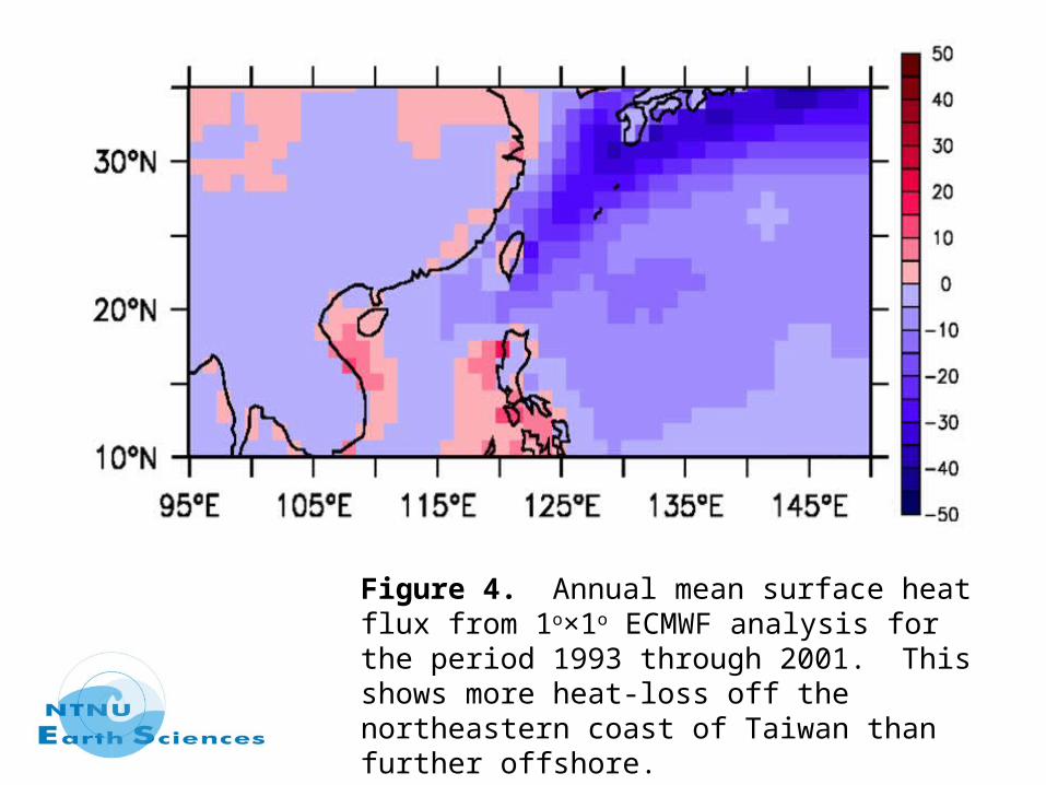
Figure 4. Annual mean surface heat flux from 1o×1o ECMWF analysis for the period 1993 through 2001. This shows more heat-loss off the northeastern coast of Taiwan than further offshore.
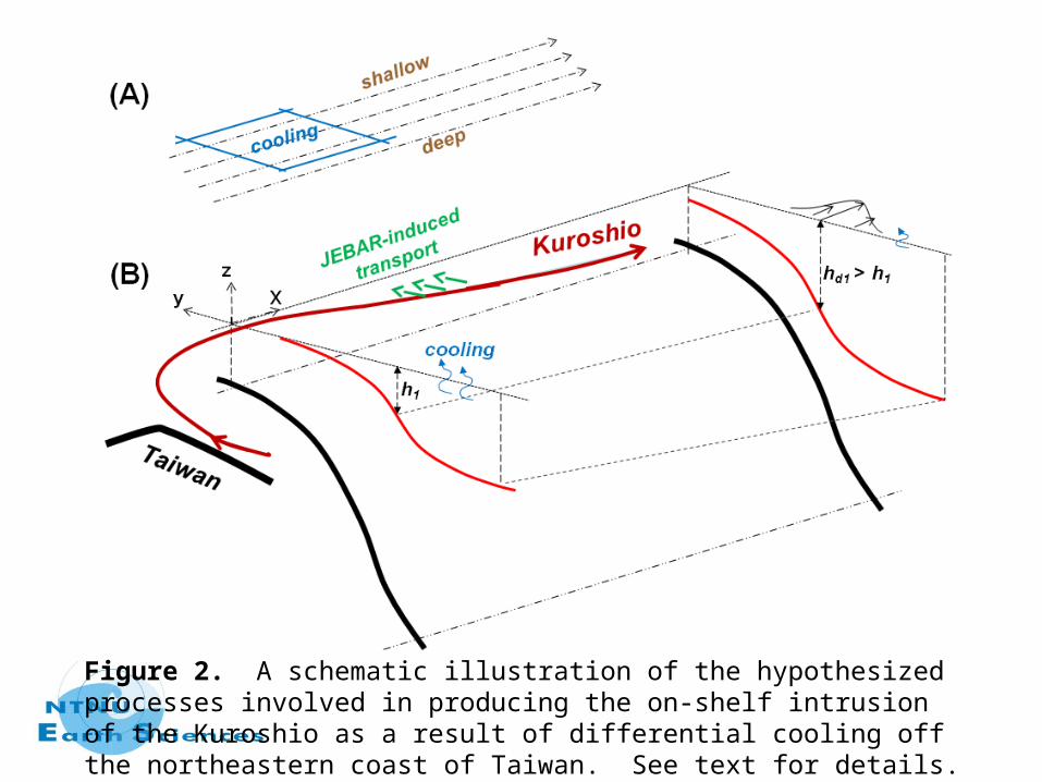
Figure 2. A schematic illustration of the hypothesized processes involved in producing the on-shelf intrusion of the Kuroshio as a result of differential cooling off the northeastern coast of Taiwan. See text for details.

Surface heat flux alone can explain the seasonal migration of the Kuroshio off northeast Taiwan.
Vorticity balance analysis: the stronger on-shelf, cross-isobath intrusion in winter is accounted for by the JEBAR (Joint Effect of Baroclinicity and Relief) term.
The stronger JEBAR arises because of the stronger along-isobath (i.e. approximately zonal) upper-layer density gradient induced by the differential cooling in winter.
Brief Summary III
For detail, see Oey, L.-Y., Y.-C. Hsin, and C.-R. Wu* (2010): Why does the Kuroshio northeast of Taiwan shift shelfward in winter? Ocean Dynamics, 60, 413–426, doi: 10.1007/s10236-009-0259-5.

(Hwang and Wu, JGR2004 )
Figure 3. Distribution of cyclonic eddies (crosses) and anticyclonic eddies (circles) found using T/P altimeter data (dotted lines) over the period March 24, 1995 to 16 October 2000.
Kuroshio and eddies in the Luzon Strait

Westward eddies Northward eddies (AVISO SSHA)
05-Nov 1997
12-Nov 1997
19-Nov 1997
26-Nov 1997
07-Jan 1998
14-Jan 1998
21-Jan 1998
28-Jan 1998

Jet-eddy interaction
PVJet = + ΔQJ /2, x > 0,
= - ΔQJ /2, x < 0,
PVEddy = ΔQE, r < REddy
= 0, r > REddy

Jet-eddy interaction
(e.g. Stern and Flierl, 1987; Bell, 1990;Chern et al., 2005)

Jet-eddy interaction
(e.g. Vandermeirsch et al., 2003a; 2003b)

Jet-eddy interaction

0 Month 1 Month 2 Months
0 Week 2 Weeks 4 Weeks
Vectors show the current, and the color shading represents the vorticity, unit : 10-5/s
The ensemble-averaged composites (0 ~ 150 m)

10-year time-series of modeled NEC bifurcation latitude (blue) and Kuroshio transport
The blocking pattern coincides with the period when the Kuroshio is more intense, with transport 30~35 Sv, and that the transport is weaker, about 18~22 Sv, during the westward-passage pattern.

Brief Summary IV Whether or not an eddy can pass through the Luzon Strait depends on(i) the strength of transport of the Kuroshio(ii) the curvature of the Kuroshio just north of the Luzon Island.
• Strong transports in summertime tend to produce a ‘leaping’ Kuroshio
• Appears in summer-like when the NEC shifts southward
• Weaker transports in wintertime tend to produce a westward ‘looping’ Kuroshio
• Appears in winter-like when the NEC shifts northward
Blocking mode Westward-passage mode

1998/121997/12
NEC during El Niño and La Niña
For detail, see Sheu, W.-J., C.-R. Wu*, and L. -Y. Oey (2010): Blocking and westward passage of eddies in the Luzon Strait. Deep Sea Research II, 57, 1783-1791, doi:10.1016/j.dsr2.2010.04.004.


![Ensemble forecast of the Kuroshio meanderingengan.cmes.ehime-u.ac.jp/xguo/paper/Miyazawa2005JGR.pdf · The theoretical studies [e.g., Masuda, 1982] suggest that the Kuroshio can possess](https://static.documents.pub/doc/80x56/5f971cd0bf26f91b450a9c6f/ensemble-forecast-of-the-kuroshio-the-theoretical-studies-eg-masuda-1982-suggest.jpg)


