The large Thaumasia graben on Mars: Is it a rift? E. Hauber Institute of Planetary Research, German Aerospace Center (DLR), Berlin, Germany P. Kronberg Institute of Geology and Paleontology, Technical University Clausthal, Clausthal-Zellerfeld, Germany Received 25 January 2005; revised 12 April 2005; accepted 22 April 2005; published 26 July 2005. [1] We investigate the morphology and topography of one of the largest fault-bounded tectonic structures on Mars, a complex, approximately N-S trending system of troughs and scarps at the western border of the Thaumasia plateau in the Claritas region (hereinafter referred to as ‘‘Thaumasia graben,’’ or TG). It is located between 15°S and 38°S latitude and at 255°E longitude. No detailed investigation of its morphotectonic setting has been performed yet. The region is a complexly fractured area with a number of different fault sets, including simple and complex graben. The TG extends over more than 1000 km along its trend, averaging 100 km in width and 1.6 km in depth. Crustal extension is accommodated by the formation of a system of asymmetric graben, or halfgraben. On the basis of fault orientation and trough depth, the TG can be subdivided in a north-south direction into three segments. Except for the northernmost segment, the predominant master fault system is located along the eastern flank of the TG, highlighting the overall asymmetric architecture. Fault length segments vary from 50 to 90 km with observable displacements of 1.3–2.2 km. Crustal extension, inferred from gridded MOLA topography across scarp offsets, varies along trend between 0.5 km and 4 km, assuming a fault dip of 60°. This is relatively moderate extension if compared to terrestrial continental rifts, but consistent with extension measured across the Tempe Rift on Mars. We find that the Thaumasia graben displays some characteristics which are common to terrestrial continental rifts, whereas other properties are distinctively not rift-like. Citation: Hauber, E., and P. Kronberg (2005), The large Thaumasia graben on Mars: Is it a rift?, J. Geophys. Res., 110, E07003, doi:10.1029/2005JE002407. 1. Introduction [2] The tectonics of the western hemisphere of Mars is dominated by the Tharsis bulge, a huge area of elevated topography characterized by volcanic materials. Two major groups of tectonic features of regional extent can be distinguished in the Tharsis region: A concentric set of wrinkle ridges indicating compression radial to Tharsis, and several sets of extensional features that radiate outward from different centers within Tharsis, indicating tension circumferential to Tharsis (Figure 1). The extensional fea- tures were explained by models that involve gravitational loading of the volcanic material, which induces isostatic stresses, flexural bending stresses and/or membrane stresses and subsequent deformation [e.g., Turcotte et al., 1981; Sleep and Phillips, 1985; Banerdt et al., 1992; Tanaka et al., 1991; Banerdt and Golombek, 2000]. Most of the exten- sional structures are long and narrow graben, which have widths of only a few kilometers and lengths of up to hundreds of kilometers. Graben sets of this kind are often thought to be surface expressions of giant dike swarms radiating outward from the Tharsis region [Me `ge and Masson, 1996a, 1996b; Ernst et al., 2001; Wilson and Head, 2002], although there are alternative explanations [Me `ge et al., 2003]. Some extensional features are, however, considerably more complex than simple graben. They consist of large and complex graben systems that occur in several locations within Tharsis. Examples of these more complex graben systems are the Tempe Fossae [Hauber and Kronberg, 2001], the Acheron Fossae north of Olympus Mons [Kronberg et al., 2004], the Coracis Fossae in the South Tharsis Ridge Belt in the Thaumasia province, and a large extensional feature in the Claritas Fossae region, which is the object of this study. They all range in width from tens to hundreds of kilometers, and in length from hundreds to thousands of kilometers. They are characterized by several border faults and deep, fractured graben floors. Even larger are the Valles Marineris, also radial to Tharsis and thought to be tectonically controlled. These complex graben have been described as rifts on the basis of Viking Orbiter images [e.g., Tanaka et al., 1991; Banerdt et al., 1992]. While most discussions about rifting on Mars have focussed on the Valles Marineris [e.g., Frey , 1979; Schoenfeld, 1979; Masson, 1977, 1980, 1985; Wood and Head, 1978; Schultz, 1991; Anderson and Grimm, 1998, JOURNAL OF GEOPHYSICAL RESEARCH, VOL. 110, E07003, doi:10.1029/2005JE002407, 2005 Copyright 2005 by the American Geophysical Union. 0148-0227/05/2005JE002407$09.00 E07003 1 of 13
Transcript
The large Thaumasia graben on Mars: Is it a rift?
E. HauberInstitute of Planetary Research, German Aerospace Center (DLR), Berlin, Germany
P. KronbergInstitute of Geology and Paleontology, Technical University Clausthal, Clausthal-Zellerfeld, Germany
Received 25 January 2005; revised 12 April 2005; accepted 22 April 2005; published 26 July 2005.
[1] We investigate the morphology and topography of one of the largest fault-boundedtectonic structures on Mars, a complex, approximately N-S trending system of troughsand scarps at the western border of the Thaumasia plateau in the Claritas region(hereinafter referred to as ‘‘Thaumasia graben,’’ or TG). It is located between 15�S and38�S latitude and at �255�E longitude. No detailed investigation of its morphotectonicsetting has been performed yet. The region is a complexly fractured area with a number ofdifferent fault sets, including simple and complex graben. The TG extends over morethan 1000 km along its trend, averaging 100 km in width and 1.6 km in depth. Crustalextension is accommodated by the formation of a system of asymmetric graben, orhalfgraben. On the basis of fault orientation and trough depth, the TG can be subdivided ina north-south direction into three segments. Except for the northernmost segment, thepredominant master fault system is located along the eastern flank of the TG, highlightingthe overall asymmetric architecture. Fault length segments vary from 50 to 90 km withobservable displacements of 1.3–2.2 km. Crustal extension, inferred from gridded MOLAtopography across scarp offsets, varies along trend between 0.5 km and �4 km, assuminga fault dip of 60�. This is relatively moderate extension if compared to terrestrialcontinental rifts, but consistent with extension measured across the Tempe Rift on Mars.We find that the Thaumasia graben displays some characteristics which are common toterrestrial continental rifts, whereas other properties are distinctively not rift-like.
Citation: Hauber, E., and P. Kronberg (2005), The large Thaumasia graben on Mars: Is it a rift?, J. Geophys. Res., 110, E07003,
doi:10.1029/2005JE002407.
1. Introduction
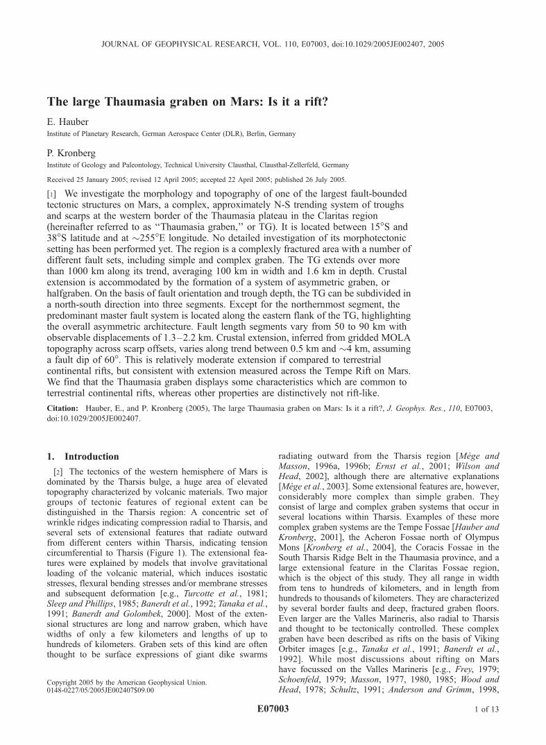
[2] The tectonics of the western hemisphere of Mars isdominated by the Tharsis bulge, a huge area of elevatedtopography characterized by volcanic materials. Two majorgroups of tectonic features of regional extent can bedistinguished in the Tharsis region: A concentric set ofwrinkle ridges indicating compression radial to Tharsis, andseveral sets of extensional features that radiate outwardfrom different centers within Tharsis, indicating tensioncircumferential to Tharsis (Figure 1). The extensional fea-tures were explained by models that involve gravitationalloading of the volcanic material, which induces isostaticstresses, flexural bending stresses and/or membrane stressesand subsequent deformation [e.g., Turcotte et al., 1981;Sleep and Phillips, 1985; Banerdt et al., 1992; Tanaka et al.,1991; Banerdt and Golombek, 2000]. Most of the exten-sional structures are long and narrow graben, which havewidths of only a few kilometers and lengths of up tohundreds of kilometers. Graben sets of this kind are oftenthought to be surface expressions of giant dike swarms
radiating outward from the Tharsis region [Mege andMasson, 1996a, 1996b; Ernst et al., 2001; Wilson andHead, 2002], although there are alternative explanations[Mege et al., 2003]. Some extensional features are, however,considerably more complex than simple graben. Theyconsist of large and complex graben systems that occur inseveral locations within Tharsis. Examples of these morecomplex graben systems are the Tempe Fossae [Hauber andKronberg, 2001], the Acheron Fossae north of OlympusMons [Kronberg et al., 2004], the Coracis Fossae in theSouth Tharsis Ridge Belt in the Thaumasia province, and alarge extensional feature in the Claritas Fossae region,which is the object of this study. They all range in widthfrom tens to hundreds of kilometers, and in length fromhundreds to thousands of kilometers. They are characterizedby several border faults and deep, fractured graben floors.Even larger are the Valles Marineris, also radial to Tharsisand thought to be tectonically controlled. These complexgraben have been described as rifts on the basis of VikingOrbiter images [e.g., Tanaka et al., 1991; Banerdt et al.,1992]. While most discussions about rifting on Marshave focussed on the Valles Marineris [e.g., Frey, 1979;Schoenfeld, 1979; Masson, 1977, 1980, 1985; Wood andHead, 1978; Schultz, 1991; Anderson and Grimm, 1998,
JOURNAL OF GEOPHYSICAL RESEARCH, VOL. 110, E07003, doi:10.1029/2005JE002407, 2005
Copyright 2005 by the American Geophysical Union.0148-0227/05/2005JE002407$09.00
E07003 1 of 13
1999; Anderson et al., 1999; Barnett and Nimmo, 2002;Komatsu, 2003], the Tempe Fossae are a better analog toterrestrial continental rifts from a morphological and struc-tural point of view [Hauber and Kronberg, 2001]. Here weinvestigate the characteristics of the largest extensionalstructure in the Claritas Fossae region (western Thaumasia)on the basis of Viking Orbiter images and MOLA topo-graphic data. Several authors [e.g., Plescia and Saunders,1982; Tanaka and Davis, 1988; Tanaka et al., 1991;Banerdt et al., 1992] ascribe its origin to rifting, due to itslarge dimensions, the existence of multiple border faults,deeper and multiply faulted floors, and possible failure ofthe entire lithosphere. Roof collapse after a late-stagemagma withdrawal from a Syria Planum magma chamberhas also been hypothesized as a mechanism to create thescarp that is associated with the Thaumasia graben, basedon its morphologic similarity with the great Mauna Loascarp [Mege and Masson, 1996b]. Our study follows theapproach we previously used to characterize the TempeFossae Rift [Hauber and Kronberg, 2001]. We describe themorphology and topography of the Thaumasia graben anddiscuss its tectonic style and possible causative magmatec-tonic processes.
2. Geography
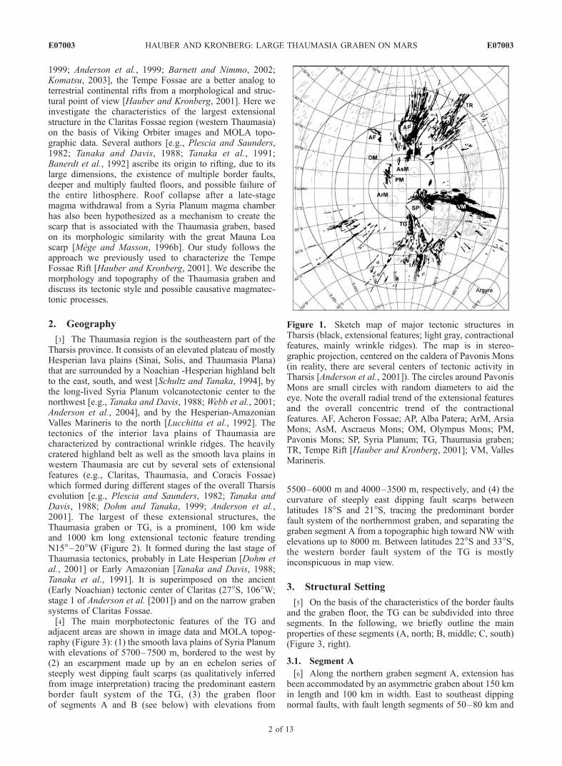
[3] The Thaumasia region is the southeastern part of theTharsis province. It consists of an elevated plateau of mostlyHesperian lava plains (Sinai, Solis, and Thaumasia Plana)that are surrounded by a Noachian -Hesperian highland beltto the east, south, and west [Schultz and Tanaka, 1994], bythe long-lived Syria Planum volcanotectonic center to thenorthwest [e.g., Tanaka and Davis, 1988; Webb et al., 2001;Anderson et al., 2004], and by the Hesperian-AmazonianValles Marineris to the north [Lucchitta et al., 1992]. Thetectonics of the interior lava plains of Thaumasia arecharacterized by contractional wrinkle ridges. The heavilycratered highland belt as well as the smooth lava plains inwestern Thaumasia are cut by several sets of extensionalfeatures (e.g., Claritas, Thaumasia, and Coracis Fossae)which formed during different stages of the overall Tharsisevolution [e.g., Plescia and Saunders, 1982; Tanaka andDavis, 1988; Dohm and Tanaka, 1999; Anderson et al.,2001]. The largest of these extensional structures, theThaumasia graben or TG, is a prominent, 100 km wideand 1000 km long extensional tectonic feature trendingN15�–20�W (Figure 2). It formed during the last stage ofThaumasia tectonics, probably in Late Hesperian [Dohm etal., 2001] or Early Amazonian [Tanaka and Davis, 1988;Tanaka et al., 1991]. It is superimposed on the ancient(Early Noachian) tectonic center of Claritas (27�S, 106�W;stage 1 of Anderson et al. [2001]) and on the narrow grabensystems of Claritas Fossae.[4] The main morphotectonic features of the TG and
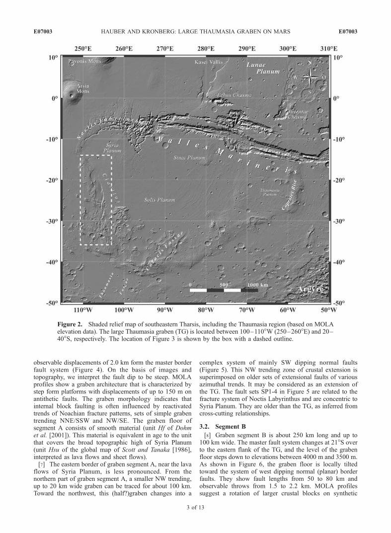
adjacent areas are shown in image data and MOLA topog-raphy (Figure 3): (1) the smooth lava plains of Syria Planumwith elevations of 5700–7500 m, bordered to the west by(2) an escarpment made up by an en echelon series ofsteeply west dipping fault scarps (as qualitatively inferredfrom image interpretation) tracing the predominant easternborder fault system of the TG, (3) the graben floorof segments A and B (see below) with elevations from
5500–6000 m and 4000–3500 m, respectively, and (4) thecurvature of steeply east dipping fault scarps betweenlatitudes 18�S and 21�S, tracing the predominant borderfault system of the northernmost graben, and separating thegraben segment A from a topographic high toward NW withelevations up to 8000 m. Between latitudes 22�S and 33�S,the western border fault system of the TG is mostlyinconspicuous in map view.
3. Structural Setting
[5] On the basis of the characteristics of the border faultsand the graben floor, the TG can be subdivided into threesegments. In the following, we briefly outline the mainproperties of these segments (A, north; B, middle; C, south)(Figure 3, right).
3.1. Segment A
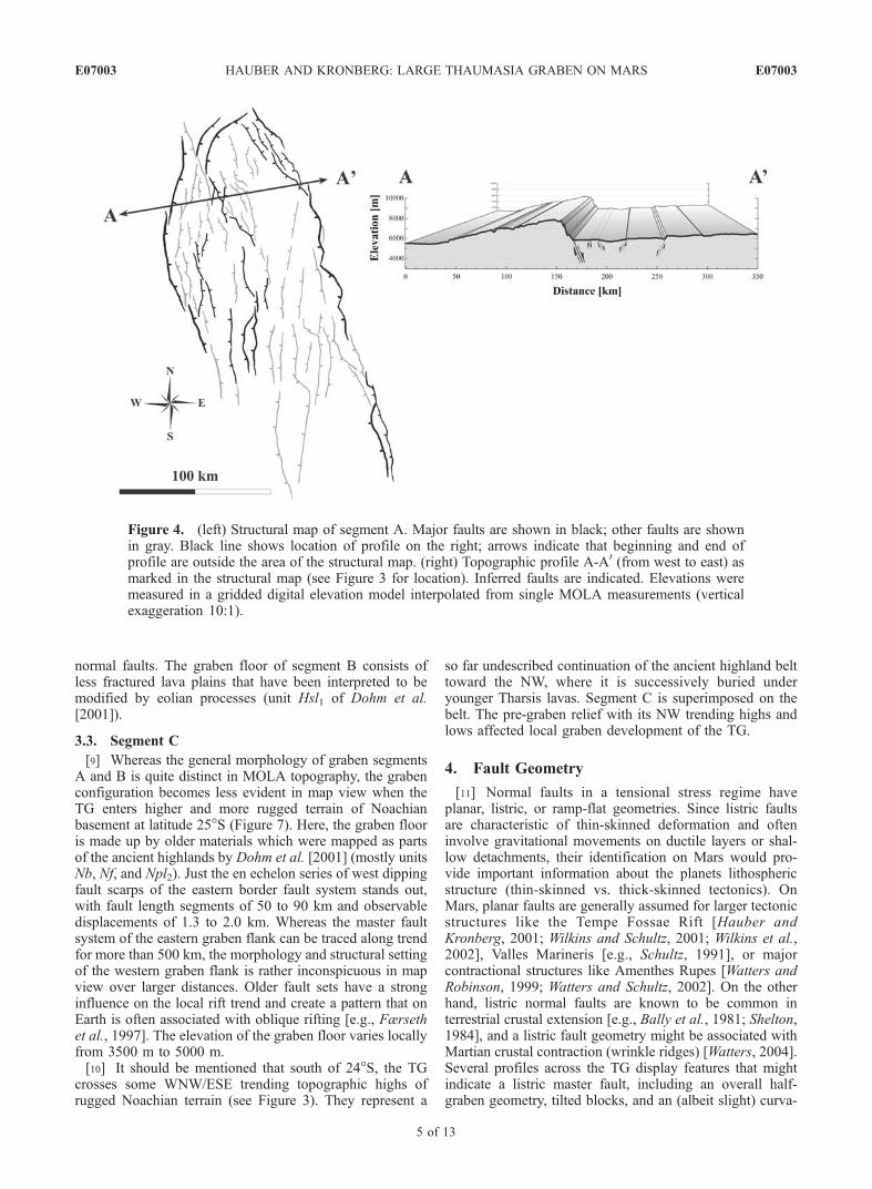
[6] Along the northern graben segment A, extension hasbeen accommodated by an asymmetric graben about 150 kmin length and 100 km in width. East to southeast dippingnormal faults, with fault length segments of 50–80 km and
Figure 1. Sketch map of major tectonic structures inTharsis (black, extensional features; light gray, contractionalfeatures, mainly wrinkle ridges). The map is in stereo-graphic projection, centered on the caldera of Pavonis Mons(in reality, there are several centers of tectonic activity inTharsis [Anderson et al., 2001]). The circles around PavonisMons are small circles with random diameters to aid theeye. Note the overall radial trend of the extensional featuresand the overall concentric trend of the contractionalfeatures. AF, Acheron Fossae; AP, Alba Patera; ArM, ArsiaMons; AsM, Ascraeus Mons; OM, Olympus Mons; PM,Pavonis Mons; SP, Syria Planum; TG, Thaumasia graben;TR, Tempe Rift [Hauber and Kronberg, 2001]; VM, VallesMarineris.
E07003 HAUBER AND KRONBERG: LARGE THAUMASIA GRABEN ON MARS
2 of 13
E07003
observable displacements of 2.0 km form the master borderfault system (Figure 4). On the basis of images andtopography, we interpret the fault dip to be steep. MOLAprofiles show a graben architecture that is characterized bystep form platforms with displacements of up to 150 m onantithetic faults. The graben morphology indicates thatinternal block faulting is often influenced by reactivatedtrends of Noachian fracture patterns, sets of simple grabentrending NNE/SSW and NW/SE. The graben floor ofsegment A consists of smooth material (unit Hf of Dohmet al. [2001]). This material is equivalent in age to the unitthat covers the broad topographic high of Syria Planum(unit Hsu of the global map of Scott and Tanaka [1986],interpreted as lava flows and sheet flows).[7] The eastern border of graben segment A, near the lava
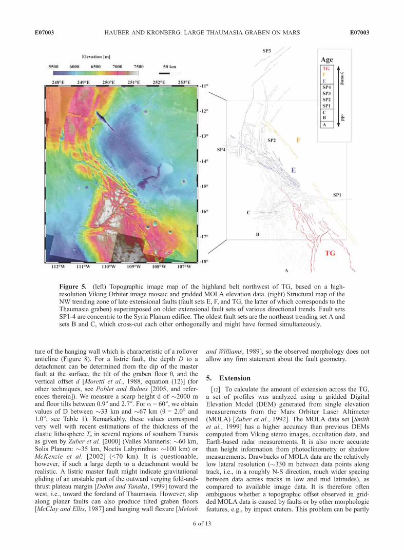
flows of Syria Planum, is less pronounced. From thenorthern part of graben segment A, a smaller NW trending,up to 20 km wide graben can be traced for about 100 km.Toward the northwest, this (half?)graben changes into a
complex system of mainly SW dipping normal faults(Figure 5). This NW trending zone of crustal extension issuperimposed on older sets of extensional faults of variousazimuthal trends. It may be considered as an extension ofthe TG. The fault sets SP1-4 in Figure 5 are related to thefracture system of Noctis Labyrinthus and are concentric toSyria Planum. They are older than the TG, as inferred fromcross-cutting relationships.
3.2. Segment B
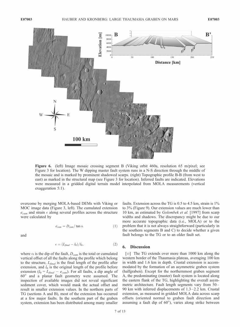
[8] Graben segment B is about 250 km long and up to100 km wide. The master fault system changes at 21�S overto the eastern flank of the TG, and the level of the grabenfloor steps down to elevations between 4000 m and 3500 m.As shown in Figure 6, the graben floor is locally tiltedtoward the system of west dipping normal (planar) borderfaults. They show fault lengths from 50 to 80 km andobservable throws from 1.5 to 2.2 km. MOLA profilessuggest a rotation of larger crustal blocks on synthetic
Figure 2. Shaded relief map of southeastern Tharsis, including the Thaumasia region (based on MOLAelevation data). The large Thaumasia graben (TG) is located between 100–110�W (250–260�E) and 20–40�S, respectively. The location of Figure 3 is shown by the box with a dashed outline.
E07003 HAUBER AND KRONBERG: LARGE THAUMASIA GRABEN ON MARS
3 of 13
E07003
Figure 3. (left) Topographic image map of the large Thaumasia graben (TG) (see Figure 2 for location).The map is a combination of MOC wide-angle images and a gridded digital elevation model based onMOLA measurements. The locations of topographic profiles shown in Figures 4, 6, and 7 are markedwith dashed lines, and the location of Figure 6 is marked by solid white lines. (right) Structural sketchmap of the TG, showing the major faults and the subdivision into three segments A, B, and C.
E07003 HAUBER AND KRONBERG: LARGE THAUMASIA GRABEN ON MARS
4 of 13
E07003
normal faults. The graben floor of segment B consists ofless fractured lava plains that have been interpreted to bemodified by eolian processes (unit Hsl1 of Dohm et al.[2001]).
3.3. Segment C
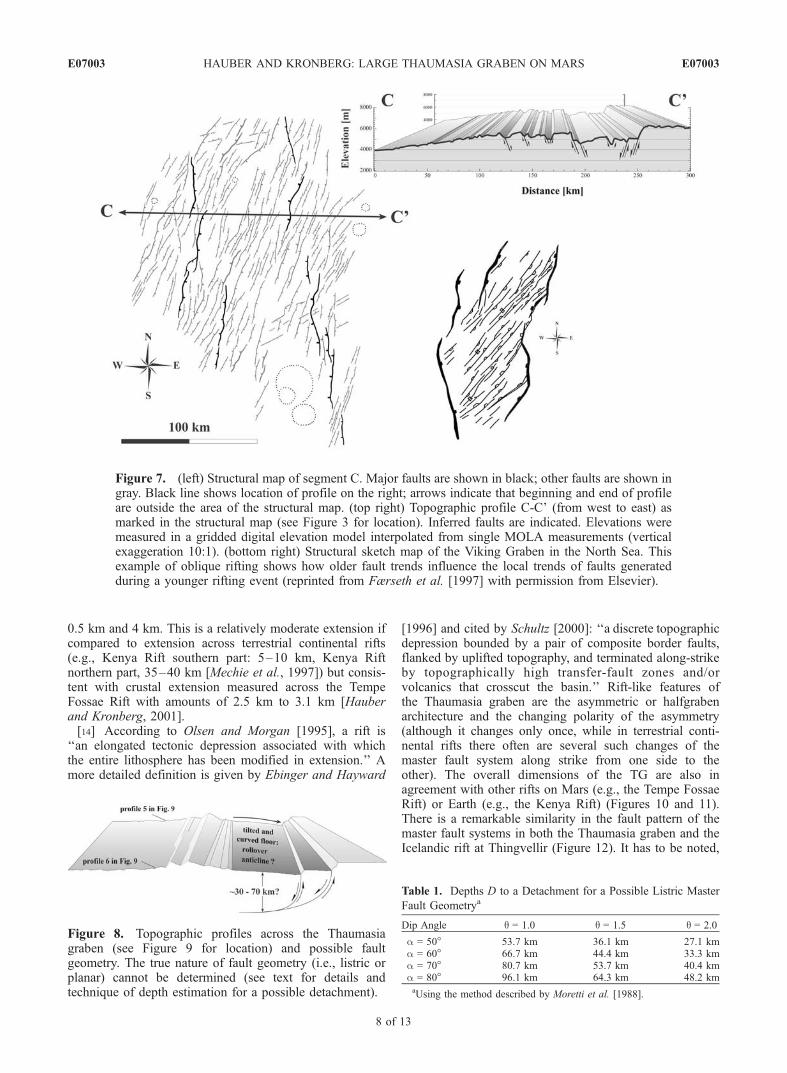
[9] Whereas the general morphology of graben segmentsA and B is quite distinct in MOLA topography, the grabenconfiguration becomes less evident in map view when theTG enters higher and more rugged terrain of Noachianbasement at latitude 25�S (Figure 7). Here, the graben flooris made up by older materials which were mapped as partsof the ancient highlands by Dohm et al. [2001] (mostly unitsNb, Nf, and Npl2). Just the en echelon series of west dippingfault scarps of the eastern border fault system stands out,with fault length segments of 50 to 90 km and observabledisplacements of 1.3 to 2.0 km. Whereas the master faultsystem of the eastern graben flank can be traced along trendfor more than 500 km, the morphology and structural settingof the western graben flank is rather inconspicuous in mapview over larger distances. Older fault sets have a stronginfluence on the local rift trend and create a pattern that onEarth is often associated with oblique rifting [e.g., Færsethet al., 1997]. The elevation of the graben floor varies locallyfrom 3500 m to 5000 m.[10] It should be mentioned that south of 24�S, the TG
crosses some WNW/ESE trending topographic highs ofrugged Noachian terrain (see Figure 3). They represent a
so far undescribed continuation of the ancient highland belttoward the NW, where it is successively buried underyounger Tharsis lavas. Segment C is superimposed on thebelt. The pre-graben relief with its NW trending highs andlows affected local graben development of the TG.
4. Fault Geometry
[11] Normal faults in a tensional stress regime haveplanar, listric, or ramp-flat geometries. Since listric faultsare characteristic of thin-skinned deformation and ofteninvolve gravitational movements on ductile layers or shal-low detachments, their identification on Mars would pro-vide important information about the planets lithosphericstructure (thin-skinned vs. thick-skinned tectonics). OnMars, planar faults are generally assumed for larger tectonicstructures like the Tempe Fossae Rift [Hauber andKronberg, 2001; Wilkins and Schultz, 2001; Wilkins et al.,2002], Valles Marineris [e.g., Schultz, 1991], or majorcontractional structures like Amenthes Rupes [Watters andRobinson, 1999; Watters and Schultz, 2002]. On the otherhand, listric normal faults are known to be common interrestrial crustal extension [e.g., Bally et al., 1981; Shelton,1984], and a listric fault geometry might be associated withMartian crustal contraction (wrinkle ridges) [Watters, 2004].Several profiles across the TG display features that mightindicate a listric master fault, including an overall half-graben geometry, tilted blocks, and an (albeit slight) curva-
Figure 4. (left) Structural map of segment A. Major faults are shown in black; other faults are shownin gray. Black line shows location of profile on the right; arrows indicate that beginning and end ofprofile are outside the area of the structural map. (right) Topographic profile A-A0 (from west to east) asmarked in the structural map (see Figure 3 for location). Inferred faults are indicated. Elevations weremeasured in a gridded digital elevation model interpolated from single MOLA measurements (verticalexaggeration 10:1).
E07003 HAUBER AND KRONBERG: LARGE THAUMASIA GRABEN ON MARS
5 of 13
E07003
ture of the hanging wall which is characteristic of a rolloveranticline (Figure 8). For a listric fault, the depth D to adetachment can be determined from the dip of the masterfault at the surface, the tilt of the graben floor q, and thevertical offset d [Moretti et al., 1988, equation (12)] (forother techniques, see Poblet and Bulnes [2005, and refer-ences therein]). We measure a scarp height d of �2000 mand floor tilts between 0.9� and 2.7�. For a = 60�, we obtainvalues of D between �33 km and �67 km (q = 2.0� and1.0�; see Table 1). Remarkably, these values correspondvery well with recent estimations of the thickness of theelastic lithosphere Te in several regions of southern Tharsisas given by Zuber et al. [2000] (Valles Marineris: �60 km,Solis Planum: �35 km, Noctis Labyrinthus: �100 km) orMcKenzie et al. [2002] (<70 km). It is questionable,however, if such a large depth to a detachment would berealistic. A listric master fault might indicate gravitationalgliding of an unstable part of the outward verging fold-and-thrust plateau margin [Dohm and Tanaka, 1999] toward thewest, i.e., toward the foreland of Thaumasia. However, slipalong planar faults can also produce tilted graben floors[McClay and Ellis, 1987] and hanging wall flexure [Melosh
and Williams, 1989], so the observed morphology does notallow any firm statement about the fault geometry.
5. Extension
[12] To calculate the amount of extension across the TG,a set of profiles was analyzed using a gridded DigitalElevation Model (DEM) generated from single elevationmeasurements from the Mars Orbiter Laser Altimeter(MOLA) [Zuber et al., 1992]. The MOLA data set [Smithet al., 1999] has a higher accuracy than previous DEMscomputed from Viking stereo images, occultation data, andEarth-based radar measurements. It is also more accuratethan height information from photoclinometry or shadowmeasurements. Drawbacks of MOLA data are the relativelylow lateral resolution (�330 m between data points alongtrack, i.e., in a roughly N-S direction, much wider spacingbetween data across tracks in low and mid latitudes), ascompared to available image data. It is therefore oftenambiguous whether a topographic offset observed in grid-ded MOLA data is caused by faults or by other morphologicfeatures, e.g., by impact craters. This problem can be partly
Figure 5. (left) Topographic image map of the highland belt northwest of TG, based on a high-resolution Viking Orbiter image mosaic and gridded MOLA elevation data. (right) Structural map of theNW trending zone of late extensional faults (fault sets E, F, and TG, the latter of which corresponds to theThaumasia graben) superimposed on older extensional fault sets of various directional trends. Fault setsSP1-4 are concentric to the Syria Planum edifice. The oldest fault sets are the northeast trending set A andsets B and C, which cross-cut each other orthogonally and might have formed simultaneously.
E07003 HAUBER AND KRONBERG: LARGE THAUMASIA GRABEN ON MARS
6 of 13
E07003
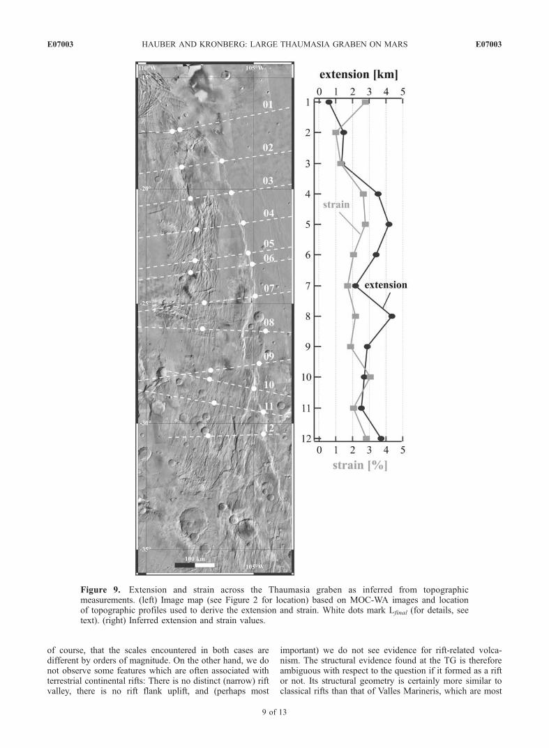
overcome by merging MOLA-based DEMs with Viking orMOC image data (Figure 3, left). The cumulated extensionecum and strain � along several profiles across the structurewere calculated by
ecum ¼ Dcum= tana ð1Þ
and
� ¼ ðLfinal � l0Þ=l0; ð2Þ
where a is the dip of the fault, Dcum is the total or cumulatedvertical offset of all the faults along the profile which belongto the structure, Lfinal is the final length of the profile afterextension, and l0 is the original length of the profile beforeextension (l0 = Lfinal � ecum). For all faults, a dip angle of60� and a planar fault geometry were assumed. Theinspection of available images did not reveal significantsediment cover, which would mask the actual offset andresult in smaller extension values. In the northern parts ofTG (sections A and B), most of the extension has occurredat a few major faults. In the southern part of the grabensystem, extension has been distributed among many smaller
faults. Extension across the TG is 0.5 to 4.5 km, strain is 1%to 3% (Figure 9). Our extension values are much lower than10 km, as estimated by Golombek et al. [1997] from scarpwidths and shadows. The discrepancy might be due to ourmore accurate topographic data (i.e., MOLA) or to theproblem that it is not always straightforward (particularly inthe southern segments B and C) to decide whether a givenfault belongs to the TG or to an older fault set.
6. Discussion
[13] The TG extends over more than 1000 km along thewestern border of the Thaumasia plateau, averaging 100 kmin width and 1.6 km in depth. Crustal extension is accom-modated by the formation of an asymmetric graben system(halfgraben). Except for the northernmost graben segmentA, the predominating (master) fault system is located alongthe eastern flank of the TG, highlighting the overall asym-metric architecture. Fault length segments vary from 50–90 km with inferred displacements of 1.3–2.2 km. Crustalextension, as measured in gridded MOLA data across scarpoffsets (oriented normal to graben fault direction andassuming a fault dip of 60�), varies along strike between
Figure 6. (left) Image mosaic crossing segment B (Viking orbit 460a, resolution 65 m/pixel; seeFigure 3 for location). The W dipping master fault system runs in a N-S direction through the middle ofthe mosaic and is marked by prominent shadowed scarps. (right) Topographic profile B-B (from west toeast) as marked in the structural map (see Figure 3 for location). Inferred faults are indicated. Elevationswere measured in a gridded digital terrain model interpolated from MOLA measurements (verticalexaggeration 5:1).
E07003 HAUBER AND KRONBERG: LARGE THAUMASIA GRABEN ON MARS
7 of 13
E07003
0.5 km and 4 km. This is a relatively moderate extension ifcompared to extension across terrestrial continental rifts(e.g., Kenya Rift southern part: 5–10 km, Kenya Riftnorthern part, 35–40 km [Mechie et al., 1997]) but consis-tent with crustal extension measured across the TempeFossae Rift with amounts of 2.5 km to 3.1 km [Hauberand Kronberg, 2001].[14] According to Olsen and Morgan [1995], a rift is
‘‘an elongated tectonic depression associated with whichthe entire lithosphere has been modified in extension.’’ Amore detailed definition is given by Ebinger and Hayward
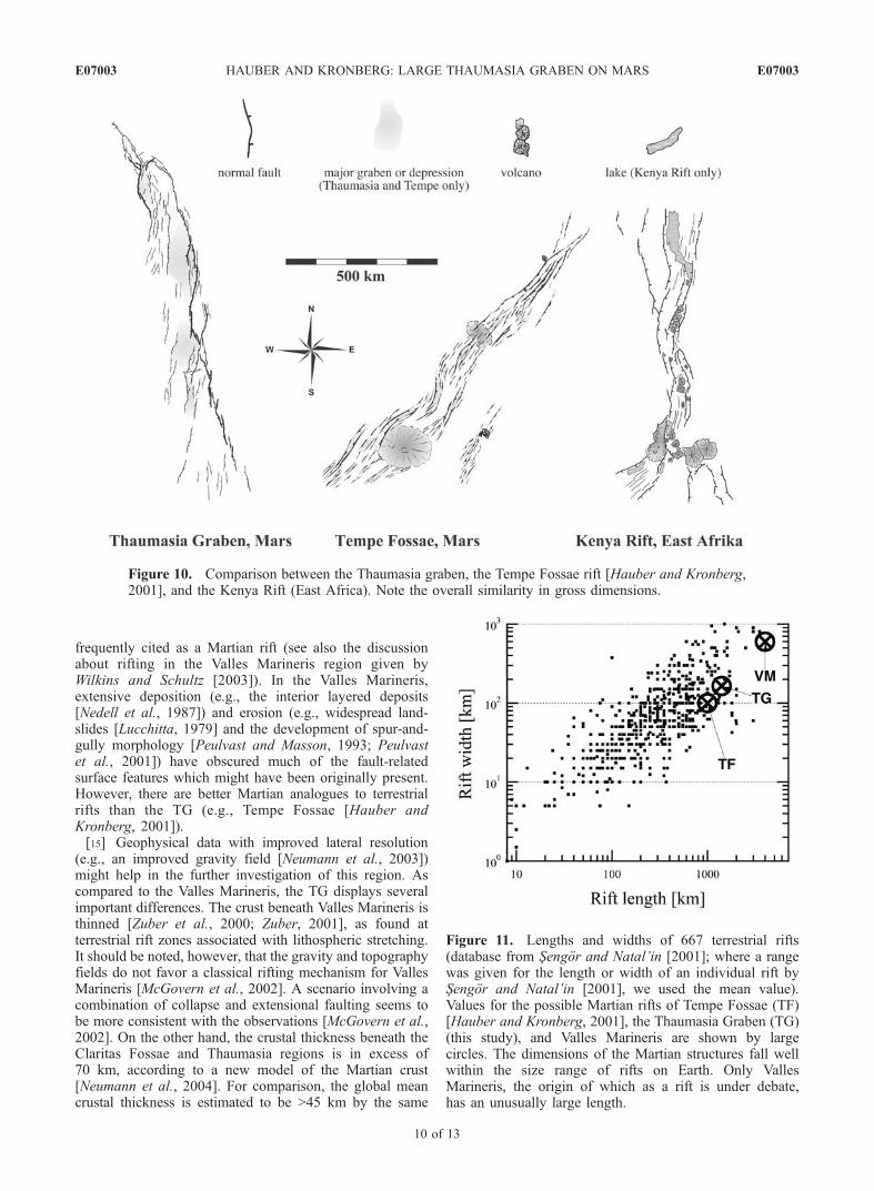
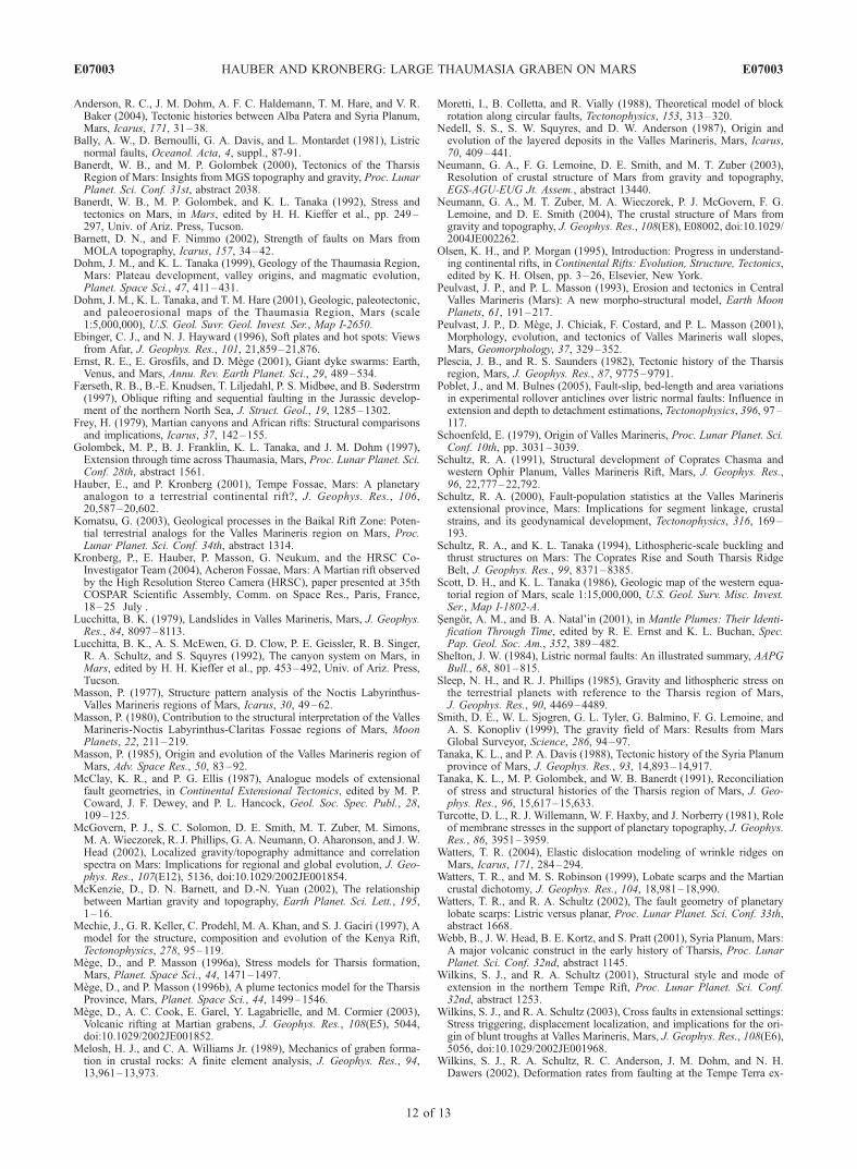
[1996] and cited by Schultz [2000]: ‘‘a discrete topographicdepression bounded by a pair of composite border faults,flanked by uplifted topography, and terminated along-strikeby topographically high transfer-fault zones and/orvolcanics that crosscut the basin.’’ Rift-like features ofthe Thaumasia graben are the asymmetric or halfgrabenarchitecture and the changing polarity of the asymmetry(although it changes only once, while in terrestrial conti-nental rifts there often are several such changes of themaster fault system along strike from one side to theother). The overall dimensions of the TG are also inagreement with other rifts on Mars (e.g., the Tempe FossaeRift) or Earth (e.g., the Kenya Rift) (Figures 10 and 11).There is a remarkable similarity in the fault pattern of themaster fault systems in both the Thaumasia graben and theIcelandic rift at Thingvellir (Figure 12). It has to be noted,
Figure 7. (left) Structural map of segment C. Major faults are shown in black; other faults are shown ingray. Black line shows location of profile on the right; arrows indicate that beginning and end of profileare outside the area of the structural map. (top right) Topographic profile C-C’ (from west to east) asmarked in the structural map (see Figure 3 for location). Inferred faults are indicated. Elevations weremeasured in a gridded digital elevation model interpolated from single MOLA measurements (verticalexaggeration 10:1). (bottom right) Structural sketch map of the Viking Graben in the North Sea. Thisexample of oblique rifting shows how older fault trends influence the local trends of faults generatedduring a younger rifting event (reprinted from Færseth et al. [1997] with permission from Elsevier).
Figure 8. Topographic profiles across the Thaumasiagraben (see Figure 9 for location) and possible faultgeometry. The true nature of fault geometry (i.e., listric orplanar) cannot be determined (see text for details andtechnique of depth estimation for a possible detachment).
Table 1. Depths D to a Detachment for a Possible Listric Master
Fault Geometrya
Dip Angle q = 1.0 q = 1.5 q = 2.0
a = 50� 53.7 km 36.1 km 27.1 kma = 60� 66.7 km 44.4 km 33.3 kma = 70� 80.7 km 53.7 km 40.4 kma = 80� 96.1 km 64.3 km 48.2 kmaUsing the method described by Moretti et al. [1988].
E07003 HAUBER AND KRONBERG: LARGE THAUMASIA GRABEN ON MARS
8 of 13
E07003
of course, that the scales encountered in both cases aredifferent by orders of magnitude. On the other hand, we donot observe some features which are often associated withterrestrial continental rifts: There is no distinct (narrow) riftvalley, there is no rift flank uplift, and (perhaps most
important) we do not see evidence for rift-related volca-nism. The structural evidence found at the TG is thereforeambiguous with respect to the question if it formed as a riftor not. Its structural geometry is certainly more similar toclassical rifts than that of Valles Marineris, which are most
Figure 9. Extension and strain across the Thaumasia graben as inferred from topographicmeasurements. (left) Image map (see Figure 2 for location) based on MOC-WA images and locationof topographic profiles used to derive the extension and strain. White dots mark Lfinal (for details, seetext). (right) Inferred extension and strain values.
E07003 HAUBER AND KRONBERG: LARGE THAUMASIA GRABEN ON MARS
9 of 13
E07003
frequently cited as a Martian rift (see also the discussionabout rifting in the Valles Marineris region given byWilkins and Schultz [2003]). In the Valles Marineris,extensive deposition (e.g., the interior layered deposits[Nedell et al., 1987]) and erosion (e.g., widespread land-slides [Lucchitta, 1979] and the development of spur-and-gully morphology [Peulvast and Masson, 1993; Peulvastet al., 2001]) have obscured much of the fault-relatedsurface features which might have been originally present.However, there are better Martian analogues to terrestrialrifts than the TG (e.g., Tempe Fossae [Hauber andKronberg, 2001]).[15] Geophysical data with improved lateral resolution
(e.g., an improved gravity field [Neumann et al., 2003])might help in the further investigation of this region. Ascompared to the Valles Marineris, the TG displays severalimportant differences. The crust beneath Valles Marineris isthinned [Zuber et al., 2000; Zuber, 2001], as found atterrestrial rift zones associated with lithospheric stretching.It should be noted, however, that the gravity and topographyfields do not favor a classical rifting mechanism for VallesMarineris [McGovern et al., 2002]. A scenario involving acombination of collapse and extensional faulting seems tobe more consistent with the observations [McGovern et al.,2002]. On the other hand, the crustal thickness beneath theClaritas Fossae and Thaumasia regions is in excess of70 km, according to a new model of the Martian crust[Neumann et al., 2004]. For comparison, the global meancrustal thickness is estimated to be >45 km by the same
Figure 10. Comparison between the Thaumasia graben, the Tempe Fossae rift [Hauber and Kronberg,2001], and the Kenya Rift (East Africa). Note the overall similarity in gross dimensions.
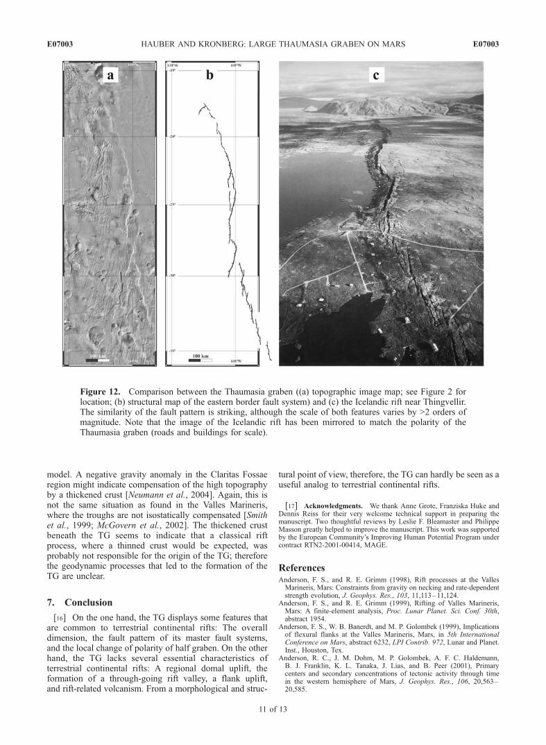
Figure 11. Lengths and widths of 667 terrestrial rifts(database from Sengor and Natal’in [2001]; where a rangewas given for the length or width of an individual rift bySengor and Natal’in [2001], we used the mean value).Values for the possible Martian rifts of Tempe Fossae (TF)[Hauber and Kronberg, 2001], the Thaumasia Graben (TG)(this study), and Valles Marineris are shown by largecircles. The dimensions of the Martian structures fall wellwithin the size range of rifts on Earth. Only VallesMarineris, the origin of which as a rift is under debate,has an unusually large length.
E07003 HAUBER AND KRONBERG: LARGE THAUMASIA GRABEN ON MARS
10 of 13
E07003
model. A negative gravity anomaly in the Claritas Fossaeregion might indicate compensation of the high topographyby a thickened crust [Neumann et al., 2004]. Again, this isnot the same situation as found in the Valles Marineris,where the troughs are not isostatically compensated [Smithet al., 1999; McGovern et al., 2002]. The thickened crustbeneath the TG seems to indicate that a classical riftprocess, where a thinned crust would be expected, wasprobably not responsible for the origin of the TG; thereforethe geodynamic processes that led to the formation of theTG are unclear.
7. Conclusion
[16] On the one hand, the TG displays some features thatare common to terrestrial continental rifts: The overalldimension, the fault pattern of its master fault systems,and the local change of polarity of half graben. On the otherhand, the TG lacks several essential characteristics ofterrestrial continental rifts: A regional domal uplift, theformation of a through-going rift valley, a flank uplift,and rift-related volcanism. From a morphological and struc-
tural point of view, therefore, the TG can hardly be seen as auseful analog to terrestrial continental rifts.
[17] Acknowledgments. We thank Anne Grote, Franziska Huke andDennis Reiss for their very welcome technical support in preparing themanuscript. Two thoughtful reviews by Leslie F. Bleamaster and PhilippeMasson greatly helped to improve the manuscript. This work was supportedby the European Community’s Improving Human Potential Program undercontract RTN2-2001-00414, MAGE.
ReferencesAnderson, F. S., and R. E. Grimm (1998), Rift processes at the VallesMarineris, Mars: Constraints from gravity on necking and rate-dependentstrength evolution, J. Geophys. Res., 103, 11,113–11,124.
Anderson, F. S., and R. E. Grimm (1999), Rifting of Valles Marineris,Mars: A finite-element analysis, Proc. Lunar Planet. Sci. Conf. 30th,abstract 1954.
Anderson, F. S., W. B. Banerdt, and M. P. Golombek (1999), Implicationsof flexural flanks at the Valles Marineris, Mars, in 5th InternationalConference on Mars, abstract 6232, LPI Contrib. 972, Lunar and Planet.Inst., Houston, Tex.
Anderson, R. C., J. M. Dohm, M. P. Golombek, A. F. C. Haldemann,B. J. Franklin, K. L. Tanaka, J. Lias, and B. Peer (2001), Primarycenters and secondary concentrations of tectonic activity through timein the western hemisphere of Mars, J. Geophys. Res., 106, 20,563–20,585.
Figure 12. Comparison between the Thaumasia graben ((a) topographic image map; see Figure 2 forlocation; (b) structural map of the eastern border fault system) and (c) the Icelandic rift near Thingvellir.The similarity of the fault pattern is striking, although the scale of both features varies by >2 orders ofmagnitude. Note that the image of the Icelandic rift has been mirrored to match the polarity of theThaumasia graben (roads and buildings for scale).
E07003 HAUBER AND KRONBERG: LARGE THAUMASIA GRABEN ON MARS
11 of 13
E07003
Anderson, R. C., J. M. Dohm, A. F. C. Haldemann, T. M. Hare, and V. R.Baker (2004), Tectonic histories between Alba Patera and Syria Planum,Mars, Icarus, 171, 31–38.
Bally, A. W., D. Bernoulli, G. A. Davis, and L. Montardet (1981), Listricnormal faults, Oceanol. Acta, 4, suppl., 87-91.
Banerdt, W. B., and M. P. Golombek (2000), Tectonics of the TharsisRegion of Mars: Insights from MGS topography and gravity, Proc. LunarPlanet. Sci. Conf. 31st, abstract 2038.
Banerdt, W. B., M. P. Golombek, and K. L. Tanaka (1992), Stress andtectonics on Mars, in Mars, edited by H. H. Kieffer et al., pp. 249–297, Univ. of Ariz. Press, Tucson.
Barnett, D. N., and F. Nimmo (2002), Strength of faults on Mars fromMOLA topography, Icarus, 157, 34–42.
Dohm, J. M., and K. L. Tanaka (1999), Geology of the Thaumasia Region,Mars: Plateau development, valley origins, and magmatic evolution,Planet. Space Sci., 47, 411–431.
Dohm, J. M., K. L. Tanaka, and T. M. Hare (2001), Geologic, paleotectonic,and paleoerosional maps of the Thaumasia Region, Mars (scale1:5,000,000), U.S. Geol. Suvr. Geol. Invest. Ser., Map I-2650.
Ebinger, C. J., and N. J. Hayward (1996), Soft plates and hot spots: Viewsfrom Afar, J. Geophys. Res., 101, 21,859–21,876.
Ernst, R. E., E. Grosfils, and D. Mege (2001), Giant dyke swarms: Earth,Venus, and Mars, Annu. Rev. Earth Planet. Sci., 29, 489–534.
Færseth, R. B., B.-E. Knudsen, T. Liljedahl, P. S. Midbøe, and B. Søderstrm(1997), Oblique rifting and sequential faulting in the Jurassic develop-ment of the northern North Sea, J. Struct. Geol., 19, 1285–1302.
Frey, H. (1979), Martian canyons and African rifts: Structural comparisonsand implications, Icarus, 37, 142–155.
Golombek, M. P., B. J. Franklin, K. L. Tanaka, and J. M. Dohm (1997),Extension through time across Thaumasia, Mars, Proc. Lunar Planet. Sci.Conf. 28th, abstract 1561.
Hauber, E., and P. Kronberg (2001), Tempe Fossae, Mars: A planetaryanalogon to a terrestrial continental rift?, J. Geophys. Res., 106,20,587–20,602.
Komatsu, G. (2003), Geological processes in the Baikal Rift Zone: Poten-tial terrestrial analogs for the Valles Marineris region on Mars, Proc.Lunar Planet. Sci. Conf. 34th, abstract 1314.
Kronberg, P., E. Hauber, P. Masson, G. Neukum, and the HRSC Co-Investigator Team (2004), Acheron Fossae, Mars: A Martian rift observedby the High Resolution Stereo Camera (HRSC), paper presented at 35thCOSPAR Scientific Assembly, Comm. on Space Res., Paris, France,18–25 July .
Lucchitta, B. K. (1979), Landslides in Valles Marineris, Mars, J. Geophys.Res., 84, 8097–8113.
Lucchitta, B. K., A. S. McEwen, G. D. Clow, P. E. Geissler, R. B. Singer,R. A. Schultz, and S. Squyres (1992), The canyon system on Mars, inMars, edited by H. H. Kieffer et al., pp. 453–492, Univ. of Ariz. Press,Tucson.
Masson, P. (1977), Structure pattern analysis of the Noctis Labyrinthus-Valles Marineris regions of Mars, Icarus, 30, 49–62.
Masson, P. (1980), Contribution to the structural interpretation of the VallesMarineris-Noctis Labyrinthus-Claritas Fossae regions of Mars, MoonPlanets, 22, 211–219.
Masson, P. (1985), Origin and evolution of the Valles Marineris region ofMars, Adv. Space Res., 50, 83–92.
McClay, K. R., and P. G. Ellis (1987), Analogue models of extensionalfault geometries, in Continental Extensional Tectonics, edited by M. P.Coward, J. F. Dewey, and P. L. Hancock, Geol. Soc. Spec. Publ., 28,109–125.
McGovern, P. J., S. C. Solomon, D. E. Smith, M. T. Zuber, M. Simons,M. A. Wieczorek, R. J. Phillips, G. A. Neumann, O. Aharonson, and J. W.Head (2002), Localized gravity/topography admittance and correlationspectra on Mars: Implications for regional and global evolution, J. Geo-phys. Res., 107(E12), 5136, doi:10.1029/2002JE001854.
McKenzie, D., D. N. Barnett, and D.-N. Yuan (2002), The relationshipbetween Martian gravity and topography, Earth Planet. Sci. Lett., 195,1–16.
Mechie, J., G. R. Keller, C. Prodehl, M. A. Khan, and S. J. Gaciri (1997), Amodel for the structure, composition and evolution of the Kenya Rift,Tectonophysics, 278, 95–119.
Mege, D., and P. Masson (1996a), Stress models for Tharsis formation,Mars, Planet. Space Sci., 44, 1471–1497.
Mege, D., and P. Masson (1996b), A plume tectonics model for the TharsisProvince, Mars, Planet. Space Sci., 44, 1499–1546.
Mege, D., A. C. Cook, E. Garel, Y. Lagabrielle, and M. Cormier (2003),Volcanic rifting at Martian grabens, J. Geophys. Res., 108(E5), 5044,doi:10.1029/2002JE001852.
Melosh, H. J., and C. A. Williams Jr. (1989), Mechanics of graben forma-tion in crustal rocks: A finite element analysis, J. Geophys. Res., 94,13,961–13,973.
Moretti, I., B. Colletta, and R. Vially (1988), Theoretical model of blockrotation along circular faults, Tectonophysics, 153, 313–320.
Nedell, S. S., S. W. Squyres, and D. W. Anderson (1987), Origin andevolution of the layered deposits in the Valles Marineris, Mars, Icarus,70, 409–441.
Neumann, G. A., F. G. Lemoine, D. E. Smith, and M. T. Zuber (2003),Resolution of crustal structure of Mars from gravity and topography,EGS-AGU-EUG Jt. Assem., abstract 13440.
Neumann, G. A., M. T. Zuber, M. A. Wieczorek, P. J. McGovern, F. G.Lemoine, and D. E. Smith (2004), The crustal structure of Mars fromgravity and topography, J. Geophys. Res., 108(E8), E08002, doi:10.1029/2004JE002262.
Olsen, K. H., and P. Morgan (1995), Introduction: Progress in understand-ing continental rifts, in Continental Rifts: Evolution, Structure, Tectonics,edited by K. H. Olsen, pp. 3–26, Elsevier, New York.
Peulvast, J. P., and P. L. Masson (1993), Erosion and tectonics in CentralValles Marineris (Mars): A new morpho-structural model, Earth MoonPlanets, 61, 191–217.
Peulvast, J. P., D. Mege, J. Chiciak, F. Costard, and P. L. Masson (2001),Morphology, evolution, and tectonics of Valles Marineris wall slopes,Mars, Geomorphology, 37, 329–352.
Plescia, J. B., and R. S. Saunders (1982), Tectonic history of the Tharsisregion, Mars, J. Geophys. Res., 87, 9775–9791.
Poblet, J., and M. Bulnes (2005), Fault-slip, bed-length and area variationsin experimental rollover anticlines over listric normal faults: Influence inextension and depth to detachment estimations, Tectonophysics, 396, 97–117.
Schoenfeld, E. (1979), Origin of Valles Marineris, Proc. Lunar Planet. Sci.Conf. 10th, pp. 3031–3039.
Schultz, R. A. (1991), Structural development of Coprates Chasma andwestern Ophir Planum, Valles Marineris Rift, Mars, J. Geophys. Res.,96, 22,777–22,792.
Schultz, R. A. (2000), Fault-population statistics at the Valles Marinerisextensional province, Mars: Implications for segment linkage, crustalstrains, and its geodynamical development, Tectonophysics, 316, 169–193.
Schultz, R. A., and K. L. Tanaka (1994), Lithospheric-scale buckling andthrust structures on Mars: The Coprates Rise and South Tharsis RidgeBelt, J. Geophys. Res., 99, 8371–8385.
Scott, D. H., and K. L. Tanaka (1986), Geologic map of the western equa-torial region of Mars, scale 1:15,000,000, U.S. Geol. Surv. Misc. Invest.Ser., Map I-1802-A.
Sengor, A. M., and B. A. Natal’in (2001), in Mantle Plumes: Their Identi-fication Through Time, edited by R. E. Ernst and K. L. Buchan, Spec.Pap. Geol. Soc. Am., 352, 389–482.
Shelton, J. W. (1984), Listric normal faults: An illustrated summary, AAPGBull., 68, 801–815.
Sleep, N. H., and R. J. Phillips (1985), Gravity and lithospheric stress onthe terrestrial planets with reference to the Tharsis region of Mars,J. Geophys. Res., 90, 4469–4489.
Smith, D. E., W. L. Sjogren, G. L. Tyler, G. Balmino, F. G. Lemoine, andA. S. Konopliv (1999), The gravity field of Mars: Results from MarsGlobal Surveyor, Science, 286, 94–97.
Tanaka, K. L., and P. A. Davis (1988), Tectonic history of the Syria Planumprovince of Mars, J. Geophys. Res., 93, 14,893–14,917.
Tanaka, K. L., M. P. Golombek, and W. B. Banerdt (1991), Reconciliationof stress and structural histories of the Tharsis region of Mars, J. Geo-phys. Res., 96, 15,617–15,633.
Turcotte, D. L., R. J. Willemann, W. F. Haxby, and J. Norberry (1981), Roleof membrane stresses in the support of planetary topography, J. Geophys.Res., 86, 3951–3959.
Watters, T. R. (2004), Elastic dislocation modeling of wrinkle ridges onMars, Icarus, 171, 284–294.
Watters, T. R., and M. S. Robinson (1999), Lobate scarps and the Martiancrustal dichotomy, J. Geophys. Res., 104, 18,981–18,990.
Watters, T. R., and R. A. Schultz (2002), The fault geometry of planetarylobate scarps: Listric versus planar, Proc. Lunar Planet. Sci. Conf. 33th,abstract 1668.
Webb, B., J. W. Head, B. E. Kortz, and S. Pratt (2001), Syria Planum, Mars:A major volcanic construct in the early history of Tharsis, Proc. LunarPlanet. Sci. Conf. 32nd, abstract 1145.
Wilkins, S. J., and R. A. Schultz (2001), Structural style and mode ofextension in the northern Tempe Rift, Proc. Lunar Planet. Sci. Conf.32nd, abstract 1253.
Wilkins, S. J., and R. A. Schultz (2003), Cross faults in extensional settings:Stress triggering, displacement localization, and implications for the ori-gin of blunt troughs at Valles Marineris, Mars, J. Geophys. Res., 108(E6),5056, doi:10.1029/2002JE001968.
Wilkins, S. J., R. A. Schultz, R. C. Anderson, J. M. Dohm, and N. H.Dawers (2002), Deformation rates from faulting at the Tempe Terra ex-
E07003 HAUBER AND KRONBERG: LARGE THAUMASIA GRABEN ON MARS
Wilson, L., and J. W. Head (2002), Tharsis-radial graben systems as thesurface manifestation of plume-related dike intrusion complexes: Modelsand implications, J. Geophys. Res., 107(E8), 5057, doi:10.1029/2001JE001593.
Wood, C. A., and J. W. Head (1978), Rift valleys on Earth, Mars, andVenus, in Tectonics and Geophysics of Continental Rifts, edited by I. B.Ramberg and E. R. Neumann, pp. 401–408, Springer, New York.
Zuber, M. T. (2001), The crust and mantle of Mars, Nature, 412, 220–227.Zuber, M. T., D. E. Smith, S. C. Solomon, D. O. Muhleman, J. W. Head,J. B. Garvin, J. B. Abshire, and J. L. Bufton (1992), The Mars ObserverLaser Altimeter investigation, J. Geophys. Res., 97, 7781–7797.
Zuber, M. T., et al. (2000), Internal structure and early thermal evolution ofMars from Mars Global Surveyor topographic and gravity data, Science,287, 1788–1793.
�����������������������E. Hauber, Institute of Planetary Research, German Aerospace Center
(DLR), Rutherfordstr. 2, D-12489 Berlin, Germany. ([email protected])P. Kronberg, Institute of Geology and Paleontology, Technical University