40
1 1 The Many Facets of THREDDS Thematic Real-time Environmental Distributed Data Services For March 2007 Unidata Policy Committee Meeting Ben Domenico
11
The Many Facets of THREDDS
Thematic Real-time Environmental Distributed Data Services
For March 2007Unidata Policy Committee Meeting
Ben Domenico

22
Motivation
From the Unidata 2003 proposal:
“utilizing the aggregate data holdings of all Unidata sites as a common resource, accessed via the Internet “(1997).

33
THREDDS Facets Topics
• THREDDS as: – A Catalog Service for
Remote Data Access via ADDE & DODS/OPeNDAP– A Digital Library Collection– An Integrated Package for Serving Scientific Metadata and
Data– A Working Platform for Standards-based Web Services– A Highly Collaborative Community Project
• Examples of search systems incorporating THREDDS
• Future options

44
Lightning, Lightning, aircraft, aircraft,
GPSmet, etc.GPSmet, etc.
Unidata user running local analysis
and display tools
Unidata user running local analysis
and display tools
DecodersDecodersDecoders
Decoders
Typical IDD Data Handlingat a Unidata Site
Typical IDD Data Handlingat a Unidata Site
Local data decoded into application specific formats
IDDApplication
specific program interfaces Decoders
Forecast Forecast Model OutputModel Output Weather station Weather station
observationsobservations
Satellite Satellite imageryimagery
Radar dataRadar data
Unidata user with local analysis and display tools
Unidata user with local analysis and display tools
IDD
IDD

55
Remote “pull” Data Access
HydrologicData
OceanographicData
IDD
User withlocal analysis
and display tools
User withlocal analysis
and display tools
IDD IDD IDD IDD
Data via FTP, ADDE, OPeNDAP protocols Atmospheric
Data
AtmosphericData

66
THREDDS as a Complement to ADDE & OPeNDAP
• ADDE and OPeNDAP provide access to remote datasets “as if on local disk”
• Data format transformations (decoding) and subsetting can be done on server side
• THREDDS provides catalogs that can be simple inventory lists of remote datasets
• Need for hierarchical catalogs of catalogs became apparent early on
• End result functions like remote file system
77
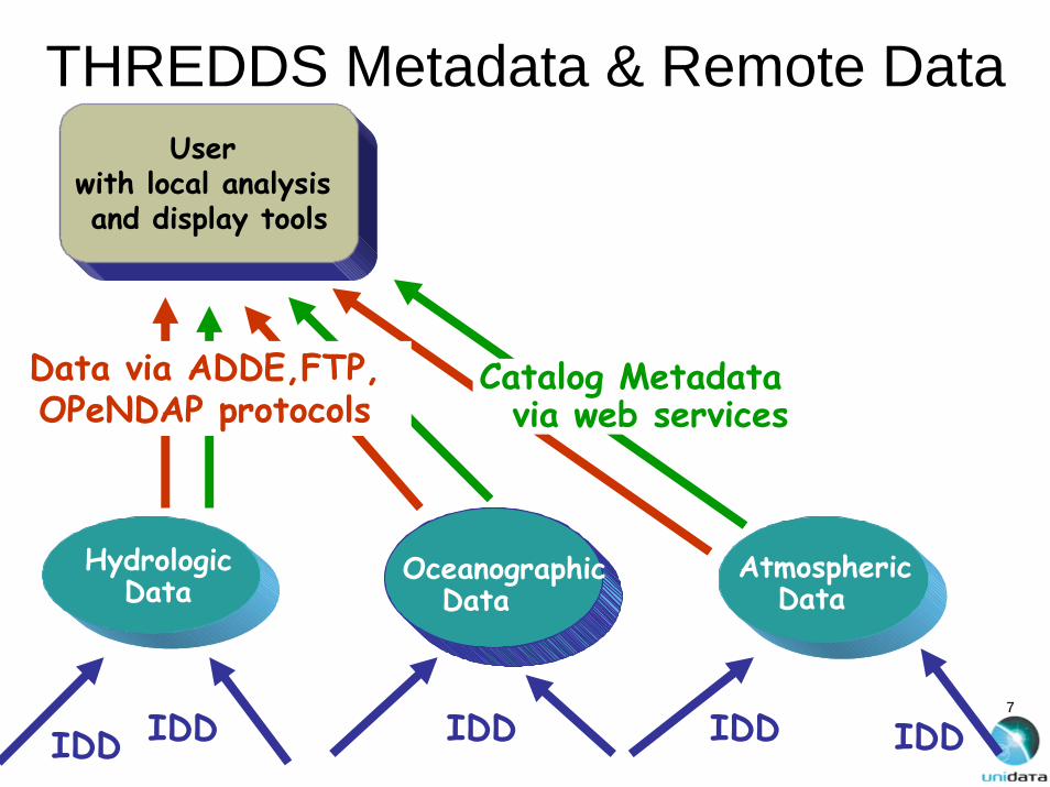
THREDDS Metadata & Remote Data
HydrologicData
OceanographicData
IDD
User with local analysis and display tools
User with local analysis and display tools
IDD IDD IDD IDD
Data via ADDE,FTP, OPeNDAP protocols Atmospheric
Data
AtmosphericData
Catalog Metadatavia web services

88
NAM CONUS 40km CONDUIT

99
THREDDS Catalogs asCollections of Metadata
• Catalogs are more than remote dataset lists:– containers for both discovery and use metadata– range from simple inventory lists with minimal data
descriptions– to web documents with embedded interactive data
analysis tools– mechanism for including datasets into digital
libraries and other discovery centers (e.g. GCMD, NSDL, DLESE, NCAR CDP)
• First THREDDS NSDL “collections” grant in 2001

1010
Original THREDDS ConceptDiscovery Centers:
e.g., NSDL, DLESE, GCMD
HydrologicData
OceanographicData
Discovery
IDD
User with local analysis and display tools
User with local analysis and display tools
IDD IDD IDD IDD
Catalog Metadatavia web services
Data via ADDE,FTP, OPeNDAP protocols Atmospheric
Data
AtmosphericData

1111
THREDDS Metadata
• What property of the Earth, ocean, atmosphere do the numbers in the dataset represent (e.g. temperature, wind speed)?
• What are the units of measure?• Where do the measurements or
predictions apply?• When were they taken or what time do
they forecast?

1212
GCMD “thredds” item

1313
Interoperability with Other Disciplines:Different Ways of Thinking about Data
• To the GIS (solid earth, hydrology, and societal impacts) community, the world is:– A collection of static featuresfeatures (e.g., roads, lakes, plots of land)
with geographic footprints on the Earth (surface).– The featuresfeatures are discrete objectsdiscrete objects with attributes which can be
stored and manipulated conveniently in a database.database.
• To the fluids (atmosphere and oceans) communities, the world is:– A set of parametersparameters (e.g., pressure, temperature, wind speed)
which vary as continuous functionscontinuous functions in 3-dimensional space and time.
– The behavior of the parametersparameters in space and time is governed by a set of equations.equations.
– Data are simply discrete points in the mathematical function space.

1414
THREDDS/GIS InteroperabilityGIS ClientApplications
THREDDS ClientApplications
Standard Protocols:WMS, WFS, WCS,CSW, SWE, GML
OGC or proprietary GIS
protocols
OGC or OPeNDAPADDE. FTP…
protocols
GIS ServerGIS ServerGIS Servers
Demographic, infrastructure, societal
impacts, …datasets
THREDDS ServerTHREDDS ServerTHREDDS Servers
Satellite, radar, forecast model output, …
datasets
Discovery Centers
Metadatacrosswalk
Open Archives Initiative (OAI) Metadata Harvesting
Metadatacrosswalk

1515
ESRI arcGIS THREDDS Integration: Schools in LEAD Forecast Rainstorm Area

1616
TDS: THREDDS Data Server• Integrated package of services• Data access
– OPeNDAP– Web Coverage Service (WCS)– netCDF subset service
• Rudimentary processing– Format transformations– Subsetting variables, space, time
• THREDDS catalogs• Open Archives (OAI) harvesting

1717
HTTP Tomcat Server
THREDDS Data Server Architecture
Datasets
Catalog.xml
THREDDS Server Application
NetCDF-Javalibrary
•OPeNDAP•HTTPServer•WCS
OAIMetadata HarvesterDL Records

1818
Common Data Model
• Combine best characteristics of netCDF, OPeNDAP, and HDF data models
• Maintain simple, elegant data access interface of netCDF
• Add useful capabilities from OPeNDAP and HDF such as:– Character strings– Structures
• Provides common model for data exchange

1919
THREDDS as a Team Effort
• UPC– coordinates collaborative activities– develops and supports catalog generation and
service technologies• Community implements servers
(e.g., several dozen ADDE servers made available as part of Unidata McIDAS distribution)
• Partners – as data providers, tool builders, interoperability
experts from academia, government, industry– represent several disciplines

2020
THREDDS Data Provider Partners• University of Alabama Huntsville• ARM Atmospheric Radiation Measurement)• CDC, the Climate Diagnostic Center • COLA, Center for Oceans Land Atmosphere • University of Florence• GMU, George Mason University • IRI/LDEO, International Research Institute/Lamont Doherty Earth Observatory • ESG, the Earth System GRID (NCAR/SCD)• IRIS DMC, Incorporated Research Institutes for Seismology Data Management Center • NCAR, the National Center for Atmospheric Research • NCDC, the National Climatic Data Center • NGDC, National Geophysical Data Center • NOMADS,NOAA Operational Model Archive and Distribution System, • University of Oklahoma• PMEL, the Pacific Marine Environment Laboratory • FNMOC, Fleet Numerical Meteorological and Oceanographic Center • SSEC, the Space Science and Engineering Center., U. of Wisconsin-Madison • Unidata Community ADDE servers• CIESIN Consortium for International Earth Science Information Network )• CUAHSI Consortium of Universities for Advancement of Hydrologic Science• ESIG NCAR Environmental Societal Impacts Group• Earthscope UCAR UNAVCO • GEON GEOphysical Network UCSD San Diego Supercomputer Center • ESRI GIS Community

2121
THREDDS partners: Analysis/Display Tool Builders
• Data Discovery Toolkit and Foundry (New Media Studio). • GDS, GrADS/DODS Server (COLA)• IDV, Integrated Data Viewer (Unidata Program Center) • INGRID (IRI/LDEO, International Research Institute/Lamont Doherty Earth
Observatory,)• LAS, Live Access Server (PMEL, the Pacific Marine Environment
Laboratory) • VGEE, Virtual Geophysical Exploration Environment (NCAR, DLESE, U. of
Illinois, Unidata, many collaborators)• WXWISE Applets (SSEC, the Space Science and Engineering Center., U.
of Wisconsin-Madison, Tom Whittaker)
• ArcGIS (ESRI GIS Clients (ESRI, Inc.) • OGC Clients (Open GIS Consortium) • MyWorld (Northwestern educational GIS Client)

2222
THREDDS Interoperability Partners• ADDE, Abstract Data Distribution Environment (University of Wisconsin – Madison,)• DIMES, DIstributed MEtadata System (George Mason University) • DODS/OPeNDAP/Aggregation Server, Distributed Oceanographic Data System/Open
source Project for a Network Data Access Protocol (University of Rhode Island, Unidata) • DLESE,( Digital Library for Earth System Education )• ESML, Earth System Markup Language (University of Alabama-Huntsville) • GCMD, (Global Change Master Directory)• OGC and ISO Standards (University of Florence)
• ADL (Gazetteer Services The University of California, Santa Barbara)• DLESE Evaluation Services (The University of Colorado CIRES) • DLESE Data Services (TERC)• DLESE Program Center Digital Library for Earth System Education • ESRI • OPeNDAP (The University of Rhode Island Open source Project for a Network Data
Access Protocol -- formerly DODS) • LAITS (Laboratory for Advanced Information Technology and Standards, George Mason
University) • NSDL Evaluation Services (University of Colorado) • OGC (Open GIS Consortium,) • SWEET (Semantic Web for Earth and Environmental Terminology)

2323
THREDDS in Action• Portal interfaces
– Unidata Motherlode– NCDC– PMEL Live Access Server
• Programmatic web services interfaces– IDV– arcGIS– IDL– Gi-GO
• Discovery– NCAR CDP– UAH NOESIS– George Mason

2424
Projects Related to THREDDShttp://www.unidata.ucar.edu/projects/THREDDS/GALEON/Reports/RelatedTechnologies.html
• GALEON/WCS• NASA/GMU ACCESS Geosciences Catalogs
CSW (Catalog Services for the Web)• GI-Go (Catalog browser and data access cliient)• netCDF (Java netCDF is basis for THREDDS Data Service)• HDF (HDF5 access via TDS)• ADDE (Client/server protocol, part of McIDAS)• CF (and COARDS) Conventions for netCDF• Live Access Server (LAS) (Incorporates THREDDS catalog system,
deployed at hundreds of sites)• Community Data Portal at NCAR• MMI (Marine Metadata Interoperability project)• SWEET (Semantic Web for Earth and Environmental Terminology)• ESIP Federation Service Collaboration Demos (includes TDS/WCS
services)• ESRI ArcGIS 9.2 netCDF Interface (works with TDS datasets)

2525
Summary• “Seamless” access to historical data at remote
sites: Client/server with ADDE and OPeNDAP • Discovery and use of remote data: THREDDS
catalogs• Interoperability with GIS data systems:
Web Coverage (and other) standard services• UPC develops core technologies, coordinates
team projects, supports integrated packages• Community deploys• Partners as data provider, discovery centers,
client implementers

2626
Recent (last week) Developments• Gi-GO catalog metadata and data access
client from U of Florence partners• Standards-based catalog generator and
client from George Mason University/NASA ACCESS project partners
• Invitation to participate in ESIP Federation proposal to NSF NSDL data-centriPathway. (Google likely partner.)

2727
Resulting Policy IssueRoles of UPC, Unidata community, and
partnerships in data search systems
Until now, the UPC has worked with partners for data discovery. Should we become more active?

2828
Future Possibilities
• UPC continues developing infrastructure and capitalizing on partnerships with search experts
• UPC takes more active role in providing search services
• UPC and Unidata community focus more resources on creating metadata content for metadata catalogs

2929
One Approach• New slot or redirection of staff to establish a “data
czar” position with responsibilities to:• Know what datasets are important, and document
their characteristics: size, format, data types, availability, etc.
• Work with community to add metadata to THREDDS catalogs.
• Create a datapedia, and get others in the community to contribute to it.
• Be a resource for developers needing to access the data.
When this is actually rolling in a couple years then search systems will be more effective
http://cdp.ucar.edu/

3030
Direct Access to Examples• http://motherlode.ucar.edu:8080/thredds/topcatalog.html• http://nomads.ncdc.noaa.gov:8085/thredds/• http://motherlode.ucar.edu:8080/thredds/catalog.html• http://www.unidata.ucar.edu/projects/THREDDS/DataPublicatio
ns/• http://www.unidata.ucar.edu/projects/THREDDS/DataPublicatio
ns/EarlyLEAD/EarlyLEAD.xml• http://lead4.unidata.ucar.edu:8080/thredds/catalog/model/UCA
R/UNIDATA/WRFNMM/catalog.xml• http://localhost:8080/thredds/catalog.html• http://noesis.itsc.uah.edu/• http://gcmd.nasa.gov• http://cdp.ucar.edu/• http://zeus.pin.unifi.it/projects/gi-go/gi-go.jnlp

3131
Motherlode Portal Catalog of Catalogs

3232
NCDC Server

3333
NCEP NAM Individual Run

3434
NetCDF Subset Server

3535
Catalog of catalogs in XML(programmatic interface)

3636
Catalog of catalogs in IDV(Catalog from within a Client)

3737
TDS-related Search Systems
• George Mason/NASA Catalog Services for the Web collaborative project
• NCAR Community Data Portal• Global Change Master Directory• UAH NOESIS Earth system search
system

3838
NCAR CDP Data Search

3939
GCMD Search for “thredds”

4040
UAH NOESIS Earth System Search


