Portland State University PDXScholar History Faculty Publications and Presentations History 1-1-2007 e meaning of falling water: Celilo Falls and the Dalles in historical literature William L. Lang Portland State University Let us know how access to this document benefits you. Follow this and additional works at: hp://pdxscholar.library.pdx.edu/hist_fac Part of the United States History Commons is Article is brought to you for free and open access. It has been accepted for inclusion in History Faculty Publications and Presentations by an authorized administrator of PDXScholar. For more information, please contact [email protected]. Citation Details Lang, W. L. (2007). e meaning of falling water: Celilo Falls and the Dalles in historical literature. Oregon Historical Quarterly, 108(4), 566-585.
Transcript
Portland State UniversityPDXScholar
History Faculty Publications and Presentations History
1-1-2007
The meaning of falling water: Celilo Falls and the Dalles inhistorical literatureWilliam L. LangPortland State University
Let us know how access to this document benefits you.Follow this and additional works at: http://pdxscholar.library.pdx.edu/hist_fac
Part of the United States History Commons
This Article is brought to you for free and open access. It has been accepted for inclusion in History Faculty Publications and Presentations by anauthorized administrator of PDXScholar. For more information, please contact [email protected].
Citation DetailsLang, W. L. (2007). The meaning of falling water: Celilo Falls and the Dalles in historical literature. Oregon Historical Quarterly,108(4), 566-585.
Celilo Falls and The Dalles in Historical Literature
NO PLACE STANDS STILL IN MEANING. Human experiences, per ceptions, and purposes attached to geographical locations change over time
and alter the ways places relate to the lives of individuals and communities.
Our connection to place is constantly changing as its physical composition
changes, its cultural references alter, and individual connections revise.
Understanding place, as one prominent historical geographer has argued, is not a problem but a riddle. Place is a riddle because it accommodates
human experience and expression, while it exists as a physical location. We
can best wrestle with the riddle by paying attention to our conversation
about place, especially why we identify it as we do and how we have thought about it over time. Physical structure and location dominate our references
? a mountain locale, desert expanse, or specific urban district ? and so
it is with Celilo Falls and The Dalles on the Columbia River. Much of the
conversation has been about a place of falling water, about a locale where a
great river is constricted and tumult rules. Not surprisingly, what meaning is attached to that dramatic place depends on who sees the falling water,
when they view it, and what difference it makes to their lives. There is no
singular viewpoint on places of meaning.1 In 1825, those distant from the West coast of North America knew
about the Columbia River, but not a great deal. Mariners had spread the
word about the river's rough sea entrance, and the few published explor ers' reports included an outline of the river's course and the remarkable
basalt gorge that cut through the Cascade Mountains about 120 miles
upriver from the mouth. One extended place along that stretch of river in
OHQ vol. 108, no. 4 ? 2007 Oregon Historical Society
This content downloaded by the authorized user from 192.168.52.75 on Fri, 7 Dec 2012 14:29:02 PMAll use subject to JSTOR Terms and Conditions
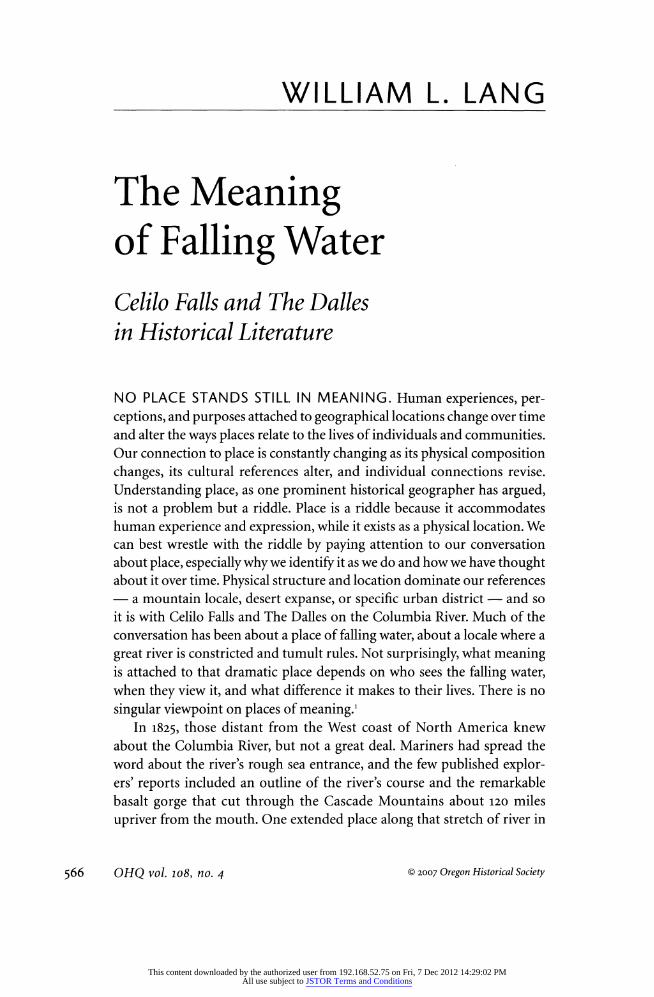
especially simple when compared to descriptions that could be offered by residents. The first published descriptions of Celilo Falls-The Dalles docu
ment Tuan's point. They focus on the unusual and the instrumental, on
what a powerful place it seemed to be and how it might bring great benefit
to anyone who could possess it. In 1807, Patrick Gass, a sergeant in the Lewis
& Clark Expedition, published the first account of the expedition's travel on
the Columbia River, including the first written description of Celilo Falls
and The Dalles. Gass's journal, which his publisher in Pittsburgh polished for better reading, met an avid audience, selling out quickly and justifying
succeeding editions in 1808,1810,1811, and 1812. A French edition appeared in 1810, and at least one westering fur trapper, Andrew Henry, took a copy of Gass's journal with him into the Rockies that year. The Gass description of Celilo Falls invoked experiential understanding: "About the great pitch [Celilo Falls] the appearance of the place is terrifying, with vast rocks, and
the river below the pitch, foaming through different channels." It was a
place perfect for fishing, Gass tells his readers, because salmon can easily ascend in the spring until they are forced
to concentrate at the falls. The falls were
"terrifying," but it was also a place that
produced wealth.2
By 1814, when Nicholas Biddle edited
and published a two-volume edition of the
Lewis and Clark Expedition journals, maps
outlining the course of the Columbia River,
including the gorge and the falls, had also
been published, including the large map that William Clark had completed in 1810.
The Biddle edition included the captains' extensive commentary on the activities of
the Indian people they encountered on the
river in the fall of 1805 and in the spring of
1806. The Biddle rendering of the explorers'
experience at the falls in 1805 emphasized the travails of passage and the challenge of negotiating a river that "was divided
into several narrow channels, by rocks and
islands," requiring that they examine its
structure and plan a safe descent. The cap tains commented on "the pilfering of the
natives, which we apprehend much more
than we do their hostilities," but they did
TRAVELS TO THF.
SOURCE OF THE MISSOURI RIVER .4VI) ACROSS THF
AMERICAN CO ? 77 N E A 7
PACIFIC OCEAN.
BY ORDER OF THE GOVERNMENT OF THE UNITED STATES.
1804, 1805, and 1806.
BY CAPTAINS LEWIS AND CLARKE.
pubttoht? from the ?ffitt.il Hqwit,
ILLUSTRATED BY A MAI' OF THE ROUTE, AND OTHER MAPS.
ton?oit : PRINTED FOR LONGMAN, HURMT, KEES, ORNE, AND BROWN, MreitvcwTifji.no>?-.
_1MI._
Both Nicholas Biddies History of the Expedition under the Command of Lewis and Clark and this nearly verbatim
version, Travels to the Source
of the Missouri River, were
published in 1814.
568 OHQ vol. 108, no. 4
This content downloaded by the authorized user from 192.168.52.75 on Fri, 7 Dec 2012 14:29:02 PMAll use subject to JSTOR Terms and Conditions
not hesitate "to follow the route adopted by the Indians themselves" and
admitted that the work of portaging around the worst of the obstructions
"would have been very inconvenient, if the Indians had not assisted us in
carrying some of the heavy articles on their horses."3 Lewis and Clark also
looked at the "Great Falls of the Columbia" instrumentally, as part of a
potential commercial pathway across the continent. Indian fishing interested
them, but more important to them was the implication of ownership and
control. Readers of Biddle's version of the first American land exploration of the Columbia could not have missed the characterization of the falls as
a problematic place, a potential obstacle to economic use.
Exploration did not lead to settlement in the region, but it did help stimulate capitalist investment, the leading edge of Euro-American incursion
into the Columbia Basin. John Jacob Astor's Pacific Fur Company arrived
in 1811, as did David Thompson of the Northwest Company, but it was the
British-chartered Hudson's Bay Company (HBC) in the 1820s that brought a powerful transnational trading network to the Columbia. HBC traders
and other travelers quickly recognized the falls on the mid-Columbia as
a critical landscape in their operations, but it would be years before their
accounts found their way to publication. Nonetheless, by the 1840s, when
American emigrants began streaming overland to the Oregon Country, several published travelers' accounts and memoirs had added new descrip tions of Celilo and The Dalles, usually commenting more on how effectively Indian groups possessed the place than on the danger inherent in descending the river. Lewis and Clark had complained about what they believed was
Indian obstinacy at the falls, but their comments documented only solitary incidents in a fast-paced transit that read more as an adventure story than an economic survey. Travelers and fur traders saw the falls in much different
context, one that valued economic efficiency in travel and commerce. For
them, Indian guardians of the place stood as gatekeepers, impediments to
economic intercourse.
Washington Irving's creative and widely read description of Astor's
enterprise, Astoria, introduced readers to a "slippery people" at Celilo and
The Dalles, who were "shrewder and more intelligent" than the Indians the
1811 overland travelers had encountered in their difficult journey from the
Missouri to Astoria. In the Irving recounting, the Wishrams at Celilo used
ruses and clever dealings to extract surreptitious tolls from travelers. The
Dalles and Celilo emerged less as a geographical place than a place of intrigue and social conflict, a choke-point that could be passed only by intelligent
diplomacy. John K. Townsend, a naturalist who traveled with a later fur
trading enterprise, published an account of his experiences in 1839, three
years after Irving's Astoria. Townsend saw the falls primarily as a threatening
Lang, The Meaning of Falling Water
This content downloaded by the authorized user from 192.168.52.75 on Fri, 7 Dec 2012 14:29:02 PMAll use subject to JSTOR Terms and Conditions
environment, which he portrayed as a tempestuous place where the river
narrowed to fifteen-foot wide passages, the water roiling and foaming "like
an enormous cauldron." His portrayal of the Indian guides who facilitated
passage was disdainful and prejudiced, as if their presence on the river was
illegitimate. A decade later, in Adventures of the First Settlers on the Oregon or Columbia River, Alexander Ross recounted his trip up the river in 1811 as
a Pacific Fur Company employee. Describing the falls landscape as a "bare,
rugged, and rocky" place that was "swarming with Indians, all as anxious to
get to us as we were to avoid them," Ross characterized The Dalles as "the
great emporium or mart of the Columbia." Almost grudgingly, he acknowl
edged Indian control of the landscape. No visitor, Ross implied, could miss
the central importance of the place to Indian residents and the thousands
of indigenous people who came there "for trade and traffic" and for social
izing at a "great rendezvous during the summer."4
Popular travelers' accounts of their experiences on the Columbia River
always mentioned Celilo Falls and The Dalles. Among the first published was
Samuel Parker's Journal of an exploring tour beyond the Rocky Mountains.
The first of a string of Protestant missionaries who headed west to minister
to Indians, Parker traveled with fur traders to the Rockies and then trekked
overland to the Columbia in 1835. His account, which gained popularity
through the religious press, portrayed the region and its people in appealing
ways, often quite at odds with the fur traders' perceptions. He characterized
Indians above Celilo "as living in harmony, without any feuds or jealousies. It speaks much in favour of their kind and peaceable dispositions." When he
encountered Indians who fished at Celilo, Parker thought them untidy and
careless about their appearance, but he took note of their industry and the
centrality of salmon fishing to their lives. What struck him most, though, was the geography of the falls, the sheer drama of the place. Downstream
at the Long Narrows, Parker highlighted what he believed would be the
ultimate utility of the place ?
power. In the first reference to The Dalles as
a generator of power, Parker wrote, "the falls and La Dalles furnish a situa
tion for water-power equal to any in any part of the world." His notation in
1838 might appear surprising, considering that the fur trade still dominated
Euro-American economic activity in the Columbia River Basin, but there
were few places in North America in the early nineteenth century where riv
ers fell more than a few feet that someone did not see spinning waterwheels
and prosperous factories. Nonetheless, Parker's take on the potential for
the Columbia's most spectacular location of falling water remained largely
ignored for over a half-century.5
By 1865, when Samuel Bowles published his best-selling travel account,
Across the Continent, the river landscape in the Columbia River Gorge had
570 OHQ vol. 108, no. 4
This content downloaded by the authorized user from 192.168.52.75 on Fri, 7 Dec 2012 14:29:02 PMAll use subject to JSTOR Terms and Conditions
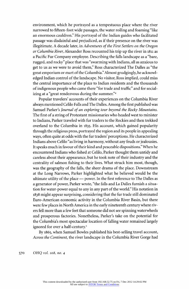
By 1867, when Carleton Watkins photographed this scene at the Celilo portage, the place had become an important staging area for the brisk upriver trade by steamboat.
provided new access for passengers, who made their way upriver in relative
comfort as they appreciated the landscape from new perspectives. In July 1867, a young Carleton Watkins rode upriver on an OSN boat to photograph the storied, dramatic scenery. His widely disseminated stereographs of OSN
shipping operations, portage railroads, and the river at the Long Narrows
and Celilo may have publicized the area more than any textual description. The public image of the Columbia and the rapids took on a new form, by artifice, and attracted a new appreciation.7 Watkins' photos, and the work of
many other photographers, led to an aesthetic appreciation of the Columbia
and its dramatic landscapes. By the 1880s and 1890s, steamboat companies and the transcontinental railroad on the Oregon shore brought visitors to
see the powerful river, the basalt cliffs, and the falling water. Railroad pub licists promoted the middle-Columbia landscape as glorious, a place where
"the scenery is arranged most effectively, becoming grander and wilder till
the climax is reached at the marvelous rapids above Dalles City."8 It was a
romantic viewpoint tailored for the visitor and pointedly bereft of earlier
descriptions of the place. At the turn of the century, the complete rendi
tion of Celilo Falls and The Dalles included romantic descriptions as well
as references to ancient Indian fishing grounds, Lewis and Clark's difficult
572 OHQ vol. 108, no. 4
This content downloaded by the authorized user from 192.168.52.75 on Fri, 7 Dec 2012 14:29:02 PMAll use subject to JSTOR Terms and Conditions
passage, and fur-trade-era conflicts over passage. In texts that portrayed an
authoritative viewpoint on the history of the river ? such as those writ
ten by Frances Fuller Victor, Joseph Gaston, William D. Lyman, and other
popular writers ? those disparate images of the middle Columbia found
their way into a generalized picture of the place.9 In the early twentieth century, little foretold the future of Celilo Falls
and The Dalles, but there were signs of a newer valuation of the place. "To
provide for the rapidly incoming population," as Lyman wrote in 1909 in
The Columbia River, the first comprehensive history of the river, "it was
necessary that human labour and ingenuity modify the untamed forces of
the river."10 That ingenuity had been applied at the Cascades, where by 1896
government engineers had created a by-pass canal that rendered the rapids irrelevant to river transportation. In 1905, engineers began working on a
new, more difficult canalization at The Dalles and Celilo Falls. Finished in
1915, the canal became both a harbinger of more artificial constructions on
the river and a testament to the logic of economic development. Enterprise
increasingly vied with romance as a definer of the place. At the canal's
dedication, J.N. Teal, an indefatigable promoter of river transportation
improvements, told the gathered celebrants: "The river is free at last, and
tolls based on the control of this portage will no longer be levied either by red man or white man. One chain was sundered at the Cascades; another we
are breaking today; soon Priest Rapids will be freed, and then our dream will
almost be realized." Readers who paid attention to Teal's Address, which was
widely distributed and reprinted, understood that a new era had dawned, not because the canal would necessarily create the wealth Teal promised, but because it reified the vision of a completely reorganized river.11 "Above
Celilo there are many rapids," Teal wrote,
which ultimately will be improved by means of locks and dams, and the general canali
zation of the river. With every dam, water power will be created, and this power should
be utilized.... All beneficial uses of these streams should be taken advantage of, and
when they can be made available in connection with the improvement for navigation,
it is worse than a blunder not to do so.12
Waterpower, the focus of Samuel Parker's nearly forgotten comment
many decades before, quickly became a preferred reason for development at The Dalles. The first official study of The Dalles as a hydroelectric loca
tion was published in 1900, when federal engineers first surveyed the site
at Long Narrows for a power dam that would also improve navigation.13 Construction of The Dalles-Celilo Canal in 1915 answered the navigation
question, while the power study rested on the shelf until 1905, when the
state of Oregon took up the idea. Interest in damming big rivers to make
Lang, The Meaning of Falling Water 573
This content downloaded by the authorized user from 192.168.52.75 on Fri, 7 Dec 2012 14:29:02 PMAll use subject to JSTOR Terms and Conditions
electricity brought engineers to the Upper Missouri River in 1908, along the
western slope of the Sierra Nevada in California by 1905, and to the Upper Colorado River in 1910. In the Pacific Northwest, engineers had succeeded
in building a hydropower plant at Willamette Falls in 1889 and in sending its
power to Portland, fourteen miles away, accomplishing the first long-distance transmission of direct current in the United States and the first transmission
of alternating current the following year.14 Celilo Falls and The Dalles, rather
than the object of concern as an obstacle to navigation, suddenly became a location for an economic bonanza, where engineers sought to exaggerate the river's fall and create a bountiful source of power.
In his report on building a dam at The Dalles, published in 1912, Oregon State Engineer John H. Lewis outlined what he believed to be "one of the larg est and perhaps the cheapest water power project in the world." He proposed
building a 180-foot high, 300-foot-long concrete river-blocking dam at Big
Eddy, three miles upriver from The Dalles. The proposal included blasting an artificial channel some 300 feet wide and 20 feet deep through the basalt
on the Washington side of the river, extending 1 Vi miles to a powerhouse, which would produce 300,000 horsepower from twenty-one turbines. Who
might use so much power begged a question the engineer could not avoid.
By 1912, Portland General Electric Company, the owner of six hydroelectric
power stations and nine steam plants, dominated the electricity market in
the Willamette Valley.15 How could the market absorb the additional power,
approximately 10 percent of the power PGE supplied customers in 1910? The
state engineer admitted at the outset that "the project looked ridiculous for
want of a market," but his report promised that new "iron and steel reduction
works, wood distillation, and the production of nitrogen fertilizer" would
sprout by the dam once the power flowed. If that image of an industrialized
landscape at The Dalles did not sufficiently answer the question, he expan
sively suggested, then the power plant could practically transform the region
by electrifying the Columbia Basin, where the dreams of industrialists and
agriculturalists could be realized. "Both Oregon and Washington are equally interested in this project," his report noted.
The United States is also interested because of its control over navigation, and because
of the further fact that it is the owner of considerable vacant land along the Columbia
River in both states which can be reclaimed only by pumping from the river. It is during the summer flood period that the greatest amount of power will be available. This is the season when such cheap power can be utilized for pumping purposes.16
The engineer's report was a harbinger of a dynamic, twentieth-century
perspective on the falls and rapids. All dams swamp history, but the project
planned for The Dalles portended a culturally significant alteration of a vis
OHQ vol. 108, no. 4
This content downloaded by the authorized user from 192.168.52.75 on Fri, 7 Dec 2012 14:29:02 PMAll use subject to JSTOR Terms and Conditions
ible landscape that had prevailed for thousands of years. Nineteenth-century travelers and early settlers had seen the place from many angles, but it had
always retained its power and integrity, despite its problematic meaning for non-residents. Seeing the falls as a transformative place, where human
artifice could alter geography and effect changes in distant locales, made
Celilo and The Dalles a revolutionary place. The idea of a big dam proposed a radical rendering of place, while it masked or denied the falls' historic role
as a conservative place, where continuity had reigned and community had
aligned life with the falling water. A dam offered a revolutionary future.
Spinning turbines would electrify distant machines and power siphons that
would make the Columbia's water a commodity in a new era of expanded
agriculture. The idea of the dam cast a broad shadow as reified opportunity, a grand opportunity, as J.N. Teal put it, "worse than a blunder" not to use.
The principal users of the Columbia when the idea of a big dam was
first suggested were the fishers. For them, Celilo and the other fishing sta
tions on the middle Columbia had become a treasure house. As early as the
1880s, commercial fishing interests had invaded the area to harvest tons of
fish each year, claiming the landscape Indians had used for millennia. The
companies that established operations in the middle Columbia brought new technologies with them, especially the monstrously efficient fishwheels.
At the height of fishwheel use ? from the 1880s to the mid-i930s ? more
than thirty fixed fishwheels and fishwheel-scows operated at various times
and places between Threemile Rapids and Celilo Falls. Fishwheels averaged
fifty tons of fish each year, each one taking more than double what has been
estimated as the annual catch of nonindustrial Indian fishers in the middle
Columbia.17 Francis Seufert, owner of the largest cannery operation on the
middle Columbia, bought fish from Indian fishers, but his business depended on the mechanical fishwheel harvests. After Oregon and Washington voters
made fishwheels illegal (1926 and 1935), Seufert facilitated Indian fishing to
make up for his lost catch, but that did not alter the plain reality of the new
Celilo ? the fishing places had changed hands from Native fishers to indus
trialists. The middle Columbia was an industrial fishing place, complete with
machines; Chinese, Filipino, and other ethnic laborers; and a tinned product that went to the world with colorful labels proclaiming its origin.18
The investment by fishers at The Dalles and Celilo did not dampen the enthusiasm others had for altering the Columbia to suit their desires. Aspir
ing agricultural communities upriver from Celilo, for example, wanted a dam
built at Umatilla Rapids to facilitate navigation and to impound a massive
volume of river water for mid-Columbia irrigation projects. Earlier projects under auspices of the 1902 Reclamation Act had proved disappointing, but
boomers believed that more water ? much more water ? would solve their
Lang, The Meaning of Falling Water
This content downloaded by the authorized user from 192.168.52.75 on Fri, 7 Dec 2012 14:29:02 PMAll use subject to JSTOR Terms and Conditions
This photograph shows Seuferfs cannery, perched on the edge of Fifteenmile Creek, with the location of Seuferfs No. i and N0.2 fishwheel sites and Threemile Rapids in the distance.
problems. Navigation interests, including shipping companies and port
developers in Portland, talked up dams on the Columbia as a technological
cornucopia that would make all communities wealthy. By 1922, a Bureau of
Reclamation report concluded that a big dam at Umatilla Rapids was uneco
nomical, regardless of projected reclamation water use, but dam-promoters maintained a steady drumbeat of advocacy
? they would finally succeed
after World War II, when Congress authorized McNary Dam on the site.19
The dam site at The Dalles had not been the focus of irrigationists, but
that changed when the power planners returned to the river. The so-called
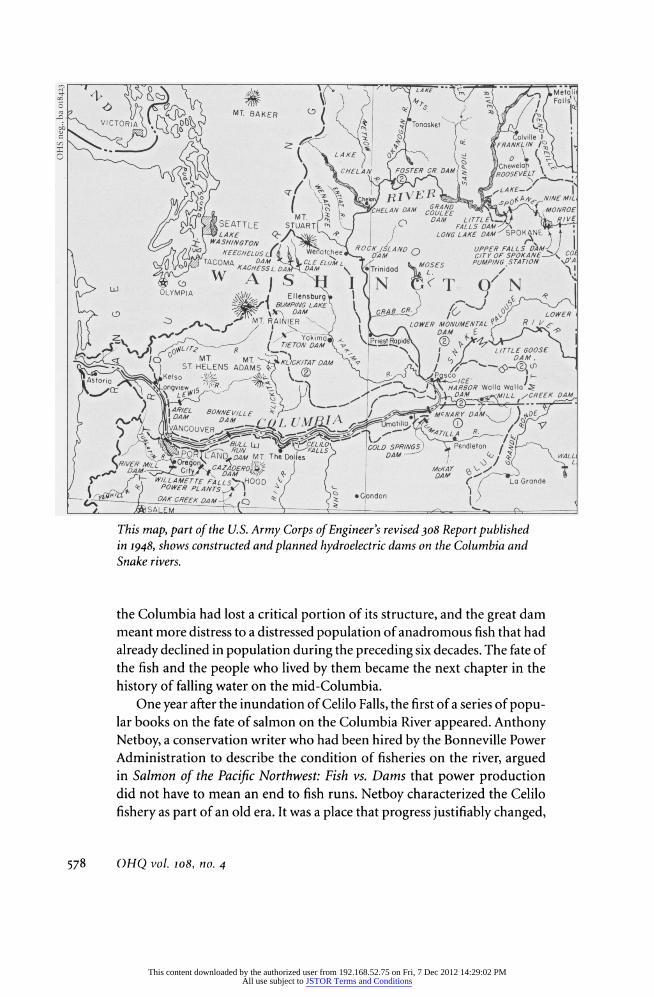
308 Report on the Columbia, published in 1932, plotted ten main stem dams
on the river, each at a promising power-generating and navigation-enhancing location. At The Dalles, federal engineers originally sketched out a massive
high dam that would have backed up a reservoir for more than 100 miles up the mid-Columbia. The published report included a scaled-down version,
with an additional dam at the John Day River and a smaller reservoir, but
the consequence was the same ? an end to Celilo Falls and fishing areas at
Long Narrows and a new industrialization of the place, replacing the just outlawed fishwheels with electrical dynamos and introducing another way to capture wealth from falling water. The place would be transformed.20
It is not an exaggeration to say that the 308 Report outlined the Colum
bia's future, but it may be more accurate to state that it established a frame
OHQ vol. 108, no. 4
This content downloaded by the authorized user from 192.168.52.75 on Fri, 7 Dec 2012 14:29:02 PMAll use subject to JSTOR Terms and Conditions
work for river developers and a target for those who wished to slow or halt
the damming of the river. Celilo Falls became vulnerable to federal water
resource planners, while individuals, fishing groups, and conservationists
throughout the Pacific Northwest worried that the most ancient fishing
ground in the region might disappear. Concerns about the fate offish runs
intensified after the U.S. Army Corps of Engineers completed Bonneville
Dam in 1938 at river-mile 146, some seventy miles downriver from Celilo, because even optimistic estimates of fish passage made it clear that dams
damaged fish runs. After World War II, planners went back to the 308 Report to make the Columbia River the world's greatest hydroelectric generating
system, but Indian fishers and commercial fishing interests challenged the
scheme, demanding that their interests, Celilo's ancient fishery, and the
salmon be allowed to survive. Meetings held in the region from 1944 to 1948
gave the fishers no relief from the planned dam, even though the Corps' legal
department warned that if the courts awarded Indians a property right in
fish, the dams could be construed as violating their treaty fishing rights. The
government planners willfully ignored the warning, although they included
significant proposals to mitigate salmon losses caused by the dam. By 1948, the Corps of Engineers and the Bureau of Reclamation had completed
major new studies of Columbia River water resources, and each identified
The Dalles Dam as central to regional development, because it would add
701,000 kilowatts of prime power to the Pacific Northwest power grid and
available power to run irrigation pumps in places as distant as Prineville
and Bend, Oregon.21 In 1950, Congress authorized The Dalles Dam, and seven years later it
stood ready to flood out ten millennia of human relationships at the most
ancient place on the great river. An instrumental viewpoint had triumphed. The economic importance of fishing there and the cultural integrity of the
place proved insufficient rationales for preservation. The falls had to become a new place.22 The gates closed in March 1957 and a stillness dropped on the
falls, like an exhale of life. It was less than fifty years from the first detailed
dam proposal to the day Celilo Falls disappeared. Inundating the falls caused enormous distress and pain for Indian people. That loss received some notice
in newspapers, but a triumphalist perspective dominated media accounts
of the dam.23 When noted regional author Stewart Holbrook published The
Columbia in the "Rivers of America" series in 1956, he lamented the new
river, declaring that he loved "the Columbia as it was more than as it is, or
as it is likely to be next year," yet he did not hesitate to declare the river a
new recreation place that would replace "the many homely and frail little
civilizations that flourished at one time or another along its banks and on
its waters."24 It might have appeared to be an improved river to some, but
Lang, The Meaning of Falling Water
This content downloaded by the authorized user from 192.168.52.75 on Fri, 7 Dec 2012 14:29:02 PMAll use subject to JSTOR Terms and Conditions
This map, part of the U.S. Army Corps of Engineer's revised 308 Report published in 1948, shows constructed and planned hydroelectric dams on the Columbia and Snake rivers.
the Columbia had lost a critical portion of its structure, and the great dam
meant more distress to a distressed population of anadromous fish that had
already declined in population during the preceding six decades. The fate of
the fish and the people who lived by them became the next chapter in the
history of falling water on the mid-Columbia.
One year after the inundation of Celilo Falls, the first of a series of popu lar books on the fate of salmon on the Columbia River appeared. Anthony
Netboy, a conservation writer who had been hired by the Bonneville Power
Administration to describe the condition of fisheries on the river, argued in Salmon of the Pacific Northwest: Fish vs. Dams that power production did not have to mean an end to fish runs. Netboy characterized the Celilo
fishery as part of an old era. It was a place that progress justifiably changed,
578 OHQ vol. 108, no. 4
This content downloaded by the authorized user from 192.168.52.75 on Fri, 7 Dec 2012 14:29:02 PMAll use subject to JSTOR Terms and Conditions
whose "origins are lost in the mists of unrecorded history." Indian fishers
had to face a new era, Netboy explained, because "life is changing rapidly and the loss of the ancient grounds is but another step in the transition
to a new and bewildering existence." This view of place pushed the social
consequences of such great change to the margin, while underscoring the
river's new technological status. The Dalles Dam, like others in the Columbia
River system, would be a place of experimentation, where devices, studies, and clever mitigations would defuse the conflicts between fish and dams. "As
we look ahead," Netboy wrote in 1958, "it is inconceivable that the develop ment of the Pacific Northwest's water resources will be indefinitely delayed
by fish versus dam conflicts."25
Netboy's optimistic interpretation of the radical transformation of the
Columbia River's most storied fishing location can be seen as nearly equal
parts hope and ambition, but his effective dismissal of Indian treaty rights missed the most important legacy of Celilo Falls. Indian fishers had gone to court in 1947 to halt the building of McNary Dam, and suits had been
brought by Indians defending fishing rights at Celilo and Long Narrows
locations during the 1940s; but the pendulum of change on the river did not
really swing back for Indians until 1969, when Judge Robert Belloni ruled in
Sohappy v. Smith that the state of Oregon had to honor Indians' treaty rights to fish in common with non-Indians. That ruling, combined with similar
judgments by Judge George Boldt in Washington State, established a solid
confirmation of Indian fishing rights on the Columbia in the areas that had
supported fishing at the time of the treaties in 1855. As Fay Cohen explains in Treaties on Trial, even as a drowned-out place Celilo continued to exert
influence. In federal courtrooms, state fisheries departments, and especially councils of tribal fishers, the falls remained the ultimate reference to loss of
salmon, destruction of rights, and damage to people. The drowning of Celilo
Falls had been traumatic, an event that defied adequate representation. The
resuscitation of Indian fishing rights incrementally allowed Celilo a voice, a
small but important representation in the remade world of the engineered Columbia. Cohen highlights the new significance of Celilo in recounting a
1981 three-hundred-mile walk Indians took from Celilo Falls to congressional
hearings in Seattle as an effective protest against yet another diminution of
their fishing rights. She quotes Indian poet Ed Edmo, who spoke from the
hearings as if from the submerged Celilo: "The white man thinks the river is
for sport, but it's not; the river is for life."26
The protest in 1981 defeated one of the many federal and state attempts to
limit Indian fishing on the Columbia in the wake of the federal court deci
sions. During the 1980s and 1990s, anyone familiar with the fate of Indian
fishers on the river understood that each defense of fishing rights was also a
Lang, The Meaning of Falling Water
This content downloaded by the authorized user from 192.168.52.75 on Fri, 7 Dec 2012 14:29:02 PMAll use subject to JSTOR Terms and Conditions
potential commentary on the fate of Celilo Falls. Journalists, historians, legal scholars, and advocates wrote about the effects of the decision to build The
Dalles Dam. Few understood, though, how difficult defending fishing places and fishing rights had been until Roberta Ulrich, a journalist who had cov
ered some of the disputes on the river as a correspondent for the Oregonian, wrote Empty Nets, which laid out a story of Indian resistance and persistence in seeking just compensation for their losses. Ulrich's narrative focuses on
two competing views of Celilo and other Indian fishing places on the river; one saw those places as central to life and culture, the other saw them as at
best nuisances and at worst impediments to the interests of society and even
the survival of fish. Despite anyone's evaluation of the legitimacy of these
views, a strikingly singular power resides in the attachment of history, life, and culture to Celilo Falls. Its power to symbolize its own struggle for life
and the defense of like places is profound. Ulrich quotes Yakama historian
Richard LaCourse: "The loss of the historic falls was the darkest day in the
common psychological history of the tribe in the current century. The policy of termination was incarnated in the destruction."27
The story of destruction at Celilo drew interest from historians. Most of
them told the story of development, but a few began to look at Celilo and
The Dalles as places. Charles Wilkinson's analyses of fishing rights cases
and their importance in changing the face of the American West, as in his
Crossing the Next Meridian, gives Celilo Falls an important part in the drama.
The most thorough historical account, though, is Katrine Barber's Death of Celilo Falls, an ambitious book that makes clear why the end of a place does
not mean the end of its influence. Celilo's depth in cultural importance, eco
nomic value, and spiritual significance could not be purchased, yet that was
exactly what the federal government proposed to do by offering a singular
compensation to Indian fishers for transforming Celilo from a productive
place to a painful memory. Even if that compensation had been just, which
Barber makes clear it was not, there is no calculus for such an exchange ? a living place for abstract economic benefits. The place for living, Celilo
Village near the drowned falls, became a place of ongoing tension between
federal authorities and the remaining community. The power of the falls
devolved to a small and embattled place, where poverty rarely lifted and most
outside the community wanted it to fade from view. Barber quotes village resident Arita Davis on why the place remains important: "I hope you can
understand. We don't 'come from' anywhere; this is where we were born,
this is where we lived all our lives and we don't want to leave."28
The power of place is centered in human experience. Understanding that
experience at Celilo Falls and The Dalles requires the horizontal viewpoint that geographer Yi-Fu Tuan identifies as complex and the near opposite of
OHQ vol. 108, no. 4
This content downloaded by the authorized user from 192.168.52.75 on Fri, 7 Dec 2012 14:29:02 PMAll use subject to JSTOR Terms and Conditions
an aesthetic perspective. It is one, Tuan argues, that can be expressed "only with difficulty and indirectly through behavior, local tradition, lore, and
myth."29 By the end of the twentieth century, people who knew Celilo from
experience began publishing their memories of a place connected to them
through tradition, lore, and myth. Working with anthropologist Eugene Hunn, James Selam described his family's fishing community at Sk'in just below Celilo Falls on the Washington side of the Columbia, where fishers
seined their fish from a sand spit. Selam remembered it as a place governed
by a complex set of relationships, but also a landscape of stories, where
specific locations held stories that explained how Coyote brought salmon to
the people or why salmon returned each year. He described the place from
inside, looking out at the world from the fishing place, not from outside
looking in.30 Allen Pinkham, in Salmon and His People, collected descrip tions from Nez Perce fishers who remembered Celilo as "one continuous,
deafening roar [with] a sound and smell all its own." In their memories, Celilo emerges as a place of profound connection, from father to son, uncle
to nephew and niece, and today to a millennial past. "It gave me a feeling and assured me," Levi Holt remembered of his fishing with relatives, "that
all Indian people honored the salmon in the same way."31 In memory, Celilo
remains a living force, because Indian people reject the idea that it is irrel
evant to their lives today. Memories of place require detail, context, and social connection to
communicate meaning. The idea of a memorialized place in the western
tradition often requires a separation or distance from the present, where the
details and context of living are walled off and assigned a static existence in
the past. In When the River Ran Wild!, Kiksht Chinookan fisherman George
Aguilar's dynamic description of the culture ways of mid-Columbia Indians, the memorial to Celilo is embedded in details that link fishing gear to fam
ily work to proper behavior to jokes told about conflicts over good fishing
spots. The fishing landscape at Celilo, Aguilar explains, was more than good
gaffing points or spots where fish were available nearly year round. It was
a living landscape, where humans and fish shared the environment, where
every human action rippled through nature. Ending fishing at Celilo and
drowning the place, Aguilar suggests, does not erase the memory and its
ability to instruct the living.32 Instruction, however, does not reside in the
memorialized place. It is pried loose by questions, especially those posed
by people whose lives are shaped by the consequences of profound change. In As Days Go By, a history of the Cayuse, Umatilla, and Walla Walla of the
Confederated Tribes of the Umatilla Indian Reservation, and The Silailo
Way, an investigation of Indians and law on the Columbia River written by Indian lawyers, significant events in Celilo's legal history extend the reach
Lang, The Meaning of Falling Water
This content downloaded by the authorized user from 192.168.52.75 on Fri, 7 Dec 2012 14:29:02 PMAll use subject to JSTOR Terms and Conditions
of fishing rights, the importance of tribal sovereignty, and the reshaping of
property relationships between Indian people and the Columbia River. The
meaning, as Umatilla tribal judge William Thompson writes, is that Indian
fishers at Celilo "were free and independent, and we exercised our sovereignty the same way. We could provide for ourselves. We have regained that now
with a different economy, which still includes the Way'am values."33
Celilo Falls and The Dalles emerge from the literature as complex places that cannot be understood from one vantage point. The visitor's perspective is as necessary as the resident's. Neither can carry the burden of explaining the place, what has happened there, and what social and cultural meaning should stand as description. In the massive changes brought through the
application of brute-force technologies in the twentieth century, there was
such a transformation to the landscape that trauma became a powerful addition to the previous list of human reactions to Celilo, the place, and
its history. No place is fixed and all places change with time, but inherent
to the path of change is its meaning, the web of connections that keeps us
attached to it.
582 OHQ vol. 108, no. 4
This content downloaded by the authorized user from 192.168.52.75 on Fri, 7 Dec 2012 14:29:02 PMAll use subject to JSTOR Terms and Conditions
1810-1813, Bison Books (Lincoln: University of Nebraska Press, 1986), 132,128-30. In his
preface to this edition of Ross's memoir,
historian James P. Ronda emphasizes that
this is an important eyewitness account of
life on the Columbia and that Ross used his
own journals, not his memory, for details of
his travel up the Columbia.
5. Samuel Parker, Journal of an Exploring tour Beyond the Rocky Mountains under the direction of the A.B.CF.M. performed in the
years 1835, '36, and '37 (Ithaca, N.Y., by the
author, 1838), 130. Government-sponsored
surveys of the West that included descrip tions of the Columbia River Gorge appeared
during the 1840s and 1850s, written by sci
entists, government explorers, and military
surveyors. Prominent examples are: Solomon
Nunes Carvalho, Incidents of travel and ad
venture in the far West : with Col. Fremont's
last expedition across the Rocky Mountains :
including three months' residence in Utah and
a perilous trip across the great American desert
to the Pacific (New York: Derby 8c Jackson, 1857); Charles Wilkes, Narrative of the United States Exploring Expedition, during the Years
1838, 1839, 1840, 1841, 1842 (Philadelphia: C.
Sherman, 1844); James D. Dana, United States
Exploring Expedition, during the Years 1838,
1839,1840,1841,1842, Under the Command of Charles Wilkes, U.S.N., Geology (New York:
Putnam, 1849); Horatio Hale, "Ethnology and Philology" in Narrative of the United States Exploring Expedition during the years 1838-1842 (Philadelphia: Lea and Blanchard,
1846); and Henry L. Abbot, Explorations for a Railroad Route, from the Sacramento Val
ley to the Columbia River made by Lieut. R.S.
Williamson, Corps of Topographical Engineers, vol. 6, pt. 1 of Reports of Explorations and
Surveys, to Ascertain the Most Practicable
and Economical Route for a Railroad from the Mississippi River to the Pacific Ocean
(Washington, D.C.: A.O.P. Nicholson, 1857). For a survey of scientific discovery about
the landscape, see Jim E. O'Connor, "The
Evolving Landscape of the Columbia River
Gorge: Lewis and Clark and Cataclysms on
the Columbia," Oregon Historical Quarterly 105:3 (Fall 2004): 390-421. For scholarly ap
praisal of missionary viewpoints on Indians
at Celilo Falls and The Dalles, see Robert
Boyd, People of the Dalles: The Indians of Wascopam Mission (Lincoln: University of
Nebraska Press, 1996). 6. Samuel Bowles, Across the Continent:
A Summer's Journey to the Rocky Mountains,
the Mormons, and the Pacific States, with
Speaker Coif ax (Springfield, Mass: Samuel Bowles and Company; NY: Hurd & Hough ton, 1865), 192-93.
7. For descriptions and analysis of
Lang, The Meaning of Falling Water 583
This content downloaded by the authorized user from 192.168.52.75 on Fri, 7 Dec 2012 14:29:02 PMAll use subject to JSTOR Terms and Conditions