72
prepared for: ARLINGTON COUNTY with support from: THE METROPOLITAN WASHINGTON COUNCIL OF GOVERNMENTS JUNE 30, 2015 LEE HIGHWAY MULTIMODAL NEEDS ASSESSMENT

prepared for: ARLINGTON COUNTY
with support from: THE METROPOLITAN WASHINGTON COUNCIL OF GOVERNMENTS
JUNE 30, 2015
LEE HIGHWAY MULTIMODAL NEEDS ASSESSMENT

2
This page intentionally left blank.

LEE HIGHWAY MULTIMODAL NEEDS ASSESSMENT
prepared by:
prepared for: ARLINGTON COUNTY
with support from: THE METROPOLITAN WASHINGTON COUNCIL OF GOVERNMENTS
JUNE 30, 2015

4
This page intentionally left blank.
TABLE OF CONTENTS
1 STUDY OVERVIEW 7
2 EXISTING CONDITIONS 11
Functional and Physical Conditions 12
Travel Conditions 13
Traffic Safety 13
3 STRENGTHS, WEAKNESSES, OPPORTUNITIES, AND THREATS 19
SWOT Analysis 20
4 MULTIMODAL ACCESSIBILITY 27
The Relative Attractiveness of Corridor Destinations 29
The Relative Propensity of Households to Generate Walk Trips 30
What Does This Tell Us? 31
5 SUGGESTED IMPROVEMENTS 33
Considering Near-Term Feasibility 34
Tier 0 37
Tier 1 and Tier 2 37
Tier 3 47
APPENDICES 49
A Appendix A: Crash Data Summary A1
B Appendix B: SWOT Matrix B1
C Appendix C: Suggested Improvements Inventory C1
D Appendix D: Capital Cost Estimate Resources D1

6
This page intentionally left blank.

7
STUDY OVERVIEW 1

8 LEE HIGHWAY MULTIMODAL NEEDS ASSESSMENT
This report presents the findings for a complete streets assessment conducted by Renaissance Planning of a two-mile section of Lee Highway (US Route 29) between Spout Run Parkway and North Lexington Street. This portion of Lee Highway connects a series of neighborhood commercial centers that are evolving into a more urban form with mixed use developments such as the 3800 Lofts in Cherrydale and the Avalon in the Glebewood area.
Through these communities, Lee Highway generally carries a basic four-lane section that includes a narrow striped or raised median. The notable exception occurs between Quincy Street and Old Dominion Drive, where Lee Highway is a two-lane undivided collector street serving a less commercial frontage, and US Route 29 is carried by a parallel four lane segment of Old Dominion Drive with higher access controls located a few hundred feet to the north. In general, Lee Highway serves multiple functions; as an arterial roadway of regional significance for all modes of travel, as a community marketplace, and as the front door for many commercial establishments. The opportunity for complete streets improvements must balance the needs and interests of constituents across each of these functions.
Arlington County is exploring constituent interest and potential for significant changes to land use and transportation in this corridor, prompted in part by market demand for redevelopment such as the Bergmann’s Site east of the study area, and including coordination with the Lee Highway Alliance (LHA), which is a grassroots organization that includes representation of the neighborhoods surrounding the corridor. The community interest in developing a vision plan for the corridor in future years is likely to include consideration of substantial infrastructure, such as bus rapid transit (BRT) or other higher-capacity transit treatments for the corridor, as well as guidelines for considering future land use development.
This assessment preceded the vision plan and was designed to help facilitate the development of the corridor vision while providing guidance on near-term improvements that are suitable to proceed immediately regardless of the vision plan outcome . Therefore, this report identifies a three-pronged set of prioritized needs and projects:
> TIER 1: Near-term improvements that are appropriate to be implemented by the County regardless of the status or outcome of the vision plan.
> TIER 2: Near-term to mid-term improvements that are appropriate to be implemented in coordination with private sector redevelopment (wherein the desire/need for improvements might either be accommodated as part of
site plan layout and/or implemented through the proffer system).
> TIER 3: Longer-term, larger-scale improvements that would be defined as part of the visioning or comprehensive general land use plan amendment.
Both near-term and longer-term transportation improvements would require the support or approval of both VDOT and Arlington County.
1 STUDY OVERVIEW
This study will help identify what’s needed now in Tiers 1 and 2 as well as set the stage for LHA and County collaboration on placemaking concepts to inform the function, design, and scale of Tier 3 improvements over time.

9 LEE HIGHWAY MULTIMODAL NEEDS ASSESSMENT
FIGURE 1: LEE HIGHWAY ANALYSIS STUDY AREA
The study was performed during spring 2015 by Renaissance Planning Group as part of the Metropolitan Washington Council of Governments (MWCOG)) Transportation – Land Use Connections (TLC) program. The study was conducted in conjunction with Arlington County staff from the Department of Environmental Services (DES) and the Department of Community Planning, Housing and Development (DCPHD). The study benefitted from the extensive work performed by the Lee Highway Alliance (LHA), including discussion at an April 11 LHA public forum. The draft final report was also shared with the Virginia Department of Transportation (VDOT). However, the findings and recommendations in this report remain those of the consultant alone, and are fully suited to review and refinement by all constituents leading to and during the planned Arlington County / LHA corridor charrettes. The study was noted as part of the extensive public outreach elements in the corridor, including websites maintained by both Arlington County and LHA:
projects.arlingtonva.us/plans-studies/land-use/lee-highway/
www.leehighwayalliance.com/documents--presentations.html
The MWCOG TLC program provides small study grants to local communities as they work to integrate land use and transportation elements in the Washington region. These studies are designed to both further the local jurisdiction goals as well as to act as a clearinghouse for innovative ideas and concepts that can benefit all regional jurisdictions. Available study budget limitations precluded the assessment of the full length of Lee Highway within Arlington, so the study focuses on Areas 2 and 3 as identified in the Lee Highway Analysis Briefing Book and shown in Figure 1, with Arlington communities identified as reference points and used throughout this report. This study also integrates a new, multimodal accessibility tool described as part of NCHRP Report 770, “Estimating Bicycling and Walking for Planning and Project Development: A Guidebook”, which describes how proximity to desired destinations affects non-motorized trip generation.
STUDY OVERVIEW 1

10
This page intentionally left blank.

11
EXISTING CONDITIONS 2

12 LEE HIGHWAY MULTIMODAL NEEDS ASSESSMENT
This section of the report describes the overall functional, physical, and operating characteristics of the roadway. Note that for the purposes of this report, the study area includes both Lee Highway for its entire length between Spout Run and N. Lexington Street, as well as the section of Old Dominion Drive between Cherrydale and Glebewood, which runs parallel to and north of Lee Highway and carries the US Route 29 designation. In general, the term “US 29” refers to Lee Highway except for the portion between Cherrydale and Glebewood.
Renaissance created a videolog of the corridor in January 2015 which is available on YouTube:
www.youtube.com/watch?v=-DAwSm_TD6w
www.youtube.com/watch?v=i3Pj6p9KFic
US 29 is owned and operated by the Virginia Department of Transportation (VDOT), with traffic signal phasing and timing maintained by Arlington County as part of a countywide traffic signal management system. VDOT classifies US 29 as a Principal Arterial roadway, meaning that it functions primarily as part of the network for longer-distance travel (trips generally more than a mile or two in length that are generally discouraged from using residential streets) within and through the corridor as well as providing access to adjacent homes and businesses. Other VDOT classifications or designations include
Primary Highway, part of the National Highway System, and a Corridor of Statewide Significance. Each of these designations carries certain requirements that must be considered when any changes are contemplated. VDOT staff involvement will be integral to the success of subsequent studies that investigate the suggested improvements in this report in greater detail. Along with the short section of Old Dominion Drive between Cherrydale and Glebewood, the roadway carries the US Route 29 designation. US 29 links the District of Columbia, via the Key Bridge, to Arlington, Falls Church, and other northern Virginia communities.
The typical section of Lee Highway consists of two lanes in each direction with a monolithic concrete median, and the full length of the roadway in the study area has a 30 MPH posted speed limit. The US 29 portion of Old Dominion Drive has a 35 MPH posted speed limit. Right-of-way is constrained throughout most of the corridor. Sidewalks exist on both sides of the roadway for most of its length, with a notable exception along the south side of the US 29 portion of Old Dominion Drive between Cherrydale and Glebewood. Bicycle facilities are quite limited; a short section of bicycle lanes was recently added in the Cherrydale neighborhood but otherwise on-road bicyclists share the road with traffic.
2 EXISTING CONDITIONS
WMATA currently provides Metrobus Route 3 services in the corridor.
FUNCTIONAL AND PHYSICAL CONDITIONS

13 LEE HIGHWAY MULTIMODAL NEEDS ASSESSMENT
EXISTING CONDITIONS 2
TRAVEL CONDITIONSThe study area is served by the Metrobus 3 series of routes operated by the Washington Metropolitan Area Transit Authority (WMATA), with the trunkline 3A route operating on 15-minute headways during peak periods and 30-minute headways during weekday off-peak periods and Saturdays. Arlington County Transit (ART) currently operates several routes that cross Lee Highway or operate on short segments of Lee Highway as described below. ART has coordinated with WMATA to transfer ownership of the Metrobus 3A route operations to the County. The new service, which will be ART Route 55, will operate with a greater focus on local service improvements, reflecting the fact that most transit trips that run the full length of the corridor are carried by the faster, more frequent, Metrorail Orange Line service between East Falls Church and Rosslyn, running parallel to Lee Highway and only up to a mile or so to the south.
Bus patronage in the corridor is generally clustered at the longstanding crossroads commercial centers where retail and/or residential densities are greatest and bus routes intersect, including Cherrydale (ART Route 53, WMATA Route 15L), Glebewood (ART Route 51, WMATA Routes 23A and 23T), George Mason Drive (ART Routes 51 and 52), and N. Harrison Street (ART Route 51). Elsewhere along the corridor, bus stops are located with consideration to adjacent community uses and facilitating crossing Lee Highway at signalized intersections.
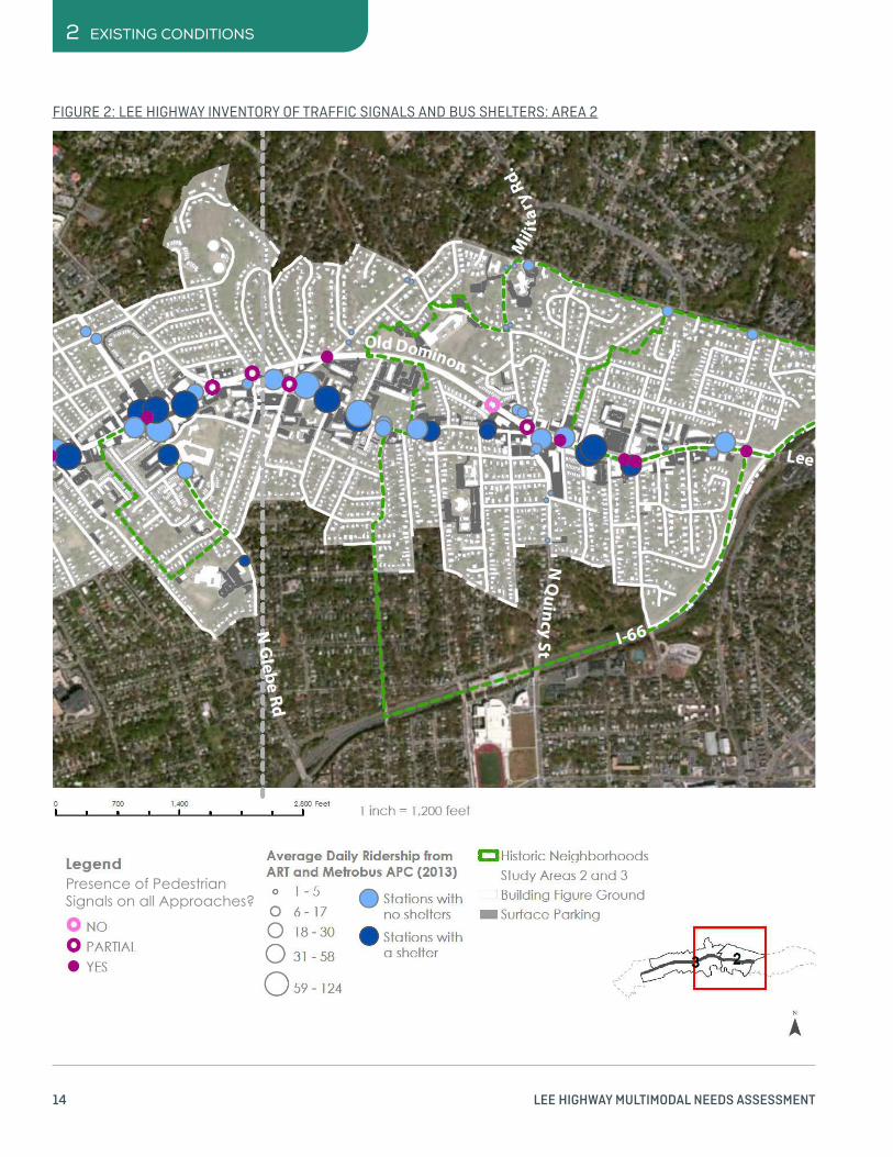
Figures 2 and 3 provide an inventory of bus shelter and traffic signals throughout the corridor with an assessment of current conditions and average daily transit rider boardings at each stop. In general, traffic signals throughout the corridor are functional, but aging. All traffic signals have pedestrian signal indications, and only a couple of locations do not have crosswalks across all legs of the intersection (indicated as “partial” on Figures 2 and 3). Arlington County has a six-year plan developed in coordination with VDOT to upgrade most of the traffic signal equipment in the corridor and is methodically replacing the older span-wire signals to newer ones mounted on mast arms. Bus stop conditions in the corridor are also a mix of old and new, with many of the lower-volume stops consisting of only a flagpole indicator. As indicated in Figures 2 and 3, bus stop daily boardings range from just 1 per day up to 124 per day.
US 29 carries a fairly consistent average daily traffic volume between 20,000 and 25,000 vehicles per day throughout the study area. Traffic volumes are influenced by operational restrictions on parallel Interstate 66, where peak-direction, peak-period traffic is limited to HOV-2 (vehicles with two or more persons), motorcycles, and traffic to or from Dulles Airport.
TRAFFIC SAFETYThe Lee Highway corridor study area has experienced 449 reported vehicle crashes over a five-year period from July 1, 2009 through June 30, 2014. While this number may sound high, the crash rates (number of crashes divided by exposure – or the number of total vehicles on the road), does not by itself indicate a serious safety problem. The study area street grid is sufficiently robust in the study area that each crash is associated with, and most are influenced by, operations at a nearby intersection. Figures 4 and 5 show both the total distribution of crashes and the corresponding crash rates in terms of crashes per million vehicles (MV). The highest number of crashes occur at the intersections with Spout Run Parkway/Kirkwood Road, the adjacent I-66 ramps, and N. George Mason Drive, with between 48 and 58 crashes each, as indicated by the sizes of the circles on Figures 2 and 3. The highest crash rate in the corridor is also at the N. George Mason Drive intersection, with 0.93 crashes per MV. As a reference point, the top 25 highest intersection crash rates in the Northern Virginia District of VDOT have more than 1.90 crashes per MV. Additional information is provided in Appendix A.
None of the crashes in the five-year period resulted in a fatality, indicative of the generally low operating speeds in the corridor. About 72% of the crashes are multi-vehicle crashes involving either a rear-end or angle collision, an expected trend given the number of intersections along the corridor. Fairly few crashes involved a pedestrian (19) or a bicyclist (11). The pedestrian and bicyclist crashes are spread throughout the corridor. The highest clustering of crashes occurred at Lee Highway and North Glebe Road with four crashes (two pedestrian and two bicyclist). The intersection of Lee Highway Harrison Street had three such crashes (all pedestrian). Several other locations had either one or two pedestrian or bicyclist crashes. The distribution of pedestrian and bicyclist crashes does not suggest any particular systemic cause or countermeasure. Only 3% of the crashes are associated with alcohol or drug impairment.
14 LEE HIGHWAY MULTIMODAL NEEDS ASSESSMENT
2 EXISTING CONDITIONS
FIGURE 2: LEE HIGHWAY INVENTORY OF TRAFFIC SIGNALS AND BUS SHELTERS: AREA 2
Presence of Pedestrian Signals on all Approaches?

15 LEE HIGHWAY MULTIMODAL NEEDS ASSESSMENT
EXISTING CONDITIONS 2
FIGURE 3: LEE HIGHWAY INVENTORY OF TRAFFIC SIGNALS AND BUS SHELTERS: AREA 3
Presence of Pedestrian Signals on all Approaches?

16 LEE HIGHWAY MULTIMODAL NEEDS ASSESSMENT
2 EXISTING CONDITIONS
FIGURE 4: LEE HIGHWAY INTERSECTION CRASH RATES: AREA 2
Million Vehicles

17 LEE HIGHWAY MULTIMODAL NEEDS ASSESSMENT
EXISTING CONDITIONS 2
FIGURE 5:LEE HIGHWAY INTERSECTION CRASH RATES: AREA 3
Million Vehicles

18
This page intentionally left blank.

19
STRENGTHS, WEAKNESSES, OPPORTUNITIES, AND THREATS 3

20 LEE HIGHWAY MULTIMODAL NEEDS ASSESSMENT
The project team’s first step in conducting the Lee Highway Complete Streets Assessment was to conduct an analysis of strengths, weaknesses, opportunities, and threats (SWOT) influencing the corridor. The team reviewed plans, traffic volume data, pedestrian and bicycle activity, bus stop boardings and alightings, right-of-way opportunities and constraints, and utilities information as described in the prior section.
These data sources yielded a first draft of the SWOT analysis that the project team supplemented with comments made by area residents during community meetings held in the fall of 2014 and winter of 2015. As such, it reflects both professional judgement and the collective knowledge of people living and working near the corridor.
The full results of this analysis are presented in Appendix B. A summary is presented in this section. The project team studied strengths, weaknesses, opportunities, and threats for each of these categories:
ACCESSWhat are the issues in this corridor that affect the ability of people to access their everyday needs and the land uses along the corridor, by all modes of transportation?
MOBILITYWhat are the issues in this corridor that hinder the ability of people to move through the corridor with a tolerable level of delay, by all modes of transportation?
SAFETYWhat are the issues in this corridor that affect the safety of people traveling by all modes of transportation?
LAND USEWhat are the land use issues in this corridor that affect transportation and the potential to make Lee Highway a more complete street?
OTHERWhat other issues affect transportation and the potential to make Lee Highway a more complete street?
STRENGTHSOne of the corridor’s greatest strengths from a transportation perspective is the network of streets on either side of Lee Highway. The robust grid supports walking and biking and gives motorists multiple routes for traveling between their homes and destinations. The corridor also is served by multiple local and regional bus routes, including the Metrobus 3 series of routes that both serve Lee Highway directly and connecting ART routes that provide access to several Metrorail Orange/Silver Line stations. While Lee Highway is fairly wide in most section for pedestrians that wish to cross, the major intersections are signalized with pedestrian signals and highly visible crosswalks.
The corridor benefits from a series of compact, mixed-use development districts that include many neighborhood-oriented shops and services in close proximity to a high number of residences, facilitating achievement of community needs with short-distance trips. The retail businesses, many of which are locally-owned and unique to the area, are another major strength. They give people plenty of reasons to want to walk, bike, ride, or drive to the corridor. They make Lee Highway more than a through corridor. It’s also a destination. The businesses are highly accessible to the neighborhoods on either side of the road.
The people that live and work on Lee Highway are another strength. They are engaged, care deeply about the corridor, and have shared many ideas for how to make it a better corridor. They are well organized through the Lee Highway Alliance. The Lee Highway Alliance Briefing Book provides a robust description of community context which served as a background for this more technical and transportation-oriented study:
arlingtonva.s3.amazonaws.com/wp-content/uploads/
sites/31/2015/02/Lee-Highway-briefing-book-final-022415.pdf
3 SWOT
SWOT ANALYSIS

21 LEE HIGHWAY MULTIMODAL NEEDS ASSESSMENT
SWOT 3
21 LEE HIGHWAY MULTIMODAL NEEDS ASSESSMENT
The robust street grid provides multiple options for low-stress bicycle route connectivity.

22 LEE HIGHWAY MULTIMODAL NEEDS ASSESSMENT
3 SWOT
WEAKNESSESThe primary weakness of the corridor from a complete-streets perspective is that the auto-oriented design of Lee Highway, and many of its abutting properties, limits the number of trips that people feel comfortable making on foot, by bike, or via transit.
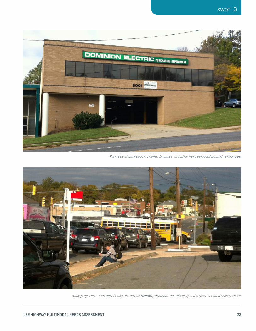
While the extent of transit service is a strength, the status of transit facilities in the corridor is a weakness. Many of the bus stops are rudimentary, lacking a shelter and in some cases also lacking a bench. People at public meetings expressed some confusion about where to catch certain routes. On the pedestrian and bicycle side, there are many gaps in the network. Bike lanes are spotty and there are a few key missing sidewalk segments and crosswalks .
Most of the development in the corridor is auto-oriented from both design and operational perspectives. Many commercial properties not only serve the immediately adjacent neighborhoods but the corridor is also the nearest commercial resource for a large portion of North Arlington. Many customers do at least need auto access. The historic nature of many strip retail centers results in parking lots, rather than storefronts, adjacent to the street and even several newer shopping centers from Cherrydale to N. Harrison Street are oriented primarily towards auto-access for their customer base, dominating shopping center appearance and function. Further, even many properties with good street frontage often orient their entrances to the parking lot and turn their back to Lee Highway from an operational perspective .
Off-street surface parking is plentiful within the corridor. As indicated in the base mapping for Figures 2 through 5, the commercial properties generally have more space dedicated to pavement than to the building footprint, fairly typical for suburban land use patterns. However, parking demand and supply are unevenly distributed throughout the corridor both by location and time of day. Adjacent properties with different uses have different parking demand peaking characteristics, and while shared parking arrangements could provide a logical solution, administrative requirements, small parcel sizes and grade changes all complicate shared parking implementation.
Many of these weaknesses could be improved within the existing right of way that is dedicated to the road and sidewalks. However, addressing some of the weaknesses would require additional right of way. This brings up another major weakness. The right of way is severely constrained in this corridor. As a result, the community will need to make tradeoffs among different design treatments. The ideal scenario may not be possible because there may not be enough right-of-way to fit all the desired street improvements.
There are many design features that contribute to the auto-oriented nature of the corridor. These include:
> Wide travel lanes in some places
> Long pedestrian crossings, typically without a median refuge
> High-mounted lighting oriented towards illuminating the street rather than the sidewalk
> An abundance of parking and the placement of parking between the sidewalk and buildings
> The prevalence and length of curb cuts, which creates many potential conflict points between pedestrians and vehicles, and also supports fast turns from Lee Highway into parking lots
> Narrow sidewalks with little or no buffer from adjacent travel lanes
> Lack of street trees, which could provide shade for pedestrians and people waiting for the bus, while also creating a buffer between fast traffic and the sidewalk
23 LEE HIGHWAY MULTIMODAL NEEDS ASSESSMENT
SWOT 3
Many properties “turn their backs” to the Lee Highway frontage, contributing to the auto-oriented environment.
Many bus stops have no shelter, benches, or buffer from adjacent property driveways.

24 LEE HIGHWAY MULTIMODAL NEEDS ASSESSMENT
3 SWOT
The prevalence of restrictions on private property speaks to the challenges of providing sufficient parking by location and time of day.
Right-of-way constraints limit the ability to construct improvements that require additional space.

25 LEE HIGHWAY MULTIMODAL NEEDS ASSESSMENT
SWOT 3
OPPORTUNITIESDespite these weaknesses and the challenges to overcoming them, there are plenty of opportunities. First, the street grid described earlier and the high number of local businesses that are oriented towards serving the adjacent neighborhoods means there is likely latent demand for walking and biking. There are many people that live within or in close proximity to the corridor. Creating a more inviting, comfortable, and safe place to walk, bike, roll, and ride may lead to notable gains in the use of those modes.
Much of the development in the corridor is dated in both style and function, which contributes to property owner interest in redevelopment. As properties redevelop, opportunities are created to address some of the corridor weaknesses, both by improving the design and function of adjacent parcels to emphasize multimodal access and reduce the level of auto-orientation as well as by facilitating investment in the corridor in both the private and public realms through the County’s proffer process. The current assessment of corridor needs also provides an opportunity to revisit the County’s plans and processes to further encourage transit and pedestrian-oriented development form, facilities, and amenities.
The corridor is also close to the expanding Capital Bikeshare system. New stations on Lee Highway could substantially improve the neighborhood’s connectivity to other parts of Arlington, Falls Church, and even across the river into Georgetown and other parts of Washington. The close proximity makes the Lee Highway corridor a logical place for expansion.
The target speed for the corridor presents another good opportunity to translate some of the latent demand into actual pedestrians, bicycle, and transit users. The speed limit for the corridor is 35 miles per hour or slower. But Lee Highway’s design supports a much higher speed in some places, especially when traffic is light. There may be opportunities to calm traffic in some places in order to increase comfort and perceived safety, attracting more people to walk and bike. Continued opportunities exist to expand the grid of low-stress bicycle routes, including consideration of bicycle boulevards on parallel facilities such as 26th Street.
There are also a few opportunities to improve intersections and create new open spaces or even convert some land used for roadway to tax-generating purposes. The Old Dominion/Lee Highway intersection is a prime example.
THREATSPerhaps the greatest threat is the competing demands on Lee Highway. It functions as both a key east-west corridor in Arlington while also being the Main Street for several adjacent neighborhoods. There is an inherent tension between these two roles. The auto-oriented design, which aids the east-west commuting traffic and other through traffic, reduces comfort and safety for pedestrians and bicyclists. However, attempts to calm traffic and reallocate the right-of-way space among different modes could push some traffic onto adjacent routes or side streets. These competing demands are embodied by the need for collaborative planning efforts for US 29 between VDOT and Arlington County, given VDOT’s ownership role and Arlington County’s management of operational elements such as traffic signal timing and transit services, as well as land use planning and zoning authority.
Another threat is the amount of space given to impervious surfaces. A lot of space along and near Lee Highway has been given over to roads, parking lots, buildings, and other impervious surfaces. As a result, there is less land available to absorb storm water and more of it finds its way into the Potomac River, carrying pollutants along with it.
Another major issue is the capacity for development along the corridor. The corridor is nearly built out. This limits the potential for new development to cover the cost of improvements to Lee Highway and side streets. It also means that new development will likely need to be higher density, which is cause for concern among many residents, and will also mean that multi-modal measures will need to be put in place to mitigate higher travel demand.

26
This page intentionally left blank.

27
MULTIMODAL ACCESSIBILITY 4

28 LEE HIGHWAY MULTIMODAL NEEDS ASSESSMENT
4 MULTIMODAL ACCESSBILITY
A primary value of the Lee Highway Corridor is as the local community’s “Main Street”. A Main Street environment works best when there are both attractive destinations for patrons to visit and a sufficient amount of nearby homes within walking or biking distance. Following the SWOT analysis, Renaissance conducted a Multimodal Accessibility (MMA) analysis to identify areas in the corridor that might be most suitable for pedestrian and bicycle improvements based on the destinations for retail trips and the amount of residential development available to generate those types of customers.
“Complete streets” describes an approach to designing facilities that accommodates all users, regardless of transportation mode. Traditionally transportation planning has been concerned with mobility. Mobility is typically provided by designing facilities that allow for high travel speeds. As a result, urban planning spent much of the last 70 years building wider and faster streets and highways that could accommodate a large number of cars and trucks. This approach was taken in many places regardless of the context. While Lee Highway supports more foot and bike traffic than many arterial roads in the United States, it still exhibits elements of auto-oriented design meant to increase mobility for cars.
Today many communities are taking the complete streets approach to remaking older facilities like Lee Highway. But the tools for evaluating different strategies for building a complete street (such as a new sidewalk or bike lane) are
much less advanced than the tools for building a network of highways for cars. In order to evaluate the types of improvements that create a complete street, urban planners are turning their attention to accessibility. Accessibility is mode neutral. It is about how easily a person can reach their daily destination and needs. Mobility, represented by speedy travel, is one approach to improving access. But proximity and accommodating all modes of travel is also a legitimate approach. Designing the built environment to make walking and biking more convenient helps improve accessibility. This outcome is achieved through deliberative land use planning efforts to bring origins and destinations closer to each other and transportation planning efforts to connect those land uses with infrastructure that makes walking and bicycling more attractive.
Renaissance Planning has developed a tool, called Multimodal Accessibility, which enables urban planners to study how accessible a place is to all modes and to see how different transportation improvements or land use changes will influence accessibility and even change the travel modes that people are choosing to use. This approach is based on the guidance in NCHRP Report 770, “Estimating Bicycling and Walking for Planning and Project Development: A Guidebook”:
onlinepubs.trb.org/onlinepubs/nchrp/nchrp_rpt_770.pdf

29 LEE HIGHWAY MULTIMODAL NEEDS ASSESSMENT
MULTIMODAL ACCESSIBILITY 4
Figure 6 introduces the concept of MMA-walk scores to describe the attractiveness of walking to retail destinations as a function both of the number of destinations and the walking distance to reach them. The concept is similar to the Walkscore concept popularized by the real estate industry, but with a couple of key differentiators. First, the MMA-walk scores in Figure 6 reflect the number of independent neighborhood-serving retail establishments that can be walked to with a decay curve that reflects the value of walk-access time based on recent MWCOG household travel surveys. For instance, 100% of the home-based non-work (HBNW), walk trips (excluding school trips) in the region are at least a minute in length, so a local store that is literally next door counts as “a full destination” or one MMA point. About 55% of the regional HBNW walk trips are 10 minutes or more in length, so a local store that is a 10-minute walk counts as about 0.55 MMA points. But only about 20% of the regional HBNW walk trips are more than 20 minutes in length, so a local store that is a
20-minute walk counts as only 0.20 MMA points. A continuous curve reflecting this “decay” in the value of time connects all the possible walk trip lengths and all possible trips are aggregated into census blocks. Second, we retain these raw values for synthesis with similar values for transit and auto trips to develop mode share estimates rather than normalizing them into a 0 – 100 point scale.
As Figure 6 indicates, the most attractive walking destinations from a retail perspective are actually in the segments of the corridor between Glebe Road and Harrison Street. These are locations with a high number of smaller retail establishments. Research has shown the number of establishments has a stronger relationship to retail trip mode share than the total square footage of retail, likely due to the auto-oriented design of larger retail establishments. Research also indicates that many people will walk, bicycle, or take transit for shopping trips; they tend to spend less per trip but make more frequent trips.
FIGURE 6: RETAIL ESTABLISHMENTS AND WALK TRIP ATTRACTIVENESS
THE RELATIVE ATTRACTIVENESS OF CORRIDOR DESTINATIONS

30 LEE HIGHWAY MULTIMODAL NEEDS ASSESSMENT
Figure 7 shows the location of housing units in the corridor and their propensity to generate walk trips based on the availability of walking, auto, and transit options, the locations of alternative destinations, and their relative attractiveness. The concept is similar to that described for Figure 6, with separate MMA scores for home based non-work (HBNW) trips for each mode, and a synthesis of those trips in a simple model to predict mode shares.
The size of each pie chart on Figure 7 reflects the number of households in each census block. From this perspective, the
greatest potential number of trips are likely to be generated towards the east end of the corridor in the Cherrydale, Old Dominion, and Glebewood neighborhoods. (Note that the pie charts are not adjusted for the size of the census block, so there is a slight skewing of Figure 7 towards blocks with larger acreages, but the total surface area of all pie charts can allow the viewer to adjust visually for that effect).
The distribution of the slices of pie in each pie chart show the estimated mode split for HBNW trips. Perhaps of most immediate note is that transit trips are virtually absent from
4 MULTIMODAL ACCESSBILITY
FIGURE 7: RESIDENTIAL POPULATION AND WALK TRIP GENERATION
THE RELATIVE PROPENSITY OF HOUSEHOLDS TO GENERATE WALK TRIPS

31 LEE HIGHWAY MULTIMODAL NEEDS ASSESSMENT
the chart, which is not particularly surprising given that many shopping trips are made outside peak transit-operating hours and that while bus service coverage in the corridor is robust, the service frequencies are low. thereby making discretionary trips such as shopping or dining not conducive to transit use. On the other hand, many shopping trips are made in small groups so that the number of auto passengers is, in most cases, the second highest mode after auto drivers.
The orange portions of each pie show the estimated percentage of walk trips starting from households in each census block. One key point of explanation is that while the focus of the analysis is on neighborhood-serving retail and school trips are excluded from the “non-work” definition, local social and recreational trips are still included in the definition so that there is some baseline walk mode share throughout the corridor (and in fact, the whole region, from which the household survey relationships are derived). A second point is that while the differences among charts may not look that different at first glance, closer inspection demonstrates the linkage between the attractions in Figure 6 and the pie charts in Figure 7. Those places that have a high number of retail attractions, or destinations, within walking distance (as decayed by travel time) can be expected to have walk mode shares in the 20-25% ranges. Those places with few destinations can be expected to have walk mode shares closer to 15%.
WHAT DOES THIS TELL US?We have two different types of places in the corridor:
> Places with desirable walk-trip destinations in the western half of the corridor
> Places with a high number of potential walk-trip origins in the eastern half of the corridor.
For the near term (Tier 1 and 2) improvements, both these places will benefit the most from investments in walking and bicycling infrastructure and programs.
Over the long term, including the fall 2015 Visioning process, a key functional element of land use planning would be to seek planning and zoning tools and incentives that facilitate an increase the number of retail opportunities in the eastern end of the corridor and to increase housing opportunities in the western half of the corridor. Implementing these land use changes will likely result in a notable increase in walking and bicycling mode share.
MULTIMODAL ACCESSIBILITY 4

32
This page intentionally left blank.

33
SUGGESTED IMPROVEMENTS 5

34 LEE HIGHWAY MULTIMODAL NEEDS ASSESSMENT
5 SUGGESTED IMPROVEMENTS
The SWOT and multimodal accessibility analyses reinforce the need for some changes to the corridor to make it more attractive for non-auto travel while also maintaining its role as a key east-west mobility corridor. This section introduces the types of improvements that are suggested in the near-term and mid-term . These suggested improvements require additional community input and review and concurrence by both Arlington County and VDOT before they can be implemented. The improvements are divided into four categories:
> TIER 0: Describes improvements that are already underway or about to be implemented.
> TIER 1: Describes improvements that Arlington County or VDOT can implement in the near-term or mid-term regardless of the long-term plan and vision for the Lee Highway corridor.
> TIER 2: Describes improvements that should be implemented in the near-term or mid-term coordination with private sector redevelopment either through the site plan layout or proffer system.
> TIER 3: Describes longer-term and larger-scale improvements that would be defined as part of the vision and long-range plan for the corridor.
CONSIDERING NEAR-TERM FEASIBILITYThe consideration of near term and longer-term improvements for the corridor reflects a series of considerations:
> Near term projects should minimize impacts to adjacent businesses, at least until the corridor Visioning process is completed and the corridor constituency has an opportunity to weigh in on which resources in the corridor are most desirable for preservation and which are most ready for redevelopment over time (including potential removal of existing structures and potential utility relocations as well as a sense of community infrastructure needs in both transportation and other civic arenas).
> Longer term private property redevelopment increases the potential for implementation of longer term public infrastructure needs through the proffer process.
> Most constituents agree that it is undesirable to implement a near-term project only to see it ripped out for a different long term project design in the next several years.
The corridor right-of-way constraints significantly limit the types of systemic typical sections that could be implemented in the corridor. The current traffic volumes of 20,000 to 25,000 ADT are indicative of the need for a four lane roadway. While Arlington County has done an admirable job of increasing economic development in its Metrorail corridors while maintaining historic traffic volumes, the most recent MWCOG model forecasts also indicate a slight increase in traffic on US 29 over time associated with the current land use pattern. This topic could perhaps be revisited depending on the land use and multimodal system design scenarios contemplated in the Visioning charrettes this fall. However, for the near term conditions, a lane repurposing scenario on US 29 is not feasible.
Similarly, the potential for adding any significant width to the US 29 typical section is limited to the very few areas of the corridor where adjacent land use elements (whether buildings or parking) do not constrain the very edge of the right-of-way. Figure 8 provides a graphical example of the constraints in the corridor using the Glebewood area of Lee Highway at Glebe Road as an example. Most of Lee Highway has been laid out according to a fairly consistent 70’ wide right-of-way (indicated by the blue lines) consisting of the following elements:

35 LEE HIGHWAY MULTIMODAL NEEDS ASSESSMENT
SUGGESTED IMPROVEMENTS 5
FIGURE 8: TYPICAL RIGHT-OF-WAY CONSTRAINTS
A potential retrofit to add bicycle lanes, a more consistent left-turn lane treatment, and minimally desirable sidewalk and landscape strip widths might require about 92’ in width (even allowing for a reduction in motor vehicle turn lane lengths facilitated by a wider median and the bicycle lanes):
Figure 8 shows the 92’ right-of-way with a red line, demonstrating the property and building impact challenges associated with typical section improvements.
Blue line: existing 70’ right-of-way Red line: potential 92’ right-of-way

36 LEE HIGHWAY MULTIMODAL NEEDS ASSESSMENT
TABLE 1: CONCEPTUAL TRADEOFFS AMONG COMPLETE STREET ELEMENTS
Other typical-section improvements, such as adding a bicycle lane, also require minimum width and length dimensions to be most effective. Table 1 presents a comparison of the different types of geometric improvements considered in the Opportunities section of the SWOT analysis summarized above and detailed in Appendix B and the general width and length of each needed for minimal effectiveness , as well as particular synergies or conflicts between the different types of improvements. For instance, the concept to provide on-street parking to support selected properties during off-peak traffic periods may be an effective means to address some of the corridor’s parking constraints and calm off-peak traffic speeds without any new physical space requirements. However, it essentially precludes the development of a marked bicycle lane as it would entail cars parking in the marked bicycle lane.
The elements in Table 1 are listed in order of increasing additional width. Elements with the lowest typical section dimensional requirements (less than 4’ in width or less than 100’
in length) are highlighted in green, and those with the greatest typical section dimensional requirements (more than 10’ in width or 500’ in length) are highlighted in red. This shading points out the challenges in retrofitting the more substantial elements for bicyclist and transit vehicles in particular; they are not spot improvements and will likely involve property impacts unless and until those properties are redeveloped.
For this reason, this study considers systemic considerations such as transit queue jumpers and bicycle lanes as essentially “Tier 3” elements that should be considered, and potentially implemented, in conjunction with the future vision for the corridor; a vision that will not likely be established for many months (or perhaps years, depending on how much consensus-building and legislative changes would need to be involved to achieve that vision). The near-term (Tier 1 and 2) improvements, like most of the Tier 0 improvements, should be spot improvements that can be implemented with a minimal amount of impacts to real property or its access and circulation.
5 SUGGESTED IMPROVEMENTS
DESIRED ELEMENT BENEFITS CONCERNS
TYPICAL ADDITIONAL WIDTH
MINIMUM LENGTH FOR CONTINUOUS APPLICATION
PARTICULARLY COMPATIBLE WITH:
INCOMPATIBLE WITH:
Off-peak, on-street parking
Provide additional parking opportunities, buffer pedestrians, reinforce 30 MPH target speed
Safety of parking maneuvers, effect on traffic flow, peak period enforcement
0’ (within travel lane)
~100’ Bike lanes (due to time-of-day utilization)
Landscape panel with street trees (median or curb)
Buffer pedestrians, provide shade, accommodate signs/some utilities frame street
Adjacent retail visibility 4’ each panel ~100’ Median pedestrian refuge
Bicycle lane Improve on-road bicyclist comfort and visibility
Continuity and connectivity of on-road treatments
5’ each direction >500’ (depending on bikeway connectivity)
Off-peak parking (due to time-of-day utilization)
Median pedestrian refuge
Safety zone for two-phase crossing
Increase in total crossing length
6’ (if no median exists); 4’ (where monolithic median exists)
~15’ plus taper Median landscape panel
Left turn lane Reduces crash potential
Increases overall roadway width
10’ ~100’ plus taper
Bus queue jumper / dedicated lane
Improves transit service speed
Increases overall roadway width
12’ each direction >500’ plus taper
elements with lesser space requirements elements with greater space requirements

37 LEE HIGHWAY MULTIMODAL NEEDS ASSESSMENT
SUGGESTED IMPROVEMENTS 5
Arlington County and VDOT are continuing to coordinate on infrastructure upgrades in the corridor.
TIER 0Arlington County has already contributed substantial resources to improving the corridor. These Tier 0 improvements include plans to rebuild the 5 Points intersection (Lee Highway, North Quincy, Old Dominion, and Military); substantial planned enhancements in the vicinity of Lee Highway at North Glebe Road including new left turn lanes, a new bus shelter with a Next Bus system, moving utilities underground, and new crosswalk markings; plans to construct a missing sidewalk on Old Dominion Drive between Thomas Street and Fire Station 3; and plans to rebuild traffic signals and reorienting the crosswalk at Lee Highway and the Interstate 66 Westbound On Ramp. Additional information on the Tier 0 projects is available on the Arlington County website :
projects.arlingtonva.us/types/transportation/
TIER 1 AND TIER 2Tier 1 improvements fall into four broad categories, which include:
> Lee Highway Crosswalk and Sidewalk Improvements
> Side Street Crosswalk Improvements
> Lee Highway Spot Treatments
> Studies for Additional Improvements
A basic breakdown of the improvements is provided in the table below. A complete list and corresponding map is provided in Appendix C. Several guiding principles for each category are also included in the text below. Information on capital cost sources is provided in Appendix D.
The Tier 1 and Tier 2 improvements have a preliminary estimated implementation cost of about $2.7M, excluding any right-of-way costs (which are expected to be minimal). The studies described below have an estimated cost of approximately $0.4M.
Many of these improvements will help improve compliance with the Americans with Disabilities Act (ADA). These improvements shouid be coordinated with Arlington County’s ADA Transition Plan.

38 LEE HIGHWAY MULTIMODAL NEEDS ASSESSMENT
5 SUGGESTED IMPROVEMENTS
LEE HIGHWAY CROSSWALK AND SIDEWALK IMPROVEMENTSThe level of safety and comfort for pedestrians crossing Lee Highway is one of the most pervasive concerns expressed by community members.
NEW CROSSWALKS OF LEE HIGHWAYIn general, the crosswalks that cross Lee Highway at signalized intersections are in good repair. There are two locations where the study indicates additional or realigned crosswalks at non-signalized intersections are likely to be both appropriate and warranted:
> The N. Thomas Street intersection with Old Dominion Drive (with connection to the HB Woodlawn school site), where walk access is provided between a high-density residential neighborhood and a key civic institution. This crosswalk should include a rectangular rapid-flash beacon or high-intensity activated crosswalk (HAWK) signal, and a median refuge to increase visibility in an area of Old Dominion Drive where operating speeds tend to increase and few signals exist to create pedestrian gaps through platooning. The offset crosswalk on 16th Street (MD Route 390) north of Spring Street in Silver Spring, MD is one example of a successful midblock installation in a similar
location (a higher speed segment between more urban areas with vertical and horizontal curvature concerns)
> The N. Jefferson Street intersection with Lee Highway, where a quarter mile stretch between N. Harrison and N. Lexington Street contains fairly dense commercial activity along the north side and higher density housing on the south side. The opportunity also exists here to remove a westbound bus bay adjacent to, and along, the BP service station frontage, reducing the amount of pavement and reinforcing the 30 MPH target speed.
Two additional crosswalks would be restriped on both sides of the N. Culpeper Street intersection, where a shorter, more perpendicular crossing distance appears feasible without unduly affecting signal operations or adjacent property access and circulation. At several other skew-angle intersections in the study area there are complicating factors that would make similar crosswalk restriping more challenging.
Rectangular rapid flash beacons are recommended for consideration at the remaining unsignalized crosswalks in the study area .
Arlington County DES is in the process of developing a set of crosswalk guidelines, expected to be completed later in 2015. Initial review and coordination suggests that the recommendations in this report are essentially complementary to the draft guidance under development.
Unsignalized crosswalks should be candidates for rapid rectangular flashing beacons to improve visibility, particularly during nighttime.

39 LEE HIGHWAY MULTIMODAL NEEDS ASSESSMENT
SUGGESTEDED IMPROVEMENTS 5
UTILITY POLE RELOCATIONIn general, the utility poles along the corridor are located either in the strip between the curb face and sidewalk, or between the sidewalk and building frontage, so that a minimum of 4’ clear sidewalk width is provided. At four locations in the corridor the pole is within the sidewalk itself and should be relocated.
> South side, just east of I-66 off ramp
> South side, near N. Randolph Street
> South side, opposite Arlington Medical Building west of N. George Mason Drive (this location might adequately be addressed with sidewalk modifications rather than pole relocation)
> Southeast quadrant of Lee Highway / N. Harrison Street intersection
SIDEWALK WIDENINGAt two locations in the corridor, bus pullouts exist that can probably be converted to pedestrian/landscaping areas to visually narrow the roadway to reduce the target speed communicated to the motorist. These converted bus pullouts could be used to improve bus shelter facilities or to increase landscaping, including street trees to augment urban forest canopy, as no commercial establishments are located nearby to create a visual obstruction concern:
> Both sides, west of I-66 WB on-ramp
> North side, just west of N. Jefferson Street
TABLE 2: LEE HIGHWAY CROSSWALK AND SIDEWALK IMPROVEMENTS
IMPROVEMENT BENEFITS UNITSPER UNIT COST ESTIMATE
Install highly visible crosswalks (continental style) in the few locations lacking a highly-visible treatment
Improve visibility of places where pedestrians are likely to cross Lee Highway
4 $2,500 each
Install rectangular rapid flash beacons at several unsignalized intersections with high pedestrian volumes (if warranted by an engineering study)
Increase safety at the crosswalk at an unsignalized intersection
14 $22,250 each direction
Remove utility polls that obstruct the sidewalk right of way
To maintain an ADA accessible pathway 4 $10,000 each
Install missing sidewalk or increase the sidewalk width Fill the few missing gaps in the pedestrian network
660 feet $30 to $150 per foot
Add pedestrian islands to reduce crossing length (if warranted by an engineering study)
Increased safety and break long crossings into two segments
5 $13,500 each

40 LEE HIGHWAY MULTIMODAL NEEDS ASSESSMENT
5 SUGGESTED IMPROVEMENTS
TABLE 3: SIDE STREET CROSSWALK IMPROVEMENTS
SIDE STREET CROSSWALK IMPROVEMENTSWhile the marked crosswalks at each of the signalized intersections along Lee Highway and Old Dominion Drive are generally in good repair, many of the lower volume side streets are lacking either crosswalks or stop bars, contributing to the
auto-oriented environment. A consistent connection between the sidewalks on each side of Lee Highway communicates and defines a consistent pedestrian environment and realm, helps delineate the intersection, and (in conjunction with replacing missing stop bars) reinforces the stop-sign control for the side streets.
IMPROVEMENT BENEFITS UNITS PER UNIT COST ESTIMATE
Install new highly visible crosswalks with stop bars at 31 intersections (if warranted by traffic volume)
Better visibility for motorists of the crosswalk
42 $2,500 each
LEE HIGHWAY SPOT TREATMENTSSeveral spot improvements are listed in Table 4 below. Most require little additional explanation beyond the itemization listed and provided in greater detail in Appendix C. The most complex of these treatments, however, the reconstruction of the western Old Dominion Drive intersection, does warrant additional discussion. Note that the suggestion of four near-term future bikeshare stations in the corridor is based on efforts to date through social media to locate additional stations as well as general bikeshare station density appropriate for the current level of development activity. In the near-term, upgraded bus shelters should be provided at the Lee Highway intersections with North George Mason Drive and North Harrison Street, where existing ridership and/or levels of community activity suggest the investment is warranted. Elsewhere in the corridor, significant investment in transit shelters should be evaluated as part of the transit service study recommended in Table 5.
The study area includes two highly-skewed intersections between Lee Highway and Old Dominion Drive, reflecting older and newer alignments for the main pathway towards Washington DC as Arlington County developed over the past century. The eastern of these two intersections, Five Points in the Cherrydale neighborhood, is already fairly well developed on all quadrants with additional complete streets improvements already under design by the Department of Environmental Services. The study area’s westernmost intersection of Lee Highway and Old Dominion Drive in the Old
Dominion neighborhood is less fully developed from either land use or complete streets perspectives. The primary complete streets concern at this location is a high-speed three-lane diverge in the westbound direction of Old Dominion Drive, with the left lane continuing along US 29 (Lee Highway), the rightmost lane curving to the northwest towards Old Dominion Drive (VA 309), and the middle lane serving as a choice lane. The three lane section is approximately one-quarter mile in length, extending from Lorcom Lane to Old Dominion Drive.
The effectiveness of this diverge area is limited by downstream constraints. The two left lanes on Lee Highway reach the signalized intersection with the eastbound Old Dominion Drive alignment approximately 100 feet west of the diverge gore area and the rightmost lane on Old Dominion Drive merges into a single lane approximately 500 feet to the west of the diverge gore area. Despite the 30 MPH speed limit, the current design contributes to the overall context of an auto-oriented, higher speed environment; essentially indicating a continuation of the auto-oriented alignment of Old Dominion Drive from Cherrydale to Old Dominion rather than a transition into a new, pedestrian-oriented community.
Figure 9 shows a proposed concept for a near-term improvement incorporating the following elements:
> Replace the westbound diverge with a more conventional intersection design, with the two left turn lanes continuing onto Lee Highway and the rightmost lane continuing to the signalized intersection as a dedicated right turn lane to Old Dominion Drive.

41 LEE HIGHWAY MULTIMODAL NEEDS ASSESSMENT
SUGGESTEDED IMPROVEMENTS 5
FIGURE 9: PROPOSED CONCEPT FOR NEAR-TERM IMPROVEMENT TO LEE HIGHWAY / OLD DOMINION INTERSECTION
Legend
Building Figure Ground
3 2
y ¯0 180 36090 Feet 1 inch = 150 feet
LEE HIGHWAY / OLD DOMINION INTERSECTION
Lee Hwy
Old Dominon
Lee Hwy
Old Dominon
New road alignment
Replace third lane on Lee Highway with sidewalk / landscaping another 600 feet eastward to the Lorcom Lane intersection.
New crosswalkNew pedestrian ROW

42 LEE HIGHWAY MULTIMODAL NEEDS ASSESSMENT
TABLE 4: LEE HIGHWAY SPOT IMPROVEMENTS
> Convert the current diverge area to the pedestrian realm, creating a landscaping opportunity more accessible to the local community (although landscaping opportunities should focus on ground-cover elements to both maintain visibility to the adjacent commercial businesses on the north side of the roadway and adhere to Crime Prevention Through Environmental Design (CPTED) concepts. This may be a logical location for a bikeshare station and a more visible, pedestrian-oriented Old Dominion neighborhood gateway treatment.
> Extend the bike lane along westbound Old Dominion Drive so that it starts at the reconfigured Lee Highway intersection rather than at 22nd Street.
> Shorten the westbound right turn lane at its upstream end with a curb extension in the northwest corner of Old Dominion Drive and N. Wakefield Street, and add the missing crosswalk on the western leg of this intersection. Extend this pedestrian treatment (or something similar) for the remaining 600’ eastward to Lorcom Lane (thereby also reducing pedestrian crossing distances at the eastern N.
Wakefield Street and western Lorcom Lane crosswalks).
> Terminate N. Abington Street so that it does not intersect Lee Highway/Old Dominion Drive, considering both a plaza designed for emergency vehicle U-turns as required, or alternatively an emergency-vehicle-only access to Lee Highway
> Consider access management for the commercial properties on the north side of the roadway or extend the existing driveways to meet Lee Highway as part of the right turn lane design.
Some community members have expressed concern that this design could create delays for traffic using Old Dominion Drive to head into North Arlington. From a conceptual perspective, the design does not reduce functional capacity as it maintains the number of available travel lanes, and the new dedicated right turn lane can be operated with a nearly-continuous right-turn green arrow except for times when the north leg pedestrian signal phase displays a walk indication. Maintaining vehicular capacity for both directions of Old Dominion Drive traffic is the reason that the concept does
5 SUGGESTED IMPROVEMENTS
IMPROVEMENT BENEFITS UNITS PER UNIT COST ESTIMATE
Install new capital bikeshare stations on Lee Highway Bicycle access and connection to the system 4 $75,000 each
Install enhanced bus shelters with a next bus system Safety, protection from the elements, and make bus a more attractive option
4 $35,000 each
Replace street name signs with stylized signs reflecting neighborhood and corridor identity
Improved corridor identity 168 $500 each
Install gateway signs and enhance landscaping at entrances to Cherrydale, Glebewood Village, and the Commercial District between N. Harrison and George Mason Dr.
Welcoming and indicates to motorists they are approaching a pedestrian environment
6 $5,000 each
Reconstruct the Lee Highway and Old Dominion Intersection to eliminate “hot right” turns
Improve pedestrian safety and reduce vehicle speeds
N/A $250,000
Replace span-wire signals with mast-arm signals at the Lorcom and Culpeper intersections
Improve safety and aesthetics 2 $250,000 each

43 LEE HIGHWAY MULTIMODAL NEEDS ASSESSMENT
SUGGESTED IMPROVEMENTS 5
not include a new crosswalk for the east leg of the signalized intersection. The concept does shorten the right turn lane length from about 1,200’ to about 400’, so there may be some times of day where a right-turning vehicle will experience some queueing delay before accessing the right turn lane. During off peak periods, operating speeds for the right turn treatment would be reduced, but these delays (perhaps 5 to 10 seconds per vehicle due to occasional red-arrow signal phases with a protected pedestrian crossing and a slower turning speed) are considered appropriate for the environment. During project design, these concerns should be addressed and the results communicated to the community through traffic analysis and simulation.
In the long term, this concept could be modified to create perhaps a quarter-acre of additional developable property at the intersection should the long term plans seek to facilitate redevelopment of the fronting properties. Another quarter-acre of space would be created by the portion of the project between Lorcom Lane and N. Wakefield Street not explicitly shown in Figure 9. A similar treatment could also be applied in the long term on the south side of intersection to the west of N. Woodrow Street. The operational concerns with this skew angle diverge are of less concern as the relationship of land use and transportation conditions do not create the same perception along eastbound US 29 and the south side properties are much more fully developed so that access and circulation concerns for existing properties are far more complex.
STUDIES FOR ADDITIONAL IMPROVEMENTSArlington County should initiate planning studies for a series of more detailed plans to refine and inform the Tier 3 process. These studies can commence concurrently with the Visioning process in fall 2015. Some may help inform, and ultimately be dependent on, the outcome of that process (including planning and zoning changes).
INTEGRATED BICYCLE MARKINGS STUDYAs indicated in Table 1, right-of-way constraints preclude the addition of substantial bicycle lane implementation as a near-term improvement. Additional study is needed to define where the on-road bicycle lane needs are greatest, based on the level of bicycling demand and the level of bicycling stress both under current conditions and those that would result with the bicycle lanes in place. This study would also consider the means by which the lower-stress routes parallel to Old
Dominion Drive could best be leveraged as part of a complete on-road bicycle network.
The most significant gap in the overall bikeway network in the study area is the segment of Lee Highway between Old Dominion Drive and N. Culpeper Street through Glebewood. This segment is identified as a Planned On-Street Bike Route in the bicycle element of the Arlington Transportation Master Plan. It is also a segment with some of the most severe right-of-way constraints in the study area. During the Visioning process, alternative network concepts, such as the use of N. Columbus Street and N. 23rd Street (with a new traffic signal at the intersection of N. Glebe and N. 23rd), should be considered in addition to Lee Highway improvements. This approach would dovetail with the next study described.
TYPICAL SECTION ELEMENTS STUDYThis study would significantly expand upon the simple concept presented in Table 1 to consider the level of property impacts and changes in travel demand associated with the need or value of typical section improvements in the Visioning process. The study would incorporate the following elements, based on the principles of transect zone density and modal connectivity identified in the Multimodal System Design Guidelines published by the Virginia Department of Rail and Public Transportation:
www.drpt.virginia.gov/planning-and-commuter-programs/multimodal-guidelines/
> Confirmation of or refinement to the multimodal layered network. This process would confirm the primary mobility needs for bicyclists, transit vehicles, trucks, and other motor vehicles and identify the areas of greatest concentration for pedestrians. It would also facilitate quick exploration and screening of land use changes that would be needed to support more consistent corridor transit treatment improvements such as queue jumpers, a full BRT system, or any type of rail transit over the long term.
> Establishment of a modal priority for Lee Highway (as well as that for parallel roadways), considering the synthesis of local and regional needs and the appropriate Level of Service and Quality of Service for each mode.
> Identify and prioritize typical section improvements that consider both public and private realms in tandem, allocate space priorities based on modal priorities and other considerations, and consider the balance between design standard requirements and optimal treatments.

44 LEE HIGHWAY MULTIMODAL NEEDS ASSESSMENT
7 ft 6 ft 7 ft 8 ft 11 ftwith
shared lane
marking
(None)
This study would also consider benefits or impacts of additional Lee Highway right-of-way on the redevelopment potential for adjacent properties, considering the existing parcel size constraints, potential for property assembly, and lot depth constraints affecting redevelopment suitability.
OFF-PEAK ON-STREET PARKING STUDYThis study would consider parking allocation and demand within the study area and identify locations where off-peak period, on-street parking would most likely be utilized if it were provided. The study would also assess the institutional and operational constraints associated with implementing off-peak period parking, ranging from signing/marking, meters, and enforcement for everyday activities to transit stop operations, to effects on bicycle and motor vehicle operations. It would
consider implications for emergency vehicle operations. It would consider a wide range of time-of-day operations; for instance curb parking might only be considered to serve areas with significant Friday and Saturday evening patronage near eating places or places of worship during Saturdays or Sundays.
SIGNAL SYNCHRONIZATION STUDYA common concern in the LHA analyses was the level of side-street delays for both pedestrian and vehicular crossing of Lee Highway. In general, the signals in the corridor are already well timed for peak period flows as part of a coordinated signal system network. During off-peak periods, however, cycle lengths could likely be reduced to minimize side street/pedestrian delays, or more signals with minor streets could be allowed to double-cycle or float free from the network without
5 SUGGESTED IMPROVEMENTS
Example of Selecting Corridor Standards for a T-4 Major Avenue with Pedestrian Modal Emphasis.

45 LEE HIGHWAY MULTIMODAL NEEDS ASSESSMENT
significant adverse effects to mainline delays or safety. This study would also document minimum pedestrian crossing times and make adjustments as may be necessary. The study would further the interests of technology improvements that could implement transit signal priority (allowing transit vehicles to extend green times to reduce unnecessary delays at signals).
TRANSIT SERVICE CHARACTERISTICS STUDYArlington County is working with WMATA to convert the Metrobus 3 series to a local service operated by Arlington County Transit (ART). As part of this transition, consideration should be given to adjusting service headways during peak and off-peak periods, adjusting the span of service to incorporate longer operating hours, refining pulsing of buses between connecting routes, and optimizing the location of bus stops to streamline transit services and facilitate safe pedestrian crossings (as every regular transit rider needs to cross Lee Highway at least once on either their outbound or inbound trip).
SUGGESTED IMPROVEMENTS 5
Halls Hill Highview Park is an example of a civic landmark that might be further enhanced by a corridor-wide cultural wayfinding program.
CULTURAL WAYFINDING STUDYArlington County is a community of individual neighborhoods, each with a long and storied history. Similarly, Lee Highway is one of the original thoroughfares; once known primarily as the road from Georgetown to Fairfax. Lee Highway serves as the boundary between many of these communities, so typical gateway treatments like median landscaping or utility pole banners creates identity confusion more so than it does positive branding . The establishment of a unifying theme for the corridor that also celebrates the diversity and heritage of each neighborhood could be enhanced with a cultural wayfinding program that would include a common theme for the corridor but allow each community to develop its own identifying landmarks. Informational plaques or kiosks could be established in places like Halls Hill Highview Park that would combine the corridor-wide and local heritage into individual displays presented at a pedestrian scale.
SIGNAGE CLUTTER ENFORCEMENT STUDYOne of the primary concerns of area constituents is the amount of sign clutter, particularly associated with private business interests, along the roadway, including on sidewalks and parking areas. This study would examine current zoning regulations and enforcement practices and identify practical changes to reduce the amount of street furniture competing for visual attention, and sometimes physical space. Zoning Ordinance Parking Requirements Study: As is typical for many jurisdictions, Arlington County’s approach to on-site parking requirements is evolving. Historically, most properties have been required to “self-park”, which means that the site design for any land use development proposal must provide a minimum number of on-site parking spaces for the highest vehicular parking demand expected to occur on a regular basis. This type of requirement is intended to avoid spillover parking on adjacent properties or in adjoining neighborhoods, but often results in the creation of more parking spaces than are actually used on a regular basis, a condition which can limit redevelopment potential, particularly on

46 LEE HIGHWAY MULTIMODAL NEEDS ASSESSMENT
5 SUGGESTED IMPROVEMENTS
smaller parcels or at locations where ample nearby on-street parking is available. A review of the zoning ordinance would determine whether changes to the parking requirements for land uses in the Lee Highway corridor should be considered. The parking requirements study should be conducted in tandem with the shared parking study described below.
ZONING ORDINANCE PARKING REQUIREMENTS STUDYAs is typical for many jurisdictions, Arlington County’s approach to on-site parking requirements is evolving. Historically, most properties have been required to “self-park”, which means that the site design for any land use development proposal must provide a minimum number of on-site parking spaces for the highest vehicular parking demand expected to occur on a regular basis. This type of requirement is intended to avoid spillover parking on adjacent properties or in adjoining neighborhoods, but often results in the creation of more parking spaces than are actually used on a regular basis, a condition which can limit redevelopment potential, particularly on smaller parcels or at locations where ample nearby on-street parking is available. A review of the zoning ordinance would determine whether changes to the parking requirements for land uses in the Lee Highway corridor should be considered. The parking requirements study should be conducted in tandem with the shared parking study described below.
SHARED PARKING STUDYSome of the parking problems in the study area might be alleviated by better sharing of parking spaces by nearby properties. In most communities, the need to “self park” each property has led to limitations on smart growth due to property constraints, the creation of barriers between adjacent properties, and a proliferation of parking spaces that may reflect peak needs for each business as a stand-alone element, but do not reflect overall corridor parking demands. Shared parking is a way for multiple property owners to share parking to alleviate these concerns and may include institutional solutions such as cross-
Signage clutter is a corridor-wide concern.
Shared parking opportunities may incorporate both institutional and engineering solutions.

47 LEE HIGHWAY MULTIMODAL NEEDS ASSESSMENT
SUGGESTED IMPROVEMENTS 5
easements and engineering solutions such as creating connections between adjacent properties. This study would identify potential shared parking agreements, staring with a small series of community listening sessions for property owners/operators interested in gaining more information on current County plans and requirements, followed by assistance to small groups of adjacent property owners interested in pursuing shared parking agreements .
TIER 3The improvements that fall into these categories are either expected to be implemented through the development process or in the long-term. Arlington County, working with the community, is likely to identify many of the items that fall under this category as it crafts a vision and long-term plan for the corridor. However, some of the items identified in this assessment also fall into Tiers 2 and 3. These include moving utilities underground, installing pedestrian scale lighting, and introducing car sharing.
TABLE 5: STUDIES FOR ADDITIONAL IMPROVEMENTS
IMPROVEMENT BENEFITS UNITSPER UNIT COST ESTIMATE
Study an integrated on-road network of bicycle lanes and sharrow markings
To ensure that proper treatment is applied given the right-of-way restrictions, traffic volume, and speed
N/A $25,000
Study the need for typical section elements, including additional left turn lanes, landscaped median/sidewalk panels, wider sidewalks, bicycle lanes, and on street/off peak parking (in conjunction with scenarios for different land use/zoning and setback recommendations)
To improve safety N/A $250,000
Study feasibility of allowing on-street parking on portions of Lee Highway during off-peak hours
To accommodate parking demand without building new spaces and to provide a buffer between traffic and the sidewalk
N/A $15,000
Study synchronizing traffic signals and retiming signals, including adaptive traffic signal control and transit system priority treatments to reflect current traffic patterns. Confirm appropriate pedestrian crossing clearances and consider longer pedestrian crossing times
Ease traffic flow in the corridor, improve transit travel times, and accommodate additional multimodal demand
N/A $15,000
Study transit service operating characteristics along the corridor to identify potential service expansion opportunities and streamline operations
Improve transit service for area constituents
N/A $30,000
Study a cultural heritage wayfinding program to establish themed informational exhibits celebrating the corridor history and neighborhood identification
Enhance pedestrian experience and promote tourism
N/A $10,000
Identify zoning/maintenance initiatives to modify/enforce sign/street furniture regulations and right of way mowing/trimming
Reduce visual clutter and improve signage visibility
N/A $5,000
Work with property owners to study shared parking and cross-easement opportunities
Improve parking utilization and access management
N/A $25,000

48
This page intentionally left blank.
49
APPENDIX A: CRASH DATA SUMMARY A

Appendix A. Intersection Crash RatesCrash data from 7/1/09 - 6/30/14
Cross Street Crashes
(East to West)N S E W Entering AADT Annualized * 5 years
Crash Rate /
MV
LEE HIGHWAY
Spout Run 57 22000 8500 25000 25000 40250 73,456,250 0.78
Interstate 66 48 10000 10000 25000 25000 35000 63,875,000 0.75
Kenmore 3 1000 1000 25000 25000 26000 47,450,000 0.06
Lincoln 3 1000 1000 25000 25000 26000 47,450,000 0.06
Monroe 7 1000 1000 25000 25000 26000 47,450,000 0.15
Nelson 5 1000 1000 25000 25000 26000 47,450,000 0.11
Oakland 7 1000 1000 25000 25000 26000 47,450,000 0.15
Pollard 9 1000 1000 25000 25000 26000 47,450,000 0.19
Military/Quincy/Quebec 24 5800 8700 25000 5000 22250 40,606,250 0.59
Randolph 2 1000 1000 5000 5000 6000 10,950,000 0.18
Stafford 1 1000 1000 5000 5000 6000 10,950,000 0.09
Thomas 2 1000 1000 5000 5000 6000 10,950,000 0.18
Utah 2 1000 1000 5000 5000 6000 10,950,000 0.18
Woodstock 3 1000 1000 5000 5000 6000 10,950,000 0.27
Woodrow 6 1000 1000 5000 5000 6000 10,950,000 0.55
Old Dominion 13 13000 1000 5000 20000 19500 35,587,500 0.37
Albemarle 8 1000 1000 20000 20000 21000 38,325,000 0.21
Glebe 35 15000 18000 20000 22000 37500 68,437,500 0.51
Buchanan 1 1000 1000 22000 22000 23000 41,975,000 0.02
Cameron 8 1000 1000 22000 22000 23000 41,975,000 0.19
Culpeper 15 1000 1000 22000 22000 23000 41,975,000 0.36
Dinwiddie 1 1000 1000 22000 22000 23000 41,975,000 0.02
Edison 27 1000 1000 22000 22000 23000 41,975,000 0.64
George Mason 58 7000 17000 22000 22000 34000 62,050,000 0.93
Harrison 35 9100 6300 22000 22000 29700 54,202,500 0.65
Illinois 8 1000 1000 22000 22000 23000 41,975,000 0.19
Jefferson 3 1000 1000 22000 22000 23000 41,975,000 0.07
Kensington 4 1000 1000 22000 22000 23000 41,975,000 0.10
Lexington 17 940 1900 22000 22000 23420 42,741,500 0.40
OLD DOMINION DRIVE (East to West)
Thomas 1 1000 1000 20000 20000 21000 38,325,000 0.03
Lorcom 20 8200 1000 20000 20000 24600 44,895,000 0.45
Upton/Vermont 9 1000 1000 20000 20000 21000 38,325,000 0.23
Wakefield 7 1000 1000 20000 20000 21000 38,325,000 0.18
TOTAL 449
Note: AADT values in italics reflect context-based estimates; other values from VDOT's 2013 Jurisdictional Report for Arlington County
AADT

APPENDIX B: SWOT MATRIX B

Appendix B – SWOT Matrix The following pages present the key strengths, weaknesses, opportunities, and threats as they relate to
the future of the Lee Highway corridor as a complete street. This SWOT analysis is presented in the
following four matrices. The information within each matrix is organized by:
Access – What are the issues in this corridor that affect the ability of people to access their
everyday needs and the land uses along the corridor, by all modes of transportation?
Mobility – What are the issues in this corridor that hinder the ability of people to move through
the corridor with a tolerable level of delay, by all modes of transportation?
Safety – What are the issues in this corridor that affect the safety of people traveling by all
modes of transportation?
Land Use – What are the land use issues in this corridor that affect transportation and the
potential to make Lee Highway a more complete street?
Other – What other issues affect transportation and the potential to make Lee Highway a more
complete street?
The SWOT matrix was developed through compilation of existing data, field reviews, conversations with
agency staff, and review of the Lee Highway Alliance SWOT meeting notes from fall 2014.

Table 1 ‐ Strengths
Finding Location
Access
1. Robust street grid in most segments Entire corridor except Old Dominion Drive (US 29) between Lorcom Lane and Military Road
2. Established bus routes Corridor wide
3. Occasional wide buffer between travel lane and sidewalk Example between Vermont and Utah Streets
4. Much better streetscape, trees, and lighting with a good feeling of enclosure for the pedestrian on east end of corridor
Cherrydale area
Mobility
5. Key east‐west arterial route for the county Corridor wide
Safety
6. Highly visible crosswalks in many locations (zebra/ continental with signage)
Major intersections
Land Use
7. Community‐oriented retail accessible to pedestrians and adjacent neighborhoods
Corridor wide
8. Variety of small, locally‐owned, non‐chain businesses Corridor wide
9. Historic buildings that add local character, such as Fire Station #8
Corridor wide
Other 10. Active and involved constituency Corridor wide
11. Strong and progressive government structure Corridor wide
12. Interest in redevelopment and potentially rezoning Corridor wide

Table 2 ‐ Weaknesses
Finding Location
Access 1. Significant amount of auto‐oriented
strip retail Corridor wide, concentrated near major intersections
2. Poor access management to retail (awkward and sometimes insufficient parking)
Retail strip locations
3. Many businesses turn their back to the Lee Highway frontage
Corridor wide
4. Rudimentary transit stops; majority of stops lack a shelter
Corridor wide. Example of stop at Glebe Road/Lee Highway, which has one of the highest boarding counts, but no shelter.
5. Frequency and travel time for bus service (15 minutes peak, 30 minutes off peak)
Corridor wide
6. Fairly wide lanes in the two‐lane segment
Between Old Dominion Drive and Quincy Street
7. Large number of closely spaced curb cuts
Corridor wide, more pronounced west of Old Dominion Drive
8. 70 acres of parkland along the Lee Highway corridor, but poor bike and pedestrian access and poor wayfinding signage
Corridor wide
9. Poor frequency of bus service on weekends
Corridor wide
10. Lack of direct bus routes to D.C. Corridor wide
Mobility
11. ADA noncompliant facilities Example of crosswalk with no curb cut on south side near Kensington
12. Obstructions in the sidewalk
Examples include lamp post just east of Harrison (south side), retail signs between Buchanan and N. Glebe (north side), and dealership cars just east of Monroe (north side)
13. Lack of bicycle facilities and signing Limited bike lanes except for Cherrydale, limited bicycle signing/marking
14. Traffic signal timing is insufficient at
some intersections to allow people to
cross and for traffic to get through the
intersection in one light cycle.
Examples include Lee/Old Dominion and Quincy
15. Lack of dedicated left turn lanes Corridor wide
Safety 16. Skew‐angle intersections Lee Highway at Old Dominion Drive
17. Rudimentary transit stops Corridor wide

Finding Location 18. Higher speed encouraged by design in
certain segments Examples include Old Dominion Drive at Stratford Park and school site and west of George Mason Drive
19. Narrow buffer between travel lanes and sidewalk
More pronounced west of Old Dominion Drive
20. Very long curb cuts in some locations Example just west of Quincy Street on south side
21. Sidewalk demarcation is poor at some curb cuts
Multiple locations
22. Jaywalking is common in some locations
Example: Near Lee Heights.
23. Difficult to make left turns from Lee Highway to side streets
Corridor wide
24. Lack of median that could be a planting strip and provide refuge for pedestrians that cannot cross the entire width of Lee Highway in one traffic light cycle
Corridor wide
25. Blind intersection due to hill Culpeper and Lee Highway
26. Conflicts between cars turning right and pedestrians crossing Lee Highway
Corridor wide
27. Bike lanes that abruptly end, which is especially problematic on a hill
Example: Pollard at Lee Highway
28. Long crosswalks across Lee Highway that are perceived as dangerous
Corridor wide
Land Use 29. Right of way constraints leave little
space for physical improvements in many places
Business frontage encroachment at Alpine Restaurant, Maywood and Glebewood Village historic districts, and Calloway UMC cemetery
30. Challenging grades between adjacent properties
Corridor wide
31. Housing affordability Corridor wide
32. Poor match of parking supply with parking demand (too much parking in some places, not enough parking in others)
Corridor wide
33. High number of banks and gas stations Corridor wide
Other 34. Many shallow, front loaded parcels Corridor wide
35. General lack of streetscaping Corridor wide, with the exception of Cherrydale
36. Sign clutter (commercial and regulatory)
More pronounced west of Old Dominion Drive. Example at intersection with Vermont St.
37. Auto‐oriented street lighting (high off the ground)
More pronounced west of Old Dominion Drive

Finding Location 38. Human scale street lighting, but the
auto oriented lighting has not been removed
Vicinity of Harrison Street
39. Influence of above=ground utilities / poles
Western end of corridor
40. Parallel parking for businesses next to the sidewalk, creating a sense the pedestrian is walking among cars
North side of Lee Highway near Harrison intersection
41. Lack of gateway signage for both the corridor and specific neighborhoods
Corridor wide
42. Lack of street trees, especially in planting strips between Lee Highway and sidewalks
Corridor wide
43. Confusion about which bus routes serve particular stops
Corridor wide
44. Potholes and rough surfaces Corridor wide
45. Overgrown landscaping Example: Lee Highway at Lorcom Ln & Spout Run

Table 3 ‐ Opportunities
Finding Location
Access 1. Potential for significant increase in walking
and biking with better and safer connections. Already fairly steady pedestrian traffic.
Corridor wide, between Lee Highway and adjacent neighborhoods
2. Potential for better interparcel connections Corridor wide
3. Potential to add Capital Bikeshare stations in the corridor
West of the current stations, which are east of Spout Run
Mobility
4. Traffic calming measures to bring speeds down to the target of 30 MPH or slower
Corridor wide
Safety 5. Bus shelter improvements Corridor wide
6. Reorient skew intersections to shorten
pedestrian crossing, communicate slower
target speeds, and create open space or
convert to tax‐generating parcels
Old Dominion Drive
Land Use 7. Many significant historic properties and
districts along corridor that lend support to the need for more context sensitive solutions
Cherrydale, Glebewood Village, and Maywood are all on the National Register of Historic Districts
Other 8. Engagement of the neighborhoods through
the Lee Highway Alliance Corridor wide

Table 4 ‐ Threats
Finding Location
Access / Mobility 1. Tension between the corridors function as a key
east‐west mobility corridor, but also a destination for surrounding neighborhoods.
Corridor wide
Safety 2. Auto‐oriented design and higher travel speeds for
both through and turning traffic movements reduces pedestrian comfort
Example at two‐lane westbound diverge to Old Dominion Drive from Lee Highway (north side)
Land Use
3. Level of zoning increase needed to incent
redevelopment may change community character
and increase traffic (even with a substantial mode
shift)
Corridor wide
4. Large amount of impervious surface cover in the sensitive Potomac River watershed
Corridor wide
5. The corridor is nearly built out, with little new development approved or in the pipeline, meaning that new development may not be a funding source for improvements.
Corridor wide
6. New development lacks a sense of place and is incompatible with historic buildings
Corridor wide, especially a concern in Cherrydale
7. High rise development. Many people that participated in public meetings prefer building 5 stories or less with step down zone to residential areas
Corridor wide
Other 8. Income inequality Corridor wide
9. Disinvestment in some properties Corridor wide
10. Residents’ concerns about change and managing change
Corridor wide
11. Concerns that Arlington County and VDOT may
have different values on roadway
function/purpose/needs
Not applicable
12. Tension between short‐term and long‐term
objectives Not applicable
13. Potential for more cut through traffic if mobility
declines on Lee Highway Corridor wide along streets that run parallel

APPENDIX C: SUGGESTED IMPROVEMENTS INVENTORY C

Appendix C - Benefits/Costs Summary for Potential Lee Highway Improvements
Lee Highway Complete Streets Inventory
Potential Improvement Benefits and Costs
5/12/15 DRAFT
TOTAL TIER 1 AND 2 ESTIMTATED CAPTIAL COST: $2,657,040
ESTIMATED COSTS FOR TIER 3 STUDIES $375,000
# Improvement Neighborhood Tier 0 Tier 1 Tier 2 Tier 3 Benefits Unit # Units Cost/Unit Cost Estimate
1-A
Construct a highly visible pedestrian crosswalk
(such as the ladder style) of Old Dominion Drive
at Thomas St to connect southside
neighborhoods to Stratford Park and the HB
Woodlawn School.
Cherrydale, Waverly
HillsX
New crossing in a long
stretch with now
crosswalk. Supports more
children walking or biking
to the park and school.
Crosswalks 1 $2,500 $2,500
1-BExpand the median island at the new Old
Dominion Drive/Thomas Street crosswalk.
Cherrydale, Waverly
HillsX
Safety. Provide refuge at
long crossingsIsland 1 $13,500 $13,500
1-C
Install rectangular rapid flash beacon at the Old
Dominion/Thomas St crosswalk (if warranted by
an engineering study).
Cherrydale, Waverly
HillsX
Increase safety at the
crosswalk at an
unsignalized intersection
Flashing
beacon2 $22,250 $44,500
2-A
Remove the bus bay at Lee Highway and N
Jefferson St (north side), adding a wider
sidewalk. (Could also potentially add
landscaping in space where sidewalk had been).
Leeway Overlee,
YorktownX
Reduce the crossing
distance, keep buses in
the traffic stream, and
reinforce the vehicular
target speed
Linear Feet of
Sidewalk
(with curb)
200 $150 $30,000
2-B
Construct a highly visible pedestrian crosswalk
(such as the ladder style) of Lee Highway at N
Jefferson St intersection. There is no crosswalk
for a 1/4 mile stretch between N Harrison and N
Lexington Streets.
Leeway Overlee,
YorktownX
Provide for a more visible
crossing space for
Tuckahoe Apts residents
to the bus stop.
Crosswalks 1 $2,500 $2,500
2-C
Install rectangular rapid flash beacon at new
crosswalk at N Jefferson St (if supported by
engineering study)
Leeway Overlee,
YorktownX
Increase safety at the
crosswalk at an
unsignalized intersection
Flashing
beacon2 $22,250 $44,500
3Construct sidewalk on Lee Highway between
Old Dominion and WoodstockWaverly Hills X
Fill a missing gap in the
sidewalk
Linear Feet of
Concrete
Sidewalk
220 $32 $7,040
4
Restripe crosswalks at North Culpeper Street
and Lee Highway to make them perpendicular
to Lee Highway travel lanes.
John M Langston XShorten the crossing
distanceCrosswalks 2 $2,500 $5,000
5
Install rectangular rapid flash beacon at existing
crosswalk at N Kenmore St (if supported by
engineering study)
Cherrydale and
MaywoodX
Increase safety at the
crosswalk at an
unsignalized intersection
Flashing
beacon2 $22,250 $44,500
6
Install rectangular rapid flash beacon at existing
crosswalk at N Nelson St (if supported by
engineering study)
Cherrydale and
MaywoodX
Increase safety at the
crosswalk at an
unsignalized intersection
Flashing
beacon2 $22,250 $44,500
7
Install rectangular rapid flash beacon at existing
crosswalk at N Buchanan St (if supported by
engineering study)
Old Dominion X
Increase safety at the
crosswalk at an
unsignalized intersection
Flashing
beacon2 $22,250 $44,500
8
Install rectangular rapid flash beacon at existing
crosswalk at N Edison St (if supported by
engineering study)
Yorktown X
Increase safety at the
crosswalk at an
unsignalized intersection
Flashing
beacon2 $22,250 $44,500
9
Install rectangular rapid flash beacon at existing
crosswalk at N Kensington St (if supported by
engineering study)
Leeway Overlee X
Increase safety at the
crosswalk at an
unsignalized intersection
Flashing
beacon2 $22,250 $44,500
10
Remove utility pole from sidewalk right of way
at Lee Highway just east of the I-66 East off
ramp
Lyon Village XMaintain an ADA
accessible pathwayUtility pole 1 $10,000 $10,000
11
Remove utility pole from sidewalk right of way
at Lee Highway between 5 Points and N
Randolph St
Cherrydale XMaintain an ADA
accessible pathwayUtility pole 1 $10,000 $10,000
12
Remove utility pole from sidewalk right of way
at Lee Highway opposite Arlington Medical
Building
John M Langston XMaintain an ADA
accessible pathwayUtility pole 1 $10,000 $10,000
13
Remove utility pole from sidewalk right of way
at Southeast quadrant of the Lee
Highway/Harrison intersection
Leeway Overlee XMaintain an ADA
accessible pathwayUtility pole 1 $10,000 $10,000
14Add pedestrian islands on Lee Highway at
Lorcom intersectionWaverly Hills X
Safety. Provide refuge at
long crossingsIsland 2 $13,500 $27,000
15Add pedestrian islands on Lee Highway at
Harrison
Yorktown and
Leeway OverleeX
Safety. Provide refuge at
long crossingsIsland 2 $13,500 $27,000
16
Install a curb cut with wheelchair ramp at the
Kensington St and Lee Highway crosswalk
(south side)
Leeway Overlee XMake the crosswalk ADA
accessible
Wheelchair
ramp1 $800 $800
Benefits/Cost Summary for Potential Lee Highway Improvements
The following improvements are for crosswalks of Lee Highway or sidewalks along it
Page 1 of 4

Appendix C - Benefits/Costs Summary for Potential Lee Highway Improvements
# Improvement Neighborhood Tier 0 Tier 1 Tier 2 Tier 3 Benefits Unit # Units Cost/Unit Cost Estimate
Benefits/Cost Summary for Potential Lee Highway Improvements
17Reduce the length of the curb cut on Lee
Highway just west of N Quincy (south side)Cherrydale X
Pedestrian safety and
comfort
Linear Feet of
Sidewalk
(with curb)
120 $150 $18,000
18 N Kenmore St (north and south side) Cherrydale and X Visibility to motorists Crosswalks 2 $2,500 $5,000
19 N Monroe St (south side) Cherrydale X Visibility to motorists Crosswalks 1 $2,500 $2,500
20 N Lincoln St (north and south side) Cherrydale and X Visibility to motorists Crosswalks 2 $2,500 $5,000
21 N Nelson St (south side) Cherrydale X Visibility to motorists Crosswalks 1 $2,500 $2,500
22 N Oakland St (north side) Maywood X Visibility to motorists Crosswalks 1 $2,500 $2,500
23 N Quebec St (south side) Cherrydale X Visibility to motorists Crosswalks 1 $2,500 $2,500
24 21st Rd. North (north side) Cherrydale X Visibility to motorists Crosswalks 1 $2,500 $2,500
25 N Randolph St (south side) Cherrydale X Visibility to motorists Crosswalks 1 $2,500 $2,500
26 N Stratford St (north and south sides) Cherrydale X Visibility to motorists Crosswalks 2 $2,500 $5,000
27 N Taylor Street (north and south sides) Cherrydale X Visibility to motorists Crosswalks 2 $2,500 $5,000
28 N Utah St (south side) Cherrydale X Visibility to motorists Crosswalks 1 $2,500 $2,500
29 N Tazewell Ct (south side) Waverly Hills X Visibility to motorists Crosswalks 1 $2,500 $2,500
30 N Thomas St (north side) Waverly Hills X Visibility to motorists Crosswalks 1 $2,500 $2,500
31 N Vermont St (south side) Waverly Hills X Visibility to motorists Crosswalks 1 $2,500 $2,500
32 N Thomas St and Old Dominion (south side) Waverly Hills X Visibility to motorists Crosswalks 1 $2,500 $2,500
33 N Upton St (north side) Donaldson Run X Visibility to motorists Crosswalks 1 $2,500 $2,500
34 N Vermont St (north side) Donaldson Run X Visibility to motorists Crosswalks 1 $2,500 $2,500
35 N Vernon St (north side) Donaldson Run X Visibility to motorists Crosswalks 1 $2,500 $2,500
36 Old Dominion Drive (north side) Old Dominion X Visibility to motorists Crosswalks 3 $2,500 $7,500
37 20th Rd North (south side) Waverly Hills X Visibility to motorists Crosswalks 1 $2,500 $2,500
38 N Albemarle St (north side) Old Dominion X Visibility to motorists Crosswalks 1 $2,500 $2,500
39 N Buchanan St (north side) Old Dominion X Visibility to motorists Crosswalks 1 $2,500 $2,500
40 N Columbus St (north side) Old Dominion X Visibility to motorists Crosswalks 1 $2,500 $2,500
41 N Culpeper St (north and south side) John M Langston X Visibility to motorists Crosswalks 2 $2,500 $5,000
42 N Cameron St (south side) John M Langston X Visibility to motorists Crosswalks 1 $2,500 $2,500
43 N Dinwiddie St (north side) John M Langston X Visibility to motorists Crosswalks 1 $2,500 $2,500
44 N Edison St (north and south side) John M Langston X Visibility to motorists Crosswalks 2 $2,500 $5,000
45 N Greenbrier Ct (two north sides) Leeway Overlee X Visibility to motorists Crosswalks 2 $2,500 $5,000
46 N Illinois St (south side) Leeway Overlee X Visibility to motorists Crosswalks 1 $2,500 $2,500
47 N Kensington St (north and south side) Leeway Overlee X Visibility to motorists Crosswalks 2 $2,500 $5,000
48 N Lexington St (north and south side) Leeway Overlee X Visibility to motorists Crosswalks 2 $2,500 $5,000
49Install a Capital Bikeshare Station at N Vermont
St and Lee HighwayWaverly Hills X
Bicycle access and
connection to systemStation 1 $75,000 $75,000
50Install a Capital Bikeshare Station at N
Woodstock and Lee HighwayWaverly Hills X
Bicycle access and
connection to systemStation 1 $75,000 $75,000
51Install a Capital Bikeshare Station at N Culpeper
and Lee Highway (Langston School)John M. Langston X
Bicycle access and
connection to systemStation 1 $75,000 $75,000
52Install a Capital Bikeshare Station at N Harrison
and Lee HighwayYorktown X
Bicycle access and
connection to systemStation 1 $75,000 $75,000
53Install enhanced bus shelters with Next Bus
system at N George Mason and Lee Highway
John M Langston
and YorktownX
Safety, protection from
elements, make bus more
attractive for riders
Bus Shelter 2 $35,000 $70,000
54Install enhanced bus shelters with Next Bus
system at N Harrison and Lee Highway
Leeway Overlee and
YorktownX
Safety, protection from
elements, make bus more
attractive for riders
Bus Shelter 2 $35,000 $70,000
55 Install a car sharing station near Glebe and Lee
Old Dominion,
Glebewood,
Waverly Hills
X
Provide opportunities for
people to live car free or
car light
Vehicles TBD TBD TBD
56
Move utilities underground along Lee Highway
in the N. Harrison and George Mason Drive
areas (from N Edison to N Jefferson St)
Yorktown, Leeway
Overlee, and John
M Langston
X X
Improve the aesthetics
and remove poles that
are obstacles for
pedestrians
Miles of
undergroundi
ng
0.5 $1,000,000 $500,000
57
Install pedestrian scale lighting in the
Glebewood Village area (from about Old
Dominion Drive to N. Columbus)
Old Dominion,
Glebewood,
Waverly Hills
X X
Safety and creates a more
inviting environment for
pedestrians
Streetlight 50 $5,000 $250,000
58Replace street name signs with stylized signs
reflecting neighborhood and corridor identityCorridorwide X
Improved corridor
identify
Street name
signs168 $500 $84,000
59Gateway treatment at entrances to Cherrydale
(Kenmore and N Quincy)Cherrydale X
Welcoming and indicates
to motorists they are
approaching a pedestrian
environment
Gateway Sign
and
Landscaping
2 $5,000 $10,000
60Gateway treatment at entrances to Glebewood
Village (N Columbus and Old Dominion)
Old Dominion,
Glebewood,
Waverly Hills
X
Welcoming and indicates
to motorists they are
approaching a pedestrian
environment
Gateway Sign
and
Landscaping
2 $5,000 $10,000
The following improvements are for Lee Highway side streets. At these locations, the improvement is a new highly visible crosswalk with stop bar
Additional Lee Highway Complete Streets spot improvements
Page 2 of 4

Appendix C - Benefits/Costs Summary for Potential Lee Highway Improvements
# Improvement Neighborhood Tier 0 Tier 1 Tier 2 Tier 3 Benefits Unit # Units Cost/Unit Cost Estimate
Benefits/Cost Summary for Potential Lee Highway Improvements
61
Gateway treatment at entrances to commercial
district at N Harrison and George Mason Dr (N
Edison and N Jefferson)
Yorktown, Leeway
Overlee, and John
M Langston
X
Welcoming and indicates
to motorists they are
approaching a pedestrian
environment
Gateway Sign
and
Landscaping
2 $5,000 $10,000
62Reconstruct the Lee Highway and Old Dominion
intersection to eliminate "hot right" turnsOld Dominion X
Improve pedestrian
safety, reduce vehicle
speeds.
- - - $250,000
63Replace span-wire traffic signals with mast-arm
traffic signals on Lee Highway at LorcomWaverly Hills X
Improve safety and
aesthetics- - - $250,000
64Replace span-wire traffic signals with mast-arm
traffic signals on Lee Highway at CulpepperJohn M Langston X
Improve safety and
aesthetics- - - $250,000
65Study an integrated on-road network of bike
lanes and sharrow markingsCorridorwide X
To ensure that proper
treatment is applied
given the right of way
restrictions, traffic
volume, and speed
Labor $25,000
66
Study the need for typical section elements
including additional left turn lanes, landscaped
median/sidewalk panels, wider sidewalks,
bicycle lanes, and on street/off peak parking - in
conjunction with scenarios for different land
use/zoning and setback recommendations.
Corridorwide X To improve safety Labor $250,000
67
Study the feasibility of allowing on-street
parking on portions of Lee Highway during the
off peak hours
Near the
neighborhood
commercial centers
X
To accommodate parking
demand without building
new spaces and to
provide a buffer between
traffic and pedestrians on
the sidewalk
Labor $15,000
68
Study synchronizing traffic lights and retiming
signals, including Adaptive Traffic Signal Control
and Transit System Priority treatments to
reflect current traffic patterns. Confirm
appropriate pedestrian crossing clearances and
consider longer pedestrian crossing times
Corridorwide X
Ease traffic flow in the
corridor, improve transit
travel times and
accommodate additional
multimodal demand
Labor $15,000
69
Study a cultural heritage wayfinding program to
establish themed informational exhibits
celebrating the corridor history and
neighborhood identification
Corridorwide X
Enhance pedestrian
experience and promote
tourism
Labor $10,000
70
Identify zoning / maintenance initiatives to
modify/enforce sign/street furniture
regulations and right-of-way mowing/trimming
Corridorwide XReduce visual clutter and
improve signage visibiliyLabor $5,000
71Work with property owners to study shared
parking and cross-easement opportunitiesCorridorwide X
Improve parking
utilization and access
management
Labor $25,000
72
Enhanced highly visible crosswalks on all legs of
the 5 Points intersection (Lee Highway at N
Quincy, Old Dominion, and Military)
Cherrydale X Visibility to motorists Crosswalks 5 $2,500 $12,500
73Install highly visible crosswalks on N Glebe at
Lee Highway (north and south sides)
Old Dominion and
GlebewoodX Visibility to motorists Crosswalks 2 $2,500 $5,000
74Install enhanced bus shelters with Next Bus
system at Glebe and Lee Highway
Waverly Hills and
Old DominionX
Safety, protection from
elements, make bus more
attractive for riders
Bus Shelter 2 $35,000 $70,000
75
Move utilities underground along Lee Highway
in the Glebewood Village area (from about Old
Dominion Drive to N. Columbus)
Old Dominion,
Glebewood,
Waverly Hills
X
Improve the aesthetics
and remove poles that
are obstacles for
pedestrians
Miles of
undergroundi
ng
0.3 $1,000,000 $300,000
76
Old Dominion Drive Sidewalk Improvements
Project. This project entails building a new
sidewalk about 1,800 feet in length on the
south side of Old Dominion Drive between
Thomas Street (west side) and Fire Station #3
(east side). It will close a sidewalk gap in a fairly
high density area.
Cherrydale X
Fill a key gap in the
pedestrian network,
improve access to school
and park on the
northside of Old
Dominion
Linear Feet of
Concrete
Sidewalk
1,800 $32 $57,600
Conduct studies to determine the best solutions for the following potential improvements
The following improvements are underway or in the design process (Tier 0 - not included in overall cost estimate)
Page 3 of 4

Appendix C - Benefits/Costs Summary for Potential Lee Highway Improvements
# Improvement Neighborhood Tier 0 Tier 1 Tier 2 Tier 3 Benefits Unit # Units Cost/Unit Cost Estimate
Benefits/Cost Summary for Potential Lee Highway Improvements
77
Rebuild the Five Points intersection with
shorter pedestrian crossings, reorient some
crosswalks (90 degree angle to travel lanes),
install new crosswalk on Lee Hgy (east side of
intersection), new bike lanes, and raised
crosswalk at right turn slip lane from Military
Road south to Old Dominion Drive west
Cherrydale and
MaywoodX
Reduces pedestrian
crossing distance,
provides new space for
bikes, and generally
improve safety while
signaling to motorists
that this is a shared space
- - - -
78
Rebuild traffic signals and reorient (90 degree
angle to travel lanes) crosswalk at Lee Highway
and the Route 66 Westbound On Ramp
Cherrydale and
MaywoodX
Improve traffic flow on
Lee Highway and reduce
crossing distance for
pedestrians
- - - -
79Remove bus bays on Lee Highway just west of
the Interstate 66 interchange
Cherrydale and
MaywoodX
To reduce bus delays and
provide more space for
pedestrians
Linear Feet of
Concrete
Sidewalk
1,000 $32 $32,000
80
Study transit service operating characteristics
along the corridor to identify potential service
expansion opportunities and streamline
operations.
Corridorwide XImprove transit service
for area constituentsLabor $30,000
Additional improvements (added after Draft 1
Page 4 of 4

SUGGESTED IMPROVEMENT LOCATOR MAP
LegendStudy Areas 2 and 3Building Figure GroundSurface Parking
3 2
¯0 740 1,480370 Feet 1 inch = 600 feet
I-66
Lee Hwy
N Q
uincy St
Lorcom
59
59
79
7978
7222
2119
20 1856
5
6
Crosswalk Intersection improvementFlashing beaconBus shelter enhancementSpot streetscape enhancementGeneral Streetscape enhancementBike/car sharing stationSidewalk treatment
NOTE: numbers correspond to specificimprovements detailed in the Suggested Lee Highway Improvements.
11
10

LegendStudy Areas 2 and 3Building Figure GroundSurface Parking
3 2
¯0 740 1,480370 Feet 1 inch = 600 feet
SUGGESTED IMPROVEMENT LOCATOR MAP
N Glebe
Lorcom
N Culpepper
60
57
62
63
23
24
2526
272829
1A
32
3031
34 3335
36
37
38
73
1C1C
74 74
49
50
55
Crosswalk Intersection improvementFlashing beaconBus shelter enhancementSpot streetscape enhancementGeneral Streetscape enhancementBike/car sharing stationSidewalk treatment
NOTE: numbers correspond to specificimprovements detailed in the Suggested Lee Highway Improvements.
17
76
3
14

LegendStudy Areas 2 and 3Building Figure GroundSurface Parking
3 2
¯0 740 1,480370 Feet 1 inch = 600 feet
Crosswalk Intersection improvementFlashing beaconBus shelter enhancementSpot streetscape enhancementGeneral Streetscape enhancementBike/car sharing stationSidewalk treatment
SUGGESTED IMPROVEMENT LOCATOR MAP
N GlebeOld Dom
inion
N G
eorge Mason
N Columbus
6057
5656
56
39
4041
42
43
4445
46
61
41315
7
7
8
54 54
53
5364 64
51
52
NOTE: numbers correspond to specificimprovements detailed in the Suggested Lee Highway Improvements.

LegendStudy Areas 2 and 3Building Figure GroundSurface Parking
3 2
¯0 740 1,480370 Feet 1 inch = 600 feet
SUGGESTED IMPROVEMENT LOCATOR MAP
N H
arrisonN Lexington
N Powhatan
N Q
uantico
56
61
2B
47
48
16
1C
1C9
9
Crosswalk Intersection improvementFlashing beaconBus shelter enhancementSpot streetscape enhancementGeneral Streetscape enhancementBike/car sharing stationSidewalk treatment
NOTE: numbers correspond to specificimprovements detailed in the Suggested Lee Highway Improvements.

This page intentionally left blank.

APPENDIX D: CAPITAL COST ESTIMATE RESOURCES D

48
This page intentionally left blank.

Appendix D. Capital Cost Estimate Resources
Multimodal spot improvements from FHWA-sponsored “Cost for Pedestrian and Bicyclist Infrastructure Improvements”, by UNC Highway Safety Research Center, October 2013
o http://www.fhwa.dot.gov/environment/bicycle_pedestrian/resources/data/
Capital Bikeshare station cost estimated based on first-year capital/operating cost from DDOT: o https://comp.ddot.dc.gov/Documents/Capital%20Bikeshare%20Station%20Flyer%20Cos
ts.pdf
High quality bus shelter (but not Columbia Pike super stop) from TCRP Report 118, Bus Rapid Transit Practitioner’s Guide, 2007
o http://www.tcrponline.org/PDFDocuments/TCRP_RPT_118.pdf
Substantial roadway reconstruction from FDOT District 1 urban cost database used for Long Range Transportation Plans, including:
o 4 lane urban arterial: signalize intersection @ ~$250,000
Gateway treatments and telephone pole relocation at $10K each and street name signs at $500 each a blend of various sources
Tier 3 studies based on judgment and similar studies elsewhere in the region
Carshare station assumed to be private venture, cost TBD
ROW needs for Tier 1 and Tier 2 improvements assumed to be negligible


