24
The Middle East: Physical Geography
| Date post: | 16-Dec-2015 |
| Category: |
Documents |
| Upload: | bonnie-stella-boyd |
| View: | 219 times |
| Download: | 0 times |

The Middle East: Physical Geography

7
8
910
11
12
1 2
436
5
131415
16
Israel Jordan
LebanonSyria
Turkey
Iraq
Saudi Arabia
Yemen
Oman
UAEQatar
KuwaitIran
Afghanistan
Cyprus
Bahrain
Arabian Peninsula
Anatolian Peninsula
Sinai Peninsula
Plateau of
Persian GulfGulf of Oman
RedSea
Dead Sea
Arabian Sea
CaspianSea
Black Sea
Tigris & Euphrates Rivers
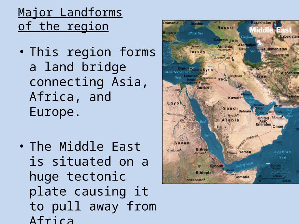
Major Landforms of the region
• This region forms a land bridge connecting Asia, Africa, and Europe.
• The Middle East is situated on a huge tectonic plate causing it to pull away from Africa

• Occupied by Turkey, the Anatolian Peninsula marks the beginning of the Asian continent
Not occupied by a bunch of these… …The
country of Turkey!!!

Arabian Peninsula
Most distinctive landform is the Arabian Peninsula.

• Much of the Arabian Peninsula is covered by barren plains.
• For centuries, people living on the Arabian Peninsula had to adapt to the harsh conditions by living nomadic lives in search of water
“Even I’m thirsty.”

• The heart of Iran is a plateau bordered by the Zagros Mountains.

Climate of the Middle East• Extremely arid (desert)
• Most areas receive less than 18 inches of rain a year!
• Mediterranean climate (along the coasts) are in other parts of the region making the land green and lush for parts of the year.

Rub al-Khali:“The Empty Quarter”
The most famous desert…
AKA…the place where no one comes out.
* The size of Texas on the Arabian Peninsula

Which country is completely land-locked?
What issues might this cause?

• How can mountains and deserts be useful to people???– A natural barrier to protect from foreign invaders
This is tough…
I’m thirsty.

Tigris River in Southeastern Turkey

• Canal = man-made waterway connecting 2 bodies of water
• Strait= naturally occurring waterway connecting 2 bodies of water

Suez Canal• Links Mediterranean Sea to the Red Sea
• Completed by the British in 1869

What is unique about this waterway?
Strait of Hormuz
I’ll give you a hint…
There is an abundance of a certain natural resource located right here

Water in the Middle East
• Almost completely surrounded by water but because much of the region is arid, there are few rivers that flow the entire year.

The Tigris & Euphrates
River System
Mesopotamia: ”Land Between the
Two Rivers”aka the Fertile
Crescent
Mesopotamia: ”Land Between the
Two Rivers”aka the Fertile
Crescent
• The two most important rivers• Flow parallel• Land is very fertile between them

Tigris and Euphrates• Flow through parts of Turkey, Syria, and Iraq• Makes land very fertile and good for
agriculture.
• Flow almost parallel for hundreds of miles before joining at a place called Shat al Arab.

Jordan River
• Empties into the Dead Sea
• Natural boundary between Jordan and Israel

Dead Sea: Lowest Point on Earth
- HighestSalt
Content(33%)
*9x saltier than
ocean
- HighestSalt
Content(33%)
*9x saltier than
ocean

Irrigation Systems
• Water is the most precious resource so water usage is one of the many international conflicts in the region.
• Irrigation/dam systems are controversial because countries downstream will lose use of the water for irrigation and hydroelectric power.

Oil• Oil fields in Middle
East hold ½ of all petroleum reserves in the world!
• Oil is transported mostly by carefully monitored above and underground pipelines


![Chronology of the coinage of Antiochus VIII of Syria / [C. Oman]](https://static.documents.pub/doc/80x56/577cbc8b1a28aba7118da872/chronology-of-the-coinage-of-antiochus-viii-of-syria-c-oman.jpg)


