A G OF THE HUDSON VALLEY DURING THE AMERICAN WAR OF INDEPENDENCE The Military Geography of Fortress West Point EOGRAPHICAL PERSPECTIVE OF THE ROLE OF WEST POINT IN THE DEFENSE ËËËËË By Lieutenant Colonel F ancis A. Galgano Jr. Department o Engineering Uni my West Point, New York [ \ Association of American Geographers New York, New York Colonel Eugene J. Palka & r f Geography and Environmental ted States Military Acade Field Trip Guidebook Annual Meeting
Transcript
A G OF
THE HUDSON VALLEY DURING THE AMERICAN WAR OF INDEPENDENCE
The Military Geography of Fortress West Point
EOGRAPHICAL PERSPECTIVE OF THE ROLE OF WEST POINT IN THE DEFENSE
By
Lieutenant Colonel F ancis A. Galgano Jr.
Department o Engineering Uni my
West Point, New York
Association of American Geographers
New York, New York
Colonel Eugene J. Palka &
r
f Geography and Environmentalted States Military Acade
Field Trip Guidebook
Annual Meeting
-2
27 February 2001
The Military Geography of Fortress West Point
A GEOGRAPHICAL PERSPECTIVE OF THE ROLE OF WEST POINT IN THE DEFENSE OF THE HUDSON VALLEY DURING THE AMERICAN WAR OF
INDEPENDENCE
By
Colonel Eugene J. Palka and Lieutenant Colonel Francis A. Galgano Jr.
Table of Contents Part I
THE REVOLUTIONARY WAR LANDSCAPE OF THE LOWER HUDSON
VALLEY: A MILITARY GEOGRAPHIC ANALYSIS. 1 Part II
A STRATEGIC POINT ON THE HUDSON RIVER. 15 Part III
THE FORTIFICATION OF WEST POINT: A CHRONOLOGY 27 Part IV
VIEW DESCRIPTIONS 45
ACKNOWLEDGMENTS 48 Cover art provided by Mr. Robert Getz
-1
PART I THE REVOLUTIONARY WAR LANDSCAPE OF THE LOWER
HUDSON VALLEY:
A MILITARY GEOGRAPHIC ANALYSIS
by
Colonel Eugene J. Palka, Ph.D.
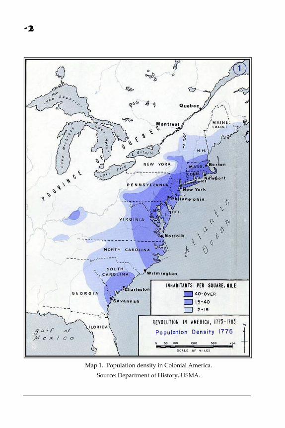
Intro - ductionrior to the Revolutionary War, the Thirteen Colonies stretched nearly 1,200 miles along the Atlantic coast, with approximately 2.5 million people settled in a long sweeping arc from Boston in the north to
Savannah in the south (see map 1). Slightly less than half of the people were clustered in New England towns, while the remainder lived on dispersed farmsteads and plantations or in small villages throughout the Middle and Southern Colonies. All of the prominent cities were on the coast or along navigable waterways.
P The Hudson River and Chesapeake Bay, with its main tributary, the Susquehanna River, formed natural divides, separating the inhabited portions of the
-2
Map 1. Population density in Colonial America.
Source: Department of History, USMA.
-3
colonies into three regions. The regions differed in terms of climate, soil, and natural resources. As populations increased, regional settlement patterns, and unique economic and political systems provided early evidence of distinct cultural geographic regions. Eventually three culture hearths emerged: New England, Middle Atlantic, and Tidewater‐Virginia. The principal water routes that penetrated deeply into the interior shaped these sub‐regions of Colonial America, influenced settlement patterns, and provided the mediums for spatial interaction.
Patterns of regional complementarity emerged by the mid‐eighteenth century. Subsistence farming was widespread throughout the Colonies and areas that produced grain and cattle for interregional markets were generally divided by the Hudson River. The Middle and Southern Colonies were the leading producers of grain, while large numbers of livestock were reared on Connecticut farms and were driven to markets elsewhere. Small mills and factories in New England provided the Continental Army with clothing and military equipment and through its ports passed munitions and armaments from France, destined for the American Army west of the Hudson. Conversely, New England received substantial food supplies from the more productive agricultural lands in the Middle Colonies (Palmer, 1969).
The Hudson River was one of the central links to interregional commerce since it was navigable for large sailing vessels from New York harbor ‐ upriver to Albany. Long before the Revolution it had been a frequent invasion route between Canada and the Colonies for both French and British expeditions. Use of the waterway had opened settlement north of the Hudson Highlands, and by 1775, New Yorkʹs population within the Hudson River Valley was estimated at 185,000 (Thompson, 1966). The leading edge of settlement included a narrow corridor penetrating west into the fertile Mohawk and Cherry Valleys. The powerful and hostile Iroquois Nation, traditionally allied with the British, had been steadily forced westward by advancing settlers. Conflict between colonial frontiersmen and Native Americans was inevitable. American military action against the Indians and their British supporters was deemed necessary to gain and maintain control of the Hudson‐Mohawk river system and to protect settlers against sporadic Iroquois raids.
The Strategic Setting -
Prior to the Revolutionary War, navigable rivers served as the principal transportation networks on the North American continent (Brown, 1948). A few bridges spanned only the narrowest streams near the larger settlements. Ferries or fords were used exclusively to cross major rivers. Spatial interaction entailed slow overland movement, sailing from port to port along the eastern seaboard, or tedious movement inland via major river systems. In the latter case, a break‐in‐bulk point, smaller boats, and occasional portage were involved.
-4
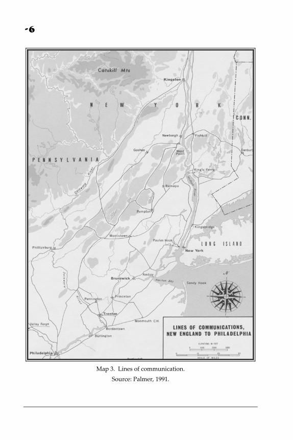
The significance of the Hudson River was apparent even before the Revolution, as it provided the only non‐oceanic avenue of approach for the French into the Colonies, or the British into Canada (Miller et al, 1988; Rutledge, 1956; Kagan, 1966) during the Colonial Wars. By the outset of the Revolutionary War, the Hudson River was perhaps the main inland thoroughfare within the colonies (see map 2). The river linked New York Harbor and Canada either via a route through Lake Champlain, or via the Mohawk River, Lake Oneida, Oswego River, and Lake Ontario. Ferry‐crossing sites along the Hudson also linked New England with the Middle Atlantic colonies. The main crossing points between New York City and Albany were at Newburgh and at Verplanck’s Point. Kingʹs Ferry (between Verplanckʹs Point and Stony Point) linked a trunk road from Massachusetts and Connecticut to one extending southwest into New Jersey and Pennsylvania (Stowe, 1955). The Albany Post Road paralleled the Hudson River on the east, passing through Peekskill, Continental Village and Fishkill. As such, the river was vital to both north‐south and east‐west travel and communications (see map 3).
During the Revolutionary War, American and British commanders alike recognized the strategic importance of the Hudson River as a major thoroughfare into the interior of the colonies and as a vital link between New England and the Middle‐Atlantic. A concerted effort was made by the Continental Army to construct and fortify positions along the lower Hudson in order to protect crossing sites, ensure the continued flow of logistics and commerce, and prevent the British from using the river as a major thoroughfare to transport troops and supplies.
The British Perspective -
The British sought to control the Hudson River for both strategic and practical reasons. First, by seizing control of the Hudson, the British could literally divide the Colonies in half and isolate the rebellion in New England. Second, the Hudson was the most efficient link necessary to reinforce their Indian allies in upstate New York. The Saint Lawrence Seaway provided and alternative route, however, the latter required several portages and was rendered unusable by ice during much of the winter. Third, by controlling the Hudson, the British could deny agricultural supplies from the interior of New York, commercial trading between the New England and Middle Atlantic Colonies, and logistics reinforcements to the Continental Army.
The Patriot Perspective -
In one respect, the Patriot effort to control the Hudson was intended to deny British use of the river to accomplish tactical and strategic objectives. The river was a vital transportation corridor that constituted ʺdecisive terrainʺ for both the British and
-5
Map 2. The strategic setting.
Source: Dunwell, 1991.
the Colonists. The following issues, however, were chief concerns of the Continental Army. First, the Hudson River was the crucial link for providing logistical support to the continental Army in the field. Second, it was necessary to maintain the flow of commerce throughout the Colonies, where patterns of regional complementarity had already developed. Third, the Patriots wanted to cut the supply lines between the British and their Indian allies in the interior. Fourth, it was important for the Continental Army to maintain the flexibility to maneuver. It was imperative to preserve the capability of either massing or economizing their force as necessary in response to British attacks throughout New England and the Middle Atlantic, while avoiding the prospect of being cut‐off and/or divided from other American forces. Finally, Patriot control of the Hudson required the British to garrison troops in Canada in order to deter a Continental invasion (Miller et al, 1988).
-6
Map 3. Lines of communication.
Source: Palmer, 1991.
-7
Military Geographic Analysis -
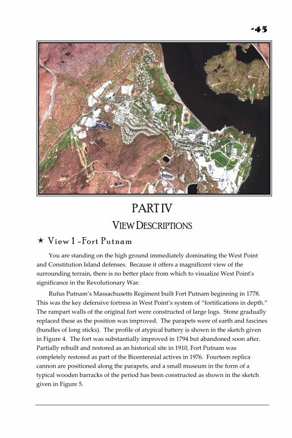
Given the strategic significance of the Hudson to both the British and the Patriots, it was necessary for the latter to assess the physical characteristics of the river, as well as the adjacent terrain, in order to develop an effective defensive scheme. The Hudson is tidal from its mouth into the Atlantic Ocean south of New York City, upriver to Albany. Consequently, sailing ships were affected by tides, current, and winds. From a defenderʹs perspective, ideal locations included those locales where the river was narrow, ebb tide was at its strongest, wind was unpredictable and treacherous, and where adjacent terrain had a commanding view of the river and could be easily fortified (Miller et al, 1988). This military geographic analysis directed the Continental Army towards three specific locations: Dunderberg, Anthonyʹs Nose, and Martelaer’s Rock (see map 4).
In addition to securing defensive positions to attack British vessels sailing up the Hudson, it was also necessary for the Patriots to protect East‐West lines of communications. As such, river‐crossing sites constituted key terrain and required protection. Most important were the ferry crossings between Stony Point and Verplanck’s Point in the south (known as Kings Ferry), and between Fishkill Landing and Newburgh in the north. The above analysis explains the eventual construction of fortifications at Stony Point, Peekskill, Fort Clinton, Fort Montgomery, Fort Constitution, West Point, and Plum Point.
The Makings of a Military Geographical Imprint -
With the idea of focusing the initial effort on the treacherous part of the river known as “World’s End,” work to fortify Martelaerʹs Rock (later named Fort Constitution) began in August 1775, and the island was formally garrisoned on September 21, 1775 (Adams, 1996b). In June 1776, Continental soldiers began construction of Forts Montgomery and Clinton (Dunwell, 1991). In August of that same summer, efforts to erect Fort Independence were also undertaken (Dunwell, 1991). Additionally, between 1775 and 1777, twenty‐seven redoubts were established and occupied throughout the Highlands (Dunwell, 1991). Redoubts were small fortifications that were located on principal mountaintops throughout the region. Each functioned as an observation point manned by a group of five to seven Continental soldiers, and in some cases, the redoubts protected key terrain features such as a mountain pass (USMA, Department of History, 1998). In an effort to protect the Kings Ferry, Stony Point was fortified on the west bank of the Hudson while Fort Lafayette was constructed on the east bank at Verplank’s Point.
-8
Map 4. Key terrain and fortifications along the Hudson River.
Source: Dunwell, 1991.
-9
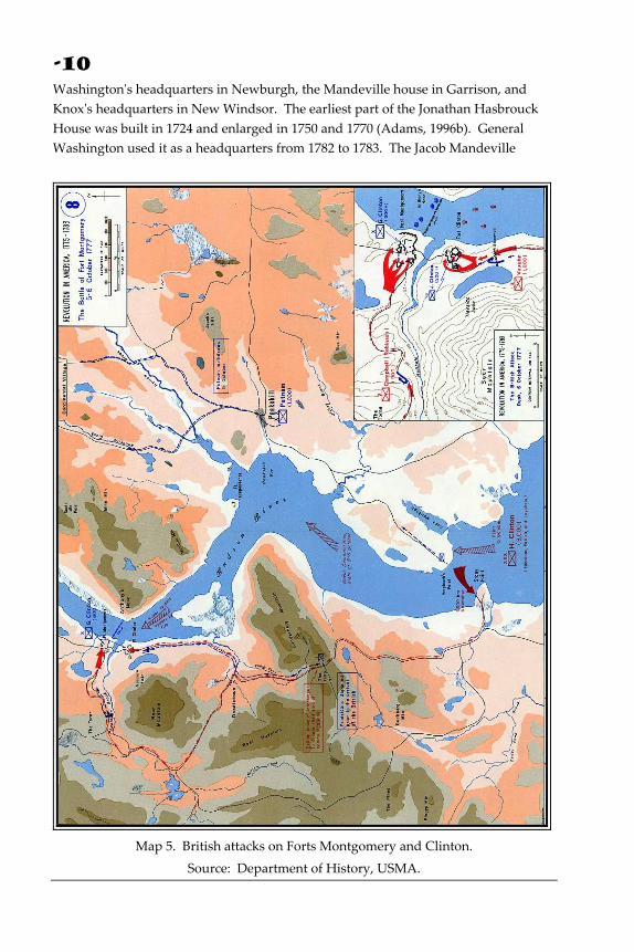
On October 6, 1777, British forces under the command of Sir Henry Clinton seized Forts Montgomery and Clinton, and Constitution Island (USMA, G&CS, 1983). After brief occupations, the forts were destroyed and the British forces withdrew (see map 5). In the aftermath, General Washington recommended the fortification and defense of West Point, and so the latter was occupied in January 1778. Preparations commenced three months later on the construction of Fort Putnam on the dominant piece of terrain overlooking West Point, Constitution Island, and the Hudson River. Additionally, several mutually supporting redoubts were emplaced and in the spring of 1778, Colonel Thaddeus Kosciusko directed the construction of Fort Arnold on the level of the present‐day parade ground (Adams, 1996b; see map 6). The fort was later renamed Fort Clinton after Benedict Arnold’s defection in 1780 (G&CS, 1983). ʺFortress West Pointʺ was never attacked, but on June 1, 1779, the British captured Forts Lafayette and Stony Point (Adams, 1996). The latter was retaken by General ʺMad Anthonyʺ Wayne and about two thousand Continental soldiers during a daring night attack on July 16, 1779. After winning the battle decisively, Wayne evacuated the fort three days later (see map 7).
The Cultural Material Residual -
More than 225 years later, the cultural landscape of the region still bears proof of earlier military geographic analyses by commanders and politicians as they sought to gain and maintain control of the river. Toponyms, fortifications, obstacles, and battlefields continue to endure as recognizable, if not distinctive, imprints on the cultural landscape of the lower Hudson Valley. These features contribute to the spirit of the region and remind us of its strategic importance during the American Revolution.
Among the remnants of the Revolutionary War landscape, West Point and its environs are perhaps the most distinctive and most celebrated. The United States flag has been flown at West Point since 1778, and the post has housed the US Military Academy since 1802. On the Academy grounds, Fort Putnam has been well preserved, as have numerous redoubts and fortifications on Constitution Island, and parts of the original Fort Arnold. Stony Point battlefield, located to the south of West Point, is also well preserved and continues to be a tourist attraction. During peace negotiations in 1782, General Washington ordered the encampment of American troops in New Windsor. The last encampment of the Continental Army has been preserved and partially restored, and includes the Public Building or Temple of Virtue, a spacious hall erected for religious services and other large assemblies, and one other surviving wooden structure built by Revolutionary soldiers, an Officersʹ hut.
Examples of individual built structures of historical significance include
-10
Washingtonʹs headquarters in Newburgh, the Mandeville house in Garrison, and Knoxʹs headquarters in New Windsor. The earliest part of the Jonathan Hasbrouck House was built in 1724 and enlarged in 1750 and 1770 (Adams, 1996b). General Washington used it as a headquarters from 1782 to 1783. The Jacob Mandeville
Map 5. British attacks on Forts Montgomery and Clinton.
Source: Department of History, USMA.
-11
House was built in 1737 and is perhaps the oldest major building in the Garrison area. The house served as officersʹ quarters from 1778 to 1783. Major General Henry Knox, Washingtonʹs commander‐in‐Chief of Artillery, established his headquarters in New Windsor in a house built in 1754 by Colonel Thomas Ellison (Eberlein and Hubbard, 1990). During the war, General Knox and General Nathaniel Greene, the Quartermaster of the Army, occupied rooms in this historic stone house. Each of these structures was important not because of its form, but because of its function. The specific location of each was of course dictated by security, accessibility, and the feasibility of providing command and control of the Continental forces throughout the Hudson Valley.
Map 6. The defensive plan for the West Point.
Source: Department of History, USMA.
-12
Map 7. The battle for Stony Point.
Source: Department of History, USMA.
Conclusion - The Hudson Valley provided the context for a pivotal era in American history. During the course of the Revolutionary War, the pristine, scenic valley experienced a concerted effort by the Colonial Government and Continental Army to reinforce the
-13
natural terrain in an attempt to deny the British use of the Hudson River, while maintaining the strategic thoroughfare to suit their own needs. The cultural material residual on the landscape and the numerous toponyms on current local maps reveal a distinct and enduring imprint that was superimposed on the region more than 225 years ago. Some of the features are only subtle reminders. Others are more obvious, and as either tourist attractions or relict structures, they provide clear evidence of the attempts to shape the landscape for defensive purposes during the struggle for independence. As such, they collectively recall the significance of the region during a celebrated part of American history.
The historian, Sidney Fisher, in his study of the Revolutionary War, concluded that, ʺWest Point and the Highland Passes constituted the most important American strategic positions. If Benedict Arnoldʹs treachery had succeeded in delivering West Point to the British, the war might have ended sooner and otherwise.ʺ (Fisher, in Steele, 1951, p. 14).
Bibliography -
Adams, Arthur G. 1996a. The Hudson Throughout the Years. New York: Fordham University Press.
_____. 1996b. The Hudson River Guidebook. New York: Fordham University Press.
Brown, R. H. 1948. Historical Geography of the United States. New York: Harcourt Brace and World, Inc.
Diamant, Lincoln. 1994. Chaining the Hudson. New York: Carol Publishing Group.
Dunwell, Frances F. 1991. The Hudson River Highlands. New York: Columbia University Press.
Eberlein, Harold Donaldson and Hubbard, Cortlandt Van Dyke. 1990. Historic Houses of the Hudson Valley. New York: Dover Publications, Inc.
Fite, G.C., and Reese, J.E. 1965. An Economic History of the United States. New York: Houghton Mifflin Company.
Kagan, Hilde Heum, ed. 1966. The American Heritage Pictorial Atlas of United States History. New York: American Heritage Publishing Company.
Kick, Peter; McMartin, Barbara; and Long, James M. 1994. 50 Hikes in the Hudson Valley, 2nd edition. Woodstock, VT: Backcountry Publications.
-14
Miller, LTC Charles E., Jr. 1972. The Fortification of Constitution Island 1775‐1783. West Point, NY: Department of History.
Miller, Charles E., Jr., Lockey, Donald V., and Visconti, Joseph, Jr. 1988. Highland Fortress: The Fortification of West Point During the American Revolution, 1775‐1783. West Point, NY: Department of History.
Palmer, Dave Richard. 1969. The River and the Rock: The History of Fortress West Point, 1775‐1783. New York: Greenwood Publishing Corporation.
_____. 1991. The River and the Rock, 2nd ed. West Point, NY: Association of Graduates with Hippocrene Books.
Rutledge, Joseph Lister. 1956. Century of Conflict: The Struggle Between the French and British in Colonial America. Garden City, NY: Doubleday Books.
Stowe, G.C., and Weller, J. 1955. Revolutionary West Point: The Key to the Continent. Military Affairs, 19: 81‐92.
Thompson, J.H., ed. 1966. Geography of New York State. Syracuse: Syracuse University Press.
USMA, Department of Geography & Computer Science. 1983. Guidebook to the Historical Geography of Fortress West Point. West Point, NY: United States Military Academy Press.
USMA, Department of History. 1998. West Point Fortifications Staff Ride. West Point, NY.
-15
PART II
A STRATEGIC POINT ON THE HUDSON RIVER 1
Edited by
Lieutenant Colonel Francis A. Galgano Jr., Ph.D.
efore the Revolution, West Point was not a significant place. The first known use of the term ʺWest Pointʺ was entered in correspondence on August 6, 1757, in the diary of Goldsbrow Banyar, deputy secretary of the
Province of New York, who recorded, ʺAt 7 this Evening came to an Anchor at the W. Point of Marblingʹs Rock [Martelaerʹs Rock],” (M.A.H., I, p. 17). In deeds, land papers and military records of the Revolutionary period, the form used was always ʺthe West Point,ʺ the definite article being retained, because the point of reference was from the older, better‐known and more populous locations on the eastern bank of the Hudson River. Usage fixed the name as West Point (Berard, 1886).
B
1 Adapted from “Guidebook to the Historical Geography of Fortress West Point,” Department of Geography and Computer Science, USMA, West Point, New York, 1983
-16
Settlement in the area was established largely to fulfill the terms of the land grants. West Point proper was ceded to Captain John Evans on March 1, 1694, as part of a larger grant. Finding it difficult to make a living there, he soon vacated and the property reverted to the Crown. The northern portion, an area embracing 1,463 acres, was granted to Charles Congreve by royal letters patent on May 17, 1723. Another section of the Evans grant touching the southwest corner of the Congreve patent, encompassing 332 acres, was patented to one John Moore, on March 25, 1747. In later years Moore bought the Congreve patent and conveyed it by will, together with his own holdings, to his son Stephen Moore, a North Carolina merchant (Knowlton, 1839).
The lack of level, arable land limited settlement on these tracts, although some wealthy recipients of large grants built ostentatious mansions before the military occupation of West Point (see map 8). There was the Moore House (Red House), because of its pretentious construction sometimes referred to as ʺMooreʹs Folly,ʺ at which Washington and other general officers later established their headquarters. The Beverly Robinson House at which General Benedict Arnold established his headquarters was on the east bank of the river, opposite Buttermilk Falls, a frothing mountain stream two miles south of West Point. A short distance to the north of Robinsonʹs House stood another mansion, frequently mentioned in the records as Mandevilleʹs. Each of these estates contained a few cultivated fields and tenant farm dwellings. Nearly all of these old houses have since disappeared. Most of the traces of manʹs occupation on West Point date from the Revolutionary period. They consist of remnants of forts and storehouses, military roads, fireplaces, buttons, flints from gunlocks, broken trunnions, clay pipes, hand‐wrought nails, combs, and bricks.
The geological formation of the Hudson Highlands lent logic to their fortification. The geologic structure of the West Point region is part of the belt of granite and complex gneiss mountains stretching northeast from Pennsylvania, across northern New Jersey and southeastern New York, into western New England (Berkey, 1919; Miller, 1924). In crossing the Hudson Valley, these hills form a barrier of highlands about fifteen miles wide. A characteristic feature of the riverʹs effect on this geologic structure is the deep river gorge, the independent mountain masses on both sides of the river, and small rocky islands, some of which are connected with the mainland. Additionally, the highlands include characteristic fluvial and glacial terraces, about one hundred fifty feet above sea level, one of which is the West Point Plain, and three remarkably sharp turns or angles in the river⎯at West Point, Anthonyʹs Nose, and Dunderberg⎯where the hard crystalline rock has withstood the erosive power of the water (see map 9). At West Point the river channel was narrowed even more by the rocky island (Martelaerʹs Rock), now Constitution Island, directly east of West Point.
-17
Map 8. The fortifications at West Point and Constitution Island
Source: Department of History, USMA.
The critical phase of the Revolution was the contest for control of the Hudson and West Point played a central role in this struggle. Command of these hills meant control of traffic on the river. West Point is clearly the most dominating river position in the Highlands because of the structure of the terrain and it forms the sharpest angle on the river. Here the Hudson, which normally flows in a north and south direction, turns abruptly west and then back again to the north (see map 8). In the days of sail, boats were vulnerable to shore batteries when forced to slow down to navigate this turn (Nickerson, 1928). Furthermore, sailing around the bend at West Point is problematic because of tricky winds and the ebb and flood tide currents.
Early on, George Washington urged the fortification of the Highlands. As a representative to the Continental Congress from Virginia, he served with the congressional committee, which drew up and introduced the proposal on May 25, 1775, to erect batteries to prevent enemy vessels from using the river (J.C.C., II, 1904‐22). However, the British were planning similar measures (Force, III, 1837‐53).
-18
Map 9. The Hudson River channel in the Highlands.
Source: Department of History, USMA.
The New York Provincial Congress was directly responsible for this vital area and kept well informed of British plans. They quickly discerned British plans to seize and hold the Highlands (Force, III, 1837‐53). The Congress quickly ordered a survey of points along the Hudson most suitable for defense, and trustworthy persons like
-19
Colonel James Clinton and Christopher Tappan were appointed to the committee delegated May 30, 1775, to prepare preliminary plans (J.P.C.N.Y., 1775). The committee studied the terrain and decided upon the erection of the works on Martelaerʹs Rock (i.e., Constitution Island) and the North and South Redoubts on Fort Hill across the river from West Point (see map 8). They also recommended the construction of several batteries and Forts Montgomery and Clinton⎯to the north and south of Popolopenʹs Creek⎯six miles south of West Point. The committee urged, ʺthat ...by means of four or five Booms, chained together on one side of the river, ready to be drawn across, the passage can be closed up to prevent any vessels passing or repassing.ʺ (J.P.C.N.Y., 1775). For some reason they completely overlooked the commanding position of West Point. Congress accepted their proposals and ordered the necessary work done under the direction of several commissioners and an engineer, Bernard Romans.
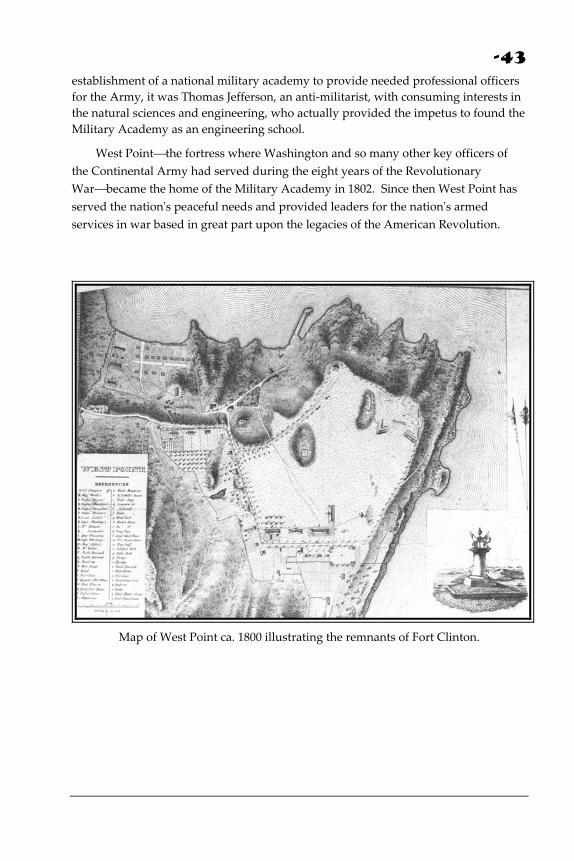
Figure 1. Color‐infrared aerial photograph of West Point and Constitution Island. The white dashed line illustrates the path of a British ship and the yellow arrows indicate the sight lines from batteries emplaced on the island. It would appear that the ship would have a difficult time negotiating the bend, fighting the river current,
the wind and the Colonial fortifications. This was the seminal flaw in the American effort to fortify and defend the Hudson Highlands for the next several years⎯a flaw that was nearly fatal to the Patriot cause. From the river perspective, and even in modern imagery (see Figure 1), it is easy to see how one could be attracted to viewing Constitution Island as the key
-20
terrain in the river bend at West Point. The position of Constitution Island is illustrated in Figure 1. At first glance it would appear that batteries established on Constitution Island would clearly dominate naval craft advancing from the south. However, the positions on Constitution Island are dominated by the terrain on either bank of the river, but by West Point in particular. Furthermore, batteries positioned on Constitution Island lacked the elevation to deliver plunging‐fire onto the relatively thin decks of an advancing man‐o‐war. This is illustrated in Map 10.
D
B
A
C
Map 10. Contour map of the West Point‐Constitution Island area. Spot elevations on the map illustrate the dominating terrain on either side of the island.
Batteries positioned at point C on Map 10 can easily be dominated by those placed at points A, B, or any location on the eastern bank of the river. This tactical disadvantage is illustrated in the line‐of‐sight diagram given in Figure 2. Positions on Constitution Island cannot deliver plunging fire to the decks of advancing ships, but as Figure 2 clearly illustrates, fortifications on Constitution Island are subject devastating plunging fire from batteries emplaced on either bank of the river, but especially from West Point (Point B, Figure 2). Furthermore, positions on West Point can easily deliver plunging fire against a passing naval vessel.
-21
A West Point
B Constitution IslandD
C
Marsh River
Figure 2. Line‐of‐sight diagram drawn along the line between Points A and D on Map 10. Constitution Island is located at Point C and is clearly at a tactical
disadvantage given its location and elevation.
Nevertheless, from the very beginning of their efforts, the Patriots were drawn to Constitution Island and Colonel Romans, a Dutch civil engineer, cartographer and naturalist planned and directed the construction of the first fortifications in the area. He was hardly trained to establish these important fortifications; however, he could boast that the British had previously employed him in various technical capacities, at the time he was the only person available with any aptitude to oversee the fortification of the Highlands. The work party under his direction arrived at Martelaerʹs Rock and preliminary construction began on August 29, 1775. Official reports from the island later that year were headed ʺFort Constitutionʺ (J.P.C.N.Y., 1775).
On Constitution Island a sharp difference of opinion arose between Colonel Romans and the commissioners over the division of authority (Force, III, 1837‐53). The dispute contributed to doubts as to the usefulness of the works there, and forced the Provincial Congress again to investigate the Highlandsʹ fortifications. The findings, reported on November 23, 1775, contain the first official suggestion recommending the occupation and garrisoning of West Point:
The fortress [on Constitution Island] is unfortunately commanded by all the grounds about it; but the most obvious defect is that the grounds on the West Point are higher than the Fortress, behind which an enemy may land without the least danger. In order to render the position impassible, it seems necessary that this place should be occupied, and batteries thrown up on the shore opposite.
(Force, III, 1837‐53)
-22
The disagreement with Colonel Romans exposed a problem, which plagued both the Provincial and the Continental Congress during the entire course of the war: the difficulty of obtaining qualified engineers to oversee the construction of important fortifications. Captain William Smith superseded Bernard Romans in January of 1776; he in turn was quickly replaced, and there followed a succession of officers. During that same year, as soon as spring weather made it possible, Colonel George Clinton, Revolutionary governor of New York, cooperated with his brother, Colonel James Clinton, in the erection of Forts Clinton and Montgomery.
In the fall of 1777 General Sir Henry Clinton, the British commander, organized an expedition for the capture of the forts in the Highlands. Early in October, the British landed at Verplanckʹs Point and drove the garrison out, then crossed over to Stony Point, moved north, and took Forts Montgomery and Clinton. On October 8, two thousand men under General William Tryon proceeded up the Hudson River to Constitution Island to complete the demolition of the Highlandsʹ fortifications (Heath, 1798). But the British victory was short‐lived, for the capture of General Burgoyne and the British Army at Saratoga forced Sir Henry Clinton to abandon the Highlands after twenty days occupation and return to his base in New York City. However, his temporary success thrust ʺthe West Pointʺ into a position of prominence, and crystallized American opinion on the advantages of that location for a fort. General Washington, in a letter to Major General Israel Putnam dated December 2, 1777, discussing the construction of new works on the river, especially recommended that a, ʺstrong fortress should be erected at West Point, opposite to Fort Constitution.” (Fitzpatrick, X, 1931‐44)
The first group to occupy West Point was a section of a Massachusetts brigade under the command of General Samuel Holden Parsons. The unit crossed the river on the ice on January 20, 1778, and climbed the hill. An officer of Parsonʹs Brigade recorded the first occupation of West Point:
Coming on to the small plain surrounded by very high mountains, we found it covered with a growth of yellow pines 10 or 15 feet high; no house or improvement on it; the snow waist high. We fell to lopping down the tops of the shrub pines and treading down the snow, spread our blankets, and lodged in that condition the first and second nights. Had we not been hardened by two years of previous service we should have thought it difficult to endure this. The pines not being large enough for logs for huts, we were under the necessity of making temporary covers of these scanty materials until we could draw logs from the edge of the mountain and procure the luxury of log huts; this we effected but slowly, the winter continuing severe. In two or three weeks we had erected our huts, and a French engineer by the name of La Radiere arriving, the snow
-23
being removed for the site of the present main fort, the works were traced out, and parties sent out every fair day up the river to cut timber and drag it on to the ice, to be ready to float it down to the Point when the river should be clear of ice. This service was rather fatiguing to the men, but as they had a cabin to lodge in at night and provisions served out with tolerable regularity, they thought themselves comparatively happy, though their work was incessant (Richards, IV).
The winters were brutally cold for the men, yet they thronged in companies, regiments, and brigades from every part of New England, from every province in the South, and worked winter and summer, and the fortifications were pushed forward.
Meanwhile, Captain Thomas Machin, an experienced artillery officer, had charge of laying the chain and boom across the Hudson (see maps 8 and 11). The links were forged in the winter of 1778 at the Sterling Iron Works, in the mountains about twenty‐five miles from West Point. Hammers and anvils worked day and night for six weeks. The chain, which weighed 140 to 150 tons, was mounted on logs, and each spring, until the end of the war, it was stretched across the Hudson and taken up before the river froze. Links of the chain with a swivel and clevis may still be seen displayed at Trophy Point on the edge of the Plain at West Point.
Figure 3. The Great Chain between West Point and Constitution Island.
Source: Palmer, 1969.
-24
Lieutenant Colonel Louis Dashaix de la Radiere, first assigned to oversee the construction of the principle fortifications on West Point, found it impossible to complete this work. He was succeeded in the spring of 1778 by Thaddeus Kosciuszko who spent over twenty‐eight months, almost without interruption, at West Point (Haiman, 1943).
The main fortification was at the edge of the Plain (see maps 10 and 11). By the summer of 1778, this work was sufficiently advanced toward completion to receive the name Fort Arnold to honor Benedict Arnold, the hero of Quebec. Renamed Fort Clinton upon Arnoldʹs defection, it consisted of huge tree trunks piled on a wall of steep rock and hand‐hewn stones. Fort Clinton was supported by Colonel Henry Sherburneʹs redoubt also on the level of the Plain. Above Fort Clinton, on the high ground to the west stood Fort Putnam, whose ramparts enclosed a powder magazine, cistern, and garrison quarters. These were completed during the summer of 1779. Below Fort Putnam, covering the southern approaches, were built Forts Wyllis, Webb and Meigs, named after their respective commanders: Colonel Samuel Wyllis, Colonel Charles Webb, and Colonel Return J. Meigs. High in the hills were four strong redoubts with connecting trails, and along the riverbank were several shore batteries (see map 8).
The last successful British effort to invade the Highlands took place at the end of May 1779, when they again seized Verplanckʹs and Stony Point. Shortly thereafter, on July 25, 1779, Brigadier General Anthony Wayne, in a daring move, recaptured Stony Point with the whole enemy garrison, its cannon and stores. Washington, who lauded Wayneʹs success and looked upon West Point as ʺthe most important Post in Americaʺ (Fitzpatrick, XXI, 1931‐44), then transferred his headquarters to West Point to conduct the defense. He remained there from July 25 to November 28, 1779.
Shortly after Washington moved his headquarters from West Point in 1779, he directed Generals McDougall and Steuben to reinforce the garrison and cover the southern entrance to the Highlands. On August 3, 1780, Major General Benedict Arnold was instructed to proceed to West Point and to relieve General Robert Howe of the command. Arnold arrived at the Robinson House on August 5 and established his headquarters there. It was from this point that he conducted his negotiations with Major John André to sell West Point to the enemy (Van Doren, 1941). The enormity of his crime can be understood only by comprehension of the value of West Point to the Patriot cause, of the amount of blood and treasure sacrificed to construct the fortifications, and of the energy expended to defend this strategic heart of the United States. At the close of the Revolution, the fortifications remained and their historic walls, partially restored for preservation, may still be seen in the Highlands of the Hudson, concentrated in the area of West Point.
-25
Map 11. The 1780 Villefranche plan of West Point.
Source: Palmer, 1969.
Bibliography - Berard, A.B. 1886. Reminiscences of West Point in the Olden Time, East Saginaw,
Michigan.
Berkey, C.B., and Rice, M. 1919. Geology of the West Point Quadrangle, N.Y. New York State Museum Bull. 225, 226.
-26
Boynton, E.C. 1863. History of West Point and its Military Importance during the American Revolution, New York: D. Van Nostrand.
Brown, R.H. 1948. Historical Geography of the United States, New York: Harcourt Brace and World, Inc.
Clermont‐Crèvecoeur. 1781. Descriptions of the Stronghold of West Point. Printed extract in USMA Library Archives, West Point.
Duportail, L. 1779. Study for the Defense of West Point. Typewriter translation from the French in USMA Library Archives, West Point.
Fite, G.C., and Reese, J.E. 1965. An Economic History of the United States, New York: Houghton Mifflin Company.
Fitzpatrick, J.C., ed. 1931‐1944. The Writings of George Washington, vols. 10, 16, 21. Washington, D.C.
Forman, S. 1950. West Point: A History of the United States Military Academy, New York: Columbia University Press.
Heath, W. 1798. Memoirs of Major General Heath. Boston.
Journals of the Continental Congress, 1774‐1789, 1904‐1922, 2:60.
Journal of the Provincial Congress of New York, May 25, 1775 to June 13, 1776.
Knowlton, M. 1839. Lands Belonging to the United States at West Point. West Point.
Magazine of American History. 1877‐1893. 1:17.
Miller, W.J. 1924. The Geological History of New York State. New York State Museum Bull. 255.
Nickerson, H. 1928. The Turning Point of the Revolution. Boston.
Palmer, D.W. 1969. The River and the Rock: The History of Fortress West Point, 1775‐1783, New York: Greenwood Publishing Corporation.
Richards, S. 1903. Personal Narrative of an Officer in the Revolutionary War. United States Magazine, 3d ser., vol. 4.
Ruttenbur, E.M. 1860. Obstructions to the Navigation of the Hudsonʹs River, Albany.
Steele, M.F. 1951. American Campaigns, Washington, D.C.: Combat Forces Press.
Stowe, G.C., and Weller, J. 1955. Revolutionary West Point: The key to the continent. Military Affairs. 19: 81‐92.
Thompson, J.H., ed. 1966. Geography of New York State, Syracuse University Press.
Van Doren, C. 1941. Secret History of the American Revolution. New York.
-27
PART III
THE FORTIFICATION OF WEST POINT: A CHRONOLOGY2
Edited by Lieutenant Colonel Francis A. Galgano
n May 1775, as the Second Continental Congress was meeting in Philadelphia, word reached anxious members that Patriot militia under Ethan Allen and Benedict Arnold had seized Fort Ticonderoga, the
wilderness fortress which stood about 225 miles north of New York on Lake Champlain. Upon hearing this sobering news, American leaders realized that the colonies would have to face the imminent prospect of war with Great Britain.
I Almost immediately, the Congress appointed a committee to consider the defense of New York. Chaired by George Washington, the committee believed that the colonists would have to protect and secure the Hudson Highlands, which stretched, from the Tappan Zee to the river town of Newburgh.
From the experience of the French and Indian War, the American leaders knew that the natural invasion route into the colonies from Canada was Lake Champlain to 2 Adapted from West Point and the Hudson Highlands in the American Revolution, LTC J.H. Bradely, West Point, New York, 1976.
-28
the Hudson River, and that conversely, the same water corridor was the natural invasion route into Canada from the colonies. Furthermore, the Americans knew that the Highlands controlled the major northeast to southwest land routes of communications, which crossed the Hudson from Fishkill to Newburgh in the north and from Verplanckʹs Point to Stony Point (Kingʹs Ferry) in the south. If the British should cut these land routes, they might stop the Americans from moving supplies between New England and the Middle Atlantic colonies and also block the movement of military reinforcements between the colonies. Freedom of movement was particularly important because New England was to provide the bulk of the troops in the war. Loss of the Hudson Highlands, moreover, would isolate the American colonists in upper New York and would leave them at the mercy of the Indians whom the British could more adequately supply and who would become dangerous to the local settlers.
Washington and his committee quickly recommended that the Congress take steps to defend New York. Congress, in turn, sent resolutions to the New York Provincial Convention suggesting that:
. . . a post be taken in the Highlands, on each side of the Hudson River, and batteries be erected; and that experienced persons be immediately sent to examine said river, in order to discover where it will be most advisable and proper to obstruct the navigation.
ʹlʹhe New York leaders reacted promptly to the Congressʹ resolution and on the 2nd of June two members of the Convention, Colonel James Clinton and Mr. Christopher Tappen, sailed north to reconnoiter positions to be fortified in the Highlands.
As they sailed up the scenic river, Clinton and Tappen saw several possible sites for fortification in the rugged Highlands⎯Stony Point and Verplanckʹs Point, Anthonyʹs Nose, the banks of Popolopen Creek, Martelaerʹs Rock, and ʺthe West Point of the Hudson River.ʺ What the two men were looking for, however, was a place where both sides of the river could be fortified. The best choice appeared to be ʺthe West Point,ʺ where the river narrows into an S‐shaped bend between Martelaerʹs Rock and the west bank and is buffeted by unpredictable winds and subject to difficult tides. In addition to recommending the emplacement of batteries on ʺthe West Pointʺ and on Martelaerʹs Rock, Clinton and Tappen urged that a boom be constructed to block the channel to British ships. Surprisingly, they mistakenly recommended that the largest garrison in the area be established on the low ground at Martelaerʹs Rock, which West Point dominates.
Although the New York Provincial Convention accepted the recommendations of Clinton and Tappen and forwarded them to the Continental Congress, it did not order construction begun during the early summer. Only after Washington alarmed
-29
the New Yorkers with a report of a possible British raid on New York City, did the Convention act to fortify the Highlands.
1775 Constitution Island -
Late in August the New York Convention finally appointed a five‐man commission to supervise the fortification of the Hudson Highlands near West Point and Martelaerʹs Rock. Shortly thereafter, the commissioners engaged Bernard Romans, a Dutch botanist, to be their military engineer. Romans had few credentials to recommend him for military work. However, because there were so few engineers in America, the commissioners had little choice and counted themselves lucky to find anyone with a modicum of training or experience to construct the proposed fortifications.
When Romans arrived in the Highlands, he moved onto Martelaerʹs Rock and immediately reconnoitered the terrain looking for the best possible sites for gun batteries to cover the river. Concentrating on a grand bastion (named Fort Constitution after the British Constitution) on the southwest end of the island, Romans began to build a poorly sited fort, which failed to take best advantage of the range of his guns and the constricted Hudson River channel between the island and West Point. Moreover, Romans inexplicably ignored the recommendations of Tappen and Clinton to fortify the dominating heights of West Point across the river. If the Americans had been required to rely on Romansʹ position to stop the Royal Navy, a British captain of Nelsonian stripe probably would have been able to run the river gauntlet with ease.
When the commissioners discovered Romansʹ plans for siting the defensive works, they were furious. Unfortunately for the American cause, Romans and the commissioners then argued bitterly about the development of the islandʹs fortifications, delaying construction even further and endangering the security of the Hudson Highlands. When news of the argument reached the Continental Congress, it decided to arbitrate the dispute by appointing a committee to inspect the fortifications on the island. Arriving in November 1775, the Congressional commissioners did not like what they found. The works were so little advanced and so poorly sited that, in reality, Fort Constitution did not exist as a barrier to the Royal Navy. In addition, the Patriots had not blocked the landward approach from the east. Furthermore, like Clinton and Tappen before them, they saw the ground across the river at West Point dominated Romansʹ position. Before they left the island, the inspectors concluded that neither the New York commissioners nor Romans could handle the job of fortifying the Highlands.
The Congressional report naturally concerned the New York Provincial Assembly. Hence, they appointed their own committee to visit the island to smooth
-30
out the differences between Romans and the commissioners. Although the New York committeemen were likewise unable to improve conditions on the island, they did recommend that the Patriots fortify the ground near Popolopen Creek, about seven miles south of West Point, instead of Constitution Island. The idea of fortifying the area near Popolopen Creek was a good one, if not new. Romans and the commissioners, in one of their rare moments, had agreed that fortifications there would be better than on Constitution Island. Still, the New York inspectors ignored West Point.
As 1775 ended, the Patriots had not progressed very far with their fortifications on Constitution Island. In the next few weeks, the Continental Congress ordered the construction on the island stopped and then started again. To further disrupt efforts at fortifying the Highlands, Congress approved building the new fortifications near Popolopen Creek, a project that eventually brought the work on Constitution Island to a standstill.
Since only relatively simple field‐type works were required on Constitution Island, it is hard to believe that the Patriots accomplished so little in the fall of 1775. News from England indicated that they were going to have a stiff fight on their hands as soon as British reinforcements arrived. But even then the historic problems of raising a new army frustrated the colonials: an inadequate command system, lack of money, conflicting priorities, untrained leaders, inexperienced troops, lack of labor, graft, drunkenness, and just plain inefficiency. In 1775, the British could have taken the Highlands easily. In the spring of 1776, new efforts were directed at blocking the river at Popolopen Creek, south of Constitution Island. The Americans began to build Fort Montgomery⎯named for the American commander killed in the
preceding winter during the American invasion of Canada. Shortly thereafter, Washington heard about the poor condition of the fortifications in the Highlands. Gravely concerned, he assigned a new officer to command the area. Additionally he sent an inspection team under Brigadier General William Alexander Lord Stirling, to assess the situation for him. Lord Stirling and his assistants did a thorough job. They recommended that works be built at Stony Point and Verplanckʹs Point and that a new position be built on the south side of Popolopen Creek on the high ground which overlooked Fort Montgomery. At Constitution Island, Stirlingʹs party, like previous ones, saw that West Point dominated the island and recommended that a redoubt be placed on the west bank. Unfortunately, in his summarized report to Washington, Stirling did not mention West Point and the Patriots ignored this critical area again.
-31
1776: Twin Forts Of The Popolopen -
Just a few weeks later in July 1776, British warships ran past American positions on Manhattan and anchored in the Tappan Zee out of range of American land batteries. This threat triggered furious action in the Highlands and the Americans did everything possible to complete their forts on Popolopen Creek and to stretch a chain across the river between Fort Montgomery and Anthonyʹs Nose, on the east bank. Later, after the British defeated Washington on Long Island and at White Plains, the fortified positions in the Highlands assumed a critical importance to the American cause. However, Washington, after visiting the area in November, apparently thought that the Highland forts were strong enough to withstand a British advance and decided to move with his army toward New Jersey. While some American soldiers completed the two forts at Popolopen Creek, others constructed Fort Independence overlooking Peekskill Bay, just south of Anthonyʹs Nose. Simultaneously, engineers completed assembling an iron chain3 and moved it into place between Fort Montgomery and Anthonyʹs Nose. Because of design and structural weaknesses, the chain broke, and the Patriots could not block the river in 1776. Farther north, other soldiers attempted to block the river between Plum Point (near modern Cornwall) and Pollepel Island (now called Bannermanʹs Island) with underwater obstacles.
After facing several British threats in 1776, the soldiers in the Highlands settled down for the long, cold winter while Washington went south to fight his Christmas‐ New Yearʹs campaign at Princeton and Trenton and to winter at Morristown, New Jersey. Poised in a threatening position on the flank of the route between New York and Philadelphia, Washingtonʹs little army prevented Sir William Howe from moving between the cities and forced Howe to evacuate New Jersey. At the same time the Morristown camp and the Hudson defenses protected the only remaining land line of communications from Boston to Philadelphia, which ran down the valleys west of the Highlands. On the strength of those meager forces, buttressed by Patriot militia controlling the countryside, the Revolution survived its second winter.
1777 Defeat In The Highlands -
Beginning early in 1777, the situation in the Highlands changed radically. British commanders in London and America well knew the value of the Hudson River line and one of them, General John Burgoyne developed a plan to strike south from Canada along the Lake Champlain⎯Hudson River route toward Albany in conjunction with a supporting attack along the Mohawk River by Lieutenant Colonel 3 This first chain should not be confused with the second chain the Americans installed at West Point in 1778.
-32
Barry St. Leger. If all went well, the British commanders would crush the Patriot forces between them. Unfortunately, the British government did not coordinate the armies of Burgoyne and Howe in 1777. In London, Lord George Germain, the Colonial Secretary, actually approved three different plans submitted by Howe, none of which considered a coordinated movement with Burgoyne toward Albany. When Germain finally sent an order calling for Howe to support Burgoyne, it arrived after the British Commander‐in‐Chief had already begun a previously approved campaign and was at sea en‐ route to Philadelphia.
However, before sailing for Chesapeake Bay and Philadelphia, Howe could have defeated the Americans in the Highlands if he had moved vigorously against them. In early January 1777, only 156 soldiers remained on Constitution Island and reportedly as few as six remained at Fort Montgomery. These hardly formed a strong defense force. While American militiamen came and departed at will, some troops continued to work in the Highlands to keep the British out. Also, local Tories, rounded up and formed into labor details, built underwater obstacles between Plum Point and Pollepel Island. At the same time a young engineer, Thomas Machin, worked diligently to solve the problem of securing the chain before the ice broke and once again opened the river to navigation. If the river obstacles had been emplaced and if Forts Montgomery, Clinton, Independence, and Constitution had been completed, perhaps the Patriots in the Highlands might have foiled British plans for 1777.
Such was not to be the case. In March, the British quickly and efficiently raided the American collection point and magazine at Continental Village near Peekskill, triggering feverish activity farther north as American regiments manned Constitution Island and Fort Montgomery. The British, however, retired to New York and the threat to the area seemed to diminish. About this time, in Westchester County, a vicious civil war erupted between Patriot ʺskinnersʺ and Tory ʺcowboys.” In April, having solved his engineering riddle, Thomas Machin finally installed the chain across the Hudson under the guns at Fort Montgomery while Governor George Clinton supervised the completion of the underwater obstacles at the north end of the Highlands between Plum Point and Pollepel Island. Even the construction of the forts progressed, but life did not improve in the Highlands, as British feints and bluffs against Peekskill and Continental Village kept the Patriots stirred up.
Meanwhile at Morristown, Washington pondered the situation in the Highlands. American leaders in the Highlands had not distinguished themselves in reacting to the British raids or at constructing defenses. Something had to be done to improve this performance and to complete the important fortifications. To remedy the situation, Washington considered appointing the combative Benedict Arnold to command the forces in the Highlands, but he was not available. Washington then
-33
ordered Major General Israel Putnam to command the Highlands4. Then he sent Major General Nathaniel Greene to the area to inspect the Highland defenses and make sure that they were prepared to meet British attacks, particularly one from the west. Greene and his associates⎯Brigadier Generals Henry Knox and Anthony Wayne⎯inspected the defenses, recommended the construction of a boom to protect the chain and concluded that the river obstacles were sound. However, they generally ignored the problem of overland attack from the west because the ground was so difficult. Brigadier General George Clinton, one of the group, soon reaped the reward of this inadequate terrain analysis. When General Putnam arrived in the Highlands in May 1777, the American defenses were still not in order. The Americans lacked the armed galleys needed to back up the chain at Fort Montgomery as well as the boom, which was to cushion the shock on the chain. The Patriots were finally called to account for their inefficiency when British troops, aided by the Royal Navy, advanced up the Hudson.
In June 1777, General Burgoyne, marching south from Canada, maneuvered Patriot forces out of Fort Ticonderoga on Lake Champlain. Washington immediately sent Arnold to upper New York to assist General Philip Schuyler, the American commander there; then he marched his main army toward the Hudson and sought a position from which he could respond to any possible move by General Howe. At this time, Washington was completely in the dark about the British commanderʹs intentions, and it was not until he finally learned that the Englishman had sailed for the Chesapeake Bay area that he moved toward Philadelphia. But even though Washington had been fooled by the movement south, Howe doomed Burgoyneʹs campaign plan for 1777 and gave the Americans in the Highlands another chance to complete their preparations. Not surprisingly, when the threat diminished, the Patriots relaxed, and recently mobilized militia went home in early August. As the summer came to an end, the Americans still had not completed the fortifications. To make matters even worse, after suffering defeat at Brandywine in early September, Washington ordered Continental forces from the Highlands to join him. Barely two weeks later, 1700 British and Hessian troops arrived to reinforce the small garrison left by Howe in New York, and set the stage for the capture of Forts Montgomery and Clinton. 5
4 Major General Israel Putnam was a renowned Indian fighter. Appointed Colonel, 3d Connecticut on 1 May 1775, then a brigadier general of Connecticut militia troops the next month, Putnam became one of the first major generals of the Continental Army on 19 June 1775. He was one of the senior officers in the Continental Army. He had a lack‐luster record during the war. For many months he commanded the forces in the Highlands. 5 Three Clintons participated in the Hudson Campaigns. Brigadier General George Clinton (Governor of New York) and Brigadier General James Clinton, his older brother, served the American cause with distinction. Ironically their chief opponent throughout most of the war
-34
On the same day that the British defeated Washington at Brandywine, General Sir Henry Clinton, Howeʹs deputy in New York, informed Burgoyne that he might attack Fort Montgomery and move north to assist the northern column. The message reached ʺGentleman Johnnyʺ on 21 September just after he had fought the indecisive Battle of Freemanʹs Farm⎯the first Battle of Saratoga⎯and caused the British commander to withhold his attack against Major General Horatio Gatesʹ American forces.
Sir Henry planned to attack with three divisions. These he would land at Stony Point, sending them west through Timp Pass and Doodletown. Then, splitting the force, he would march one column around Bear Mountain to attack Fort Montgomery from the rear while the main attack force would move north along the riverbank and attack Fort Clinton from the south. To deceive the Patriots about his true intentions, Sir Henry decided to feint toward the east before he landed his troops at Stony Point. This ingenious and sophisticated plan was based upon the advice of Colonel Beverly Robinson, an American Loyalist who was also an old friend of Washingtonʹs and whose family homestead still stood on the east shore of the Hudson, just north of Anthonyʹs Nose.
On October 3rd Clinton moved, and on the 6th, British soldiers landed at Verplanckʹs Point. Later, the naval force demonstrated against Fort Independence and Peekskill, occupying the former when the Patriots withdrew. These moves so confused the Americans that Israel Putnam finally decided, as Clinton wished him to, that the British were headed toward Peekskill.
Clinton, however, landed his main forces at Stony Point on the other side of the river at 6 a.m., and pressed his soldiers forward rapidly. Splitting his forces into columns, Clinton sent them north, one to the east and one to the west of Bear Mountain. Patriot scouts detected the move, but believing that their orders did not call for engaging the British, they withdrew, giving up Timp Pass, a critical bottleneck in the rugged mountains. This allowed Clinton’s two columns to advance unhindered until they converged on Forts Clinton and Montgomery from the south and west. Battle was joined in mid‐afternoon when the westernmost British column, eventually commanded by Beverly Robinson, attacked George Clintonʹs force of 300 in Fort Montgomery and the other column of 1,200 attacked James Clintonʹs force of 300 in Fort Clinton. Sir Henryʹs troops fought without cannon, but even without them, British soldiers bested the American forces and cracked their Highland defenses by dark. Victory came after a determined thirty‐minute assault. As the was Sir Henry Clinton who was a ʺlocalʺ full general. Sir Henry, eventually the British Commander‐in‐Chief in North America, later was involved in the Arnold treason.
-35
Americans surrendered, George Clinton and his wounded older brother escaped in the darkness.
Israel Putnam and George Clinton tried to stop the British advance northward, but failed. Sir Henryʹs men first took Fort Constitution without a fight on 8 October, then prepared to move against water the obstacles near Pollepel Island. With little difficulty, the British force moved farther north, burning and pillaging as they went, in an attempt to join Burgoyne. But without firm word from ʺGentleman Johnnyʺ they were uncertain of what lay ahead and did not press on to Albany. Word finally reached the British on the Hudson that Burgoyne had surrendered at about the same moment that Howe called for reinforcements to the south. There was nothing left to do but fall back to New York City. Abandoning the Highlands because he did not have enough men to hold them, Sir Henry ordered his men to destroy Forts Constitution, Clinton, Montgomery and Independence.
While 1777 had brought disaster to the Highland forts, the American victory at Saratoga and Washingtonʹs determined resistance in the Philadelphia area impressed all of Europe. France soon declared war on England, tipping the scales in favor of the colonies. Presently new forts would appear in the Highlands, creating a formidable obstacle, better attacked by treachery than by bayonets.
Sir Henry Clinton.
-36
Thaddeus Kosciuszko
1778: Fortification Of West Point -
Americans should have taken immediate action to build new and better fortifications in the Highlands after Henry Clinton retired to New York. However they did little during the remainder of 1777, even though the majority of the Americans wanted to abandon Forts Montgomery and Clinton and build a new fortification at West Point. Expert opinion held otherwise: Washingtonʹs chief engineer in the Highlands, French Lieutenant Colonel Louis de la Radiere, did not agree. He wanted to fortify the Fort Clinton area again. After much discussion, Israel Putnam, George Clinton, and James Clinton prevailed: West Point would be fortified. Finally, in mid‐January 1778, La Radiere outlined the trace of a new fort on the plateau at West Point, beginning a new era in the Highlands. Later in the month
-37
American soldiers marched across the river to West Point for the first time, and established a post, which has been occupied continuously ever since.
While Washington and his troops suffered through the winter at Valley Forge, Americans at West Point did little to ensure that the vital waterway would be closed come spring. Arguments between La Radiere and American leaders, reminiscent of earlier squabbles on Constitution Island, produced few tangible results. In one area, however, the Patriots progressed: the determined young engineer, Thomas Machin, moved ahead with details of building a new chain to span the river between West Point and Constitution Island.
In March 1778, things began to improve at West Point. Colonel Thaddeus Kosciuszko, a French‐trained Polish engineer who had won laurels at Ticonderoga and Saratoga, arrived by order of the Continental Congress to assume the duties of Chief Engineer. Kosciuszko immediately clashed with La Radiere. Washington tried to encourage the two engineers to work together, but in late April he finally replaced La Radiere with Kosciuszko. West Point now had an expert engineer who could organize the massive undertaking ahead. Under Kosciuczkoʹs supervision and with support of more dedicated commanders, a fortified area began to take shape at West Point. Soldiers built new fortifications to the west and along the ridgeline to the southwest of the original fort drawn on the plain by La Radiere. As the construction got well underway in April, Thomas Machin emplaced the Great Chain between West Point and Constitution Island.
On the plain at West Point, Brigadier General James Clinton with New York Militia and Continental soldiers worked on the main fort on the river⎯soon to be named Fort Arnold (see map 8)⎯and its river line batteries: Chain, Lanthorn, Green, and South. 6 Just to the west other soldiers built a major position, Sherburne Redoubt. Farther west, above the plain, Colonel Rufus Putnamʹs 5th Massachusetts Regiment threw up the fort, which would eventually bear his name. Along the ridgeline south of Fort Arnold, covered by Fort Putnam, three Connecticut Regiments built Forts Webb, Wyllys, and Meigs, naming them after their colonels: Samuel Webb, Samuel Wyllys, and Return Jonathan Meigs (see map 11).
The fortifications at West Point reached their fullest development by 1779, after additional redoubts were completed. Apparently Kosciuszko planned to build Redoubt #4 west of Fort Putnam in 1778, but it was not completed until 1779. That same year the garrison built the southern and western redoubts⎯#1, #2, #3⎯with their batteries and outlying works. These new fortifications added depth to the West Point position and protected the approaches to Fort Putnam, which was the key to the defense of Fort Arnold, and the lower positions on the riverʹs edge. Redoubt #4 was critical to the defense of Fort Putnam because it stood on higher ground where enemy 6 Sometimes called Chain, Lanthorn (also Lantern, Lanthern), Water and Knox Batteries.
-38
cannon could be placed to fire into the fort below. In addition to adding to the defensive strength of the overall position, Battery #1 below Redoubt #1, was capable of firing on enemy ships coming up the Hudson.
On Constitution Island, which the Americans reoccupied in 1778, soldiers partially rebuilt Marine Battery and Gravel Hill Batteries to cover the river line and the chain. They also constructed Redoubts #5, #6, and #7 along the crest of the island to protect the vital river batteries from attack from the landward approach, just as they constructed the western redoubts to protect Forts Putnam and Arnold. By the same time, the soldiers completed North and South (Middle) Redoubts on the high ridge above the east shore, across from West Point (see map 8).
The completed fortifications on West Point and the surrounding terrain, along with the Great Chain, discouraged a repetition of Sir Henry Clintonʹs 1777 Campaign. As a fortress, West Point was much ahead of its time, because as 19th and 20th century soldiers discovered, a fortified area consisting of mutually supporting strong points is the heart of modern defensive positions and is considerably stronger than a single position built in the 18th century tradition.
1779: Stony Point - After 1777, two important threats placed West Point at the forefront of the war, but neither brought combat again to the area. In 1779 after a lull of a year, Sir Henry Clinton seized Stony Point from the Americans. Because the British seizure of Stony Point cut off the Patriot line of communications across the river and apparently threatened West Point, Washington reinforced the Highlands and subsequently decided to take it back. To accomplish the task, Washington brought Baron Frederick von Steuben to West Point to train the light infantry, which would be given the mission. He then entrusted the attack to Brigadier General Anthony Wayne, one of his best combat commanders. Wayne seized Stony Point on 16 July 1779 with a night bayonet attack, which has become a classic for students of the art of war. By destroying a British force, Wayneʹs attack gained wide acclaim in the fledgling nation, boosting Patriot morale and impressing many foreign observers.
1780: Treason - The most serious threat to West Point came in the fall of 1780 when Major General Benedict Arnold⎯hero of Quebec, Valcour Island, Danbury, Saratoga, and then commander of West Point and the Hudson Highlands⎯tried to sell the fortress to the British. General Sir Henry Clinton, now the British Commander‐in‐Chief in America, wanted West Point even though the position was in a rather dilapidated condition in 1780.
The fortified area was, however, still a major American position, and its capture would have improved the British strategic posture in America. After the recent
-39
British victories at Charleston and Camden, another British success might have cracked American morale and broken the Revolution once and for all.
Arnoldʹs drift to treason can be traced from his earliest actions in the war. In May 1775, after being commissioned by the Massachusetts Assembly to capture Fort Ticonderoga, he found himself in company of, rather than in command of, Ethan Allen and his Green Mountain Boys who had also been commissioned to attack the British fortress. Forced to accept an unwanted subordinate role, Arnold did little except irritate his fellow soldiers. Taking command after Allen left, Arnold soon found himself again subordinated to a new commander. Disgusted, he resigned, only to return to active service as a Continental Army colonel and to begin planning an invasion of Canada through the rugged interior of Maine. In November, after completing an incredibly difficult march up the Kennebec River to the Chaudiere River, Arnold approached Quebec. He could not capture it alone with his weakened soldiers, and therefore had to wait until December 31st to attack the city in coordination with the forces of Major General Richard Montgomery, who marched on Quebec from Montreal. After Montgomery was killed and Arnold fell wounded, the American assault failed. The Americans had to content themselves with an imperfect siege of the British citadel.
Within a few weeks, Arnold, newly promoted to brigadier general and now in command of the American forces around Quebec, found himself replaced once again. Bitterly disappointed, he retired to Montreal where he nursed his wound and his grievances. Arnold next saw action in early 1776 when reinforced British forces attacked to drive the Americans away from Quebec toward Montreal. Later, after retreating southward to Ticonderoga, Arnold built and commanded a small naval flotilla on Lake Champlain. There he hurled his crude little navy at the British as they advanced toward Ticonderoga. Suffering tactical defeat in a small deadly naval fight off Valcour Island, the Americans nevertheless stopped the advancing British and ultimately forced their return to Canada. After demonstrating superb combat leadership once again, Arnold burned his fleet and withdrew.
From Valcour Island Arnold returned home to Connecticut where his list of grievances mounted. During the winter Congress angered Arnold by promoting five junior brigadier generals to major general ahead of him. Subsequently, he received his promotion to major general, but did not receive an adjusted date of rank, further rankling him. To make matters worse, some members of Congress charged him with misuse of public funds and would not accept his final accounting for the Canadian expedition. Furious about such treatment, Arnold submitted his resignation.
Battle saved Arnold one more time. In mid‐July 1777, General Washington sent Arnold north to assist Major General Philip Schuyler in the campaign against Burgoyne. In the ensuing campaign, Arnold defeated the British in the Mohawk Valley, fought with distinction in the first Battle of Saratoga (Freemanʹs Farm), but then angered his new commander, Major General Horatio Gates, in a dispute over the
-40
conduct of the battle. Consequently, Gates relieved him of his command. Several days later, when the British attacked the American positions at Bemis Heights, Arnold galloped impetuously on to the field, led several charges directed at critical positions along the British line, and finally inspired an American victory.
Seriously wounded in that fight, Arnold reached the height of his martial glory at Saratoga. But he would not fight again for the United States. After Saratoga, Arnoldʹs career and reputation deteriorated. Assigned to Philadelphia, he administered his command poorly and found himself censured by a court‐martial and reprimanded by Washington. Although Washington barely slapped his wrists for his improprieties, Arnold never got over the reprimand.
Also while in Philadelphia, Arnold, a widower since 1775, met and married Peggy Shippen, daughter of an old friend of Washington, and a known Tory sympathizer. It was about this same time that Arnold first contacted Captain John André, aide to General Sir Henry Clinton, and offered to turn his coat for money. Apparently, Arnold decided to change sides because of his bitter disappointment with Congress over rank and privileges and because of his court‐martial. His personal bitterness, fueled by his desire for money to live and support his teenaged wife lavishly, led him to sell his services to the British.
Soon after they had made contact, André informed Arnold that Clinton wanted West Point. With that news, Arnold began planning to obtain command of the key American position. He fixed the price for his treason: first he asked for £10,000 sterling; later he upped his fee to £20,000, a considerable fortune in those days. Ironically, just after Sir Henry agreed to his price, Arnold gained a $25,000 advance from Congress to return to field duty.
Shortly thereafter, Arnold sought out Washington at Peekskill. The American commander, hoping to attack Clinton in New York City, told Arnold of his plans for the conspirator to command the American left wing during that campaign. Shocked, Arnold begged off the assignment, pleading that his wounds were still disabling. Washington was mystified by Arnoldʹs uncharacteristic desire to pass up a combat command, but finally gave Arnold what he wanted: command of West Point and the surrounding Highland positions.
Once in command in the Highlands, Arnold regained communication with Sir Henry through new local contacts. In the meantime he went through the motions of ʺimprovingʺ the West Point defenses. Finally, on 21 September 1780, Arnold met André secretly at Dobbs Ferry, near Haverstraw, after André had come ashore from HMS Vulture, a sloop of war anchored just south of Verplanckʹs Point. After a long conference, the two men stayed the night at a nearby house. Unexpectedly and to the great dismay of André, as dawn broke the American commander at Tellerʹs Point shelled the Vulture and forced Andréʹs transportation to withdraw southward. Now the British officer was in a terrible fix.
Stranded ashore in his scarlet regimentals, André removed his uniform and donned civilian dress. He then pocketed a pass signed by Arnold and crossed the
-41
Hudson by boat, beginning a thirty mile ride south to British lines near White Plains. After spending another hair‐raising night within the American zone, André finally neared friendly troops. But just short of safety, three American ʺvolunteer militiamen,ʺ probably bent upon plunder, accosted the British major and forced him to halt. The three Americans searched André after he admitted to being British and discovered maps and papers concerning the fortifications at West Point concealed in Andréʹs boot. Bribery failed to do more than convince the Americans that they were on to something of greater value than the contents of his purse. In search of a reward, the three militiamen took André to Lieutenant Colonel John Jameson at New Castle. Jameson immediately sent a message to his commander, Arnold, informing him of Andréʹs capture and reported the whole incident to Washington, including in his report the maps and papers found out André.
Events unfolded thereafter with incredible slowness. The message concerning Andréʹs capture reached Arnold at his quarters (the Beverly Robinson House on the eastern shore across from West Point) in the early morning of 25 September. The message to Washington missed the general at Danbury, Connecticut: Washington and his party had already departed that place and arrived in the West Point area. Two officers in Washingtonʹs party had ridden ahead and had joined Arnold for breakfast. Receiving word of Andréʹs capture in the midst of his meal, Arnold excused himself and went upstairs to tell his wife the news. After their hasty conference, Arnold announced that he had to go to West Point to prepare for Washingtonʹs arrival. Riding at the gallop, he raced to his barge and ordered his crew immediately to row him downstream to the Vulture. Climbing to safety aboard the British ship, Arnold turned his oarsmen over to the British as prisoners of war, and sailed to infamy.
Washington arrived at the Robinson House about thirty minutes after Arnold had ridden off. Disappointed that Arnold was not there, the general immediately crossed over to West Point to find Arnold and to inspect the fortifications. At West Point, the local commander informed Washington that Arnold had not been there all morning. Puzzled, Washington proceeded with the inspection, discovering to his dismay that the fortifications had fallen into a deplorable state. Washington thereupon arranged a conference with West Point officers and his own staff to correct the many deficiencies.
Crossing back to the east shore, Washington returned to the Robinson House. There in the late afternoon, messages finally arrived which explained Arnoldʹs strange behavior. The Commander‐in‐Chief finally understood: Benedict Arnold had deserted after discovering that André had been captured.
Washington tried to overtake Arnold, but all his efforts failed because Arnold was safely aboard the Vulture by that time. Unsure of British intentions, the general ordered defensive forces in the Highlands alerted to protect West Point. But this was unnecessary, for Clinton was not prepared to attack. As the crisis subsided, Washington directed that André be brought to West Point and on 29 September he
-42
ordered a board of officers to investigate the case and to recommend a suitable punishment for the British officer.
After serious deliberation at the American commanderʹs headquarters in Tappan, the officers recommended that André be hanged as a spy. Washington approved the sentence, and although Clinton tried to bargain for the release of André, Washington was unrelenting. He offered to trade André for Arnold. This time Clinton refused, and the young majorʹs fate was decided. Even though André asked to be shot, as befitting an officer, Washington was adamant: André had been captured as a spy, and he would die as one.
On 2 October 1780, the dashing John André, whose principal mistake had been to take off his scarlet regimentals, died a brave man. After he had blindfolded himself and adjusted the noose about his neck, the wagon lurched forward, dropping him earthward. His partner, Arnold, went on to serve England as a brigadier general, leading a devastating raid through Virginia. Later, his darling Peggy joined him, and they lived out their lives in London, pensioned by the Crown for their treachery.
1781-1783: Yorktown To Peace - With these memorable events past, days of boredom returned to the Highlands and the war in America turned south in 1780 for its final campaigns. In 1781, Washington and his army, joined by a French army and supported by the French fleet, marched to Yorktown and the final military victory. As Americans waited for peace, he returned to the West Point area in 1782, encamping the army at New Windsor, near Newburgh.
Back in the Highlands, Washington and the army faced new but equally important challenges. In 1783, Washington thwarted what has come to be known as the ʺNewburgh Conspiracyʺ in which some of his disgruntled officers proposed to disband the Army or take violent action forcing Congress to act favorably on their pay grievances, life pensions, and claims for food and clothing. In a poignant address to his officers, Washington shamed the conspirators and held the loyalty of the officer corps. By his inspiring performance, Washington possibly saved the young nation and the Army from the possibility of a military dictatorship.
1802: The United States Military Academy The history of the Hudson Highlands and West Point provides an excellent microcosm of the Revolutionary War. Out of this experience came the traditions and character of American military policy and of United States Army, which has now endured for 200 years. From her rich legacy of the American Revolution, the United States bolstered her traditional dedication to civilian supremacy over the military and has continued to emphasize the traditions and responsibilities of the citizen‐soldier. Simultaneously, the nation came to realize that it required the services of professional officers to lead a citizen army in time of war and to command a Regular Army in time of peace. Ironically, although Washington, Knox and Hamilton urged the
-43
establishment of a national military academy to provide needed professional officers for the Army, it was Thomas Jefferson, an anti‐militarist, with consuming interests in the natural sciences and engineering, who actually provided the impetus to found the Military Academy as an engineering school.
West Point⎯the fortress where Washington and so many other key officers of the Continental Army had served during the eight years of the Revolutionary War⎯became the home of the Military Academy in 1802. Since then West Point has served the nationʹs peaceful needs and provided leaders for the nationʹs armed services in war based in great part upon the legacies of the American Revolution.
Map of West Point ca. 1800 illustrating the remnants of Fort Clinton.
-44
Drawing of the Battle Monument by Mr. Bob Getz.
-45
PART IV VIEW DESCRIPTIONS
View 1 -Fort Putnam
You are standing on the high ground immediately dominating the West Point and Constitution Island defenses. Because it offers a magnificent view of the surrounding terrain, there is no better place from which to visualize West Pointʹs significance in the Revolutionary War.
Rufus Putnam’s Massachusetts Regiment built Fort Putnam beginning in 1778. This was the key defensive fortress in West Point’s system of “fortifications in depth.” The rampart walls of the original fort were constructed of large logs. Stone gradually replaced these as the position was improved. The parapets were of earth and fascines (bundles of long sticks). The profile of atypical battery is shown in the sketch given in Figure 4. The fort was substantially improved in 1794 but abandoned soon after. Partially rebuilt and restored as an historical site in 1910, Fort Putnam was completely restored as part of the Bicentennial actives in 1976. Fourteen replica cannon are positioned along the parapets, and a small museum in the form of a typical wooden barracks of the period has been constructed as shown in the sketch given in Figure 5.
-46
Figure 4. Cut away view of a typical battery in the West Point fortification system. From the Department of History Historical Atlas.
Figure 5. Sketch of Fort Putnam.
-47
View 2 – Fort Clinton
You are now on the level of the Plain at Fort Clinton (called Fort Arnold until Benedict Arnoldʹs defection in 1780). This became the main fortress and firing position near the riverʹs bend. Designed to destroy British ships by enfilade fire when they attempted passage, only the earth mounds of the fortʹs parapet are still extant. A statue of Thaddeus Kosciuszko, appointed engineer at West Point in 1778, is located here. Kosciuszko supervised the construction of Fort Clinton and other defensive works from 1778 to 1780. The map below shows the fortʹs completed design.
By June of 1778 work on the fort had been sufficiently completed to enable it to be occupied by its garrison. Other redoubts and firing batteries were located nearer the river (see map 8 and 11). A large chain and boom stretched from the rocks below Fort Clinton across the river to Constitution Island. By the time the Americans had completed the last of these defensive works in 1779, West Point was a formidable position.
-48
Acknowledgments The authors would like to acknowledge the following sources, which contributed to the production of this booklet. The West Point Military History Series Historical Atlases, published by the Department of History, USMA, were a valuable source of maps and richly enhanced this publication. Dave R. Palmer’s, The River and the Rock was a valuable source of information as well as maps and figures. Finally, the Revolutionary War Bicentennial booklet, titled West Point and the Hudson Highlands in the American Revolution, by Lieutenant Colonel John H. Bradley was a valuable source for Part III of this booklet.