607 ANNALS OF GEOPHYSICS, VOL. 49, N. 2/3, April/June 2006 Key words ocean bottom seismic observatory – broadband seismology 1. Introduction Two-thirds of the Earth’s surface is covered by oceans, and this represents a significant chal- lenge for the investigation of global scale dy- namic processes in the Earth’s interior, as well as tectonic processes at ocean-continent bound- aries. In particular, the need for long term ocean floor seismic observatories has now been widely recognized, and several national and internation- al efforts are underway to resolve the technolog- ical and logistical issues associated with such de- ployments (e.g., COSOD II, 1987; Purdy and Dziewonski, 1988; Purdy, 1995; Forsyth et al., 1995; Montagner and Lancelot, 1995). Following pioneering efforts in the 1960’s (Sutton et al., 1965), a number of pilot projects have been conducted in the last ten years, coor- dinated internationally by ION (International Ocean Network, Suyehiro et al., 1995), to test technological solutions and demonstrate the feasibility of seafloor seismic observatories ei- ther in boreholes or on the ocean floor (e.g., Suyehiro et al., 1992; Beranzoli et al., 1998). In particular, in 1992, a French experiment involv- ing the manned underwater vessel «Nautile» in- The Monterey Bay broadband ocean bottom seismic observatory Barbara Romanowicz ( 1 ), Debra Stakes ( 2 ), David Dolenc ( 1 ), Douglas Neuhauser ( 1 ), Paul McGill ( 2 ), Robert Uhrhammer ( 1 ) and Tony Ramirez ( 2 ) ( 1 ) Seismological Laboratory, University of California, Berkeley, CA, U.S.A. ( 2 ) Monterey Bay Aquarium Research Institute, Moss Landing, CA, U.S.A. Abstract We report on the installation of a long-term buried ocean-floor broadband seismic station (MOBB) in Monterey Bay, California (U.S.A.), 40 km off-shore, at a water depth of 1000 m. The station was installed in April 2002 using a ship and ROV, in a collaborative effort between the Monterey Bay Aquarium Research Institute (MBARI) and the Berkeley Seismological Laboratory (BSL). The station is located on the western side of the San Gregorio Fault, a major fault in the San Andreas plate boundary fault system. In addition to a 3-component CMG-1T seismometer package, the station comprises a current meter and Differential Pressure Gauge, both sampled at high-enough frequency (1 Hz) to allow the study of relations between background noise on the seis- mometers and ocean waves and currents. The proximity of several land-based broadband seismic stations of the Berkeley Digital Seismic Network allows insightful comparisons of land/ocean background seismic noise at pe- riods relevant to regional and teleseismic studies. The station is currently autonomous. Recording and battery packages are exchanged every 3 months during scheduled one day dives. Ultimately, this station will be linked to shore using continuous telemetry (cable and/or buoy) and will contribute to the earthquake notification sys- tem in Northern California. We present examples of earthquake and noise data recorded during the first 6 months of operation of MOBB. Lessons learned from these and continued recordings will help understand the nature and character of background noise in regional off-shore environments and provide a reference for the installa- tion of future off-shore temporary and permanent broadband seismic stations. Mailing address: Dr. Barbara Romanowicz, Seismolo- gical Laboratory, University of California, 215 McCone Hall #4760, Berkeley, CA 94720-4760, U.S.A.; e-mail: [email protected]
Transcript
607
ANNALS OF GEOPHYSICS, VOL. 49, N. 2/3, April/June 2006
Key words ocean bottom seismic observatory –broadband seismology
1. Introduction
Two-thirds of the Earth’s surface is coveredby oceans, and this represents a significant chal-lenge for the investigation of global scale dy-namic processes in the Earth’s interior, as well astectonic processes at ocean-continent bound-aries. In particular, the need for long term ocean
floor seismic observatories has now been widelyrecognized, and several national and internation-al efforts are underway to resolve the technolog-ical and logistical issues associated with such de-ployments (e.g., COSOD II, 1987; Purdy andDziewonski, 1988; Purdy, 1995; Forsyth et al.,1995; Montagner and Lancelot, 1995).
Following pioneering efforts in the 1960’s(Sutton et al., 1965), a number of pilot projectshave been conducted in the last ten years, coor-dinated internationally by ION (InternationalOcean Network, Suyehiro et al., 1995), to testtechnological solutions and demonstrate thefeasibility of seafloor seismic observatories ei-ther in boreholes or on the ocean floor (e.g.,Suyehiro et al., 1992; Beranzoli et al., 1998). Inparticular, in 1992, a French experiment involv-ing the manned underwater vessel «Nautile» in-
The Monterey Bay broadband ocean bottom seismic observatory
Barbara Romanowicz (1), Debra Stakes (2), David Dolenc (1), Douglas Neuhauser (1), Paul McGill (2),Robert Uhrhammer (1) and Tony Ramirez (2)
(1) Seismological Laboratory, University of California, Berkeley, CA, U.S.A.(2) Monterey Bay Aquarium Research Institute, Moss Landing, CA, U.S.A.
AbstractWe report on the installation of a long-term buried ocean-floor broadband seismic station (MOBB) in MontereyBay, California (U.S.A.), 40 km off-shore, at a water depth of 1000 m. The station was installed in April 2002using a ship and ROV, in a collaborative effort between the Monterey Bay Aquarium Research Institute(MBARI) and the Berkeley Seismological Laboratory (BSL). The station is located on the western side of theSan Gregorio Fault, a major fault in the San Andreas plate boundary fault system. In addition to a 3-componentCMG-1T seismometer package, the station comprises a current meter and Differential Pressure Gauge, bothsampled at high-enough frequency (1 Hz) to allow the study of relations between background noise on the seis-mometers and ocean waves and currents. The proximity of several land-based broadband seismic stations of theBerkeley Digital Seismic Network allows insightful comparisons of land/ocean background seismic noise at pe-riods relevant to regional and teleseismic studies. The station is currently autonomous. Recording and batterypackages are exchanged every 3 months during scheduled one day dives. Ultimately, this station will be linkedto shore using continuous telemetry (cable and/or buoy) and will contribute to the earthquake notification sys-tem in Northern California. We present examples of earthquake and noise data recorded during the first 6 monthsof operation of MOBB. Lessons learned from these and continued recordings will help understand the natureand character of background noise in regional off-shore environments and provide a reference for the installa-tion of future off-shore temporary and permanent broadband seismic stations.
Mailing address: Dr. Barbara Romanowicz, Seismolo-gical Laboratory, University of California, 215 McConeHall #4760, Berkeley, CA 94720-4760, U.S.A.; e-mail:[email protected]
608
Barbara Romanowicz, Debra Stakes, David Dolenc, Douglas Neuhauser, Paul McGill, Robert Uhrhammer and Tony Ramirez
stalled two sets of 3-component broadbandseismometers in the north-equatorial mid-At-lantic, one directly on the seafloor, and the oth-er, using the IFREMER re-entry vessel NA-DIA, at 300 m depth inside ODP hole 396B(Montagner et al., 1994a,b). The data compari-son between the two systems seemed to indi-cate that the ocean-floor installation was quieterat long periods (Beauduin et al., 1996), howev-er, this remained controversial, as only 10 daysof data were acquired in this experiment, andwater circulation may have increased the noisein the borehole. Since then, several other buriedseafloor installations have been deployed in thedeep oceans, some of them making use of aban-doned submarine telecommunications cable(e.g., Kasahara et al., 1998; Butler et al., 2000).
During the OSN1 experiment in 1998 (e.g.,Collins et al., 2001) 3 broadband systems wereinstalled 225 km southwest of Oahu (Hawaii), ata water depth of 4407 m, one on the seafloor, oneburied, and the third one at 248 m below theseafloor, in a borehole drilled by the ODP in1992 for this purpose (Dziewonski et al., 1992).Data were collected for 4 months and demon-strated the importance of burying the seismome-ter package below the seafloor to obtain goodcoupling with the ground and ensure good qual-ity of data at long periods. The OSN1 experi-ment also demonstrated that a borehole installa-tion can be quieter at teleseismic body wave pe-riods than a buried or seafloor deployment, be-cause it avoids signal-generated noise due to re-verberations in the near surface sediment layers.This was confirmed by the long-term JapaneseNEREID Observatory deployment, which alsodocumented that a properly cemented ocean-floor borehole in basement rock can be very qui-et at long periods as well (Suyehiro et al., 2002;Araki et al., 2004).
Long-term ocean floor observations are alsonecessary to better constrain regional tectonics,such as on the western margin of North America,where tectonics and seismic activity do not stopat the continental edge. For example, in Califor-nia, the zone with most abundant seismicity is as-sociated with the Mendocino Triple Junction, andis mostly off-shore. Much effort has been ex-pended to deploy networks of seismic stations inthe Western US, most recently broadband sta-
tions, with multiple goals of monitoring the back-ground seismicity, understanding modes of strainrelease, documenting seismic hazards and pro-viding constraints on crustal and upper-mantlestructure. However, because there are very fewoff-shore islands in Central and Northern Califor-nia, practically all stations are located on the con-tinent. As a consequence, the study of plate-boundary processes, as afforded by regional seis-mological investigations, is heavily squewed onthe continental side of the San Andreas Fault(SAF) system. Off-shore seismicity is poorlyconstrained, both in location and in mechanisms,as is crustal structure at the continental edge.
While consensus seems to have been reachedthat permanent, borehole installations are best forseafloor deployments of broadband seismome-ters, they are very expensive: the spatial resolu-tion required for regional studies, either off-shoreor in the middle of the oceanic plates, may not beachieved for many years to come. It is thereforeimportant to conduct pilot studies to determinehow to optimally deploy ocean floor broadbandsystems, and in particular how to minimize thestrong perturbing environmental effects, boththrough improved installation procedures, andthrough a posteriori deconvolution of ocean cur-rent, tide, pressure, temperature and other suchsignals that can be recorded simultaneously.
In the summer of 1997, the internationalMOISE experiment (Monterey Ocean bottomInternational Seismic Experiment) allowed us tocollect 3 months of broadband seismic data froma seafloor system installed 40 km off-shore inMonterey Bay, in a cooperative experiment be-tween MBARI, IPG (Paris France) and UCBerkeley (e.g., Romanowicz et al., 1998; Stakeset al., 1998). During this experiment, the feasi-bility of performing under-water electrical anddata cable connections between instruments, us-ing an ROV operated from a ship, were success-fully illustrated for the first time. The MOISEexperiment also demonstrated the sensitivity ofocean floor systems to sea currents at long peri-ods and the importance of simultaneous record-ing of current velocity and direction, at a sam-pling rate sufficient for quantitative comparisonswith seismic data: the conventional current metersampling rate used by oceanographers (4 samplepoints once every 4 min), was too low to correct
609
The Monterey Bay broadband ocean bottom seismic observatory
the MOISE seismic data for noise generated bycurrents, although this is theoretically possible(e.g., Stutzmann et al., 2001).
The Monterey Bay Ocean Broad Band Ob-servatory (MOBB, McGill et al., 2002; Uhrham-mer et al., 2002; Romanowicz et al., 2003) wasinstalled in April 2002. It is a direct follow-up ofMOISE, and capitalizes on the lessons learnedduring that pilot experiment. The ultimate goal ofthis collaborative project between MBARI andthe Berkeley Seismological Laboratory (BSL) isto link the MOBB station by continuous teleme-try to the shore, so that MOBB becomes part ofthe Berkeley Digital Seismic Network (BDSN,Romanowicz et al., 1994). The data can then becontributed to the real-time earthquake monitor-ing system in Northern California (Gee et al.,2003). The opportunity to do so awaits the instal-lation of the MARS cable (Monterey AcceleratedResearch System; http://www.mbari.org/mars).In the meantime, data are recorded on-site and
retrieved every 3 months using MBARI’s shipand ROV, and data analysis is focused on under-standing sources of background noise at long pe-riods in this relatively near-shore environment.We view MOBB as the first step towards extend-ing the on-shore broadband seismic network inNorthern California to the seaside of the North-America/Pacific plate boundary, providing betterazimuthal coverage for regional earthquake andstructure studies. In what follows we describethis observatory and discuss some of the datarecorded during the last 18 months.
2. Location, instrument packages and deployment
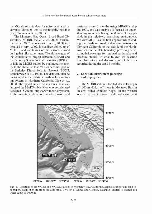
The MOBB station is located at a water depthof 1000 m, 40 km off-shore in Monterey Bay, inan area called «Smooth ridge» on the westernside of the San Gregorio Fault, and closer to it
Fig. 1. Location of the MOBB and MOISE stations in Monterey Bay, California, against seafloor and land to-pography. Fault lines are from the California Division of Mines and Geology database. MOBB is located at awater depth of 1000 m.
610
Barbara Romanowicz, Debra Stakes, David Dolenc, Douglas Neuhauser, Paul McGill, Robert Uhrhammer and Tony Ramirez
than was MOISE (fig. 1). The planned MARS ca-ble route is down the center of Smooth ridge andwith a termination near the MOBB site.
The San Gregorio Fault (SGF) splays fromthe SAF at the Golden Gate and extends southpast the San Francisco Peninsula and Santa Cruzmountains, mostly off-shore. It is the principalactive fault west of the SAF in central coastalCalifornia, yet it remains the largest known faultwhose seismogenic potential is not well charac-terized in this region. However, Begnaud andStakes (2000) and Begnaud et al. (2000) used atemporary off-shore seismic network to demon-strate the unusually high seismicity levels of theNorthern SGF, dominated by compressionalmechanisms as well as an east-dipping focalplane (Simila et al., 1998). The SGF is thought tobe capable of M>6 earthquakes, making theMOBB site particularly interesting from the tec-tonic and seismic hazards point of view. Usingrefined crustal velocities based on the results ofBegnaud et al. (2000), Simila et al. (1998) relo-cated the 1926 M>6 doublet to show that the firstevent occurred on the Northern SGF followed by
the second on the adjacent Monterey Bay faultzone.
The coseismic geodetic slip on the SAF dur-ing the 1906 earthquake and the Late Holocenegeologic slip rate on the San Francisco peninsu-la and southward are about 50-70% of their values north of San Francisco (Thatcher et al.,1997; Schwartz et al., 1998). Review by theWorking Group on Northern California Earth-quake Potential (1996) suggests that the slip rateon the SAF in the Santa Cruz mountains is about14 mm/yr, which is 58% of the slip rate north ofSan Francisco, so the rest of the slip must be ac-commodated by other faults, both on-land andoff-shore. This slip gradient reflects partitioningof the plate boundary slip onto the San Gregorio,Sargent and other faults south of the GoldenGate. Because of the limited on-shore extent,few detailed geologic studies have been conduct-ed to evaluate the style and rate of late Quater-nary deformation along this complex fault zone.
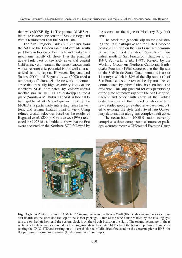
The ocean-bottom MOBB station currentlycomprises a three-component seismometer pack-age, a current meter, a Differential Pressure Gauge
Fig. 2a,b. a) Photo of a Guralp CMG-1TD seismometer in the Byerly Vault (BKS). Shown are the various cir-cuit boards on the sides and the top of the sensor package. Three of the nine batteries used by the leveling sys-tem are on the left front and the system clock is on the circuit board on the right. The seismometers are in the µmetal shielded container mounted on leveling gimbals in the center. b) Photo of the titanium pressure vessel con-taining the CMG-1TD and resting on a ~1 cm thick bed of kiln dried fine sand on the concrete pier at BKS, forthe purpose of noise comparisons (Uhrhammer et al., in prep.).
a
b
611
The Monterey Bay broadband ocean bottom seismic observatory
(DPG) and a recording and battery package. Thedata logger, battery, and DPG are contained in amodular frame which is removed and replacedwhen the ROV services the system. This config-uration permits hardware and software upgradesto take place as required. For instance, the DPG(Cox et al., 1984) was not present in the initialdeployments, but was added later during a dataretrieval dive in September, 2002.
The seismic package contains a low-power(2.2 W), three-component CMG-1T broadbandseismometer system, built by Guralp Inc., with a24-bit digitizer, a leveling system, and a preci-sion clock (fig. 2a). The seismometer package ismounted in a cylindrical titanium pressure ves-sel 54 cm in height and 41 cm in diameter (fig.2b), custom built by the MBARI team and out-fitted for underwater connection. The compo-nent design of the instruments permit the sensor,datalogger, and current meter to be carried to theseafloor separately, then tested and connected insitu. This component design permits us to up-date software, change batteries and replace in-struments without disturbing the sensor pack-
age. The system has been designed to permit aGPS time mark, applied during an ROV visit, toestablish the offset and drift rate of the Guralpclock. These errors are recorded and the timingof the seismic data is corrected in post-process-ing. The clock is not adjusted in situ to preventabrupt jumps in the time marking of the data.Establishing these corrections on the seafloorand after the system has reached thermal equi-librium is a critically important feature for long-term autonomous deployments.
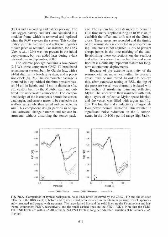
Because of the extreme sensitivity of theseismometer, air movement within the pressurevessel must be minimized. In order to achievethis, after extensive testing at BSL, the top ofthe pressure vessel was thermally isolated withtwo inches of insulating foam and reflectiveMylar. The sides were then insulated with mul-tiple layers of reflective Mylar space blanket,and the vessel was filled with argon gas (fig.2b). The low thermal conductivity of argon al-lows better thermal insulation. This resulted insignificant noise reduction on the 3 compo-nents, in the 10-100 s period range (fig. 3a,b).
Fig. 3a,b. Comparison of typical background noise PSD levels observed by the CMG-1TD and the co-sitedSTS-1’s in the BKS vault, a) before and b) after it had been installed in the titanium pressure vessel, appropri-ately insulated and purged with argon gas. The large dashed line and the solid lines are the Z component and hor-izontal component PSD’s, respectively, and the small dashed lines are the STS-1 PSD’s. Note that the CMG-1TD PSD levels are within ∼5 dB of the STS-1 PSD levels at long periods after insulation (Uhrhammer et al.,in prep.).
a b
612
Barbara Romanowicz, Debra Stakes, David Dolenc, Douglas Neuhauser, Paul McGill, Robert Uhrhammer and Tony Ramirez
Near-bottom water currents are measuredby a Falmouth Scientific 2D-ACM acousticcurrent meter. It is held by a small standalonefixture and measures the current speed and di-rection about one meter above the seafloor. Therecording system is a GEOSense LP1 data log-ger with custom software designed to acquireand record digital data from the Guralp sensorand from the current meter over RS-232 serialinterfaces, as well as analog data from the DPG.The seismic data are sampled at 20 Hz and thecurrent meter and DPG are sampled at 1 Hz.Data are stored on a 6-GB, 2.5-inch disk drive.All the electronics, including the seismometer,current meter, and DPG, are powered by a sin-gle 10 kWh lithium battery.
All installations were done using the MBARIship Point Lobos and the ROV Ventana. Prior tothe instrumentation deployment, the MBARI
team manufactured and deployed a 1181 kg gal-vanized steel trawl-resistant bottom mount tohouse the recording and power systems, and in-stalled a 53 cm diameter by 61 cm deep cylindri-cal PVC caisson to house the seismometer pres-sure vessel. The bottom mount for the recordingsystem was placed about 11 m away from thecaisson to allow the future exchange of therecording and battery package without disturbingthe seismometer. The seismometer package wastested extensively at BSL, then brought toMBARI where its internal clock drift was cali-brated against GPS time in an environmental testchamber at seafloor temperature.
The actual deployment occurred over 3 days(04/09-11/2002). On the first dive, the seismome-ter package was lowered into the PVC caisson(fig. 4a), and its connection cable brought to thesite of the recording unit. On the second dive, the
Fig. 4a-c. MOBB installation snapshots. a) Theseismometer package is being lowered into the holebounded by the PVC pipe, held by the arm of theROV Ventana. b) The recording and battery packageis being installed inside the trawl-resistant mount. c)The ROV arm (at front) is connecting the currentmeter cable to the recording system. The connectorof the seismometer package on the right is already inplace.
a b
c
613
The Monterey Bay broadband ocean bottom seismic observatory
recording package was emplaced in its trawl-re-sistant mount (fig. 4b), and connected to the seis-mometer package (fig. 4c). Tiny (0.8 mm diame-ter) glass beads were poured into the caisson un-til the seismometer was completely covered, tofurther isolate it from water circulation, as dictat-ed by lessons learned from previous experiments(e.g., Sutton et al., 1992; Duennebier and Sutton,1995). The seismometer package is now buried atleast 10 cm beneath the seafloor. On the thirddive, the ROV immobilized the cable between theseismometer and recording package with steel«wickets» inserted into the sediment. It then con-
nected the seismometer to the recording system,leveled and recentered the seismometer, and ver-ified that everything was operational. Finally, thecurrent meter was installed and connected to therecording system.
On April 22nd, 2002, the ROV returned to theMOBB site to check the functioning of the seis-mometer and recording system. Some slight set-tling of the seismometer pressure vessel had oc-curred, and so the seismometer was recenteredelectronically. Over 3 Mb of data were then down-loaded from the recording system over a periodof about two and a half hours, using a 9600 bps
Fig. 5. Mass position data, for portions of the time period 11/04/2002-07/01/2003, showing the progressive set-tling of the seismometers. At periods longer than the free period of the seismic sensor, the mass position is isproportional to tilt on the horizontal components, and to perturbations in gravity on the vertical component. Themass position has therefore been converted to acceleration (vertical component, MMZ) and tilt (horizontal com-ponents (MMN, MME). The large steps on the horizontal components are associated with: 1) installation (day100); 2) re-centering (day 112, day 263). There is a smaller step on day 134, associated with a local Mw 4.95earthquake. The vertical component data have been detrended by subtracting a running 36 h average (±18 h)from each 1/2 h duration smoothed data sample, to bring out the clearly visible tide signal.
614
Barbara Romanowicz, Debra Stakes, David Dolenc, Douglas Neuhauser, Paul McGill, Robert Uhrhammer and Tony Ramirez
serial data connection through the ROV. Thesedata included the recordings of two regionalearthquakes in California and two teleseismicevents that occurred in Guerrero, Mexico and inNorthern Chile.
The site was revisited two months later, onJune 27th, to check the functioning of the sys-tem and replace the data recording and batterymodule, in the first of a series of such divesplanned for the next 3 years. The followingfunctions were performed:
1) Disconnected the current meter and seis-mometer from old datalogger.
2) Removed old datalogger frame with da-talogger and batteries from the trawl-resistantmount.
3) Installed new datalogger frame in thetrawl-resistant mount.
4) Connected the current meter to the newdatalogger.
5) Connected the ROV to the new datalog-ger and verified that the datalogger was opera-tional.
6) Connected the seismometer to the newdatalogger, and monitored its reboot.
7) Centered the seismometer.8) Re-centered the seismometer.9) Verified that the Guralp was receiving the
GPS clock signals from the ROV (NMEA timemessages and pulse per second), and recorded theclock offset. During this dive, the Guralp clockwas not resynchronized to GPS time.
10) Brought the old datalogger frame withdatalogger and batteries back to the ship.
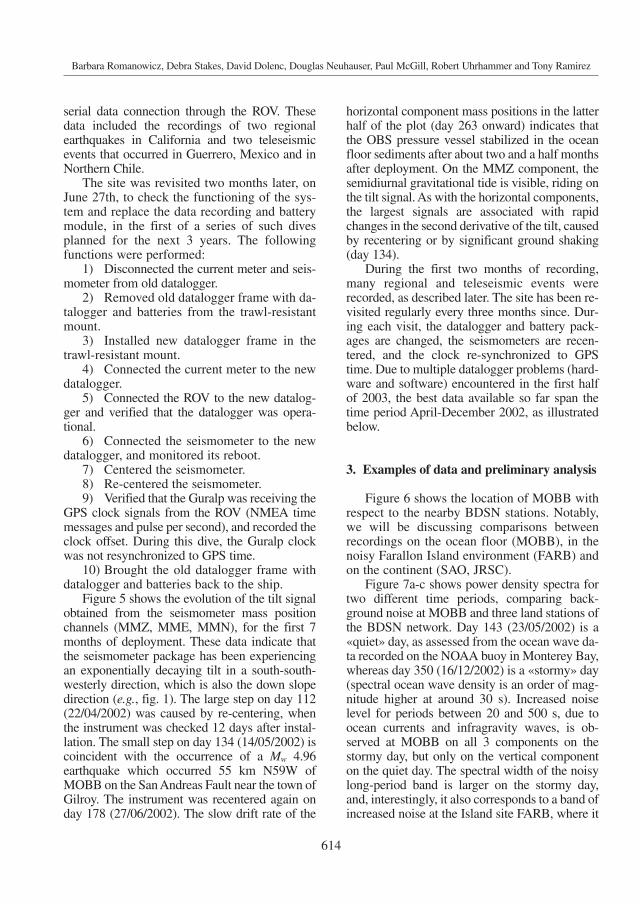
Figure 5 shows the evolution of the tilt signalobtained from the seismometer mass positionchannels (MMZ, MME, MMN), for the first 7months of deployment. These data indicate thatthe seismometer package has been experiencingan exponentially decaying tilt in a south-south-westerly direction, which is also the down slopedirection (e.g., fig. 1). The large step on day 112(22/04/2002) was caused by re-centering, whenthe instrument was checked 12 days after instal-lation. The small step on day 134 (14/05/2002) iscoincident with the occurrence of a Mw 4.96earthquake which occurred 55 km N59W ofMOBB on the San Andreas Fault near the town ofGilroy. The instrument was recentered again onday 178 (27/06/2002). The slow drift rate of the
horizontal component mass positions in the latterhalf of the plot (day 263 onward) indicates thatthe OBS pressure vessel stabilized in the oceanfloor sediments after about two and a half monthsafter deployment. On the MMZ component, thesemidiurnal gravitational tide is visible, riding onthe tilt signal. As with the horizontal components,the largest signals are associated with rapidchanges in the second derivative of the tilt, causedby recentering or by significant ground shaking(day 134).
During the first two months of recording,many regional and teleseismic events wererecorded, as described later. The site has been re-visited regularly every three months since. Dur-ing each visit, the datalogger and battery pack-ages are changed, the seismometers are recen-tered, and the clock re-synchronized to GPStime. Due to multiple datalogger problems (hard-ware and software) encountered in the first halfof 2003, the best data available so far span thetime period April-December 2002, as illustratedbelow.
3. Examples of data and preliminary analysis
Figure 6 shows the location of MOBB withrespect to the nearby BDSN stations. Notably,we will be discussing comparisons betweenrecordings on the ocean floor (MOBB), in thenoisy Farallon Island environment (FARB) andon the continent (SAO, JRSC).
Figure 7a-c shows power density spectra fortwo different time periods, comparing back-ground noise at MOBB and three land stations ofthe BDSN network. Day 143 (23/05/2002) is a«quiet» day, as assessed from the ocean wave da-ta recorded on the NOAA buoy in Monterey Bay,whereas day 350 (16/12/2002) is a «stormy» day(spectral ocean wave density is an order of mag-nitude higher at around 30 s). Increased noiselevel for periods between 20 and 500 s, due toocean currents and infragravity waves, is ob-served at MOBB on all 3 components on thestormy day, but only on the vertical componenton the quiet day. The spectral width of the noisylong-period band is larger on the stormy day,and, interestingly, it also corresponds to a band ofincreased noise at the Island site FARB, where it
615
The Monterey Bay broadband ocean bottom seismic observatory
Fig. 6. Location of MOBB (and MOIS) with respect to nearby broadband stations of the Berkeley Digital SeismicNetwork (BDSN). FARB is located on the Farallon Islands. MOBB is located just west of the San Gregorio Fault.
Fig. 7a. Comparison of noise recorded at MOBB and 2 other stations of the BDSN network, on two days in 2002when no significant earthquake signals were recorded: a «quiet day» (143), and a «stormy» day (350), as assessed bythe mean wave height recordings at a nearby NOAA buoy, located in Monterey Bay. The USGS high- and low-noisemodels for land stations are shown in black. Increased noise level for periods between 20 and 500 s, due to ocean cur-rents and infragravity waves, is observed at MOBB, as well as at the island station FARB. The noise level at MOBBbetween 10 and 20 s is comparable to the land station YBH, one of the quietest stations of the BDSN. See fig. 6 forFARB and SAO locations. Station YBH is 560 km north of MOBB. Here it is shown the vertical component.
616
Barbara Romanowicz, Debra Stakes, David Dolenc, Douglas Neuhauser, Paul McGill, Robert Uhrhammer and Tony Ramirez
is largest on the East component. This most like-ly indicates loading of shallow water around thesmall Farallon Island by gravity waves, similarlyto what is observed in Hawaii (Stephen et al.,2003). We are currently investigating the sourceof this noise in more detail. In particular, itshould be correlated with the DPG data, if it is in-deed due to gravity waves generated by breakingwaves at the coastline (Webb et al., 1991). Thebell shape of this noise peak is in agreement withtheoretical calculations by Araki et al. (2004). Onthe other hand, the noise level at MOBB between30 and 100 s on a quiet day is comparable to thenoise level at the island station FARB on astormy day. The «low noise notch» (Webb, 1998)is very narrow at MOBB (10-30 s), and containsthe single-frequency micro-seismic peak (12 s),
Fig. 7b,c. Comparison of noise recorded at MOBB and 2 other stations of the BDSN network, on two days in2002 when no significant earthquake signals were recorded: a «quiet day» (143), and a «stormy» day (350), as as-sessed by the mean wave height recordings at a nearby NOAA buoy, located in Monterey Bay. The USGS high-and low-noise models for land stations are shown in black. Increased noise level for periods between 20 and 500 s,due to ocean currents and infragravity waves, is observed at MOBB, as well as at the island station FARB. Thenoise level at MOBB between 10 and 20 s is comparable to the land station YBH, one of the quietest stations ofthe BDSN. See fig. 6 for FARB and SAO locations. Station YBH is 560 km north of MOBB. b) North component;c) east component.
b
c
but the level of noise is comparable to the landstation YBH, one of the quietest BDSN stations.The corresponding «double-frequency» micro-seismic peak around 6 s is visible at all stationsmost of the time, but on day 350, it is hidden byhigher amplitudes between 2 and 4 s at MOBB.On day 143, two additional narrow-band micro-seismic peaks are clearly resolved at MOBB(around 2.5 and 4 s). These could be related to acombination of local sea-state and distant storms(e.g., Bro-mirski and Duennebier, 2002). Theyare clearly distinct in frequency from those ob-served in the open sea (i.e., Stephen et al., 2003).
Noise levels at frequencies higher than 2 Hzand lower than 200 s are comparable to those ob-served at some of the land stations. FARB (islandsite) is sometimes noisier at long periods, but the
617
The Monterey Bay broadband ocean bottom seismic observatory
Fig. 8. Comparison of instrument responses of theCMG-1T at MOBB and the CMG-3T at FARB.
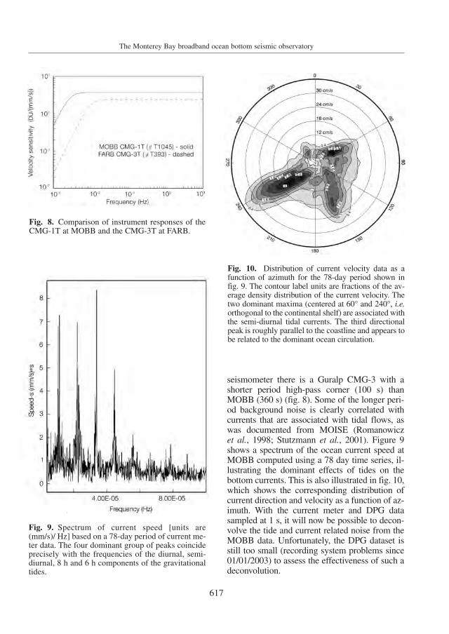
Fig. 9. Spectrum of current speed [units are(mm/s)/ Hz] based on a 78-day period of current me-ter data. The four dominant group of peaks coincideprecisely with the frequencies of the diurnal, semi-diurnal, 8 h and 6 h components of the gravitationaltides.
Fig. 10. Distribution of current velocity data as afunction of azimuth for the 78-day period shown infig. 9. The contour label units are fractions of the av-erage density distribution of the current velocity. Thetwo dominant maxima (centered at 60° and 240°, i.e.orthogonal to the continental shelf) are associated withthe semi-diurnal tidal currents. The third directionalpeak is roughly parallel to the coastline and appears tobe related to the dominant ocean circulation.
seismometer there is a Guralp CMG-3 with ashorter period high-pass corner (100 s) thanMOBB (360 s) (fig. 8). Some of the longer peri-od background noise is clearly correlated withcurrents that are associated with tidal flows, aswas documented from MOISE (Romanowicz et al., 1998; Stutzmann et al., 2001). Figure 9shows a spectrum of the ocean current speed atMOBB computed using a 78 day time series, il-lustrating the dominant effects of tides on thebottom currents. This is also illustrated in fig. 10,which shows the corresponding distribution ofcurrent direction and velocity as a function of az-imuth. With the current meter and DPG datasampled at 1 s, it will now be possible to decon-volve the tide and current related noise from theMOBB data. Unfortunately, the DPG dataset isstill too small (recording system problems since01/01/2003) to assess the effectiveness of such adeconvolution.
618
Barbara Romanowicz, Debra Stakes, David Dolenc, Douglas Neuhauser, Paul McGill, Robert Uhrhammer and Tony Ramirez
Figures 11-13 illustrate observations thathave been recorded at MOBB during the twomonths period 10/04/2002-28/06/2002, andwhich were retrieved during the first dataloggerexchange, on 29/06/2002.
Figure 11 shows a component-by-com-ponent comparison of the recording of the26/04/2002 Mw 7.1 teleseism in the Mariana Is-lands at MOBB and 3 nearby BDSN stations(see location on fig. 6). The comparison showsconsistency between the recordings of MOBBand nearby stations. On the horizontal compo-nents, there appears to be some signal-generat-ed noise following the S-waves and the Lovewave, which is associated with ringing in the
shallow mud layers as we will show below. Infig. 12, such ringing is clearly demonstrated fora deep earthquake (17/11/2002, depth = 459km, Mw= 7.3). Only the vertical component P-wave portion of the seismograms is displayed,filtered in two pass-bands. Signal-generatednoise is very apparent in the P-waves in the0.03-0.3 Hz pass-band, where the P-wave atMOBB displays a 3 min long coda. The ringingis narrow-band and disappears at frequencieslower than 0.1 Hz. Such observations should behelpful in understanding the triggering of sub-marine landslides in strong motion events, andmay be relevant for ocean floor structures suchas oil platforms and pipelines. On the other
Fig. 11. Comparison of vertical, N and E component records of the 26/04/2002 Mw 7.1 Mariana earthquake(depth = 85.7 km, distance = 85.2°, azimuth = 283° from MOBB), at MOBB and 3 stations of the BDSN. Therecords have been band-pass filtered between 10-100 s.
Fig. 12. Comparison of vertical component records at stations FARB, JRSC, MOBB and SAO for the deepKurile Island earthquake of 17/11/2002 (Mw=7.3; depth = 459 km; distance to MOBB = 65°). The data areshown in two pass-bands: 0.03-0.1 Hz and 0.03-0.3 Hz to emphasize the narrow-band character of the ringingin the MOBB P-wave data. Clearly visible in the lower frequency band are the P, pP and sP arrivals.
11 12
619
The Monterey Bay broadband ocean bottom seismic observatory
seismic events and could be similarly removed.On the vertical component, the water reflectionof the P-wave is clearly seen 1.3 s after the P-wave. In spite of these strong site effects, thesedata can be used in moment tensor studies, as il-lustrated in fig. 15, which shows the results of amoment tensor inversion using a time domainwhole waveform methodology (Dreger and Ro-manowicz, 1994). A robust solution is obtainedusing data from 5 stations, including data fromMOBB. The waveform fit at MOBB is out-standing with a 92.8% variance reduction. Theaddition of MOBB to the existing BDSN sta-tions in this particular case provides an addi-tional SH lobe but, since 3 SH lobes are alreadysampled by other BDSN stations, this particularstrike-slip mechanism is well constrained inany case. However, this example serves to showthat the MOBB data are well calibrated andhave potential for providing valuable con-straints in moment tensor studies of events of
hand, this type of noise may be unavoidable ina shallow buried installation. We are currentlyevaluating ways to eliminate this signal-gener-ated noise by post-processing. One possibilityis to design an «observational» transfer-func-tion, using data from near-by land stations thatdo not show the ringing. This is illustrated infig. 13, where we show a comparison of origi-nal P-wave train at MOBB (blue) and JRSC(green) and «cleaned» MOBB data (red) afterremoval of the corresponding transfer function.We are working on combining this type of pro-cessing with direct modelling of the ringing ef-fect, by computing theoretical transfer func-tions based on simple sediment layer models(Uhrhammer et al., 2003; Dolenc et al., 2006)that can be obtained from local studies (e.g.,Begnaud et al., 2000).
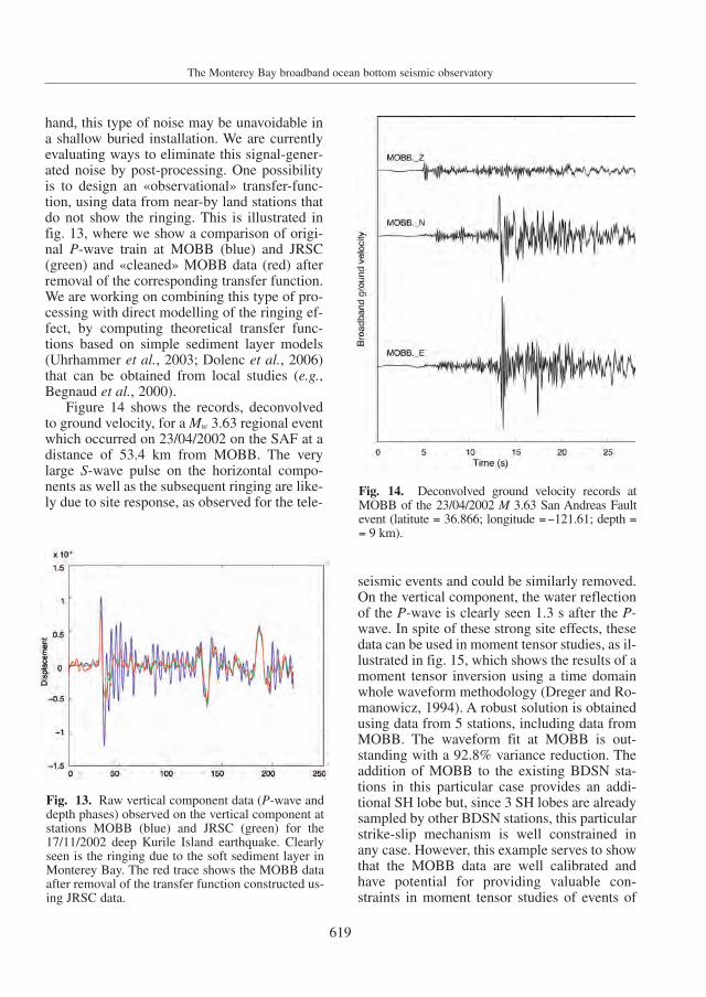
Figure 14 shows the records, deconvolvedto ground velocity, for a Mw 3.63 regional eventwhich occurred on 23/04/2002 on the SAF at adistance of 53.4 km from MOBB. The verylarge S-wave pulse on the horizontal compo-nents as well as the subsequent ringing are like-ly due to site response, as observed for the tele-
Fig. 13. Raw vertical component data (P-wave anddepth phases) observed on the vertical component atstations MOBB (blue) and JRSC (green) for the17/11/2002 deep Kurile Island earthquake. Clearlyseen is the ringing due to the soft sediment layer inMonterey Bay. The red trace shows the MOBB dataafter removal of the transfer function constructed us-ing JRSC data.
Fig. 14. Deconvolved ground velocity records atMOBB of the 23/04/2002 M 3.63 San Andreas Faultevent (latitute = 36.866; longitude =−121.61; depth == 9 km).
620
Barbara Romanowicz, Debra Stakes, David Dolenc, Douglas Neuhauser, Paul McGill, Robert Uhrhammer and Tony Ramirez
Fig. 15. Results of moment tensor inversions for the M 3.63 regional event shown in fig. 14. Top: inversion us-ing 4 stations of the BDSN and MOBB (BDM, BKS, CMB are bandpass filtered between 0.02 and 0.05 Hz;MHC and MOBB, between 0.05 and 0.10 Hz). Bottom: results of inversion using only MOBB, showing the goodfits of the single station solution to the other BDSN waveform data.
621
The Monterey Bay broadband ocean bottom seismic observatory
other types, such as reverse fault events in theCoast Ranges or strike slip events on faultscloser to the shore or off-shore.
To further demonstrate the consistency ofthe MOBB data, we also show the results of asingle station moment tensor inversion usingonly MOBB, and the comparison of the corre-sponding synthetic predictions with the actualdata at the four other BDSN stations. The singlestation solution results in a nearly identical fo-cal mechanism, but a slightly larger CLVDcomponent and scalar moment, which is not un-like other single station inversions.
4. Discussion and future work
Data collected at the MOBB site can beused for several purposes. They provide com-plementary constraints for regional crustal andupper mantle structure to land-based broadband stations, as well as for the study of earth-quakes along the San Andreas fault system.Currently, they are noisier than records fromland-based stations, so that only relativelylarge events can be successfully analyzed. Aswe have seen, there are two sources of in-creased noise: signal-generated noise due to re-verberation in the sediment pile, and back-ground noise generated by currents as well aslocal and distant waves in the ocean. The firsttype of noise can be dealt with by designingappropriate deconvolution filters. In particular,the vicinity of high quality broadband land sta-tions of the BDSN provides a helpful refer-ence. The second type of noise is complex andtime variable, however, the combination ofMOBB and BDSN seismic data, current meterand DPG data, sampled at sufficiently highrates, as well as local and regional buoy data,provides a promising dataset to try to reducethe MOBB background noise – at least in theinfragravity wave band. Ultimately, the level ofsuccess that we may reach in this endeavor willprovide a reference for what can be expected ofdata from shallow-buried broadband oceanbottom systems.
Finally, the collection of these differenttypes of data and their geographical distributionalso provides an opportunity to further study
the generation of such infragravity waves, atleast in the particular setting of a relatively shal-low ocean bay, as was pioneered by Bromirskiand Duennebier (2002).
Acknowledgements
The MOBB station instrumentation and de-ployment was supported by funds to MBARIfrom the Lucile and David Packard Foundation,the NSF (grant OCE-9911392) and UC Berke-ley funds to BSL. We thank Doug Dreger forperforming the test moment tensor inversionand providing fig. 15. This is BSL Contribution04-11.
REFERENCES
ARAKI, E., M. SHINOHARA, S. SACKS, A. LINDE, T. KANAZA-WA and K. SUYEHIRO (2004): Improvement of seismicobservation in the ocean by use of seafloor boreholes,Bull. Seismol. Soc. Am., 94, 678-690.
BEAUDUIN, R., J.-P. MONTAGNER and J.-F. KARCZEWSKI
(1996): Time evolution of broadband seismic noiseduring the French pilot experiment OFM/SISMOBS,Geophys. Res. Lett., 23, 2995-2998.
BEGNAUD, M.L. and D.S. STAKES (2000): Constraining con-tinental margin seismicity by extending on-shore seis-mograph stations to critical off-shore sites, Bull. Seis-mol. Soc. Am., 90, 414-424.
BEGNAUD, M.L., K.C. MCNALLY, D.S. STAKES and V.A.GALLARDO (2000): A crustal velocity model for locat-ing earthquakes in Monterey Bay, California, Bull.Seismol. Soc. Am., 90, 1391-1408.
BERANZOLI, L., A. DE SANTIS, G. ETIOPE, P. FAVALI, F. FRU-GONI, G. SMRIGLIO, F. GASPARONI and A. MARIGO (1998):GEOSTAR a GEophysical and Oceanographic STationfor Abyssal Research, Physics Earth Planet. Inter., 108(2), 175-183.
BROMIRSKI, P. and F. DUENNEBIER (2002): The near-coastalmicroseism spectrum: spatial and temporal climate relationships, J. Geophys. Res., 107, doi: 10.1029/2001JB000265.
BUTLER, R., A.D. CHAVE, F.K. DUENNEBIER, D.R. YOERGER,R. PETITT, D. HARRIS, F.B. WOODING, A.D. BOWEN, J.BAILEY, J. JOLLY, E. HOBART, J.A. HILDEBRAND andA.H. DODEMAN (2000): Hawaii-2 Observatory pioneersopportunities for remote instrumentation in ocean stud-ies, Eos, Trans. Am. Geophys. Un., 81 (157), 162-163.
COLLINS, J.A., F.L. VERNON, J.A. ORCUTT, R.A. STEPHEN,K.R. PEAL, F.B. WOODING, F.N. SPIESS and J.A. HILDE-BRAND (2001): Broadband seismology in the oceans:lessons from the ocean seismic network pilot experi-ment, Geophys. Res. Lett., 28, 49-52.
COSOD II (1987): Report of the Second Conference on Sci-
622
Barbara Romanowicz, Debra Stakes, David Dolenc, Douglas Neuhauser, Paul McGill, Robert Uhrhammer and Tony Ramirez
entific Ocean Drilling, European Science Foundation,Strasbourg, France.
COX, C., T. DEATON and S. WEBB (1984): A deep-sea differ-ential pressure gauge, J. Atmos. Ocean. Technol., 1,237-245.
DOLENC, D., B. ROMANOWICZ, R. UHRHAMMER, P. MCGILL,D. NEUHAUSER and D. STAKES (2006): Identifying andremoving noise from the Monterey Ocean BottomBroadband seismic sation (MOBB) data, Geochem.Geophys. Geosys. (in press).
DREGER, D. and B. ROMANOWICZ (1994): Source character-istics of events in the San Francisco Bay region, USGSOpen-File Rep. No. 94-176, 301-309.
DUENNEBIER, J.K. and G.H. SUTTON (1995): Fidelity ofocean bottom seismic observations, Mar. Geophys.Res., 17, 535-555.
DZIEWONSKI, A., R.F.J.WILKENS, J. FIRTH and SHIPBOARD
SCIENTIFIC PARTY (1992): Proceedings of the OceanDrilling Program, Initial Rep., 136.
FORSYTH, D., A. DZIEWONSKI and B. ROMANOWICZ (1995):Scientific objectives and required instrumentation, inProceedings of Ocean Seismic Network Workshop‘Broadband Seismology in the Oceans: Towards a FiveYear Plan’, 8-18.
GEE, L., D. NEUHAUSER, D. DREGER, R. UHRHAMMER and B.ROMANOWICZ (2003): The rapid earthquake data inte-gration project, International Handbook of Earthquakeand Engineering Seismology, 81B, 1261-1273.
KASAHARA, J., T. SATO, H. MOMMA and Y. SHIRASAKI
(1998): A new approach to geophysical real-time meas-urements on a deep-seafloor using decommisionedsubmarine cables, Earth Planets Space, 50, 913-925.
MCGILL, P., D. NEUHAUSER, D. STAKES, B. ROMANOWICZ, T.RAMIREZ and R. UHRHAMMER (2002): Deployment of along-term broadband seafloor observatory in MontereyBay, Eos, Trans. Am. Geophys. Un., 83, F1008.
MONTAGNER, J.P. and Y. LANCELOT (Editors) (1995): Multi-disciplinary observatories on the deep seafloor, Reportof International Ocean Network Workshop Held atMarseille, France, 01/11-01/13, 1995 (published byINSU/CNRS, IFREMER, ODP-France).
MONTAGNER, J.P., B. ROMANOWICZ and J.F. KARCZEWSKI
(1994a): A first step toward an oceanic geophysical ob-servatory, Trans. Am. Geophys. Un., 75, 150-151.
MONTAGNER, J.P., J. F. KARCZEWSKI, B. ROMANOWICZ, S.BOUARICHA, P. LOGNONNE, G. ROULT, E. STUTZMANN, J.L.THIROT, J BRION, B. DOLE, D. FOUASSIER, J.-C. KOENIG,J.C. SAVARY, L. FLOURY, J. DUPOND, A. ECHARDOUR andH. FLOC’H (1994b): The french pilot experiment OFM-SISMOBS: first scientific results on noise level and eventdetection, Phys. Earth Planet. Inter., 84, 321-336.
PURDY, M. (Editor) (1995): Broadband seismology in theoceans: towards a five year plan, Report of Ocean Seis-mic Network Workshop (published by Joint Oceano-graphic Institutions).
PURDY, G.M. and A.M. DZIEWONSKI (Editors) (1988): Pro-ceedings of the Workshop on Broad-band DownholeSeismometers in the Deep Ocean, April 26-28, 1988,Woods Hole, Massachusetts, pp. 331.
ROMANOWICZ, B., D. NEUHAUSER, B. BOGAERT and D. OP-PENHEIMER (1994): Accessing Northern CaliforniaEarthquake Data Via Internet, Eos, Trans. Am. Geo-phys. Un., 75, 258-261.
ROMANOWICZ, B., D. STAKES, J. P. MONTAGNER, P. TARITS,R. UHRHAMMER, M. BEGNAUD, E. STUTZMANN, M. PA-SYANOS, J.F. KARCZEWSKI and S. ETCHEMENDY (1998):MOISE: a pilot experiment towards long term Seafloorgeophysical observatories, Earth Planets Space, 50,927-937.
ROMANOWICZ, B., D. STAKES, R. UHRHAMMER, P. MCGILL,D. NEUHAUSER, T. RAMIREZ and D. DOLENC (2003):The MOBB experiment: a prototype permanent off-shore ocean bottom broadband station, Eos, Trans. Am.Geophys. Un., 84, 325-332.
SCHWARTZ, D.P., D. PANTOSTI, K. OKUMURA, T.J. POWERS
and J.C. HAMILTON (1998): Paleoseismic investigationsin the Santa Cruz mountains, California: implicationsfor recurrence of large-magnitude earthquakes on theSan Andreas Fault, J. Geophys. Res., 103, 17,985-18,001.
SIMILA, G.W., V.A. GALLARDO, K.C. MCNALLY, M.L. BEG-NAUD and D.S. STAKES (1998): New investigation ofsignificant Monterey Bay area earthquakes (M>4.0,1926-79) utilizing data from a 1998 deployment ofPASSCAL Ref-Teks and master-event methods, Eos,Trans. Am. Geophys. Un., 79 (45), F589.
STAKES, D., B. ROMANOWICZ, J.P. MONTAGNER, P. TARITS,J.F. KARCZEWSKI, S. ETCHEMENDY, D. NEUHAUSER, P.MCGILL, J.-C. KOENIG, J.SAVARY, M. BEGNAUD and M.PASYANOS (1998): MOISE: Monterey bay Ocean bot-tom International Seismic Experiment, Eos, Trans.,Am. Geophys. Un., 79, 301-309.
STEPHEN, R.A., F.N. SPIESS, J.A. COLLINS, J.A. HILDEBRAND,J.A. ORCUTT, K.R. PEAL, F.L. VERNON and F.B. WOOD-ING (2003): The ocean seismic network pilot experi-ment, Geochem. Geophys. Geosys., 4, doi: 10.1029/2002GC000485.
STUTZMANN, E., J.P. MONTAGNER, A. SEBAI, W.C. CRAW-FORD, J. L. THIROT, P. TARITS, D. STAKES, B. ROMANOW-ICZ, J.F. KARCZEWSKI, J.C. KOENIG, J. SAVARY, D. NEU-HAUSER and S. ETCHEMENDY (2001): MOISE: a proto-type multiparameter ocean-bottom station, Bull. Seis-mol. Soc. Am., 81, 885-902.
SUTTON, G.H., F.K. DUENNEBIER and B. IWATAKI (1992):Coupling of ocean bottom seismometers to soft bot-tom, Mar. Geophys. Res., 5, 35-51.
SUYEHIRO, K., T. KANAZAWA, N. HIRATA, M. SHINOHARA andH. KINOSHITA (1992): Broadband downhole digitalseismometer experiment at site 794, Proc. ODP, Sci.Results, 127/128, 1061-1073.
SUYEHIRO, K., J.P. MONTAGNER, A.M. DZIEWONSKI and B.ROMANOWICZ (1995): The international ocean networkstructure, in Proceedings ION/ODP International Work-shop ‘Multidisciplinary Observatories on the Deep Sea-floor’, Marseille, 61-72.
SUYEHIRO, K., E. ARAKI, S. AMASAO and T. KANAZAWA
(2002): Deep-sea borehole observatories ready andcapturing seismic waves in the Western Pacific, Eos,Trans. Am. Geophys. Un., 83, 624-625.
THATCHER, W., G. MARSHALL and M. LISOWSKI (1997): Res-olution of fault slip along the 470-km-long rupture ofthe great 1906 San Francisco earthquake and its impli-cations, J. Geophys. Res., 102, 535-5367.
623
The Monterey Bay broadband ocean bottom seismic observatory
UHRHAMMER, R. (2003): MOBB: data analysis from anocean floor broadband seismic observatory, Eos, Trans.Am. Geophys. Un., 84 (46), Abstr. S52D-0162.
UHRHAMMER, R., B. ROMANOWICZ, D. NEUHAUSER, D.STAKES, P. MCGILL and T. RAMIREZ (2002): Instrumenttesting and first results from the MOBB Observatory,Eos, Trans. Am. Geophys. Un., 83, F1008.
WEBB, S.C. (1998): Broadband seismology and noise under
the ocean, Rev. Geophys. Space Phys., 36, 105-142.WEBB, S.C., X. ZHANG and W. CRAWFORD (1991): Infra-
gravity waves in the deep ocean, J. Geophys. Res., 96,2723-2736.
WORKING GROUP ON NORTHERN CALIFORNIA EARTHQUAKE
POTENTIAL (1996): Database of potential sources forearthquakes larger than magnitude 6 in Northern Cali-fornia, US Geol. Surv. Open File Rep. 96-705, pp. 40.


![Seismic Broadband Ocean-Bottom Data and Noise …bullard.esc.cam.ac.uk/~tilmann/BSSA_06.pdf · [ob24], PMD seismometer and hydrophone [ob29], Lamont-Doherty Earth Observatory [LDEO]](https://static.documents.pub/doc/80x56/5a78b7d37f8b9a07028d2d5b/seismic-broadband-ocean-bottom-data-and-noise-tilmannbssa06pdfob24-pmd.jpg)


