GEOLOGY, PHYSIOGRAPHY, AND GROUNDWATER RESOURCES Within the Basin and Range Province, the Earth's crust (and upper mantle) has been stretched up to 100% of its original width. The entire region has been subjected to extension that thinned and cracked the crust as it was pulled apart, creating large faults. Along these roughly north-south-trending faults mountains were uplifted and valleys down-dropped, producing the distinctive alternating pattern of linear mountain ranges and valleys of the Basin and Range province (USGS, 2005). These valleys are broad, internally- drained bolsons, or basins, underlain by aquifers. This is especially evident in the southeastern part of the study area where the Quitman and Eagle mountains alternate with the Hueco, Red Light Draw, Eagle Flat bolsons (Langford, 1993), and in east-northeastern part of the study area where the Salt Basin is bound by the Guadalupe/Delaware Mountains on the east and Sierra Diablo Mountains on the west. Area physiography is shown in Figure 2. The TWDB identifies one major aquifer, the Hueco Bolson, and three minor aquifers, the West Texas Bolsons, the Capitan Reef Complex, and the Bone Spring-Victorio Peak aquifers in Hudspeth County (Hopkins and Ashworth, 1995). The TWDB also identifies the Diablo Plateau as a possible water source (George and others, 2005). In addition to these aquifers, the FWTRWPG has identified the Rio Grande alluvium as an additional aquifer (FWTRWPG, 2001). However, George and others (2005) consider the Rio Grande Alluvium aquifer to be part of the Hueco Bolson aquifer. Figures 5, 6, and 7 show the geology, stratigraphy, and geologic structure of the study area. Bone Spring-Victorio Peak Aquifer The Bone Spring Limestone and Victorio Peak Limestone together form the Bone Spring-Victorio Peak aquifer, one of two minor aquifers of Permian age, as identified by the TWDB, located within Hudspeth County. The Victorio Peak is exposed in a swath extending from north central to east central (Sierra Diablo Mountain) Hudspeth County. The Bone Spring is only exposed in the Sierra Diablo Mountain area. The Bone Spring and Victorio Peak formations are composed of as much as 2,000 feet of limestone beds and contain groundwater in joints, fractures, and solution cavities (Bureau of Economic Geology, 1983). The current mapped boundaries of the Bone Spring-Victorio Peak aquifer only occupy the eastern edge of the Diablo Plateau west of the Guadalupe Mountains in northeast Hudspeth County (Figure 8). The aquifer extends northward into the Crow Flats area of New Mexico. The formations that make up this aquifer extend much farther than the boundaries of the current delineated aquifer. The Bone Spring and Victorio Peak formations extend to the south beneath the Salt Basin, to the west and southwest beneath the Diablo Plateau, and to the northwest into New Mexico (Mullican and Mace, 2001). Since the 1995 TWDB delineation of the boundaries of this aquifer, more recent studies conducted on the Bone Spring- Victorio Peak aquifer indicate that the boundary of the aquifer should be expanded. George and others (2005) suggest new boundaries for the Bone Spring-Victorio Peak aquifer in Texas that are focused on containing all of the groundwater flowing into the Dell Valley and are based on geologic and hydrogeologic information instead of the extent of irrigable lands (Figure 9). This new boundary is defined on the east by the center line of the Salt Basin, the original, pre-development discharge area for the groundwater flow system. The southern boundary follows the Bitterwell Break -9-
Transcript
GEOLOGY, PHYSIOGRAPHY, AND GROUNDWATER RESOURCES
Within the Basin and Range Province, the Earth's crust (and upper mantle) has been stretched up to 100% of its original width. The entire region has been subjected to extension that thinned and cracked the crust as it was pulled apart, creating large faults. Along these roughly north-south-trending faults mountains were uplifted and valleys down-dropped, producing the distinctive alternating pattern of linear mountain ranges and valleys of the Basin and Range province (USGS, 2005). These valleys are broad, internally-drained bolsons, or basins, underlain by aquifers. This is especially evident in the southeastern part of the study area where the Quitman and Eagle mountains alternate with the Hueco, Red Light Draw, Eagle Flat bolsons (Langford, 1993), and in east-northeastern part of the study area where the Salt Basin is bound by the Guadalupe/Delaware Mountains on the east and Sierra Diablo Mountains on the west. Area physiography is shown in Figure 2.
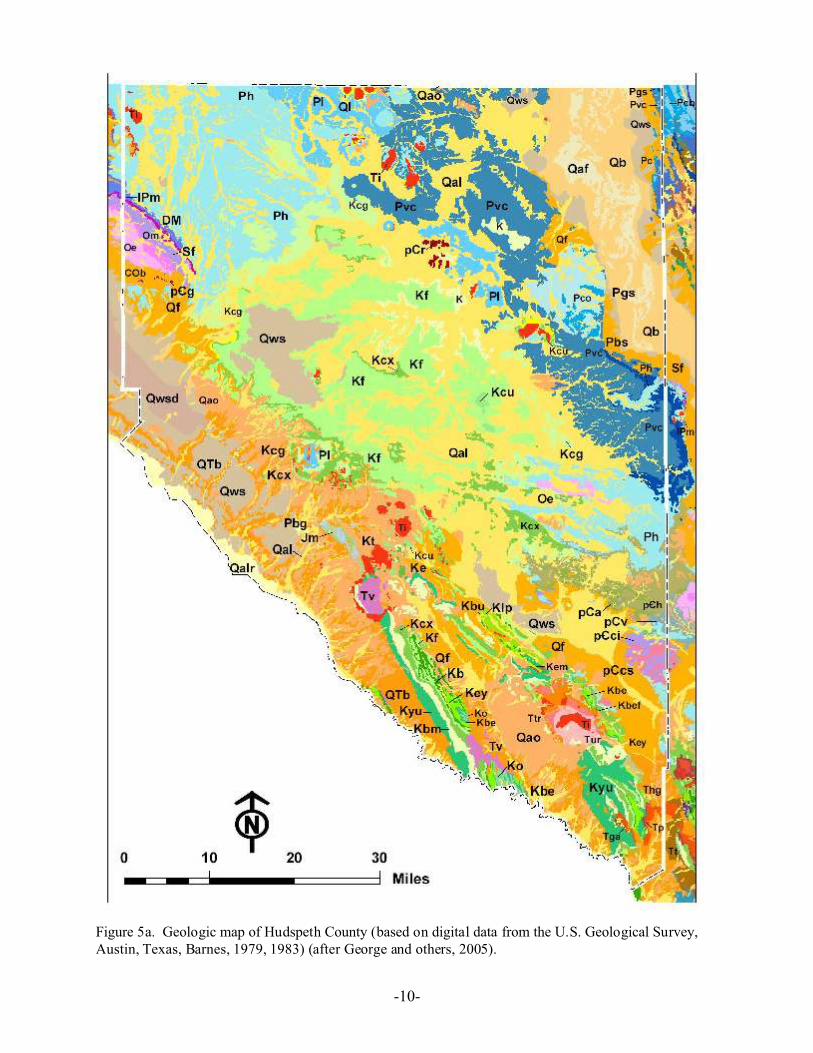
The TWDB identifies one major aquifer, the Hueco Bolson, and three minor aquifers, the West Texas Bolsons, the Capitan Reef Complex, and the Bone Spring-Victorio Peak aquifers in Hudspeth County (Hopkins and Ashworth, 1995). The TWDB also identifies the Diablo Plateau as a possible water source (George and others, 2005). In addition to these aquifers, the FWTRWPG has identified the Rio Grande alluvium as an additional aquifer (FWTRWPG, 2001). However, George and others (2005) consider the Rio Grande Alluvium aquifer to be part of the Hueco Bolson aquifer. Figures 5, 6, and 7 show the geology, stratigraphy, and geologic structure of the study area.
Bone Spring-Victorio Peak Aquifer
The Bone Spring Limestone and Victorio Peak Limestone together form the Bone Spring-Victorio Peak aquifer, one of two minor aquifers of Permian age, as identified by the TWDB, located within Hudspeth County. The Victorio Peak is exposed in a swath extending from north central to east central (Sierra Diablo Mountain) Hudspeth County. The Bone Spring is only exposed in the Sierra Diablo Mountain area. The Bone Spring and Victorio Peak formations are composed of as much as 2,000 feet of limestone beds and contain groundwater in joints, fractures, and solution cavities (Bureau of Economic Geology, 1983).
The current mapped boundaries of the Bone Spring-Victorio Peak aquifer only occupy the eastern edge of the Diablo Plateau west of the Guadalupe Mountains in northeast Hudspeth County (Figure 8). The aquifer extends northward into the Crow Flats area of New Mexico. The formations that make up this aquifer extend much farther than the boundaries of the current delineated aquifer. The Bone Spring and Victorio Peak formations extend to the south beneath the Salt Basin, to the west and southwest beneath the Diablo Plateau, and to the northwest into New Mexico (Mullican and Mace, 2001). Since the 1995 TWDB delineation of the boundaries of this aquifer, more recent studies conducted on the Bone Spring-Victorio Peak aquifer indicate that the boundary of the aquifer should be expanded.
George and others (2005) suggest new boundaries for the Bone Spring-Victorio Peak aquifer in Texas that are focused on containing all of the groundwater flowing into the Dell Valley and are based on geologic and hydrogeologic information instead of the extent of irrigable lands (Figure 9). This new boundary is defined on the east by the center line of the Salt Basin, the original, pre-development discharge area for the groundwater flow system. The southern boundary follows the Bitterwell Break
-9-
Figure 5a. Geologic map of Hudspeth County (based on digital data from the U.S. Geological Survey, Austin, Texas, Barnes, 1979, 1983) (after George and others, 2005).
-10-
Figure 5b. Legend for Geologic Map of Hudspeth County (based on digital data from the U.S. Geological Survey, Austin, Texas, and Barnes, 1979, 1983) (after George and others, 2005).
-11-
Figure 6. Stratigraphic columns for selected areas in Hudspeth County (after George and others, 2005).
-12-
Figure 7. Regional structure map, far west Texas (modified from the 1990 Tectonic map of Texas, 1:750,000 scale) (after George and others, 2005).
-13-
Figure 8. Location of aquifers within the study area.
-14-
Figure 9. TWDB proposed new boundary for the Bone Spring–Victorio Peak aquifer (after George and others, 2005).
-15-
(Goetz, 1977; Boyd and Kreitler, 1986) out of the Salt Basin. The Bitterwell Break is a Tertiary normal fault that deforms the sediments of the Salt Basin. This feature reportedly corresponds to a groundwater divide (Nielson and Sharp, 1985; Boyd and Kreitler, 1986). The southern boundary follows the Bitterwell Break to where it meets the Babb Flexure. The Babb Flexure is a northwest-southeast trending, north-side-down monocline that formed in post-Early Pennsylvanian/pre-Hueco Limestone (Wolfcampian) time (Dickerson, 1980). The Babb Flexure coincides with a groundwater flow line. Since the Babb Flexure does not extend to the state line, George and others (2005) followed a flow line based on the potentiometric surface of Mayer (1995) and Mayer and Sharp (1998) that extends from the northwest end of the Babb Flexure to the state line. The northern boundary of the aquifer in Texas is then defined as the state line with New Mexico. This new, proposed boundary is to be presented the TWDB for approval as part of the 2007 State Water Plan.
Recharge to the Bone Spring-Victorio Peak aquifer comes from primarily the Sacramento River, but also from the Diablo Plateau (Texas)/Otero Mesa (New Mexico) and irrigation return flow (Scalapino, 1950; Ashworth, 1995). Groundwater flows into the Dell Valley area from the Sacramento Mountains in New Mexico through a set of northwest-southeast trending fractures (Mayer, 1995). Ashworth (1995) estimated that the Bone Spring-Victorio Peak aquifer received 90,000 to 100,000 acre-feet per year. Well yields differ widely from about 150 gallons per minute to more than 2,000 gallons per minute (Ashworth and Hopkins, 1995). Groundwater discharges from the Bone Spring-Victorio Peak aquifer through evaporation, interbasin flow, and pumping. Groundwater from the Sacramento Mountains and Otero Mesa in New Mexico and from the Diablo Plateau to the west flows into the northern Salt Basin where it evaporates (Chapman, 1984; Boyd and Kreitler, 1986; Kreitler and others, 1990; Mayer 1995; Mayer and Sharp, 1998). Evaporation rates on the salt flats could theoretically range from 49,000 to 243,000 acre-feet per year (Ashworth, 1995). Water quality ranges from slightly saline on the Diablo Plateau to moderately saline in the Dell Valley area (George and others, 2005).
Capitan Reef Complex Aquifer
The other identified minor aquifer of Permian age is the Capitan Reef Complex aquifer (Figure 8). This aquifer consists of the Permian age formations: Goat Seep Limestone; Capitan Limestone; and, Carlsbad Group. These units are composed of limestone, dolomitic limestone, dolomite, and sandstone with a thickness of up to 2,360 feet (Bureau of Economic Geology, 1983). Only a small part of the aquifer is located within the study area on the east of the Salt Basin outcropping in the far northeastern part of the county in the Guadalupe Mountains.
Regional groundwater flow in the aquifer is to the east and northeast (Hiss, 1975, 1980). Flow has been affected by the incision of the Pecos River and by development of petroleum and groundwater resources over the last 70 years (Hiss, 1975, 1980; Uliana, 2001). Near the Guadalupe Mountains, water-levels suggest that there is some flow from the Capitan Reef Complex aquifer into the Salt Basin. Kreitler and others (1990) suggest that groundwater from the Diablo Plateau may be flowing southeast through reef facies rocks buried under the Salt Basin.
The Capitan Reef Complex (Figure 8) is recharged primarily by rainfall (ranging from about 14 to 24 inches) over the Guadalupe, Glass, and Apache mountains (Ashworth and Hopkins, 1995). Muller and Price (1979) estimated that effective annual recharge of the Capitan Reef Complex aquifer is 12,500 acre-feet. Of this amount, 2,500 acre-feet recharges in the Diablo Farms area of Culberson County and 10,000 acre-feet recharges in the Apache Mountains area. If the exposures in the Glass Mountains of Brewster County are included in the estimate, 2,100 acre-feet can be added to this total. Estimates of
-16-
natural recharge for the aquifer in the Guadalupe mountains range from 10,000 to 20,000 acre-feet per year (OSE/ISC, 2003).
Most of the groundwater pumped from the Capitan Reef Complex aquifer in Texas is used for oil reservoir water-flooding in Ward and Winkler counties. In many areas of Culberson and Hudspeth counties, the yields of wells are commonly more than 1,000 gallons per minute. A small amount is used to irrigate salt-tolerant crops in Pecos and Culberson counties. This aquifer generally contains water of poor quality and yields small to large quantities of moderately saline to brine water. The freshest quality water is produced from wells located on or near areas of recharge where the reef rock is exposed at the surface (Ashworth and Hopkins, 1995).
Diablo Plateau Aquifer
The Diablo Plateau aquifer (Figure 2) has not been identified as one of the major or minor aquifers of Texas. This aquifer falls under the “other” category for aquifers in Texas. The “other” category is intended to include locally significant aquifers. The extent of the boundaries coincides with the Diablo Plateau in the central part of Hudspeth County not including the part added to the redefined Bone Spring-Victorio Peak aquifer (Figure 9). The Diablo Plateau is an uplifted, east-northeast-dipping homoclinal structure (King, 1965; Barnes, 1983). The plateau is bounded by Tertiary and Quaternary normal faults to the south, east, and west and extends into New Mexico, where it is called the Otero Mesa (Henry and Price, 1985; Collins and Raney, 1991, 1997; Mayer, 1995).
The plateau consists of Permian and Cretaceous limestones interbedded with sandstones and shales. Formations outcropping on the plateau include the Cretaceous-aged Finley Limestone and Cox Sandstone and the Permian-aged Victorio Peak and Bone Spring limestones. Miocene to Holocene deposits overlie the older rock in drainage areas. Superimposed onto the general structure of the plateau are two northwest-southeast trending monoclines, the Babb and Victorio flexures (Figure 7). Like the Babb, the Victorio Flexure is a north-side-down monocline that formed in post-Early Pennsylvanian/pre-Hueco Limestone (Wolfcampian) time (Dickerson, 1980).
The Diablo Plateau can be subdivided into two aquifers based on water-level information (Kreitler and others, 1986, 1990; Mullican and Mace, 2001). The first aquifer is located in the Cretaceous limestones located in the southwestern part of the plateau, and the second aquifer is located in the Permian limestones underlying the Cretaceous rocks in the southwestern part of the plateau and outcropping just to the north in the north-central part of the plateau. The Permian rocks are the lateral equivalents to limestones of the Bone Spring-Victorio Peak aquifer to the northeast (Mullican and Mace, 2001).
Groundwater flows outward from the south-central part of the Diablo Plateau: southwest toward Hueco Bolson; northeast toward the Salt Basin; and, to the southeast toward the Finlay Mountains and northwest Eagle Flats. Most of the water flows down the structural dip toward the northeast. Only a minor amount of water flows into the Hueco Bolson (Mullican and others, 1987; Kreitler and others, 1990). The Permian and Cretaceous parts of the Diablo Plateau aquifers are vertically connected to one another and are laterally connected to a number other aquifers in the area. The Cretaceous aquifer is hydraulically connected to the Hueco Bolson aquifer to the west (Mullican and Senger, 1989, 1992), to the Salt Basin to the east, and to the Bone Spring-Victorio Peak aquifer to the northeast (Peckham, 1963; Young, 1975; Kreitler and others, 1990; Mayer, 1995; Mullican and Mace, 2001).
Most recharge on the plateau occurs through fractures along arroyos during storm rainfall and flooding allowing rapid recharge of the aquifer. Recharge occurs over the entire plateau (approximately 2,900
-17-
square miles) (Mullican and others, 1987; Kreitler and others, 1990) at a rate ranging from 0.008 to 0.276 inches/year (Mayer, 1995). The limestones of the plateau, due to faulting and dissolution, may have the ability to transmit large volumes of water (Mullican and Mace, 2001). In northwestern Hudspeth County several wells produced 40 to 300 gallons per minute with no drawdown (LBG-Guyton Associates, 2001). Water quality is generally slightly saline (total dissolved solids values of 1,000 to 3,000 mg/L) (George and others, 2005).
Hueco Bolson
Adjacent to area mountain ranges, basins have formed by extensional faulting allowing a thick sequence of Tertiary and Quaternary sediment to infill. These areas of sediment fill are called bolsons. The largest of these bolsons, the Hueco Bolson (Figure 8), forms the only TWDB-designated major aquifer within Hudspeth County. The Hueco Bolson aquifer extends from the Franklin Mountains in El Paso County to the southern end of the Quitman Mountains in Hudspeth County. The aquifer is bounded on the northeast by the Diablo Plateau and the Malone and Quitman Mountains and on the south by a series of mountain ranges extending to the southeast from Ciudad Juárez in Mexico to near the southernmost point of the Quitman Mountains in Texas. The Hueco Bolson consists of silt, sand, and gravel in the upper part and clay and silt in the lower part with a combined thickness of approximately 9,000 feet (Ashworth and Hopkins, 1995; FWTRWPG, 2001). Although, only the upper several hundred feet of the Hueco Bolson contain fresh to slightly saline water (Ashworth and Hopkins, 1995). The floor of the bolson in Hudspeth County slopes to the southwest from the Diablo Plateau escarpment and Quitman Mountains to the Rio Grande, from elevations of 3,600-4,600 feet to 3,300-3,550 feet (George and others, 2005).
The uppermost part of the Hueco Bolson aquifer includes the Rio Grande Alluvium. Some consider the Rio Grande Alluvium to be an aquifer, the Rio Grande Alluvium aquifer, separate from the Hueco Bolson aquifer. In their report, the TWDB considered the Rio Grande Alluvium to be part of Hueco Bolson aquifer. However, the report does discuss the Rio Grande Alluvium separately where necessary (George and others, 2005). The FWTRWPG set the Rio Grande apart from the Hueco Bolson because it is a source of irrigation water in El Paso and Hudspeth counties when flow in the river is insufficient to support agricultural water user groups. The water contained in the alluvium typically has high concentrations of total dissolved solids (FWTRWPG, 2001).
The Hueco Bolson is a major source of water for cities in El Paso and Hudspeth counties in the United States and for Ciudad Juárez in Mexico (FWTRWPG, 2001). The majority of the water in this aquifer is located in El Paso County with very little occurring in Hudspeth County. Dissolved solids concentrations in the upper part range from less than 500 mg/L to more than 1,500 mg/L with an average of 640 mg/L (Ashworth and Hopkins, 1995). There is no fresh water on the eastern edge of the aquifer (FWTRWPG, 2001). Historical large-scale groundwater withdrawals, especially from municipal well fields in the City of El Paso and in Ciudad Juárez, have caused major water-level declines which have significantly changed the direction of flow and chemical quality of groundwater (Ashworth and Hopkins, 1995).
Water-levels show that groundwater in the Hueco Bolson aquifer in Hudspeth County generally flows south and southwest from the Diablo Plateau and discharges along the Rio Grande. South of the Rio Grande the potentiometric surface also slopes to the river from mountains in Mexico (George and others, 2005). Very little recharge occurs in the Hueco Bolson. It has been shown that penetration of moisture after rainfall is restricted to the upper few feet of the unsaturated zone (Scanlon and others, 1991). Some minor recharge does occur in areas of fissured sediments underlain by fractures (Scanlon, 1992). Some
-18-
recharge also occurs in areas of exposed Cretaceous rocks along Quaternary normal faults (Mullican and Senger, 1992). The Hueco Bolson receives a minor amount of flow from the Diablo Plateau (Kreitler and others, 1987, 1990).
Gates and others (1980) estimated recharge for the entire area of the Hueco Bolson to be 14,000 acre-feet per year by assuming an annual average of 10 inches of precipitation per year and calculating the area for the Hueco Bolson contained within the United States. The Far West Texas Regional Water Plan (2001) indicates that recharge to the Hueco Bolson aquifer in El Paso County is 5,640 acre-feet per year (Meyer, 1976). An approximate estimation of recharge can be made by taking the 14,000 acre-feet per year estimate by Gates and others (1980) and subtracting the El Paso portion of 5,640 acre-feet per year by Meyer (1976) and subtracting the New Mexico portion of about 5,500 acre-feet per year estimated by Heywood and Yager (2003). The resulting recharge estimate for the Hudspeth County portion of the aquifer is about 2,800 acre-feet per year.
Groundwater in the Hueco Bolson discharges through pumping, seepage to the Rio Grande from the Rio Grande Alluvium, spring discharge, evaporation, and consumption by phreatotypes such as salt cedar (Mullican and Senger, 1992; TWDB and NMWRRI, 1997). Current well water withdrawal from the southeastern Hueco Bolson is limited to pumpage from smaller wells for municipal and livestock purposes (George and others, 2005). Well yields in the Texas part of the Hueco Bolson are as much as 1,800 gallons per minute in the El Paso area (Sheng and others, 2001), but the Hueco Bolson aquifer in Hudspeth County has little well yield data. The aquifer near Fort Hancock yielded 150 gallons per minute in an irrigation well (Mullican and Senger, 1992). An aquifer test done in the late 1980s in a Bureau of Economic Geology study was done at a sustained rate of approximately 25 gallons per minute for two weeks (Mullican and Senger, 1992).
West Texas Bolsons
As defined by the TWDB, the West Texas Bolsons aquifer (Figure 8) is a minor aquifer. This aquifer consists of ten smaller aquifers located within Culberson, Hudspeth, Jeff Davis, and Presidio counties. These smaller aquifers include Michigan Flat, Wild Horse Flat, Lobo Flat, Ryan Flat, Presidio Bolson, Redford Bolson, Green River Valley, Red Light Draw, Northwest Eagle Flat, and Southeast Eagle Flat. Of those areas, only the Green River Valley, Red Light Draw, Northwest Eagle Flat, and Southeast Eagle Flat are located within the study area. These bolsons are filled with Quaternary erosional material from adjacent mountains. Composition of bolson deposits depends on the composition of the rock units that make up the mountains, ranging from volcanics and limestones redeposited as alluvial fans to silt and clay lake deposits (FWTRWPG, 2001).
Green River Valley Bolson The Green River Valley Bolson lies in the southeasternmost corner of Hudspeth County between the Eagle Mountains, on the west, and the Van Horn Mountains, on the east, overlapping into Culberson, Jeff Davis, and Presidio counties. The Green River Valley Bolson consists of Cretaceous limestone, sandstone, conglomerate, siltstone, and Tertiary volcanic rocks. The basin fill ranges in thickness from 1,700 to more than 2,000 feet (Gates and others, 1980).
The aquifer area for the Green River Valley Bolson is 40 mi2 making it the smallest of the West Texas Bolsons. Recharge occurs around the margins of the basin and along the channels of ephemeral streams that drain the mountains. Currently, only scattered ranch wells produce groundwater from this bolson (FWTRWPG, 2001). The Far West Texas Regional Planning Group (2001) estimated that recharge in this bolson was 700 acre-feet per year. However, data and flow models (Hibbs and Darling, 1995;
-19-
Darling, 1997) indicate that annual recharge may be only 120 acre-feet per year, while Gates and others (1980) estimated recharge to the Green River Valley aquifer at 1,000 acre-feet per year. Well yields in the Green River Valley range from 1,000 to 1,500 gallons per minute.
Red Light Draw Bolson The Red Light Draw Bolson lies between the Quitman and Eagle Mountains in Hudspeth County with the Rio Grande forming the southern boundary. Wells in the Red Light Draw produce water from Cretaceous limestones and sandstones in the northwest and from Tertiary and Quaternary volcanic gravels and basin fill towards the south. The Tertiary and Quaternary sediments thicken southwards from 500 to as much as 3,600 feet (Gates and others, 1980).
The aquifer area for this bolson is 185 mi2. Only the lower two-thirds of the basin are regarded as having any potential for the development of groundwater (Gates and others, 1980). Like in the Green River Valley River Bolson, recharge in the Red Light Draw occurs around the margins of the basin and along the channels of ephemeral streams that drain the mountains. The Red Light Draw is currently a source of water only for ranches within the basin (FWTRWPG, 2001). The Far West Texas Regional Planning Group (2001) estimated that recharge in this bolson was 730 acre-feet per year. However, data and flow models (Hibbs and Darling, 1995; Darling, 1997) indicate a lower annual recharge rate of only 280 acre-feet per year, while Gates and others (1980) estimated it could be as high as 2,000 acre-feet per year. Well yields for the Red Light Draw range from 20 to 1,500 gallons with well yields increasing from north to south.
Eagle Flat Bolson The Eagle Flat Bolson is located between the Eagle Mountains on the south-southwest, the Carrizo and Van Horn Mountains on the east, and Diablo Plateau on the north (FWTRWPG, 2001). In northwest Eagle Flat, the aquifer consists of Cretaceous age limestones and sandstones (Darling and others, 1994; Darling,1997). The 500 to 700 feet of overlying basin fill is not a source for groundwater (Gates and others, 1980). In the vicinity of the Carrizo Mountains, the aquifer is composed of Precambrian metamorphic rocks and Tertiary gravel, sand, silt, and clay to the southeast (Gates and others, 1980; Langford and others, 1999). The thickness of the Tertiary sediments is on the order of those in the Green River Valley.
Only the southeastern part of Eagle Flat is regarded as having potential for the development groundwater resources (Gates and others, 1980; Darling and others, 1994; Darling, 1997). The recharge zone of the southeastern part of Eagle Flat covers an area of approximately 180 mi2 with storage zone area covering an area of 70 mi2. Only scattered ranch wells, currently, produce groundwater from southeastern Eagle Flat (FWTRWPG, 2001). The Far West Texas Regional Planning Group (2001) estimated that the annual recharge in this bolson was 1,060 acre-feet. Although, data and flow models (Hibbs and Darling, 1995; Darling, 1997) indicate an annual recharge rate of 430 acre-feet, and Gates and others (1980) estimated an annual recharge rate of 3,000 acre-feet. Most domestic in the Eagle Flat yield water at a rate less than 70 gallons per minute with some wells yielding as much as 200 gallons per minute.