THE NORTH GREENLAND FOLD BELT AND ENVIRONS PETER ROBERT DAWES DAWES, P. R.: The North Greenland fold belt and environs. Bull. geol. Soc. Denmark, vol. 20, pp. 197-239- Copenhagen, January, 6th, 1971. A review of our present knowledge of the North Greenland fold belt and environs is presented. Precambrian crystalline basement, which is exposed at places adja- cent to the Inland Ice and can be expected to form larger areas now covered by its northern extremity, is overlain with marked angular unconformity by a Proterozoic to Lower Palaeozoic sedimentary pile. These sediments dip gently northwards forming a platform and hinter- land to the North Greenland fold belt which occupies the extreme northern part of Greenland as a roughly E-W zone of deformation and metamorphism. In Peary Land, where the widest part of the zone occurs, the effects of deformation and metamorphism increase north- wards towards the assumed centre of the erogenic belt. In eastern Peary Land, the folded Lower Palaeozoic sediments are unconformably overlain by strata of. Pennsylvanian, Permian, Triassic and Cretaceous- Tertiary age. This sequence has been affected by Tertiary earth move- ments. Field evidence in Greenland, together with evidence from the Innuitian orogenic system in Arctic Canada, suggests that the main Palaeozoic diastrophism affected the sediments of 'the Greenland part of the Franklinian geosyncline between Late Silurian and Late De- vonian time. Field work since 1965 on both the.folded and platform rocks of the fold belt has led to a reinterpretation of the structure and stratigraphy of North Greenland. Important results include: 1) the recognition in the western part of the platform of a Palaeozoic reef complex of regional extent with major facies changes between carbonates, and arenaceous and argillaceous sediments, leading to a criticism of the described Silurian unconformities and to a revision of the established Silurian stratigraphical nomenclature; 2) the lowering of the base of the Cam- brian in the platform so that rocks which have been previously re- garded as Precambrian or Eocambrian (and part of the so-called Thule Group) are now known to be Palaeozoic in age; 3) recognition that the thick Inuiteq Sø Formation composed of sandstones cut by basic intrusives (which is the oldest unmetamorphosed sedimentary for- mation in North Greenland) is at least 1000 m. y. old; 4) discovery of both shelly and graptolitic faunas in the folded sediments indicat- ing the presence of Cambrian, Ordovician and Silurian strata in the folded zone; 5) indications that the sediments of the folded zone have passed through a long and complex orogenic history, suffering poly- 15
Transcript
THE NORTH GREENLAND FOLD BELT AND ENVIRONS
PETER ROBERT DAWES
DAWES, P. R.: The North Greenland fold belt and environs. Bull. geol.Soc. Denmark, vol. 20, pp. 197-239- Copenhagen, January, 6th, 1971.
A review of our present knowledge of the North Greenland fold beltand environs is presented.
Precambrian crystalline basement, which is exposed at places adja-cent to the Inland Ice and can be expected to form larger areas nowcovered by its northern extremity, is overlain with marked angularunconformity by a Proterozoic to Lower Palaeozoic sedimentary pile.These sediments dip gently northwards forming a platform and hinter-land to the North Greenland fold belt which occupies the extremenorthern part of Greenland as a roughly E-W zone of deformation andmetamorphism. In Peary Land, where the widest part of the zoneoccurs, the effects of deformation and metamorphism increase north-wards towards the assumed centre of the erogenic belt. In easternPeary Land, the folded Lower Palaeozoic sediments are unconformablyoverlain by strata of. Pennsylvanian, Permian, Triassic and Cretaceous-Tertiary age. This sequence has been affected by Tertiary earth move-ments. Field evidence in Greenland, together with evidence from theInnuitian orogenic system in Arctic Canada, suggests that the mainPalaeozoic diastrophism affected the sediments of 'the Greenland partof the Franklinian geosyncline between Late Silurian and Late De-vonian time.
Field work since 1965 on both the.folded and platform rocks of thefold belt has led to a reinterpretation of the structure and stratigraphyof North Greenland. Important results include: 1) the recognition in thewestern part of the platform of a Palaeozoic reef complex of regionalextent with major facies changes between carbonates, and arenaceousand argillaceous sediments, leading to a criticism of the describedSilurian unconformities and to a revision of the established Silurianstratigraphical nomenclature; 2) the lowering of the base of the Cam-brian in the platform so that rocks which have been previously re-garded as Precambrian or Eocambrian (and part of the so-called ThuleGroup) are now known to be Palaeozoic in age; 3) recognition that thethick Inuiteq Sø Formation composed of sandstones cut by basicintrusives (which is the oldest unmetamorphosed sedimentary for-mation in North Greenland) is at least 1000 m. y. old; 4) discoveryof both shelly and graptolitic faunas in the folded sediments indicat-ing the presence of Cambrian, Ordovician and Silurian strata in thefolded zone; 5) indications that the sediments of the folded zone havepassed through a long and complex orogenic history, suffering poly-
15
198 DAWES: The North Greenland fold belt
phase deformation and metamorphism—the earlier interpretation ofthe folded zone as being characterised by intensive superficial thrustingand by nappes and overthrusts of alpine dimensions is refuted; 6) thefirst isotopic age determinations from the folded zone which suggest aLaramidian thermal episode of regional importance producing Abu-kuma-type mineral assemblages subsequent to the Palaeozoic meta-morphism, and also indicate important Tertiary tectonism; 7) therediscovery in the folded zone of a bedded volcanic sequence of lavasand tuffs (Kap Washington Group), the effusion of which post-datesthe main Palaeozoic diastrophism of the surrounding metasedimentsbut pre-dates Tertiary earth movements.
An extensive bibliography of the main works dealing with thebedrock geology of North Greenland concludes the paper.
It is all but 100 years ago since folded sedimentary rocks were first notedin North Greenland at 81°30' by men of Capt. C. F. Hall's "Polaris" ex-pedition, 1871-73. 50 years later these rocks in Hall Land were traced byLauge Koch (Lauge Koch is referred to elsewhere in the text as simplyKoch; reference to his uncle I. P. Koch is always made in full) continuouslyacross the northern part of Greenland to eastern Peary Land, in a zone offolding bordered to the south by thick accumulations of unfolded sedi-ments and to the north by the frozen Arctic Ocean. This zone of foldingand the adjacent unfolded rocks to the south are referred to here as theNorth Greenland fold belt.
Geological investigations in the northern part of Greenland have beenessentially of a reconnaissance nature, often accomplished under severe con-ditions. This part of Greenland is particularly remote and suffers extremeweather conditions - a combination of factors which do not produce themost satisfactory working conditions. Since 1965 Grønlands Geologiske Un-dersøgelse (GGU) has been working north of 80° in certain areas on boththe folded and the unfolded rocks. The purpose of this paper is to setout our present knowledge of the North Greenland fold belt and environsgiving particular attention to the results of the latest work, as well as giv-ing an outline of the history of geological investigation in this part of Green-land. In essence the content is the same as that of a lecture given to theIX Nordiske Geologiske Vintermøde held in Lyngby, January, 1970.
Place-names mentioned in the text are included on plate 3 and a com-prehensive bibliography is inctu'ded at the end of the paper.
Summary of regional development
The general geology of North Greenland is relatively straightforward andalthough few areas have been studied in any great detail, the regional pat-
Bulletin of the Geological Society of Denmark, vol. 20 [1971] 199
tern of stratigraphical and structural units is known with some degree ofcertainty.
Precambrian crystalline basement is exposed at places around the edgeof the Inland Ice and can be reasonably expected to form larger areas nowcovered by its northern extremity. Unconformably overlying the basementoccurs a succession of Proterozoic to Lower Palaeozoic sediments. These se-
*diments and associated basic intrusive rocks were involved in the diastro-phism which affected the North Greenland geosyncline between Ludlovianand Late Devonian time and which produced the east-west belt of foldingand metamorphism that now occupies the extreme northern coast of Green-land. Following the Palaeozoic erogenic movements, Upper Palaeozoic andMesozoic-Tertiary sediments were deposited in a mainly marine environ-ment and a suite of lavas and tuffs of unproven age (?Mesozoic-Tertiary)was emitted. The age relationship of these sediments to the volcanic suiteis not known but both groups of rocks were affected by Tertiary earth move-ments which resulted in folding, faulting and thrusting. A regional thermalepisode also affected part of the fold belt in Cretaceous (? and Tertiary) (La-ramidian) time.
Basic intrusives of Precambrian, Palaeozoic and Mesozoic-Tertiary agesoccur in North Greenland.
Figure 1 shows the major geological divisions of northern Greenland; Plate3 gives the general geology of the North Greenland fold belt and environs;Plate 4 shows two diagrammatic cross-sections across the western and easternparts of the bold belt; Plate 5 is a general stratigraphical correlation chartcovering different parts of the North Greenland geosyncline as well as theDanmark Fjord Basin and the Thule Basin.
Geological divisions of North Greenland
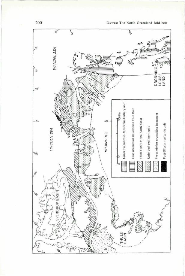
Excluding the Inland Ice, which forms a large percentage of the total areaof northern Greenland, six major geological units can be recognised north of76°N (see fig. 1). These units, which are considered satisfactory divisionsfor the descriptive purposes of this paper, are given below.
(1) Precambrian crystalline basement outcrops mainly in western NorthGreenland in the Thule - Inglefield Land area as well as further to the northand within the fold belt of East Greenland. In the Thule - Inglefield Land areaa variety of gneisses, supracrustal rocks and basic intrusive rocks are knownto occur (see Schei, 1903, 1904; Bugge, 1910; Holtedahl, 1917; Koch, 1920,1933; Callisen, 1929; Davies, 1954; Clebsch, 1954, 1956; Cowie, 1961b;Davies, Krinsley & Nicol, 1963; Fernald & Horowitz, 1954, 1964; Bendix-
15«
200 DAWES: The North Greenland fold belt
Bulletin of the Geological Society of Denmark, vol. 20 [1971] 201
Almgreen, Fristrup & Nichols, 1967), but as yet little is known about thesmall area of basement which outcrops to the north in southern Wulff Landat the head of Victoria Fjord (see Haller, 1961a, p. 156; Koch, 1961, .p. 149; Haller & Kulp, 1962, p. 17 and p. 227 this paper). The basementof western North Greenland is considered to be a continuation of the Nag-ssugtoqidian (Hudsonian) orogenic complex of West Greenland.
According to Koch (1920, p. 28) Ejnar Mikkelsen saw basement gneissaround the head of Danmark Fjord in eastern North Greenland but this ob-servation has not yet been confirmed (see also Nielsen, 1941, p. 26). Inparts of Dronning Louise Land in East Greenland crystalline basementrocks are exposed but some of these occurrences have been affected byCarolinidian and Caledonian disturbances (see Peacock, 1956, 1958; Haller1956, 1961a, 1961b).
A review of the main features of the basement rocks in North and EastGreenland has been given by Berthelsen & Noe-Nygaard (1965).
(2) Unfolded sediment unit of Proterozoic and Palaeozoic rocks which formsa broad belt from the west to the east coast. Koch (1925) referred to thisunit as "the great sediment plain". In the Thule - Inglefield Land area, inVictoria Fjord and in Dronning Louise Land the rocks of this unit overliewith angular unconformity the crystalline basement. In Peary Land andeastern North Greenland the base of the succession is not seen.
(3) Folded unit of the north coast which trends approximately E-W andis bordered to the south by unit (2). This zone is 600 km long and reachesover 100 km in its widest part in northern Peary Land. Cambrian,Ordovician and Silurian rocks have been now identified in the zone andthe sediments vary in metamorphic grade from unmetamorphosed in thesouth to chlorite-, muscovite-, biotite-, garnet-, staurolite-, cordierite- andandalusite-bearing schistose rocks in the north.
(4) Caledonian fold belt of East Greenland which forms an orogenic zonetrending parallel to the east coast. The northernmost structures of the zoneoccur in Kronprins Christian Land (see Nielsen, 1941; Fränkl, 1954, 1955a,1956; Haller, 1961a, 1961b, 1970). The thick sediments of unit (2) occupythe foreland and flank the northern part of the fold belt on the west.
(5) Upper Palaeozoic, Mesozoic-Tertiary sediment unit which occurs as out-liers in eastern Peary Land and in areas to the south bordering the WandelSea. The sediments unconformably overlie the rocks of units (3) and(4) and the unfolded rocks of unit (2).
Fig. 1. Map to show the main geological units of Greenland north of 76° N and theircounterparts in adjacent Ellesmere Island.
202 DAWES: The North Greenland fold belt
(6) Post-Silurian volcanic unit of lavas and tuffs of probable Mesozoic-Tertiary age outcrops on the north coast to the west of Sands Fjord occu-pying an area of about 250 km2.
The context of the paper precludes further discussion of units (1) and(4). The boundary between units (2) and (3) is transitional with unit (2)being arbitrarily limited northwards at the first appearance of small-scalefolds. The sediments of the unfolded unit are in part affected by broad folds(see plate 3).
Outline of geological work up to 1965
The earliest geological investigations in North Greenland were inciden-tal observations carried out by expeditions whose main aims were geograph-ical discovery and exploration, and the conquest of the North Pole. Henceas the Smith Sound route was gradually penetrated during the 19th century,the presence in the Thule area of crystalline basement overlain by thick un-fossiliferous deposits (the Thule Group), and the presence farther north ofunfolded fossiliferous Palaeozoic sediments, became known (see Koch, 1920,for references to early workers). By the turn of the century, when the landadjacent to the Robeson Channel had been visited by the expeditions ledby C. F. Hall (Davis, 1876; Bessils, 1879), G. S. Nares, 1875-76 (Nares,1878, Feilden & De Ranee, 1878; De Ranee & Feilden 1878; Etheridge,1878) and A. W. Greely, 1881-84 (Greely, 1886), and the northernmostpart of the Greenland coast had been discovered in 1900 by R. E. Peary(Peary, 1907), it was known that in the area of Hall Land and NyeboeLand folded sandstones, shales and slates occurred as a zone along thenorth coast while to the south towards the Inland Ice thick unfolded Palae-ozoic carbonate rocks existed.
By 1912, when the 1st Thule Expedition led by Knud Rasmussen crossedthe Inland Ice from Thule and reported large areas of thick flat-lying sand-stones with basic rock intercalations in southern Peary Land around Inde-pendence Fjord (see Rasmussen, 1915; Freuchen, 1915; Bøggild, 1915;Koch, 1920), a two-fold division into northern folded, and southern unfoldedrocks was apparent in eastern North Greenland. Earlier Peary (1898, vol. 1,p. 335) had noted the flat-lying sandstones around Independence Fjord butfailed to comment on them. The folded rocks to the north had been dis-covered during the Danmark Expedition 1906-08 by I. P. Koch and A. Ber-telsen who collected metamorphosed sediments and igneous rocks aroundFrederick E. Hyde Fjord (I. P. Koch, 1916; Bøggild, 1917; Ellitsgaard-Rasmussen, 1955). Ejnar Mikkelsen (1922) also made some scattered ob-
Bulletin of the Geological Society of Denmark, vol. 20 [1971] 203
servations in Kronprins Christian Land and the Danmark Fjord area duringthe Alabama Expedition, 1909-1912.
Such was the scarce geological knowledge of North Greenland when LaugeKoch started his work, first as a member of Knud Rasmussen's 2nd ThuleExpedition 1916-18, and later as leader of the Bicentenary Jubilee Expe-dition 1920-23 (see Rasmussen, 1927; Koch 1926b). Results of Koch'ssledge journeys were enormous both from the geological and glaciological,as well as from the cartographical and physiographical sides. Koch was ableto draw up the first geological map of North Greenland (Koch, 1920, 1925)as well as more detailed maps of the Thule area and Prudhoe Land (Koch,1926a), Inglefield Land (Koch, 1933) and southern Washington Land(Koch, 1929b). Complete colour maps of the rest of Washington Land, theNorth Greenland fold belt and the Thule area, although printed, were neveractually published. From the large quantities of collected fossil material whichwas described in detail by others (see Troedsson, 1926, 1928; Teichert, 1934;C. Poulsen, 1927, 1934, 1941, 1943), Koch was able to construct a strati-graphy for western North Greenland, recognising some 20 formations of Pre-cambrian to Upper Silurian ages (Koch, 1929a). He also gave the fürst tectonicdetails about "the folded mountain chain of North Greenland" (Koch, 1920,p. 62, 1923a, 1925, 1929a). Fossils collected in Washington Land by God-fred Hansen during the 3rd Thule Expedition 1919-20 were described byTeichert (1937).
During the Danish Northeast Greenland Expedition 1938-39, led byEigil Knuth and Ebbe Munck, Eigil Nielsen (1941) reached north of 81°on the east coast of Greenland and made geological observations in Kron-prins Christian Land. Frebold (1950) and Dunbar et al. (1962) described thefossils collected.
Nothing was added to Koch's observations on the folded rocks of NorthGreenland until members of the Danish Peary Land Expedition 1947-50led by Eigil Knuth visited Peary Land. Troelsen (1949b, 1950a, 1951)provided some information from the folded rocks in eastern Peary Landbut the main contribution came in 1950 when Ellitsgaard-Rasmussen (1950,1955) investigated a section across the fold belt in western Peary Land.In 1953, Erdhart Fränkl and Fritz Müller made another traverse of thefolded rocks across northern Peary Land from Frigg Fjord to Kap MorrisJesup during Lauge Koch's East Greenland Expedition 1947-54 (Fränkl,1955b, 1955c). The only other field work on the folded rocks carried outbefore 1965 was scattered observations made by Bill Davies during Quater-nary studies (W. E. Davies, pers. comm.; Davies, Needleman & Klick, 1959;Davies & Krinsley, 1961).
Since Lauge Koch's investigations, the unfolded rocks of the south havereceived considerably more treatment than the folded rocks. Munck (1941),
204 DAWES: The North Greenland fold belt
Troelsen (1940, 1950b), Kurtz & Wales (1951), Davies, Krinsley & Nicol(1963) and Fernald & Horowitz (1954, 1964) have described the unfoldedsediments in the Thule area; Troelsen (1940, 1950b) and Cowie (1961b)have worked on the unfolded Palaeozoic sediments in Inglefield Land, andTroelsen also visited Washington Land. The Cambrian trilobites collectedby Troelsen in Inglefield Land have been described by V. Poulsen (1964).To the east, Troelsen (1949a, 1950a, 1956a) and Adams & Cowie (1953)worked on the Proterozoic and Palaeozoic rocks in the Jørgen BrønlundFjord and Danmark Fjord areas respectively.
Geological field work since 1965
In 1965 and 1966 GGU carried out field work in the western part of thefold belt during the helicopter and fixed-wing supported Operation GrantLand (see Christie, 1966, 1967a). In 1965 J. H. Allaart and the authorworked in Hall Land on both folded and unfolded rocks and examined thetype localities of Koch's Cape Tyson, Offley Island and Polaris HarbourFormations (Allaart, 1965, 1966). In the following summer the author andSteen Skytte continued the work to the north-east in Nyeboe Land, Hendrik0 and Wulff Land (Dawes, 1966, 1967) and B. S. Norford of the Geo-logical Survey of Canada made biostratigraphical studies on the unfoldedSilurian and examined the type locality of Koch's Cape Schuchert Forma-tion (Norford, 1967).
In 1966 and 1968 Hans Jepsen, as a member of Eigil Knuth's 4th and5th Peary Land Expeditions, studied the stratigraphy and basic intrusivesof the unfolded rocks in southern Peary Land (Jepsen, 1966, 1969a, 1969b,in press) and in 1969 the author and N. J. Soper, as members of the JointServices Expedition led by J. D. C. Peacock, spent four months on the foldedrocks of the Roosevelt Fjelde in north Peary Land (Dawes & Soper, 1970;Soper & Dawes, 1970; Peacock, 1970). In addition, observations have beenmade by the author during low-level reconnaissance flights over areas inNorth Greenland which have not been studied on the ground.
1969 also saw the first commercial enterprise in Greenland north of theInland Ice, when Ponderay Polar Ltd undertook reconnaissance work onthe unfolded rocks, as well as studies on the basement of the Thule region.
Unfolded sediment unit
Structure
A number of structural-stratigraphical divisions can be recognised within thisunit. Of these the North Greenland geosyncline covers the largest area; the
Bulletin of the Geological Society of Denmark, vol. 20 [1971] 205
southern shelf zone of this geosyncline extends eastwards from InglefieldLand north of, and partly hidden by, the Inland Ice, into southern PearyLand. The sediments of the Thule - Prudhoe Land area are not consideredpart of this geosyncline but of the Thule Basin (see Koch, 1929a; Kerr,1967a) which Koch (op. cit. p. 271) originally recognised as a sedimentarybasin structurally distinct from the main geosyncline.
The Proterozoic to Silurian sediments of the unfolded unit are charac-terised by having a simple tectonic pattern. The sediments of the Thule Basinare preserved in down-faulted or tilted areas and are for the most partshallow-dipping. Broad anticlines and synclines exist and Davies et al. (1963)have described local folds with limbs dipping as much as 45°. Such struc-tures appear to be due to fault tectonics.
The belt of sediments to the north stretching from Inglefield Land toPeary Land in the east is characterised by a shallow but persistent nor-therly dip so that successively younger rocks outcrop to the north (seeplate 3). The average dip is below 5° but locally steeper dips occur. To-wards the folded unit in the north, the uniform northerly dip no longer pre-vails and a zone characterised by broad flexures exists. These unfolded andslightly folded sediments do not strictly form the foreland of the North Green-land fold belt, since the main direction of overturning in the folded unit istowards the north away from the unfolded sediment unit (see p. 218).
In the east in the Hagen Fjord - Danmark Fjord area, the northerly dipof the unfolded sediment unit changes to an easterly one and the rocksform the foreland of the East Greenland fold belt (Adams & Cowie, 1953;Frank!, 1956). In this area Frankl (1956) recognised a NW structural fea-ture of regional extent - the "Hagen Fjord Geanticline" - which separatesthe easterly dipping sediments of the "Danmark Fjord Basin" from thenortherly dipping sediments of the "South Peary Land Basin." This latterfeature which Fränkl (op. cit., p. 11) describes as "a shallow basin lyingin front of the geosyncline", corresponds to the southern part of the NorthGreenland geosyncline as recognised in this paper.
Proterozoic to Cambrian sediments
Considerable discussion has taken place about the age and stratigraphicalrelations of the oldest sediments in North Greenland which outcrop in abroad arc from the Thule area to eastern North Greenland. No clear datumline is evident over the whole area limiting the base of the Palaeozoicsediments and it is now known that the previously assumed pre-PalaeozoicThule Group (Koch, 1929a; Troelsen, 1949a; 1950b) contains rocks whichvary from Proterozoic to Cambrian in age. A restricted use of Thule
206 DAWES: The North Greenland fold belt
Group to describe only the succession of the Thule area is favoured (seebelow, p. 208).
Rocks which have been referred to the Thule Group are known in somedetail from four main areas (see plate 5).
Thule area
The Thule Group in its type locality is preserved in down-faulted areas whereit overlies with angular unconformity the crystalline basement. The exposedsuccession is over 2300 m thick. Davies et al. (1963), adopting Kurtz &Wales' (1951) original tripartite division, have described the three for-mations: a lower Wolstenholme Formation (490 m) of sandstone and quart-zite, the Dundas Formation (790 m) of black shale with dolomite, sand-stone and basic igneous sills, and an upper Narssårssuk Formation (1040 m)composed of dolomite, siltstone and sandstone. The top of the succession isnot seen and no tillite or diagnostic fossils have been recognised.
Inglef ield Land
The total thickness of sediments ascribed by Troelsen (1950b) to the Eo-cambrian Thule Group in Inglef ield Land is only 190 m (see also Cowie,1961b). Three units are recognised. The lower Rensselaer Bay Sandstone(140 m) overlies the crystalline basement with angular unconformity andis overlain by the Cape Leiper Dolomite (40 m) and the Cape IngersoliDolomite (10 m). The fossiliferous Lower Cambrian Wulff River Forma-tion limits this succession upwards. Up to now no fossils have been col-lected from this 190 m succession but by correlation with the rocks ofEllesmere Island (see Kerr, 1967a, 1967b; Christie, 1967b; also below, p.208), the 190 m succession is considered here as Lower Cambrian in age.
Southern Peary Land
Koch's initial observations (Koch, 1923a, 1925, 1929a) have been addedto by Troelsen (1949a, 1950a, 1956a) and recently by Jepsen (1966,1969a, 1969b, in press). The exposed succession in southern Peary Landis about 1750 m thick and divisible by Jepsen (1969b, in press) into alower unit of sandstones (1000 m+) veined by basic sills and dykes (theInuiteq Sø Formation), overlain unconformably by the Morænesø Forma-tion (117 m) containing the tillite and Cryptozoon dolomites mentioned byTroelsen (1949a), the Portfjeld Formation of dolomite (206 m), and theclastic Buen Formation (425 m). Erosional unconformities separate the
Bulletin of the Geological Society of Denmark, vol. 20 [1971] 207
Portfjeld Formation from the Morænesø Formation, and the Buen Formationfrom the overlying Lower Cambrian Brønlund Fjord Dolomite. The base ofthe succession is not exposed. Troelsen (1949a) regarded the rocks now in-cluded in Jepsen's Morænesø, Portfjeld and Buen Formations as Eocani-brian in age. The Buen Formation is now known to bz Cambrian in age(see below, p. 208).
Danmark Fjord area
In the inner part of Danmark Fjord to the south-east of Peary Land, Adams& Cowie (1953) have described a succession over 1000 m thick. Thebase is not seen and no tillite has been recognised. The succession is divis-ible into a lower unit of Norsemandal Sandstone which is traversed by basicigneous rocks, and an upper unit of Campanuladal Sandstones and Lime-stones and the Fyns Sø Dolomite. The overlying Kap Holbæk Sandstoneis considered by Cowie (1961b) to be of Lower Cambrian age (see below,p. 210).
Discussion, and age of the Thule Group
Koch (1929a, 1929b, 1933) gave the name Thule Formation to the thickunfossiliferous sediments in the Thule area which overlie the crystalline base-ment with angular unconformity and which were considered by him to beof Late Algonkian age. He also regarded a much thinner succession onInglefield Land underlying the fossiliferous Lower Cambrian rocks as partof the Thule Formation, as well as the large areas of flat-lying unfossili-ferous sediments in southern Heilprin Land, Vildtland, I. C. ChristensenLand, Valdemar Glückstadt Land and Kronprins Christian Land (Koch,1929a, p. 221). Troelsen (1949a, 1950b) referred to the formation as theThule Group and, in studying rocks on the Canadian side of the Kane Basinin Bache Peninsula, introduced the name to cover the lower part of thesuccession there. Troelsen (1949a) also included within the Thule Groupthe sediments of Jørgen Brønlund Fjord below the Brønlund Fjord Dolomite,sediments which Koch (1923a, 1925, 1929a, 1935a) had referred to thePalaeozoic. Troelsen (1949a, 1950b) preferred to describe the sediments ofthe Thule Group as Eocambrian since the rocks were said to be separatedfrom the overlying fossiliferous Cambrian by no more than a simple erosionalunconformity. The flat-lying sandstones of southern Peary Land, Vildtlandand the area south of Independence Fjord, considered as part of the ThuleFormation by Koch (1929a), were referred to as Late Precambrian byTroelsen (1956a) and not as part of the Thule Group.
208 DAWES: The North Greenland fold belt
Troelsen (1950b) showed no hesitation in referring the Bache Peninsulasuccession in Canada to the Thule Group, and he confidently carried theGreenland formational names over to Canada. Recent finds of Cambrianfossils on the Canadian side of the Kane Basin, in rocks which can apparentlybe correlated with the succession in the Bache Peninsula and thus with theInglefield Land succession (Kerr, 1967b, p. 8), lead to the conclusionthat parts of the Thule Group in Greenland are of Cambrian age. By infer-ence the thin succession in southern Washington Land which was includedby Koch (1929b, p. 7) in the Thule Formation and which is correlatablewith the dolomites of the Inglefield Land succession also becomes of Cam-brian age. Furthermore, J. Stuart Smith (pers. comm., J. C. Sproule andAssociates) and H. F. Jepsen (pers. comm., in press) report the presenceof olenellid trilobites in the fissile shales at the top of the Buen Formationin southern Peary Land, rocks previously regarded either as Eocambrian(Troelsen, 1949a, 1956a) or tentatively as Lower Cambrian (Cowie, 1961b).These fossil finds prove that the Buen Formation, composed of 425 m ofcyclic sedimented sandstones and shales, is of Cambrian age. It becomesalso quite possible that the underlying Portfjeld Formation is also of Cam-brian age. The nature of the boundary between the Buen Formation and thePortfjeld Formation has not been observed (Jepsen, 1969b, in press).
The succession in the Thule area contrasts markedly with that in Ingle-field Land and the sediments appear to be the products of differentenvironments and sedimentary basins. The sediments in each area may wellbe of completely different age. For this reason, and because the rocks of theThule area also show little similarity to those of southern Peary, Land, theauthor favours the restriction of the name Thule Group in Greenland (Troel-sen, 1949a, 1950b) to Koch's type locality—the Thule area. Christie (1967b)and Kerr (1967a, 1967b) have already refrained from using the name tocover the Bache Peninsula and Inglefield Land successions.
This restricted use of Thule Group is in contrast to the usage of Haller(1961b, 1970) who extends the Thule Group to cover certain Precambriansediments in East Greenland. Haller bases his Thule Group on the ThuleFormation of Koch (1929a), without regard to Troelsen's (1949a, 1950b)original Thule Group. Since Koch's supposed Precambrian Thule Formationin western North Greenland is now known to be in part Cambrian in age,and since the Thule Group in the type locality could in part be of Palae-ozoic age, extension of the name Thule Group specifically to cover the pre-Carolinidian sediments of East Greenland (Haller, 1970, p. 48) implies thatthe sediments of the Thule Group in the Thule area are also part of thepre-Carolinidian cycle. The age of the Thule Group of the Thule area isunknown. Theoretically it may be wholly or in part Proterozoic, Eocambrianor Palaeozoic (Cambrian). No diagnostic fossils have as yet been discovered
Bulletin of the Geological Society of Denmark, vol. 20 [1971] 209
and no isotopic age determinations are available at the time of writing. Theapparent continuation of outcrops from the Thule - Prudhoe Land area intoInglefield Land (see plate 3) suggests that at least part of the sedimentsin the Thule Basin are of Cambrian age.
Correlation
In North Greenland correlations have bsen made between successions fromwidely-spaced areas, and the Thule Group of the Thule area has been corre-lated with the thin succession in Inglefield Land, as well as with successionsas distant as 1000 km in eastern North Greenland (see Adams &Cowie, 1953;Cowie, 1961b; Davies et al. 1963; Berthelsen & Noe-Nygaard, 1965). Inthe light of the recent discoveries some of these correlations are no longertenable. The correlation of the Thule Group of the Thule area with thepre-Carolinidian sediments of East Greenland (Haller, 1970) has been men-tioned above.
Since the Inglefield Land succession now appears to be Cambrian, anycorrelations between that succession and the very much thicker sedimentsof the Thule area (which, as explained, are uncertain), now carry an ageconnotation. Hence if the previously proposed correlations are at allcorrect (e.g. Davies et al., 1963; Berthelsen & Noe-Nygaard, 1965) thenall or much of the Thule Group of the Thule area is of Cambrian age,for which there is little direct evidence. Furthermore, the correlation of theRensselaer Bay Sandstone of Inglefield Land with the oldest sandstonesof southern Peary Land (Jepsen's Inuiteq Sø Formation) and the Norseman-dal Sandstones of the Danmark Fjord area (Adams & Cowie, 1953; Cowié,1961b) can no longer be upheld. Isotopic age determinations indicate thatthe Inuiteq Sø Formation is at least 1000 m.y. old (see p. 228).
On the other hand the evidence for a thicker Cambrian succession inboth Inglefield Land and Peary Land allows closer comparison of the strati-graphies of these two areas, although a difficulty remains with respect tothe correlation of the Thule Group, sensu stricto, with the sediments ofsouthern Peary Land and the Danmark Fjord area. The Peary Land andthe Danmark Fjord successions have some clear similarities which allowtentative correlation. Although no tillite has been recognised in the lattersuccession, a correlation is suggested since in both areas a two-fold divisioninto a unit containing basic intrusions and an overlying unit lacking suchintrusions can be made (see Adams & Cowie, 1953; Cowie, 1961b). InPeary Land, Jepsen (1969a) has clearly demonstrated the discordance betweenthe lower and upper units, but while no angular discordance was observedby Adams & Cowie (1953, p. 10) from Danmark Fjord, those authors putforward with confidence the two-fold division and regard the upper unit as
210 DAWES: The North Greenland fold belt
post-dating the basic intrusions in the lower. Whether this two-fold divisioncan be achieved in the Thule area, where part of the succession is typifiedby conspicuous basic sills, is not as yet known. Davies (Davies et al. 1963,p. 45) suggests that the discordance which separates the Dundas Forma-tion containing the conspicuous basic sills from the overlying NarssårssukFormation is an unconformity although he regards the field evidence asequivocal. The presence in both areas of the basic rocks prompted corre-lation even as early as 1912 (see Koch, 1920, p. 28).
In conclusion it can be stated that the thickness of Cambrian strata inNorth Greenland is greater than earlier thought. As well as the newly-dis-covered Cambrian strata directly overlying the basement in the Kane Basinarea, Cambrian rocks in southern Peary Land have a much thicker extentthan envisaged by Troelsen (1949a, 1956a), and not only the CambrianBuen Formation, but also the Portfjeld Formation, or even rocks lowerdown in the succession there, might be of Cambrian age. Furthermore, partor much of the Danmark Fjord succession between the Kap Holbæk Sand-stone and the Norsemandal Sandstone, and part of the Thule Group in theThule Basin, may well turn out to be Palaeozoic in age.
Palaeozoic sediments
Cambrian, Ordovician and Silurian rocks are represented in the unfoldedunit. The unfolded Devonian suggested initially by Koch (1920, 1923a,1923c) in the Hall Land - Nares Land area was later referred to theSilurian (Koch, 1925, 1929a). No Devonian rocks have been proved andthe youngest pre-orogenic sediments appear to be Upper Wenlockian-LowerLudlovian (C. Poulsen, 1934, p. 45). The Devonian sediments reported byKerr (1967a, p. 503) to occur in Washington Land are probably of olderage (see p. 217). Koch (1929a, 1929b, 1933) and C. Poulsen (1927, 1934,1941, 1943) erected a stratigraphy for western North Greenland whichwas later modified by Troelsen (1950b). The type localities for the forma-tions occur in Inglefield Land, Washington Land and Hall Land. Koch(1929a) and Nielsen (1941) attempted to recognise some of these forma-tions as far east as respectively Peary Land and Kronprins Christian Land.
No Palaeozoic rocks have been identified in the Thule area but in Ingle-field Land a sandstone-carbonate succession of Cambrian age (in part theEocambrian of Troelsen, 1950b, see above, p. 206) and overlying Ordo-vician limestones, rests with angular unconformity on crystalline basement.Elsewhere, as in Peary Land and the Danmark Fjord area, the identifiedPalaeozoic rocks lie on older sediments (see plate 5).
In Washington Land the base of the Palaeozoic strata is not exposed buta rather complete succession of Cambrian, Ordovician and Silurian rocks
Bulletin of the Geological Society of Denmark, vol. 20 [1971] 211
outcrops (Koch, 1929b). In southern Peary Land, Ordovician limestonesand dolomites overlie the Brønlund Fjord Dolomite (Troelsen, 1949a).Northwards these rocks are overlain by Silurian carbonates and elastics. Inthe Danmark Fjord area, the Kap Holbæk Sandstone is overlain by the Cam-brian? Danmark Fjord Dolomite and the Ordovician to Silurian CentrumLimestones (Adams & Cowie, 1953; Cowie, 196la). In the light of thelowering of the base of the Cambrian section in Peary Land (see above,p. 210), part of the succession below the Kap Holbæk Sandstone in the Dan-mark Fjord area (i.e. Fyns Sø Dolomite and part of the CampanuladalSandstones and Limestones) may well be of Cambrian age.
The Palaeozoic stratigraphy in western North Greenland is characterised bya predominance of carbonate rocks in which stratigraphical breaks are appar-ently common. The carbonates vary from massive, hard limestones to well-bedded arenaceous and argillaceous limestones and shales. Limestone con-glomerates are reported to be common (Koch, 1929a). Some sandstone unitsoccur particularly in the Cambrian part of the succession. In the InglefieldLand - Washington Land area the succession reaches over 2000 m in thick-ness. In the Nyeboe Land - Wulff Land area the thickness is probably morethan this but the lowest part of the stratigraphy adjacent to the crystallinebasement is not known in any detail.
A major discovery of the recent field work has been the recognition inthe area between Washington Land and Wulff Land of a Palaeozoic reefcomplex (Allaart, 1965; Norford, 1967). Reefal and off-reefal rocks occurover much of the western part of the unfolded unit and exist as Koch'sCape Schuchert, Offley Island and Cape Tyson Formations. The richly-fos-siliferous underlying Ordovician in the Nyeboe Land - Wulff Land areais also reefal in character but elsewhere, for example in Washington Land,the Upper Ordovician Cape Calhoun Formation of Koch (1929a) and theGonioceras Bay Formation of Troedsson (1926), which have not been re-studied, may not bs reefal in nature.
At Kap Tyson, Koch's Silurian formation of that name is a biohermalbluff about 400 m thick overlying the banded biostromal limestones of theOffley Island Formation (plate 1). This reef development can be tracedeastwards across Hall Land where it forms a ridge of high ground - theHauge Bjerge. Local bioherms exist north of the main reef. The main reefis well exposed on both sides of Newman Bugt as high bluffs and it con-tinues with an east-west strike across Nyeboe Land and into Warming Landand Wulff Land - always tending to form high ground. Another importantaccumulation of limestone reef occurs to the south of the Kap Tyson .reefand is exposed at places on the west coast of Washington Land. This reefbuild-up is less continuous than the Kap Tyson reef, and local biohermsare flanked by darker argillaceous shales. Classic bioherm developments are
212 DAWES: The North Greenland fold belt
Fig. 2. Facies front at the contact of a reef bioherm (left). Platy limestones, and calca-reous and argillaceous shales overlap onto, and grade into, the massive biohermallimestone of the reef. Facies changes in connection with the Kap Tyson reef are abrupt.Height of the section is approximately 100 m. Hauge Bjerge, eastern Hall Land.
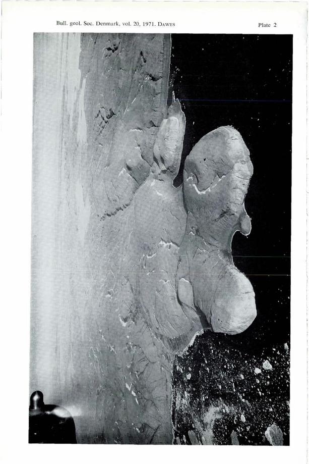
Plate 1Oblique aerial photograph of western Hall Land and the Robeson Channel areaviewed northwards towards the Arctic Ocean. Kap Tyson is the cliff in the centre, withOffley 0 in the centre foreground. Offley 0 and the lower part of Kap Tyson is com-posed of banded biostromal limestones of Koch's (1929a) Offley Island Formation; theupper part of Kap Tyson is a biohermal bluff of the Kap Tyson reef (Koch's Cape Ty-son Formation), which stretches across Hall Land and forms the Hauge Bjerge. Themountains of northern Hall Land and Nyeboe Land, composed of folded, mainly clasticrocks of the Cape Rawson Group, are just visible. Ellesmere Island, with the snow-covered United States Range, is visible to the west of the Robeson Channel. 22. July,1953. Reproduced by permission of the Geodetic Institute, Copenhagen (A316/70). Pho-tograph 546 D-N 11458.
Bulletin of the Geological Society of Denmark, vol. 20 [1971] 213
well seen around Kap Constitution and Kap Independence where the boldcoastal capes are composed of reef knolls, flanked by off-reefal argillaceousand graptolitic shales (plate 2). Norford (1967) reports similar relations of"reefal, off-reefal, and graptolitic fades" at Kap Schuchert further to thenorth in Washington Land.
In the Hall Land - Nyeboe Land area where the northern reef develop-ment has been studied on the ground, the carbonates of the actual reefbioherm grade northwards into a fore-reef argillaceous facies with graptoli-tic shales (Allaart, 1965; Dawes, 1966; Allaart & Dawes, in prep.) Northof this, the calcareous shales and platy limestones give way to a clasticseries composed of alternating sandstone and shale units. Most of these rocksoccur in the folded unit and can be referred to the Cape Rawson Group(see p. 217). To the south of the main bioherm, a back-reef facies of ar-gillaceous calcareous shales occurs and this appears to grade into the bandedlimestones farther south. Lateral facies changes bordering the bioherm canbe very abrupt but on a regional scale the Silurian rock pattern is one ofinterdigitation and intertonguing of biostromal and biohermal carbonates withgraptolitic and argillaceous calcareous shales. In many places overlapping ofargillaceous beds onto reef bioherm can be seen (fig. 2).
No reef complex has as yet been recognised in Peary Land. Neverthelessthere appears to occur in that area, particularly in the Ordovician and Si-lurian, a gradation from predominantly carbonate rocks of the southernshelf into more arenaceous and argillaceous material towards the folded area- a pattern which simulates that of the area between Hall Land and WulffLand.
Following the field work in 1965 and 1966 and the recognition of thereef complex with its complicated lateral facies changes, it became clear
Plate 2Oblique aerial photograph, taken looking south-east, of the western coast of WashingtonLand showing Kap Constitution (left centre) and Kap Independence (right centre). Thelight-coloured coastal capes are reef knolls, the valleys between them are etched out ofoff-reefal argillaceous and graptolitic shales of the same age. These off-reefal rocksform the uniformly dipping strata seen forming the coast on both sides of the biohermdevelopment. Compare with figure 57 in Koch, 1929a (p. 278) which shows Kap Con-stitution viewed from the north, and in which the reef knolls are considered as part ofthe Offley Island Formation and the surrounding graptolitic shales as belonging to theyounger Cape Tyson Formation. Text reference p. 214. 16th July, 1950, Reproduced bypermission of the Geodetic Institute, Copenhagen (A 211/70). Photograph 545 K1-S02258.
16
214 D AWES: The North Greenland fold belt
that Koch's stratigraphy of the Ordovician and Silurian in this part of NorthGreenland needed critical revision (Dawes, 1966). Koch (1929a) de-scribed the Offley Island Formation and the Cape Tyson Formation asboth varying markedly in character. The Offley Island Formation was saidto be "made up of arenaceous limestone and shales, overlain mostly bymassive-bedded, cliff-forming limestone of a light colour and very hard"(Koch, 1929a, .p. 238), while the Cape Tyson Formation was formed ofmassive limestone together with "very fine-grained shales containing grapto-lites interstratified with thin bands of dark limestone" (Koch, 1929a, p. 240).Koch's unpublished colour map of Washington Land clearly shows that hewas able to map out the various rock facies of the Silurian and it becomesapparent that the facies recognised by Koch are the different componentsof a reef complex of regional extent, so that the graptolitic shales are thelateral facies equivalent of the biostromal and biohermal limestones whichas Koch remarks are "cliff-forming".
Koch (1929a, p. 240) also postulated a significant unconformity betweenthe Cape Tyson Formation and the Offley Island Formation and states thatthe latter formation has been "dissected by valleys several hundred metresdeep" which were then filled by the rocks of the Cape Tyson Formation.In Hall Land, where both formations have their type localities, no evidencefor this unconformity was found in 1965 and the irregularities in the reefbluff at Kap Tyson are connected- to the biohermal nature of the lime-stones. Furthermore, those cases found where argillaceous limestones andgraptolitic shales abut against, or overlap onto, the Kap Tyson reef lime-stones, the relationship can be explained as reefal and off-reefal rocks ofsimilar age and is not evidence of an unconformity.
It was in western Washington Land that Koch clearly indicated the natureof this unconformity with "islands" of Offley Island Formation surroundedby graptolitic shales of the Cape Tyson Formation (Koch, 1929a, p. 278,cf. plate 2). The unconformity in this case is interpreted as the irregularupper surface of the bioherm so that the graptolitic shales are the off-reefaldeposits (see also Kerr, 1967a, p. 498). Without having seen more of Koch'slocalities on the ground it would be audacious to comment further, par-ticularly about the relative ages of the individual units making up the Silu-rian. The ages of the reefal and off-reefal deposits depend on the nature andrate of growth of the actual bioherm and factors affecting the depositionof the surrounding off-reefal rocks, none of which are as yet known in anydetail from North Greenland. However, it is clear that rocks referred byKoch (1929a) to the Offley Island Formation and the Cape Tyson Formation(and most probably the Cape Schuchert Formation studied by Norford, 1967)are in places of the same age and a picture of stratigraphical relationshipsemerges which is considerably more complicated than one of formations
Bulletin of the Geological Society of Denmark, vol. 20 [1971] 215
separated by simple unconformities. Thus, since Koch's Offley Island For-mation and Cape Tyson Formation have their type localities in preciselythe same area (see plate 1), the use of two formational names to describedeposits of essentially the same age is misleading. The present author thusextends the Offley Island Formation to include the limestones and associatedrocks of Koch's Cape Tyson Formation, which at Kap Tyson is but theupper part of a limestone reef build-up. As mentioned earlier it is difficultto distinguish rocks of Koch's Cape Tyson Formation from those of theOffley Island Formation away from the type locality (Dawes, 1966, p. 13).On the other hand, the limestones making up Koch's Offley Island Forma-tion form the lower half of the bluff at Kap Tyson, conspicuous tractsin Hall Land and Washington Land, as well as the reef bioherms at KapConstitution (Koch, 1929a, p. 278). The name Kap Tyson is retained todescribe the reef bioherm of the Hall Land - Wulff Land area, a cross-section of which is well exposed at Kap Tyson (plates 1 and 4). The upperSilurian Polaris Harbour Formation, said to consist of coarse sandstonesand to overlie the Cape Tyson Formation limestones in the Hall Land -Wulff Land area (Koch, 1929a, 1961), has already been discreditedand the use of this term should be discontinued (Dawes, 1966).
Kerr (1967a) has drawn similarities between the Palaeozoic reef develop-ments in Greenland and those to the west of the Nares Strait and hassuggested correlation between the Greenland formations with those of Elles-mere Island. Correlation of the Palaeozoic formations across North Green-land must wait until detailed work has been carried out in the ground eastof Wulff Land.
Folded unit of the north coast
Stratigraphy
The stratigraphy of the folded unit is not known in any great detail anduntil recently, the evidence for the age of the folded rocks has been basedon the observation that the Proterozoic to Silurian rocks of the unfoldedunit pass northwards into the folded unit. Apart from the Silurian fossilsreported by Etheridge (1878) from Polaris Bugt and Thank God Harbour,which might have originated from the folded rocks of Hall Land, until1965 the only direct evidence as to the age of the folded beds was Koch'sobservation of folded fossiliferous Silurian in northern Hall Land (Koch,1925, p.. 275; 1929a, p. 280) and Troelsen's (1956a, p. 87) recognitionof olenellidae in the folded Lower Cambrian Schley Fjord Shale in easternPeary Land. Since 1965 Ordovician and Silurian shelly and graptolite faunashave been collected from the folded rocks in Hall Land (Allaart, 1965),
16«
216 DAWES: The North Greenland fold belt
Fig. 3. Sedimentary structures in an alternating sandstone-shale sequence of the CapeRawson Group. Ball-and-pillow structures, due to slumping, characterise the centralsandstone layer; load casts and flame structures are present at the base of the uppersandstone unit. Northern Hall Land.
Cambrian carbonate rocks have been discovered in northern Nyeboe Land(Dawes, 1966; V. Poulsen, 1969), and Ordovician-Silurian graptolite andtrilobite-brachiopod-coral faunas have been discovered in northern PearyLand (Dawes & Soper, 1970; Soper & Dawes, 1970).
To the west of Peary Land, the oldest rocks in the folded unit occurin the northern part of the Nyeboe Land - Wulff Land area. In Wulff Landa succession of pinkish white Cambrian? quartzite, sandstone, and quartziticconglomerate outcrops, and in northern Nyeboe Land a succession ofgrey and yellow limestones and dolomites with alternating dark shales andslates occurs. A mainly agnostid fauna from these limestones prove aMiddle Cambrian age for part of the succession (V. Poulsen, 1969). Theserocks pass into Ordovician carbonates characterised by intraformationalbreccias and conglomerates. Upper Ordovician? dolomite also outcrops onthe north coast of Hall Land (Allaart, 1965).
The folded Silurian rocks in the Hall Land — Nyeboe Land area arerepresented by a thick clastic sequence of turbidite sandstones and shales
Bulletin of the Geological Society of Denmark, vol. 20 [1971] 217
of low metamorphic grade. These rocks display well-preserved sedimentarystructures, e.g. load casts, flute casts, flame structures, groove casts, slumpstructures, ripple-drift bedding, graded bedding, etc. (fig. 3). In Hall LandAllaart (1965) describes 1000 m of clastic rocks overlying the supposed Up-per Ordovician dolomite. The succession there includes, from base upwards,dark platy limestones with some chert, grey calcareous slates, calcareoussandstone and quartzite, rhythmically bedded sandstones and shales, andmudstones containing intercalated sandstones. Graptolites collected from thetop of this succession suggest an Upper Silurian age for the mudstones.On Hendrik 0, Reef 0 and Castle 0 conglomerate is conspicuous inthe succession, where the clasts are mainly composed of quartzite and chertwith rare crystalline gneiss.
The whole of the folded clastic and argillaceous succession in northernHall Land, Nyeboe Land and Hendrik Ø is considered as part of the CapeRawson Group (Feilden & De Ranee, 1878-, Christie, 1964). Much dis-cussion has taken place about the age of these rocks (see e.g. Koch, 1920,p. 56; Troelsen, 1950b, p. 64). Feilden & De Ranee (1878) gave them apossible Huronian age. Koch (1920, 1921) indicated the rocks as Devonianbut later, after recognising the presence of Silurian elements in the foldedzone (Koch, 1925, 1929a), he considered the folded elastics along thenorth coast of Greenland as "mostly Gotlandian" (Koch, 1935a, p. 617).Christie (1964, p. 22) regards the Cape Rawson Group in north-easternEllesmere Island as Silurian while Kerr (1967a) considers that the groupextends into the Devonian both in Ellesmere Island and in Greenland.For instance, in eastern Ellesmere Island Kerr states that the group is "asold as Late Ordovician in the north to probably Middle Devonian in thesouth" (op. dt., p. 497) while in Washington Land in Greenland he statesthat the group "can be no older than Middle Silurian, and is probablyno older than Early Devonian" (op. cit., p. 503). In North Greenland De-vonian sediments have not yet been proved and in Washington Land thearenaceous and argillaceous rocks referred by Kerr (op. cit.) to the CapeRawson Group are most probably of Silurian age being the lateral equiva-lent of the carbonate rocks of the reef complex (see above, p. 214). Further-more, since the Silurian fossils reported by Allaart (1965) from the CapeRawson Group were collected from the youngest rocks of the succession innorthern Hall Land, the exposed clastic pile in Greenland may not reachDevonian as it apparently does in eastern Ellesmere Island.
A monotonous sequence of quartzite, sandstone and graywacke rocks alter-nating with shales and slates characterise Nansen Land in western PearyLand (Ellitsgaard-Rasmussen, 1950, 1955). The age of this succession isunknown but the rocks are similar to the elastics of the Cape RawsonGroup to the west, which are on approximately the same strike.
218 DAWES: The North Greenland fold belt
In northern Peary Land, Fränkl (1955b) has described a succession ofmetasediments composed of marbles, schists, phyllites and slates separatedby the Polkorridor Series from a southern succession of unmetamorphosedsandstones, shales and mudstones. Despite the lack of faunal evidence Fränklgave the units, which together reach a thickness of 3000 m, tentative agesfrom Precambrian to Upper Silurian. The rocks seen by Fränkl were re-studied in 1969 and a revised stratigraphy has been suggested (Soper &Dawes, 1970). Fränkl's unit names have been retained as far as possiblebut some are discarded, especially in those cases where a revised structuralinterpretation suggests a single mappable, but highly folded, unit as beingequivalent to two or more of Fränkl's stratigraphic-structural units.
The Polkorridor Series of Fränkl was found to be a thick arenaceousunit composed of brown- to buff-weathering, well-bedded psammitic rocksand intercalated shales with grit and conglomerate horizons. The rocks forma turbidite sequence and can be traced from eastern Peary Land into theRoosevelt Fjelde, so that the unit strikes towards the clastic rocks of westernPeary Land investigated by Ellitsgaard-Rasmussen (1955).
In the area around Frederick E. Hyde Fjord which was not studied byFränkl, a succession of rhythmically bedded calcareous sandstones, withsiltstone and shale units, occurs, in which there are conspicuous units ofyellow-weathering limestones. These frequently contain intraformational brec-cias and conglomerates. Some dark grey to black chert units and white tocream quartzites occur in the succession. The Ordovician-Silurian fossils fromnorthern Peary Land mentioned above were collected from this succession.
Structure
Lauge Koch, in his initial investigations of the folded rocks, was able toshow that the axes of the main structures were approximately east-weststriking and parallel to the boundary between folded and unfolded units(Koch, 1920). He also noted that the most severely deformed rocks with thehighest metamorphic grade occurred in northern Peary Land (1923a, p. 193;1925, p. 275).
The style of folding in western Peary Land was shown by Ellitsgaard-Rasmussen (1950, 1955) to be characterised by asymmetrical folds withsoutherly-dipping axial planes. He concluded (1955, p. 53) that "the foldingwas caused by a combination of forces with a northward direction" and that"the south foreland, the existence of which has hitherto been assumed, i.e.the unfolded deposits in North Greenland, seems tectonically to have acted ashinterland". This structural pattern was confirmed to be typical of northernPeary Land by Fränkl (1955b, 1955c, 1956) who described folds over-turned to the north, in places isoclinal and recumbent, and who interpreted
Bulletin of the Geological Society of Denmark, vol. 20 [1971] 219
the mountains of northern Peary Land, which reach almost 2000 m inheight, in terms of alpinotype structures with northward directed nappes andintense overthrusting. Koch (1923a, p. 193) had suggested earlier that over-thrusting occurred in Peary Land. Haller (1961a) has also regarded northernPeary Land as characterised by intense superficial thrusting and has sug-gested an east-north-east thrust system as typical of the tectonic patternbetween Nansen Land and eastern Peary Land (Haller & Kulp, 1962,p. 32).
The presence of such important overthrusts and of associated nappes ofalpine dimensions in northern Peary Land is not confirmed by recent fieldwork, and the regional structural pattern can be explained without recourseto nappe and thrust tectonics (Soper & Dawes, 1970; Dawes & Soper, 1970).In some localities where thrust contacts have been said to exist, the disruptedcontact zone can be explained by complications due to the interference ofdifferent fold phases; elsewhere the stratigraphy is continuous and only brokenby minor dislocations and high-angled faults. Earlier Ellitsgaard-Rasmus-sen (1955, p. 54), commenting on Koch's suggestion about possible over-thrusting in Peary land, also concluded that "the structure does not seem tooffer any foundation for an assumed overthrusting."
The contact between the folded unit and the unfolded rocks to the southis not a sharp, clear-cut boundary marked by thrusting as is the case forexample in the Caledonian fold belt in northern East Greenland, but rathera gradual passage from unfolded to folded rocks. This passage is well seenin Nyeboe Land where, from south to north, gently folded beds (correspondingto the northern fore-reef argillaceous fades of the unfoldede carbonate reef(see p. 213), pass into a zone characterised by monoclines, then asymme-trical folds and further north into isoclinal folds overturned to the north(Dawes, 1966, p. 13). The same pattern-exists" in Hall Land (Allaart,1965, p. 10) and in western Peary Land (Ellitsgaard-Rasmussen, 1955,p. 9) and appears to continue in the area of Frederick E. Hyde Fjord. How-ever, in places south of this fjord, this fold geometry is reversed and thefirst folds north of the gently folded and unfolded rocks are southward fac-ing with northerly-dipping axial planes. Such structures directed towards theplatform area of the south are the result of forces different from thoseresponsible for the northward-facing folds present elsewhere.
In northern Peary Land at least three phases of deformation have producedvisible folds, the majority of which are overturned towards the north (Soper& Dawes, 1970). The first two deformations produced coaxial folds whichbecome isoclinal in the north. A main southerly-dipping cleavage (S2) par-allel to the axial planes of the F2 folds post-dates an early cleavage (St)and a set of coaxial folds which in the south have axial planes of variabledip. Some southward-facing folds pre-date S2. In places S2 is folded into
220 DAWES: The North Greenland fold belt
Fig. 4. Thrust contact on the eastern side of Benedict Fjord between the volcanics ofthe Kap Washington Group (dark) and the overlying metasedimentary phyllites. Themetasediments have been thrust from the south over the volcanics, and mylonites arewell developed in the thrust zone. The dark layers in the metasediments are basicigneous sills which show the effects of Tertiary tectonism. Height of the exposed sectionon the right is approximately 400 m. 16th May, 1969.
F3 kink-bands and even larger structures. The cleavage-bedding relationsare complicated and are not everywhere easily fitted into the regional pattern offolding. The same complex relations also occur in the western part of thefold belt (Allaart & Dawes, in prep.) Despite the polyphase deforma-tional history of the folded rocks, the regional strike is relatively simple.The folds are coaxial and few variations from an east-west regional tec-tonic grain are present. In the area north of the head of Frederick E. HydeFjord, some north-west and even north-south trends occur and these arepresumed to be due to the interference of the deformation phases mentionedabove.
Both high-angled faults and thrust-faults, as well as low-angled thrusts,occur in the western part of the fold belt and in Peary Land. Some of theseappear to have developed in connection with the folding and have mainlysouthward-dipping dislocation planes while others are clearly later and bearno genetical relationship to the fold structures which they truncate. A con-spicuous thrust occurs in northern Hall Land where the direction of thetransport appears to have been from the south (cf. Haller & Kulp, 1962,
Bulletin of the Geological Society of Denmark, vol. 20 [1971] 221
p. 33). In northern Nyeboe Land a set of high-angled thrust-faults occursparallel to the strike of the folded rocks. These are mainly steeply in-clined to the south but some have vertical or steeply northward-dippingfault planes. The main thrust-fault, of the set separates the Cape RawsonGroup elastics of the south from the Cambro-Ordovician carbonate sequenceof the northern coast. The outcrop of these carbonate rocks could be dueto the upthrust of the northerly area. High-angled thrust-faults with bothsouthward- and northward-dipping fault planes have been described fromwestern Peary Land (Ellitsgaard-Rasmussen, 1950, 1955).
In the extreme north of Peary Land a conspicuous thrust occurs separat-ing the Kap Washington Group of volcanics from the metasediments ofthe south (see fig. 4). The metasediments have been thrust from the southover the volcanics along a shallowly-dipping thrust plane, along which mylo-nites are developed. This thrust is of Tertiary age (see p. 229). Other maineast-west striking faults in Peary Land are also of Tertiary age, two of which,the Kap Bridgman Fault and the Harder Fjord Fault border the moun-tains of northern Peary Land (Roosevelt Fjelde) which are preserved as atectonic uplifted block (see Haller & Kulp, 1962, p. 32).
Metamorphism
The effects of metamorphism increase from south to north in the foldedunit (Koch, 1923a, 1925; Ellitsgaard-Rasmussen, 1950, 1955; Fränkl,1955b). In the area of Frederick E. Hyde Fjord the visible changes in thesediments are due mainly to dynamic metamorphism (cleavage, crushing,slickensides, etc.). Only in a few places has recrystallisation and the produc-tion of a strong cleavage resulted in partial obliteration of the primary struc-tures of the sediments. Similar metamorphic conditions exist in Nansen Land(Ellitsgaard-Rasmussen, 1955). Towards the north increased dynamic me-tamorphic effects and the appearance of metamorphic minerals occur, sothat in places the rocks of the central and northern part of the RooseveltFjelde are chlorite-, chloritoid- and muscovite-bearing slates and phyllites.On the north coast at Kap Morris Jesup garnet schists outcrop (Koch, 1923a,1925; Fränkl, 1955b) and along the coast to the west, pelitic and semi-pelitic schists and phyllites and associated psammitic rocks contain chlor-ite, biotite, muscovite, andalusite, cordierite, sillimanite, garnet and stau-rolite. Calc-silicate units contain garnet and amphibole. The rocks are poly-metamorphic and the metamorphic isograds in northern Peary Land appearnot to be completely parallel to the lithostratigraphical boundaries.
Quartz veins and streaks are common in the rocks of northern PearyLand and they have been formed at various times throughout the defor-mational history. Only in a few cases does feldspar join quartz in these veins.
222 DAWES: The North Greenland fold belt
Quartz and cälcite veins are common in western Peary Land (Ellitsgaard-Ramusssen, 1955).
In the western part of the folded unit the metamorphic state of the rockscorresponds to that in the Frederick E. Hyde Fjord region of Peary Land.Effects of dynamic metamorphism are common and the argillaceous com-ponents of the clastic rocks in northern Hall Land and Nyeboe Land canbe highly cleaved and in places the rocks are fissile slates. In the northernpart of Nyeboe Land the sandstones are clearly indurated and in placeshave a sheen due to the development of mica (Dawes, 1966).
It can be assumed that metamorphism accompanied the main deforma-tion and that the sediments in the north of the folded unit developedPalaeozoic metamorphic mineral assemblages. Folded biotite and muscovitein some of the pelitic rocks bear witness to this metamorphism. However,the four isotopic age determinations obtained so far from folded schistoserocks (see p. 229) have given Cretaceous-Tertiary ages and it is clear thatthe Palaeozoic assemblages have been "overprinted" to a certain extent.It is considered likely that a Laramidian regional reheating of part of thefold belt occurred producing (re)crystallisation of mineral assemblages inalready folded and metamorphic rocks. The presence of such minerals ascordierite, andalusite, staurolite, sillimanite and muscovite suggests a regionalmetamorphism of Abukuma-type.
Upper Palaeozoic, Mesozoic-Tertiary sediment unit
Distribution and structure
Carboniferous, Permian, Triassic and Cretaceous-Tertiary sediments form anumber of outliers in eastern Peary Land, on the Prinsesse Øer and in thecoastal areas of Kronprins Christian Land, south of the Wandel Sea (seeplate 3). These sediments are not known in any great detail but the large arealextent of the scattered outcrops in North Greenland signifies an importantbasin of deposition. However, the suggestions that Upper Palaeozoic sedi-ments form large areas immediately south of Frederick E. Hyde Fjord (Fränkl1955b, p. 36; Maync, 1961, fig. 1), as well as small exposures north ofthis fjord (Haller & Kulp, 1961, p. 20), are not confirmed by the recentfield work.
The occurrence of Permo-Carboniferous sediments in eastern KronprinsChristian Land has been known since the Danmark Expedition 1906-08(see Nathorst, 1911; Grönwall, 1916). The Carboniferous outcrops in PearyLand were discovered during the Bicentenary Jubilee Expedition 1920-1923(Koch, 1923a, 1925). Later, Nielsen (1940, 1941) and Troelsen (1949b,1950a) examined the successions in Kronprins Christian Land and Peary
Bulletin of the Geological Society of Denmark, vol. 20 [1971] 223
Land respectively and examined Mesozoic-Tertiary rocks as well as theUpper Palaeozoic sections. In Kronprins Christian Land the distribution ofthe Permo-Carboniferous and the Cretaceous-Tertiary beds is reasonablywell known but in eastern Peary Land, the outcrop pattern of the sedimentsis poorly known (see Troelsen, 1956a, pp. 82-83). Little is known about thecontact relationships of the different ages of sediments, or the nature of thestratigraphical breaks within the succession. . . . . . .
Koch (1925, p. 282) recognised that the sediments in eastern Peary Landpost-date the main diastrophism of the folded unit of the north coast, andhe also noted that the Carboniferous strata were in places inclined up to 40°,and that faulting had affected the rocks (Koch, 1929c, p. 93). Troelsen(1950a) observed the actual unconformity between the folded Lower Palae-ozoic sediments and the less disturbed Carboniferous strata and also notedthat the younger cover was affected by faulting and local folding after thedeposition of the Cretaceous-Tertiary sediments. The flexures present inthese cover rocks in Peary Land appear to have a general north-west trendand dips of fold limbs of up to 45° have been recorded in some of thePermian sandstones (W. E. Davies, pers. comm.).
Stratigraphy
In 1921, Koch discovered at Herlufsholm Strand in eastern Peary Land,a sequence of dark shales which passed upwards into limestone and shales,and finally into sandstone and conglomerate. The shales and limestones ofthis succession yielded a Carboniferous fauna of corals, crinoids, brachiopods(Productus, Spirifer) and Fenestella (Koch, 1923a, p. 193; 1925, p. 282;1929c, pp. 93-94). Koch referred this succession, which was described asbeing 700 m thick, to the Upper Carboniferous Mallemuk Mountain For-mation of northern East Greenland (Koch, 1929b, p. 245). Troelsen (1950a)was able to show that the oldest rocks in the succession in eastern PearyLand were marine fusulinid-bearing strata of Pennsylvanian (Triticites) age.
Permian rocks in eastern Peary Land were also noted but not describedby Troelsen but in 1961, W. E. Davies (pers. comm.) identified a greyto brown sandstone sequence which weathers to a brilliant red colour andwhich contains Upper Permian fossils. This sandstone is possibly equivalentto that forming the top of Koch's succession. Dark grey to buff-colouredfossiliferous limestones outcrop to the south of Station Nord. The fauna ofthese limestones (corals, polyzoans, echinoderms, brachiopods) has beenidentified as Permian in age (Christian Poulsen, pers. comm.).
The greater part of the Upper Palaeozoic in North Greenland developedin the marine facies although along the coast of Kronprins Christian Landplant-bearing Lower Carboniferous continental beds occur (Nathorst, 1911;
224 DAWES: The North Greenland fold belt
Nielsen, 1941). These beds, which are mainly sandstones and shales, inplaces with coal units up to half a metre thick, are overlain by a marine sec-tion over 1000 m thick composed of Upper Carboniferous and Lower Per-mian limestone, dolomite, shale and sandstone. Grönwall (1916), Frebold(1950) and Dunbar et al. (1962) have described the fauna of these marinerocks. Coal beds, with dark shales, also outcrop on the Prinsesse Øer.
Troeisen (see Kümmel, 1953) described from Herlufsholm Strand in east-ern Peary Land a 630 m section of Triassic sandstones, marls and shales.The relationship of this succession to Koch's original 700 m section is notknown. Eigil Nielsen identified the lowest 200 m of Troelsen's section asLower Triassic on account of the fish fauna which has clear similarities tothe Scythian fish horizon of Spitsbergen. The upper part of the sectionwas referred by Kümmel (1953) to the Middle Triassic on the basis ofammonites of Anisian age. The Triassic marine sediments of Peary Landshow affinities with the Triassic of Arctic and Cordilleran North America,Spitsbergen and Siberia.
No Jurassic rocks have been recorded from Peary Land or KronprinsChristian Land. Plant-bearing shales and marine beds of Cretaceous-Tertiaryage have been recorded by Troelsen (1950a) from eastern Peary Land, andNielsen (1941) has described a 300 m section of marine sandstones ofsimilar age from Nakkehoved to the east of Station Nord. The relationshipbetween these rocks and the Triassic deposits of Peary Land is not known.
Post-Silurian volcanic unit
A volcanic suite of lavas and tuffs outcrops on the north coast from theeast side of Benedict Fjord to De Long Fjord in the west. Koch (1920,p. 74) initially indicated areas of "eruptive" rocks in the area of De LongFjord and, after revisiting the coast in 1921, mentioned the presence ofassociated "effusives" in the area east of De Long Fjord (Koch, 1923a,p. 193; 1923b, p. 65). Koch regarded the "effusives" as contemporaneouswith a set of cross-cutting dykes, veins and intrusions, some of which arecomposed of "diabase", others of "porphyry", and which post-date themain folding of the surrounding metasediments (Koch, 1918, p. 506; 1920,pp. 74-75; 1923a, p. 193).
The lavas and tuffs, to which the name Kap Washington Group hasbeen given (Soper & Dawes, 1970), make up a volcanic province of whichan aerial extent of about 250 km2 is now exposed. How far the provinceextends under the Arctic Ocean is not known. In the Kap Washingtonarea, the volcanics form a well-bedded succession at least 1500 m thickwhich contains a varied suite of rocks. Many of the volcanics are rhyolitic in
Bulletin of the Geological Society of Denmark, vol. 20 [1971] 225
type being homogeneous, flinty, vesicular or banded, others are red andblack basaltic or andesitic types, some of which are porphyritic, others brec-cias. Zeolite-bearing lavas occur. Some tuffaceous rocks resemble ignim-brites while some rock units are characterised by concentric pisolitic struc-tures which resemble "bird's-eye tuffs" or chalazoidites. Arkose and conglo-merate also occur in the succession.
The lavas and tuffs are non-metamorphic in a regional metamorphic sense.Primary volcanic textures are generally well preserved but the sequence hassuffered dynamic and dislocation metamorphism. Crushing and mylonitisa-tion have altered the textures of some rocks and some samples have developeda directive fabric. The suite appears to be of calc-alkaline type and a memberof the erogenic basalt-andesite-rhyolite kindred.
The volcanic rocks are flat-lying to southward dipping and in places,folded. To the north the rocks reach the Arctic Ocean and to the south thesuccession is limited by a thrust along which metasediments have been trans-ported from the south over the volcanics (see fig. 4). Mylonites are welldeveloped in this thrust zone which dips shallowly to the south.
The age of the volcanic suite is as yet unknown and the only contactwith the surrounding metasediments so far seen is the tectonic boundarymentioned above. The volcanics are considered to be younger than the meta-sediments and to post-date the main Palaeozoic diastrophism of the foldbelt. The volcanics are only locally folded. This is in contrast to the meta-sediments which reach amphibolite facies in grade and show polyphasefolding.
Theoretically the volcanics might be of Upper Palaeozoic, Mesozoic orTertiary age. Two isotopic age determinations on mylonitised volcanic rockshave given Tertiary ages and, although these dates are interpreted as indi-cating important mid-Tertiary thrust movements (see p. 229), it is possiblethat the ages are not far removed from the actual time of the volcanicity.Two points support this. Firstly, if Koch's (1918, 1923a, 1923b) suggestionsabout the contemporaneity of the lavas and the cross-cutting dykes in theDe Long Fjord area are correct, then the lavas are of probable Cretaceous-Tertiary age. One of the cross-cutting dykes has given such an isotopicage (see p. 229). During the recent field work in the area to the east ofDe Long Fjord, however, no further information was gathered about therelationship between the swarms of basic dykes cutting the folded meta-sediments, and the bedded lavas and tuffs. Secondly, the volcanic rocksdo not appear to bear the full effects of the regional metamorphism whichprobably affected the surrounding metasediments in Cretaceous (? and Ter-tiary) time (see p. 229). This might be taken as evidence indicatingthat the extrusion of the volcanic rocks post-dated the climax of thismetamorphic episode.
226 DAWES: The North Greenland fold belt
Correlation between the folded and unfolded units
It has long been known that strata of the unfolded unit pass northwardsinto rocks which become involved in the folding, but until recently nothingdefinite was known about stratigraphical correlation between the two tec-tonic units. Fränkl (1955b) suggested correlation between some of thefolded strata in northern Peary Land and Koch's unfolded Cape Tyson For-mation and Polaris Harbour Formation in western North Greenland, corre-lations made over long distances where the rocks were mainly unknown oronly known in poor detail. Such correlations are misleading and are clearlybased on insufficient evidence.
Koch (1925, p. 275; 1929a, p. 280) remarked that in the western partof the fold belt, in contrast to Peary Land, it is possible to recognisethe limestones and graptolitic shales of the Offley Island Formation and theCape Tyson Formation. Since 1965 it has been known that the clastic rocksof northern Hall Land and Nyeboe Land are the lateral equivalent of theunfolded Silurian carbonates outcropping to the south (Allaart, 1965; Dawes1966). The folded Upper Ordovician? dolomite outcropping on the northerncoast of Hall Land was recognised in the southern part of Nyeboe Land(Dawes, 1966). Furthermore the pinkish white sandstones and quartzitesof northern Wulff Land are probably correctable with the sandstones whichunderly the Ordovician-Silurian limestones in southern Warming Land (seeKoch, 1920, p. 27; 1921, p. 302), and which also occur in southern WulffLand and Nyeboe Land overlying the crystalline basement.
In Peary Land little can yet be stated about exact strata correlations,despite the recognition of fossiliferous Cambrian, Ordovician and Silurianrocks in both unfolded and folded units. The folded Lower Cambrian SchleyFjord Shale of eastern Peary Land, remarked on by Troelsen (1956a, p. 87)as being "so different from the Brönlund Fjord Dolomite", can be correlatedwith the Buen Formation of southern Peary Land. Both have yielded anolenellid fauna. Intraformational breccias and conglomerates characterisethe folded Cambrian? and Ordovician carbonate units of the Frederick E.Hyde Fjord region of northern Peary Land - a feature which is typical ofthe Cambro-Ordovician dolomites of southern Peary Land.
Basic igneous intrusions
A number of episodes of basic intrusion of Precambrian to Cretaceous-Tertiary age can be recognised in North Greenland. At least four, and pro-bably five, different episodes can be distinguished.
Bulletin of the Geological Society of Denmark, vol. 20 [1971] 227
1. The oldest intrusions belong to the Precambrian basement of westernNorth Greenland. Bugge (1910, pp. 6-8) mentions hypersthene-quartz dio-rite and gabbro from the Foulke Fjord - Etah area and Koch (1929a, p.219; 1933, p. 12) describes gabbro, diorite and hypersthene-bearing dioritesinvading the crystalline gneisses and associated metasediments of Ingle-field Land. W. E. Davies (pers. comm.) also reports basic igneous rocks,some of them hypersthene-bearing, associated with the crystalline basementof the Thule area.
2. Dolerite sills and dykes of Precambrian age which post-date the deposi-tion of the Inuiteq Sø Formation of southern Peary Land (Jepsen, in press)and the Norsemandal Sandstone of eastern North Greenland (Adams & Co-wie, 1953), but which pre-date the deposition of the tillite (of presumedVarangian age) of Peary Land. The conspicuous sills characterising part of theThule Group in the Thule area, and some, or all, of the basic dykes of thatarea might be of similar age. Basic dykes which clearly cut the crystalline ba-sement in southern Wulff Land, but which from the aerial photographs appearnot to penetrate the overlying Proterozoic? and Palaeozoic sediments, maybe also of this age.
3. Dolerite sills which post-date the Rensselaer Bay Sandstone and possiblythe Cape Leiper Dolomite of Inglefield Land but whose upper age limit isnot known with certainty. These igneous rocks were regarded by Koch asPrecambrian in age in view of the fact that diabase pebbles were found inthe overlying conglomerates of Lower Cambrian age (Koch, 1933, p. 21).Since the sediments penetrated by the sills are now considered to be Cam-brian (see p. 206), the intrusions are thus of Phanerozoic age. If the pebblesof diabase in the conglomerate truly originate from the sills in questionthen the sills are of Cambrian age, if not (and this seems highly possiblesince the pebbles could originate from earlier Precambrian basic rocks),then the sills could be of post-Cambrian age.
4. Basic sills which are post-Silurian but pre-Pennsylvanian in age. Troel-sen (1949b, 1950a) recognised a number of sills in eastern Peary Landwhich do not penetrate the Upper Palaeozoic and Mesozoic-Tertiary coverrocks but which cut the folded Ordovician-Silurian strata. The sills in south-western Inglefield Land mentioned above in group 3 could theoretically beof similar age. No dykes of this age have yet been recognised in NorthGreenland but basic dykes of similar age occur in northern Ellesmere Islandwhere they cut structures in Silurian rocks but are overlain by Carboniferousstrata (Trettin, 1969b, p. 49).
5. Basic dykes which are later than the main diastrophism of North Green-land and which are of Cretaceous-Tertiary age. The age of the NW doleriteswarm crossing southern Peary Land and that of an E-W swarm of biotite-bearing dolerites in northern Peary Land has been determined by isotopic age
228 DAWES: The North Greenland fold belt
determination (see below). Other N-S and NNE trending basic dykes in north-ern Peary Land are also most probably of similar age. All dykes which cutthe folded rocks of northern Peary Land need not necessarily be of thisage - some could be of post-Silurian, pre-Pennsylvanian age. Straight doleritedykes post-dating the Thule Group in the Thule area, which have beenregarded as Precambrian (e.g. Fernald & Horowitz, 1964), could theoret-ically be of this age or Palaeozoic.
In northern Peary Land two ages of metamorphosed basic intrusions havebeen distinguished. The oldest group has been recognised as discordant foldedlayers in the metasediments of the north coast and these appear to pre-date the F2 folds. The rocks vary from metadolerite to highly alteredschists.
The second group occurs as sills and dykes which are younger than themain diastrophism of the area but which have suffered some alteration (seefig. 4). The basic rocks display varying characters, and within a single dykethere can exist a gradation from ophitic-textured dolerite to foliated andeven schistose metadolerite. The dykes and sills may be of Mesozoic-Ter-tiary age being pre- or syn-tectonic intrusions with regard to the Tertiarydisturbances. Theoretically they may be the same age as the "diabase" and"porphyry" identified by Koch (1920) and contemporaneous with the vol-canic suite of lavas and tuffs which also bear the signs of the Tertiary defor-mation (seo'p. 225).
Isotopic age determinations
Apart from two age dates from the crystalline basement of western NorthGreenland, one of which is a K/Ar date of 1740 ± 30 m.y. (Larsen & Møller,1968) and the other a zircon date of 1090 m.y. (Jaffe et al., 1959), ten iso-topic dates are now available from Peary Land.
Three dates are available from the basic rocks within the unfolded rocksof southern Peary Land (Jepsen, 1969a; Henriksen & Jepsen, 1970). Theoldest determinations are from dolerites within the Inuiteq Sø Formation(group 2 above) which give K/Ar ages of 799 ± 68 m.y. and 982 ± 1 9 m.y.An Ar40/Ar39 spectrum analysis gave 988 ± 20 m.y. for the latter con-firming the date and indicating that these dates are minimum ages for thedolerite intrusions. According to Henriksen & Jepsen (op. dt.) the datescould perhaps reflect the Carolinidian activity known from East Greenland(see Haller, 1961b; 1970).
A K/Ar determination on a cross-cutting dolerite dyke, which post-datesthe unfolded Palaeozoic strata of southern Peary Land, gives 72.9 ± 9 m.y.This date is interpreted as a minimum age for the intrusion (Jepsen, 1969b;
Bulletin of the Geological Society of Denmark, vol. 20 [1971] 229
Henriksen & Jepsen, 1970) and the dyke is classified as a member ofgroup 5 above.
From the folded unit of northern Peary Land, seven results are so faravailable, each date being the average of three conventional K/Ar deter-minations.
An E-W cross-cutting olivine-biotite dolerite dyke (GGU 53487) hasgiven a total rock date of 66 ± 6.6 m.y. This age is taken as being close tothe minimum age for the intrusion, and the dyke is considered as a memberof the Cretaceous-Tertiary suite of group 5 above.
Two total rock determinations on volcanic lavas from the Kap Washing-ton Group have given 34.9 ± 3.5 m.y. (GGU 53443) and 32.3 ± 3.2 m.y.(GGU 53452). Both samples are mylonitised to a certain extent and theages must be interpreted as giving a reasonably accurate estimate of the ageof this mylonitisation. Hence the thrust, which deforms the volcanics andlimits the succession to the south, is considered to be of mid-Tertiaryage. However the ages may not be too far removed from the actual tuneof volcanicity (see p. 225).
Four K/Ar determinations from schistose rocks from the north coast areato the west and south-west of Kap Morris Jesup have given Cretaceous toTertiary ages. The dates are: 84.2 ± 4.2 m.y. (GGU 53441) on biotitefrom a staurolite-andalusite-cordierite-muscovite-biotite-garnet schist fromthe west of Kap Christian IV; 75.9 ± 3.6 m.y. (GGU 53422) on biotitefrom a metasedimentary muscovite-biotite schist from the south-west of KapMorris Jesup; 47.1 ± 2.4 m.y. (GGU 100624), a total rock age of a meta-sedimentary chloritoid-muscovite schist from the east of the head of BenedictFjord, and 42.3 ± 4.2 m.y. (GGU 53427) on muscovite from a metase-dimentary muscovite-biotite schist from Kap Christian IV. Since the rockshave been "overprinted" to a variable extent and it is known that a mamdiastrophism affected the rocks in pre-Pennsylvanian time (see p. 230),the true significance of these age dates is difficult to state categorically,particularly without supporting Ar40/Ar39 age spectra. The micas and feld-spars of GGU 53427 have been altered and the possibility of argon losscannot be ignored. However the total rock age of GGU 100624 and thebiotite age of GGU 53441, rocks which are apparently fresh, might beaccepted as giving a reasonable minimum age for the recrystallisation ofthe mineral assemblages. Hence the dates are tentatively considered to beindicative of a Laramidian thermal event(s) of regional importance.
Age of the diastrophism in North Greenland
Considerable discussion has taken place about the age of the diastrophismin North Greenland and adjacent Ellesmere Island (Feilden & De Ranee,
17
230 DAWES: The North Greenland fold belt
1878; Schei, 1903, 1904; Holtedahl, 1917, 1920; Koch, 1920, 1929a, 1961;Schuchert, 1923; Frebold, 1934, 1942a; Teichert, 1939; Bentham, 1941;Nielsen, 1941; Troelsen, 1940, 1950b, 1951; Ellitsgaard-Rasmussen, 1955;Fränkl, 1955b, 1956; Haller, 1961a; Haller & Kulp, 1962; Kerr, 1967a).Koch (1920), Ellitsgaard-Rasmussen (1955) and Fränkl (1956), whoapart from Feilden and Troelsen, are the only workers referred to aboveto have seen folded rocks in North Greenland in the field, regarded theNorth Greenland fold belt as Caledonian hi age. Haller (1961a) while main-taining that the main diastrophism was Caledonian, sensu lato, also indicated(see Haller & Kulp, 1962) the importance of Cenozoic movements whichhad earlier been noted in Peary Land by Troelsen (1949b, 1950a). Thefold belt is part of the Innuitian orogenic system which is characterised bystrongly deformed Lower Palaeozoic rocks and less-severely deformed UpperPalaeozoic and younger strata, and which extends from the Beaufort Sea,through the Queen Elizabeth Islands of Arctic Canada, into North Green-land (Fortier, McNair, & Thorsteinsson, 1954, p. 2087; Haller & Kulp,1962, p. 31).
The only direct evidence of the age of the Palaeozoic folding in NorthGreenland shows that the main deformation post-dates the deposition of theclastic rocks of northern Hall Land and Nyeboe Land (Cape Rawson Group),the upper part of which is at least as young as Lower Ludlovian, and pre-dates the Pennsylvanian beds of eastern Peary Land. Koch (1920, p. 72)considered the age of the folding as "Devonian, presumably the fürst halfof this period, perhaps beginning in the uppermost Silurian" (see also Koch,1923d, p. 58; 1934, pp. 154, 159; 1935a, p. 619), while Fränkl (1956, p. 34)regards the main orogeny to have taken place "in the Upper Silurian (Ar-dennian phase) or in the lowermost Devonian (Brian phase)". Haller (196la,p. 171) remarks that "the orogenic climax is assumed to be late Silurian"and regards the distinct transgressions recognised by Koch (1929a) withinthe Silurian, as indicative of epeirogenic movements prior to the main oro-genic activity. Since theoretically, folding could have occurred as late as theCarboniferous, the fold belt has sometimes been recorded as being Hercynian(e.g. Carey, 1958; Beloussov, 1962).
The North Greenland geosyncline is the eastern extension of the Frank-linian (Schuchert, 1923) or Smith Sound (Koch, 1929a) geosyncline whichhas an extensive development in Arctic Canada where Caledonian, Her-cynian and Cenozoic earth movements have all been recognised (Thorsteins-son & Tozer, 1960). From northern Ellesmere Island, Trettin (1969a, p.145) gives evidence for a "Middle Ordovician or somewhat earlier orogeny".In northern Axel Heiberg Island an angular unconformity occurs betweenLate Wenlockian beds, and Lower and Middle Devonian sediments andvolcanics (Trettin, 1968, p. 695). The rocks of the Sverdrup Basin, the
Bulletin of the Geological Society of Denmark, vol. 20 [1971] 231
oldest sediments of which in northern Axel Heiberg Island and northernEllesmere Island are of Mississippian age (Kerr & Trettin, 1962; Christie,1964; Trettin, 1969b), overlie with angular unconformity the folded Ordovi-cian and Silurian rocks in north-eastern Ellesmere Island (Christie, 1964,pp. 67-68; Trettin, 1969a, p. 145). In southern Ellesmere Island an angularunconformity exists between Pennsylvanian and folded Late Devonian rocks(McLaren, 1963) indicating a Late Devonian (Frasnian or later) folding there,and Trettin (1969b) describes a Middle Devonian to Mississippian orogenyfrom Axel Heiberg Island and northern Ellesmere Island. The youngest rocksof the Sverdrup Basin (Tertiary) are affected by Cenozoic disturbances(Thorsteinsson & Tozer, 1960).
Clearly, with evidence for Ordovician, Late Silurian to Early Devonian(i.e. the "early Palaeozoic movements" of Thorsteinsson & Tozer, 1960)and Late Devonian to Mississippian (i.e. the "mid-Palaeozoic movements"of Thorsteinsson & Tozer, 1960) folding in adjacent Arctic Canada, it isdifficult to infer accurately the date of the Palaeozoic folding in North Green-land. However, the one angular unconformity recognised in North Greenland,that between Pennsylvanian and folded Silurian, involves rocks of the sameage as the main unconformity in north-eastern Ellesmere Island (Christie,1964), where away from the axial trough of the Sverdrup Basin, Mississip-pian rocks are apparently absent. The apparent absence of Mississippiandeposits in eastern Peary Land is probably not due to a major diastrophismof that age (Lower Carboniferous rocks are present in Kronprins ChristianLand to the south), and the present author regards the main Palaeozoic dia-strophism in North Greenland to have occurred between Late Silurian andLate Devonian time. The metasediments of the fold belt have undergonepolyphase deformation and it is quite possible that phases of deformationoccurred at different times between the Late Silurian and Late Devonian,as apparently was the case in the Canadian part of the Franklinian geo-syncline. If the upper age of the Cape Rawson Group in Greenland, or theage of the youngest pre-Pennsylvanian folded strata in Peary Land couldbe discovered, the time span in which the main deformation could havetaken place may be narrowed.
The Kap Washington Group of northern Peary Land and the Upper Palae-ozoic, Mesozoic-Tertiary sediment unit of eastern Peary Land are both af-fected by Tertiary earth movements. Folding, faulting and thrusting alloccurred (see pp. 223, 225). The Upper Palaeozoic, Mesozoic-Tertiary sedi-ments in eastern Peary Land are non-metamorphic and the effect of the Lara-midian regional metamorphism (see p. 229) appears to have been restrictedto that part of Peary Land that was an orogenic zone in Palaeozoic time.The tectonic history of the fold belt is complex and the metasediments arepolymetamorphic. It has hitherto been assumed that the regional metamor-
17*
232 DAWES: The North Greenland fold belt
phism affecting the sediments in northern Peary Land is of Palaeozoic ageand associated to the main diastrophism (Fränkl, 1955b). The time relationsbetween metamorphism and deformation are not yet known in detail, butin view of the persistence of the Laramidian ages for the schistose rockssuggesting the crystallisation of Abukuma-type metamorphic mineral assem-blages (see p. 222), it seems that the distribution of the metamorphic isogradsin northern Peary Land, is a product of two distinct metamorphic epi-sodes. How far the apparent increase in metamorphic grade from the southto the north across the fold belt has been superimposed upon, or controlledby, the younger of these episodes is difficult to assess at present.
Acknowledgements. This paper is published by the permission of the Director of theGeological Survey of Greenland, mag. scient. K. Ellitsgaard-Rasmussen. My thanks aredue to all those workers with whom I have discussed geological aspects of NorthGreenland during the past six years, as well as to T. C. R. Pulvertaft for criticallyreading the first draft of this paper. »
Dansk sammendrag
Der gives en oversigt over vort nuværende kendskab til det nordgrønlandske foldnings-område, ledsaget af et resumé over den historiske udvikling i de geologiske undersøgelseri denne del af Grønland. Til slut gives en udførlig litteraturfortegnelse, som omfatterde relevante beskrivelser af prækvartæret i Nordgrønland.
I Nordgrønland findes en bjergartsserie, som omfatter det prækambriske krystallinskebasement, som overlejres af proterozoiske, nedre og øvre palæozoiske, mesozoiske ogtertiære lagserier. Det krystallinske underlag, som kommer til syne langs med ind-landsisens nordlige begrænsning, overlejres diskordant af en proterozoisk og nedrepalæozoisk sedimentserie. Sedimenterne har en svag nordlig hældning og udgør enplatform syd for det foldede område. Foldningsområdet strækker sig over den nord-ligste del af Grønland og udgør en næsten stik øst-vestlig metamorfoseret deformations-zone. Grænsen for det foldede område kan følges over en afstand på 600 km fra HallLand i vest helt ned til det østlige Peary Land. I den bredeste del af foldningsområdeti Peary Land, tiltager deformationsgraden og metamorfosen i nordlig retning ind imodhvad der må antages at være orogenets centrale område. De mest højmetamorfe folde-bjergarter er krystalliniske skifre som indeholder granat, biotit, muscovit, staurolit,cordierit og andalusit. Disse skifre findes på nordkysten vest for Kap Morris Jesup.I det østlige Peary Land er de foldede nedre palæozoiske sedimenter diskordant over-lejret af en lagserie af Pennsylvanian, Perm, Trias og Kridt-Tertiær alder. Lagserien harværet underkastet tertiære bevægelser.
Feltobservationer fra Nordgrønland, sat i relation til vidnesbyrd fra det Innuitianeorogen i Arktisk Canada, antyder at hovedfasen i den palæozoiske diastrophisme ind-virker på sedimenterne i den grønlandske del af den frankliniske geosynklinal, og fal-der mellem Øvre Silur og Øvre Devon.
De siden 1965 udførte feltundersøgelser, såvel i de foldede bjergarter som i plat-formens sedimenter, har ført til en ny fortolkning af det strukturelle billede af nord-grønlandske bjergartsserier og deres stratigrafi. De vigtigste resultater er: 1) Fastlæggelseaf udstrækningen af et palæozoisk koralrev-system i den vestlige del af platform-
Bulletin of the Geological Society of Denmark, vol. 20 [1971] 233
området. De vekslende facies mellem kalksten, sandsten og lerskifer har givet anledningtil en kritisk vurdering af de tidligere beskrevne siluriske diskordanser, samt til enrevision af den hidtidig anvendte stratigrafiske nomenklatur for det nordgrønlandskeSilur. 2) En videre nedrykning af Kambriets nedre grænse i platformens lagserie, hvor-ved sedimenter som tidligere er blevet beskrevet som prækambriske eller eo-kambriske(en del af den såkaldte Thule Group) nu må betragtes for at værende palæozoiske ialder. 3) Den mere end 1000 m mægtige Inuiteq Sø Formation, den ældste kendtelagserie i Nordgrønland, som består af sandsten, gennemsat af baskiske intrusiver, ermindst 1000 millioner år gammel. 4) Fund af såvel brachiopod-, cephalopod-, trilobit-,gastropod-, koral- og graptolit-faunaer i de foldede sedimenter. Herved fastslås atkambro-ordoviciske og siluriske lagserier indgår i foldekæden. 5) Antydning af at sedi-menterne i foldningszonen har gennemgået en langvarig og sammensat orogenese, somomfatter såvel polyfase deformation som metamorfose. Den tidligere tolkning af folde-kædens struktur, som værende forårsaget af intensive og mindre dybtgående forskyd-ninger og dannelse af napper og overskydninger af alpin karakter afvises. 6) K-Araldersbestemmelser for bjergarter fra foldekæden antyder, at den palæozoiske meta-morfose efterfølges af termale hændelser af regional udstrækning og af laramidisk alder,hvorved der frembringes mineralparageneser af Abukuma-type. Der er også vidnesbyrdom gennemgribende tertiære tektoniske bevægelser. 7) Genkendelse i foldekæden af enlagdel t vulkansk serie bestående af lavaer og tuffer (Kap Washington Group). Disseeffusiver er yngre end hovedfasen i den palæozoiske diastrophisme i de omgivendemetasedimenter, men ældre end de tertiære bevægelser.
Grønlands Geologiske UndersøgelseØstervoldgade 10, DK-1350 København K.
March 25th 1970
Bibliography
Adams, P. J. & Cowie, J. W. 1953: A geological reconnaissance of the region aroundthe inner part of Danmarks Fjord, Northeast Greenland. Meddr Grønland 111 (7),24 pp.
Allaart, J. H. 1965: The Lower Paleozoic sediments of Hall Land, North Greenland.Unpubl. rep., Grønlands geol. Unders., 11 pp.
Allaart, J. H. 1966: Hall Land, Northwest Greenland. In Jenness, S. E. (editor): Reportof activities, May to October, 1965. Pap. geol. Surv. Can. 66-1, 4 only.
Allaart, J. H. & Dawes, P. R. in prep: Geological reconnaissance of the Hall Land-Nyeboe Land area, North Greenland. Rapp. Grønlands geol. Unders.
Beloussovi V. V. 1962: Tectonic map of the world. In Beloussov, V. V.: Basic problemsin Geotectonics, 809 pp. New York: McGraw-Hill.
Bendix-Almgreen, S. E., Fristrup, B. & Nichols, R. L. 1967: Notes on the geology andgeomorphology of the Carey Øer, North-west Greenland. Meddr Grønland 164 (8),19 pp.
Bentham, R. 1936: Appendix 1: Geology. In Humphreys, N., Shackleton, E. & Moore,A. W.: Oxford University Ellesmere Land Expedition. Geogr. J. 87, 427-431.
Bentham, R. 1941: Structure and glaciers of southern Ellesmere Island. Geogr. J. 97,36-45.
Bsrthelsen, A. & Noe-Nygaard, A. 1965: The Precambrian of Greenland. In Rankama,K. (editor): The Precambrian 2, 113-262. London: Interscience Publishers.
234 DAWES: The North Greenland fold belt
Bessils, E. 1879: Die Amerikanische Nordpol-expedition. 647 pp. Leipzig: Von WilhelmEngelmann.
Bugge, C. 1910: Petrographische Resultate der 2ten Fram-Expedition. Rep. 2nd Nor-weg. Arctic Exp. From 1892-1902, 3 (22), 38 pp. Kristiania: Vidensk. Selsk.
Bøggild, O. B. 1915: Examination of some rocks from North-Greenland, collected byKnud Rasmussen and P. Freuchen in the year 1913. Meddr Grønland 51 (10),383-386.
Bøggild, O. B. 1917: Grönland. In Steinmann, G. & Wilckens, O. (editors): Handbuchder Regionalen Geologie, Bd. 4, (2a), Hf. 21, 38 pp. Heidelberg: Carl Winter.
Callisen, K. 1929: Petrographische Untersuchung einiger Gesteine von Nordgrönland.. Meddr Grønland 71 (4), 217-255.
Carey, S. W. 1958: The tectonic approach to continental drift. In Carey, S. W. (con-vener): Continental drift. Symp. geol. Dept. Univ. Tasmania, 1956. Hobart: Univ.Tasmania.
Christie, R. L. 1964: Geological reconnaissance of northeastern Ellesmere Island, Di-strict of Franklin. Mem. geol. Surv. Can. 331, 79 pp.
Christie, R. L. 1966: Operation Grant Land. In Jenness, S. E. (editor): Report of Ac-tivities, May to October, 1965. Pap. geol. Surv. Can. 66-1, 3-4.
Christie, R. L. 1967a: Operation Grant Land (1966), northern Ellesmere Island. InJenness, S. E. (editor): Report of Activities, part A: May to October, 1966. Pap.geol. Surv. Can. 67-1, pt. A, 2-3.
Christie, R. L. 1967b: Bache Peninsula, Ellesmere Island, Arctic Archipelago. Mem.geol. Surv. Can. 347, 63 pp.
Clebsch, A. 1954: The bedrock geology of Inglefield Land. In Prelim, rep., ProgramOperation Ice Cap 1953, SRI Project 828. Stanford Res. Inst. Calif.
Clebsch, A. 1956: The bedrock of the SE corner of Inglefield Land. Unpubl. Ms., U. S.geol. Surv.
Cowie, J. W. 1961a: The Lower Palaeozoic geology of Greenland. In Raasch, G. O.(editor): Geology of the Arctic I, 160-169. Toronto U. P.
Cowie, J. W. 1961b: Contributions to the geology of North Greenland. Meddr Grønland164 (3), 47 pp.
Davies, W. E. 1954: Bedrock geology of the greater Thule area. In Final rep., OperationIce Cap 1953, 441-442. Stanford Res. Inst. Calif.
Davies, W. E. & Krinsley, D. B. 1961: Evaluation of arctic ice-free land sites Kron-prins Christian Land and Peary Land, North Greenland 1960. U. S. Air Force Surv.Geophy. 135, 51 pp.
Davies, W. E., Krinsley, D. B. & Nicol, A. H. 1963: Geology of the North Star Bugtarea, Northwest Greenland. Meddr Grønland 162 (12), 68 pp.
Davies, W. E., Needleman, S. M. & Klick, D. W. 1959: Report on Operation Ground-hog (1958) North Greenland. Investigation of ice-free sites for aircraft landings,Polaris Promontory, North Greenland. 45 pp. Bedford: U. S. Air Force CambridgeRes. Centre.
Davis, C. H. 1876: Narrative of the North Polar Expedition. U. S. Ship Polaris, Cap-tain Charles Francis Hall commanding. 696 pp. Washington: Gov. Printing Off.
Dawes, P. R. 1966: Lower Palaeozoic geology of the western part of the North Green-land fold belt. Rapp. Grønlands geol. Unders. 11, 11-15.
Dawes, P. R. 1967: Lower Palaeozoic rocks, western part of the North Greenland foldbelt. In Jenness, S. E. (editor): Report of Activities, part A: May to October, 1966.Pap. geol. Surv. Can. 67-1, pt. A, 4-6.
Dawes, P. R. & Soper, N. J. 1970: Geological investigations in northern Peary Land.Rapp. Grønlands geol. Unders. 28, 9-15.
Bulletin of the Geological Society of Denmark, vol. 20 [1971] 235
De Ranee, C. E. & Feilden, H. W. 1878: On the geological structure of the coasts ofGrinnell Land and Hall Basin visited by the British Arctic expedition 1875-6. InNares, G. S.: Narrative of a voyage to the Polar sea during 1875-6 in H. M.Ships 'Alert' and 'Discovery', vol. 2, 327-345. London: Sampson Low, Marston,Searle and Rivington.
Dunbar, C. O., Troelsen, J. [C.], Ross, C. [A.], Ross, J. P. & Norford, B. [S.] 1962:Faunas and correlation of the Late Paleozoic rocks of Northeast Greenland. PartI-IV. Meddr Grønland 167 (4-7), 150 pp.
Etheridge, R. 1878: Palaeontology of the coasts of the Arctic lands visited by the lateBritish Expedition under Captain Sir George Nares, R. N., K. C. B., F. R. S.Quart. 11 geol. Soc. Land. 34, 568-574.
Ellitsgaard-Rasmussen, K. 1950: Preliminary report on the geological field workcarried out by the Danish Peary Land Expedition in the year 1949-50. Meddrdansk geol. Foren. 11, 589-595.
Ellitsgaard-Rasmussen, K. 1951: Træk af den nordgrønlandske foldekædes opbygning.Meddr dansk geol. Foren. 12, 163 only.
Ellitsgaard-Rasmussen, K. 1955: Features of the geology of the folding range ofPeary Land North Greenland. Meddr Grønland 127 (7), 56 pp.
Feilden, H. W. & De Ranee, C. E. 1878: Geology of the coasts of the Arctic landsvisited by the late British Expedition under Captain Sir George Nares, R. N.,K. C. B., F. R. S. Quart. Jl. geol. Soc. Land. 34, 556-567.
Fernald, A. T. & Horowitz, A. S. 1954: Bedrock geology of the Nunatarssuak area. InFinal rep., Operation Ice Cap 1953, 11-25. Stanford Res. Inst. Calif.
Fernald, A. T. & Horowitz, A. S. 1964: Bedrock geology of the Nunatarssuaq area,Northwest Greenland. Meddr Grønland 172 (6), 44 pp.
Fortier, Y. O., McNair, A. H. & Thorsteinsson, R. 1954: Geology and petroleum possi-bilities in Canadian Arctic Islands. Bull. Am. Ass. Petrol. Geol. 38, 2075-2109.
Fränkl, E. 1954: Vorläufige Mitteilung über die Geologie von Kronprins ChristiansLand (NE-Grönland, zwischen 80-81° N und 19-23° W). Meddr Grønland 116(2), 85 pp.
Fränkl, E. 1955a: Weitere Beiträge zur Geologie von Kronprins Christians Land (NE-Grönland, zwischen 80° und 80"30' N). Meddr Grønland 103 (7), 35 pp.
Fränkl, E. 1955b: Rapport über Die Durchquerung von Nord Peary Land (Nordgrön-land) im Sommer 1953. Meddr Grønland 103 (8), 61 pp.
Fränkl, E. 1955c: Crossing North Peary Land in summer 1953. Arctic 8, 158-165.Fränkl, E. 1956: Some general remarks on the Caledonian chain of East Greenland.
Meddr Grønland 103 (11), 43 pp.Frebold, H. 1934: Tatsachen und Deutungen zur Geologie der Arktis. Meddr dansk
geol. Foren. 8, 301-326.Frebold, H. 1942a: Die Arktis. Geologische Jahresberichte 4B, 1-34.Frebold, H. 1942b: Über die Productiden des Brachiopodenkalkes und der Mallemuk-
formation des nördlichen Ostgrönland und die Altersfrage einiger jungpaläozoi-scher Bildungen der Arktis. Norges Svalbard og Ishavs Unders., Skrifter 84, 68pp. Oslo.
Frebold, H. 1950: Stratigraphie und Brachiopodenfauna des marinen Jungpalaeozoi-kums von Holms und Amdrups Land .(Nordostgrönland). Meddr Grønland 126(3), 97 pp.
Freuchen, P. 1915: General observations as to natural conditions in the country tra-versed by the Expedition. Meddr Grønland 51 (9), 341-370.
Greely, A. W., 1886: Three Years of Arctic Service. An Account of the Lady Franklin
236 DAWES: The North Greenland fold belt
Bay Expedition of 1881-84 and the Attainment of the Farthest North. Vol. 1,428 pp., Vol. 2, 444 pp. London: Richard Bentley & Son.
Grönwall, K. A. 1916: The marine Carboniferous of North-east Greenland and itsbrachiopod fauna. Meddr Grønland 43 (20), 509-618.
Haller, J. 1956: Die Strukturelemente Ostgrönlands zwischen 74° und 78° N. MeddrGrønland 154 (2), 27 pp.
Haller, J. 1961 a: An account of Caledonian orogeny in Greenland. In Raasch, G. O.(editor): Geology of the Arctic 1, 170-187. Toronto U. P.
Haller, J. 1961b: The Carolinides: An orogenic belt of Late Precambrian age in North-east Greenland. In Raasch, G. O. (editor): Geology of the Arctic 1, 155-159. To-ronto U. P.
Haller, J. 1970: Tectonic map of East Greenland (1:500,000). An account of tectonism,plutonism, and volcanism in East Greenland. Meddr Grønland 171 (5), 286 pp.
Haller, J. & Kulp, J. L. 1962: Absolute age determinations in East Greenland. MeddrGrønland 171 (1), 77 pp.
Henriksen, N. & Jepsen, H. F. 1970: K/Ar age determinations on dolerites fromsouthern Peary Land, North Greenland. Rapp. Grønlands geol. Unders. 28, 55-58.
Holtedahl, O. 1917: Summary of geological results. Rep. 2nd Norweg. Arctic Exp. From1892-1902, 4 (36), 27 pp. Kristiania: Vidensk. Selsk.
Holtedahl, O. 1920: Paleogeography and Diastrophism in the Atlantic-Arctic Regionduring Paleozoic Time. Am. J. Sei., 4th Ser. 49, 1-25.
Jackson, D. E. & Etherington, J. R. 1969: New cyrtograptid graptolites from north-western Canada and northern Greenland. J. Paleont. 43, 1114-1121.
Jaffe, H.W., Gottfried, D., Waring, C.L. & Worthing, H.W. 1959: Lead-alpha agedeterminations of accessory minerals of igneous rocks (1953-1957). Bull. geol.Surv. U.S. 1097-B, 65-148.
Jepsen, H. F. 1966: Intrusive rocks of the Midsommersø area, southern Peary Landand their stratigraphical position. Rapp. Grønlands geol. Unders. 11, 8-10.
Jepsen, H. F. 1969a: Preliminary report on the stratigraphy of the Precambrian andEocambrian sediments in the Jørgen Brønlund Fjord - Midsommersø area,southern Peary Land. Rapp. Grønlands geol. Unders. 19, 11-14.
Jepsen, H. F. 1969b: Basiske intrusiver i det sydlige Pearyland og deres geologiskemilieu. Unpubl. Diss. Univ. Aarhus, 66 pp.
Jepsen, H. F. in press: The Precambrian, Eocambrian and Early Palaeozoic strati-graphy of the Jørgen Brønlund Fjord area, Peary Land, North Greenland. MeddrGrønland 192 (2).
Kerr, J. W. 1967a: Nares submarine rift valley and the relative rotation of NorthGreenland. Bull. Can. Petrol. Geol. 15, 483-520.
Kerr, J. W. 1967b: Stratigraphy of central and eastern Ellesmere Island, Arctic Canada.Part 1. Proterozoic and Cambrian. Pap. geol. Surv. Can. 67-27, pt. 1, 63 pp.
Kerr, J. W. & Trettin, H. P. 1962: Mississippian rocks and the mid-Palaeozoic earthmovements in the Canadian Arctic Archipelago. /. Alberta Soc. Petrol. Geol. 10,247-256.
Koch, I. P. 1916: Survey of Northeast Greenland. Meddr Grønland 46 (2), 79-468.Koch, L. 1918: Oversigt over II Thuleekspeditions videnskabelige Resultater. Naturens
Verden, Copen. Aarg. 2, 494-509.Koch, L. 1919: De geologiske Resultaten af den andra Thuleexpeditionen till Grönland.
Geol. Foren. Stock. Förh. 41, 109-112.Koch, L. 1920: Stratigraphy of Northwest Greenland. Meddr dansk geol. Foren. S
Plate 3Geological map of the North Greenland fold belt and environs, together with an insetmap giving the localities of the place-names mentioned in the text, as well as the posi-tion of the geological cross-sections shown in plate 4.
Main areas of reef carbonate build-up
Silurian
nsylvanian, Permo-Triassic, Cretaceous-Tertiary
st-Silurian volcanics (Kap Washington Group)
1. Savigsivik
2. Kap York
3. Wolstenholme Fjord
17. Kap Tyson - Offley 0
18. Polaris Bugt {
19. Hall Land I
34. Kap Christian IV
35. Benedict Fjord
36. Sands Fjord
51.Vildtland
52. Nayy Cliff
53. Academy Gletscher
Bull. geol. Soc. Denmark, vol. 20, 1970. DAWES
Plate 4Diagrammatic cross-sections across the western and eastern parts of the North Green-land fold belt. The lines of the sections are indicated on plate 3. Vertical scale is exag-gerated to such an extent that the unfolded, homoclinal stratigraphical units of the plat-form are shown to be dipping too steeply.
Plate 5Precambrian and Lower Palaeozoic stratigraphical correlation chart between localitiesin the North Greenland geosyncline, the Thule Basin and the Danmark Fjord Basin.The age of the rock units marked by an asterisk is based on stratigraphical evidence oron isotopic age determinations. The ages of the other rock units are based on faunalevidence from Greenland, except in the case of the Rensselaer Bay Sandstone, the CapeLeiper Dolomite and the Cape Ingersoll Dolomite where the ages of the formations are
based on faunal evidence in correlatable strata in E lesmere Island. Full, vertical, arro-wed lines indicate the known age extent of the exposed rock unit(s); broken, vertical,arrowed lines indicate the possible age extent of the exposed rock unit(s). The forma-tional names Fyns Sø Dolomite and Danmarks Fjord Dolomite are given in their origi-nal forms, whereas in the text the corresponding place-names are given as Fyn Sø andDanmark Fjord, which are the present official spellings.
Bulletin of the Geological Society of Denmark, vol. 20 [1971] 237
Koch, L. 1921: Geological observations. In Rasmussen, K.: Greenland by the Polarsea. The story of the Thule Expedition from Melville Bay to Cape Morris Jesup,301-311. London: Heinemann.
Koch, L. 1923a: Preliminary report upon the geology of Peary Land, Arctic Green-land. Am. J. Sei., 5th Ser. 5, 189-199.
Koch, L. 1923b: Resultaterne af Jubilæumsekspeditionen Nord om Grønland i 1921.Naturens Verden, Copen. Aarg. 7, 49-74.
Koch, L. 1923c: Preliminary report on the results of the Danish Bicentenary Expeditionto North Greenland. Geogr. J. 62, 103-117.
Koch, L. 1923d: Some new features in the physiography and geology of Greenland./. Geol. 31, 42-65.
Koch, L. 1924: De videnskabelige Resultater af Jubilæumsekspeditionen Nord omGrønland. Rapport 1: Kartografi og geologi. Geogr. Tidsskr. 27, 208-218.
Koch, L. 1925: The geology of North Greenland. Am. J. Sei., 5th Ser. 9, 271-285.Koch, L. 1926a: A new fault zone in Northwest Greenland. Am. J. Sei., 5th Ser. 12,
301-310.Koch, L. 1926b: Report on the Danish Bicentenary Jubilee Expedition North of Green-
land 1920-23. Meddr Grønland 70, 1 Afd. (1), 1-232.Koch, L. 1929a: Stratigraphy of Greenland. Meddr Grønland 73, 2 Afd. (2), 205-320.'Koch, L. 1929b: The geology of the south coast of Washington Land. Meddr Grønland
73, 1 Afd. (1), 39 pp.Koch, L. 1929c: The geology of East Greenland. Meddr Grønland 73, 2 Afd. (1),
204pp.Koch, L. 1933: The geology of Inglefield Land. Meddr Grønland 73, 1 Afd. (2), 38 pp.Koch, L. 1934: Some new main features in the geological development of Greenland.
In Arctowski, H. (editor): Zbiör Prac (collected papers),' Towarzystwo Geogr.Lwowie (Geogr. Soc. Lvov), Eugenjuszowi Romerowi Vol, 149-159.
Koch, L. 1935a: A day in North Greenland. Geogr. Ann., Sven Hedin Bd., 609-620.Koch, L. 1935b: Geologie von Grönland. In Krenkel, E. (editor): Geologie der Erde,
159 pp. Berlin: Gebrüder Bornträger.Koch, L. 1961: Precambrian and Early Palaeozoic structural elements and sedimenta-
tion: North and East Greenland. In Raasch, G. O. (editor): Geology of the Arctic1, 148-154. Toronto U. P.
Kümmel, B. 1953: Middle Triassic ammonites from Peary Land. Meddr Grønland 127(1), 21 pp.
Kurtz, V. E., McNair, A. H. & Wales, D. B. 1952: Stratigraphy of the Dundas Harbourarea, Devon Island, Arctic Archipelago. Am. J. Sei. 250, 636-655.
Kurtz, V. E. & Wales, D. B. 1951: Geology of the Thule area, Greenland. Proc. Okla.Acad. Sei. 31 (1950), 83-92.
Larsen, O. & Møller, J. 1968: K/Ar age determinations from western Greenland I.Reconnaissance programme. Rapp. Grønlands geol. Unders. 15, 82-86.
Maync, W. 1961: The Permian of Greenland. In Raasch, G. O. (editor): Geology ofthe Arctic 1, 214-223. Toronto U. P.
McLaren, D. J. 1963: Southwestern Ellesmere Island between Goose Fjord and BjörnePeninsula. In Fortier, Y. O. et al.: Geology of the North-central part of the ArcticArchipelago, Northwest Territories (Operation Franklin). Mem. geol. Surv. Can.320, 310-338.
Mikkelsen, E. 1922: Report on the Expedition. In Alabama-Expeditionen til GrønlandsNordøstkyst 1909-1912 under ledelse af Ejnar Mikkelsen. Meddr Grønland 52(1), 142 pp.
18
238 DAWES: The North Greenland fold belt
Munck, S. 1941: Geological observations from the Thule District in the summer of1936. Meddr Grønland 124 (4), 38 pp.
Nares, G. S. 1878: Narrative of a voyage to the Polar sea during 1875-6 in H. M. Ships'Alert' and 'Discovery'. Vol. 1, 395 pp., Vol. 2, 378 pp. London: Sampson Low,Marston, Searle & Rivington.
Nathorst, A. G. 1911: Contributions to the Carboniferous flora of North-eastern Green-land. Meddr Grønland 43 (12), 337-346.
Nielsen, E. 1940: En geologisk Undersøgelsesrejse i Nordøstgrønland. Meddr danskgeol. Foren. 9, 651-652.
Nielsen, E. 1941: Remarks on the map and the geology of Kronprins Christians Land.Meddr Grønland 126 (2), 34 pp.
Norford, B. S. 1967: Biostratigraphic studies, northeast Ellesmere Island and adjacentGreenland. In Jenness, S. E. (editor): Report of activities, part A: May to October,1966. Pap. geol. Surv. Can. 67-1, pt. A, 12 only.
Peacock, J. D. 1956: The geology of Dronning Louise Land N. E. Greenland. MeddrGrønland 137 (7), 38 pp.
Peacock, J. D. 1958: Some investigations into ths geology and petrography of DronningLouise Land, N. E. Greenland. Meddr Grønland 157 (4), 139 pp.
Peacock, J. D. C. 1970: Joint Services Expedition to north Peary Land, 1969. PolarRec. 15, 54-55.
Peary, R. E. 1898: Northward over the Great Ice. A narrative of life and work alongthe shores and upon the interior of Ice-cap of Northern Greenland in the years1886 and 1891-1897. Vol. 1, 521 pp., Vol. 2, 625 pp. London: Methuen & Co.
Peary, R. E. 1907: Nearest the Pole. A narrative of the Polar Expedition of the PearyArctic Club in the S. S. Roosevelt, 1905-1906. 410 pp. London: Hutchinson & Co.
Poulsen, C. 1927: The Cambrian, Ozarkian and Canadian faunas of Northwest Green-land. Meddr Grønland 70, 1 Afd. (2), 233-343.
Poulsen, C. 1934: The Silurian faunas of North Greenland. I. The fauna of the CapeSchuchert Formation. Meddr Grønland 72, 2 Afd. (1), 46 pp.
Poulsen, C. 1941: The Silurian faunas of North Greenland. II. The fauna of theOffley Island Formation. Part I Coelenterata. Meddr Grønland 72, 2 Afd. (2),28pp.
Poulsen, C. 1943: The Silurian faunas of North Greenland. II. The fauna of the OffleyIsland Formation. Part II Brachiopoda. Meddr Grønland 72, 2 Afd. (3), 60 pp.
Poulsen, C. 1946: Notes on Cambro-Ordovician fossils collected by the Oxford Univer-sity Ellesmere Land Expedition 1934-5. Quart. Jl geol. Soc. Land. 102, 299-337.
Poulsen, V. 1964: Contribution to the Lower and Middle Cambrian Paleontology andStratigraphy of Northwest Greenland. Meddr Grønland 164 (6), 105 pp.
Poulsen, V. 1969: An Atlantic Middle Cambrian fauna from North Greenland. Lethaia2, 1-14.
Rasmussen, K. 1915: Report of the First Thule Expedition 1912. Meddr Grønland 51(8), 283-340.
Rasmussen, K. 1927: Report on the II. Thule-Expedition for the Exploration of Green-land from Melville Bay to De Long Fjord, 1916-1918. Meddr Grønland 65 (1),1-180.
Schei, P. 1903: Summary of geological results. The Second Norwegian Polar Expeditionin the 'Fram'. Geogr. J. 22, 56-65.
Schei, P. 1904: Preliminary account of the geological investigations made during theSecond Norwegian Polar Expedition in the 'Fram'. In Sverdrup, O.: New Land.
Bulletin of the Geological Society of Denmark, vol. 20 [1971] 239
Four years in the Arctic regions, vol. 2, 455-466. London: Longmans, Green &Co.
Schuchert, C. 1923: Sites and Nature of the North American Geosynclines. Bull. geol.Soc. Am. 34, 151-230.
Smirnow, L. P. 1953: Geology and oil possibilities of northern Greenland and CanadianIslands. New York: Photosat./World GR-NY 35, 93 pp.
Soper, N. J. & Dawes, P. R. 1970: A section through the north Peary Land fold belt.f roc. geol. Soc. Land. 1662, 60-61.
Teichert, C. 1934: Untersuchungen an Actinoceroiden Cephalopoden aus Nordgrönland.Meddr Grønland 92 (10), 48 pp.
Teichert, C. 1937: A new Ordovician fauna from Washington Land, North Greenland.Meddr Grønland 119 (1), 65 pp.
Teichert, C. 1939: Geology of Greenland. In Ruedemann R, & Balk, R. (editors):Geology of North America 1, 100-175. Geologie der Erde. Berlin: Gebrüder Born-träger.
Thorsteinsson, R. & Tozer, E. T. 1960: Summary account of structural history of theCanadian Arctic Archipelago since Precambrian time. Pap. geol. Surv. Can. 60-7,25 pp.
Trettin, H. P. 1968: Devonian of the Fran[k]linian eugeosyncline. In Oswald, D. H.(editor): Proc. intern. Symp. Devonian System, 1967, 1, 693-701. Calgary: AlbertaSoc. Petrol. Geol.
Trettin, H. P. 1969a: A Paleozoic-Tertiary fold belt in northernmost Ellesmere Islandaligned with the Lomonosov Ridge. Bull. geol. Soc. Am. 80, 143-148.
Trettin, H. P. 1969b: Pre-Mississippian geology of northern Axel Heiberg and north-western Ellesmere Islands, Arctic Archipelago. Bull. geol. Surv. Can. 171, 82 pp.
Troedsson, G. T. 1926: On the Middle and Upper Ordovician faunas of northernGreenland. I. Cephalopods. Meddr Grønland 71 (1), 1-157.
Troedsson, G. T. 1928: On the Middle and Upper Ordovician faunas of northernGreenland. Part II. Meddr Grønland 72, 1 Afd. (1), 197 pp.
Troelsen, J. [C.] 1940: Foreløbig Meddelelse om Resultater af Mag. scient. J. Troelsen'sgeologiske Undersøgelser i Inglefield Land, Grinnell Land og Ellesmere Land.Meddr dansk geol. Foren. 9, 638-641.
Troeisen, J. C. 1949a: Contributions to the geology of the area round Jøjrgen.BrønlundsFjord, Peary Land, North Greenland. Meddr Grønland-149 (2), 29 pp.
Troelsen, J. C. 1949b: Geologiske undersøgelser i Peary Land 1948-49. Meddr danskgeol. Foren. 11, 501 only.
Troelsen, J. [C.] 1950a: Geology. In Winther, P. C. et al.: A preliminary account of theDanish Pearyland Expedition, 1948-9. Arctic 3, 6-8.
Troelsen, J. C. 1950b: Contributions to the geology of Northwest Greenland, EllesmereIsland and Axel Heiberg Island. Meddr Grønland 149 (7), 86 pp.
Troelsen, J. C. 1951: Den frankliniske (Nordgrønlandske) geosynklinals udvikling iældre Palæozoisk tid. Meddr dansk geol. Foren. 12, 162 only.
Troelsen, J. C. 1956a: The Cambrian of North Greenland and Ellesmere Island. InEl sistema Cåmbrico, su paleogeografia y el problema de su base. 20 Congr. geol.intern. Mexico. Symp. 3, t. 1, 71-90.
Troelsen, J. C. 1956b: Groenland. In Lexique Stratigraphique International 1 (la),116 pp. Paris.
Trümpy, R. 1961: Triassic of East Greenland. In Raasch, G. O. (editor): Geology ofthe Arctic 1, 248-273. Toronto U. P.
Wordie, J. M. 1938: An expedition to Northwest Greenland and the Canadian Arctic in1937. Geogr. J. 92, 385-421.