18

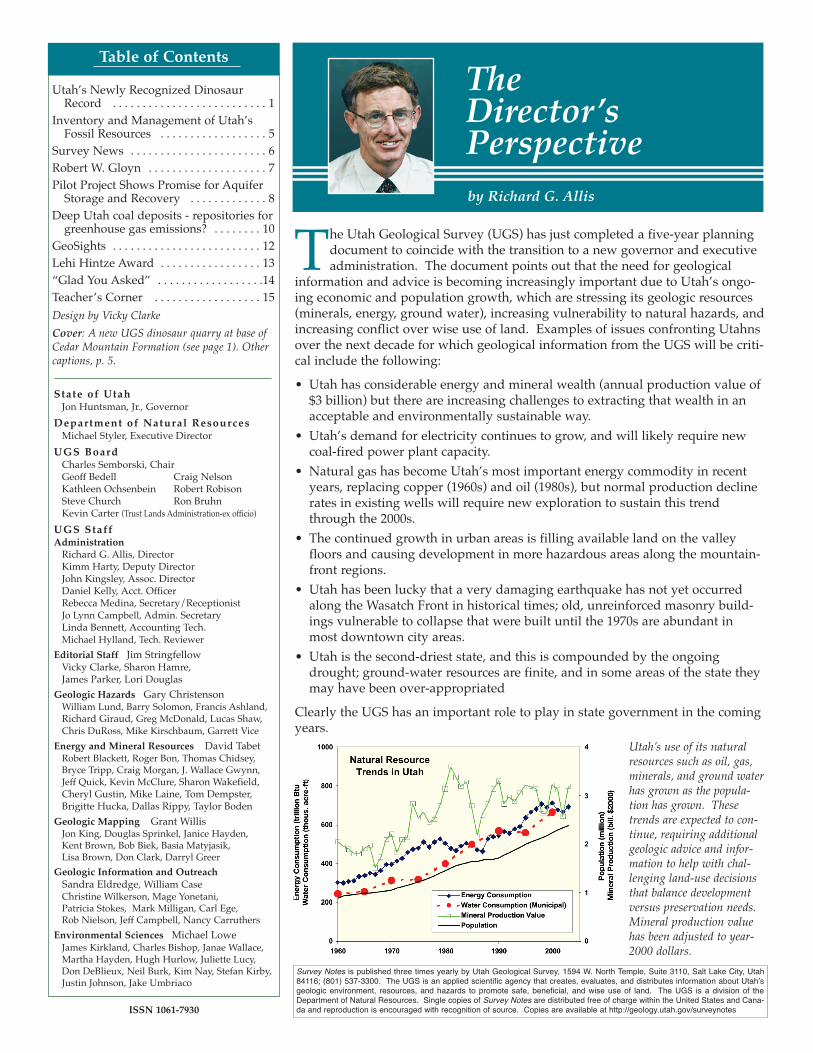
Table of Contents
The Utah Geological Survey (UGS) has just completed a five-year planningdocument to coincide with the transition to a new governor and executiveadministration. The document points out that the need for geological
information and advice is becoming increasingly important due to Utah’s ongo-ing economic and population growth, which are stressing its geologic resources(minerals, energy, ground water), increasing vulnerability to natural hazards, andincreasing conflict over wise use of land. Examples of issues confronting Utahnsover the next decade for which geological information from the UGS will be criti-cal include the following:• Utah has considerable energy and mineral wealth (annual production value of
$3 billion) but there are increasing challenges to extracting that wealth in anacceptable and environmentally sustainable way.
• Utah’s demand for electricity continues to grow, and will likely require newcoal-fired power plant capacity.
• Natural gas has become Utah’s most important energy commodity in recentyears, replacing copper (1960s) and oil (1980s), but normal production declinerates in existing wells will require new exploration to sustain this trendthrough the 2000s.
• The continued growth in urban areas is filling available land on the valleyfloors and causing development in more hazardous areas along the mountain-front regions.
• Utah has been lucky that a very damaging earthquake has not yet occurredalong the Wasatch Front in historical times; old, unreinforced masonry build-ings vulnerable to collapse that were built until the 1970s are abundant inmost downtown city areas.
• Utah is the second-driest state, and this is compounded by the ongoingdrought; ground-water resources are finite, and in some areas of the state theymay have been over-appropriated
Clearly the UGS has an important role to play in state government in the comingyears.
The Director’sPerspectiveby Richard G. Allis
State of UtahJon Huntsman, Jr., Governor
Department of Natural ResourcesMichael Styler, Executive Director
UGS BoardCharles Semborski, ChairGeoff Bedell Craig NelsonKathleen Ochsenbein Robert RobisonSteve Church Ron BruhnKevin Carter (Trust Lands Administration-ex officio)
UGS StaffAdministration
Richard G. Allis, DirectorKimm Harty, Deputy DirectorJohn Kingsley, Assoc. DirectorDaniel Kelly, Acct. OfficerRebecca Medina, Secretary/ReceptionistJo Lynn Campbell, Admin. SecretaryLinda Bennett, Accounting Tech. Michael Hylland, Tech. Reviewer
Editorial Staff Jim StringfellowVicky Clarke, Sharon Hamre,James Parker, Lori Douglas
Geologic Hazards Gary ChristensonWilliam Lund, Barry Solomon, Francis Ashland, Richard Giraud, Greg McDonald, Lucas Shaw, Chris DuRoss, Mike Kirschbaum, Garrett Vice
Energy and Mineral Resources David TabetRobert Blackett, Roger Bon, Thomas Chidsey, Bryce Tripp, Craig Morgan, J. Wallace Gwynn, Jeff Quick, Kevin McClure, Sharon Wakefield,Cheryl Gustin, Mike Laine, Tom Dempster, Brigitte Hucka, Dallas Rippy, Taylor Boden
Geologic Mapping Grant WillisJon King, Douglas Sprinkel, Janice Hayden, Kent Brown, Bob Biek, Basia Matyjasik, Lisa Brown, Don Clark, Darryl Greer
Geologic Information and OutreachSandra Eldredge, William CaseChristine Wilkerson, Mage Yonetani, Patricia Stokes, Mark Milligan, Carl Ege, Rob Nielson, Jeff Campbell, Nancy Carruthers
Environmental Sciences Michael LoweJames Kirkland, Charles Bishop, Janae Wallace, Martha Hayden, Hugh Hurlow, Juliette Lucy,Don DeBlieux, Neil Burk, Kim Nay, Stefan Kirby,Justin Johnson, Jake Umbriaco
Utah’s Newly Recognized DinosaurRecord . . . . . . . . . . . . . . . . . . . . . . . . . . 1
Inventory and Management of Utah’sFossil Resources . . . . . . . . . . . . . . . . . . 5
Survey News . . . . . . . . . . . . . . . . . . . . . . . 6Robert W. Gloyn . . . . . . . . . . . . . . . . . . . . 7Pilot Project Shows Promise for Aquifer
Storage and Recovery . . . . . . . . . . . . . 8Deep Utah coal deposits - repositories for
greenhouse gas emissions? . . . . . . . . 10GeoSights . . . . . . . . . . . . . . . . . . . . . . . . . 12Lehi Hintze Award . . . . . . . . . . . . . . . . . 13“Glad You Asked” . . . . . . . . . . . . . . . . . .14Teacher’s Corner . . . . . . . . . . . . . . . . . . 15Design by Vicky ClarkeCover: A new UGS dinosaur quarry at base ofCedar Mountain Formation (see page 1). Othercaptions, p. 5.
ISSN 1061-7930
Survey Notes is published three times yearly by Utah Geological Survey, 1594 W. North Temple, Suite 3110, Salt Lake City, Utah84116; (801) 537-3300. The UGS is an applied scientific agency that creates, evaluates, and distributes information about Utah’sgeologic environment, resources, and hazards to promote safe, beneficial, and wise use of land. The UGS is a division of theDepartment of Natural Resources. Single copies of Survey Notes are distributed free of charge within the United States and Cana-da and reproduction is encouraged with recognition of source. Copies are available at http://geology.utah.gov/surveynotes
Utah’s use of its naturalresources such as oil, gas,minerals, and ground waterhas grown as the popula-tion has grown. Thesetrends are expected to con-tinue, requiring additionalgeologic advice and infor-mation to help with chal-lenging land-use decisionsthat balance developmentversus preservation needs.Mineral production valuehas been adjusted to year-2000 dollars.

IntroductionMany of Utah’s sedimentary rock layers contain abundantfossils and other features that have given us a wealth ofinformation about dinosaurs and the environmental con-ditions under which they lived. With sites such as theCarnegie Quarry at Dinosaur National Monument innortheastern Utah, and the Cleveland-Lloyd Quarrysouthwest of Price, Utah is justifiably famous for itsdinosaurs from the Late Jurassic Morrison Formation.Likewise, Utah’s Late Cretaceous dinosaur record is wellknown as the most complete in the world, owing to theextraordinary fossil record preserved in southern Utah.However, rocks from the Early Cretaceous period haduntil recently yielded little information about thedinosaurs that lived here during that time. Only over thepast decade have new discoveries revealed the importanceof dinosaurs preserved in Utah’s Early Cretaceous CedarMountain Formation. This recently recognized dinosaurrecord permits for the first time a detailed reconstructionof Utah’s Early Cretaceous geology, biology, geography,and climate.In 1944 the University of Utah’s William Lee Stokesapplied the name Cedar Mountain Shale to drab, slope-forming rocks lying between the Buckhorn Conglomerateand Dakota Formation, based on a type-section defined onthe southwest flank of Cedar Mountain at the north end ofthe San Rafael Swell in Emery Co., Utah. In 1952, herenamed it the Cedar Mountain Formation and includedthe Buckhorn Conglomerate as its basal member. Backthen, where the cliff-forming Buckhorn is not present, therule of thumb for distinguishing the Cedar Mountain fromthe underlying Morrison Formation included (1) its moredrably variegated color, (2) its more abundant carbonatenodules often with a thick carbonate paleosol (ancient soil)at the base, (3) the presence of common polished chertpebbles identified as gastroliths (dinosaur stomachstones), and (4) the absence of dinosaur bones.
The reported absence of dinosaur bones in the CedarMountain Formation limited the number of paleontolo-gists investigating these rocks for many years. Becausegeologists lacked any accepted means of subdividing theserocks, they were long considered to be a rather monoto-nous sequence of Early Cretaceous strata that generallythicken to the west. Then, new dinosaur species reportedin the mid-1990s led to a rush of institutions searching forthe dinosaurs in the Cedar Mountain Formation. BrighamYoung University, College of Eastern Utah PrehistoricMuseum, Denver Museum of Nature and Science,Dinosaur National Monument, Oklahoma Museum ofNatural History, and the Utah Geological Survey are justsome of the many research groups presently looking forfossils. A wealth of new fossil sites, and some radiometricdates, have established that the relatively thin layer (nor-mally less than 100 meters) of Early Cretaceous CedarMountain Formation, which separates thousands of
SU RV E Y NO T E S 1
Utah’s Newly Recognized DinosaurRecord from the Early Cretaceous
Cedar Mountain Formation
Utah’s Newly Recognized DinosaurRecord from the Early Cretaceous
Cedar Mountain Formationby James I. Kirkland
Outcrop of Cedar Mountain Formation in east-central Utah.
SU RV E Y NO T E S2
meters of Jurassic rocks and thou-sands of meters of Late Cretaceousrocks, is more complex than previous-ly thought. Additionally, it preservesnearly 30 million years of what maybe the most interesting episode ofdinosaur history apart from their ori-gin and extinction.In 1997, using the distribution of spe-cific dinosaur faunas (groups ofdinosaurs living together) and theirrelationship to distinct rock types, Idefined four additional members ofthe Cedar Mountain Formation. Inascending order, these are the YellowCat Member, Poison Strip Sandstone,Ruby Ranch Member, and Mussentu-chit Member. Together with the Buck-horn Conglomerate, these rock unitsand the fossils they contain are shed-ding light on the previously obscureEarly Cretaceous history of Utah.
Stratigraphy and Dinosaurs of theCedar Mountain FormationBuckhorn Conglomerate
The basal Buckhorn Conglomerateconsists largely of a chert-pebble tocobble conglomerate up to 25 metersthick that defines a northeast-flowingriver system extending along the westflank of the San Rafael Swell. Thechert pebbles preserve Late Paleozoicmarine fossils reworked from ancientmountains in northwest Arizona andNevada. In recent years, a controver-
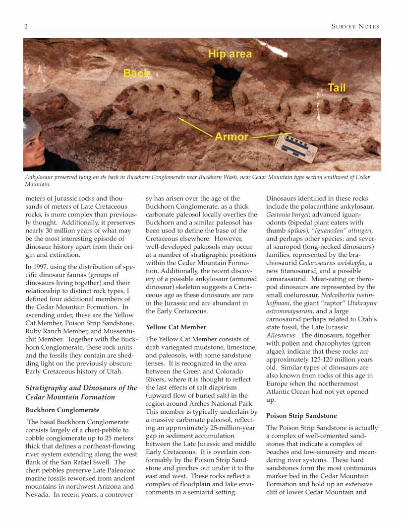
sy has arisen over the age of theBuckhorn Conglomerate, as a thickcarbonate paleosol locally overlies theBuckhorn and a similar paleosol hasbeen used to define the base of theCretaceous elsewhere. However,well-developed paleosols may occurat a number of stratigraphic positionswithin the Cedar Mountain Forma-tion. Additionally, the recent discov-ery of a possible ankylosaur (armoreddinosaur) skeleton suggests a Creta-ceous age as these dinosaurs are rarein the Jurassic and are abundant inthe Early Cretaceous.
Yellow Cat Member
The Yellow Cat Member consists ofdrab variegated mudstone, limestone,and paleosols, with some sandstonelenses. It is recognized in the areabetween the Green and ColoradoRivers, where it is thought to reflectthe last effects of salt diapirism(upward flow of buried salt) in theregion around Arches National Park.This member is typically underlain bya massive carbonate paleosol, reflect-ing an approximately 25-million-yeargap in sediment accumulationbetween the Late Jurassic and middleEarly Cretaceous. It is overlain con-formably by the Poison Strip Sand-stone and pinches out under it to theeast and west. These rocks reflect acomplex of floodplain and lake envi-ronments in a semiarid setting.
Dinosaurs identified in these rocksinclude the polacanthine ankylosaur,Gastonia burgei; advanced iguan-odonts (bipedal plant eaters withthumb spikes), “Iguanodon” ottingeri,and perhaps other species; and sever-al sauropod (long-necked dinosaurs)families, represented by the bra-chiosaurid Cedarosaurus weiskopfae, anew titanosaurid, and a possiblecamarasaurid. Meat-eating or thero-pod dinosaurs are represented by thesmall coelurosaur, Nedcolbertia justin-hoffmani, the giant “raptor” Utahraptorostrommaysorum, and a largecarnosaurid perhaps related to Utah’sstate fossil, the Late JurassicAllosaurus. The dinosaurs, togetherwith pollen and charophytes (greenalgae), indicate that these rocks areapproximately 125-120 million yearsold. Similar types of dinosaurs arealso known from rocks of this age inEurope when the northernmostAtlantic Ocean had not yet openedup.
Poison Strip Sandstone
The Poison Strip Sandstone is actuallya complex of well-cemented sand-stones that indicate a complex ofbeaches and low-sinuosity and mean-dering river systems. These hardsandstones form the most continuousmarker bed in the Cedar MountainFormation and hold up an extensivecliff of lower Cedar Mountain and
Ankylosaur preserved lying on its back in Buckhorn Conglomerate near Buckhorn Wash, near Cedar Mountain type section southwest of CedarMountain.

SU
RV
EY
NO
TE
S3
A generalized column of Utah’s Late Mesozoic strata plotted against the geological time scale with a summary of Utah’s preserved dinosaur faunas and resulting continental paleogeographicpatterns these dinosaurs indicate.

upper Morrison Formation extendingacross much of east-central Utah. Pet-rified logs and cycads are common inthese beds. Dinosaurs are less com-monly preserved and includeGastonia, the iguanodont Planicoxavenenica, and the titanosaurimorphsauropod Venenosaurus dicrocei. Over-all the fossils suggest persistence ofthe Yellow Cat fauna.
Ruby Ranch Member
The Ruby Ranch Member is presenteverywhere the Cedar Mountain For-mation is recognized and thickens tothe northwest, perhaps indicating theearliest development of a forelandbasin caused by initial Cretaceousthrust faulting in central Utah. Itsappearance is much like the YellowCat Member, except that carbonatenodules are much more common andcover the ground. These representpaleosols and ephemeral pondsformed under semiarid conditions.Ribbon sandstones representing low-sinuosity rivers are common in thismember. Dinosaurs from these rocksare completely distinct from thoseidentified in the underlying rocks.The armored ankylosaurs are particu-larly diverse and include anodosaurid similar to Sauropelta, aswell as a giant nodosaurid and thehuge ankylosaurid, Cedarpelta bilbyhal-lorum, in the uppermost part of themember. Other plant-eaters includethe primitive, large ornithopod Tenon-tosaurus, with sauropods representedby slender-toothed brachiosaurs thatmay represent several species and areoften referred to as Astrodon or Pleuro-coelus. Meat-eating theropods are rep-resented by small raptors similar toDeinonychus, a large undescribedcarnosaurid, and the huge, high-spined Acrocanthosaurus. Similardinosaur faunas are known acrossmuch of North America and suggestthat these rocks were formed 115-105million years ago when floweringplants first radiated and came to dom-inate the world’s floras. However,this particular dinosaur assemblage isknown only from North America,suggesting isolation from the rest of
the world as the result of rising sealevels flooding Europe and westernCanada prior to the development ofAlaska. The rather low diversity ofdinosaurs across all of North Americafor this interval lends further supportto the concept of North America as anisland continent during this time.
Mussentuchit Member
The uppermost Mussentuchit Memberis well developed only along the westside of the San Rafael Swell. It is sep-arated from the underlying RubyRanch Member by a black chert-peb-ble lag except in the thick outcrops ofCedar Mountain Formation on thenorth end of the San Rafael Swell,where the contact appears gradation-al. The top of the Mussentuchit, andlaterally the Ruby Ranch, is overlainby the Dakota Formation and, whereremoved by Late Cretaceous erosion,the Tununk Member of the MancosShale. The Mussentuchit is mostreadily distinguished by the abun-dance of smectite (altered volcanicash) mixed into its mudstones, a nearabsence of carbonate nodules, and thelocal presence of lignite (low-gradecoal) beds. Locally, the smectite is sopure that the swelling clays are minedfor this industrial material. A radio-metric age of 98.37 ± 0.07 millionyears, obtained by the OklahomaMuseum of Natural History from vol-canic ash within the MussentuchitMember, coincides with the Early Cre-taceous/Late Cretaceous boundary.The Oklahoma Museum of NaturalHistory has been using wet screen-washing techniques to recover tinyfossil mammal remains frommicrovertebrate sites in the Mussentu-chit Member. By sorting the boneresidues generated in this way, theyhave recognized about 80 speciesincluding a diversity of fish, frogs,salamanders, turtles, lizards, the old-est North American snake, crocodil-ians, birds, and mammals (includingthe oldest North American marsupial,Kokopelia). A wealth of dinosaur teethhave also been recovered representingankylosaurid and nodosaurid anky-losaurs, several ornithopod taxa (a
new small species, Tenontosaurus, andEolambia), tiny slender brachiosauridsauropod teeth (the last known inNorth America until the titanosauridAlamosaurus appears more than 30million years later in the North HornFormation), dome-headed pachy-cephalosaurs, and primitive horneddinosaurs. Meat-eating dinosaurteeth are diverse and abundant,including primitive coelurosaurs,troodontids, dromaeosaurine andvelociraptorine dromaeosaurids, andNorth America’s earliest knowntyrannosaurids. A partial skeleton ofwhat may be a toothlessornithomimid (ostrich-mimic) has alsobeen recovered. So far only two dinosaur species, nowhoused in the collections of the Col-lege of Eastern Utah Prehistoric Muse-um in Price, Utah, have beendescribed from relatively completeskeletal remains from these rocks.They are named for a husband/wifeteam of amateur paleontologists liv-ing in Castle Dale, Utah. Theadvanced ornithopod Eolambia car-oljonesa was named for Carol Jones,who discovered the site. Retired Uni-versity of Utah radiological technicianRamal Jones discovered the skeletonof the primitive nodosaurid anky-losaur, Animantarx ramaljonesi, as partof a highly refined radiological surveyof the Carol site. This is the onlydinosaur ever discovered thus far bytechnology alone.The Mussentuchit fauna is particular-ly interesting in that it is the first timewe find dinosaurs representing all thefamilies that are so characteristic ofthe remainder of the Late Cretaceousin North America, in addition to pre-serving a few last examples of EarlyCretaceous dinosaurs. As the directancestors of the tyrannosaurids, thederived iguanodont Eolambia, and themarsupial Kokopelia are Asian animals;this suggests that these rocks docu-ment the first immigration event ofanimals across the “Alaska LandBridge.” This event is reported tohave led to the extinction of many ofNorth America’s “homegrown”(endemic) dinosaur groups. The
SU RV E Y NO T E S4

Alaskan Land Bridge has remained animportant migration corridor for lifeon land in the northern hemisphere tothe present day. As the MussentuchitMember appears to preserve a mix-ture of Early and Late Cretaceousdinosaurs, it can be said that Utah’sdinosaurs are dating the origin ofAlaska, having caught the immigra-tion-induced extinction in the act.
ConclusionsUtah’s Cedar Mountain dinosaurs arecontributing critical information about
an important period of time in the his-tory of terrestrial life in the northernhemisphere. Globally, this was atime of changing climatic conditionsduring a period of exceptionally highcarbon dioxide causing “super-green-housing” (a world with no polar ice-caps and a sluggish, poorly oxygenat-ed ocean), major restructuring of bio-geographic migration corridors, and acomplete restructuring of plant com-munities with the origin and rapidrise to dominance of flowering plants.The UGS continues to discover and
integrate new data from the CedarMountain Formation into an increas-ingly robust history of Utah duringthe Early Cretaceous and its relation-ship with the rest of the world. Con-tinued new dinosaur discoveries onlyserve to show that Utah has the mostcomplete dinosaur record in all ofNorth America, and that there is still agreat deal to learn from it.Cover: Skull is holotype for armoreddinosaur Gastonia burgei, as is tooth;claws are from hind foot of Utahrap-tor ostrommaysorum.
SU RV E Y NO T E S 5
Paleontological resources are man-aged mainly for their scientific value,but also for their educational andrecreational values. In this context,Utah’s fossils are among the state’sunique and valuable naturalresources. Different types of fossilsrequire different resource-manage-ment strategies. So how are theseresources managed, and who isresponsible for their management?
Cooperation among various types ofproperty owners and land-manage-ment agencies is one key to effectivepaleontological resource manage-ment. Fossils are found on private,state, and federal lands. Laws pro-tecting fossils on private land do notexist, so we must rely on education asa resource-management strategy.Government land-management agen-cies each have their own rules andresponsibilities for managing fossilsand other resources on lands undertheir jurisdiction. At times, manage-ment of other types of resources takesprecedence over management of pale-ontological resources. However, thevalue of fossils on public lands is rec-
ognized by most, if not all, land-man-agement agencies. A report releasedby the Department of the Interior in2000, "Assessment of Fossil Manage-ment on Federal and Indian Lands,"was developed with the cooperation
of eight federal agencies: Bureau ofIndian Affairs, Bureau of Land Man-agement, Bureau of Reclamation, U.S.Fish and Wildlife Service, U.S. ForestService, National Park Service, Smith-sonian Institution, and U.S. Geologi-
Inventory and Management of Utah’s Fossil ResourcesInventory and Management of Utah’s Fossil Resources
by Martha Hayden
Elaine and Earl Gowin look on while UGS paleontologist Don DeBlieux and his wife Jane jacketa mammoth tusk discovered in a gravel pit on the Gowin's farm near Fillmore, Utah. Fossilslike this tusk are common in the shoreline gravels of Lake Bonneville, an Ice Age lake that cov-ered much of western Utah. The addition of significant new localities like this to our paleonto-logical locality database adds to our understanding of prehistoric life in Utah.

SU RV E Y NO T E S6
cal Survey. That report lists seven"basic principles" for development offuture legislation governing the treat-ment of fossils on public lands. Thebasic principles are:
• Fossils on federal land are a partof America's heritage.
• Most vertebrate fossils are rare.
• Some invertebrate and plant fos-sils are rare.
• Penalties for fossil theft should bestrengthened.
• Effective stewardship requiresaccurate information.
• Federal fossil collections shouldbe preserved and available forresearch and public education.
• Federal fossil management shouldemphasize opportunities for pub-lic involvement.
The UGS is not a land-managementagency. However, Utah State Code,which provides legal authority to theUGS, establishes the state's "interest inthe preservation and protection of thestate's paleontological resources and aright to the knowledge derived andgained from the scientific study ofthese resources." Utah State Codealso assigns authority to the UGS to“collect and distribute informationregarding the …paleontology… of thestate; … stimulate research, study andactivities in the field of paleontology;
… mark, protect, and preserve criticalpaleontological sites;” and “collect,maintain, and preserve data andinformation in order to accomplishthe purposes of this section and act asa repository of information concern-ing the geology of this state.” TheUGS is also charged with the authori-ty to issue permits for qualified pale-ontologists to excavate critical paleon-tological resources from state lands.In other words, the UGS is chargedwith the responsibility for the preser-vation and protection of Utah’s pale-ontological resources from state lands,and has a mandate to collect informa-tion about fossils.Effective data management is anotherkey to successful management ofpaleontological resources; to this endthe UGS Paleontology Section main-tains a paleontological locality data-base for the state of Utah. This data-base includes 9,699 localities from alllands in Utah. Our authority to com-pile and maintain locality data isderived from partnerships and coop-erative agreements with state and fed-eral land-management agencies. Inparticular, the UGS has had a cooper-ative agreement since 2002 with theUtah State Office of the Bureau ofLand Management (BLM) for themanagement of paleontologicalresource data for BLM lands withinthe state. The BLM manages 23 mil-lion acres of land in Utah (42% of thestate’s land area), the largest area of
any single land-management agencyin the state. Under our agreementwith the BLM, the main focus of workhas been to convert existing paleonto-logical locality data into a format thatcan be used in a Geographic Informa-tion System (GIS).
To protect critical fossil resources fromvandalism and unauthorized collect-ing, information in the locality data-base is released only to land managersand qualified paleontologists engagedin paleontological mitigation andresearch. The only specific localitydata released to the general public arefor those sites that are open to publicvisitation. For example, informationabout the St. George Dinosaur Track-site can be found on our website athttp://geology.utah.gov/online/pdf/pi-78.pdf, including a locality map forvisitors as well as a summary of theongoing paleontological research.
We also have, or have had, variouscooperative agreements for specificpaleontological resource-managementprojects with many agencies, includ-ing Zion National Park, the Bureau ofReclamation, and the U.S. Forest Ser-vice at Flaming Gorge National Mon-ument, and Grand Staircase-EscalanteNational Monument. These projectsinvolve using our locality databaseand GIS analysis to produce paleonto-logical sensitivity maps and addressspecific research and managementissues.
Welcome aboard to lots of new faces:Our temporary geophysicist is JakeUmbriaco, a recent graduate of theUniversity of Utah, working with theGround-water Section. MikeKirschbaum comes back as a tempo-rary geologist with the Hazards Pro-gram, Garrett Vice has been hired asa temporary geologist with our CedarCity office, Stefan Kirby is working
with the Ground-water Section, andCarole McCalla will be helping out inGIO, in particular, increasing thenumber of school kits that we haveavailable. Justin Johnson replacesMatt Butler as GIS person for theEnvironmental Sciences. Matt is leav-ing for the private sector, and Justinworked with us previously.
Carolyn Olsen leaves us after 25
years with UGS, the last 17 as Curatorof the Core Research Center. The newmanager is Mike Laine, who man-aged the predecessor of the Center in1986-88, then spent four years withOil Gas, & Mining. He has since beena consulting geologist and petroleumgeologist working in the Uinta Basinwith Questar, and as a subcontractorwith the UGS on the Ferron project.
Survey News
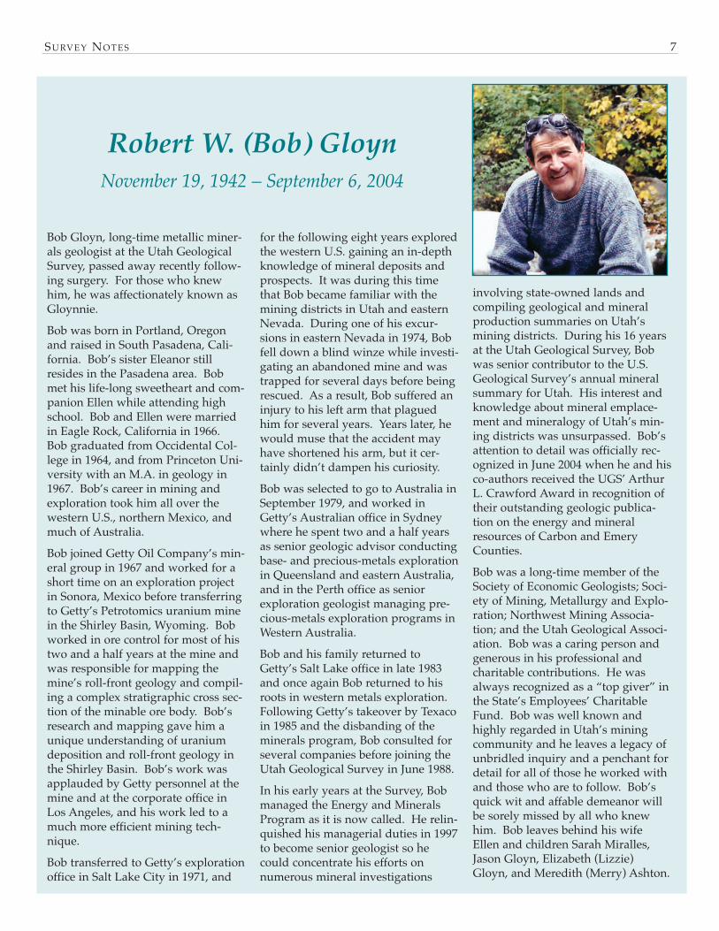
Bob Gloyn, long-time metallic miner-als geologist at the Utah GeologicalSurvey, passed away recently follow-ing surgery. For those who knewhim, he was affectionately known asGloynnie. Bob was born in Portland, Oregonand raised in South Pasadena, Cali-fornia. Bob’s sister Eleanor stillresides in the Pasadena area. Bobmet his life-long sweetheart and com-panion Ellen while attending highschool. Bob and Ellen were marriedin Eagle Rock, California in 1966.Bob graduated from Occidental Col-lege in 1964, and from Princeton Uni-versity with an M.A. in geology in1967. Bob’s career in mining andexploration took him all over thewestern U.S., northern Mexico, andmuch of Australia. Bob joined Getty Oil Company’s min-eral group in 1967 and worked for ashort time on an exploration projectin Sonora, Mexico before transferringto Getty’s Petrotomics uranium minein the Shirley Basin, Wyoming. Bobworked in ore control for most of histwo and a half years at the mine andwas responsible for mapping themine’s roll-front geology and compil-ing a complex stratigraphic cross sec-tion of the minable ore body. Bob’sresearch and mapping gave him aunique understanding of uraniumdeposition and roll-front geology inthe Shirley Basin. Bob’s work wasapplauded by Getty personnel at themine and at the corporate office inLos Angeles, and his work led to amuch more efficient mining tech-nique.Bob transferred to Getty’s explorationoffice in Salt Lake City in 1971, and
for the following eight years exploredthe western U.S. gaining an in-depthknowledge of mineral deposits andprospects. It was during this timethat Bob became familiar with themining districts in Utah and easternNevada. During one of his excur-sions in eastern Nevada in 1974, Bobfell down a blind winze while investi-gating an abandoned mine and wastrapped for several days before beingrescued. As a result, Bob suffered aninjury to his left arm that plaguedhim for several years. Years later, hewould muse that the accident mayhave shortened his arm, but it cer-tainly didn’t dampen his curiosity.Bob was selected to go to Australia inSeptember 1979, and worked inGetty’s Australian office in Sydneywhere he spent two and a half yearsas senior geologic advisor conductingbase- and precious-metals explorationin Queensland and eastern Australia,and in the Perth office as seniorexploration geologist managing pre-cious-metals exploration programs inWestern Australia.Bob and his family returned toGetty’s Salt Lake office in late 1983and once again Bob returned to hisroots in western metals exploration.Following Getty’s takeover by Texacoin 1985 and the disbanding of theminerals program, Bob consulted forseveral companies before joining theUtah Geological Survey in June 1988. In his early years at the Survey, Bobmanaged the Energy and MineralsProgram as it is now called. He relin-quished his managerial duties in 1997to become senior geologist so hecould concentrate his efforts onnumerous mineral investigations
involving state-owned lands andcompiling geological and mineralproduction summaries on Utah’smining districts. During his 16 yearsat the Utah Geological Survey, Bobwas senior contributor to the U.S.Geological Survey’s annual mineralsummary for Utah. His interest andknowledge about mineral emplace-ment and mineralogy of Utah’s min-ing districts was unsurpassed. Bob’sattention to detail was officially rec-ognized in June 2004 when he and hisco-authors received the UGS’ ArthurL. Crawford Award in recognition oftheir outstanding geologic publica-tion on the energy and mineralresources of Carbon and EmeryCounties. Bob was a long-time member of theSociety of Economic Geologists; Soci-ety of Mining, Metallurgy and Explo-ration; Northwest Mining Associa-tion; and the Utah Geological Associ-ation. Bob was a caring person andgenerous in his professional andcharitable contributions. He wasalways recognized as a “top giver” inthe State’s Employees’ CharitableFund. Bob was well known andhighly regarded in Utah’s miningcommunity and he leaves a legacy ofunbridled inquiry and a penchant fordetail for all of those he worked withand those who are to follow. Bob’squick wit and affable demeanor willbe sorely missed by all who knewhim. Bob leaves behind his wifeEllen and children Sarah Miralles,Jason Gloyn, Elizabeth (Lizzie)Gloyn, and Meredith (Merry) Ashton.
SU RV E Y NO T E S 7
Robert W. (Bob) Gloyn November 19, 1942 – September 6, 2004

SU RV E Y NO T E S8
The pilot project for the Ogden-area aquifer storage and recoveryproject described in the August
2003 issue of Survey Notes is wellunderway. Aquifer storage andrecovery projects involve the storageof water in an aquifer via artificialground-water recharge when water isavailable, and recovery of the storedwater from the aquifer when water isneeded. Pre-experiment work includ-ed establishing a monitoring well atthe site, measuring water levels in themonitoring well and other nearbywells, analyzing water quality fromnearby wells and the Weber River,and performing microgravity surveys.In March 2004, water from the WeberRiver was diverted into four shallowinfiltration ponds on coarse-grainedriver deposits at the pilot-project site.The 1- to 2-foot-deep ponds have atotal area of about 3.7 acres. When the diversion of water from theWeber River was completed in July2004, the aquifer beneath the projectsite had received about 800 acre-feetof ground-water recharge, resulting ina water-level rise of about one foot inthe monitoring well at the site. Alow-permeability layer (a sedimentlayer that allows water to movethrough it less readily than adjacent
layers) about 120 feet below the landsurface at the project site caused theinfiltrating ground water to spreadlaterally, resulting in lower water-level increases at the monitoring wellthan were anticipated prior to theexperiment. During the same timeperiod, water levels in other nearbywells declined 4 to 10 feet; this indi-cates water levels at the monitoringwell would have actually declined atleast a few feet in the absence of therecharge experiment, so the net water-level rise at the monitoring well was
at least 4 feet. Microgravity surveys conductedbefore, during, and after the time ofinfiltration clearly show the building,migration, and dispersal of the newlycreated ground-water mound belowand adjacent to the recharge ponds.Microgravity has proven to be aninvaluable tool to monitor the subsur-face movement of ground water infil-trated from the recharge ponds, giventhe insufficient number of suitablemonitoring wells adjacent to therecharge site.
Two of the four shallow infiltration ponds at Ogden-area aquifer storage and recovery project site.
by Mike Lowe and Hugh Hurlow

SU RV E Y NO T E S 9
A digital ground-water flow model iscurrently being constructed toimprove our understanding of theaquifer system and the effects of theground-water recharge experiment.Post-experiment water-level, water-quality, and microgravity data willcontinue to be collected until May2005.
Although the recharge rate at thepilot-project site is lower than antici-pated, the project has been enough ofa success that the Weber Basin WaterConservancy District has purchasedthe site property, and plans are beingconsidered for implementing aquiferstorage and recovery at the site on apermanent basis beginning nextspring. The preliminary results of thispilot project, combined with rechargeexperiments conducted near themouth of Weber Canyon in the 1950s,indicate a strong likelihood for the
success of similar aquifer storage andrecovery projects in the greater eastshore area of Great Salt Lake, whereground-water levels have declined upto 50 feet since the late 1930s. Activegravel pits in the area may be poten-tial sites for future infiltration pondswhen the gravel resources becomedepleted.
This project highlights the ability ofmany entities to successfully worktoward a common goal. Project par-ticipants include the Weber BasinWater Conservancy District, U.S.Bureau of Reclamation, Weber StateUniversity Department of Geo-sciences, University of Utah Depart-ment of Geology and Geophysics,Utah Division of Water Resources,and Utah Geological Survey. Addi-tional information regarding theOgden-area pilot project is athttp://weberbasin.com/aquifer.
Schematic diagram showing low-permeability layer and water levels atOgden-area aquifer storage and recovery project site. Arrows indicateground-water movement.
Marek Matyjasek (Weber State University), Mike Lowe (Utah Geologi-cal Survey), and Ben Everitt (Utah Division of Water Resources) meas-ure ground-water levels in monitoring well at Ogden-area aquifer stor-age and recovery project site.
Schematic map showing area of ground-watermound associated with infiltration ponds atOgden-area aquifer storage and recovery proj-ect site.
SU RV E Y NO T E S10
Concern about potential globalwarming caused by greenhouse gasemissions from the burning of fossilfuels has prompted the Utah Geolog-ical Survey to join a consortium ofresearchers from several westernstates (Arizona, Colorado, NewMexico, and Oklahoma) to investi-gate geologic reservoirs that couldpossibly be used to permanentlystore such emissions. Coal is knownfor its ability to hold significantamounts of carbon dioxide, a green-house gas, within its molecularstructure. Coal beds at depthsgreater than 2000 feet are logisticallyand economically difficult to minebecause of the high pressures andstresses that occur at these depths.Such less-likely-to-be-mined coaldeposits are present in east-centralUtah, in the Book Cliffs, Emery,Sego, and Wasatch Plateau coalfields(see figure). Any of those coaldeposits located within about 20miles of the various Utah coal-firedpower plants are logical targets tostore greenhouse gas emissionsbecause they are close enough to thesource to make an emission-storageproject potentially economic. Targetcoal deposits at depths ranging from2000 to 6000 feet are present in Utahin the Blackhawk and Neslen Forma-tions of the Mesaverde Group, andthe underlying Ferron and EmerySandstone Members of the MancosShale. The Utah Energy Office has invento-ried the amount of carbon dioxide
emitted annually by Utah’s coal-fired electric power plants andfound that the amount varies up to12.5 million tons depending on thesize of the plant. Although no deepcoal deposits occur within 20 milesof the Intermountain Power Plant inwestern Utah, several power plantsnear the Book Cliffs and WasatchPlateau coalfields are well situatedto take advantage of deep coal bedsfor sequestering greenhouse gasemissions. Comparison of the annu-al carbon dioxide emission rates forthese power plants with the coalreservoir storage capacities, showsthat most of the central Utah coal-fired power plants could have theircarbon dioxide emissions stored indeep coal reservoirs for a good por-tion of their expected useful life-times. The deep coal deposits in theEmery coalfield near Price are cur-rently being tapped for their storedeconomic methane gas reserves, and
a network of pipelines and wells iscurrently in place that could also beused for carbon dioxide sequestra-tion efforts. As methane reserves inthat area decline, pumping green-house gases into the coal reservoirsmight have the added benefit ofenhancing methane production byflushing out additional recoverablecoalbed methane.Based on this quick inventory, itappears that deep coal resourcesnear existing coal-fired power plantsin central Utah could theoreticallyprovide adequate reservoirs to storecarbon dioxide emissions for at least35 years, or the expected life of atleast several of the power plants.Whether it is technically and eco-nomically feasible to sequestergreenhouse gas emissions of coal-fired power plants in deep coal bedsremains the subject of futureresearch.
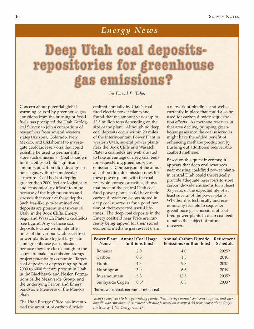
Power Plant Annual Coal Usage Annual Carbon Dioxide Retirement Name (millions tons) Emissions (million tons) Schedule
Bonanza 2.0 4.0 2025?Carbon 0.6 1.5 2010Hunter 4.3 9.8 2025Huntington 3.0 6.6 2019Intermountain 5.3 12.5 2035? Sunnyside Cogen 0.5* 0.3 2033?
*burns waste coal, not run-of-mine coal
Utah’s coal-fired electric generating plants, their average annual coal consumption, and car-bon dioxide emissions. Retirement schedule is based on assumed 40-year power plant designlife (source: Utah Energy Office).
by David E. Tabet
Energy News

SU RV E Y NO T E S 11
Coalfield Geologic Acres within Average coal Coal reservoir CO2 storage name unit name 20 miles thickness (ft) size (tons) capacity(tons)Book Cliffs Blackhawk 70,000 35 4,410 44.1Wasatch Plat. Blackhawk 40,000 20 1,440 14.4Wasatch Plat. Emery 150,000 40 10,800 108.0Emery Ferron 96,000 24 4,147 41.5Sego Neslen 45,000 14 1,134 11.3TOTAL 401,000 31 21,931 219.3
Estimates for Utah coalfields of the area, average thickness, reservoir size, and carbon dioxide storage capacity of deep coal deposits that liewithin 20 miles of coal-fired power plants (tonnages are millions of short tons).
SU RV E Y NO T E S12
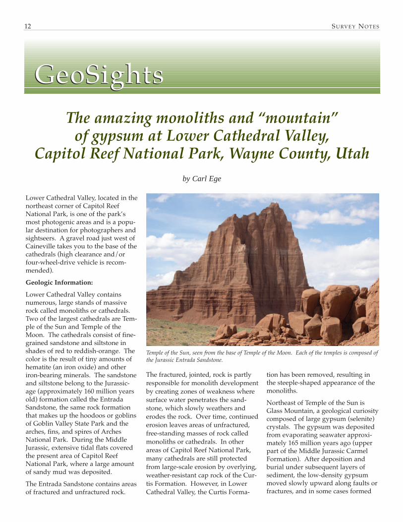
Lower Cathedral Valley, located in thenortheast corner of Capitol ReefNational Park, is one of the park’smost photogenic areas and is a popu-lar destination for photographers andsightseers. A gravel road just west ofCaineville takes you to the base of thecathedrals (high clearance and/orfour-wheel-drive vehicle is recom-mended). Geologic Information:
Lower Cathedral Valley containsnumerous, large stands of massiverock called monoliths or cathedrals.Two of the largest cathedrals are Tem-ple of the Sun and Temple of theMoon. The cathedrals consist of fine-grained sandstone and siltstone inshades of red to reddish-orange. Thecolor is the result of tiny amounts ofhematite (an iron oxide) and otheriron-bearing minerals. The sandstoneand siltstone belong to the Jurassic-age (approximately 160 million yearsold) formation called the EntradaSandstone, the same rock formationthat makes up the hoodoos or goblinsof Goblin Valley State Park and thearches, fins, and spires of ArchesNational Park. During the MiddleJurassic, extensive tidal flats coveredthe present area of Capitol ReefNational Park, where a large amountof sandy mud was deposited. The Entrada Sandstone contains areasof fractured and unfractured rock.
The fractured, jointed, rock is partlyresponsible for monolith developmentby creating zones of weakness wheresurface water penetrates the sand-stone, which slowly weathers anderodes the rock. Over time, continuederosion leaves areas of unfractured,free-standing masses of rock calledmonoliths or cathedrals. In otherareas of Capitol Reef National Park,many cathedrals are still protectedfrom large-scale erosion by overlying,weather-resistant cap rock of the Cur-tis Formation. However, in LowerCathedral Valley, the Curtis Forma-
tion has been removed, resulting inthe steeple-shaped appearance of themonoliths. Northeast of Temple of the Sun isGlass Mountain, a geological curiositycomposed of large gypsum (selenite)crystals. The gypsum was depositedfrom evaporating seawater approxi-mately 165 million years ago (upperpart of the Middle Jurassic CarmelFormation). After deposition andburial under subsequent layers ofsediment, the low-density gypsummoved slowly upward along faults orfractures, and in some cases formed
GeoSightsGeoSightsThe amazing monoliths and “mountain”
of gypsum at Lower Cathedral Valley, Capitol Reef National Park, Wayne County, Utah
by Carl Ege
Temple of the Sun, seen from the base of Temple of the Moon. Each of the temples is composed ofthe Jurassic Entrada Sandstone.

Special congratulations go to Hellmut Doelling for beingselected as the second recipient of the Lehi Hintze Awardfor outstanding contributions to Utah geology. Hellmuthas had a long, varied, and productive career with theUGS, and is still active today mapping in the Salina-Loaarea. The award is most deserved.The Utah Geological Association (UGA) and Utah Geolog-ical Survey (UGS) presented Dr. Doelling the 2004 LehiHintze Award for outstanding contributions to the geolo-gy of Utah on November 15, 2004. Dr. Doelling’s manycontributions come from a career of over 40 years study-ing the geology of Utah. His work includes exploring anddescribing most of the uranium mines in Utah, co-author-ing the Utah Coal Monograph Series, and authoring anumber of county geology bulletins. He was instrumentalin establishing the Geologic Mapping Program in Utah,and produced geologic maps covering over one-quarter ofthe State. Dr. Doelling’s numerous geologic maps includeArches National Park and Grand Staircase-EscalanteNational Monument. Dr. Doelling’s publications are a
great source of geo-logic information forstudents andresearchers of Utahgeology.The Lehi HintzeAward was estab-lished in 2003; thefirst recipient was Dr.Lehi F. Hintze. LehiHintze has spent alifetime dedicated to studying, mapping, writing, andteaching about the geology of Utah. Dr. Hintze is profes-sor emeritus at Brigham Young University, and also spentalmost 10 years mapping for the Utah Geological Survey.The Lehi Hintze Award was established through efforts ofthe Utah Geological Survey and Utah Geological Associa-tion to recognize outstanding contributions to the under-standing of Utah geology. Recipients can be from acade-mia, government, the private sector, or the general public.
Doelling receives Lehi Hintze Award – 2004
SU RV E Y NO T E S 13
small domes. Glass Mountain is one of these gypsumdomes, rising 15 feet above the floor of Lower CathedralValley. Gypsum is a slightly soluble mineral; precipitationover an extended period of time will most likely dissolveGlass Mountain and create a sinkhole.
How to get there:
From the town of Torrey in Wayne County, travel east onUtah Highway 24 approximately 25 miles to the turnoff forLower Cathedral Valley, located just west of Caineville. Ifyour approach is from the east from Hanksville, travelwest on Utah Highway 24 for about 18 miles to theturnoff. The turnoff is not well marked, so proceed withcaution. Travel north approximately 18 miles to LowerCathedral Valley (road junction). Turn left (west) and pro-
ceed about 0.5 miles until the road splits in two directions.If you turn right (northeast), your destination is GlassMountain. If you turn left (west), Temple of the Sun is lessthan 0.5 miles away.
Glass Mountain, located northeast of Temple of the Sun. Hat for scale. Close-up view of a selenite crystal at Glass Mountain.
Dr. Lehi Hintze and Dr. Hellmut Doelling

?? ?? ?? ? ??? ?
??? ??? ?
??
?????
? ????SU RV E Y NO T E S14
Most people have never seen a fulgu-rite, and many that have probably didnot realize what it was at the time.Fulgurites are natural tubes or crustsof glass formed by the fusion of silica(quartz) sand or rock from a lightningstrike. Their shape mimics the pathof the lightning bolt as it dispersesinto the ground. All lightning strikesthat hit the ground are capable offorming fulgurites. A temperature of1800 degrees Celsius is required toinstantaneously melt sand and form afulgurite (most lightning strikes havea temperature of 2500 degrees Cel-sius). Fulgurites have been foundworldwide, but are relatively rare. Two types of fulgurites have been rec-ognized: sand and rock fulgurites.Sand fulgurites are the most commonand are generally found in beach ordesert regions containing clean (freeof fine-grained silt or clay), dry sand.They resemble roots or branchingtube-like structures that have a roughsurface, covered with partially meltedsand grains. Sand fulgurite tubeshave a glassy interior, due to rapidcooling and solidification of the sandafter the lightning strike. The sizeand length of a fulgurite depends onthe strength of the lightning strikeand the thickness of the sand bed.Many sand fulgurites average 1 or 2inches in diameter and can be up to30 inches long. Sand fulgurites havebeen found in Utah’s deserts and ontop of some of the higher summits ofthe Wasatch Range. Coatings or crusts of glass formed onrocks from a lightning strike are
called rock fulgurites. These fulgu-rites are found as veins or branchingchannels on a rock surface or liningpreexisting fractures within the hostrock. Rock fulgurites are primarilyfound on the top or within severalfeet of mountain summits. Mountainpeaks are natural lightning rods thatare repeatedly blasted by lightningstrikes during severe weather. Rockfulgurites can be found throughoutmany of the mountain ranges of theworld, including the French Alps(Mont Blanc), Pyrenees Range, andwestern U.S. mountains such as theSierra Nevada, volcanic peaks of theCascade Range, Rocky Mountains,and Utah’s Wasatch Range. While hiking in the summer of 2003, Idiscovered both sand and rock fulgu-rites on some of the higher summitsof the Wasatch Range. I observedvery small sand fulgurites (an inch orless) in some of the surface float ontop of Mount Raymond (10,241 feet)and Broads Fork West Twin (11,328feet). I also found rock fulgurites ontop of Mount Raymond, Broads ForkWest Twin, Mount Baldy (11,068 feet),and Mount Timpanogos (11,749 feet).Some of the rock fulgurites, such asthose found on Mount Timpanogos,are the result of human activity (asteel shelter placed on top of the peakattracts lightning). In the WasatchRange, rock fulgurites appear to beconfined to mountaintops composedchiefly of quartzite, but summits con-sisting of other rock types could havethem as well. So, the next time you go hiking or
exploring be on the lookout for fulgu-rites! It is very possible new fulguritediscoveries await the adventurer onmany of the higher summits anddesert areas of Utah.
““GGllaadd YYoouu AAsskkeedd””““GGllaadd YYoouu AAsskkeedd””
What are fulgurites and where can they be found?
by Carl Ege
Sand fulgurites found on the top of MountRaymond. U.S. quarter for scale.
Rock fulgurite (circled in white) found onquartzite at the summit of Mount Raymondin the Wasatch Range, Salt Lake County,Utah. Hammer for scale.

What happens when you put a humble geologist face-to-face with 10, 20, or even 90grade-school students? Mayhem, chaos, and panic akin to a ‘70s disaster movie? For-tunately not, based on comments we received from teachers and students who partici-pated in this year’s Earth Science Week activities:
“We LOVE coming here! We will offer bribes to keep coming back!” (Granite Ele-mentary teacher)
“Outstanding! Best field trip I’ve been on. The presenters did an excellent job.”(Carl Sandburg Elementary teacher)
“Excellent hands-on exhibits and activities.” (Timpanogos Elementary teacher)
“My favorite rock was all of them.” (Sara, Columbia Elementary 4th grader)
“I’m so happy you let us come it was wonderful. I’ve been very interested inrocks. When I grow up I want to be a geologist… You really inspired me.” (Chloe,Columbia Elementary 4th grader)
The week of October 18th to the 22nd, the UGS and 51 volunteers hosted 950 stu-dents and 117 teachers and parents. During 11⁄2-hour sessions participants panned for“gold,” observed erosion and deposition on a stream table, identified rocks and min-erals, and toured the paleontology lab. In 1998 the American Geological Institute launched Earth Science Week with thegoal of increasing public understanding and appreciation of Earth sciences. Whatbetter way to fulfill this goal than reaching out to the next generation of citizens? Earth Science Week has become such a success that we had to turn schools awaythis year. Next year we hope to award Earth Science Week reservations toentrants of a poster contest. Lucky schools may also win bus fare. Watch formore details in this summer’s issue of Survey Notes.
?
SU RV E Y NO T E S 15
GEOLOGY
Teacher’s Cornerby Mark Milligan
Teacher’s Corner
Earth Sc ience Week 2004 - A Rock ing Succe ssEarth Sc ience Week 2004 - A Rock ing Succe ss

Earthquake fault map of a portion of Cache County, Utah, 2 p.,PI-83 . . . . . . . . . . . . . . . . . . . . . . . . . . . . . . . . . . . . . . . . . . . . FREE
Earthquake fault map of a portion of Tooele County, Utah, 2 p.,PI-84 . . . . . . . . . . . . . . . . . . . . . . . . . . . . . . . . . . . . . . . . . . . . FREE
Earthquake fault map of a portion of Washington County, Utah, 2p., PI-85 . . . . . . . . . . . . . . . . . . . . . . . . . . . . . . . . . . . . . . . . . . FREE
Geologic map of the Ogden 7.5-minute quadrangle, Weber andDavis Counties, Utah, by Adolph Yonkee and Mike Lowe, 42p., 2 pl. 1:24,000, M-200 . . . . . . . . . . . . . . . . . . . . . . . . . . . . $12.00
Geologic map of the Little Creek Mountain quadrangle, Wash-ington County, Utah, by Janice M. Hayden, 2 pl., 1:24,000,M-204 . . . . . . . . . . . . . . . . . . . . . . . . . . . . . . . . . . . . . . . . . . . . $9.95
Geologic map of the La Sal 30' x 60' quadrangle, San Juan,Wayne, and Garfield Counties, Utah, and Montrose and SanMiguel Counties, Colorado, by Hellmut H. Doelling, 2 pl.scale 1:100,000, M-205 . . . . . . . . . . . . . . . . . . . . . . . . . . . . . $10.50
Geologic map of the Wah Wah Mountains North 30' x 60' quad-rangle and part of the Garrison 30' x 60' quadrangle, south-west Millard County and part of Beaver County, Utah, by LehiF. Hintze and Fitzhugh D. Davis, CD (2 pl., scale 1:100,000)[contains GIS data], M-207DM . . . . . . . . . . . . . . . . . . . . . . . $19.95
Ground-water sensitivity and vulnerability to pesticides, TooeleValley, Tooele County, Utah, by Mike Lowe, Janae Wallace,Matt Butler, Rich Riding, and Anne Johnson, CD (23 p., 2 pl.,1: 65,000), MP-04-3 . . . . . . . . . . . . . . . . . . . . . . . . . . . . . . . . $19.95
Ground-water sensitivity and vulnerability to pesticides, MorganValley, Morgan County, Utah, by Mike Lowe, Janae Wallace,Neil Burk, Matt Butler, Anne Johnson, Rich Riding, CD (23 p.,2 pl. 1:87,000), MP-04-4 . . . . . . . . . . . . . . . . . . . . . . . . . . . . $19.95
Reconnaissance investigation of ground cracks along the westernmargin of Parowan Valley, Iron County, Utah, by ChristopherB. DuRoss and Stefan M. Kirby, CD (17 p.), RI-253 . . . . $14.95
Utah Geology, CD (reprint of 4 years of the journal, 1170 p., 14pl.) . . . . . . . . . . . . . . . . . . . . . . . . . . . . . . . . . . . . . . . . . . . . . . $14.95
Oil and gas field studies, compiled by Craig D. Morgan, CD (80p., 29 plates) (reprints of 11 oil and gas reports),OFR-430 . . . . . . . . . . . . . . . . . . . . . . . . . . . . . . . . . . . . . . . . . $14.95
Geothermal resources of Utah - 2004: A digital atlas of Utah’sgeothermal resources, compiled by Robert E. Blackett andSharon Wakefield, CD [contains GIS data], OFR-431 . . $14.95
Progress report: Geologic map of the Vernal 30' x 60' quadrangle,Utah and Colorado, Year 2 of 3, compiled by Douglas A.Sprinkel, 2 pl., 1:100,000, OFR-432 . . . . . . . . . . . . . . . . . . . . . $9.95
Liquefaction potential maps for Utah, CD (463 p., 81 plates)(reprints of Liquefaction potential maps for: northern WasatchFront, central Utah, and for Davis, Salt Lake, and Utah Coun-ties), OFR-433 . . . . . . . . . . . . . . . . . . . . . . . . . . . . . . . . . . . . $14.95
Interim geologic maps of the Copperton, Magna, and TickvilleSpring quadrangles, Salt Lake and Utah Counties, Utah, byRobert F. Biek, Barry J. Solomon, Jeffrey D. Keith, and Tracy W.Smith, 4 pl., 1:24,000, OFR-434 . . . . . . . . . . . . . . . . . . . . . $24.95
Progress report: geologic map of the south half of the Beaver 30'x 60' quadrangle, Beaver, Piute, Iron, and Garfield Counties,Utah, by P. D. Rowley, G. S. Vice, J. J. Anderson, R. E. McDon-ald, D. J. Maxwell, B. R. Wardlaw, C. G. Cunningham, T. A.Steven, and M. N. Machette, 19 p., 1 pl., 1:100,000,OFR-435 . . . . . . . . . . . . . . . . . . . . . . . . . . . . . . . . . . . . . . . . . . $9.95
Interim geologic map of the Curlew Valley drainage basin, BoxElder County, Utah, and Cassia and Oneida Counties, Idaho,by Hugh A. Hurlow, 34 p., 1 pl. 1:100,000, OFR-436 . . . . $9.95
Field guides to southwest Utah, 2004, CD (742 p., 12 pl.), 10/04,OFR-437 . . . . . . . . . . . . . . . . . . . . . . . . . . . . . . . . . . . . . . . . . $14.95
Interim geologic map of the east half of the Salina 30' x 60' quad-rangle, Emery, Sevier, and Wayne Counties, Utah, by HellmutH. Doelling, 12 p., 1 pl. 1:62,500, OFR-438 . . . . . . . . . . . . . $7.95
Interim geologic map of the lower San Juan River area, easternGlen Canyon National Recreation Area and vicinity, San JuanCounty, Utah, by Grant C. Willis, scale 1:50,000, OFR-443DM,[contains GIS data] . . . . . . . . . . . . . . . . . . . . . . . . . . . . . . . . $14.95
Geologic map of the Huntington 30' x 60' quadrangle, Carbon,Emery, Grand and Uintah Counties, Utah, by Irving J.Witkind, (digitized from U.S. Geological Survey MiscellaneousInvestigations Series Map I-1764 [1988]), scale 1:100,000, OFR-440DM, [contains GIS data] . . . . . . . . . . . . . . . . . . . . . . . . . $14.95
Utah Geological Survey1594 W. North Temple, Suite 3110Box 146100Salt Lake City, UT 84114-6100Address service requestedSurvey Notes
PRSRT STDU.S. Postage
PAIDSalt Lake City, UTPermit No. 4728
New Publications


