44
The Ocean in the Earth System MARUM — Center for Marine Environmental Sciences

The Ocean in the Earth System
MARUM — Center for Marine Environmental Sciences


The Ocean in the Earth System
MARUM — Cen ter for Mar ine En vir on mental Sci ences


Our blue planet is fascinating. Its major components include the atmosphere, oceans and litho-sphere, the biosphere — compris-ing large and small organisms, as well as the ice sheets and glaciers. These elements are all intricately connected through a myriad of complex interactions. Conditions are never static. The rapid progression of climate
change, earthquakes and volca-nic eruptions illustrates the dy-namic nature of processes in the Earth’s system. This is especially true for the seas and oceans, which cover about 71 percent of the Earth’s surface.
Global ocean currents, hot and cold seeps on the sea floor, and many other phenomena are
The ocean in depth!MARUM — Center for Marine Environmental Sciences at the University of Bremen
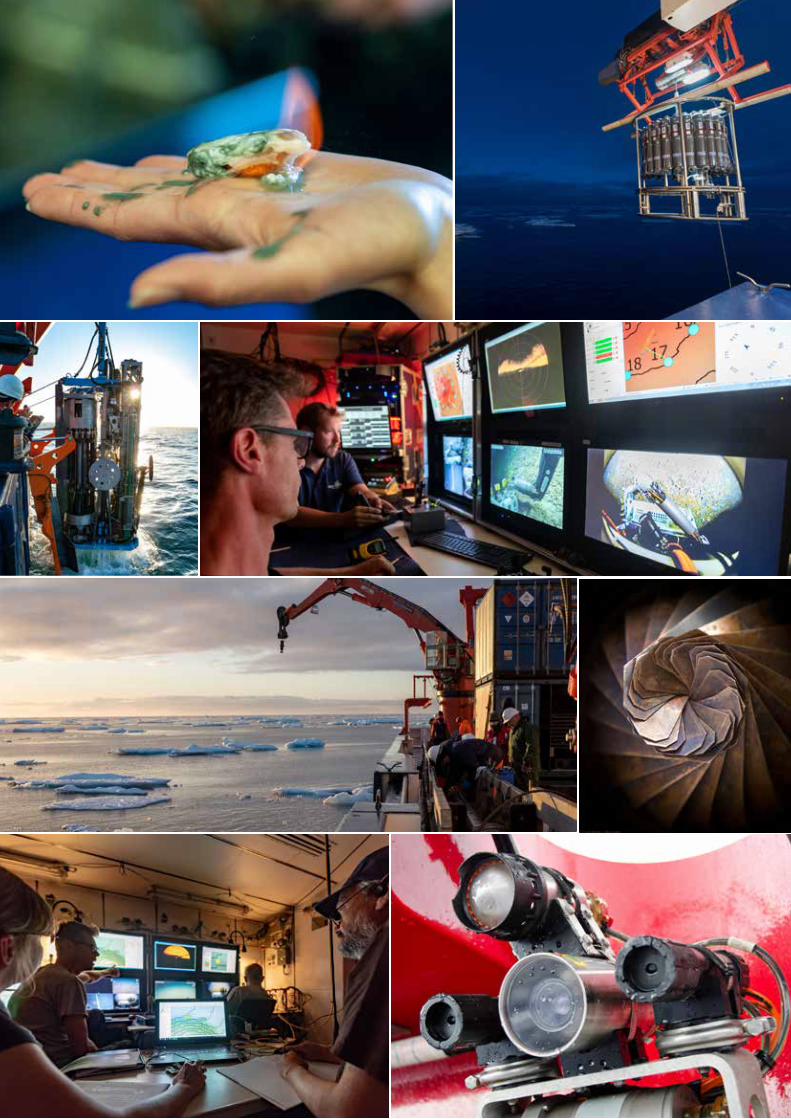
Exploration of the oceans requires the deployment of high-tech tools from research vessels.

6 – 7
among the factors that make the marine environment a central element in the Earth system. The oceans have an average depth of 3,700 meters and are distributed around the world. They also ac-commodate diverse ecosystems that are adapted to the prevailing environmental conditions. The deep ocean and the ocean floor are still widely unknown because direct measurements have only been sporadically carried out. But it is unquestionable that these regions fulfill important functions for the entire Earth system.
Due to global challenges such as climate change, sea-level rise, energy production from the seas, and the increasing interest in
resources found in the oceans, marine research is being con-fronted with new tasks of great societal importance. This is reflected by the marine research program of the federal govern-ment, ‘MARE:N — Coastal, Marine and Polar Research for Sustain-ability’, as well as the sustainabil-ity goals of the United Nations. Goal 14 in particular, to ‘conserve and sustainably use the oceans, seas and marine resources for sustainable development’, explic-itly addresses aspects directly related to the deep ocean. For example, the long-term capacity of the ocean to absorb carbon dioxide and the availability of raw materials in the sea both depend on processes in the deep ocean.
However, we still know too little about the processes in the deep sea to provide all the answers necessary for appropriate action.
MARUM produces fundamental scientific knowledge about the role of the ocean and the sea floor in the total Earth system. The dynamics of the oceans and the seabed significantly impact the entire Earth system through the interaction of geological, physical, biological and chemi-cal processes. These influence both the climate and the global carbon cycle, resulting in the creation of unique ecological systems. MARUM is committed to fundamental and unbiased re-search in the interests of society
“MARUM stands for
research, education
and the transfer of
knowledge for a
responsible approach
to the ocean.”Prof. Dr. Michael SchulzDirector of MARUM

and the protection of the marine environment.
Since its foundation, the research center MARUM — Center for Marine Environmental Sciences, has developed into an interna-tionally recognized facility for marine research that is firmly anchored at the University of Bremen. Since 2012, the Center has had the unique distinction of
Research in Bremen (ZMT), and with the University of Oldenburg and the private Jacobs University in Bremen.
MARUM is the home of the Cluster of Excellence ‘The Ocean Floor — Earth’s Uncharted Interface’ and other national and international research projects.
being the only Research Facul-ty of the University of Bremen. Through MARUM, the University of Bremen cooperates closely with the Alfred Wegener Institute, Helmholtz Center for Polar and Marine Research in Bremerhaven (AWI), the Max Planck Institute for Marine Microbiology in Bremen (MPI), with Senckenberg by the sea in Wilhelmshaven (SGN), the Leibniz Centre for Tropical Marine
The ROV MARUM-Squid being tested in the pool at MARUM prior to its next mission.
The laboratory infrastructure at MARUM provides ideal conditions for state-of-the art research.
Maintenance work on the MARUM-MeBo70
8 – 9
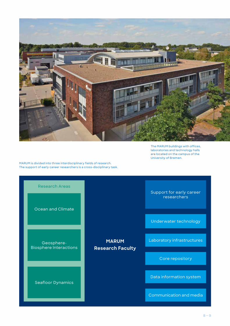
MARUM is divided into three interdisciplinary fields of research. The support of early career researchers is a cross-disciplinary task.
The MARUM buildings with offices, laboratories and technology halls are located on the campus of the University of Bremen.
MARUM
Research Faculty
Research Areas
Underwater technology
Laboratory infrastructures
Core repository
Data information system
Communication and media
Support for early career researchers
Ocean and Climate
Geosphere- Bio sphe re Interactions
Seafloor Dynamics
Research Area
Ocean and ClimateSediments deposited on the sea floor can be used to quantify past changes in the marine environment. The sea floor thus represents a unique archive for environmental changes at time scales of decades to millions of years. This archive significantly advances our understanding of many natural processes that are relevant for humanity and that to a large extent determine the present state of the Earth system and its future development. In addition to the classical methods of marine geology, isotope geochemical analyses of organic and inorganic components, in particular, are used to reconstruct environmental changes and to analyze the underlying processes.
Additionally, materials carrying evidence of the terrestrial climate are transported by winds and rivers into the ocean and preserved there. Deep-sea sediments therefore comprise an integrated climate archive that makes it possible not only to identify variations in the marine environment, but
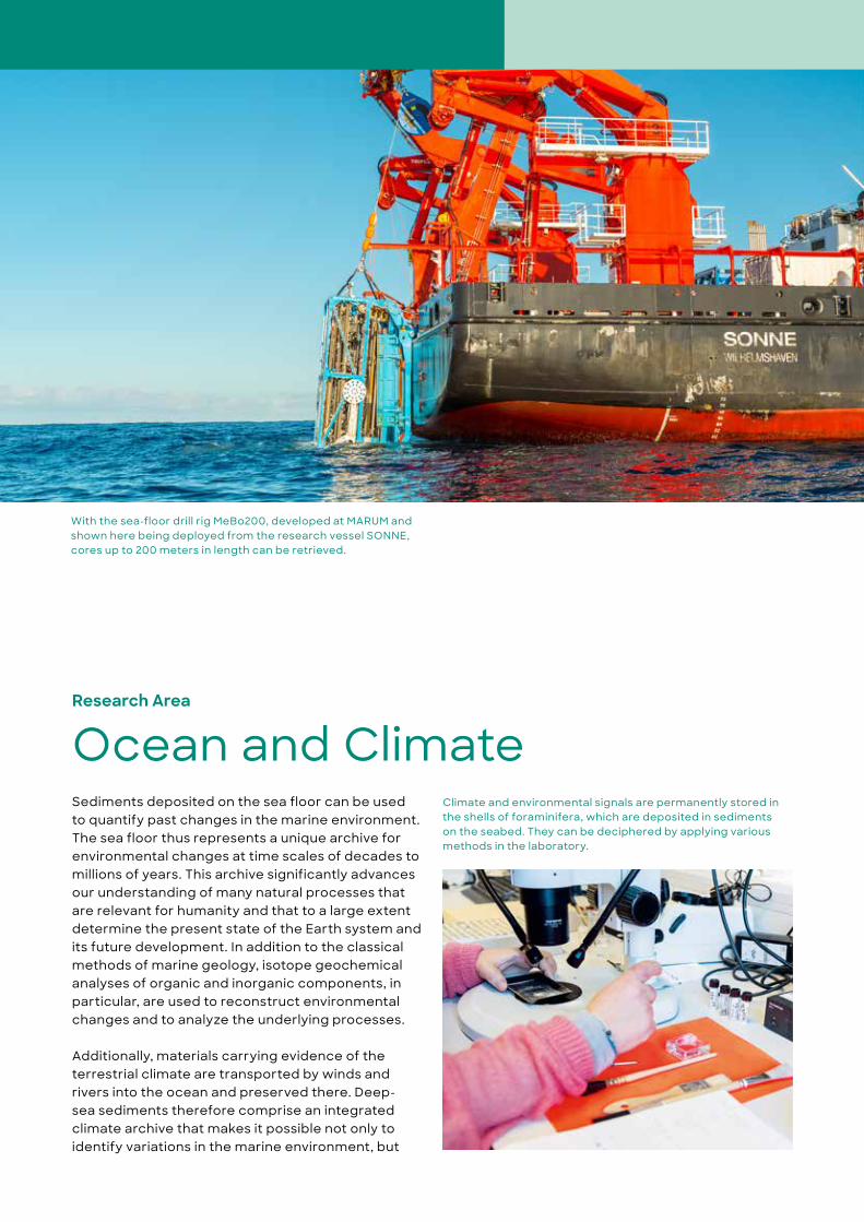
With the sea-floor drill rig MeBo200, developed at MARUM and shown here being deployed from the research vessel SONNE, cores up to 200 meters in length can be retrieved.
Climate and environmental signals are permanently stored in the shells of foraminifera, which are deposited in sediments on the seabed. They can be deciphered by applying various methods in the laboratory.

10 – 11
also to recognize contemporaneous changes on the continents as well as relationships between the two. These paleoceanographic and paleoclima-tological studies make it possible, for example, to draw conclusions about changes in global ocean currents and biological productivity, which are of great importance for the functioning of the climate system. Particular examples include heat transport, carbon-dioxide storage, and shifts in the regions of precipitation.
Direct measurements of physical parameters and trace gases in the sea, combined with remote satellite measurements, are used to investigate variations in currents and fluctuations in the ‘respi-ration’ of the deep ocean on time scales of months to decades. Using sediments with high temporal resolution and coral skeletons, it is possible to study the ocean’s role in climate processes at very de-tailed time scales covering periods of time for which direct measurements are not possible. Here, the role of amplification mechanisms, the interactions between climate subsystems, as well as the driving factors and the extent of possible local environmen-tal changes, are of particular importance.
There are many climate indicators in paleoclimatolo-gy that allow direct comparisons with the results of climate models. Such comparisons make it possible to test the quality of the models for future climate conditions and further improve the models. Toward this end, even more comprehensive paleoclimato-logical data sets will be needed in the future, and these will allow even greater detail in describing the past climate conditions.
With a weight of several tons, a gravity corer can sample the seabed to a depth of about 20 meters.
Recovery of a current meter moored in the ocean and installed in a flotation sphere. The current meters are deployed at differ-ent water depths for a year or longer and measure the current speeds and directions. These data provide evidence about fluctuations in the strength of ocean currents that is important for climate research.
Simplified circulation scheme of the North Atlantic. Red: warm surface water, blue: cold deep water.

Geological processes occurring beneath the sea floor create extreme habitats that are characterized by unique ecosystems. At mid-ocean ridges, hot fluids with temperatures up to 400 degrees Celsius move upward through the ocean crust. These fluids are rich in reduced chemical compounds and when they contact oxygenated seawater, they produce a bountiful source of energy for microorganisms and thus create a basis for the prolific communities at ‘hot vents’. Similarly, life also flourishes at ‘cold seeps’ on the continental margins and in marginal seas, where tectonic or geochemical processes release fluids enriched in methane and other gases along with organic compounds.
By contrast, the floor beneath the deep sea, where sediments are slowly deposited over long geological time periods, is generally characterized by extreme-ly low levels of energy. Nevertheless, it offers the living conditions required by microbial communities (known as the deep biosphere) and is estimated to contain as much microbial biomass as all the waters of the oceans. Even after drilling to depths of thou-sands of meters into the sea floor, the lower bound-ary of the deep biosphere has not yet been discov-ered. Furthermore, we still have only a rudimentary understanding of the processes and adaptations that make life possible under high temperature and pressure conditions with unusual energy sources, or even where there is a definitive lack of energy.
Research Area
Geosphere-Biosphere Interactions
Sampling gas from a cold seep using the submersible robot MARUM-quest

Many unique habitats on the sea floor and below have been extensively documented over the past 40 years. The systems already known, however, are only partially understood, and new ones are constantly being discovered. While there is no question that the processes taking place in global material cycles play a crucial role, concrete quantifications of material fluxes have so far been limited to rough estimates.
The existence of life under the extreme environ-mental conditions of the deep sea highlights the fact that we do not yet understand the limiting environmental factors that are ultimately in play for life on Earth — not to mention its possible presence on other planets. Our awareness that the extreme habitats of the deep sea exhibit great diversity does not obscure the fact that our knowledge regarding the stability or instability of these ecosystems is still very limited. The vulnerability of such systems to disturbances — especially the extraction of resourc-es from the seabed, carbon dioxide sequestration, fishing, and the influx of microplastics — cannot yet be reliably assessed.
Chemosynthetic biological communities in the Logatchev hydrothermal field on the Mid-Atlantic Ridge at a water depth of 3,000 meters
In the Gulf of Mexico, beard worms colonize asphalt layers that are formed at the sites of natural oil seeps at a water depth of 3,300 meters.
Measuring instruments deployed by a submersible robot auton-omously record oxygen consumption on bacterial mats in the oxygen minimum zone; here at a water depth of 1,100 meters on the continental margin of Pakistan.
Hydrothermal seeps in 860 meters of water in the Menez Gwen hydrother-mal field southwest of the Azores
12 – 13
Sediments transported from the continents by winds, rivers and glaciers may be deposited on the sea floor with thicknesses of several kilome-ters. At the mid-ocean spreading centers in the deep sea, magma rises from the Earth’s mantle and solidifies, forming new ocean crust and a worldwide underwater mountain chain with a total length of about 60,000 kilometers. Through the
cycle of plate tectonics, this ocean crust is even-tually subducted beneath the continents at the deep-sea trenches, where it submerges into the deep mantle and melts again.
The newly formed, hot ocean crust interacts chemically and physically with seawater. Cooling and aging processes produce small fissures in the
Research Area
Seafloor Dynamics
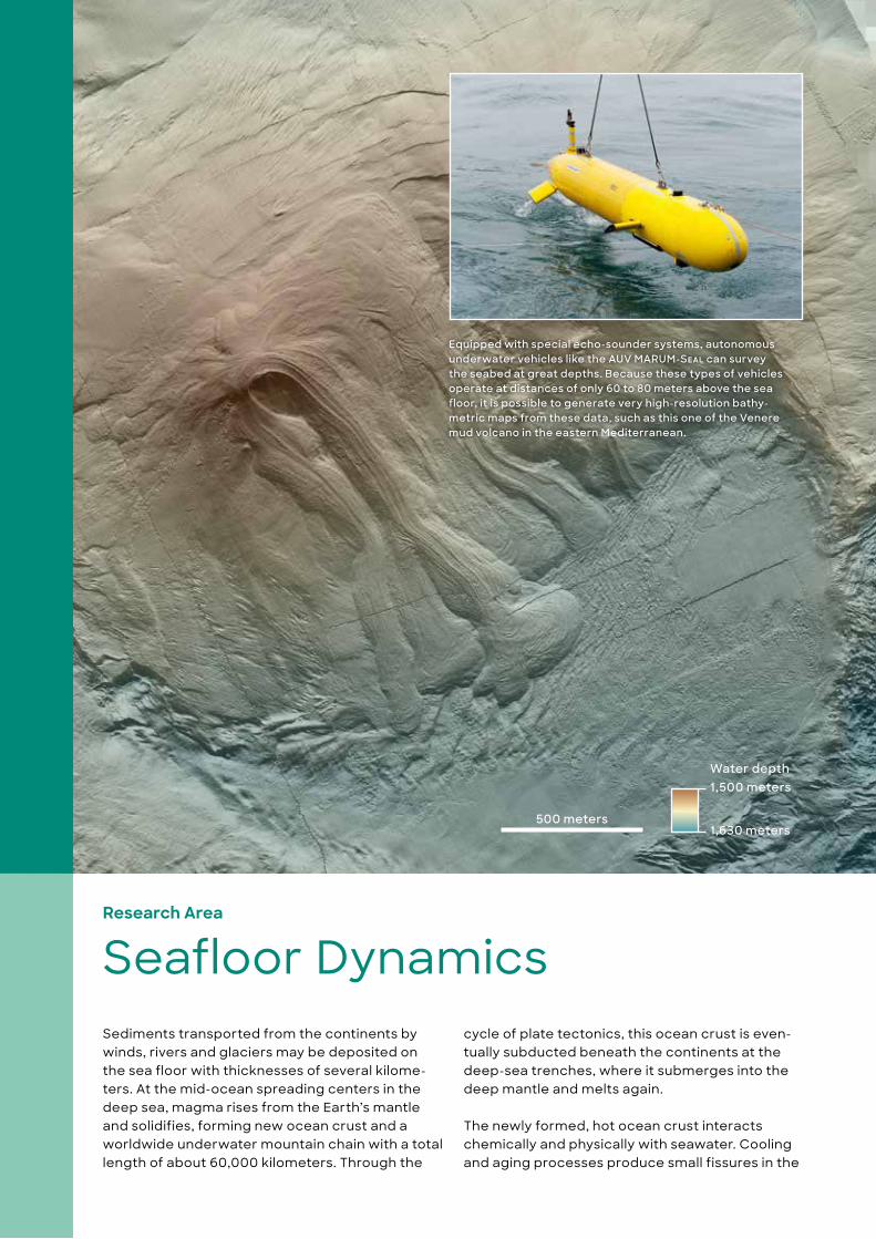
500 meters
Water depth1,500 meters
1,630 meters
Equipped with special echo-sounder systems, autonomous underwater vehicles like the AUV MARUM-Seal can survey the seabed at great depths. Because these types of vehicles operate at distances of only 60 to 80 meters above the sea floor, it is possible to generate very high-resolution bathy-metric maps from these data, such as this one of the Venere mud volcano in the eastern Mediterranean.
14 – 15
Research Area
Seafloor Dynamics
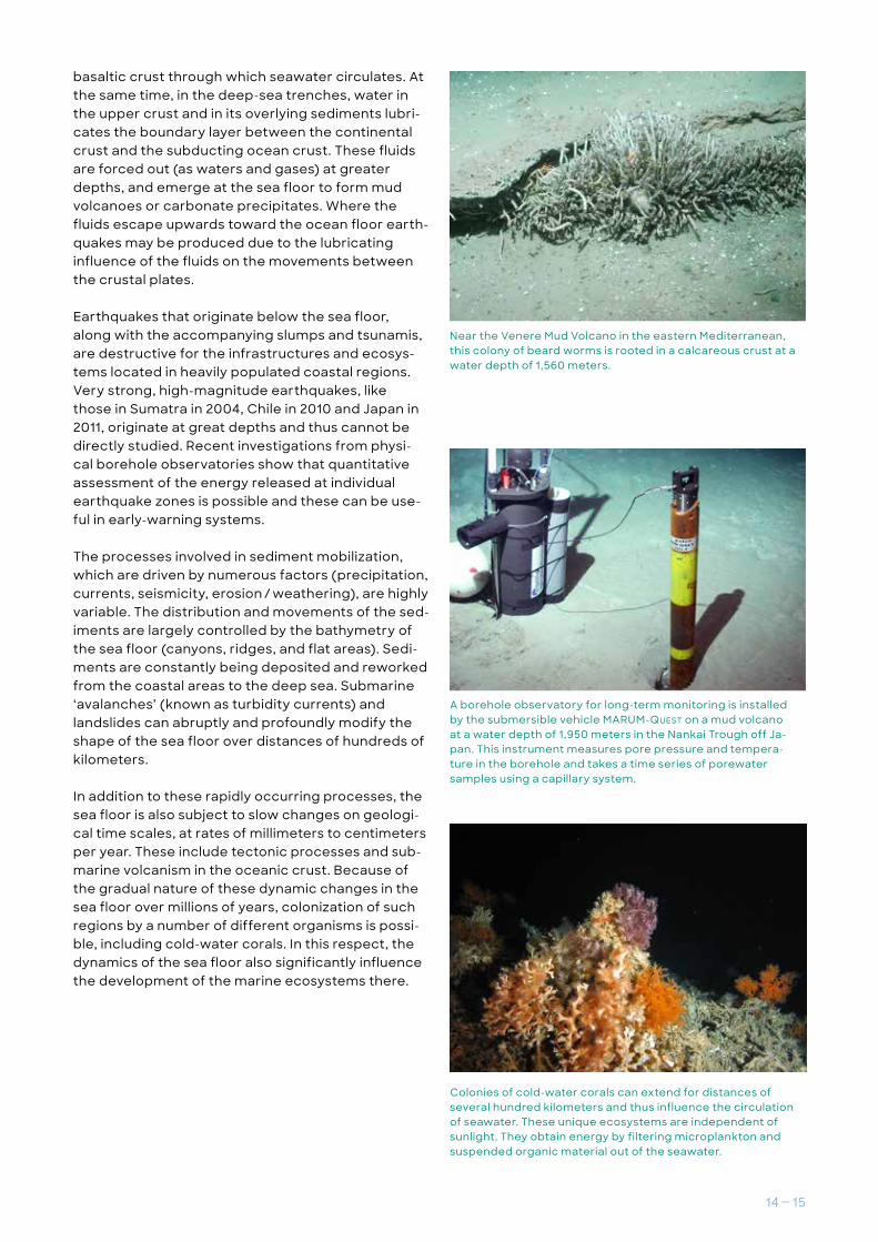
Near the Venere Mud Volcano in the eastern Mediterranean, this colony of beard worms is rooted in a calcareous crust at a water depth of 1,560 meters.
basaltic crust through which seawater circulates. At the same time, in the deep-sea trenches, water in the upper crust and in its overlying sediments lubri-cates the boundary layer between the continental crust and the subducting ocean crust. These fluids are forced out (as waters and gases) at greater depths, and emerge at the sea floor to form mud volcanoes or carbonate precipitates. Where the fluids escape upwards toward the ocean floor earth-quakes may be produced due to the lubricating influence of the fluids on the movements between the crustal plates.
Earthquakes that originate below the sea floor, along with the accompanying slumps and tsunamis, are destructive for the infrastructures and ecosys-tems located in heavily populated coastal regions. Very strong, high-magnitude earthquakes, like those in Sumatra in 2004, Chile in 2010 and Japan in 2011, originate at great depths and thus cannot be directly studied. Recent investigations from physi-cal borehole observatories show that quantitative assessment of the energy released at individual earthquake zones is possible and these can be use-ful in early-warning systems.
The processes involved in sediment mobilization, which are driven by numerous factors (precipitation, currents, seismicity, erosion / weathering), are highly variable. The distribution and movements of the sed-iments are largely controlled by the bathymetry of the sea floor (canyons, ridges, and flat areas). Sedi-ments are constantly being deposited and reworked from the coastal areas to the deep sea. Submarine ‘avalanches’ (known as turbidity currents) and landslides can abruptly and profoundly modify the shape of the sea floor over distances of hundreds of kilometers.
In addition to these rapidly occurring processes, the sea floor is also subject to slow changes on geologi-cal time scales, at rates of millimeters to centimeters per year. These include tectonic processes and sub-marine volcanism in the oceanic crust. Because of the gradual nature of these dynamic changes in the sea floor over millions of years, colonization of such regions by a number of different organisms is possi-ble, including cold-water corals. In this respect, the dynamics of the sea floor also significantly influence the development of the marine ecosystems there.
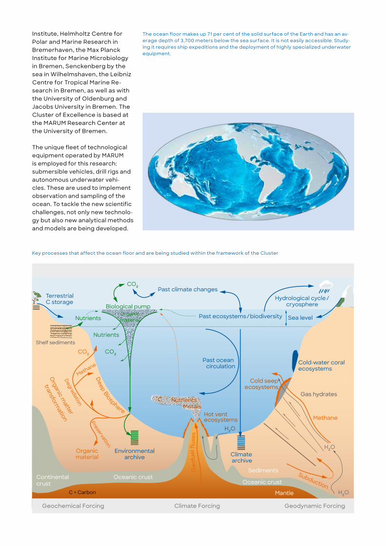
A borehole observatory for long-term monitoring is installed by the submersible vehicle MARUM-QueSt on a mud volcano at a water depth of 1,950 meters in the Nankai Trough off Ja-pan. This instrument measures pore pressure and tempera-ture in the borehole and takes a time series of porewater samples using a capillary system.
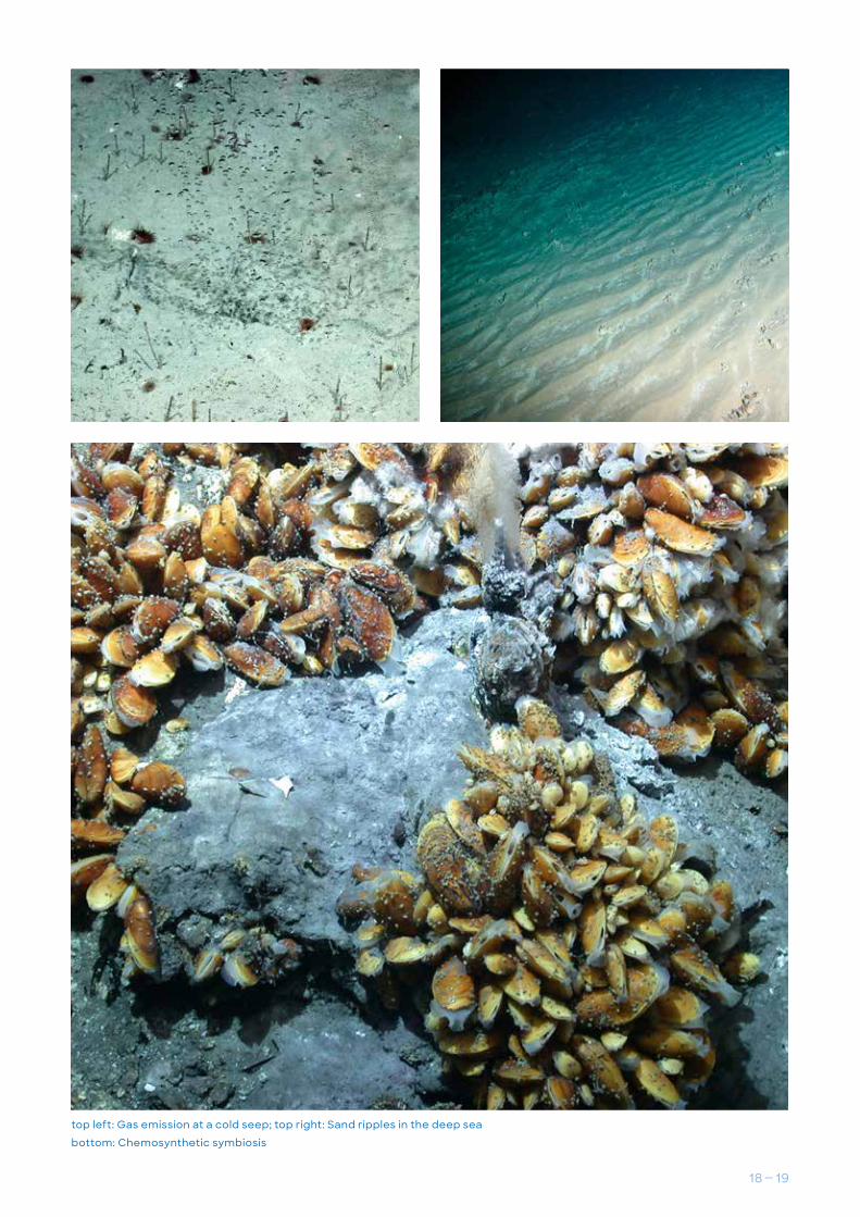
Colonies of cold-water corals can extend for distances of several hundred kilometers and thus influence the circulation of seawater. These unique ecosystems are independent of sunlight. They obtain energy by filtering microplankton and suspended organic material out of the seawater.

Cluster of Excellence at MARUM
The Ocean Floor — Earth’s Uncharted Interface
The ocean floor refers to the area of the seabed where the water depth is greater than 200 meters. This makes up the greater portion of the Earth’s solid surface, and it is also the interface at which geological, physical, chemical, biological and hydrological pro-cesses interact with one another.
Because of its immense total area, our knowledge about the factors that control the trans-port of organic materials to the ocean floor and thus influence the global carbon cycle and the climate system is gravely lacking. What happens when carbon and other elements produced by the
Bacterial mats in the Arabian Sea at a water depth of 730 meters

16 – 17
decomposition of organic mate-rial find their way into sea water or are released from the ocean floor into the water column? What is the fate of the countless types of plankton in the water column when they contact the ocean floor, and later at depth? The new Cluster of Excellence ‘Ocean Floor’ takes the initiative in this area, and researchers will concentrate exclusively on this still largely unexplored interface until 2025.
For about the past forty years it has been known that the deep sea is not a desert but rather an oasis of life, albeit a very delicate one. If the ecosystem is altered, it presumably would take decades to recover. There-fore, investigations in the Cluster also focus on how the sensitive ecosystems in the deep sea react to a changing environment and increasing water temperatures. Furthermore, the ocean floor is a unique archive that records the
environmental conditions of past times in its sediments.
The cluster aims to open a new chapter in ocean-floor research by quantitatively studying the exchange processes at this important interface as well as its role within the Earth system. To these ends the researchers in the Cluster are involved in close interdisciplinary cooperation with other institutions in the region, including the Alfred Wegener
Escaping methane bubbles at a carbonate chimney in the Black Sea, at a water depth of 260 meters
bottom: Basaltic ocean crust
top: Beard worms at a mud volcano
Institute, Helmholtz Centre for Polar and Marine Research in Bremerhaven, the Max Planck Institute for Marine Microbiology in Bremen, Senckenberg by the sea in Wilhelmshaven, the Leibniz Centre for Tropical Marine Re-search in Bremen, as well as with the University of Oldenburg and Jacobs University in Bremen. The Cluster of Excellence is based at the MARUM Research Center at the University of Bremen.
The unique fleet of technological equipment operated by MARUM is employed for this research: submersible vehicles, drill rigs and autonomous underwater vehi-cles. These are used to implement observation and sampling of the ocean. To tackle the new scientific challenges, not only new technolo-gy but also new analytical methods and models are being developed.
Geo
fuel
flux
es
CO²
Cold seepecosystems
Cold-water coralecosystems
Past ocean circulation
Sea levelPast ecosystems/biodiversity
Methane
H²O
H²O
Biological pump
Nutrients
Preservation
Gas hydrates
C
Climate archive
Environmentalarchive
Nutrients
H²O
DegradationHydrological cycle/
cryosphereTerrestrial C storage
Past climate changes
Continental crust
Oceanic crustOceanic crust
Sediments
Mantle
Shelf sediments
Deep Biosphere
Organic m
atter
Subduction
Hot vent ecosystems
C NutrientsMetals
Geochemical Forcing Geodynamic ForcingClimate Forcing
transformation
Organicmaterial
C = Carbon
CO²CO²
Methane
Organicmaterial
Key processes that affect the ocean floor and are being studied within the framework of the Cluster
The ocean floor makes up 71 per cent of the solid surface of the Earth and has an av-erage depth of 3,700 meters below the sea surface. It is not easily accessible. Study-ing it requires ship expeditions and the deployment of highly specialized underwater equipment.
18 – 19
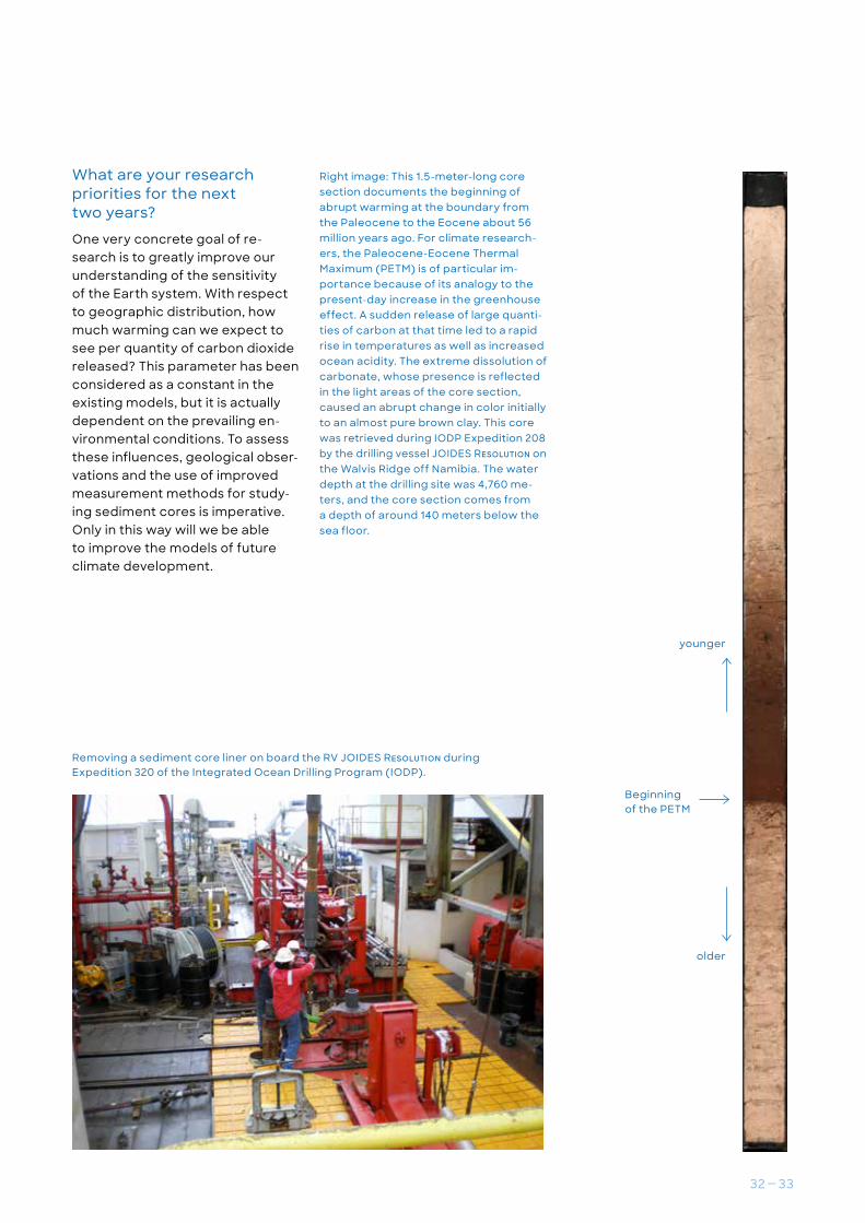
top left: Gas emission at a cold seep; top right: Sand ripples in the deep sea
bottom: Chemosynthetic symbiosis

Strong perspectives Promoting young talent
The training of early-career researchers has a long and valued tradition at MARUM. Doctoral students and postdocs here, presently from more than 30 countries, are motivated by a stimulating work environment that is designed to support them in all areas of their academic endeavors and through all stages of their careers.
It is possible for PhD students to become members of the Bremen International Graduate School for Marine Scientists (GLOMAR), which is hosted by MARUM. With the support of a team of experienced scientific advisors, GLOMAR offers the doctoral stu-dents ideal training conditions as well as the import-ant international and interdisciplinary networks that are crucial for advancing their careers.
MARUM offers its early-career researchers a variety of introductory and specialty courses that are tai-lored to their particular scientific disciplines, focus on interdisciplinary aspects, or contribute to the further development of personal skills. To this end, we work very closely with the relevant programs of our university and non-university partner institutes. This results in a regionally tailored and thematically very diversified continuing education program for early-career researchers.
With programs for individual mentoring, mutual support, sharing of best practice approaches in the supervision of students and doctoral candidates, and with career advice, postdocs are greatly sup-ported on their paths to academic independence.

20 – 21
Because early- career researchers often decide to pursue non-academic careers, many of the offered programs focus on this aspect of professional possi-bilities. This effort also counts on the involvement of our constantly growing group of MARUM alumni.
Although the numbers of male and female doctor-al students in the graduate programs are roughly equal, the proportion of women declines at more advanced career stages. In order to sustainably reduce this imbalance and to support women sci-entists in successfully continuing their academic careers, MARUM, in cooperation with the university program ‘navigare’, has been offering a successful mentoring program for young female scientists for many years.
Through their participation in all the decision-mak-ing bodies of MARUM, the early-career researchers not only gain insights into academic autonomy, they also actively participate in MARUM’s research plan-ning and in the continuing development of training concepts for young scientists.
With its unique infrastructure, MARUM is also a much sought-after partner for international cooperation in the development of promising young researchers. This is exemplified by the International Research Training Group ArcTrain, in which 12 German and 21 Canadian PhD students are studying climate-related environmental changes in the Arctic.
The PhD student community since 2006
Success rate:> 81 %
Duration of PhD phase: 3.7 yrs
Gender balance:63 % : 37 %
Internationals:48 %
> 60 % of Alumni stay in academia
MARUM offers PhD students and postdocs ideal conditions and an inspiring environment.


22 – 23
Everything under controlMarine technology at MARUM
For more than 25 years MARUM has been deploying high-technology tools that are crucially important for scientific investigations of the ocean floor. Ob-servations and measurements of the ocean floor are carried out directly in situ with remote-controlled and autonomous underwater vehicles, drill rigs and other instruments that can be deployed from research vessels. Worldwide, only a few institutions have fleets of modern underwater tools for ocean-floor research comparable to those at MARUM. Some of the equipment used is available on the open market, but MARUM also develops its own nov-el technology. In 2003, MARUM was the first facility in Germany to deploy a cable-attached and there-fore remotely operated vehicle (ROV) for deep-sea research. Attached high-resolution cameras docu-ment their surroundings in very high quality. Guided by video cameras, the manipulator arms of the sub-mersible vehicle obtain samples or install measuring devices at optimal locations for experiments on
the ocean floor. The underwater systems presently include two ROVs with diving capabilities of 4,000 and 2,000 meters and an autonomous underwater vehicle (AUV) that can be deployed down to 5,000 meters. In addition, MARUM has broken new ground in seabed exploration with the development of two remote-controlled sea-floor drill rigs (MeBo70 and MeBo200). The MeBo200 system can be deployed at water depths to 2,700 meters and can drill as deep as 200 meters into the sea floor. MARUM’s heavy maritime equipment is operated and continuously refined by highly specialized technicians and engi-neers, and is also made available to other working groups in Germany and internationally.
left page from top to bottom and f.l.t.r.: A dive by the ROV (Remotely Operated Vehicle) MARUM-QueSt, which is sta-tioned at MARUM.
The ten-ton sea-floor drill rig MARUM- MeBo70 being deployed over the stern of the research vessel METEOR with the help of a specially designed launching frame.
Two pilots operate the submersible ve-hicle from a control container on board the research vessel.
MARUM-QueSt is brought on board after a dive.
A wave glider in operation
The submersible vehicle MARUM-Squid on the working deck of the RV Meteor
The upper 50 centimeters of the sea floor is electromagnetically mapped us-ing the multi-sensor benthic sled NeridiS, developed at MARUM.
Underwater systems with deployment depths to
5,000 m

The Alfred Wegener Institute, Helmholtz Centre for Polar and Marine Research (AWI), and MARUM together operate an infor-mation system in which research data from the Earth system and the environment are archived and published. Because the system strives to embody a holistic view of the Earth, it is named after the supercontinent PANGAEA, in which all of the Earth’s continents were united 200 million years ago. For more than 25 years, PAN-GAEA has assured the scientific
community of long-term and re-liable access to all data obtained through the exploration of our planet. This certified electron-ic library adapts and develops international standards for data publication, and blends seamless-ly into the world’s evolving data infrastructures. It integrates data into the established processes of scientific publication and sup-ports the users of data archives. The data is subject to an internal review process similar to that required for scientific articles in
professional journals, and can be cited by other scientists in their own work. PANGAEA can store any conceivable measured values from all disciplines of earth and environmental sciences — from the upper atmosphere to the deepest layers of the sea floor.
Orientation in a sea of data The Data Information System PANGAEA

24 – 25
from the scientific community
Measurement dataMeasurement seriesLong-term seriesObservationsExperiments
•••••
From ships, buoys, measure-ment instruments, planes, stations and laboratory instruments
•
1. Collection of data and descriptive data (metadata)PO4
O2
CO2
NO3
Evaluate quality of the meta-data for completeness and reproducibility Conform formats and descriptionsFill gaps (in cooperation with producer of data) for the purpose of reuse or further use
•
•
•
2. Making the data useful
Structured data storageAssure permanent accessto data and metadataPrevent loss of, or changesto data
••
•
3. Archiving the data
Tag data with an international, permanent and unique identifier (DOI)Ensure reusability and facilitate citationMake data searchable by sharing the metadata with other portals and systems such as Google
•
•
•
4. Making the data accessible
400,000data sets
Additional tasks• Training scientists in the area of research-data management• Active support and guidance of scientists in research-data management in
institutions and in projects• Continuing development of standards for the exchange (interoperability) and
integration of data in cooperation with national and international initiatives
Project development and management• National research-data infrastructure (NFDI)• German Federation for Biological Data (GFBio e.V.)• German Network for Bioinformatics Infrastructure (de.NBI)
The graphic illustrates the workflow in PANGAEA from the collection of data to making it available on the network.


26 – 27
Exposing the invisibleThe Laboratory Infrastructure at MARUM
MARUM is equipped with a wide range of state-of-the-art analytical instruments. These tools have the ability to reveal important environmental information preserved in minerals and organic molecules, and in the isotopic compositions of organic and inorganic substances. The materials analyzed include calcar-eous fossils as well as other rocks and sediments. Additionally, water samples from the ocean and in the pore spaces of sediments are investigated. These analyses provide insights into the sources and histories of the rocks, the transformation processes operating on the organic materials and the micro-bial communities involved, as well as the changes in environmental conditions and ecosystems through-out Earth’s history. The infrastructure for chemical analyses includes a number of key high-performance instruments and specialized laboratories:
• ultra-high-resolution mass spectrometry for the analysis of complex molecular compositions in marine environmental samples, such as the dissolved organic components in the sea
• comprehensive analysis of complex microbial lipids in marine and sediment samples
• several specialized laboratories for highly precise isotope analyses of light to heavy elements
• ultra-high-resolution temporal records of biomarkers in marine sediments for climate reconstruction
• geochemical mapping of element distributions in the micrometer range in rocks and sediments
In order to understand how environmental condi-tions influence isotope ratios and material cycles, MARUM also operates gene and culture laboratories for marine algae. These are essential for studying the diversity of these organisms and their growth with respect to climate changes under controlled conditions.
With its infrastructure, combined with the regional and inter-national networking, the MARUM Research Faculty offers PhD students and postdocs the ideal conditions for their research.

Of the three International Ocean Discovery Program (IODP) core repositories worldwide, the largest is housed at MARUM. This important research program brings together scientific institutions from 23 coun-tries, including the United States, Japan and a con-sortium of European countries, to carry out expedi-tions that drill into the sea floors around the world using drilling ships and platforms. More than 250,000 core sections, the first of which were retrieved in 1968, are stored in the Bremen IODP facility. They come from the Atlantic and Arctic Oceans and the Mediterranean, Black and Baltic Seas. Each year, around 200 scientists visit the Bremen IODP Core Repository to study this unique sample material,
Over 158 kilometers of sea floor The Bremen IODP Core Repository

28 – 29
while others request specific sets of samples to be sent to them. A total of around 50,000 samples are sent out annually. Germany and 14 other mem-ber countries comprise the European drilling con-sortium ECORD. It carries out IODP expeditions in marine regions that the larger IODP drilling ships are not able to access. These include the ice-covered waters of the Arctic Ocean and shallow coastal or inland seas. For these expeditions using specialized ships or drilling platforms, MARUM provides the mo-bile laboratory containers for microscopic analyses, geochemical measurements, and microbiological sampling. The samples from these expeditions are stored in Bremen.
200 scientists visit the Bremen Core Repository each year
250,000 plastic liners stored in the five-and-a-half meter high shelves of the Bremen Core Repository contain ocean-floor cores of inestimable value for science, the fruits of more than 50 years of international drilling expeditions. Each of the core segments is one-and-a-half meters long and has a diameter of about seven centimeters.
Over 158 kilometers of sea floor The Bremen IODP Core Repository

Climate change is posing increasingly great challeng-es for humanity. To assess its future development, a thorough understanding of the Earth’s complex cli-mate system is essential. A glimpse into the past helps researchers in this respect. Reconstructions of paleocli-mate help us to understand how the system reacts to changes. This knowledge is then also used in calculations for modeling various future scenarios. At MARUM, scien-tists from multiple disciplines are researching this field. One of these is Heiko Pälike, head of the paleoceanogra-phy working group.
How can a view into the past lead to a better under-standing of Earth’s climate system?
Throughout the course of Earth’s history climate has been con-stantly changing, but the changes caused by human influences are proceeding much more rapidly than ever before in the past. An important part of our research is to assess how the climate system has responded to these kinds of changes, for example, to differ-ent levels of greenhouse-gas concentrations. Climate archives from the geological past help us to investigate how climate condi-tions could change in the future. The climate system of the Earth is presently in a very delicate state of balance, but we are now in the process of hurriedly tweaking some of the adjustment screws, and the changes being observed cannot be explained without invoking human influence. For ex-ample, the extremely rapid input of carbon dioxide into the atmo-sphere not only leads to warming, it also increases the solubility of
carbonates in the ocean. In the past, this has caused difficulties in the adaptive capability of some marine organisms. It is not clear to what extent and how quickly animal and plant habitats, the foundations of our environment, can adapt to such a rapidly chang-ing climate system in the future. Many of the parameters applied in climate models still need to be calibrated on the basis of obser-vations and measurements. This is only possible through the climate archives of the geologic past.
How do researchers study climate conditions that exist-ed millions of years ago?
Sediment deposits contain mi-crofossils and other measurable features that, under ideal condi-tions, provide an archival record of climate history. One aspect of our research involves deciphering of this climate archive. Sediment thicknesses of one or two centi-meters in the deep ocean floor represent a time period of about 1,000 years. In practical terms, we work with the fossil shells
Paleoclimate research at MARUM
Learning from the past, for the future

30 – 31
of organisms whose properties were influenced in some way by various environmental factors at the time of their formation. One example is the temperature at different water depths, which can be reconstructed for the past by examining the shells of marine or-ganisms known to have lived with-in particular depth intervals. The Earth System reacts sensitively to changes in the greenhouse-gas budget, which determines the intensity of Earth’s warming.
Is there a convincing exam-ple of a sudden release of greenhouse gases in Earth’s history, and what does science know about it? As a result of a sudden (by geo-logical standards) warming about 56 million years ago, the flora and fauna were drastically altered, especially in the ocean. During the Eocene, from 56 to 35 million years ago, the temperature of deep-ocean water was around ten degrees Celsius warmer than it is today. Researchers are in agreement that the temperature increase at the beginning of the
Eocene was caused by the re-lease of large quantities of carbon from the ocean floor. Because of the analogy with the present-day temperature increase related to the greenhouse effect, many scientific studies are looking at this event in the past in order to better understand the situation and the impact on the environ-ment today. The total amount of carbon released 56 million years ago, as estimated by various meth-ods, corresponds roughly to the amount that has been released as carbon dioxide since the begin-ning of the industrial era. We have thus achieved these comparable amounts in a much shorter time period, at rates between ten and 100 times as fast. Furthermore, the warming was associated with far-reaching effects on physical, geochemical and biological pro-cesses. This resulted in reduced temperature gradients between the equator and the poles, a weak-ening of the wind system, chang-es in ocean circulation, reduced oxygenation, enhanced ocean acidification, and a decrease in nutrients in the ocean.
Considering the difference in boundary conditions, can the situation in the past be compared with the present? In the past, of course, the distribu-tion of continents and the ocean circulation were different from to-day. However, many of the relevant processes were based on physical and chemical principles that are as true now as they were then. The distribution and size of ice sheets in the Arctic and Antarctic, for ex-ample, were different, so it is not possible to make completely accu-rate predictions based on geo-logical observations alone. But, in
“We are working to im-
prove climate models
even more”Prof. Dr. Heiko PälikeHead of work group Paleoceanography

principle, we understand very well how to use the events from that time to improve our understand-ing of future climate. The research results of the geologic past are simulated using climate models in order to understand important processes in our climate system, and to calculate possible future climate scenarios. One aspect that has not yet been sufficiently studied is the extent to which or-ganisms react to climate changes. We have quite a good overview of which organisms lived in the sea at that time. But one of our research
goals is to understand their func-tions within the ecosystem, and how quickly living organisms are able to adapt to changing environ-mental conditions.
Moreover, situations can arise in the climate system where irre-versible changes suddenly occur that are further amplified by feed-back mechanisms. For example, warming leads to the melting of ice and the melting to a reduced albedo, which causes an increase in warming. This, in turn, facilitates the release of the greenhouse gas
methane, which further amplifies the initial warming. These effects are known as positive feedback. There are, however, also some negative feedbacks in the Earth system. For example, during peri-ods of elevated temperatures and carbon-dioxide values, the natural weathering of rocks is intensi-fied, which ultimately leads to the removal of carbon dioxide from the atmosphere and ocean, and its deposition as carbonate in the deep sea. This process, however, requires time frames of over a million years.
−100
0
100
0
5
10
20
25
30
0102030405060
100
1,000
10,000
1,000
10,000
0
15
0
5
10
1515
20
25
30
1800 2000 2200
100
400400
0102030405060 1800 2000 2200
RCP8.5
?
RCP8.5
RCP8.5
2°C warmerPre-industrial
Greenhouse world Icehouse world
YearAge (millions of years ago)
ArchivesObservations and modeling
2017
Pre- industrial
PETM Atmospheric CO²
Global sea level
Global surface temperature
Sea
leve
l (m
)Te
mpe
ratu
re (°
C)
CO
² (ppm
V)
Global deep ocean temperature
Present day RCP8.5
Simplified representation of the reconstruction of various climate indicators covering the past 66 mil-lion years, and comparison with a future scenario
32 – 33
What are your research priorities for the next two years?
One very concrete goal of re-search is to greatly improve our understanding of the sensitivity of the Earth system. With respect to geographic distribution, how much warming can we expect to see per quantity of carbon dioxide released? This parameter has been considered as a constant in the existing models, but it is actually dependent on the prevailing en-vironmental conditions. To assess these influences, geological obser-vations and the use of improved measurement methods for study-ing sediment cores is imperative. Only in this way will we be able to improve the models of future climate development.
Right image: This 1.5-meter-long core section documents the beginning of abrupt warming at the boundary from the Paleocene to the Eocene about 56 million years ago. For climate research-ers, the Paleocene-Eocene Thermal Maximum (PETM) is of particular im-portance because of its analogy to the present-day increase in the greenhouse effect. A sudden release of large quanti-ties of carbon at that time led to a rapid rise in temperatures as well as increased ocean acidity. The extreme dissolution of carbonate, whose presence is reflected in the light areas of the core section, caused an abrupt change in color initially to an almost pure brown clay. This core was retrieved during IODP Expedition 208 by the drilling vessel JOIDES ReSolution on the Walvis Ridge off Namibia. The water depth at the drilling site was 4,760 me-ters, and the core section comes from a depth of around 140 meters below the sea floor.
Beginning of the PETM
younger
older
Removing a sediment core liner on board the RV JOIDES ReSolution during Expedition 320 of the Integrated Ocean Drilling Program (IODP).

Landslides occur not only on land, but also in ma-rine regions comprising soft sediments. These are common on the continental margins and slopes, but also include fjords, river deltas, volcanic islands and marine ridges. The underwater landslides, however, can be many times as large as those on land. When the ground beneath the surface of the sea starts to move it can involve thousands of square kilometers of ocean floor. The international training network SLATE, funded by the European Commission and
European funding for research on submarine landslides
Interdisciplinary training in the european network SLATE
coordinated by MARUM, is examining the causes and effects of these kinds of events.
SLATE stands for Submarine LAndslides and Their impact on European continental margins. The network was established in 2017 and it is funded through the Marie Skłodowska-Curie (MSC) pro-gram. The shifting masses of material and the energy released by landslides can trigger tsunamis, which are a threat not only to the coastal regions
Annual thematic workshops are an important element of the training program. As part of the second meeting geophysical and geotechnical methods were used to measure various land-slides, and sediment cores were taken.

34 – 35
of Europe, but also to infrastructures near, on and under the water. These can include, for example, production pipelines and communication cables.
Although submarine landslides have been inten-sively researched for decades, their causes, mech-anisms and consequences are still not thoroughly understood. What are the key factors that facilitate submarine landslides? How does the material contin-ue to move after it has slumped? And how can the resulting geohazards, such as tsunamis, be reliably predicted? Researchers in the European training network are addressing these questions. Working with multiple disciplines and diverse partners, their goal is to gain a better understanding of the pro-cesses preceding, during and after landslides. This includes examining the parameters that can drive and facilitate submarine landslides.
A team of leading researchers and specialists from prominent academic and non-academic institutes contribute comprehensive and interdisciplinary expertise. This pool of expertise encompasses the fields of marine geophysics, sedimentology, civil en-gineering, geotechnical engineering, offshore tech-nology, tsunami research and hazard assessment. A cohort of 15 early career researchers is trained and mentored across multiple disciplines.
“Combining complementary courses, field trips and joint annual workshops, this integrative approach is fostering a new generation of highly motivated and exceptionally qualified young scientists to address the challenges associated with landslide-related hazards,” explains the coordinator of the network, Prof. Katrin Huhn, in her assessment of the training.
Their research projects are based on modern methods and data sets. The data are derived from comprehensive, high-resolution and replicated ocean-bottom investigations, direct monitoring, state-of-the-art laboratory and in-situ measure-ments, and the latest modeling and process sim-ulation approaches. The early career researchers examine case and general studies and develop new models. “SLATE thus provides process-oriented knowledge and new expertise for assessing haz-ards — especially with regard to the controlling fac-tors and dynamics of underwater landslides,” contin-ues Katrin Huhn. It also considers how landslides can impact society and the economy.
“Our goal is to better
understand submarine
landslides in order to
minimize the geo-risks
associated with them.”Prof. Dr. Kat rin Huhn-Fre hersHead of work group Modelling of Sedimentation Processes
Three of the 15 total SLATE projects are currently being carried out at MARUM. In a laboratory-based generic study, Ting-Wei Wu is striving to quantify how earthquakes affect the stability of ocean-slope sediment deposits. For this purpose, she simulates seismic shaking, or earthquakes, on sediment sam-ples of different types and mineralogical composi-tions.
Ricarda Gatter, as an aspect of her PhD research, studies the importance of the layers that induce submarine landslides. For this, she uses macro- and microanalyses of sediment-core material from regions where landslides have occurred throughout the past millennia. Her goal is to create a new un-derstanding of the relationship between sediment structure and the physical properties of sea floor areas that slump, and thus determine what happens immediately prior to a landslide.
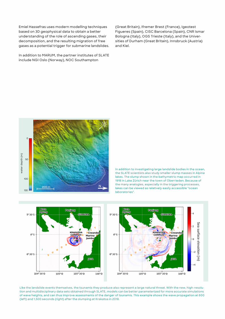
Emiel Hassefras uses modern modelling techniques based on 3D geophysical data to obtain a better understanding of the role of ascending gases, their decomposition, and the resulting migration of free gases as a potential trigger for submarine landslides.
In addition to MARUM, the partner institutes of SLATE include NGI Oslo (Norway), NOC Southampton
(Great Britain), Ifremer Brest (France), Igeotest Figueres (Spain), CISC Barcelona (Spain), CNR Ismar Bologna (Italy), OGS Trieste (Italy), and the Univer-sities of Durham (Great Britain), Innsbruck (Austria) and Kiel.
Like the landslide events themselves, the tsunamis they produce also represent a large natural threat. With the new, high-resolu-tion and multidisciplinary data sets obtained through SLATE, models can be better parameterized for more accurate simulations of wave heights, and can thus improve assessments of the danger of tsunamis. This example shows the wave propagation at 600 (left) and 1,500 seconds (right) after the slumping at Krakatoa in 2018.
In addition to investigating large landslide bodies in the ocean, the SLATE scientists also study smaller slump masses in Alpine lakes. The slump shown in the bathymetric map occurred in 1918 in Lake Zürich near the town of Oberrieden. Because of the many analogies, especially in the triggering processes, lakes can be viewed as relatively easily accessible “ocean laboratories”.
200 m N
0
50
100
130
Was
sert
iefe
[m]
wat
er
de
pth
(m)
36 – 37
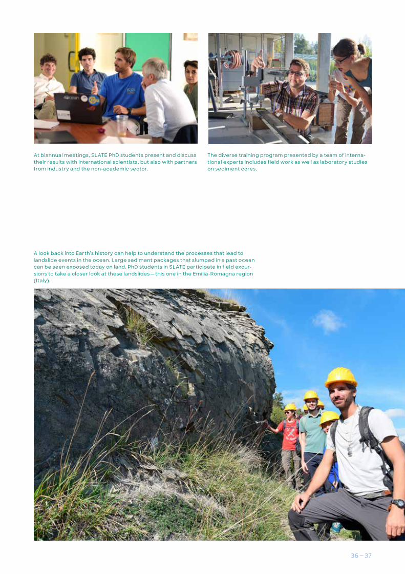
The diverse training program presented by a team of interna-tional experts includes field work as well as laboratory studies on sediment cores.
At biannual meetings, SLATE PhD students present and discuss their results with international scientists, but also with partners from industry and the non-academic sector.
A look back into Earth’s history can help to understand the processes that lead to landslide events in the ocean. Large sediment packages that slumped in a past ocean can be seen exposed today on land. PhD students in SLATE participate in field excur-sions to take a closer look at these landslides — this one in the Emilia-Romagna region (Italy).

There are many processes in the ocean that have not yet been scientifically explained. One of these, in particular, is the high-ly complex carbon cycle. The Marine Glycobiology research group, led by Prof. Dr. Jan-Hendrik Hehemann, which is housed both at MARUM and the Max Planck Institute for Marine Microbiology, investigates microalgae and their function within the carbon cycle. One important focus of the team is polysaccharide compounds and their role in the ocean eco-system.
Like plants on land, algae carry out photosynthesis in the sunlit upper water layers of the ocean, using carbon dioxide from the atmosphere as a building material for their growth. Microalgae in the surface waters produce a total amount of biomass similar to that
of all the terrestrial plants, in spite of the fact that they make up only a small proportion of the organ-isms living in this environment. This is because of their compar-atively short life spans. “Microal-gae live fast and die young,” says Jan-Hendrik Hehemann. Algae bloom within a period of days and then disappear soon thereafter. Microscopically small planktonic algae are the foundation of the marine food chain, upon which bacteria as well as larger animals feed.
When microalgae are active, they secrete polysaccharides, which sink through the water column to the ocean floor and transport carbon to the deep sea. The polysaccharides are thus a significant component of the “biological pump”, which is responsible for the transport of
Black box of the marine carbon cycleThe role of microalgae in the ocean ecosystem
Coscinodiscus wailesii are microalgae belong-ing to the family of diatoms that form algal blooms and produce significant amounts of long-chain sugars. The Marine Glycobiology research group studies the turnover and the role of these sugars in the carbon cycle.
38 – 39
carbon and carbon dioxide from the surface waters into the deep sea. The role of microalgae in this process is not yet understood in great detail. To address this ques-tion, Jan-Hendrik Hehemann’s research group studies the inter-actions between enzymes and sugar molecules. In their investi-gations of microalgae that live in the upper-ocean layer penetrat-ed by sunlight, Hehemann and his colleagues have employed a newly discovered enzyme. Their findings indicate that a large proportion of the algal biomass, an average of about one-fourth, is composed of the long-chain sugar molecule laminarin. The concentration of this molecule in the algal cells increases sig-nificantly over the course of the day, whereby the activity levels of algae vary at different times of the day. Quantitatively, around twelve gigatons of carbon are synthesized annually in the form of laminarin by algal photosynthe-sis. However, only a small portion of that is permanently removed from the atmosphere.
When diatoms die after the bloom, they sink toward the bottom. The researchers in the laminarin study discovered that this sugar molecule accounts for around half of the organic carbon in the sinking diatoms. “Laminarin thus plays an important role in the transport of carbon from the ocean surface to greater depths. Whether laminarin remains there over the long term is an import-ant question that we now have to address,” stresses Hehemann.
Most of the biomass that arrives from the surface into the deep ocean is recycled there. The remainder sequesters carbon in the marine sediments, thus regulating the concentration of oxygen and carbon dioxide in the atmosphere. As the particles sink downward, the long-chain sugar molecules act as a glue to hold the cells and mineral material together, causing the particles to become larger and denser, and thus to sink more rapidly. This ad-hesive apparently resists certain bacterial enzymes that would
otherwise cause it to dissolve and the particles to break down into their component parts.
Exactly how the adhesive func-tions, however, is not known. To find this out Hehemann and his colleagues have investigated which sugar compounds occur abundantly during an algal bloom. In the process, they also discov-ered an abundance of enzymes that are known for the degrada-tion of sugars like laminarin. By contrast, enzymes that break down long-chain, fucose-contain-ing sugars were absent. The latter wrap themselves around the particles like an antifouling mate-rial, protecting them from being degraded by bacteria. “Further-more, our results indicate that the algal sugar molecules that form the adhesive matrix of the cells and particles are stable, and could thus represent an as yet un-explored mechanism for carbon sequestration in the ocean.”
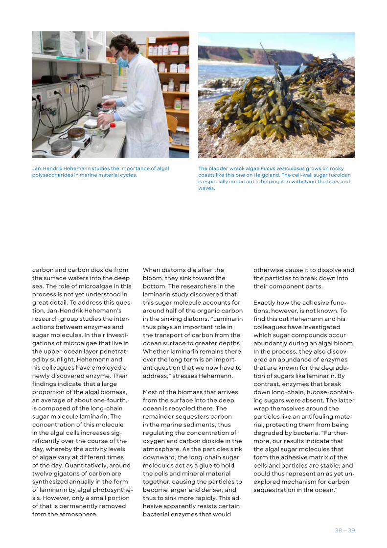
Jan-Hendrik Hehemann studies the importance of algal polysaccharides in marine material cycles.
The bladder wrack algae Fucus vesiculosus grows on rocky coasts like this one on Helgoland. The cell-wall sugar fucoidan is especially important in helping it to withstand the tides and waves.

Scheduled expeditonsExpeditons 2010 — 2019
Professorships 22 23%
Administration 19 100%
Personnel withinternational background 24% (all groups combined)
Personnel
Senior Scientists 53 30%Technical personnel 70
24%
Post-docs 70 41%
External funding
PhD Students 44 52%
Total 18.7
DFG 11.1
Federal Gov’t 3.4
EU 1.7
Other 2.5
Ship expeditions
Percent
Publicationswith international participation
2011 2012 2013 2014 2015 2016 2017 2018 2019
85
80
75
70
65
60
55
PhD graduates
2015 2016 2017 2018 2019 Total
14 21 35 14 20 104
17 / Jahr2015 — 2019 average(3 with IODP)
Associated personnel(partner institutes)
Senior Scientists 23 35%
Professorships 18 33%
(2015 — 2019 average, million Euros/year)
MARUM in numbers
Scheduled expeditonsExpeditons 2010 — 2019
Professorships 22 23%
Administration 19 100%
Personnel withinternational background 24% (all groups combined)
Personnel
Senior Scientists 53 30%Technical personnel 70
24%
Post-docs 70 41%
External funding
PhD Students 44 52%
Total 18.7
DFG 11.1
Federal Gov’t 3.4
EU 1.7
Other 2.5
Ship expeditions
Percent
Publicationswith international participation
2011 2012 2013 2014 2015 2016 2017 2018 2019
85
80
75
70
65
60
55
PhD graduates
2015 2016 2017 2018 2019 Total
14 21 35 14 20 104
17 / Jahr2015 — 2019 average(3 with IODP)
Associated personnel(partner institutes)
Senior Scientists 23 35%
Professorships 18 33%
(2015 — 2019 average, million Euros/year)

40 – 41
Scheduled expeditonsExpeditons 2010 — 2019
Professorships 22 23%
Administration 19 100%
Personnel withinternational background 24% (all groups combined)
Personnel
Senior Scientists 53 30%Technical personnel 70
24%
Post-docs 70 41%
External funding
PhD Students 44 52%
Total 18.7
DFG 11.1
Federal Gov’t 3.4
EU 1.7
Other 2.5
Ship expeditions
Percent
Publicationswith international participation
2011 2012 2013 2014 2015 2016 2017 2018 2019
85
80
75
70
65
60
55
PhD graduates
2015 2016 2017 2018 2019 Total
14 21 35 14 20 104
17 / Jahr2015 — 2019 average(3 with IODP)
Associated personnel(partner institutes)
Senior Scientists 23 35%
Professorships 18 33%
(2015 — 2019 average, million Euros/year)


42 – 43
About us
PublisherMichael Schulz MARUM — Center for Marine Environmental Sciences University of Bremen Leobener Straße 8, D-28334 Bremen, Germany +49 421 218 65500 [email protected]
TextsFrank Oliver Glöckner, Dierk Hebbeln, Jan-Hendrik Hehemann, Kai-Uwe Hinrichs, Katrin Huhn-Frehers, Christina Klose, Achim Kopf, Jannis Kuhlmann, Heiko Pälike, Ulrike Prange, Monika Rhein, Ursula Röhl, Frank Schmieder, Michael Schulz
TranslationWalter Hale, Bremen
PhotosTitle page, p. 5 (No. 1), p. 10 top: MARUM, Thorsten Klein. p. 4 (No. 1 — 7), 5 (No. 3), 6, 8 (3), 10 bottom, 11 top, 14, 20, 21 (3), 22 (No. 2 / 6), 24, 26 (2), 27, 28, 29 (2), 31 (kl.), 42 (No. 1/2), back cover: MARUM, Volker Diekamp. p. 4 (No. 8), p. 22 (No. 3 / 4), 42 (No. 3) Sean Diaz. p. 5 (No. 2): MARUM, Marcel Schröder. p. 7: Margit Wild. p. 9: MARUM, Albert Gerdes. p. 11 bottom: MARUM, Dagmar Kieke. p. 12, 13 (4), 15 (3), 16, 17 (3), 19 (3), 42 (No. 4/5): MARUM, ROV-Teams. p. 22 (No. 1): HYDRA, Christian Lott. p. 22 (No. 5): MARUM, Sebastian Meckel. p. 22 (No. 7): MARUM, Tilo von Dobeneck. p. 30 / 31: pxhere. p. 33 bottom: MARUM, Heiko Pälike. p. 33 right: MARUM / IODP, Ursula Röhl. p. 34, 37 (3): SLATE; p. 35: private. p. 38: Max Planck Institute for Marine Microbiology (MPI MM), Craig S. Robb. p. 39 left: MPI MM. p. 39 right: MPI MM, Mikkel Schultz-Johansen.
Graphicsp. 9, 18, 21, 32, 40 / 41: MARUM / Büro 7. p. 11: MARUM, Dagmar Kieke / Linn Sanguineti. p. 14 Map: after M. Loher, p. Ceramicola, P. Wintersteller, G. Meinecke, H. Sahling and G. Bohrmann (2018): Mud volcanism in a canyon: morphodynamic evolution of the active Venere mud volcano and its interplay with Squillace Canyon, Central Mediterranean. Geochemistry, Geophysics, Geosystems. doi:10.1002/2017GC007166. p. 25: MARUM / PANGAEA / GfG — Gruppe für Gestaltung, Bremen. p. 30: MARUM / Büro 7. Data modified and extended according to IPCC und Hansen et al. 2013 (Phil Trans R Soc A, doi:10.1098/rsta.2012.0294). Modeling of the sea level according to DeConto and Pollard 2016 (Nature 531, doi:10.1038/nature17145). Modeling of global deep water temperature from CMIP5-derived model ensembles for water depths > 3 kilometers (Giorgetta et al., doi:10.1594/WDCC/CMIP5.MXELr8). p. 36 oben: nach M. Sammartini, J. Moernaut, F. p. Anselmetti, M. Hilbe, K. Lindhorst, N. Praet and M. Strasser (2019): An Atlas of Mass-Transport Deposits in Lakes. Submarine Landslides: Subaqueous Mass Transport Deposits from Outcrops to Seismic Profiles, 201 — 226. p. 36 bottom: nach T. Zengaffinen, F. Løvholt, G. Pedersen et al. (2020): Modelling 2018 Anak Krakatoa Flank Collapse and Tsunami: Effect of Landslide Failure Mechanism and Dynamics on Tsunami Generation. Pure Appl. Geophys. 177, 2493 — 2516. doi.org/10.1007/s00024-020-02489-x.
DesignBüro 7, Bremen
PrintGirzig+Gottschalk GmbH
Circulation1st edition, 500 pieces
Bremen, 07-2021
www.marum.de


