25
THE 'OLD HOUSE' AT TREFENTY FARM, ST. CLEARS, CARMARTHENSHIRE PHOTOGRAPHIC BUILDING RECORD Prepared by Dyfed Archaeological Trust For: Mr Thomas

THE 'OLD HOUSE' AT TREFENTY FARM, ST. CLEARS,
CARMARTHENSHIRE
PHOTOGRAPHIC
BUILDING RECORD
Prepared by Dyfed Archaeological Trust
For: Mr Thomas

DYFED ARCHAEOLOGICAL TRUST
RHIF YR ADRODDIAD / REPORT NO. 2010/36
RHIF Y PROSIECT / PROJECT RECORD NO.99808
Medi 2010
September 2010
THE 'OLD HOUSE' AT TREFENTY FARM
ST. CLEARS, CARMARTHENSHIRE
PHOTOGRAPHIC BUILDING RECORD
Gan / By
DUNCAN SCHLEE
Paratowyd yr adroddiad yma at ddefnydd y cwsmer yn unig. Ni dderbynnir cyfrifoldeb gan Ymddiriedolaeth Archaeolegol Dyfed Cyf am ei ddefnyddio gan unrhyw berson na phersonau eraill a
fydd yn ei ddarllen neu ddibynnu ar y gwybodaeth y mae’n ei gynnwys
The report has been prepared for the specific use of the client. Dyfed Archaeological Trust Limited can accept no responsibility for its use by any other person or persons who may read it or rely on the
information it contains.
Cwmni cyfyngedig (1198990) ynghyd ag elusen gofrestredig (504616) yw’r Ymddiriedolaeth. The Trust is both a Limited Company (No.
1198990) and a Registered Charity (No. 504616)
CADEIRYDD CHAIRMAN: C R MUSSON MBE B Arch FSA MIFA. CYFARWYDDWR DIRECTOR: K MURPHY BA MIFA
Ymddiriedolaeth Archaeolegol Dyfed Cyf Neuadd y Sir, Stryd Caerfyrddin, Llandeilo, Sir
Gaerfyrddin SA19 6AF Ffon: Ymholiadau Cyffredinol 01558 823121
Adran Rheoli Treftadaeth 01558 823131 Ffacs: 01558 823133
Ebost: [email protected] Gwefan: www.archaeolegdyfed.org.uk
Dyfed Archaeological Trust Limited The Shire Hall, Carmarthen Street, Llandeilo,
Carmarthenshire SA19 6AF Tel: General Enquiries 01558 823121
Heritage Management Section 01558 823131 Fax: 01558 823133
Email: [email protected] Website: www.dyfedarchaeology.org.uk

The 'Old House' At Trefenty Farm St. Clears, Carmarthenshire Photographic Building Record
Dyfed Archaeological Trust DAT Report No. 2010/36
THE 'OLD HOUSE' AT TREFENTY FARM ST. CLEARS, CARMARTHENSHIRE
PHOTOGRAPHIC BUILDING RECORD
CONTENTS
SUMMARY 1
1 INTRODUCTION 2
2 METHODOLOGY 3
3 ARCHAEOLOGICAL AND HISTORICAL BACKGROUND 4
3.1 Listed Building Description 4
3.2 Historic Landscape description 4
4 BUILDING DESCRIPTION 8
4.1 Exterior 8
East facing elevation 8
External south facing elevation 9
West facing external elevation 11
North facing external elevation 13
4.2 Interior 15
5. DISCUSSION 19
6. SOURCES 20
ILLUSTRATIONS
Figure 1: Location plan of Trefenty Farm, based on Ordnance Survey 6
Figure 2: Llanfihangel-Abercywyn parish Tithe map of 1841, showing
earlier farm buildings (now demolished) 7
Figure 3: Ordnance Survey 2nd edition map of 1906, showing the old
farmhouse in relation to the new farm outbuildings. 7
PHOTOGRAPHS
Photo 1: East facing façade 8
Photo 2: Window openings in the eastern wall 9
Photo 3: Window openings in the eastern wall 9
Photo 4: South facing gable end 9
Photo 5: Stone with carved decoration. 10
Photo 6: Stone with carved moulding. 10
Photo 7: West facing façade 11
Photo 8: West facing façade middle section 11
Photo 9: West facing façade northern section 12
Photo 10: West facing façade southern section 12
Photo 11: A dressed block with a possible shallow socket 13

The 'Old House' At Trefenty Farm St. Clears, Carmarthenshire Photographic Building Record
Dyfed Archaeological Trust DAT Report No. 2010/36
Photo 12: Another dressed block with part of a socket 13
Photo 13: North gable end 13
Photo 14: Blocked doorway in north gable end 14
Photo 15: Area of disturbed ground at north end of house 14
Photo 16: Former first floor window in west wall 15
Photo 17: Ground floor dividing wall, constructed of brick 16
Photo 18: Fireplace against south wall, constructed from brick 16
Photo 19: The old range within the main fireplace 16
Photo 20: North wall, showing inserted brick fireplace 17
Photo 21: Ground floor and first floor windows
at south end of east wall 17
Photo 22: Ground floor windows in the east wall of
the northern room 18
Photo 23: Brick-blocked window at the north end of
the western wall 18

The 'Old House' At Trefenty Farm St. Clears, Carmarthenshire Photographic Building Record
Dyfed Archaeological Trust Report No. 2010/36 1
THE 'OLD HOUSE' AT TREFENTY FARM ST. CLEARS, CARMARTHENSHIRE
PHOTOGRAPHIC BUILDING RECORD
SUMMARY
Dyfed Archaeological Trust Field Services was commissioned by Mr E Thomas of
Trefenty Farm to undertake an archaeological scheme of works at the 'Old House'
at Trefenty Farm St. Clears, Carmarthenshire (at NGR SN 2985 1362) to fulfil a
condition placed on planning permission.
A photographic record of the site was made before renovation started, and before
scaffolding was erected. The need for a watching brief on associated groundworks
has been discounted.
Trefenty was the caput of the Medieval Lordship of Osterlow which lay between
the Rivers Cynin and Cywin. Nearby there is a motte-and-bailey castle, and the
former parish church. The castle had probably been abandoned in favour of
Trefenty House by the later Medieval period, but the visible fabric of the present
house is 18th century
The 'old house' was associated with an earlier range of farm buildings which were
demolished when the farm was re-developed at some time between 1841 and
1888. The quoins of the building are finely dressed stone blocks and were found
to include re-used stones. One stone may be part of a gravestone similar to those
in the nearby churchyard, others are dressed and decorated stones from an
earlier building which was presumably either located on the same site, or nearby.
Various changes had been made to the building, including alterations to window
openings and the insertion or replacement of chimney stacks. These later
changes appear to have destroyed most evidence of the original form of the
building, to the extent that its original function is uncertain.

The 'Old House' At Trefenty Farm St. Clears, Carmarthenshire Photographic Building Record
Dyfed Archaeological Trust Report No. 2010/36 2
1. INTRODUCTION
1.1 Dyfed Archaeological Trust Field Services was commissioned by Mr E
Thomas of Trefenty Farm to provide an archaeological scheme of works to
address the potential impacts of building renovations (Planning application
number W/21878) at the 'Old House' at Trefenty Farm, St. Clears,
Carmarthenshire (NGR SN 2985 1362).
1.2 The condition was placed on planning consent for the development
because the building is Grade II Listed and because it lies in close proximity to an
important medieval moated site (PRN 133551) and a motte and bailey castle
(PRN 5068). The proposal was therefore considered to have the potential to
expose, damage or destroy any archaeologically significant remains that may be
present within the development area.
1.3 The condition states that:
'No development shall take place until the applicant, or their agents or
successors in title, has secured the implementation of a programme of
archaeological work in accordance with a written scheme of investigation
which has been submitted by the applicant and approved in writing by the
planning authority'.
1.4 A written scheme of investigation or specification for the work, proposing a
basic photographic record of the building prior to the commencement of works,
and a watching brief on any associated ground-works was approved by the
Archaeological Advisor to Carmarthenshire County Council.
1.5 The written scheme included the following tasks and objectives:
Provision of a written scheme of investigation to outline the methodology
by which Dyfed Archaeological Trust will address the planning condition
placed on the proposed development;
To identify the presence/absence of any archaeological deposits;
To establish the character, extent and date range for any archaeological
deposits to be affected by the proposed ground works.
To appropriately investigate and record any archaeological deposits to be
affected by the ground works.
A photographic record of the building made prior to any work;
Production of a report and archive on the archaeological work undertaken.
1 PRN – ‘Primary Record Number’ unique identifying numbers used by the Regional Historic Environment Record, as held by Dyfed Archaeological Trust, The Shire Hall, Llandeilo, SA19 6AF

The 'Old House' At Trefenty Farm St. Clears, Carmarthenshire Photographic Building Record
Dyfed Archaeological Trust Report No. 2010/36 3
2 METHODOLOGY
2.1 The planning application was to renovate the existing building for domestic
accommodation. Although derelict, the roof was until recently relatively intact
and the building fabric in reasonable condition. The exterior of the building was
free of render and ivy, allowing evidence of repairs and re-builds to be clearly
seen. The first stage in the project is to re-roof the building, to prevent further
deterioration. The photographic record was therefore made before scaffolding
was erected, and the existing roof was removed. It is apparently intended to re-
render the exterior of the building at a later stage in the renovation.
2.2 In the interior of the building, however, the walls were to a large extent
still plastered, and the first floor was inaccessible. It is considered that sufficient
evidence of the development of the building is discernable from the exterior, and
that an additional visit to examine the interior would be unnecessary.
2.3 Similarly, a proposed watching brief on the excavation of service trenches
is also considered unnecessary, partly due to uncertainty when this might
happen, and partly because the works are unlikely to reveal any significant
archaeological evidence. In the event that anything interesting is revealed, the
landowner is sufficiently interested in the history of the property, to report any
discoveries that may be made.
2.4 Since the form and fabric of the walls is likely to remain unaltered, a
photographic record of their appearance is considered an appropriate level of
record.

The 'Old House' At Trefenty Farm St. Clears, Carmarthenshire Photographic Building Record
Dyfed Archaeological Trust Report No. 2010/36 4
3 ARCHAEOLOGICAL and HISTORICAL BACKGROUND
The following information is included to provide an archaeological context
for the building described in this report. It is not intended to be an exhaustive
history of the site. Further research would undoubtedly identify more sources
and more detailed information on the history of Trefenty.
3.1 Listed Building Description
3.1.1 The building was listed as an example of a traditional Carmarthenshire
farmhouse. It forms part of the group of other listed buildings at Trefenty,
including the double-pile Farmhouse and the Farm outbuildings which together
form this important gentry farm.
3.1.2 The listing description is as follows:
Former estate farmhouse of 2 storeys, in whitewashed rubble stone with
large quoins to angles, red brick heads and dressings to openings, slated
roof and red brick end stacks. Long façade with two gabled dormers
breaking eaves at sill level. Paired casements to left, missing to right.
Ground floor has central door with window each side under attic dormers
and a third window to extreme right. All openings boarded or replaced
with late 20th century 12-pane windows. Evidence of upper storey
windows being raised as blocked openings are visible below the present
slate sills. Right (north) gable has blocked ground floor doorway left
(east) of centre.
3.2 Historic Landscape description
3.2.1 Trefenty Farm is part of the Trefenty Landscape Character area - itself a
constituent of the Taf and Tywi Estuary Registered Historic Landscape Area. The
following is based upon the description of the Trefenty Historic landscape
Character Area:
3.2.2 Trefenty was the caput of the Medieval Lordship of Osterlow (Ystlwyf)
which mainly lay between the Rivers Cynin and Cywin. There is a fine motte-and-
bailey castle, and the former parish church. The castle had probably been
abandoned in favour of Trefenty House by the later Medieval period, but the
visible fabric of the present building is 18th century. Ystlwyf was a possession of
the Anglo-Norman lords of St Clears until 1171 when it was acquired by Rhys ap
Gruffydd, who granted the area to the Cistercian Abbey at Whitland in 1214, as
part of the large Osterlow Grange (Williams, 1990). The remainder of the
lordship became amassed within the Marshal inheritance during the earlier 13th
century and was a member of the Earldom of Pembroke until the mid 16th-
century, when it was acquired by the Perrot lords of Laugharne (Jones 1987,
185).
3.2.3 It is likely that in common with most other granges, land was let and
farmed by tenants, who established the precursors of modern farms. Topography
in the form of ridge and furrow east of Trefenty indicates that at least some of the
land was cultivated by an open- or strip-field system. However, a 15th century
valuation notes that cheese and sheep/wool composed the greater part of the
value of the grange, with oats providing a small proportion (Benson 1996),
suggesting a degree of enclosure at this date. The parish church also lay on a
putative pilgrimage route to St David's (Hartwell Jones 1912, 372). Sir John
Perrot added to his Ystlwyf holdings at the Dissolution in 1539 when he acquired
the grange. His son, Thomas, married Dorothy sister of the Earl of Essex, and
their daughter, Penelope, married Sir William Lowther, a well-known astronomer,

The 'Old House' At Trefenty Farm St. Clears, Carmarthenshire Photographic Building Record
Dyfed Archaeological Trust Report No. 2010/36 5
who died at Trefenty in 1615 (Jones 1987, 185). Benson (1996) considers
Lowther’s association with the estate as of the utmost importance for landscape
history, as he suggests that it was he who was responsible for establishing the
long straight boundaries that divide the area into large compartments, and are
such a characteristic feature of the landscape. Later 17th century leases name
‘the Great Division’, ‘Chief Line’ and ‘thwarte hedges’ which indicate that this
major compartmentalisation of the landscape had by then taken place. It is not
entirely clear whether the subdivisions of the landscape are pre- or post-dated by
the long straight boundaries, but it does seem that by the mid 17th-century all
the present day elements of the historic landscape were in place.
3.2.4 An alternative explanation is that the system may be much earlier in date.
The division of the landscape into enclosures that average 700 metres square
may be significant in that the rigid Roman land division of centuriation was laid
out to a grid of square enclosures whose sides each measured 20 actus, the
equivalent of 710 metres (Potter 1987, 101). Centuriation was usually, but not
exclusively practised in the vicinity of coloniae in order that each veteran would
receive an equal share, but it does represent a system of rapid land division that
could be imposed on other unenclosed areas; however no further evidence has
come to light that it was practised in Britain (Rivet 1964, 101). Trefenty Farm
passed through the Drummond and Plowden families before being acquired by its
present owners, the University of Wales (Jones 1987, 185).
3.2.5 Earlier landscape features include three possible round barrows, two
possible standing stones, and a burnt mound from the Bronze Age. The motte-
and-bailey at Trefenty, a Scheduled Ancient Monument, exhibits no evidence for
masonry. Other archaeological features comprise a Post-Medieval clay-pit which
represents the only other economic activity in the area.
3.2.6 Between 1841 (the date of the Tithe map) and 1888 (the date of the 1st
edition Ordnance Survey map) the farm was re-developed, all the farm
outbuildings were demolished, leaving only the main house, and the building now
called the 'old house'. Figure 2 shows the layout of the farm buildings before it
was redeveloped, as recorded on the 1841 Tithe map. A new range of farm
buildings was built on new ground to the north as shown on the 1906 Ordnance
Survey map of the area (Figure 3).

The 'Old House' At Trefenty Farm St. Clears, Carmarthenshire Photographic Building Record
Dyfed Archaeological Trust Report No. 2010/36 6
Figure 1: Location plan of Trefenty Farm, based on Ordnance Survey
Reproduced from the 1995 Ordnance Survey 1:25,000 scale Landranger Map with the permission of The Controller of Her Majesty’s Stationery Office, © Crown Copyright Dyfed Archaeological Trust Ltd., The Shire Hall, Carmarthen Street, Llandeilo, Carmarthenshire SA19 6AF. Licence No AL51842A

The 'Old House' At Trefenty Farm St. Clears, Carmarthenshire Photographic Building Record
Dyfed Archaeological Trust Report No. 2010/36 7
Figure 2: Llanfihangel-Abercywyn parish Tithe map of 1841, showing
earlier farm buildings (now demolished)
Figure 3: Ordnance Survey 2nd edition map of 1906, showing the old farmhouse in relation to the new farm outbuildings

The 'Old House' At Trefenty Farm St. Clears, Carmarthenshire Photographic Building Record
Dyfed Archaeological Trust Report No. 2010/36 8
4 BUILDING DESCRIPTION
4.1 Exterior
4.1.1 The fabric of the building is lime mortared roughly dressed quarried stone,
with occasional river rounded stones. The quoin stones at the corners of the
building are finely dressed stone blocks of varying dimensions. Some, of these
stones show evidence of decoration and other working to suggest that some, if
not all, of these stones are re-used from an earlier building presumably either
located on the same site, or nearby. The roof and chimneystacks are later
additions; what they replaced is uncertain.
East facing elevation
4.1.2 The main façade of the building faces east (Photo 1). Although uncertain,
the existing ground floor doorway and window openings (and the blocked first
floor openings) are possibly later modifications to a building of earlier origin.
Although there is no clear surviving evidence of any openings associated with this
earlier building, these are likely to have been destroyed by the later
modifications, blocked openings on the western wall, however, may be associated
with this earlier phase of the building.
Photo 1: East facing façade
4.1.3 The three window openings and the doorway on the ground floor are all
constructed from red brick. There is no surviving evidence to suggest they
replace earlier (and smaller) openings in the same locations. There may,
however, be evidence to suggest this on the inside of the building. There is no
evidence for a blocked fourth window, to the south to present a symmetrical
frontage.

The 'Old House' At Trefenty Farm St. Clears, Carmarthenshire Photographic Building Record
Dyfed Archaeological Trust Report No. 2010/36 9
Photo 2: Window openings in the
eastern wall, southern side
Photo 3: Window openings in the
eastern wall, northern upper
4.1.4 Two blocked first floor window openings are apparent, located above the
windows flanking the ground floor doorway (Photos 2 & 3). There is no apparent
evidence for other blocked first floor window openings.
4.1.5 The blocked first floor windows have been replaced by two gabled
dormers, the sills of which are set into the top of the wall, within the area of the
earlier blocked windows (Photos 2 & 3).
External south facing elevation
Photo 4: South facing gable end

The 'Old House' At Trefenty Farm St. Clears, Carmarthenshire Photographic Building Record
Dyfed Archaeological Trust Report No. 2010/36 10
4.1.6 Although there are two reasonably large cracks in the masonry, the south
facing gable end elevation (Photo 4) shows no evidence of any repairs, rebuilds
or blocked openings. The masonry is roughly coursed, and some stone is dressed
and decorated and has presumably been re-used from a nearby earlier building
(Photos 5 & 6). The chimneystack is a later, brick-built modification.
Photo 5: Stone with carved decoration. It is thought this stone may
have been part of a grave, but this is by no means certain.
Photo 6: Stone with carved moulding. This stone
may be part of a former window opening

The 'Old House' At Trefenty Farm St. Clears, Carmarthenshire Photographic Building Record
Dyfed Archaeological Trust Report No. 2010/36 11
West facing external elevation
4.1.7 The west facing elevation now contains only one opening on the ground
floor and one on the first floor (Photo 7). The elevation also shows more
evidence of rebuilding and alteration to the building.
Photo 7: West facing façade
4.1.8 The brickwork surrounding the window openings suggests they are
contemporary with the with the blocked first floor windows on the east façade. It
is apparent, however, that the two windows are differently proportioned and
slightly offset, perhaps suggesting that there may have been earlier (smaller)
windows in at least one of these locations. To the right of the upper window, a
small blocked window opening is visible (photo 8 top right).
Photo 8: West facing façade middle section

The 'Old House' At Trefenty Farm St. Clears, Carmarthenshire Photographic Building Record
Dyfed Archaeological Trust Report No. 2010/36 12
4.1.9 A straight joint (bottom left in photo 8) is partial evidence of another
earlier opening. A slight difference in the stonework to the right of this joint may
suggest a blocked opening.
4.1.10 There is also clear evidence of a mostly brick surrounded window opening
blocked with stonework (Photo 9) on the northern end of the façade. This
window is of different construction style and dimensions to those on the east
façade. The south side of the opening is, however, not built of brick, suggesting
there may have been an earlier and smaller opening in this location.
Photo 9: West facing façade northern section
4.1.11 A levelling course is visible at first floor level (Photo 10). The presence of
the blocked opening suggests this is an early construction detail, rather than a
later re-build. The levelling course is not visible at the north end of the façade.
The crack in the wall (Photo 10) does not appear to follow the line of a repair or
rebuild.
Photo 10: West facing façade southern section

The 'Old House' At Trefenty Farm St. Clears, Carmarthenshire Photographic Building Record
Dyfed Archaeological Trust Report No. 2010/36 13
4.1.12 At the south corner (right) a number of the quoin stones are dressed
masonry re-used from another building. Several of them show evidence of
having held probable iron fittings (Photos 11 & 12). It is possible that some of
the hidden faces of the blocks would show other such features.
Photo 11: A dressed block with a
block with part of a socket
Photo 12: Another dressed possible
shallow socket
North facing external elevation
Photo 13: North gable end
The 'Old House' At Trefenty Farm St. Clears, Carmarthenshire Photographic Building Record
Dyfed Archaeological Trust Report No. 2010/36 14
4.1.13 The north Gable end is constructed of roughly coursed, rough dressed
stone and mortar, and has an inserted brick built chimneystack, presumably
contemporary with the brick openings on the east façade (Photo 13)).
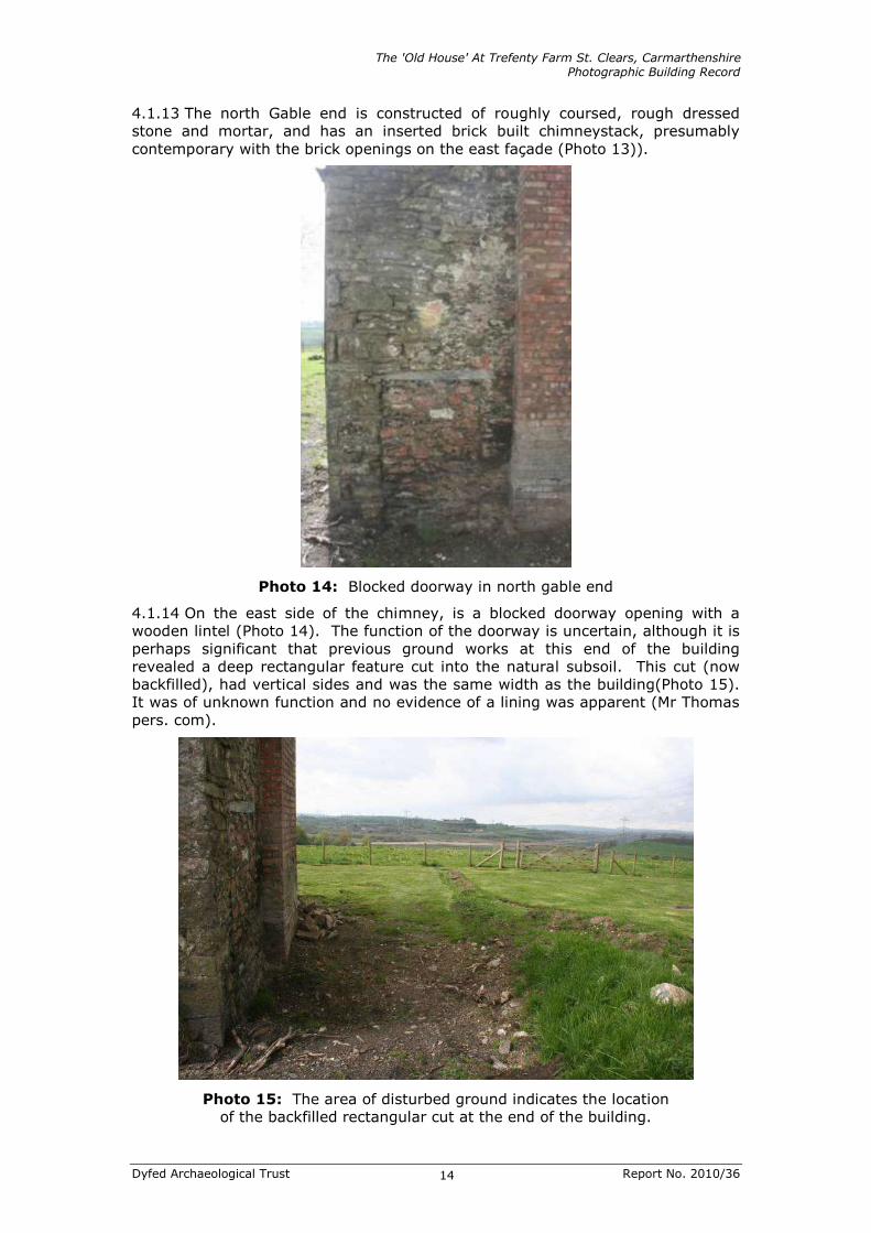
Photo 14: Blocked doorway in north gable end
4.1.14 On the east side of the chimney, is a blocked doorway opening with a
wooden lintel (Photo 14). The function of the doorway is uncertain, although it is
perhaps significant that previous ground works at this end of the building
revealed a deep rectangular feature cut into the natural subsoil. This cut (now
backfilled), had vertical sides and was the same width as the building(Photo 15).
It was of unknown function and no evidence of a lining was apparent (Mr Thomas
pers. com).
Photo 15: The area of disturbed ground indicates the location
of the backfilled rectangular cut at the end of the building.

The 'Old House' At Trefenty Farm St. Clears, Carmarthenshire Photographic Building Record
Dyfed Archaeological Trust Report No. 2010/36 15
4.2 Interior
4.2.1 The interior of the building was derelict and had not yet been cleared out
at the time of the recording visit. In addition, the majority of the walls were still
covered with plaster. In places, however, the plaster had fallen to reveal the
underlying masonry. There was no access to the first floor, although it was
partially visible through holes in the floor. The interior of the building appears to
have been entirely re-modelled at one time. Two exceptions to this are the
blocked doorway in the north gable end, and the blocked upper window in the
western elevation (Photo 16), both of which were blocked with stone on the
interior, rather than brick, suggesting these alterations happened at a different
(possibly earlier) time.
Photo 16: Former first floor window in west wall
blocked with stone (see also Photos 8 & 10).
4.2.2 No fixtures and fittings relating to either phase of the building were
apparent. There were no surviving stairs to the first floor and their former
location was not entirely obvious. They may have been located opposite the
entrance, built against the brick partition wall, in the southern room, although
this is by no means certain.
4.2.3 The ground floor is divided into two rooms, by a wall constructed of red
brick (Photo 17). Access from the front door, is directly into the southern room.
The main fireplace built from red brick was constructed against the south wall,
with an alcove on its east side (Photo 18).

The 'Old House' At Trefenty Farm St. Clears, Carmarthenshire Photographic Building Record
Dyfed Archaeological Trust Report No. 2010/36 16
Photo 17: Ground floor dividing
wall, constructed of brick
Photo 18: Fireplace against south
wall, constructed from brick.
4.2.4 An old range within the main fireplace may be contemporary with the brick
alterations to the building (Photo 19). A smaller fireplace constructed from red
brick was inserted into the north wall (Photo 20).
Photo 19: The old range within the main fireplace

The 'Old House' At Trefenty Farm St. Clears, Carmarthenshire Photographic Building Record
Dyfed Archaeological Trust Report No. 2010/36 17
Photo 20: North wall, showing inserted brick fireplace and chimneystack and
doorway to right, with wooden lintel and blocked with stone.
Photo 21: Ground floor and first floor windows at south end of east wall.

The 'Old House' At Trefenty Farm St. Clears, Carmarthenshire Photographic Building Record
Dyfed Archaeological Trust Report No. 2010/36 18
Photo 22: Ground floor windows in the east wall of the northern room
Photo 23: Brick-blocked window at the north end of
the western wall (see also Photo 9).
4.2.5 The rough faces of the stonework of the window reveals on the interior of
the east wall, may suggest there were originally smaller openings that have been
enlarged (Photos 21 & 22). The blocked window at the northern end of the
western façade was visible (Photo 23), and clearly demonstrated that it was brick
infilled on the interior with a stone fronting on the outer façade.
4.2.6 The roof timbers did not appear to be of great age, and no evidence of any
earlier roofing was visible.

The 'Old House' At Trefenty Farm St. Clears, Carmarthenshire Photographic Building Record
Dyfed Archaeological Trust Report No. 2010/36 19
5. DISCUSSION
5.1 The dressed and carved masonry blocks that have been used for the
quoins of the building have been re-used from an earlier building. This may have
been an earlier building on the same site as the current building, or another
nearby medieval building of which no trace is now apparent. The stone is,
however, most likely to have come from the medieval building that forms the
core of the main house at Trefenty, which has itself undergone numerous
alterations.
5.2 The evidence of blocked openings in the west and north walls would
appear to relate to the original construction of the building. On the tithe map its
location in relation to the other farm buildings, suggests it may have been a
farmhouse. As a result of the later alterations, however, it is difficult to ascertain
what the form of this building would have been. There is no surviving interior
evidence of room divisions or fireplaces. It is therefore possible that the building
had a non-domestic function.
5.3 The building was substantially re-modelled by the probable replacement of
earlier openings with larger doors and windows, and the blocking up of other
openings. At this point its function was definitely residential.
5.4 In addition, any original hearths that may have existed were replaced by
red brick fireplaces and chimneystacks. Most of this work is likely to have been
undertaken when the entire farm was re-modelled, some time between 1841 and
1888.
5.5 The two dormer windows are a later modification.
5.6 The building survey has provided evidence of the buildings history and
development. The proposed renovation works will retain the existing fabric of the
structure and thus any further evidence of its development will be preserved.
The building survey is considered to have provided an appropriate level of
recording of the structure.

The 'Old House' At Trefenty Farm St. Clears, Carmarthenshire Photographic Building Record
Dyfed Archaeological Trust Report No. 2010/36 20
6. SOURCES
The Regional Historic Environment Record, housed with Dyfed Archaeological
Trust in Llandeilo.
Dyfed Archaeological Trust web site.
Carmarthenshire County Council Planning Services web site.
Llanfihangel-Abercywyn parish tithe map and apportionment 1841.
Ordnance Survey 1st edition map 1888. 1:25,000
Ordnance Survey 2nd edition map 1906. 1:25,000

The 'Old House' At Trefenty Farm St. Clears, Carmarthenshire Photographic Building Record
Dyfed Archaeological Trust Report No. 2010/36 21
THE 'OLD HOUSE' AT TREFENTY FARM
ST. CLEARS, CARMARTHENSHIRE
PHOTOGRAPHIC BUILDING RECORD
RHIF YR ADRODDIAD / REPORT NUMBER 2010/36
Medi 2010
September 2010
Paratowyd yr adroddiad hwn gan / This report has been prepared by
Duncan Schlee
Swydd / Position: Field Services Project Manager
Llofnod / Signature ............…………................. Dyddiad / Date
Mae’r adroddiad hwn wedi ei gael yn gywir a derbyn sêl bendith
This report has been checked and approved by
James Meek
ar ran Ymddiriedolaeth Archaeolegol Dyfed Cyf.
on behalf of Dyfed Archaeological Trust Ltd.
Swydd / Position:
Llofnod / Signature .............…....…………....... Dyddiad / Date
Yn unol â’n nôd i roddi gwasanaeth o ansawdd uchel, croesawn unrhyw sylwadau
sydd gennych ar gynnwys neu strwythur yr adroddiad hwn
As part of our desire to provide a quality service we would welcome any
comments you may have on the content or presentation of this report


