15

THE OTTAWA RIVER BY NIGHT i
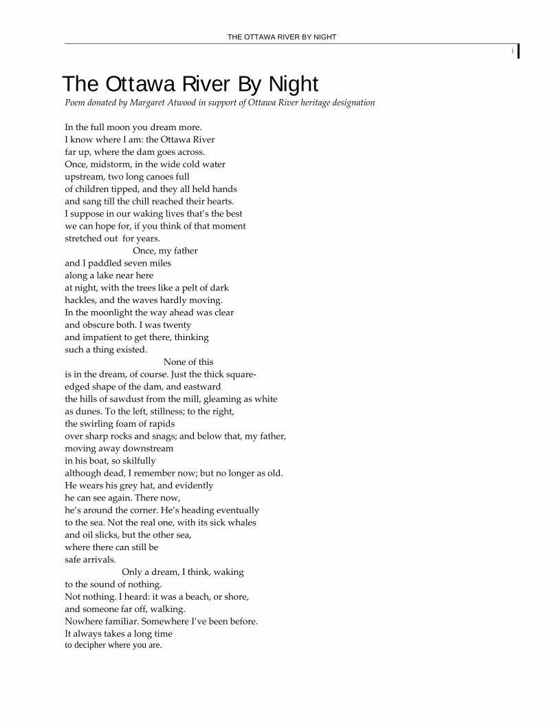
The Ottawa River By Night Poem donated by Margaret Atwood in support of Ottawa River heritage designation In the full moon you dream more. I know where I am: the Ottawa River far up, where the dam goes across. Once, midstorm, in the wide cold water upstream, two long canoes full of children tipped, and they all held hands and sang till the chill reached their hearts. I suppose in our waking lives that’s the best we can hope for, if you think of that moment stretched out for years. Once, my father and I paddled seven miles along a lake near here at night, with the trees like a pelt of dark hackles, and the waves hardly moving. In the moonlight the way ahead was clear and obscure both. I was twenty and impatient to get there, thinking such a thing existed. None of this is in the dream, of course. Just the thick square‐ edged shape of the dam, and eastward the hills of sawdust from the mill, gleaming as white as dunes. To the left, stillness; to the right, the swirling foam of rapids over sharp rocks and snags; and below that, my father, moving away downstream in his boat, so skilfully although dead, I remember now; but no longer as old. He wears his grey hat, and evidently he can see again. There now, he’s around the corner. He’s heading eventually to the sea. Not the real one, with its sick whales and oil slicks, but the other sea, where there can still be safe arrivals. Only a dream, I think, waking to the sound of nothing. Not nothing. I heard: it was a beach, or shore, and someone far off, walking. Nowhere familiar. Somewhere I’ve been before. It always takes a long time to decipher where you are.

ACKNOWLEDGEMENTS ii
Acknowledgements The Ottawa River Background Study is part of an ongoing community initiative to seek heritage designation for the Ottawa River. A team of individuals representing the general public, local organizations, municipalities and agencies in both Quebec and Ontario have contributed their time, enthusiasm and expertise to this initiative. We are thankful to all the volunteers who have assisted with writing, editing, organizing and fundraising. In particular, we would like to thank the following individuals who have assumed responsibilities essential to the coordination of this effort:
Len Hopkins, Ottawa River Heritage Designation Committee Honourable Benoît Pelletier, Ministry of Intergovernmental Affairs, Quebec
Organizational and Administrative Support
Natasha Amero, Information Officer Luce Bélanger Nicole Desroches, Conseil régional de l’environnement et du développement durable de l’Outaouais Jim Fraser, Ministry of Natural Resources, Ontario Brian Grimsey, Canadian Heritage Rivers System, Parks Canada Line Laquerre, Executive Assistant for Len Hopkins
Background Study Writing Team
Richard M. Bégin Adrienne Blattel, Quebec‐Labrador Foundation Lyal Campbell Douglas Champ Elder William Commanda, Circle of All Nations Gordon Cullingham, Historical Society of Ottawa Peter Di Gangi, Algonquin Nation Secretariat, Timiskaming Reserve Dr Allan Donaldson, Carleton University Dr Paule Doucet, Regroupement des organismes du patrimoine franco‐ontarien Shawn Graham and Gord Graham Simone Hanchet, Quebec‐Labrador Foundation Norman Hawirko Len Hopkins, Ottawa River Heritage Designation Committee Lynn Jones, Ottawa River Institute Hélène Landry, Conseillère Tourisme Plein Air Joann McCann, Friends of Oiseau Rock Cam McNeil Ray Metcalfe James Morrison, Sicani Research & Advisory Services Marian Patterson Dr. Jean‐Luc Pilon, Canadian Museum of Civilization Dr. John W. Pollock, Woodland Heritage Services Limited Chief Conrad Polson, Timiskaming First Nation Michel Prévost, Université d’Ottawa Bob Sherrif

ACKNOWLEDGEMENTS iii
Lyall Smith Chief Harry St. Denis, Wolf Lake First Nation Gary Thibert, Town Council of Mattawa Chief Kirby Whiteduck, Golden Lake Algonquins of Pikwakanagan
Funding Organizations and Partners
Archives of Ontario Canadian Heritage Canadian Heritage Rivers System, Parks Canada Canadian Power and Sail Squadron, Oiseau Rock Squadron Conseil régional de l’environnement et du développement durable de l’Outaouais Department of Indian and Northern Affairs Environnement Québec FedNor Friends of Bonnechere Parks Library and Archives Canada Ontario Ministry of Culture Ontario Ministry of Natural Resources Ontario Parks Ontario Trillium Foundation Ottawa River – Legacy Landmark Partners Ottawa River Waterway Ottawa Valley Tourism Association Quebec‐Labrador Foundation Renfrew County Community Futures Development Corporation South Temiskaming Shores Community Futures Development Corporation TD Friends of the Environment Foundation Town of Petawawa
TABLE OF CONTENTS iv
Table of Contents THE OTTAWA RIVER BY NIGHT (POEM BY MARGARET ATWOOD) ACKNOWLEDGEMENTS TABLE OF CONTENTS LIST OF TABLES LIST OF FIGURES LIST OF APPENDICES CHAPTER 1 INTRODUCTION
1.1 Description of the River 1.2 Project Structure 1.3 Project Scope 1.4 Community Support and Involvement
CHAPTER 2 CULTURAL HERITAGE
2.1 Ancient History of the Upper Ottawa River and Lake Temiskaming 2.1.1 Archaeology in the Ottawa River Valley 2.1.2 Descriptions of the Various Archaeological Cultures Along the Upper Ottawa River Summary
2.2 Ancient History of the Lower Ottawa River Valley 2.2.1 Archaeology in the Ottawa Valley 2.2.2 The Champlain Sea and Early Ottawa River 2.2.3 The Earliest Ottawa Valley People 2.2.4 The Pembroke Sites and Evidence of Early Trade Networks 2.2.5 Adapting to Ecological Niches 2.2.6 Ottawa Valley Ceramics 2.2.7 Wide Trade Networks Following the River Networks 2.2.8 Contact Period Algonquin Peoples Summary
2.3 Algonquin History in the Ottawa River Watershed 2.3.1 Algonquin Origins 2.3.2 The Algonquin Sense of Place 2.3.3 Algonquin, French and Iroquois 2.3.4 Algonquin People in the 18th Century 2.3.5 Algonquin People in the 19th Century 2.3.6 A Sacred Site: Oiseau Rock
2.4 Exploration Along the Ottawa River 2.4.1 European Context 2.4.2 The Explorers
TABLE OF CONTENTS v
2.4.3 The Interpreters 2.4.4 Missionaries on the Ottawa River 2.4.5 Sites Related to European Exploration Summary
2.5 The Fur Trade Along the Ottawa River 2.5.1 European Demand 2.5.2 Fist Nation Demand 2.5.3 The Early Fur Trade on the Ottawa River 2.5.4 Impacts of Trade with the Europeans 2.5.5 A Brutal War 2.5.6 The Voyageur Era on the Ottawa 2.5.7 British Competition with the French 2.5.8 The Fur Trade and Settlement 2.5.9 Decline of the Fur Trade 2.5.10 Lifestyle of the Voyageurs 2.5.11 The Rise of the Trapper 2.5.12 The Ottawa River Forts Summary
2.6 Settlement Along the Ottawa River 2.6.1 Earliest Settlement and the Fur Trade 2.6.2 From Furs to Farming 2.6.3 The British Encourage Settlement 2.6.4 Forestry – A New Attractive Prospect 2.6.5 Transportation and Communication 2.6.6 Ottawa – The Capital City 2.6.7 Settlement of the Upper Ottawa River Valley 2.6.8 The Culture and Diversity of the Settlers 2.6.9 Recent Settlement Along the Ottawa River 2.6.10 Sites Related to Settlement Summary
2.7 Logging in the Ottawa Valley – The Ottawa River and the Lumber Industry 2.7.1 Origins of the Timber Industry 2.7.2 Description of the Timber Industry 2.7.3 The Rise of the Sawn Lumber Industry (1850-1900) 2.7.4 Today’s Diversified Forestry Industry 2.7.5 Ecological Perspective 2.7.6 Sites Along the Ottawa River Related to the Forestry Industry Summary
2.8 Steamboa ts and Canals on the Ottawa River 2.8.1 Navigation Before Steamboats and Canals 2.8.2 The Construction of Military Canals on the Ottawa River 2.8.3 The Steamboats on the Ottawa River 2.8.4 Canal Improvements 2.8.5 Canal Construction on the Upper Ottawa 2.8.6 Navigation on the Ottawa River Today 2.8.7 Sites Related to Steamboats and Canals Summary

TABLE OF CONTENTS vi
2.9 Hydroelectricity on the Ottawa River
2.9.1 Paper and Power – Developing Hand in Hand 2.9.2 Electricity Takes to the Streets – Lighting and Tramways 2.9.3 Building Dams and Generating Electricity 2.9.4 Flood Control in the Ottawa River Basin 2.9.5 Quebec and Ontario – Sharing a Rich Resource 2.9.6 Impact of Hydroelectricity on the Environment of the Ottawa River 2.9.7 Generating Stations, Dams and Reservoirs on the Ottawa River 2.9.8 The New Face of Power: Nuclear 2.9.9 Sites Related to Hydroelectric and Early Power Development Summary
2.10 Aesthetic Values: Celebrating the Art of the Ottawa River Watershed 2.10.1 Selected Ottawa River Poetry
CHAPTER 3 NATURAL HERITAGE VALUES 3.1 The Geoheritage of the Ottawa River Drainage Basin
3.1.1 Our Geological Legacy 3.1.2 The Precambrian Shield 3.1.3 The Grenville Province 3.1.4 The Pleistocene Ice Age 3.1.5 Champlain Sea Sediments 3.1.6 The Ottawa River Today 3.1.7 Heritage Designation for the Ottawa River in Relation to
Geological Highlights Summary
3.2 Hydrological Features of the Ottawa River Drainage Basin 3.2.1 Size of the Ottawa River 3.2.2 Drainage Basin of the Ottawa River 3.2.3 Seasonal Variations 3.2.4 Water Content
3.3 River Morphology 3.3.1 Channel Pattern 3.3.2 Landforms and Depositional Forms 3.3.3 Waterfalls and Rapids 3.3.4 Lakes
3.4 Climate 3.4.1 Upper Stretches 3.4.2 Lower Stretches
3.5 Flora 3.5.1 In-stream Vegetation 3.5.2 Riparian Vegetation 3.5.3 Canopy Vegetation
3.6 Fauna 3.6.1 Fish 3.6.2 Mammals 3.6.3 Birds 3.6.4 Reptiles and Amphibians

TABLE OF CONTENTS vii
3.6.5 Invertebrates
3.7 Ecosystems 3.7.1 Riverine Systems 3.7.2 Lacustrine (Lake) Systems 3.7.3 Wetlands 3.7.4 The Riparian Zone 3.7.5 Forest Ecosystems
3.8 Con servation Along the Ottawa River 3.8.1 Parks Along or Near the Ottawa River 3.8.2 Nature Reserves Along or Near the Ottawa River 3.8.3 ZECs Along the Ottawa River 3.8.4 Other Conservation Areas Along or Near the Ottawa River 3.8.5 Organizations with a Conservation Mandate
CHAPTER 4 RECREATIONAL VALUES
4.1 Water Sports 4.1.1 Boating and Paddling 4.1.2 Swimming 4.2 Fishing and Hunting 4.2.1 Fishing 4.2.2 Hunting 4.3 Winter Activities 4.4 Trails and Corridors 4.4.1 Hiking and Walking 4.4.2 Cycling 4.5 Parks and Nature Reserves 4.5.1 Provincial Parks 4.5.2 Nature and Recreation Reserves 4.5.3 Other Examples of Parks and Recreation Areas 4.6 Camping 4.7 Nature Appreciation 4.8 Human Heritage Appreciation 4.8.1 Cultural Heritage Routes 4.8.2 Museums and Cultural Centres 4.8.3 Festivals and Events
CHAPTER 5 OTTAWA RIVER COMMUNITY HERITAGE
5.1 Lake Temiskaming Heritage, Ontario 5.2 A History of Mattawa 5.3 Highlights in the Settlement History of Renfrew County 5.4 Pembroke Area History 5.5 Settlement History and Archaeology Along the North Shore of the
Ottawa River, Pontiac County, Québec 5.6 The History of the Upper Canada Site of the Ottawa River Between
Shirley’s Bay to the East and the Madawaska River to the West

TABLE OF CONTENTS viii
5.7 La rivière des Outaouais: une rivière d’histoire et de patrimoine
pour les Comtés unis de Prescott et Russell 5.8 Life in the Logging Camps
CHAPTER 6 MANAGING THE HERITAGE VALUES OF THE OTTAWA RIVER
6.1 Existing Land and Water Use 6.1.1 Water Extraction 6.1.2 Urbanisation and Shoreline Development 6.1.3 Industry 6.1.4 Agriculture 6.1.5 Forestry 6.1.6 Mineral Resource Extraction 6.1.7 Peat Moss Extraction 6.2 Managing the Ottawa River as a Canadian Heritage River: Challenges and
Opportunities 6.2.1 Benefits and Opportunities Associated With Canadian Heritage River
Designation 6.2.2 Potential Challenges in Managing the Ottawa River as a
Canadian Heritage River 6.2.3 Toward a Shared Vision of the Ottawa River
CHAPTER 7 CONCLUSION
7.1 Human Heritage Integrity Assessment 7.2 Natural Heritage Integrity Assessment 7.3 Recreational Values Integrity Assessment 7.4 Recommendation
REFERENCES APPENDICES

LIST OF TABLES ix
List of Tables 1.1 Organizational Chart: The Ottawa River Heritage Designation Committee 2.1 Algonquin Calendar 2.2 Generating Stations on the Ottawa River 3.1 Geological Time Divisions 3.2 Geological Time Scale for our Planet 3.3 Introduction to the Three Types of Rock Present Along the Ottawa River 3.4 Ottawa River Discharge Volume as Measured at Carillon Dam 3.5 Low Flow Volume Classes of Canadian Rivers 3.6 River Size Classes with Examples 3.7 Water Properties Along the Lower Ottawa River 6.1 Mean Percentage of Land Use Class per Tributary Sub-basin of the Ottawa River 6.2 The Main Communities Along the Ottawa River

LIST OF FIGURES x
List of Figures Cover Image: Members of Dean's Big Show at the junction of the Mattawa and Ottawa Rivers, 1886. John Edward Gardiner Curran Collection/Library and Archives Canada/C-055206. 1.1 Ottawa River at its Source 1.2 Aerial View of the Outaouais 1.3 Mouth of the Rideau Canal From Parliament Hill 2.1 Harpoon Head 2.2 Copper Knife or Lance Head 2.3 Projectile Points 2.4 Ceramic Container 2.5 Ceremonial Knife 2.6 Oiseau Rock, ca. 1900 2.7 Pictographs at Oiseau Rock 2.8 The Explorers’ Routes 2.9 Champlain’s Map of Canada, 1653 2.10 Samuel de Champlain 2.11 Passing the Line: Hauling a Canoe Up a Rapid on the Ottawa River, ca. 1845 2.12 Champlain in a Canoe 2.13 Champlain With an Astrolabe on the West Bank of the Ottawa, 1613 2.14 Lake Allumette on the Ottawa River, ca. 1870 2.15 Radisson Meets First Nations Peoples at a Winter Camp 2.16 Encampment on the Ottawa River, ca. 1850 2.17 St. Theresa of the Little Flower, Fort William, Pontiac County, Quebec 2.18 Shooting the Rapids 2.19 Encampment of Voyageurs, Ontario, 1870 2.20 Burial Place of the Voyageurs, Ontario, 1841 2.21 Voyageurs and Raftsmen on the Ottawa, ca. 1818 2.22 At the Junction of the Mattawa and Ottawa Rivers 2.23 On the Portage – Lake Comandeau 2.24 Portage Along the Ottawa River, 1836-1842 2.25 Chats Rapids, ca. 1838-1841 2.26 Freight Canoe, Hudson Bay Company Post, Lake Temagami, 1896 2.27 “The Great Kettle”, Chaudiere Falls 2.28 Montebello – Home of Papineau 2.29 Papineau Castle, 1886 2.30 Papineau’s Residence, Ottawa River, 1854 2.31 Chaudiere Falls 2.32 Philemon Wright 2.33 Chaudiere Falls Seen From Hull, 1851 2.34 Ladysmith, Pontiac County, Quebec 2.35 Parliament Buildings, Ottawa, From the Opposite Side of the Ottawa River 2.36 Under Dufferin Bridge 2.37 Plan of the Lower Village of Hull, 1882 2.38 Ottawa City, Canada West (Upper Town), 1855

LIST OF FIGURES xi
2.39 Opening of the Parliament Buildings, June 8, 1866 2.40 Bird’s Eye View of the City of Ottawa, 1876 2.41 Lumbermen Enjoying Making Music With a Fiddle and Sticks in a Logging Camp, ca. 1943,
Gatineau, Quebec 2.42 Petawawa Point – Early Settlement 2.43 A View of the Mill and Tavern of Philemon Wright at the Chaudiere Falls 2.44 Loggers in Fitzroy Harbour 2.45 Survey of the North Shore of the Ottawa River Ordered by Wright and Papineau, 1817 2.46 A Square Timber Raft on the Ottawa River 2.47 The Drive 2.48 Timber Raft on the Ottawa River, ca. 1899 2.49 Perilous Situation of a Raft, Chaudiere Falls, 1855 2.50 Timber Slide With Raft at Bytown, ca. 1851 2.51 The First Lumber Raft Down the Ottawa River 2.52 The Duke and Duchess of Cornwall and York Running the Chutes at Ottawa, 1901 2.53 Regatta on the Ottawa River During the Visit of the Duke and Duchess of Cornwall and York,
1901 2.54 Loggers Poling the Raft 2.55 Inside a Shanty 2.56 Eddy’s Mills, 1912 2.57 John R. Booth 2.58 E.B. Eddy’s Manufacturing and Lumbering Establishment, ca. 1884 2.59 Side View of a Mill 2.60 Logging Mill in Arnprior 2.61 A Steam Tug 2.62 The Last Raft to Pass – Ottawa River, Hurdman’s, Ottawa, 1899 2.63 Canoe on the River, 1841 2.64 Steamer, “Duchess of York” 2.65 Launching of the Opeongo, Chats Lake 2.66 Steamer, “Anne Sisson” 2.67 Steamboat Captains From the Ottawa River Who Served With the Canadian Nile Contingent, 1884 2.68 Ottawa River Navigation Company – Steamer Peerless 2.69 Des Joachims Landing, 1882 2.70 Steamer “Argo” on Lake Temiskaming 2.71 Dam Construction at Rapides-des-Joachims 2.72 Divers Building the Dam at Rapides-des-Joachims 2.73 Lunchroom, Des Joachims 2.74 Housing, Des Joachims 2.75 Carillon Dam 2.76 Chats Falls, 1901 2.77 Building the Dam at Rapides-des-Joachims 2.78 Pointe au Baptême Showing the Nuclear Power Plant 2.79 River Spirit 2.80 Ottawa River 2.81 The Deep 3.1 Distribution of Bedrock Units Underlying the Drainage Basin of the Ottawa River

LIST OF FIGURES xii
3.2 Maximum Extent of the Champlain Sea, Approximately 12,000 Years Ago 3.3 Pillow Structures 3.4 Block of Banded Iron Formation 3.5 Typical Stratified Archean Sedimentary Rock 3.6 Paleosol 3.7 Tillite Overlying a Laminated Siltstone 3.8 Microscopic View of Nipissing Diabase 3.9 Spirit Rock 3.10 Vertical Section, Looking Northward, Across the Ottawa-Bonnechere Graben 3.11 Interlocking Crystalline Texture of Pegmatite 3.12 Dykes of Pegmatite and Aplite 3.13 Marble 3.14 Ordovician Brachiopods and Gastropods 3.15 Ordovician Stromatoporoids 3.16 Oblique View of Ordovician Limestone 3.17 Stromatolites 3.18 Silurian Limestone 3.19 Pelecypod Shells 3.20 Boulder Beach 3.21 Longitudinal Profile of the Lower Ottawa River 3.22 Average Monthly Flow - Ottawa River at Chats Falls 3.23 High Water on the Ottawa River, 1936 3.24 Peak Flow of the Ottawa River 3.25 Main River Channel of the Ottawa 3.26 Ottawa River Watershed 3.27 Orchid 3.28 Instream Vegetation 3.29 European Frog-bit 3.30 Woods Along the River 3.31 Longnose Gar 3.32 Channel Catfish 3.33 Beaver 3.34 Tree Swallow 3.35 Bald Eagle 3.36 Wood Turtle 3.37 Spotted Turtle 3.38 Milksnake 3.39 Along the Ottawa River 3.40 Wetland Along the River 3.41 Aerial View of the Alfred Bog 3.42 Large Flowered Trillium 3.43 Open Water Along the River 3.44 Voyageur Provincial Park 3.45 Stream, Fitzroy Provincial Park 3.46 Gillies Grove 3.47 Wetland – Outaouais Region 3.48 Common Mallard

LIST OF FIGURES xiii
4.1 Sea Kayaking 4.2 A Long History of Recreation 4.3 Rafting in Big Waters 4.4 Rafting on the Ottawa River 4.5 Running the Rapids 4.6 Paddling in Downtown Ottawa, Rivers Day 2005 4.7 Cruise on the Ottaw a River 4.8 Recreational Fishing 4.9 The Legacy of Fishing 4.10 Snowmobile Excursion 4.11 Cross Country Ski Race 4.12 Biking on the Route Verte 4.13 Pink Lake, Gatineau Park 4.14 Camping in the Old Days 4.15 Grande Chute, Fort Coulonge 4.16 Looking Up the Ottawa From the Parliament Grounds 4.17 Manoir Papineau National Historic Site 4.18 Pembroke Heritage Murals: The Timber Raft 4.19 Maplelawn Estate and Gardens 4.20 Canadian Tulip Festival 4.21 Gatineau’s Hot-Air Balloon Festival 5.1 View of a Town on the North Shore of the Ottawa River, ca. 1850 5.2 New Liskeard 5.3 Historic Mattawa 5.4 Pembroke Heritage Mural: The Pointer Boat 5.5 Above Grenville on the Ottawa River, ca. 1830 6.1 Aerial View of the Ottawa River, Outaouais Region 6.2 Urban Development Along the Ottawa River 6.3 Historic Logging 6.4 Sunset on the Ottawa River 6.5 Changeling

INTRODUCTION 1
List of Appendices A. Map 1: Ottawa River Watershed
Map 2: Location of the Ottawa River Watershed Map 3: Ottawa River Watershed – Section 1 – Montreal to Ottawa Map 4: Ottawa River Watershed – Section 2 – Ottawa to Mattawa Map 5: Ottawa River Watershed – Section 3 – Mattawa to Source Map 6: Ottawa River Watershed – Surficial Materials Map 7: Ottawa River Watershed – Forested Ecozones Map 8: Ottawa River Watershed – Wetlands and Forests Map 9: Ottawa River Watershed – Presence of Humans in Forested Areas Map 10: Ottawa River Watershed – Land Cover Map 11: Ottawa River Watershed – Productive Forest Land Use
B. Ottawa River Timeline C. Selected National Historic Plaques Along the Ottawa River D. Selected Ontario Provincial Historic Plaques Along the Ottawa River E. Selected Designated Historic Sites in Quebec F. First Nations Communities in the Ottawa River Watershed G. Principal Reservoirs in the Ottawa River Basin H. Species at Risk in the Ottawa River Watershed I. Fish Species in the Various Reaches of the Ottawa River J. Breeding Bird Species by River Reach


