41
GOVERNMENT OF MONTSERRAT The PDP Explained A Summary of the Draft Physical Development Plan 2012-2022 Prepared for the public consultation period - 24 th October to 22 nd December 2011

GOVERNMENT OF MONTSERRAT
The PDP Explained
A Summary of the Draft Physical Development Plan 2012-2022
Prepared for the public consultation period - 24th October to 22nd December 2011


The PDP Explained: A Summary of the Draft Physical Development Plan 2012 - 2022
Contents
INTRODUCTION 1
Introduction to the PDP 2012-2022 1
The public consultation period 2
UNDERSTANDING MONTSERRAT IN 2011 3
HOW CAN WE PLAN FOR THE FUTURE? 5
Introduction 5
Estimating land use requirements 6
Looking at land available for development 7
MAIN ELEMENTS OF THE LAND USE AND INFRASTRUCTURE PLAN 8
SUMMARY LOCAL AREA PLANS (LAPs) 17
Barzey’s 18
Cudjoe Head and Brades 20
Davy Hill, Little Bay and Carr’s Bay 22
Geralds and Drummonds 25
Lookout 27
Salem 29
St John’s 32
St Peters 34
Woodlands, Olveston, Old Towne and Isles Bay (Potential LAP) 36

The PDP Explained: A Summary of the Draft Physical Development Plan 2012 - 2022
Moving forward Montserrat 2012-2022

The PDP Explained: A Summary of the Draft Physical Development Plan 2012 - 2022
See the full version online: www.ppu.gov.ms Send comments to: [email protected] 1
Introduction
Introduction to the PDP 2012-2022
The Government of Montserrat (GOM) has prepared an updated national Physical Development Plan (PDP) for the north of Montserrat to cover the period 2012 to 2022. The PDP is a land-use plan that provides a framework to help deliver the goals of the Sustainable Development Plan, addressing issues such as pressure on land, limited resources and infrastructure development. In one way or another everyone on the island will be affected by the content of this plan – it sets out what development needs to happen and where it should go. It is also supported by a standalone ‘Infrastructure Plan 2012-2022’.
Although the volcano cannot yet be considered to have returned to dormancy, Montserratians have completed the recovery from the devastation of the past fifteen years. The PDP seeks a balance between promoting residential and commercial growth in Montserrat while making sure that environmental resources are protected and the risks of disaster, such as hurricanes, are minimised. It will look to manage different pressures on land, resources and infrastructure while ensuring that everyone in Montserrat has access to adequate housing, services, community facilities, recreational facilities and the like.
In summary, the PDP aims to ensure that: social infrastructure is adequately provided; the environment and cultural heritage are appropriately conserved; infrastructure needs for current residents and businesses, and for likely population increases and commercial development is well planned; conflicts between land use are minimised; Montserrat develops adequate and sufficient housing and that stock buildings are compliant to relevant development standards.
The 16 specific objectives on the PDP are set out in Section 1 on page 1 of the document
Everyone on Montserrat is affected by planning decisions for houses, agriculture, commercial space, and other developments. These decisions also affect the allocation of land for social infrastructure such as recreation, the location of infrastructure and all other issues related to land use.
Much of the land planning policy in the PDP is enforced through the planning and development process. Planning applications are granted or refused based partly on their compliance with the PDP.
Local Area Plans (LAPs) have also been updated. LAPs help to define how the main settlement areas should develop into the future, how to avoid conflicting land uses, what infrastructure should be implemented to enable and stimulate residential and economic growth and how to minimise risks from natural hazards. As the Woodlands to Isles Bay ‘beachettes’ area is all one land use type – residential with some flexibility for commercial activity beneficial to the community – and

The PDP Explained: A Summary of the Draft Physical Development Plan 2012 - 2022
See the full version online: www.ppu.gov.ms Send comments to: [email protected] 2
the Belham Vallay land use is to be defined according to GOM decisions following the EIA and Environmental Management Plan, an LAP was not included for the previous PDP and is not included in the consultation draft PDP 2012-2022. However, an LAP for this area will now be considered by the PDA due to demand from many local residents.
How is the PDP 2012-2022 implemented and enforced?
The PDP is a planning framework with legal status. The Physical Planning Unit (PPU) and the Planning and Development Authority (PDA) base their decisions on granting permission to development proposals on compliance with the PDP policy and land use zoning. The PDP also acts as a spring board for community and national projects such as recreational facilities, community centres and a market in Salem, making it easier for government to secure funding to make them a reality. The Development Standards are another important part of the PDP, setting out standards and requirements that proposed developments must conform to.
The public consultation period (24th October – 22nd December 2011)
During the public consultation period, from 24th October to 22nd December 2011, everyone in Montserrat and its diaspora abroad is able to review the draft PDP and make comments and representations to the Planning and Development Authority. The Physical Planning Unit (PPU) website contains all the sections of the draft PDP in downloadable format. You can also visit the launch exhibition for the consultation period online at www.ppu.gov.ms
Submitting a representation or comment is easy to do. You can send an email to [email protected], post a comment on the PDP website or even drop by the Physical Planning Unit, the public library in Brades or the LIME office in Sweeney’s, where representation can be made anonymously. All representations will be treated in confidence.
All representations and comments will be evaluated by the PDA in early January 2012. The PDA will decide on which amendments are to be incorporated into the updated PDP 2012-2022 which will be finalised by February 2012. During preparation of the draft PDP, consultations have been undertaken with GOM, special interest groups, social service providers, and NGOs. These consultations have reviewed the existing conditions outlined in the previous PDP, have helped identify the current problems and issues, and have informed land use and infrastructure planning solutions and planning policy in the new draft PDP.

The PDP Explained: A Summary of the Draft Physical Development Plan 2012 - 2022
See the full version online: www.ppu.gov.ms Send comments to: [email protected] 3
Understanding Montserrat in 2011
A key part of the PDP is outlining the baseline conditions in 2011. Doing this allows us to understand Montserrat today and what the needs, constraints and opportunities are for growth. This process allows us to identify what Montserrat currently lacks in terms of infrastructure, helps us to identify trends and patterns in growth or land use issues, and allows us to understand the constraints to development. You can find all this in Section 2 of the Draft PDP
Montserrat in 2011 - A poster from the public consultation launch exhibition
The PDP sets out the existing conditions for the following:
Environmental resources including topography, drainage, geology and soils, terrestrial and marine ecology, protected areas, vegetation, wildlife, heritage and archaeology.
Risk of disaster and natural hazards
Current settlement patterns and land use (See Figure 2.4 below)
Land ownership
Demographics and social conditions

The PDP Explained: A Summary of the Draft Physical Development Plan 2012 - 2022
See the full version online: www.ppu.gov.ms Send comments to: [email protected] 4
Existing land use in north Montserrat (Figure 2.4 in the Draft PDP)

The PDP Explained: A Summary of the Draft Physical Development Plan 2012 - 2022
See the full version online: www.ppu.gov.ms Send comments to: [email protected] 5
Public and social services including health care, education facilities, recreation, community centres, religious services and security and emergency services.
Physical Infrastructure such as the road power and water networks, wastewater facilities, sea and air access, government buildings, telecommunications and how certain infrastructure is vulnerable to natural hazards
How can we Plan for the Future?
Introduction
The PDP team spent much of the early part of 2011 speaking with government departments and many other stakeholders including local community groups and special interest groups, private businesses and NGOs. This helped to understand the government policy for development as well as to realise the needs and requirements for a wide range of communities and stakeholders. This was the initial stakeholder consultation part of the process and included community meetings for all the village areas.
Who is a stakeholder?
Stakeholders are people or groups who have particular interests or objectives. Every individual in Montserrat is a stakeholder for the PDP as they have a stake in the future development of the island. Montserrat’s diaspora are also stakeholders as well as several international groups with an environmental focus.
Much of the policy informing the PDP is from the Sustainable Development Plan (SDP) 2008-2020. This is added to by specific departmental policy such as the Food Production Strategy or the Draft Environmental Bill, both from MAHLE. Joining this with talking to stakeholders gave an idea of where Montserrat is heading and where it could get to if certain things are achieved and implemented.

The PDP Explained: A Summary of the Draft Physical Development Plan 2012 - 2022
See the full version online: www.ppu.gov.ms Send comments to: [email protected] 6
Population projections and development pathways were developed based on primary drivers and their resulting secondary and follow on economic impacts.
Montserrat’s Primary Economic Drivers
geothermal energy
improved sea and air access
fibre-optic links to Guadeloupe and St Kitts (for rapid ICT connections)
improving physical and social infrastructure
These primary drivers can potentially enable a huge increase in secondary economic activity and growth including tourism, business development, sports tourism, housing construction and so on. This is illustrated in Figure 3.1 on page 42 of the Draft PDP. If you want to read more about this process in more detail see Section 3 of the Draft PDP. Based on this process and in line with the SDP, a population projection of 10,000 by 2022 is the planning target which the PDP must accommodate. Projected population numbers are available in Table A3 in Appendix D of the Draft PDP.
Based on the planning parameters the next most important parts of planning for the future are understanding the needs and requirements for land and infrastructure in the coming decade and then understanding the type and locations of land available for development in north Montserrat. These processes are briefly described below.
Land use requirements
Taking into account future development initiatives and all of the concerns and requirements arising from the stakeholder consultation, an estimation can be made of the land use requirements.
It is estimated that a total of 600 to 900 acres will be required for development in the coming decade. This includes land for housing, government facilities, commercial and office uses, health, education and recreation, agriculture, tourism and industry. You can see a detailed breakdown of this in Table 4.1 on page 53 of the PDP.
The PDP Explained: A Summary of the Draft Physical Development Plan 2012 - 2022
See the full version online: www.ppu.gov.ms Send comments to: [email protected] 7
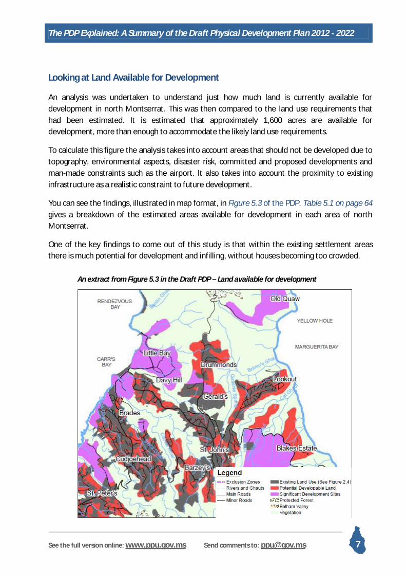
Looking at Land Available for Development
An analysis was undertaken to understand just how much land is currently available for development in north Montserrat. This was then compared to the land use requirements that had been estimated. It is estimated that approximately 1,600 acres are available for development, more than enough to accommodate the likely land use requirements.
To calculate this figure the analysis takes into account areas that should not be developed due to topography, environmental aspects, disaster risk, committed and proposed developments and man-made constraints such as the airport. It also takes into account the proximity to existing infrastructure as a realistic constraint to future development.
You can see the findings, illustrated in map format, in Figure 5.3 of the PDP. Table 5.1 on page 64 gives a breakdown of the estimated areas available for development in each area of north Montserrat.
One of the key findings to come out of this study is that within the existing settlement areas there is much potential for development and infilling, without houses becoming too crowded.
An extract from Figure 5.3 in the Draft PDP – Land available for development

The PDP Explained: A Summary of the Draft Physical Development Plan 2012 - 2022
See the full version online: www.ppu.gov.ms Send comments to: [email protected] 8
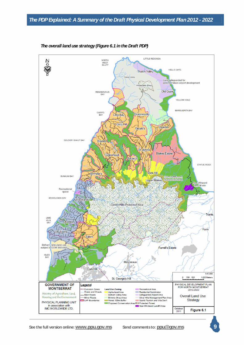
The Main Elements of the Land Use and Infrastructure Plan
The PDP aims to integrate a wide range of issues into a physical development strategy that supports the SDP development objectives. The plan aims to facilitate social development and economic growth activities, identified via public consultations across Montserrat, while ensuring that people have access to a wide range of services locally, have access to appropriate housing and community facilities and are able to maintain or attain a high quality of life. This must also support the valuable environmental and built heritage assets that underpin socio-economic development of the island through tourism, quality of life and water provision.
Land Use Policy Explained
The PDP 2012-2022 is a framework for development of Montserrat. It is a key planning document and as such has a great deal of influence on planning decisions made from small residential dwellings to large government funded projects. The PDP contains land use policy that will help the Planning and Development Authority (PDA) to make decisions on whether or not to grant planning permission to proposals. You can see the national Land Use Policy on Section 6 of the PDP or here on the PPU website: http://www.ppu.gov.ms/?page_id=35
The map below illustrates the wider land use strategy for north Montserrat. The areas shown in orange are the main settlement areas. With the exception of the beachettes area (Woodlands to Isles Bay, these are areas of more complex land use demands and community issues. For each of these areas a Local Area Plan (LAP) has been developed (see the following part) to describe the existing situation, the community issues, development opportunities and constraints, and the subsequent land use policy and infrastructure recommendations.
The PDP Explained: A Summary of the Draft Physical Development Plan 2012 - 2022
See the full version online: www.ppu.gov.ms Send comments to: [email protected] 9
The overall land use strategy (Figure 6.1 in the Draft PDP)

The PDP Explained: A Summary of the Draft Physical Development Plan 2012 - 2022
See the full version online: www.ppu.gov.ms Send comments to: [email protected] 10
The main elements of the Physical Development Plan 2012-2022 are laid out below.
A new capital town at Little Bay
Since 1999 Little Bay has been considered as a new capital town and economic centre for Montserrat. Government is now a advancing plans to develop Little Bay, Rendezvous Bay and Carr’s Bay as an integrated 3-Bay concept aimed at providing modern, efficient and attractive residential, commercial and tourism-related facilities that will spearhead the island’s economic recovery.
It is proposed to develop a port at Carr’s Bay that will accommodate small cruise-ships, cargo vessels, the ferry and some large yachts. The new quayside along Carr’s Bay would be developed as the new town’s waterfront, providing local business opportunities by way of shops, cafés and so on. This waterfront would extend through to the seaward end of Piper’s Pond where the “Evergreen Roundabout” (from old Plymouth) would be recreated. The new town would then extend from the roundabout eastwards to the new market and business court area within Little Bay. Within Little Bay itself, a high-end resort and government buildings would be constructed, along with a new recording studio to revive Montserrat’s music industry. Rendezvous would remain as a natural paradise unless there is a compelling case for a development such as a suitable high-end eco-style hotel or an adventure activity centre to further boost the tourism industry and overall economy of the island.
The existing jetty at Little Bay could be developed into a yacht marina, with a boatyard and boat repair facility in the Little Bay Ghaut area, creating a potentially significant new business opportunity. Local fishing vessels would be accommodated with safe moorings and maintenance areas. [See Section 7.5 in the Draft PDP]
A resilient network of decentralised village centres
While Little Bay and Brades will provide many of the islands services, retail and commercial facilities, the island’s other village centres will continue to meet the retail and commercial needs of local communities. This will ensure local access to services and, following lessons learnt from the loss of Plymouth, will avoid the risk of locating all services in one location.
Adequate and appropriate housing
Infilling and consolidation of existing settlement areas will meet most of the projected residential development needs during the plan period. Several significant new sites can be developed if there is demand for larger housing projects. These are outlined in Figure 5.3 of the PDP. The maximum densities of housing plots will be such that residents are able to own an area of garden. As development increases in the future and during the next PDP plan period it is anticipated that residents in Montserrat will need to accept higher density housing in some areas. Social housing will occur in areas of high and medium density housing and will be mixed
The PDP Explained: A Summary of the Draft Physical Development Plan 2012 - 2022
See the full version online: www.ppu.gov.ms Send comments to: [email protected] 11
with private properties to ensure that areas of low income households are avoided. [See Section 6.3.1 in the Draft PDP]
Economic activities
Tourism
Based on improved air and sea access, tourism will continue to grow toward a target figure of 15,000 arrivals per year. High-end tourism is intended for Little Bay, including a flagship hotel, restaurants, villas, volcano interpretation centre, museum, and a perhaps bio-diversity centre. A port at Carr’s Bay will provide for cruise/ships, large yachts, cargo vessels, and the ferry. Villa tourism will continue to be encouraged in the Beachettes area, while the development of guesthouses and restaurants will be encouraged throughout the north.
Sports tourism and villa tourism will be supported through strong investment in appropriate facilities. Land is allocated for a golf course to be developed on Blakes Estate along with a high-end villa development. This will complement the existing FIFA football pitch and can be enhanced with the provision of further sports facilities such as tennis and basketball.
Tourism based on the natural environment and the Soufrière Hills volcano will also be nurtured through permits for suitable eco-lodges at selected locations. These could serve the additional purpose of well managed buffer zones surrounding the protected Centre Hills area. [See Section 6.3.10 in the Draft PDP]
Agriculture
Global food security issues and high import costs currently leave Montserrat in a vulnerable position. Sufficient land is allocated on the northern and south-western fringes of the protected Centre Hills forest to meet and exceed the national food production targets. It is envisaged that agricultural production will benefit from new techniques and the use of greenhouses and net-houses, reducing the amount of land required and the incidence of insect pest damage to vulnerable crops. The MAHLE will encourage backyard gardening by ensuring appropriate housing densities. [See Section 6.3.7 in the Draft PDP]
Office space
Office space for commercial activities will be developed as the demand arises. It should be located in Little Bay, Brades, and in a new commercial zone north of the airport in Geralds. There should be adequate provision for local business in each village centre. Government offices will continue to be primarily located at the current headquarters in Brades, but some ministries and

The PDP Explained: A Summary of the Draft Physical Development Plan 2012 - 2022
See the full version online: www.ppu.gov.ms Send comments to: [email protected] 12
departments – particularly those offering services directly to the public – will be relocated to Little Bay. [See Section 6.3.12 in the Draft PDP]
Retail
As mentioned above, larger retail premises will be located in Little Bay, Brades, Geralds, while local facilities will be promoted in all village centres. [See Section 6.3.13 in the Draft PDP]
Industrial and storage facilities
Suitable light industrial and storage facilities will be permitted in Carr’s Bay, but would not be conducive to the planned tourism developments at Little Bay, except for a proposed boatyard in Little Bay Ghaut.
An industrial zone is also located at Brades around the existing power station, where land is currently allocated from the previous plan for industrial and storage purposes. Parts of Happy Hill are allocated for small scale ash/sand-based or agro-processing activities. A suitable water bottling plant site has been identified north of Salem. All developments of an industrial nature are subject to environmental screening to minimise adverse impacts. [See Section 6.3.11 in the Draft PDP]
Sand Mining
For the foreseeable future, sand-mining activities will be based in the Belham Valley area. This will be managed in such a way as to minimise the impact on the surrounding residential areas and on the environment. All sand-mining activities will, therefore, be subject to the findings and provision of relevant technical studies, an Environmental Impact Assessment and an associated Environmental Management Plan and, to be enforced through appropriate legislation. [See Section 6.3.11 in the Draft PDP]
Community Services
Educational Facilities
Existing primary school arrangements are considered to be adequate for projected demand during the plan period, but additional pre-school (kindergarten) facilities could be provided by the private sector. Options for the possible relocation of the Montserrat Secondary School have been identified. Private sector investment in tertiary education will be promoted, including a permanent medical school and possibly a school of public management; both of these facilities would be “twinned” with appropriate well-reputed academic institutions, probably in the USA, UK or Canada. [See Section 6.3.2 in the Draft PDP]
The PDP Explained: A Summary of the Draft Physical Development Plan 2012 - 2022
See the full version online: www.ppu.gov.ms Send comments to: [email protected] 13
Health Facilities
The Glendon Hospital will be redeveloped during the plan period to meet the needs of the expected increase in population and changing demographic profile. Local clinics will be similarly upgraded in response to changes in local population and demographics. Improved health care facilities will be provided with additional local clinics in Lookout and Little Bay. [See Section 6.3.3 in the Draft PDP]
Recreational Facilities
The need for public recreation space in Montserrat will be addressed through the provision of safe and appropriate green space and recreational facilities in every village centre. Community centres should be available for public events, local activities and training in each village centre. Land has been identified at Woodlands, St John’s and Lookout for additional open recreation space and Brimm’s Ghaut is to develop a network of exercise trails. [See Section 6.3.5 in the Draft PDP]
Public Cemetery
The location of a national public cemetery has been approved in eastern Lookout. This will be buffered by an attractively landscaped community park. Further public cemeteries will be required during the PDP plan period and suitable locations will be found subject to ground condition studies. [See Section 6.3.6 in the Draft PDP]
Infrastructure
Geothermal Energy
Geothermal energy will be developed to provide a reliable, economic and sustainable means of producing the island’s electricity. Subject to successful exploration results, the geothermal power plant will be large enough to provide sufficient energy for export to Antigua. [See Section 6.3.18 in the Draft PDP]
Telecommunications
Montserrat will be reconnected to the two Caribbean regional fibre-optic telecommunication networks. This will provide fast, reliable Internet and telephony links to the whole world and encourage the establishment of Information and Communication Technology (ICT) businesses on the island. Additionally, it will facilitate video-conferencing for international business purposes and video-lecturing in support of higher education. Where appropriate, services will be placed underground. [See Section 6.3.21 in the Draft PDP]
The PDP Explained: A Summary of the Draft Physical Development Plan 2012 - 2022
See the full version online: www.ppu.gov.ms Send comments to: [email protected] 14
Access
The new port at Little Bay will accommodate the ferry, fishing vessels, yachts, and small to medium-sized cruise ships (max. 1,000 passengers). The port area and moorings for relatively small boats will be protected by a suitable breakwater. A marina at Little Bay or Carr’s Bay will serve the needs of larger yachts.
The airport runway at Geralds is sufficient to meet projected passenger movements in the plan period, but the terminal building will be upgraded to increase passenger throughput, provide for CIPs, and improved restaurant facilities. The control tower will be relocated, possibly integrating it with the terminal building, and space will be designated as a commercial helipad. Issues of safety will be held under constant review and this will include reserving land for a possible new runway. [See Sections 6.3.15/16 in the Draft PDP]
Road Transportation
The road network will be gradually improved, including new link roads where appropriate to improve traffic circulation to ease congestion and avoid bottlenecks in the event of evacuating areas near the Exclusion Zone. These can be seen in Figure 6.5 on page 103 of the Draft PDP These investments will be protected via an increasingly proactive approach to preventative road maintenance.
Safety will be improved for vehicular road users by improving road alignment, road markings and roadside features. Pedestrian safety will be enhanced via suitable sidewalks between residential/commercial areas. [See Section 6.3.14 in the Draft PDP]
Energy
The reliability of the power network will be improved by replacing obsolete equipment, including old diesel generators and transmission and distribution items. Appropriate distribution items will be placed underground. Geothermal energy should become available during the plan period, reducing the role of the diesel power station to one of a backup facility. Geothermal will reduce the reliance on other forms of renewable energies, but solar panels (especially for hot water provision in houses and offices) will be actively encouraged. [See Section 6.3.18 in the Draft PDP]
Water Supply
The springs and wells that provide the island’s fresh water will be protected, including a programme to improve the existing infrastructures at these sites. Potable water storage capacity will be increased, initially to address current needs and then to provide for projected demand associated with major developments at Little Bay, Carr’s Bay and elsewhere across north Montserrat. Old distribution lines will be gradually replaced to maintain the quality of supplies and to meet projected demand. [See Section 6.3.17 in the Draft PDP]

The PDP Explained: A Summary of the Draft Physical Development Plan 2012 - 2022
See the full version online: www.ppu.gov.ms Send comments to: [email protected] 15
Water Treatment
Existing sewage treatment facilities will be upgraded, and communal systems will be introduced to meet the needs of growth in existing residential areas and for new residential developments. Some facilities, such as Davy Hill and Lookout, will be relocated to avoid dangers from effluent overflows. [See Section 6.3.19 in the Draft PDP]
Solid Waste
The existing landfill site at New Windward will be redesigned and reorganised to improve the effective environmental management of solid waste. This, as far as practicable, will include lining the existing site and setting aside separate areas for specific waste streams. [See Section 6.3.20 in the Draft PDP]
Emergency Services
The police, fire and ambulance stations will be retained at Brades and Salem. Access/egress at Brades will be improved via a new road link. A new ambulance station will be provided at Little Bay to serve tourists and new residents in this area as well as the adjacent areas of Davy Hill, Carr’s Bay, Drummonds, and Geralds. [See Section 6.3.9 in the Draft PDP]
Tourism Infrastructure
Hiking trails, clearly marked from the main roads, will encourage tourists to investigate Montserrat’s natural beauty. An improved maintenance programme will make it easier for people to undertake walks into the Centre Hills and Silver Hills areas. Heritage programmes will identify public buildings of cultural importance to be protected and, in suitable cases, to be opened to the public as places of interest. [See Section 6.3.10 in the Draft PDP]
Minimising vulnerability to disaster
Land development is proposed in a manner that vulnerability is reduced to the range of disasters that Montserrat is likely to experience, including the anticipated effects of climate change. This is reflected, for example, in the location of critical infrastructure. Where land use planning is unable to minimise the risk to residential areas to phenomena such as hurricane wind speeds, it is crucial to mitigate these risks through enforcing appropriate Development Standards, as set out in Appendix A of the Draft PDP, and appropriate building codes
Where areas are at perceived risk from volcanic activity, such as Salem and its immediate vicinity, it is important to support social and economic development, making these areas vibrant and attractive places to live and to do business.

The PDP Explained: A Summary of the Draft Physical Development Plan 2012 - 2022
See the full version online: www.ppu.gov.ms Send comments to: [email protected] 16
Environment and Conservation
Montserrat will ensure that its reputation as the “Emerald Isle of the Caribbean” will continue with strict protection maintained of the Centre Hills. A network of riparian strips and green buffer zones along the island ghauts will be closely managed to avoid inappropriate development that may threaten ecology, water courses, or attractive views. These are indicated in green in Figure 6.1, above. This green core will continue to support quality of life and economic development through recreation, and low volume, eco-appropriate tourism. Strict management measures will be employed to balance development with environmental sustainability across the island. [See Section 6.3.23 in the Draft PDP]
Protecting Montserrat’s natural environment and biodiversity
Cultural Heritage
The historic focus of heritage and archaeological protection has been Plymouth and the south of Montserrat. Planning permissions for development in the north will take full account of important sites of historic and socio-cultural significance. Wherever possible, sites and artefacts will be preserved for future generations and to ensure that Montserrat’s multi-cultural population understands the island’s rich heritage and sense of self. An urgent examination of these sites will lead to a series of detailed protection and management measures. Where it is not possible to fully preserve a site, adequate opportunity must first be given to qualified archaeologists to examine, excavate and document the site, and for artefacts to be catalogued and moved to the museum. [See Section 6.3.23 in the Draft PDP]

The PDP Explained: A Summary of the Draft Physical Development Plan 2012 - 2022
See the full version online: www.ppu.gov.ms Send comments to: [email protected] 17
Local Area Plans (LAPs)
The final section of the PDP (Section 7) looks in detail at the main settlement areas around the island. Local Area Plans are set out for these areas as illustrated in Figure 7.1 of the PDP.
The LAP locations in the Draft PDP

The PDP Explained: A Summary of the Draft Physical Development Plan 2012 - 2022
See the full version online: www.ppu.gov.ms Send comments to: [email protected] 18
The main principles that should guide the development in Local Area Plans are set out here:
A suitable mix of land uses including residential and commercial, retail and recreational is crucial to creating vibrant communities where people want to live, work and spend time
Supporting community needs and providing venues and facilities for recreation, learning, skills enhancement and general meetings and activities
Local access to sports and recreation, which is crucial for the healthy development of Montserrat’s population.
Improving the movement and access network within and between communities will help to increase economic opportunities and access to services, community and recreational facilities. This means not just a more efficient road network, but safer pedestrian facilities such as walkways and pedestrian crossings.
Ensuring access to agriculture and back yard gardening
Strong environmental management with the identification and preservation of environmental assets
Celebrating cultural heritage, whether it’s archaeological remains or buildings where notable people such as Arrow have lived.
Barzey’s LAP
Barzey’s will grow as a residential area and based on population projections and land availability, the area could expand from a 2006 population of 90 to a population of 200 by 2022. Approximately 64 acres are available for development, not taking into account land ownership issues.
Residential areas are to be encouraged at low to medium density with many of the currently subdivided plots measuring around a quarter to a sixth of an acre. Recreational facilities should ideally be included in development if suitable land can be allocated. Key residential sites are the sub-divisions identified in the land use zoning map. Due to the close proximity of St John’s and Cudjoe Head there is no need for a commercial centre. However, local shops and commercial activity are encouraged throughout the settlement, apart from in subdivisions where covenants limit commercial activity.
A significant constraint to development in the area is the state of the access road from Cudjoe Head to St John’s. The under-designed main road between these villages will be widened and made safer.

The PDP Explained: A Summary of the Draft Physical Development Plan 2012 - 2022
See the full version online: www.ppu.gov.ms Send comments to: [email protected] 19

The PDP Explained: A Summary of the Draft Physical Development Plan 2012 - 2022
See the full version online: www.ppu.gov.ms Send comments to: [email protected] 20
Several additional constraints to development have been identified which will be addressed for long term development to take place. The steep topography across much of the Barzey’s area will require carefully engineered structures. The risk of land instability and flood risk is made worse when plots are cleared of vegetation. The PDP policy states that 50% of vegetation on a plot must be retained when being developed. The ecologically significant areas along the ghauts must be protected and the presence of internationally important range restricted and endemic plant species mean that development must be carefully monitored by the Department of Environment.
You can see the detailed land use policies that relate to Barzeys in the Local Area Plan section of the PPU website at www.ppu.gov.ms or at the public library or the LIME office.
Cudjoe Head and Brades LAP
For the purposes of the Physical Development Plan, the Cudjoe Head and Brades Local Area Plan also includes Manjack, Baker Hill, Nixons and Banks. The area is considered the central settlement of Montserrat and is an extensive area of 348 acres covering the ridge between Collins Ghaut to the north east and Soilder Ghaut to the south west. Since the volcanic activity in the 1990s, Brades has become the centre of government and commerce on the island.
Based on population projections and land availability, the communities comprising this area are expected to expand from a 2006 population total of 942 to a population of 1,590 by 2022. Brades is likely to share the role of Montserrat’s economic centre with the new developments at Little Bay and Carr’s Bay. As such it should continue to support a range of businesses, public services, government offices and social infrastructure, as well as residential growth. The establishment of recreation and open space should be prioritised. Approximately 116 acres are available for development within the area, not taking into account land ownership issues.
The plan encourages the development of a more concentrated commercial strip along the main road, while maintaining flexibility for residential use here as well. However, the linear commercial strip can be unsafe for pedestrians and inconvenient for urban use. The speed of the through road traffic is dangerous for pedestrians and efforts will be made to enhance safety and ease of access to side roads and driveways. Street lighting is also recommended along the main roads.
The majority of the LAP area is zoned as predominantly residential with flexibility for commercial activity in residential areas. There is significant potential for infilling and consolidation of the existing settlement area. One area where the PDP team needs feedback is land use in Brades, Baker Hill and Banks. Should significant agricultural land be protected in this area to help

The PDP Explained: A Summary of the Draft Physical Development Plan 2012 - 2022
See the full version online: www.ppu.gov.ms Send comments to: [email protected] 21

The PDP Explained: A Summary of the Draft Physical Development Plan 2012 - 2022
See the full version online: www.ppu.gov.ms Send comments to: [email protected] 22
Montserrat grow more local fruit and vegetables or should owners be free to develop residential or commercial land as necessary?
There is an emphasis on creating mixed use communities where people have access to a wide range of housing and services in a close area. An area of predominantly commercial land is allocated below government headquarters, overlooking the sea.
An industrial area is allocated between Shinnlands and the sea where the existing power station and workshops are. An abattoir is proposed to be located in the industrial area to the west of the power station. Is this acceptable to the residents around this area?
A network of side roads provide access to the surrounding neighbourhoods and provide some important alternative routes. The road to Banks via Nixon’s allows traffic to bypass Cudjoe Head during local festivities and road works in Brades. The Plan recommends that these alternative routes to the main road are widened and well maintained.
Many people depend on bus and taxi transport to get to and from Cudjoe Head and Brades. People congregate in a number of unofficial stopping areas, which creates congestion and road traffic hazard. There are limited locations to shelter from rain while waiting for buses. The plan aims to provide more formal and sheltered waiting areas.
The LAP area includes several historical sites and features. Which are to be preserved or enhanced in any development proposals. The northern slopes of the Cudjoe Head and Brades area include areas of particular sensitivity for endemic flora; plants that are found only in Montserrat. Development proposals in these areas will not be approved until a site survey has been undertaken by the Department of Environment.
The PDP introduces the idea of Character areas. The centre of Cudjoe Head is one of the island’s four character areas with the aim of keeping what makes the village attractive and interesting for local inhabitants and for tourists. The Physical Planning Unit will bear this in mind when evaluating planning applications.
You can see the detailed land use policies that relate to Cudjoe Head and Brades in the Local Area Plan section of the PPU website at www.ppu.gov.ms or at the public library or the LIME office.
Davy Hill, Little Bay and Carr’s Bay LAP
Davy Hill, Little Bay and Carr’s Bay is an area that is likely to see exciting changes in the very near future. Over the years a variety of plans have been discussed for Little Bay and most recently for Little Bay and Carr’s Bay as a combined waterfront.

The PDP Explained: A Summary of the Draft Physical Development Plan 2012 - 2022
See the full version online: www.ppu.gov.ms Send comments to: [email protected] 23
Approximately 31 acres in Davy Hill, 36 acres in Carr’s Bay and 130 acres in Little Bay are available for development, not taking into account land ownership issues.
The successful development of this area is to be based on the Three Bay Concept, initially recommended for the area in the late 1990’s. The concept maximises the potential of this stretch of coastline through a holistic approach to planning for Carr’s Bay, Little Bay and Rendezvous Bay.
In October 2011 a design review was held to rethink the master plan for the Little Bay and Carr’s Bay area. The 2009 master plan was flawed in some areas and did not include enough potential revenue streams to make it financially viable.
The preferred concept option from the review is Option B which sees a radical changes to the 2009 master plan such that the port is located at Carr’s Bay.
This will accommodate small cruise-ships, cargo vessels, the ferry and some large yachts. The new quayside along Carr’s Bay would be developed as the new town’s waterfront, providing local business opportunities by way of shops, cafés and so on. This waterfront would extend through to the seaward end of Piper’s Pond where the “Evergreen Roundabout” would be recreated as a reference to the old meeting point in Plymouth.
The new town would then extend from the roundabout eastwards to the new market and business court area near the Montserrat Cultural Centre. Within Little Bay itself, a high-end resort would be constructed, including a hotel at the former Festival Village area and residences, a spa and recording studio on Potato Hill.
The cricket ground would be enhanced by way of amphitheatre seating that would serve cricket spectators and double as seating for recreational events (concerts, sports days, etc) on the cricket field. A memorial park may be located adjacent to the cricket pitch, suitable for national events and commemorating loved ones who have passed away.
The existing jetty at Little Bay could be developed into a yacht marina, with a boatyard and boat repair facility in the Little Bay Ghaut area, creating a potentially significant new business opportunity. The existing quarry would be shut down and an alternative site found, subject to technical studies.
A short but effective new road is proposed that would link the rear of the Little Bay site to Drummonds. This would provide another access route from the northern villages down towards Carr’s Bay and a second main access route into and out of Little Bay.
It is very important to integrate Davy Hill into the successful development of Little Bay and Carr’s Bay. Economic benefits and job opportunities must benefit the community at Davy Hill for the long term development and sustainability of the area.

The PDP Explained: A Summary of the Draft Physical Development Plan 2012 - 2022
See the full version online: www.ppu.gov.ms Send comments to: [email protected] 24

The PDP Explained: A Summary of the Draft Physical Development Plan 2012 - 2022
See the full version online: www.ppu.gov.ms Send comments to: [email protected] 25
This can be achieved not through spatial planning but with the consideration of how skills and information can be transferred to the local population to enable them to have access to the new jobs market. The Davy Hill area will see the development of a community centre and land is to be allocated for recreational use. A more concentrated strip of commercial activity is encouraged along the road up towards Sweeney’s.
Rendezvous Bay will continue to offer a natural paradise as a beach and inland area that is accessible by boat or on foot.
The PDP team would like to hear your comments on these proposed ideas. You can see the detailed land use policies that relate to Davy Hill, Little Bay and Carr’s Bay in the Local Area Plan section of the PPU website at www.ppu.gov.ms or at the public library or the LIME office.
Specific policies include allocating land for a clinic and small fire and ambulance station in Little Bay, ensuring that safe harbour and maintenance facilities are provided for fishermen and providing appropriate public facilities and showers at Little Bay and Carr’s Bay beaches.
Geralds and Drummonds LAP
Since the development of the John A. Osborne airport the settlement of Geralds has been significantly reduced in size and for planning purposes Geralds and Drummonds are considered as one local area.
The area is the northernmost settlement in Montserrat and is bordered by the Silver Hills in the north.
Geralds and Drummonds will continue to expand as residential areas. Based on population projections and land availability, the area can expand from a 2006 population of 212 to a population of 400 by 2022. Predominantly residential growth should be encouraged in the full extent of the settlement area. This area will also have the flexibility to include commercial activity such as shops and small businesses, encouraging a mixed use community.
The airport flight path and surrounding zones limits the development of the areas to the immediate east and west of the airport. Development here needs to be in compliance with the relevant standards identified in the PDP.
There is potential for a mixed use office and commercial unit complex just north of the airport which will support local economic activity. Community and recreational facilities should be incorporated into this new development if possible.

The PDP Explained: A Summary of the Draft Physical Development Plan 2012 - 2022
See the full version online: www.ppu.gov.ms Send comments to: [email protected] 26

The PDP Explained: A Summary of the Draft Physical Development Plan 2012 - 2022
See the full version online: www.ppu.gov.ms Send comments to: [email protected] 27
Land is allocated for recreational space (although not large enough for a cricket pitch) and for a community centre to the north of the airport as shown on the map. This should include play facilities for small children.
Visual impact of development along the west of Geralds must be considered with respect to the Little Bay landscape from below. As such, development is restricted along the ridgeline overlooking Little Bay.
A road link is proposed between Drummonds and Little Bay to provide access to this area and to include Geralds and Drummonds in the benefits of developments at Little Bay and Carr’s Bay.
As part of the wider land use plan for north Montserrat, exercise trails are proposed along Brimm’s Ghaut and access to these should be provided from Geralds and Drummonds. Would you use trails in this area? Should they be lit for use after dark?
You can see the detailed land use policies that relate to Geralds and Drummonds in the Local Area Plan section of the PPU website at www.ppu.gov.ms or at the public library or the LIME office.
Lookout LAP
Lookout has expanded rapidly since 2000 through the construction of various housing projects on government owned land. It is now the largest single neighbourhood in Montserrat with a 2006 population of 583.
Lookout will continue to expand as a residential settlement but it has the least space for development of all the LAPs. Empty lots will be infilled and where possible residential dwellings will be added to the fringes of the area.
Based on population projections and land availability, Lookout can expand to a population of 700 by 2022, from a 2006 population of 583. It will mature and develop as an urban space. Vegetation will increase offering protection from wind, sun and surface run off.
The commercial sector will increase in Lookout offering local access to basic items and local services and as such shops and limited commercial activity is encouraged throughout the settlement.
Community space for leisure, recreation and sports will increase and the green space through the centre of Lookout will be protected with no development permitted in these areas. A clinic, which is currently lacking from Lookout, is proposed for the area.

The PDP Explained: A Summary of the Draft Physical Development Plan 2012 - 2022
See the full version online: www.ppu.gov.ms Send comments to: [email protected] 28

The PDP Explained: A Summary of the Draft Physical Development Plan 2012 - 2022
See the full version online: www.ppu.gov.ms Send comments to: [email protected] 29
In 2010 land was allocated for Montserrat’s next public cemetery on a 3 acre plot on the east coast of Lookout overlooking the sea. This is to be surrounded by a well landscaped and planted community park area. The open space overlooking Gerlads airport cannot be developed due to airport constraints but can be used for agricultural or recreational activities. What would you like this space to be used for?
High end housing are to be developed along the east coast, south of the cemetery with stunning views along the coast and over to Antigua.
As part of the wider land use plan for north Montserrat, exercise trails are proposed along Brimm’s Ghaut and access to these should be provided from Lookout. Subject to wastewater infrastructure requirements, use of land at Margharita Bay is encouraged for recreational purposes.
You can see the detailed land use policies that relate to Lookout in the Local Area Plan section of the PPU website at www.ppu.gov.ms or at the public library or the LIME office.
Salem LAP
Salem, including the local areas of Happy Hill, Hope, Fleming and Frith, is a sizeable settlement lying in the extreme south of the northern zone. Parts of it are in Zones A and B of the exclusion zone system. The area was evacuated during the volcanic activity of the late 90’s but has been re-inhabited since 1998. Salem has changed significantly since the volcanic activity of the mid ‘90s. It used to be one of the key commercial centres on the island but has since lost much of this activity.
Salem has changed since the volcanic activity from one of the main village centres to an area starved of investment and poorly maintained. However, the village still has a vibrant centre and 12 per cent of the island’s population lives below the Nantes River. The LAP area covers 271 acres. There is a small concentration of shops in the centre of the village. Salem Park is the island’s second cricket pitch, along with the one at Little Bay, and provides facilities for a range of sports and events for the local and the national community.
Salem must not be allowed to deteriorate due to a lack of public and private investment. The area constitutes a valuable inhabitable area of north Montserrat. Action to stop the decline of Salem will avoid difficult social and financial problems in the future. There is no greater risk to the majority of Salem (areas not in zone B) than there is to the rest of the island in terms of violent volcanic activity such as pyroclastic flows. The area is susceptible to ashing but, depending on wind direction, this is a vulnerability of the entire island.

The PDP Explained: A Summary of the Draft Physical Development Plan 2012 - 2022
See the full version online: www.ppu.gov.ms Send comments to: [email protected] 30

The PDP Explained: A Summary of the Draft Physical Development Plan 2012 - 2022
See the full version online: www.ppu.gov.ms Send comments to: [email protected] 31
Based on population projections and land availability, the area is likely to expand from a 2006 population of 688 to a population of 1,020 by 2022. Salem will continue to grow as a vibrant commercial centre with an important sports venue at Salem Park and a national public events space in the village centre.
A significant constraint to development is the reduced access to finance and insurance. The PDP looks to promote solutions to development despite this. One such proposal is the construction of a simple covered market in the centre of Salem for local farmers and vendors to sell locally grown fruit and vegetables and perhaps at certain times, fish. A popular market established in the village centre is likely to attract a wider range of people to the village centre which will provide a base for attracting new businesses.
Residential development will grow in all areas with flexibility for low impact commercial activity throughout. A more concentrated area of shops and businesses is encouraged in the centre of Salem along the main road.
A higher concentration of agricultural activity is encouraged in the south east of the LAP area in Fleming and Friths. Light scale industries are encouraged in appropriate locations. An industry such as water bottling would be suitable on the land below Duckpond, subject to strict environmental management. Light industry is also promoted by the LAP on the southern edges of Salem where impact on surrounding areas is minimised.
The area and its facilities and amenities should be made particularly attractive to middle income families, as well as catering for all other age and income brackets, as they will help drive forward a successful local village and economy. As such attractive facilities for children to play in are to be allocated land. Public space for events in the centre of Salem, especially St Patrick’s Day, are to be preserved.
A potential road link from the main road near Rams through Hope to the MVO is proposed. This will also open up land for development to the north east of Salem in the Hope area. [Shot of this area]. Will this be useful for developing the area.
The PDP introduces the idea of Character areas. The centre of Salem is one of the island’s four character areas with the aim of keeping what makes the village attractive and interesting for local inhabitants and for tourists. The Physical Planning Unit will bear this in mind when evaluating planning applications.
You can see the detailed land use policies that relate to Salem in the Local Area Plan section of the PPU website at www.ppu.gov.ms or at the public library or the LIME office.

The PDP Explained: A Summary of the Draft Physical Development Plan 2012 - 2022
See the full version online: www.ppu.gov.ms Send comments to: [email protected] 32
St John’s LAP
The St John’s area extends from Sweeney’s and the airport in the north to Dick Hill and Judy Piece in the south east and Mongo Hill in the south west. This is an area that stretches almost to the fringes of the Centre Hills. As with much development in north Montserrat the settlement has built up along the ridge lines. More recent development has occurred on steeper slopes beyond the ridge lines.
The St John’s LAP area covers 272 acres of which approximately 70 acres are available for development, not taking into account land ownership issues.
St John’s is an important village centre and includes a significant amount of the island’s existing residential development. Residential development should continue to be encouraged in this area although the potential for infilling is more limited in many areas. Based on population projections and land availability, the area can expand from a 2006 population of 480 to a population of 860 by 2022. Dick Hill and Mongo Hill will absorb a larger proportion of residential development as well as some agricultural homesteads comprising dwellings with larger agricultural plots. The commercial centre including the A&F gas station should continue to grow in amount and diversity of services and shops. The southern commercial centre should remain as a centre of shops, bars and restaurants, retaining its architectural charm and heritage.
You can see the detailed land use policies that relate to St John’s in the Local Area Plan section of the PPU website at www.ppu.gov.ms or at the public library or the LIME office.

The PDP Explained: A Summary of the Draft Physical Development Plan 2012 - 2022
See the full version online: www.ppu.gov.ms Send comments to: [email protected] 33

The PDP Explained: A Summary of the Draft Physical Development Plan 2012 - 2022
See the full version online: www.ppu.gov.ms Send comments to: [email protected] 34
St Peter’s LAP
St Peter’s is one of the old established villages in the north of Montserrat. Its 2006 population was 430 and it is an attractive area with a vibrant community. The LAP area covers 287 acres. St Peter’s and the surrounding settlements are seen as an area of continuing residential growth. Based on population projections and land availability, the St Peter’s area can expand from a 2006 population of 430 to a population of 946 by 2022.
The area contains two of the island’s significant development areas as identified in Section 5 of the PDP: Providence and Virgin Islands. These are suitable for residential development as well as small scale agriculture and commercial enterprises, if appropriately located.
The commercial centre of St Peter’s plays an important focal role for local services and should also maintain its heritage character, particularly for Montserrat’s tourism product. Existing and additional tourism facilities and accommodation are encouraged in the area.
Bunkum Bay performs an important recreational function, which helps mitigate a severe lack of community open space and facilities. There is currently nowhere to play football or cricket or for parents to take young children. There is only a very small hard court area with one basketball hoop. Recreational land is to be allocated in St Peter’s once suitable land has been identified. This should be accessible to the maximum number of people and centrally located within the LAP. Do you have land that is accessible and could become recreational space for the village?
Furthermore, there is no multi-purpose community centre. Currently the Old School building acts as a community centre but this is one large room with basic facilities. This is the only designated hurricane shelter in the village and this is not sufficient. The majority of land is privately owned and highly fragmented.
There are several areas of environmental significance including the ghauts and vegetation cover close to the Centre Hills. The beach at Bunkam Bay is an important turtle nesting area. These must all be adequately protected as set out in the national planning policy.
The St Peters LAP includes a number of important heritage sites from pre-historic and colonial periods. This includes the standing remains of a sugar-processing windmill at Fogarthy, a series of colonial structures between Virgin Island and the coast and most significantly a site at Rocklands with both historic and pre-Columbian components. Development proposals that destroy or damage these heritage assets will not be permitted.
A road link is proposed between the Kings service station and Cheap End via Zion Hill will open this area up to residential development and for access to agriculture. This is subject to sufficiently high demand for residential land in the area. Are you in favour of this road link?

The PDP Explained: A Summary of the Draft Physical Development Plan 2012 - 2022
See the full version online: www.ppu.gov.ms Send comments to: [email protected] 35

The PDP Explained: A Summary of the Draft Physical Development Plan 2012 - 2022
See the full version online: www.ppu.gov.ms Send comments to: [email protected] 36
Subject to population increase and sufficient demand a second potential road link from Providence to Banks is proposed. This will take pressure of the Fogarthy link and will provide a secondary route from Brades to St Peters.
The PDP introduces the idea of Character areas. The centre of St Peter’s is one of the island’s four character areas with the aim of keeping what makes the village attractive and interesting for local inhabitants and for tourists. The Physical Planning Unit will bear this in mind when evaluating planning applications.
You can see the detailed land use policies that relate to St Peter’s in the Local Area Plan section of the PPU website at www.ppu.gov.ms or at the public library or the LIME office.
Woodlands, Olveston, Old Towne and Isles Bay (Potential LAP – to be decided by PDA in January 2012)
The Beachettes area of Woodlands, Olveston, Old Towne and Isles Bay does not currently have a dedicated Local Area Plan. Instead the area is designated in the overall land use plan as a residential area, with the exception of the Belham Valley. However, due to demand from local residents the PDA will consider if an LAP for this area will be a useful addition to the PDP.
The area is well established as a low density residential area with villas often set in well maintained gardens or yards. The origins of this land use go back to the 1960s when the Montserrat Company bought the entire area and sold plots of land to be developed as villa housing in close proximity to a golf course in the Belham Valley. Several ghauts of visual and ecological importance run through the areas.
Today these villas are owned by a mixture of Montserratians and expats. The area comprises an important land use for Montserrat’s economy. Villa construction, upgrades and maintenance employ a wide range of people. Many villas are also rented to tourists, providing an attractive high-end destination for holiday makers. Properties continue to be governed by covenants which restrict certain activities taking place within those properties, including commercial activity, dumping of garbage in yards and keeping livestock.
During the period of volcanic activity since 1995, the Belham Valley has changed dramatically. Pyroclastic flows in the upper parts of the valley and mud flows and lahars down the entire course of the valley have resulted in a huge amount of volcanic material including sand, rock and pumice being deposited. Since 2010, when Trants became inaccessible, sand has been mined from the Belham Valley in an unorganised, unsustainable and in some cases, illegal, manner. There is a significant land use conflict between sand mining and the residential area and in 2011 an Environmental Impact Assessment and Environmental Management Plan for sand mining was

The PDP Explained: A Summary of the Draft Physical Development Plan 2012 - 2022
See the full version online: www.ppu.gov.ms Send comments to: [email protected] 37
carried out in order to provide recommendations for how this conflict can be best resolved [Policy IS2 on page 97]. The most contentious issue is perhaps where sand is exported from with several options for loading sand barges are being considered. Plymouth seems to be a viable option in terms of cost and minimising impacts on the surrounding residential areas for as long as reduced volcanic activity permits. A new jetty at Isles Bay or Foxes bay is also considered.
Extract from figure 6.1 in the Draft PDP defining the residential area from Woodlands to Isles Bay
It is expected that the existing residential land use will continue to grow during the plan period to 2022. Applications for commercial activities will be considered on a case by case basis and looked on favourably when they add value to the residential community. [Policy H3 on page 81]
Eight acres of land is allocated for recreational use north of Woodlands beach as illustrated in Figure 6.1. [Policy RL9 on page 87]
It is hoped that a favourable outcome will emerge from the sand mining debate; one that will allow sand mining to continue further up the Belham valley and in a well planned and regulated manner so as to minimise impact on neighbouring residential areas. This will allow additional revenue streams for Montserrat’s economy while ensuring that the well-established and economically valuable residential areas continue to recover and thrive.
For the purposes of the Draft Physical Development Plan the Belham Valley area is designated as ‘land use of sand mining; extent to be defined by GOM decision’. It is anticipated that much of the lower Belham valley will not be permitted for sand mining and the beach will be preserved for recreational and fishing use. Ideally the Final PDP will incorporate the government decisions on the way forward for this area.
You can see the detailed sections of the PDP 2012 to 2022 at the PPU website at www.ppu.gov.ms or at the public library or the LIME office.


![Pioneer Pdp 434cmx Pdp 43mxe1 s [ET]](https://static.documents.pub/doc/80x56/55cf8eae550346703b948a48/pioneer-pdp-434cmx-pdp-43mxe1-s-et.jpg)


