Gilmore. The Petworth which never was. April 2016. pg. 1 The Petworth Which Never Was Matthew B. Gilmore, April 2016 Property subdivision related to development rarely generates much controversy. The case of Petworth is an exception--an interesting curiosity in the development of the District of Columbia. In the District of Columbia’s Office of the Surveyor various subdivision plats for land outside the original City of Washington from the 1850s to 1910s are bound up in several tremendous volumes—the “County” books. Plats come in all shapes and sizes but are contorted to fit in the books. Yet one of these pages remains blank, and has been for over 100 years. County book 7, plate 11 “Petworth.” Instead, there is an entire separate volume for Petworth—10 pages of detailed plats covering the entire subdivision. What happened? Doing the research for our article “Catalog of Suburban Subdivisions of the District of Columbia, 1854- 1902” 1 we came across this anomaly and only touched on it briefly. The first real estate atlas of Washington DC was published in 1887 by G. M. Hopkins of Philadelphia. Most of the maps are of the original city of Washington and a few cover the expanse of what was Washington County. Looming large on one of those maps is the Petworth subdivision. When that atlas was digitized it became much easier to attempt to geo-reference the subdivision (mostly out of curiosity). Looking at that 1887 map it looks a lot like the current Petworth—a grid with two circles and two avenues superimposed. This would be the first map of Petworth. How true that turned out to be! Turning to GIS to superimpose the image of the original subdivision on the map of today, obvious reference points for geo-referencing the subdivision are the two circles. Using those should allow for any issues with faulty mapping of other boundaries. Surely the circles wouldn’t have moved. Yet trying to use the two circles for geo-referencing simply did not work—the map would skew and squirm. The (obvious) alternative of using the outer boundaries occurred and was used. In fact the outer boundaries of Petworth are consistent between the 1887 map and current geography. So what had happened inside Petworth? Petworth farm is first mentioned in the Evening Star in 1864. March 4, 1887 the Washington Post reported that “the county seat of the late Benjamin Ogle Tayloe, known as Petworth, has recently been purchased by a syndicate represented by B.H. Warden of Springfield, Ohio; B.H. Warner and M.M. Parker, from two of the Tayloe heirs, George B. Warren and John W. Paine, of Troy, N.Y.” March 6 the Post was reporting “it will be subdivided into streets and avenues the full width of city streets.” Plans for immediate subdivision and sale was reported a few days later. In May “a double force of surveyors” were reported at work. In June of 1887 the Washington Post was reporting that surveying Petworth was running behind since they had been so busy that spring. 1 Matthew B. Gilmore and Michael R. Harrison. “A Catalog of Suburban Subdivisions of the District of Columbia, 1854-1902.” Washington History, Vol. 14, No. 2, Commemorating the Centennial of the McMillan Plan, Part II (Fall/Winter, 2002/2003), pp. 26-55
Transcript
Gilmore. The Petworth which never was. April 2016. pg. 1
The Petworth Which Never Was
Matthew B. Gilmore, April 2016
Property subdivision related to development rarely generates much controversy. The case of Petworth is
an exception--an interesting curiosity in the development of the District of Columbia.
In the District of Columbia’s Office of the Surveyor various subdivision plats for land outside the original
City of Washington from the 1850s to 1910s are bound up in several tremendous volumes—the
“County” books. Plats come in all shapes and sizes but are contorted to fit in the books. Yet one of these
pages remains blank, and has been for over 100 years. County book 7, plate 11 “Petworth.” Instead,
there is an entire separate volume for Petworth—10 pages of detailed plats covering the entire
subdivision. What happened?
Doing the research for our article “Catalog of Suburban Subdivisions of the District of Columbia, 1854-
1902”1 we came across this anomaly and only touched on it briefly.
The first real estate atlas of Washington DC was published in 1887 by G. M. Hopkins of Philadelphia.
Most of the maps are of the original city of Washington and a few cover the expanse of what was
Washington County. Looming large on one of those maps is the Petworth subdivision. When that atlas
was digitized it became much easier to attempt to geo-reference the subdivision (mostly out of
curiosity). Looking at that 1887 map it looks a lot like the current Petworth—a grid with two circles and
two avenues superimposed. This would be the first map of Petworth. How true that turned out to be!
Turning to GIS to superimpose the image of the original subdivision on the map of today, obvious
reference points for geo-referencing the subdivision are the two circles. Using those should allow for
any issues with faulty mapping of other boundaries. Surely the circles wouldn’t have moved. Yet trying
to use the two circles for geo-referencing simply did not work—the map would skew and squirm. The
(obvious) alternative of using the outer boundaries occurred and was used. In fact the outer boundaries
of Petworth are consistent between the 1887 map and current geography.
So what had happened inside Petworth?
Petworth farm is first mentioned in the Evening Star in 1864. March 4, 1887 the Washington Post
reported that “the county seat of the late Benjamin Ogle Tayloe, known as Petworth, has recently been
purchased by a syndicate represented by B.H. Warden of Springfield, Ohio; B.H. Warner and M.M.
Parker, from two of the Tayloe heirs, George B. Warren and John W. Paine, of Troy, N.Y.” March 6 the
Post was reporting “it will be subdivided into streets and avenues the full width of city streets.” Plans for
immediate subdivision and sale was reported a few days later. In May “a double force of surveyors”
were reported at work.
In June of 1887 the Washington Post was reporting that surveying Petworth was running behind since
they had been so busy that spring.
1 Matthew B. Gilmore and Michael R. Harrison. “A Catalog of Suburban Subdivisions of the District of Columbia, 1854-1902.” Washington History, Vol. 14, No. 2, Commemorating the Centennial of the McMillan Plan, Part II (Fall/Winter, 2002/2003), pp. 26-55
Gilmore. The Petworth which never was. April 2016. pg. 2
The $107,000 deed for Tayloe’s Farm (204 acres) from Clarence B. Rheam to B.H. Warner and Myron M.
Parker was recorded January 5, 1888. A further deed was recorded in June. In 1888 former (he served
1884-1888) U.S. Attorney for the District A. S. (Augustus Storrs) Worthington (on behalf of syndicate
member Joseph Paul) charged the developers of Petworth with an attempt to evade the Act of Congress
regulating land subdivision in the District.
Drama had ensued within the developer syndicate over how the streets were to be laid out and at what
width. Congress passed legislation on August 27, 1888 regulating the subdivision of land and requiring
the wider streets. This law specified street widths and conformity where possible with extension of the
existing L’Enfant plan. A blank page had been signed in the surveyor's book on August 13 in anticipation
of the inclusion of the subdivision plat. (Parker curiously argued that signing the blank page and filing
the plat was sufficient; individual copies of other subdivision plats exist but they are recorded/drawn in
the actual book. There is none for Petworth.) B.H. Warner and M.M. Parker submitted the plat for
Petworth which did conform, having 90 foot wide streets and 120 foot wide avenues. However those
leaving the plat instructed the surveyor to reduce the streets to 60 feet and avenues to 90; also to omit
Third and Seventh Streets entirely. The Surveyor was to insert the revised plat over the existing
signatures—to back-date the plat.2 Parker is quoted as saying the syndicate voted on the reduced street
widths before the law. By September the District Commissioners instructed the Surveyor to refuse any
plat not in conformity with the law.3
Ultimately in 1889 the Petworth subdivision was approved by the Commissioners of the District, despite
the lack of (close) alignment of the streets with those in the city of Washington and the absence of
alleys. At 387 acres it was then (and surely still is) the District’s largest subdivision. The plat was filed by
B.H. Warder (the Warder Building at 527 9th St NW still stands), B.H. (Brainard) Warner, M.M. (Myron)
Parker, Alex G. Corcoran, Lawrence Sands, and C.B. Pearson.
But, as the Post reported in March 1890, the plat approved January 15, 1889, recorded with the
surveyor the next day, but was taken back and was only returned January 8, 1890. Dodgy.
Petworth today seems well knit into the city’s fabric, as development has happened around it. Why the
streets are not on the same N/S orientation is a mystery. Perhaps the surveyor used magnetic compass
north. The original Petworth map, as rendered by Hopkins did have the same N/S orientation as the
L’Enfant streets. The Petworth book4 isn’t signed by a surveyor so we don’t know for sure who actually
surveyed the streets; however, in 1889 the Star indicates New Yorker H.K. (Herman Knickerbocker) Viele
was the surveyor. Viele also surveyed Belair Heights (1887), Addition to Belair Heights (1887), Burleith
Lowndes (1887), Trinidad (1888), Tunlaw Heights (1890), and Truesdell’s subdivision (1887). 5 All but a
2 Evening Star, Aug 30, 1888. 3 Evening Star, Sept 18, 1888. 4 There are two copies of the Petworth book, one at the Office of the Surveyor, one at the National Archives. 5 Evening Star, May 18, 1889; Matthew B. Gilmore and Michael R. Harrison. “A Catalog of Suburban Subdivisions of the District of Columbia, 1854-1902.” Washington History, Vol. 14, No. 2, Commemorating the Centennial of the McMillan Plan, Part II (Fall/Winter, 2002/2003), pp. 26-55; Illustrated Washington: Our Capital. 1890. p. 115.
Gilmore. The Petworth which never was. April 2016. pg. 3
few of these were created before the 1888 subdivision law.
Map of today’s Petworth (indicating street name changes).
Gilmore. The Petworth which never was. April 2016. pg. 4
What happened to the original plat? The plat itself seems never to have been found, but the Hopkins
real estate atlas version of it has been laying in front of us for over 100 years:6
6 One might argue that the 1887 Hopkins map was an approximation based upon a verbal description (perhaps); the substantial differences between it and what was actually eventually created could argue either way. But it seems unlikely Hopkins whose atlas was “compiled and drawn from official records and actual surveys” would have sketched in an approximation.
Gilmore. The Petworth which never was. April 2016. pg. 5
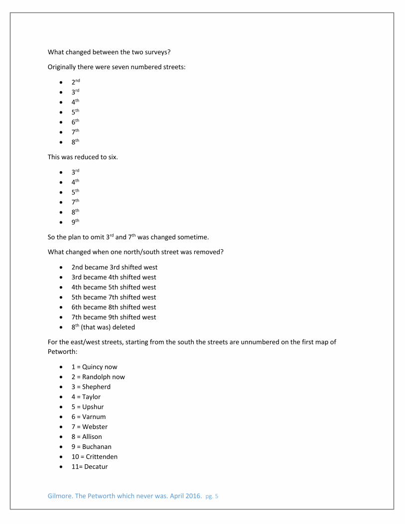
What changed between the two surveys?
Originally there were seven numbered streets:
2nd
3rd
4th
5th
6th
7th
8th
This was reduced to six.
3rd
4th
5th
7th
8th
9th
So the plan to omit 3rd and 7th was changed sometime.
What changed when one north/south street was removed?
2nd became 3rd shifted west
3rd became 4th shifted west
4th became 5th shifted west
5th became 7th shifted west
6th became 8th shifted west
7th became 9th shifted west
8th (that was) deleted
For the east/west streets, starting from the south the streets are unnumbered on the first map of
Petworth:
1 = Quincy now
2 = Randolph now
3 = Shepherd
4 = Taylor
5 = Upshur
6 = Varnum
7 = Webster
8 = Allison
9 = Buchanan
10 = Crittenden
11= Decatur
Gilmore. The Petworth which never was. April 2016. pg. 6
12 = xDelafield -- created 19177
13 = Emerson
14 = Farragut
15 = Gallatin
16 = Hamilton
Originally there were 111 blocks (squares) and reservations, now there are approximately 117 squares.
Ironically the streets are all 90 feet wide and the avenues 120 feet as they should have been under the
1888 law (except the later addition of Delafield). Minor streets of 40 to 60 feet were authorized by
legislation in 1905, partly in an attempt to eliminate alleys.
7 The revised layout of Petworth included some squares which were extra “tall” 450’ N/S and 90’ E/W
rather than 300’ N/S and 90’ E/W. In 1917 Delafield Place was created by dedication of land for creation
of a minor street (only 60 feet wide). This restored the east/west street which had been deleted in the
later Petworth plat.
Gilmore. The Petworth which never was. April 2016. pg. 7
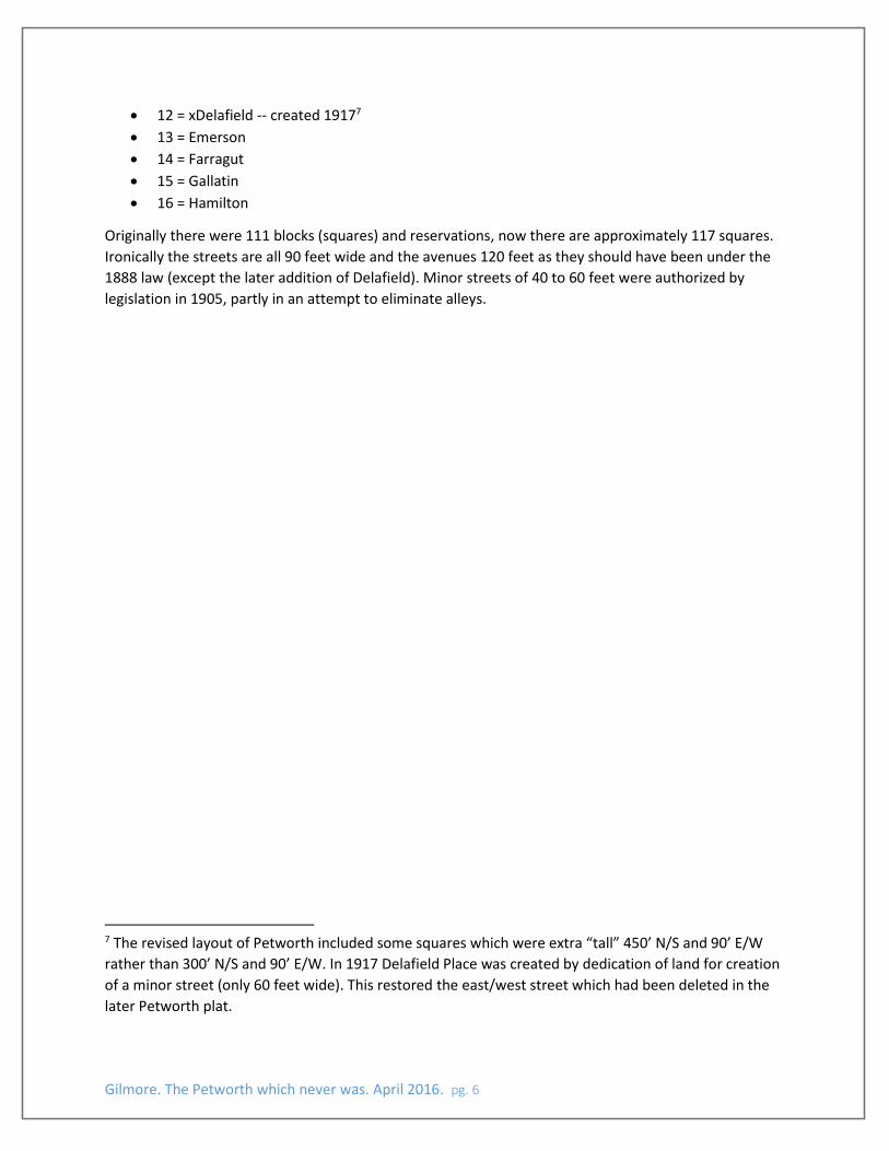
Map of first and second surveys of Petworth superimposed.
Gilmore. The Petworth which never was. April 2016. pg. 8
1903 Baist Atlas page showing Petworth:
Gilmore. The Petworth which never was. April 2016. pg. 9
Plat showing creating of Delafield in 1917:
Being isolated from much of the rest of Washington, development was slow to come to Petworth. Some
1893 images of Newman Row recently surfaced on the Prince of Petworth blog (location noted on map).
By 1895 Cecil Barr of New York snarked in the Washington Post about “the ancient city of Petworth,”
and that “the business section is confined to an abandoned peanut stand at the terminus of the electric
[rail]road.…”8
In 1899 some sewerage had been installed and streets paved, sidewalks built, and the Washington Post
noted that U.S. Commissioner General of Immigration Terence V. Powderly was one of those building a
house (at Rock Creek Church Road and 5th). But in 1902 a Petworth Citizens’ Association was organized.
Petworth’s streets were renamed in 1905 (along with those throughout the rest of the old Washington
County)—old and new names are shown on the maps.
8 Washington Post, Feb. 3, 1895.
Gilmore. The Petworth which never was. April 2016. pg. 10
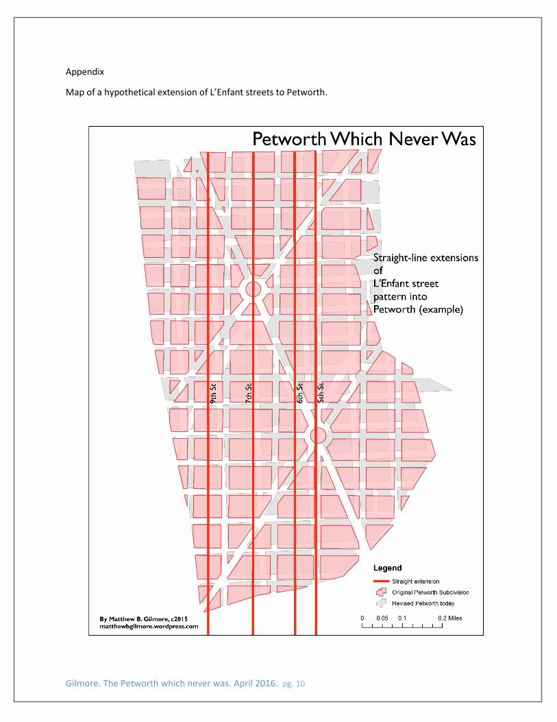
Appendix
Map of a hypothetical extension of L’Enfant streets to Petworth.