+ All Categories
Home > Documents > The prairie potholes of North America · Botany Publication and Papers Botany 2005 The prairie...

The prairie potholes of North America · Botany Publication and Papers Botany 2005 The prairie...

Date post: 25-May-2020
Category:
Upload: others
View: 3 times
Download: 0 times
Share this document with a friend
33
Botany Publication and Papers Botany 2005 e prairie potholes of North America A. G. van der Valk Iowa State University, [email protected] Follow this and additional works at: hps://lib.dr.iastate.edu/bot_pubs Part of the Botany Commons , Hydrology Commons , and the Terrestrial and Aquatic Ecology Commons is Book Chapter is brought to you for free and open access by the Botany at Iowa State University Digital Repository. It has been accepted for inclusion in Botany Publication and Papers by an authorized administrator of Iowa State University Digital Repository. For more information, please contact [email protected]. Recommended Citation van der Valk, A. G., "e prairie potholes of North America" (2005). Botany Publication and Papers. 96. hps://lib.dr.iastate.edu/bot_pubs/96
Transcript

Botany Publication and Papers Botany

2005

The prairie potholes of North AmericaA. G. van der ValkIowa State University, [email protected]

Follow this and additional works at: https://lib.dr.iastate.edu/bot_pubs

Part of the Botany Commons, Hydrology Commons, and the Terrestrial and Aquatic EcologyCommons

This Book Chapter is brought to you for free and open access by the Botany at Iowa State University Digital Repository. It has been accepted forinclusion in Botany Publication and Papers by an authorized administrator of Iowa State University Digital Repository. For more information, pleasecontact [email protected].

Recommended Citationvan der Valk, A. G., "The prairie potholes of North America" (2005). Botany Publication and Papers. 96.https://lib.dr.iastate.edu/bot_pubs/96

The prairie potholes of North America

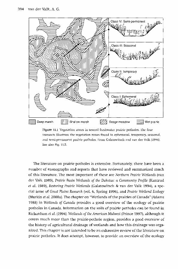
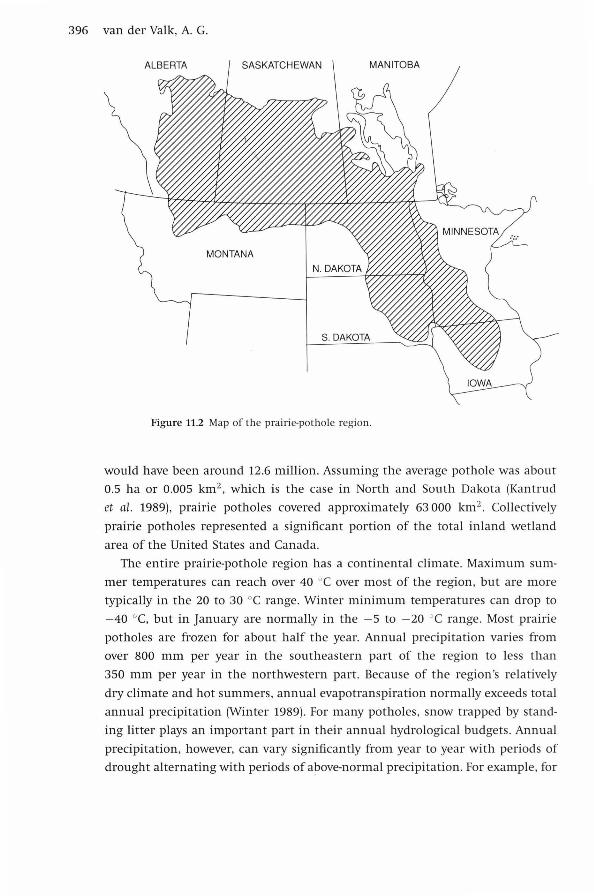
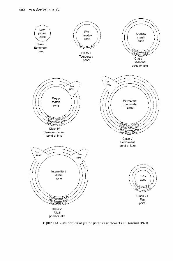
AbstractPrairie potholes or sloughs are small, shallow, palustrine wetlands, common in north-Central North America,with vegetation that is usually herbaceous (Fig. 11.1). In the Aspen Parkland in Canada, which is thetransition zone between the prairies and the boreal forest, aspen (Populus spp.), willows (Salix spp.), andother tree species are often found around the periphery of potholes. The suppression of fire has resulted in treeand shrub invasion of prairie-pothole basins throughout much of the region. Their primary sources of waterare precipitation and groundwater. Most do not have surface inflows or outflows, except during exceptionallywet years when they fill up and surface-water flows temporarily connect them. In most years, water leavesprairie potholes primarily by evapotranspiration and groundwater recharge. During droughts, there is often nostanding water in them at all. Their catchments are typically very small and this, combined with significantchanges in seasonal and annual precipitation, results in rapid and large changes in water levels within andamong years. These water-level changes can result in changes in the species composition and ecosystemfunctions of these wetlands from year to year, especially in deeper potholes. In other words, prairie potholesare very dynamic, shallow depressional wetlands in which plant and animal populations are constantlyadjusting their distribution and population size to changing water levels. Although no single prairie potholewould ever qualify as one of the world's largest wetlands, collectively they are one of the largest and most-important wetland complexes on the planet.

DisciplinesBotany | Ecology and Evolutionary Biology | Hydrology | Terrestrial and Aquatic Ecology

CommentsThis is a chapter from van der Valk, A. G. 2005. Prairie potholes of North America. Pp. 393-423. In TheWorld's Largest Wetlands: Ecology and Conservation, eds. L. H. Fraser and P. A. Keddy. CambridgeUniversity Press, Cambridge, UK. For more information, click here.

This book chapter is available at Iowa State University Digital Repository: https://lib.dr.iastate.edu/bot_pubs/96

11

The prairie potholes of North America

A. G. VAN DER VALK

Iowa State University

Introduction

Prairie potholes or sloughs are small, shallow, palustrine wetlands, com­

mon in north-Central North America, with vegetation that is usually herbaceous

(Fig. 11.1). In the Aspen Parkland in Canada, which is the transition zone between

the prairies and the boreal forest, aspen (Populus spp.), willows (Salix spp.), and

other tree species are often found around the periphery of potholes. The sup­

pression of fire has resulted in tree and shrub invasion of prairie-pothole basins

throughout much of the region. Their primary sources of water are precipitation

and groundwater. Most do not have surface inflows or outflows, except during

exceptionally wet years when they fill up and surface-water flows temporarily

connect them. In most years, water leaves prairie potholes primarily by evapo­

transpiration and groundwater recharge. During droughts, there is often no

standing water in them at all. Their catchments are typically very small and

this, combined with significant changes in seasonal and annual precipitation,

results in rapid and large changes in water levels within and among years. These

water-level changes can result in changes in the species composition and ecosys­

tem functions of these wetlands from year to year, especially in deeper potholes.

In other words, prairie potholes are very dynamic, shallow depressional wetlands

in which plant and animal populations are constantly adjusting their distribu­

tion and population size to changing water levels. Although no single prairie

pothole would ever qualify as one of the world's largest wetlands, collectively

they are one of the largest and most-important wetland complexes on the

planet.

The World's Largest Wetlands: Ecology and Conservation, eds. L. H. Fra~er and P. A. Keddy.

Published by Cambridge University Press. © Cambridge University Press 2005.

393

394 van der Valk, A.G.

~Deep marsh ITIIIIJ Shallow marsh ~ Sedge meadow ~ Wet prairie

Figure 11.1 Vegetation zones in several freshwater prairie potholes. The four

transects illustrate the vegetation zones found in ephemeral, temporary, seasonal,

and semi-permanent prairie potholes. From Galatowitsch and van der Valk (1994).

See also Fig. 11.5.

The literature on prairie potholes is extensive. Fortunately, there have been a

number of monographs and reports that have reviewed and summarized much

of this literature. The most important of these are Northern Prairie Wetlands (van

der Valk 1989), Prairie Basin Wetlands of the Dakotas: a Community Profile (Kantrud

et al. 1989), Restoring Prairie Wetlands (Galatowitsch & van der Valk 1994), a spe­

cial issue of Great Plains Research (vol. 6, Spring 1996), and Prairie Wetland Ecology

(Murkin et al. 2000a). The chapter on "Wetlands of the prairies of Canada" (Adams

1988) in Wetlands of Canada provides a good overview of the ecology of prairie

potholes in Canada. Information on the soils of prairie potholes can be found in

Richardson et al. (1994). Wetlands of the American Midwest (Prince 1997), although it

covers much more than the prairie-pothole region, provides a good overview of

the history of agricultural drainage of wetlands and how this drainage was orga­

nized. This chapter is not intended to be an exhaustive review of the literature on

prairie potholes. It does attempt, however, to provide an overview of the ecology

The prairie potholes of North America 395

of these wetlands and to be a gateway to the rich and extensive literature on

them.

In this chapter, the origin and hydrology of prairie potholes will first be con­

sidered followed by their classification, vegetation (composition, primary pro­

duction, and mineral cycling), and use by waterfowl. Their conservation and

restoration are also briefly reviewed. Because cyclical changes in water levels

and the changes in the flora and fauna that they induce are a defining charac­

teristic of prairie potholes, these cyclical changes will be emphasized.

Geology and climate

As its name implies, the boundaries of the prairie-pothole region

(Fig. 11.2) are defined by both its vegetation and geology. The southern boundary

of the Wisconsin glacial advance is also the southern boundary of the prairie­

pothole region. Those sections of Wisconsin glacial deposits that were histor­

ically covered with grasslands (prairies) and forest-grassland transitions (park­

lands as they are called in Canada) constitute the prairie-pothole region. This

region is estimated to cover about 700 000 km2 (Kantrud et al. 1989). It runs

from central Iowa through western Minnesota and eastern South and North

Dakota and across the southern portions of the Western Canadian provinces of

Manitoba, Saskatchewan, and Alberta (Fig. 11.2).

A complex landscape of moraines, glacial meltwater channels, outwash

plains, and lacustrine plains was created by the retreat of Wisconsin-age glaciers.

For the most part, this new landscape was poorly drained and was covered with

numerous shallow depressions. The size, maximum depth, shape, and connec­

tivity of these shallow depressions were highly variable and were a function of

the type of glacial deposit in which they were located (Adams 1988, Winter 1989,

LaBaugh et al. 1998). Potholes are most abundant in areas of end and stagnation

moraines (up to 90 potholes per km2 ) where the relief can be steep. Their densi­

ties are much lower in areas of hummocky ground moraine (c. 10 to 20 km-2 ),

and outwash plains (c. 5 km-2 ). Regardless of local topography, most potholes

are small and typically less then 1 ha.

In the Canadian portion of the region, there are estimated to be between 4

and 10 million potholes (Adams 1988). In North and South Dakota, there were

estimated to be about 2.3 million in the 1960s (Kantrud et al. 1989). Because so

many had been drained before counts were attempted and many potholes con­

tain no water in dry years and were ignored in some surveys, both the number

of prairie-potholes prior to European settlement, i.e. drainage, and the current

number are unknown. Assuming 18 potholes per km2, as is the case in Canada

(Adams 1988), the total number of prairie potholes prior to European settlement

396 van der Valk, A. G.

ALBERTA SASKATCHEWAN MANITOBA

Figure 11.2 Map of the prairie-pothole region .

would have been around 12.6 million. Assuming the average pothole was about

0.5 ha or 0.005 km2 , which is the case in North and South Dakota (Kantrud

et al. 1989), prairie potholes covered approximately 63 000 km2 • Collectively

prairie potholes represented a significant portion of the total inland wetland

area of the United States and Canada.

The entire prairie-pothole region has a continental climate. Maximum sum­

mer temperatures can reach over 40 °C over most of the region, but are more

typically in the 20 to 30 °C range. Winter minimum temperatures can drop to

-40 °C, but in January are normally in the - 5 to - 20 °C range. Most prairie

potholes are frozen for about half the year. Annual precipitation varies from

over 800 mm per year in the southeastern part of the region to less than

350 mm per year in the northwestern part. Because of the region's relatively

dry climate and hot summers, annual evapotranspiration normally exceeds total

annual precipitation (Winter 1989). For many potholes, snow trapped by stand­

ing litter plays an important part in their annual hydrological budgets. Annual

precipitation, however, can vary significantly from year to year with periods of

drought alternating with periods of above-normal precipitation. For example, for

The prairie potholes of North America 397

Milford, Iowa between 1951 and 2000, annual total precipitation ranged from a

low of 254 mm in 1957 to 1196 mm in 1993, a difference of 942 mm, with a

mean over this period of 725 mm. Because of the small size of pothole catch­

ments, changes in an annual precipitation can result in significant changes in

water levels from year to year (van der Camp & Hayashi 1998). These changes

in water levels can have a profound effect on the species composition, species

distribution, and ecological functions of potholes.

Hydrology

Prairie potholes are depressional wetlands in a geologically new land­

scape that is in the early stages of developing an integrated surface drainage sys­

tem (LaBaugh et al. 1998). Potholes are not yet a part of this developing drainage

system and only infrequently have a stream channel either entering or leaving

them. Although they are often viewed as being isolated basins, this is not actu­

ally true. During wet years, prairie potholes can overflow and become connected

to each other. In effect this is the beginning of the development of an integrated

drainage system that will eventually eliminate these wetlands as this landscape

ages. They are also usually connected to adjacent potholes through groundwater

flows, especially in areas with some relief (see Winter 1989). Depending on their

position in the landscape, and regional and local groundwater flow patterns,

prairie potholes can be groundwater discharge areas, groundwater recharge

areas, or groundwater flow-through wetlands (Winter 1989, LaBaugh et al. 1998,

Rosenberry & Winter 1997, Winter & Rosenberry 1998). Although water levels

in all prairie potholes are affected by changes in annual precipitation to some

extent, potholes with significant groundwater inputs will rarely go completely

dry.

Because the entire prairie-pothole region has a climate in which precipita­

tion varies seasonally and interannually, the water levels in prairie potholes

are constantly changing (Fig. 11.3). Due to a combination of spring runoff and

rain, water levels are highest in the spring and then decline slowly during the

summer. Years of above-normal total annual precipitation are often followed by

below-normal years. These cyclical changes in annual precipitation, "wet-dry"

or "habitat" cycles, are about 10 to 15 years in duration (van der Valk & Davis

1978a, Kantrud et al. 1989).

Prior to European settlement, groundwater tables in the region were often

close to the surface, especially in the southern part of the region (Prince 1997).

This had an adverse effect on crop growth because the saturated zone just below \

the surface of the soil was anaerobic and crop roots would not grow in it.

398 van der Valk, A. G.

Seasonal wetland 200

- 150 E ~ ..c li <ll -0 ~

<ll (ii 3:

E ~ ..c li <ll -0 ~

<ll (ii 3:

\\ 100

\ 1 50

0

Permanent wetland

200

~\ \ 150

100 \ 50

\\'\\ \\ \\ \ \\\ ~ v \ ~\\

0 co 0 N ... <D co 0 N ... <D co 0 N ... <D co <D .... .... .... .... .... co co co co co "' "' "' "' "' ~ ~ ~ ~ ~ ~ ~ ~ ~ ~ ~ ~ ~ ~ ~ ~

Year

Figure 11.3 Water level changes in a small, seasona l (S109) and la rge, permanent

(SSO) prairie pothole at the St. Denis Nat ional Wildlife Refuge, Saskatchewan,

Canada. Th e gaps in the records indicate periods when these wetlands were frozen

and no data were collected . Adapted from van der Camp and Hayashi (1998).

The presence of potholes also made it difficult to move equipment around a

farm and limited the size of some types of equipment, e.g. plows. Potholes were

drained almost exclusively to create more farmland or to improve the field layout

of existing farms. Drainage required the establishment of drainage networks ,

either using surface channels (northern parts of the region) or drainage tiles

(southern parts) to create a man-made network that joined these wetlands to the

existing natural drainage networks. Prince (1977) provides a detailed description

of the legal organization, m ethodology, and extent of drainage in the entire

American Midwest, which includes the American portion of the prairie-pothole

region.

The prairie potholes of North America 399

Classification

Stewart and Kantrud (1971) working in North Dakota devised a scheme

for classifying prairie potholes that is based on the type of wetland vegetation

found in the deepest portions of their basins (Fig. 11.4). They recognized five

types of prairie potholes: Class 1, ephemeral ponds (with wet prairie in deepest

areas); Class II, temporary ponds (wet meadow); Class III, seasonal ponds (shallow

marsh); Class IV, semi-permanent ponds (deep marsh); Class V, permanent ponds

(submersed aquatics). (The Class-I wetland type of Stewart and Kantrud [1971]

is no longer considered a wetland, but a type of wet prairie.) The number of

vegetation zones in a basin depends on its maximum water depth (Figs. 11.1

and 11.4). prairie potholes also differ in water chemistry (saline versus brackish

water) with saline potholes most common in the Canadian Prairie Provinces.

Although the Stewart and Kantrud (1971) classification of prairie potholes has

now been supplanted by newer American (Cowardin et al. 1979) and Canadian

(National Wetlands Working Group 1988) national wetland classification systems,

it, nevertheless, remains a regionally useful system.

As noted, the maximum water depth in a basin is the single-most-important

feature of potholes (Stewart & Kantrud 1971). The deepest potholes, i.e. Class V

(Fig. 11.4), have four different types of wetland vegetation or zones. Starting in

the deepest part of the basin, these four zones are described below.

1. Open-water zone. This is the deepest zone and it is permanently flooded.

Submerged vascular aquatic plants are the dominant species, e.g. species

of Potamogeton, Najas, Myriophyl!um, Utricularia, Ceratophyl!um, etc.

2. Deep-marsh zone. This zone is semi-permanently flooded and only goes

dry during drought years. The vegetation is dominated by tall emer­

gents, e.g. typically species of Typha and Scirpus, with an understory of

submerged aquatic and small free-floating species (e.g. Lemna, Spirodel!a,

and Ricciocarpus).

3. Shallow-marsh zone. This zone is only seasonally flooded, typically in the

spring. The vegetation tends to be dominated by tall grasses and sedges

(Carex spp.) with a sprinkling of forbs.

4. Wet-meadow zone. This zone is only temporarily flooded for a few weeks

in the early spring. The vegetation is dominated by a mix of medium­

height grasses, sedges, and rushes (Juncus spp.), and many species of

forbs. Trees and shrubs may also be found in this zone and may be the

dominant species in some potholes.

Potholes from classes IV, III and II (Fig. 11.4) have three, two and one wetland vege­

tation zones, respectively. The boundaries between adjacent zones are sometimes

400 van der Valk, A. G.

Class I Ephemeral

pond

Class IV Semi-permanent

pond or lake

Class II Temporary

pond

I',~~ /_,\ 1 Fen ~~~ -------~ ~ / I ' I \ zone ,,.... Fen ;

\ zone / \ I

Intermittent alkali zone

Class VI Alkali

pond or lake

Class Ill Seasonal

pond or lake

Permanent open-water

zone

Class V Permanent

pond or lake

Class VII Fen

pond

Figure 11.4 Classification of prairie potholes of Stewart and Kantrud (1971).

The prairie potholes of North America 401

difficult to delineate and normal zonation patterns can be replaced by a variety

of atypical patterns caused by the deletions of one or more zones, doubling of

zones, or inversions of zones due to water-level fluctuation patterns. Atypical

zonation patterns can often be used to reconstruct the recent hydrology of a

prairie pothole (Kantrud et al. 1989).

Vegetation

Changes in water levels caused by changes in total annual precipitation

have a major impact on plant and animal populations in the deeper prairie

potholes, i.e. classes N and V (Fig. 11.4). Among the first researchers to recognize

that changes in these wetlands were cyclical were Weller and Spatcher (1965).

They outlined a five-stage habitat cycle: dry marsh (drawdown), dense marsh

(several years after reflooding), hemi-marsh (50% emergent, 50% open water),

open marsh (more than 50% open water), and open-water marsh (emergents

largely or completely eliminated). The open-water marsh persists until the next

drought, which lowers water levels and eventually exposes the marsh sediments.

This marks the start of the next dry-marsh stage. Weller and Spatcher (1965) also

noted that water-level changes and herbivory by muskrats, which contributed to

the elimination of emergent vegetation during high-water years, caused these

cycles. They also documented the impact of water-level and vegetation changes

on bird usage of prairie potholes. These cyclical changes in prairie potholes came

to be known as "habitat" or "wet-dry" cycles.

Subsequent studies by van der Valk and Davis (1976, 1978a), Pederson (1981),

Pederson and van der Valk (1985), and Poiani and Johnson (1989) established the

central role of seed banks (viable seed in the sediments) in these wetlands for

the persistence of plant species from one cycle to the next and for the ability

of the vegetation in these wetlands to adjust quickly to different water depths

during the cycle. They emphasized the importance of drawdowns, the dry-marsh

stage, in the habitat cycle for the re-establishment of emergent species and

for mudflat annuals, a group of species that are only found in these wetlands

during drawdowns. Figure 11.5, which is taken from van der Valk and Davis

(1978a), outlines the vegetation cycle as it was understood in the late 1970s. They

simplified the cycle proposed by Weller and Spatcher (1965) by combining the

hemi-marsh and open-marsh stages, during both of which emergent vegetation

is declining. The four stages in the van der Valk and Davis vegetation cycle

are the dry marsh, regenerating marsh (= dense marsh), degenerating marsh

(= hemi-marsh and open marsh), and lake marsh(= open-water marsh).

The classic habitat cycle as described above is mainly a feature of the deeper

and larger prairie potholes, i.e. classes N and V, in which a significant range of

402 van der Valk, A. G.

Dry marsh

Droughl or drawdown

Mudllat

Submersed and free floating

Lake marsh

Normal

...

Marsh seed bank

Clfl muskrat

damage

- - • Seed inputs

~ Seed germination

" k " "

" "",,,."' Emergent, ,,,. - submersed and

free floating

15.enescence disease insects high water

.... .... Emergent,

''< submersed a~d ', ~e: floating

........ ........

....

Degenerating marsh

Figure 11.5 Idealized habitat cycle in a semi-permanent prairie pothole (van der

Valk & Davis 1978a). See also Fig. 11 .1.

water levels (c. 1.5 to 2 m) can occur. Only in deep potholes can water levels in

wet years become deep enough, for long enough, to eliminate emergent plant

species. Habitat cycles also occur in shallower potholes , but they do not produce

such marked changes in the composition and distribution of vegetation. Their

impact is primarily on understory plant species and the fauna.

The cyclical changes in the vegetation in potholes are a type of succession,

herein defined as a change in the floristic composition of the vegetation in an

area from one year to another (van der Valk 1981, 1982, 1985, 1987). According

to this definition, succession occurs whenever a new species becomes estab­

lished or a species is extirpated. Several models of succession in potholes have

been proposed . The earliest was the critical life-history model of van der Valk

(1981). This qualitative model uses expected or effective life span, propagule

longevity, and propagule establishment requirements of plant species to pre­

dict the species compos1t10n of a wetland during various stages of a habi­

tat cycle. Poiani and Johnson (1993) developed a computer simulation model

in which a vegetation submode! that determines the responses of six classes

of prairie-wetland species to water-level changes is linked to a hydrology sub­

mode! that estimates water depths from precipitation and evapotranspiration

data.

The prairie potholes of North America 403

Water depth is usually the most-important determinant of the position of

plant species along elevation gradients in freshwater wetlands (Shay & Shay 1986,

van der Valk & Welling 1988). In order to develop spatially explicit models at the

species level, a model was needed that incorporated the water-depth tolerances

of each species. Unfortunately, with a few exceptions (e.g. Squires & van der

Valk 1992), there is little experimental data on the water-depth tolerances of

most species in northern prairie wetlands. Nevertheless, two such models of

the responses of emergent species to water-level changes have been developed

for the Delta Marsh [located on the south shore of Lake Manitoba (98° 231 W,

50~ 11 1 N)]. De Swart et al. (1994) developed a series of logistic regression models

to predict the distribution of dominant emergent species after changes in water

levels. Seabloom et al. (2001) developed a cellular automaton model in which

adult and seed distributions, and a set of rule-based functions, determine the

fate of each emergent species and the annual guild within each cell of a grid

covering the wetland. Seabloom et al. (2001) have evaluated the strengths and

weaknesses of these two models. The models of Poiani and Johnson (1993), De

Swart et al. (1994), and Seabloom et al. (2001), although they are pioneering

efforts, have demonstrated that it is possible to develop models that can reliably

predict changes in the composition and distribution of vegetation in prairie

wetlands during habitat cycles.

Primary production and mineral cycling

The cyclical changes in the vegetation during a habitat cycle signifi­

cantly alter the primary production, secondary production, and mineral cycling

in prairie potholes (van der Valk & Davis 1978b, 1980, van der Valk 1994, Murkin

et al. 2000a, 2000b, van der Valk & Murkin 2001). These functional changes over

an entire cycle have never been measured in a prairie pothole, although some

data on production and mineral cycling are available (van der Valk & Davis

1978b, 1980, Davis & van der Valk 1978a, 1978b, 1978c). They were quantified

for an experimentally induced habitat cycle that was carried out over a ten-year

period in the Delta Marsh (Murkin et al. 2000a). Although the Delta Marsh is

a lacustrine marsh, it is in the prairie-pothole region and, prior to the estab­

lishment of water-control structures to control flooding, it underwent the same

kinds of water-level fluctuations as permanently flooded prairie potholes (Batt

2000). From the primary production data from the Delta Marsh, it is possible

to estimate the relative magnitude of the changes in standing biomass, nitro­

gen, and phosphorus during a cycle (Kadlec et al. 2000, Murkin et al. 2000b, van

der Valk 2000, van der Valk et al. 2000). The Delta Marsh is at the northeastern

edge of the prairie-pothole region. Consequently, the primary production in this

wetland is lower than in potholes further south.

404 van der Valk, A. G.

Dry marsh

During the dry-marsh stage, when this wetland was drawn down for

two years, total macrophyte biomass was about 440gm-2 of which 365gm-2

was above ground. Annual species made up 50% or more of the total biomass.

Newly recruited Phragmite5 australis and Scirpus lacustris contributed most of the

rest of this biomass. Mean below-ground biomass was around 75 g m-2 or 17%

of the total.

Regenerating marsh

During the regenerating stage, mean total biomass reached a maximum

of 4 75 g m-2 . Above-ground biomass (220 g m-2 ) was actually lower than during

the dry-marsh stage and the main contributors to it were emergents and sub­

mersed aquatics. The increase in total biomass was due primarily to increases in

the below-ground biomass of emergent species. Mean below-ground biomass was

255gm-2 or 54% of the total. The main change in primary production with the

reflooding of the wetland was a 3-fold increase in the amount of below-ground

biomass as the dominant species switched from annuals and emergent seedlings

to fully grown emergents.

Degenerating marsh

Mean total biomass declined (380 g m-2 ) during the degenerating-marsh

stage due to the localized or complete extirpation of emergent species (espe­

cially Scolochloa festucacea and Scirpus lacustris). Above-ground biomass declined

to 155 g m-2 and below-ground biomass to 225 g m-2 • Algal production, how­

ever, increased during this stage. The emergent species that continued to grow

during this stage continued to increase their below-ground biomass.

Open marsh

During the open-marsh stage, when water levels were over 1 m above

the long-term mean water level, the emergent vegetation was mostly extirpated

and was replaced by submerged aquatics and metaphyton. Although there was

little above-ground emergent biomass during the first and second years of deep

flooding, below-ground biomass persisted at high levels until the fall of the

second year of deep flooding. After two years of open water, total biomass was

at the lowest level found, 85gm-2 - of which 60 gm-2 or 70% was above ground.

Algal production, however, is highest during this stage.

Over the entire simulated wet-dry cycle, above-ground biomass did not vary

as much as previously estimated by van der Valk and Davis (1978b); it varied

about 6-fold, not the 20-fold predicted.

The prairie potholes of North America

Table 11.1 Estimated mass of N (kgha- 1) in the major pools during

the growing season in the four stages of an idealized wet-dry

cycle.

Stage

Pool Dry Regenerating Degenerating Lake

Macrophytes

Above ground 73 44 31 12

Below ground 15 51 45 5

Total 88 95 76 17

Algae 5 14 12-15"

Invertebrates 2 0.6-3

Surface water

Inorganic 1 0.8-2

Organic 17 22 10-30

Pore water

Inorganic 11 18 6-23

Organic 29 32 26-30

Total 88 160 164 73-120

a Low estimate from reference cells; high estimate from second year of

deep flooding.

These changes in biomass during a habitat cycle resulted in major changes

in the size of nutrient-storage compartments (water, plants, litter, invertebrates,

vertebrates, etc.) and movements of nutrients among these compartments, i.e. in

nutrient cycles (Tables 11.1 and 11.2). Other than the soils, the largest compart­

ment for both nitrogen and phosphorus during most of a habitat cycle is the

vegetation, except in the lake stage when the surface-water compartment may

be larger. Although there are changes in the size of algal, invertebrate, and verte­

brate compartments during the cycle, they are minor when compared with the

changes in the vegetation. In short, it is changes in the size of the macrophyte

compartment and fluxes into and out of this compartment that drive mineral

cycling in prairie potholes (Murkin et al. 2000b).

Waterfowl

The prairie-pothole region is one of the major waterfowl-breeding areas

in North America (Batt et al. 1989). It is also a major migration corridor in the

fall and spring for ducks, geese, and other birds. Because most potholes are iso­

lated from lakes and streams in the region, go dry periodically, and are largely

405

406 van der Valk, A.G.

Table 11.2 Estimated mass of P (kg ha- 1) in the major pools during

the growing season in the four stages of an idealized wet-dry cycle.

Stage

Pool •Dry Regenerating Degenerating Lake

Macrophytes

Above ground 27 7 5 2

Below ground 2 5 5 0.5

Total 29 12 10 2.5

Algae 1.5 1.8 1.6-2.2"

Invertebrates 0.2 0.1 0.1-0.3

Surface water

Inorganic 0.3 0.4 0.8-1.5

Organic 0.3 0.4 0.3-0.7

Pore water

Inorganic 2.6 3.3 1.6-5.3

Organic 0.7 0.8 0.5-1.0

Total 29 17 17 7-13

0 Low estimate from reference cells; high estimate from second year of

deep flooding.

anaerobic in areas covered with emergent vegetation (Rose & Crumpton 1996),

they usually do not contain fish - except possibly a couple of species of minnows

that can tolerate low oxygen levels (Peterka 1989). The absence of fish makes all

of the invertebrate production in these wetlands available to waterfowl. This is

especially important early in the breeding season when female ducks require

large amounts of protein in their diets while laying eggs (Swanson & Duebbert

1989, Alisauskas & Ankney 1992, Krapu & Reinecke 1992). The lack of fish in

prairie-pothole food chains is a major reason why they are such a productive

waterfowl-breeding habitat. The prairie region produces about 50% of the game

ducks (Smith 1995), but makes up only 10% of the remaining waterfowl-breeding

habitat in North America. The absence of fish also makes potholes a productive

breeding habitat for amphibians. In potholes with fish, amphibian eggs and lar­

vae become prey items for many fish species. When potholes have been connected

to large lakes, as has happened in the Iowa Great Lakes region, amphibian pop­

ulations in these formerly isolated potholes have declined significantly (Lannoo

1996).

Twelve of the thirty-four species of North American ducks are common breed­

ers in the region. The prairie-pothole region alone has about 60% of the breed­

ing population of seven species (mallard, gadwall, blue-winged teal, northern

The prairie potholes of North America 407

Table 11.3 Size of total duck breeding population in the

prairie-pothole region and numbers of potholes with water in

May, 1986-95. Adapted from Smith (1995).

Number of Number of potholes with water

Year breeding ducks Total United States Canada

1986 18429000 5 760000 1735000 4025000

1987 16 521 000 3 872 000 1348000 2 524000

1988 13 515 000 2 901 000 791 000 2110 000

1989 12 725000 2 983 000 1290000 1693 000

1990 13 399 000 3 508 000 691000 2 817 000

1991 11944000 3 200000 706000 2494000

1992 14 256 000 3 609000 825000 2 784 000

1993 12 180 000 3 611 000 1350000 2 261000

1994 18 997 000 5 985 000 2 216 000 3 769000

1995 21892 000 6 336 000 2443 000 3 893 000

Mean 15 385 800 4176 500 1 339 500 2 837 000

shoveler, northern pintail, redhead, and canvasback) in most years (Smith 1995).

The number and distribution of ducks in the region each year depends on water

conditions (Batt et al. 1989). Population sizes and reproductive success of these

ducks are positively correlated with the number of potholes holding water in

May and July Oohnson & Grier 1988, Batt et al. 1989). During drought years,

many ducks move to other parts of the continent, e.g. to the boreal-forest or

tundra regions Oohnson & Grier 1988). Northern pintail and blue-winged teal

are more affected by droughts because they tend to use temporary and sea­

sonal wetlands, whereas canvasbacks and lesser scaup - which use deeper, semi­

permanent, and permanent wetlands - are less likely to be displaced, except dur­

ing severe drought. Reproductive success is generally reduced during droughts

because of lower nesting success and lower survival rates of ducklings. For exam­

ple, from 1986 to 1995, spring water conditions in the prairie-pothole region,

as measured by the number of potholes with water, ranged from: good in

1986 (more than 5 million potholes with water); to very poor during 1988-93

(3.6 million or less), a prolonged drought period; to excellent by 1994-95

(Table 11.3). During this decade, the mean number of breeding ducks was

15 385 000 (Table 11.3), 16% lower than the long-term average (1955-95) of

18166 000. The number of breeding ducks was lowest (1194400 in 1991) during

the 1988-93 drought. With the end of the drought in '1994-5, breeding-duck pop­

ulations increased rapidly and were estimated to be 21 892 000 by spring 1995,

408 van der Valk, A. G.

which is higher than the long-term average. Drought during 1988-93 reduced

the amount of wetland habitat available to breeding waterfowl. This reduced

waterfowl population sizes because of the displacement of ducks, particularly

pintails and mallards, to other regions. The rebound of duck species populations

in 1994-5 was due to the' refilling of the potholes.

Regionally, the effects of droughts on breeding-duck population sizes are

highly species specific (Table 11.4). Lesser-scaup populations were halved by the

drought in 1989 versus 1986, but had returned to pre-drought levels in 1995.

Mallard, northern-shoveler, and blue-winged-teal populations (Table 11.4) were

low during the drought years (1988-93) and increased in the wet years (1994-5).

Gadwall numbers dropped only slightly below their long-term average during

1987-8 and in 1995 gadwall numbers were twice their long-term average. Gadwall

are more-closely associated with the prairie-pothole region than other ducks,

with more than 90% of the US gadwall population normally found in the region.

Pintails had record lows during the drought years and showed a doubling of

the populations from 1993 to 1994. Redhead, canvasback, wigeon, and green­

winged-teal populations declined to some extent during the drought compared

with other species, but did increase in 1994 - and especially 1995 - to population

sizes larger than their long-term means.

Waterfowl and habitat cycles

Changes in water levels result in changes in vegetation cover and struc­

ture, and in type of food available within a wetland; these changes in turn

affect the number and kinds of birds found in a wetland at any given time in a

habitat cycle (Weller 1994, Murkin & Caldwell 2000). Collectively, these changes

in bird use during the habitat cycle in a given wetland produce the overall

changes in waterfowl populations that occur over the entire region. Weller and

Spatcher (1965) documented changes in bird use during habitat cycles and the

Delta Marsh experimental study documented similar changes as well as changes

in plant cover and food sources on which the birds rely (Murkin et al. 1997,

Murkin & Caldwell 2000).

Dry marsh

The vegetation during the dry-marsh stage is a combination of annu­

als and newly established emergent species. Initially this vegetation may have

little cover value because it is too sparse and low. Exposed mudflats are com­

mon at the beginning of the dry-marsh stage and areas of mudflats may remain

during the entire stage in some cases. These mudflats are ideal feeding places

for many shorebirds. They feed on the invertebrates and seeds in the mud­

flats. As the soil dries out and the vegetation becomes denser and taller, many

Table 11.4 Breeding populations (in thousands) of ten duck species in the prairie-pothole region in 1986-95 (Smith 1995).

Year

Species 1986 1987 1988 1989 1990 1991 1992 1993 1994 1995 TYM LTM

Mallard 3900 3678 2726 2957 2800 2863 3326 3188 4516 5352 3531 4678

Blue-winged teal 3892 2800 2761 2438 2318 3113 3572 2409 4199 4847 3235 3594

Gadwall 1463 1244 1237 1301 1458 1443 1916 1636 2201 2734 1663 1293

Northern pintail 1655 1398 674 1002 966 524 905 1075 2066 1805 1207 3112

American wigeon 544 440 440 398 508 510 685 504 763 852 564 1021

Northern shoveler 1609 1349 930 930 1080 1078 1195 1290 2187 2177 1382 1444

Lesser scaup 1311 856 1023 621 741 822 919 738 1020 1253 930 1107

Redhead 509 479 398 458 416 349 498 403 581 855 495 512

Green-winged teal 297 307 345 309 356 331 403 281 574 686 389 530

Canvasback 285 309 240 201 238 247 215 210 293 491 273 329

TYM, ten-year mean; LTM, long-term mean (1955-95).

410 van der Valk, A.G.

terrestrial and semi-terrestrial invertebrates become more common. This in turn

attracts upland birds such as bobolinks (Dolichonyx oryzivorus), meadowlarks (Stur­

nela neglecta), and mourning doves (Zenaida macroura). Many small mammals may

also become established during the dry-marsh stage, including deer mice (Pero­

myscus manicu!atus). During' the dry-marsh stage, some dabbling ducks may nest

in the wetland ifthere is permanent water nearby and some upland bird species

may rest the taller patches of vegetation. Most of the species that are typically

found in prairie potholes are absent during the dry-marsh stage and are replaced

by an assemblage of terrestrial species. The longer this stage lasts, the more ter­

restrial this assemblage becomes.

Regenerating marsh

The reflooding of the wetland makes it suitable habitat again for wet­

land invertebrate and vertebrate species. Aquatic invertebrates in the soil, on

plants, and in the water column quickly return. Algal populations often flou­

rish and can become very abundant, especially the metaphyton. The spread of

emergents during this stage can result in very-dense vegetation over all or most

of the wetland, depending on water levels. Submerged aquatic macrophytes are

often common during the first year or two before being shaded out by emergents.

Wetlands during the regenerating stage are re-colonized by breeding waterfowl

and other water birds, e.g. rails and coots, as both suitable food and cover are

again available for them. Marsh wrens and blackbirds, which nest in emergents,

also return and muskrats become re-established.

Degenerating marsh

The decline in emergent species marks the onset of the degenerat­

ing marsh. This decline is due to high water levels, or muskrat feeding and

lodge building, or some combination of these. The early stage of the degener­

ating marsh, when there is a mix of open water and emergent vegetation, is

the most-favorable stage for the majority of animal species in prairie potholes,

especially birds. Submerged aquatic vegetation dominates the open-water areas.

Invertebrate populations shift from those characteristic of temporary water to

those found in permanent water (e.g. amphipods and chironimids). Diving ducks

become more common during this stage. Muskrats may also become very abun­

dant in this stage, and their activities may greatly accelerate the rate of loss of

emergent species.

Lake marsh

With the continued decline of emergent populations, a point is reached

where these species are reduced to a thin fringe around the edge of the wetlands.

The prairie potholes of North America 411

The wetland now resembles a pond or lake. The invertebrate fauna in this stage

is dominated by benthic species, and there is little cover or shelter because

of the absence of emergents. Submerged aquatics and planktonic algae are the

dominant plants. Fish may also become established or become more abundant if

already present. Overall, food sources for most birds are limited. Only birds that

use open water, e.g. diving ducks, are found during this stage. Other common

wetland species, e.g. dabbling ducks, no longer use the wetland except as a

stopover during migration. Some relict populations ofrails, coots, and blackbirds

may remain in the emergent fringe along the edge.

Potholes as nutrient sinks

As with many other kinds of wetlands (Kadlec & Knight 1996), prairie

potholes can remove nutrients from the water that enters them (Neely & Baker

1989, Crumpton & Goldsborough 1998). Consequently, potholes can reduce non­

point-source pollution from farmland, which is the major source of nutrients

entering lakes and streams in the prairie-pothole region (van der Valk & Jolly

1992). Because so many prairie potholes have been drained, the restoration of

prairie potholes is often proposed as a cheap and efficient way to treat runoff

in agricultural watersheds (Galatowitsch & van der Valk 1994).

Published data on the fate of inorganic nitrogen and phosphorus in agri­

cultural runoff entering prairie potholes is still limited, especially for natural

wetlands. The best long-term data set comes from Eagle Lake, Iowa. This wet­

land receives most of its surface inputs through two large drainage ditches at

the south end and its only surface outflow is over a low dam at the north

end (Davis et al. 1981). As the data from this study indicate (Table 11.5), Eagle

Lake was a perfect nutrient sink for nitrogen (both nitrate and ammonia) and

phosphate for three out of four years. The main reason for this was that this

wetland had no outflows for three years. However, during the fourth year the

flow in drainage tiles increased significantly and nutrient inputs also increased

as the drought ended and there were outflows from the wetland. Nevertheless,

Eagle Lake remained a nutrient sink in year four, and its nutrient removal effi­

ciency was about 80% for ammonia, 85% for nitrate, and 20% for phosphate.

However, as with most wetlands, when soluble organics are considered the

situation is very different. For example in 1979 when there was an outflow

from Eagle Lake, inputs of soluble carbon were about 300 kg ha- 1 while out­

puts were 516 kg ha- 1• Eagle Lake was acting as a source for dissolved organic

compounds.

Eagle Lake and subsequent studies (Crumpton &' Goldsborough 1998) have

demonstrated that prairie potholes are good sinks for inorganic nitrogen

412 van der Valk, A.G.

Table 11.5 Inputs and outputs of water (mm) and nutrients (kg ha- 1) for

Eagle Lake, Iowa. Adapted from Davis et al. (1981).

1976 1977 1978 1979

Water

Preci pi ta ti on 575 963 709 944

Surface inflows 33 36 163 1620

Total inputs 608 999 872 2564

Surface outflow 0 0 0 1758

Ammonia

Precipitation 4.0 6.7 5.0 6.6

Surface inflows 0.1 0.5 0.8 2.5

Total inputs 4.1 7.2 5.8 9.1

Surface outflow 0 0 0 2.0

Nitrate

Precipitation 4.1 6.8 5.0 6.7

Surface inflows 7.1 3.7 25.4 202.8

Total inputs 11.2 10.5 30.4 209.5

Surface outflow 0 0 0 29.8

Phosphate

Precipitation 0.20 0.33 0.24 0.32

Surface inflows 0.05 0.18 0.75 3.20

Total inputs 0.25 0.51 0.99 3.52

Surface outflow 0 0 0 2.81

compounds, but not necessarily ideal sinks for inorganic phosphorus. Since

nitrate is the major nutrient in the runoff from farmland in much of the region

(Neely & Baker 1989), existing potholes - and restored and created potholes - have

the potential to reduce non-point-source pollution problems in the region.

Conservation

Fortunately, the prairie-pothole region is not experiencing rapid pop­

ulation growth or development. In fact, the number of people living in many

rural parts of the region is declining. Consequently, development pressure on

prairie potholes is not as intense as it is for many other kinds of wetlands

around the United States and the rest of the world. The main threat to prairie

potholes remains agricultural drainage. In the United States, such drainage has

mostly ceased for several reasons. These include: the end of federal subsidies for

drainage; the judicial ruling that these wetlands are protected under the Clean

Water Act; and the Swampbuster provision of the 1985 Food Security Act. The

The prairie potholes of North America 413

latter prevents farmers from obtaining a variety of government farm subsidies if

they drain wetlands on their property. The use of prairie potholes by migratory

waterfowl provided a legal rationale, the Migratory Bird Rule, used to justify the

protection of isolated wetlands - i.e. wetlands not contiguous with or adjacent

to navigable water - by the Clean Water Act under Section 404. Most prairie pot­

holes are not associated with navigable waters (van der Valk & Pederson 2003).

In 2002, the US Supreme Court's decision in the case of the Solid Waste Agency

of Northern Cook County versus US Army Corps of Engineers, the "SWANCC

decision," invalidated the use of the Migratory Bird Rule. The SWANCC decision

could result in a significant reduction in the legal protection of prairie potholes

from drainage (van der Valk & Pederson 2003). Although Swampbuster will con­

tinue to prevent the drainage of potholes in the United States in the short term,

the removal of most potholes from protection under the Clean Water Act will

make it easier to provide exemptions to and to repeal Swampbuster.

Because the prairie-pothole region has long been recognized as a major breed­

ing area for waterfowl, there has been a significant movement to protect pot­

holes from drainage since the 1930s. Ducks Unlimited has been the most visible

and effective private organization working to protect wetlands in the United

States and Canada, and the US Fish and Wildlife Service and Canadian Wildlife

Service - and their state and provincial counterparts - have been the most visible

and effective government entities. Initially, the main efforts of these organiza­

tions were to preserve existing potholes through establishing wildlife refuges

and Waterfowl Protection Areas (WPAs). "Duck Stamps" issued by various gov­

ernment agencies funded the acquisition of pothole areas to protect them from

drainage. Hunters were required to buy these stamps before they could legally

hunt waterfowl.

In 1986, Canada, the United States, and Mexico adopted the North American

Waterfowl Management Plan. This major new international initiative brought

together a consortium of private organizations and government agencies with

the primary goal of conserving wetlands and increasing waterfowl and other

wetland bird populations. The North American Waterfowl Management Plan

resulted in the formation of a number of "joint ventures," one of which is

the Prairie Pothole Joint Venture that has been operating since 1987. Through

a variety of cooperating organizations (federal agencies, state and provincial

agencies, and Ducks Unlimited) and federal and state conservation and farm

programs, including various US Department of Agriculture land set-aside pro­

grams, the Prairie Pothole Joint Venture has worked to protect and increase

wetland acreage by buying land, by conservation easements, and by restoring

wetlands on private land. The Prairie Pothole Joint Venture has well-defined habi­

tat objectives (hectares of land to be protected, restored, or enhanced) as well as

414 van der Valk, A. G.

waterfowl-population objectives (number of breeding and migrating ducks and

a target recruitment rate).

Restoration

The restoration of prairie potholes in the United States has increased

dramatically because agricultural land set-aside programs either allowed farm­

land in the prairie-pothole region to be restored to wetlands or, more recently,

required that the farmland be restored to wetlands. Galatowitsch and van der

Valk (1994) have reviewed the techniques used to restore prairie potholes. Gray

et al. (1999) have reviewed restorations in the Canadian part of the region. Over

the last 15 years or so, thousands, perhaps tens of thousands, of prairie potholes

have been restored. Wetland restorations typically have three stages: environmen­

tal restoration, vegetation restoration, and ecosystem restoration. Environmental

restoration involves restoring the hydrology to something like pre-drainage con­

ditions. Vegetation restoration involves re-establishing the indigenous species

that were formerly found in the wetland. Ecosystem restoration involves restor­

ing the functional attributes of the wetland such as its primary production, food

chains, and mineral cycles. Most wetland restorations assume that this last stage

will occur automatically and stop with the establishment of suitable vegetation.

Unfortunately prairie-pothole restoration usually stops at the environmental­

restoration stage. Restoring the hydrology in drained prairie potholes is done

by disrupting drainage-tile lines or filling in drainage ditches (Galatowitsch &

van der Valk 1994). Although environmental restoration is simple in theory, it

can be much more complex in reality. Wetlands to be restored today are often

connected by tile lines or ditches to an organized drainage network. By law,

the drainage of land upstream from a restored wetland cannot be adversely

affected by its restoration. This may require some elaborate and expensive re­

engineering of the existing networks, including routing new tile lines or ditches

around the restored wetland. Drained wetlands today are often bordered or

bisected by roads, railway tracks, gas pipelines, and a variety of utility right­

of-ways (phone, electric, water, sewage, etc.) These generally have to be protected

from re-flooding; this often requires building dams to protect some areas in the

wetland basin from flooding. Former wetlands that straddle property bound­

aries can be particularly challenging to restore if one landowner is not willing

to cooperate.

Prairie-pothole restorations are not unique in stopping after the

environmental-restoration stage. Other wetland restorations also stop at this

stage, e.g. the Kissimmee River restoration in South Florida. For the Kissimmee

River restoration, however, there was good evidence prior to the restoration that

The prairie potholes of North America 415

a combination of propagules in the seed bank and of propagules that would

quickly reach the site would result in the re-establishment of pre-drainage veg­

etation (Toth et al. 1995, Wetzel et al. 2001). All the available evidence, however,

suggested that this would not be the case for prairie potholes. Restored potholes

are mostly isolated from remaining extant wetlands, and they do not have seed

banks that contain propagules of many native wetland species (Wienhold &

van der Valk 1989). Consequently, the vegetation in restored prairie potholes

is often very depauperate and dominated by a small number of weedy species

(Galatowitsch & van der Valk 1995). The two seed-dispersal mechanisms that can

still transport seeds from natural to restored wetlands are waterfowl (Mueller &

van der Valk 2002) and wind. Dispersal by waterfowl for plant species other

than submerged aquatics seems to occur very slowly. When waterfowl-dispersed

species finally reach a restored wetland, they may not be able to become estab­

lished because wind-dispersed weedy species, e.g. cattails, may already dominate

the restored basin.

As noted previously, there are different kinds of prairie potholes that are dis­

tinguished primarily by their maximum depth. To date, the restoration of prairie

potholes, however, has not resulted in the restoration of all types of prairie pot­

holes in proportion to their former abundance on the landscape (Galatowitch &

van der Valk 1995). Instead, mostly semi-permanent and permanent wetlands are

being restored. Even basins that were historically temporary and seasonal wet­

lands are being restored to semi-permanent and permanent wetlands by building

a dam across the lowest point of the basin to increase its effective depth. Gala­

towitsch et al. (1998) have suggested that future prairie restorations be planned

at the landscape level, not the individual-basin level as is currently the case,

and that restoring the pre-drainage landscape should become the goal of these

coordinated restorations.

In summary, a significant number of prairie potholes over much of the region,

especially in the United States, have been restored and more will continue to

be restored in the near future. However, much could be done to improve the

quality of these restorations by paying more attention to the establishment of

suitable vegetation and by restoring all types of prairie portholes, not just the

deeper ones.

Threats

Attempts to preserve existing prairie potholes and to restore drained

prairie potholes are undermined to some extent by three problems: (1) inva-' sion by weedy species; (2) altered regional and hydrology; and (3) environmental

degradation due to nutrient and sediment inputs. Galatowitsch et al. (1999) have

416 van der Valk, A. G.

reviewed the literature on invasive species in freshwater wetlands, including

prairie potholes. Three invasive emergent species can be major problems in the

region: Lythrum sa!icaria, Typha g!auca, and Pha!aris arundinaceae. Eurasian water

milfoil (Myriophyllum spicatum) has also recently invaded the eastern part of the

region and threatens to become a problem in deeper permanently flooded pot­

holes. All of these species tend to outcompete other species in prairie potholes

and all are very difficult to eradicate (Wetzel & van der Valk 1998). Not only

have invasive plants become established in the region, but so have invasive ani­

mal species. Among the problem animal species in the region are: the bullfrog,

which has negatively affected indigenous amphibian species in the southern

prairie-pothole region (Lannoo et al. 1994, Lannoo 1996); and the European carp,

whose spawning in some larger potholes results in the destruction of submerged

vegetation.

Many potholes have been destroyed by agricultural drainage. The best data on

losses are for the American portion of the region (Dahl 1990). The highest losses

(c. 90%) occurred in Iowa at the southern end of the region with less-severe losses

in North (c. 50%) and South (c. 35%) Dakota. Drainage in some areas, especially the

southern part of the prairie-pothole region had resulted in regional lowering of

the groundwater table. This in turn has altered the hydrology of the remaining

wetlands. There are no studies that have documented the effects of groundwater

lowering on the flora, fauna, or functions of prairie potholes. Even changes in

upland land use can alter the hydrology of potholes by altering water yield from

their catchments (Euliss & Mushet 1996).

The conversion of most of the uplands around prairie potholes to crop fields

or pastures has significantly degraded the quality of water entering these wet­

lands. In tile-drained sections of the region, the remaining potholes receive

water with much-higher nutrient levels than prior to European settlement of

the region (Neely & Baker 1989). In the surface-drained sections, increased sed­

iment loading can be an even more severe problem for benthic invertebrates,

algae, and submersed aquatic plants (Martin & Hartman 1987, Gleason & Euliss

1998, Euliss & Mushet 1999).

The changes caused by environmental degradation in prairie potholes are

hard to document because there are so few studies of the wetlands of the

region prior to the onset of agricultural drainage, and today agriculture is so

widespread in the region that there is not a pothole that is not directly or

indirectly affected by it. The available evidence suggests, not surprisingly, that

prairie potholes have lost many species in the last 100 years. For example in

northwest Iowa, Galatowitsch and van der Valk (1995) examined species lists

from pristine prairie potholes, i.e. wetlands sampled prior to agricultural distur­

bance, and contemporary lists from extant potholes surrounded by agricultural

The prairie potholes of North America 417

land. The number of plant species in potholes in the 1990s was roughly half

of that found at the time of European settlement (Galatowitsch & van der Valk

1995). Although the prairie-pothole region does not have any species unique to

this region, the drainage of so many of the potholes and the degradation of the

remaining potholes has resulted in many plant and animal species in various

states and provinces in the region becoming locally rare, threatened, endan­

gered, or even extirpated (Lammers & van der Valk 1977, 1978, Dinsmore 1994,

Bultena et al. 1996, Lannoo 1996).

Priorities for action

Although there are existing programs such as the North American

Waterfowl Management Plan that will help to ensure the conservation and even

restoration of prairie potholes, additional efforts are needed to prevent their

loss to agricultural drainage in Canada and even in the United States because of

the SWANCC decision. The most-pervasive and most-insidious threat to prairie

potholes is poor water quality (in terms of sediment, nutrients, and pesticides).

Although government agencies have made considerable efforts to reduce nutri­

ent inputs into lakes and streams in order to protect them from degradation,

there has been almost no effort to protect wetlands from such inputs. Ironically,

the reputation that wetlands have developed as sinks for nutrients has misled

many regulators and policy makers into thinking that wetlands are not degraded

by such inputs, but this is not the case. As with lakes, which are also good nutri­

ent sinks, wetlands are significantly degraded by such inputs through the loss of

species and increased susceptibility to invasion and spread of weedy species. Wet­

land degradation due to inputs of agricultural runoff has been well documented

for some wetlands, such as the Everglades (Davis 1994); but, as noted, degrada­

tion has been little studied in prairie potholes. One of the major changes seen

as a result of increases in nutrient inputs from agricultural runoff in the Ever­

glades was the displacement of indigenous species by invasive species. Invasive

species are also widespread in the prairie-pothole region and they deserve more

attention than they have received. Historical data suggest that species diversity

in prairie potholes is declining, in part because of invasive species like hybrid

cattail Typha g!auca. This species continues to spread westward in the region and

is currently taking over the Delta Marsh (Shay et al. 1999). To date very little effort

has been made to control invasive species in prairie potholes. This is in large

part due to the fact that most of the potholes are on private lands and private

landowners have no incentives to protect their wetlands. The key to preserving

the wetlands of the prairie-pothole region is convincing private landowners to

protect them and to improve their management.

418 van der Valk, A. G.

References

Adams, G. D. (1988). Wetlands of the prairies of Canada. In Wetlands of Canada,

National Wetlands Working Group, Environment Canada, Ecological Land

Classification Series 24. Ottawa, Canada: Environment Canada. Montreal, t

Canada: Polyscience Publications Inc., pp. 155-98.

Alisauskas, R. T. and Ankney, C. D. (1992). The cost of egg laying and its relationship

to nutrient reserves in waterfowl. Ecology and Management of Breeding Waterfowl,

eds. B. D.]. Batt, A. D. Afton, M. G. Anderson et al. Minneapolis, MN: University

of Minnesota Press, pp. 30-61.

Batt, B. D.]. (2000). The Delta Marsh. In H. R. Murkin., A. G. van der Valk, and W. R.

Clark. (eds.) Prairie Wetland Ecology: the Contribution of the Marsh Ecology Research

Program, eds. H. R. Murkin, A. G. van der Valk, and W. R. Clark. Ames, IA: Iowa

State University Press, pp. 17-33.

Batt, B. D. J., Anderson, M. G., Anderson, C. D., and Caldwell, F. D. (1989). The use of

prairie potholes by North American ducks. In Northern Prairie Wetlands, ed. A. G.

van der Valle Ames, IA: Iowa State University Press.

Bultena, G. L., Duffy, M. D., jungst, S. E. et al. (1996). Effects of agricultural

development on biodiversity: lessons from Iowa. In Biodiversity and Agricultural

Intensification: Partners for Development and Conservation, eds.]. S. Srivastava,

N.]. H. Smith, and D. A. Forno. Washington, DC: The World Bank, pp. 80-94.

Cowardin, L. M, Carter, V., Go let, F. C., and LaRoe, E.T. (1979). Classification of Wetlands

and Deepwater Habitats of the United States. US Fish and Wildlife Service,

FWS/OBS-79/31.

Crumpton, W. G. and Goldsborough, L. G. (1998). Nitrogen transformation and fate

in prairie wetlands. Great Plains Science, 8, 57-72.

Dahl, T. E. (1990). Wetlands Losses in the United States 1780's to 1980's. Washington, DC:

US Department of the Interior, Fish and Wildlife Service.

Davis, C. B. and van der Valk, A. G. (1978a). Litter decomposition in prairie glacial

marshes. In Simpson (eds.). Freshwater Wetlands, eds. R. E. Good, D. F. Whigham,

and R. L. Simpson. New York: Academic Press, pp. 99-113.

(1978b). The decomposition of standing and submerged litter of Typha g1auca and

Scirpus fluviati!is. Canadian journal of Botany, 56, 662-75.

(1978c). Mineral release from the litter of Bidens cernua L., a mudflat annual

at Eagle Lake, Iowa. Verhandlungen Internationale Vereinigung Limnologiae, 20,

452-7.

Davis, C. B., Baker, J. L., van der Valk, A. G., and Beer, C. E. (1981). Prairie pothole

marshes as traps for nitrogen and phosphorous in agricultural runoff. Selected

Proceedings of the Midwest Conference on Wetland Values and Management, July 17-19,

1981, St. Paul, MN. Navarre, MN: Freshwater Society, pp. 153-63.

Davis, S. M. (1994). Phosphorus inputs and vegetation sensitivity in the Everglades.

In Everglades: The System and Its Restoration, eds. S. M. Davis and]. C. Ogden. Boca

Raton, FL: St. Lucie Press, pp. 357-8.

de Swart, E. 0. A. M., van der Valk, A. G., Koehler, K. J., and Barendregt, A. (1994).

Experimental evaluation of realized niche models for predicting responses of

The prairie potholes of North America 419

plant species to a change in environmental conditions. Journal of Vegetation

Science, 5, 541-52.

Dinsmore,].]. (1994). A Country So Full of Game: the Story of Wildlife in Iowa. Iowa City,

IA: University of Iowa Press.

Euliss, N. H., Jr. and Mushet, D. M. (1996). Water-level fluctuation in wetlands as a

function of landscape condition in the prairie-pothole region. Wetlands, 16,

587-93.

(1999). Influence of agriculture on aquatic invertebrate communities of temporary

wetlands in the prairie-pothole region of North Dakota, USA. Wetlands, 19,

578-83.

Galatowitsch, S. M. and van der Valk, A. G. (1994). Restoring Prairie Wetlands: an

Ecological Approach. Ames, IA: Iowa State University Press.

(1995). Natural revegetation during restoration of wetlands in the southern

prairie-pothole region of North America. In Restoration of Temperate Wetlands, eds.

B. D. Wheeler, S. S. Shaw, W.]. Fojt, and R. A. Robertson. Chichester, UK: John

Wiley, pp. 129-42.

Galatowitsch, S. M., van der Valk, A. G., and Budelsky, R. A. (1998). Decision-making

for prairie wetland restorations. Great Plains Research, 8, 137-55.

Galatowitsch, S. M., Anderson. N. 0., and Ascher, P. D. (1999). Invasiveness in

wetland plants in temperate North America. Wetlands, 19, 733-55.

Gleason, R. A. and Euliss, N. H., Jr. (1998). Sedimentation of prairie wetlands. Great

Plains Research, 8, 97-112.

Gray, B. T., Coley, R. W., Macfarlane, R.]. et al. (1999). Restoration of prairie wetlands

to enhance bird habitat: a Ducks Unlimited Canada perspective. In Aquatic

Restoration in Canada, eds. T. Murphy and M. Munawar. Leiden, the Netherlands:

Backhuys, pp. 171-94.

Johnson, D. H. and Grier,]. W. (1988). Determinants of Breeding Distributions of Ducks.

Wildlife Monographs 100. Jamestown, MD: Northern, Prairie Wildlife Research

Center.

Kadlec, R. H. and Knight, R. L. (1996). Treatment Wetlands. Boca Raton, FL: Lewis.

Kadlec,]. A., Murkin, H. R. and van der Valk, A. G. (2000). The baseline and deep

flooding years. In Prairie Wetland Ecology: the Contributions of the Marsh Ecology

Research Program. Ames, IA, eds. H. R. Murkin, A. G. van der Valk and W. R. Clari<.

Iowa State University Press, pp. 55-74.

Kantrud, H. A., Krapu, G. L., and Swanson, G. A. (1989). Prairie Basin Wetlands of the

Dakotas: a Community Profile. US Fish and Wildlife Service, Biological Report 85.

Krapu. G. L. and Reinecke, K.]. (1992). Foraging ecology and nutrition. In Ecology and

Management of Breeding Waterfowl, eds. B. D. J. Batt, A. D. Afton, M. G. Anderson

et al. Minneapolis, MN: University of Minnesota Press, pp. 1-29.

LaBaugh,]. W., Winter, T. C., and Rosenberry, D. 0. (1998). Hydrological functions of

prairie wetlands. Great Plains Research, 8, 17-37.

Lammers, T. G. and van der Valk, A. G. (1977). A checklist of the aquatic and wetland

vascular plants of Iowa. I. Ferns, fern allies, and dicotelydons. Proceedings of the

Iowa Academy of Science, 84, 41-88. '

420 van der Valk, A.G.

(1978). A checklist of the aquatic and wetland plants of Iowa. II. Monocotyledons,

plus a summary of the geographic and habitat distribution of all aquatic and

wetland species in Iowa. Proceedings of the Iowa Academy of Science, 85,

121-63.

Lannoo, M.]. (1996). Okoboji Wetlands: a Lesson in Natura! History. Iowa City, IA:

University of Iowa Press.

Lannoo, M. J., Lang, K., Waltz, T., and Phillips, G. S. (1994). An altered amphibian

assemblage: Dickinson County, Iowa, 70 years after Frank Blanchards's survey.

American Midland Naturalist, 131, 311-19.

Martin, D. B. and Hartman, W. A. (1987). The effect of cultivation on sediment

composition and deposition in prairie-pothole wetlands. Water, Air, and Soil

Pollution, 34, 45-53.

Mueller, M. H. and van der Valk, A. G. (2002). The potential role of ducks in wetland

seed dispersal. Wetlands, 22, 170-8.

Murkin, H. R. and Caldwell, P.]. (2000). Avian use of prairie wetlands. In Prairie

Wetland Ecology: the Contributions of the Marsh Ecology Research Program, eds. H. R.

Murkin, A. G. van der Valk, and W. R. Clark. Ames, IA: Iowa State University

Press, pp. 249-86.

Murkin, H. R., Murkin, E. J., and Ball, J. P. (1997). Avian habitat selection and prairie

wetland dynamics. Ecological Applications, 7, 1144-59.

Murkin, H. R., van der Valk, A. G., and Clark, W. R. (eds.) (2000a). Prairie Wetland

Ecology: the Contributions of the Marsh Ecology Research Program. Ames, IA: Iowa

State University Press.

Murkin, H. R., van der Valk, A.G., and Kadlec,]. A. (2000b). Nutrient budgets and the

wet-dry cycle of prairie wetlands. In Prairie Wetland Ecology: the Contributions of

the Marsh Ecology Research Program, eds. H. R. Murkin, A. G. van der Valk, and

W.R. Clark. Ames, IA: Iowa State University Press, pp. 99-121.

National Wetlands Working Group (1988). Wetlands of Canada. Environment Canada,

Ecological Land Classification Series 24. Ottawa, Canada: Environment Canada.

Montreal, Canada: Polyscience Publications Inc.

Neely, R. K. and Baker,]. L. (1989). Nitrogen and phosphorus dynamics and the fate

of agricultural runoff. In Northern Prairie Wetlands, ed. A. G. van der Valk. Ames,

IA: Iowa State University Press, pp. 92-131.

Pederson, R. L. (1981). Seed bank characteristics of the Delta Marsh, Manitoba,

Canada. In Selected Proceedings of the Midwest Conference on Wetland Values and

Management, ed. B. Richardson. Navarre, MN: Freshwater Society, pp. 61-9.

Pederson, R. L. and van der Valk, A. G. (1985). Vegetation change and seed banks in

marshes: ecological and management implications. Transactions of the North

American Wildlife and Natural Resources Conference, 49, 271-80.

Peterka,].]. (1989). Fishes in northern prairie wetlands. In Northern Prairie Wetlands,

ed. A.G. van der Valk. Ames, IA: Iowa State University Press, pp. 302-15.

Poiani, K. A. and Johnson, W. C. (1989). Effect of hydroperiod on seed-bank

composition in semipermanent prairie wetlands. Canadian journal of Botany, 67,

856-64.

The prairie potholes of North America 421

(1993). A spatial simulation model of hydrology and vegetation dynamics in

semi-permanent prairie wetlands. Ecological Applications, 3, 279-93.

Prince, H. (1997). Wetlands of the American Midwest: a Historical Geography of Changing

Attitudes. Chicago, IL: University of Chicago Press.

Richardson, J. L., Arndt, J. L., and Freeland, J. (1994). Wetland soils of the prairie

potholes. Advances in Agronomy, 52, 121-71.

Rose, C. and Crumpton, W. G. (1996). Effects of emergent macrophytes on dissolved

oxygen dynamics in a prairie pothole wetland. Wetlands, 16, 495-502.

Rosenberry, D. 0 and Winter, T. C. (1997). Dynamics of water-table fluctuations in an

upland between two prairie-pothole wetlands in North Dakota. journal of

Hydrology, 191, 266-89.

Seabloom, E.W., Moloney, K. A., and van der Valk, A.G. (2001). Constraints on the

establishment of plants along a fluctuating water-depth gradient. Ecology, 82,

2216-32.

Shay, J. M. and Shay, C. T. (1986). Prairie marshes in western Canada, with specific

reference to the ecology of five emergent macrophytes. Canadian journal of

Botany, 64, 443-54.

Shay, J. M., de Geus, P. M., and Kapinga, M. R. M. (1999). Changes in shoreline

vegetation over a 50-year period in the Delta Marsh, Manitoba in response to

water levels. Wetlands, 19, 413-25.

Smith, G. W. (1995). A Critical Review of Aerial and Ground Surveys of Breeding Waterfowl

in North America. National Biological Service Biological Science Report 5.

Squires, L. and van der Valk, A. G. (1992). Water-depth tolerances of the dominant

emergent macrophytes of the Delta Marsh, Manitoba. Canadian journal of Botany,

70, 1860-7.

Stewart, R. E. and Kantrud, H. A. (1971). Classification of Natural Ponds in the Glaciated

Prairie Region. US Fish and Wildlife Service Resource Publication 92.

Swanson, G. A. and Duebbert, H. F. (1989). Wetland habitats of waterfowl in the

prairie-pothole region. In Northern Prairie Wetlands, ed. A. G. van der Valk. Ames,

IA: Iowa State University Press, pp. 204-67.

Toth, L. A., Arrington, D. A., Brady, M. A., and Muszick, D. A. (1995). Conceptual

evaluation of factors potentially affecting restoration of habitat structure

within the channelized Kissimmee River ecosystem. Restoration Ecology, 3, 160-80.

van der Camp, G. and Hayashi, M. (1998). The groundwater recharge functions of

prairie wetlands. Great Plains Research, 8, 39-56.

van der Valk, A. G. (1981). Succession in wetlands: a Gleasonian approach. Ecology,

62, 688-96.

(1982). Succession in temperate North American wetlands. In Wetlands: Ecology and

Management, eds. B. Copa!, R. E. Turner, R. G. Wetzel, and D. F. Whigham. Jaipur,

India: International Scientific Publications, pp. 169-79.

(1985). Vegetation dynamics of prairie glacial marshes. In Population Structure of

Vegetation, ed. J. White. The Hague, the Netherlands: Junk, pp. 293-312.

(1987). Vegetation dynamics of freshwater wetlands: a selective review of the

literature. Archiv fur Hydrobiologie Beiheft Ergebnis~e der Limnologie, 27, 27-39.

422 van der Valk, A. G.

(1989). Northern Prairie Wetlands. Ames, IA: Iowa State University Press.

(1994). Effects of prolonged flooding on the distribution and biomass of emergent

species along a freshwater wetland coenocline. Vegetatio, 110, 185-96.

(2000). Vegetation dynamics and models. In Prairie Wetland Ecology: the Contributions

of the Marsh Ecology Research Program, eds. H. R. Murkin, A. G. van der Valk, and

W. R. Clark. Ames, IA: Iowa State University Press, pp. 125-61.

van der Valk, A. G. and Davis, C. B. (1976). Seed banks of prairie glacial marshes.

Canadian Journal of Botany, 54, 1832-8.

(1978a). The role of the seed bank in the vegetation dynamics of prairie glacial

marshes. Ecology, 59, 322-35.

(1978b). Primary production of prairie glacial marshes. In Freshwater Marshes, eds.

R. E. Good, D. F. Whigham, and R. L. Simpson. New York: Academic Press,

pp. 21-37.

(1980). The impact of a natural drawdown on the growth of four emergent species

in a prairie glacial marsh. Aquatic Botany, 9, 301-22.

van der Valk, A. G. and Jolly, R. W. (1992). Recommendations for research to develop

guidelines for the use of wetlands to control rural NPS pollution. Ecological

Engineering, 1, 115-34.

van der Valk, A.G. and Murkin, H. R. (2001). Changes in nutrient pools during an

experimentally simulated wet-dry cycle in the Delta Marsh, Manitoba, Canada.

Verhandlungen Internationale Vereinigung Limnologiae, 27, 3444-51.

van der Valk, A. G. and Pederson, R. L. (2003). The SWANCC decision and its

implications for prairie potholes. Wetlands, 23, 590-6.

van der Valk, A. G. and Welling, C. H. (1988). The development of zonation in

freshwater wetlands: an experimental approach. In Diversity and Pattern in Plant

Communities, eds. H.]. During, M.]. A. Werger, and J. H. Willems. The Hague, the

Netherlands: SPB Academic Publishing, pp. 145-58.

van der Valk, A. G., Murkin, H. R., and Kadlec,]. A. (2000). TI1e drawdown and

reflooding years. In Prairie Wetland Ecology: the Contributions of the Marsh Hcology

Research Program, eds. H. R. Murkin, A. G. van der Valk, and W. R. Clark. Ames,

IA: Iowa State University Press, pp. 75-97.

Weller, M. W. (1994). Freshwater Marshes, 3rd edn. Minneapolis, MN: University of

Minnesota Press.

Weller, M. W. and Spatcher, C. S. (1965). Role of Habitat in the Distribution and

Abundance of Marsh Birds. Special Report 43, Ames, IA: Iowa Agriculture and

Home Economics Experiment Station.

Wetzel, P.R. and van der Valk, A. G. (1998). Effects of nutrient and soil moisture on

competition between Carex stricta, Phalaris arundinacea, and Typha latifolia. Plant

Ecology, 138, 179-90.

Wetzel, P. R., van der Valk, A. G., and Toth, L.A. (2001). Restoration of wetland

vegetation on the Kissimmee River floodplain: potential role of seed banks.

Wetlands, 21, 189-98.

Wienhold, C. E. and van der Valk, A. G. (1989). The impact of duration of drainage

on the seed banks of northern prairie wetlands. Canadian Journal of Botany, 67,

1878-84.

The prairie potholes of North America 423

Winter, T. C. (1989). Hydrological studies of wetlands in the northern prairie. In

Northern Prairie Wetlands, ed. A. G. van der Valk. Ames, IA: Iowa State University

Press, pp. 16-54.

Winter, T. C. and Rosenberry, D. 0. (1998). Hydrology of prairie-pothole wetlands

during drought and deluge: a 17-year study of the Cottonwood Lake wetland

complex in North Dakota in the perspective of longer term measured and proxy

hydrological records. Climatic Change, 40, 189-209.


Recommended