Page 1
Coastguard 999
Freephone Canals 0800 4799947
Canal & River Trust 03030 404040
Duty Lock Keeper Selby 01757 703182
Duty Lock Keeper Naburn 01904 728500
Lock Keepers VHF Channel 74
Bridge Keepers VHF Channel 9
Barmby Barrage 01757 638579
VHF Channel 74
Ouse Pilots 07850 752385
07788 464981
WHAT TO DO IN AN EMERGENCY
In the case of an emergency dial 999 and ask for the
Coastguard. The operator will connect you to the
Coastguard Rescue Centre at Bridlington.
All emergencies and incidents should be
reported to the Canal & River Trust, River Ouse
Harbour Master as soon as possible, by calling
03030 404040
CONTACT DETAILS
Canal & River Trust, NE Waterways
Fearns Wharf, Neptune Street, Leeds, LS9 8PB
T 03030 404040
E [email protected]
W www.canalrivertrust.org.uk
April 2015
THE RIVER OUSE G U I D A N C E N OT E S F O R
PLANNING A SAFE PASSAGE
Use
No
rth
ern
Arc
h u
nd
er
mo
torw
ay b
rid
ge
https://canalrivertrust.org.uk/north-east-waterways
Page 2
AREA OF JURISDICTION
Canal & River Trusts’ (CRT) area of jurisdiction extends from
Goole Rail Bridge in the south to Naburn Lock in the north.
Waters to the south are under the control of Associated
British Ports with waters above Naburn Lock remaining
under the control of CRT.
SELBY RAILWAY BRIDGE
Canal & River Trust work closely with Network Rail and are
committed to safe river passage and minimising disruption
to rail travellers when possible and where it is safe to do
so. Skippers are advised to comply with the bridge call up
signs located upstream and downstream of Selby Railway
Bridge and where possible to avoid peak train times as
published on the CRT NE Waterways web page. It may not
always be possible to avoid peak train times but when
possible this combined with use of the bridge call up signs
will help travellers depending on essential rail services.
Delayed train times of just 5 mins can mean a missed
connections potentially affecting large volumes of rail
travellers.
PLANNING YOUR PASSAGE
The safety of passengers and crew are the responsibility of the
person (skipper) in charge of the vessel. Before commencing
passage, skippers are advised as follows:
Contact the lock keepers in advance of any planned
passage (24hrs Summer, 48hrs Winter). Lock keepers are
happy to offer advice to any skippers on departure and
passage times.
Passage from Goole to Naburn should be made generally
on the flood tide and Naburn to Goole on the ebb tide.
Check tide and weather conditions and allow sufficient time
to complete your passage. Passage duration will depend on
vessel speed and river conditions at the time of passage.
Ensure your craft, engine and anchor are in good working
order and that you have suitable working knowledge of their
operation. Navigation lights are mandatory and a light to see
by after dark is essential.
All swing bridges can be contacted on VHF radio channel 9.
Requests for bridge swings should not be made unless
necessary. Ensure you have details of your vessels air and
water draft. On request, the bridge master will swing the
bridge or provide details of available air draft.
Leisure craft should follow the practice of good seamanship
and be prepared to give way to commercial craft giving
them deep water and space to manoeuvre.
Navigation lights are in place at various locations on the
river banks and on fixed structures including wharves and
bridges where they mark the navigable channel.
There are no suitable moorings for leisure vessels on the
tidal section of the river.
Speed limits for the tidal sections are 10 knots over the
ground, except for the marked section through Selby which
is 6 knots.
HAZARD INFORMATION
The following list, although not exhaustive, highlights
principal hazards that may be encountered on tidal
sections of the river. The River Ouse has been classified
category “C” by the Maritime & Coastguard Agency
At low water the river channel between Boothferry
Bridge and Howdendyke Island is very shallow and
craft are at risk of grounding. If grounding be prepared
to deploy the anchor and wait for the next tide. Crew
should be alert at this time it is possible to be rolled by
the flooding tide.
Bridges constrict the flow of water, this results in fast
and turbulent flows through their approaches. Extreme
caution is required at Selby Toll Bridge where flows
can be very fast.
Deepest water can generally be found in the centre
channel on straight reaches and in the outside of
bends where the flow is fastest.
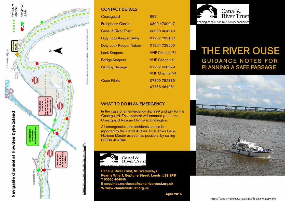
The main navigable channel between Boothferry Bridge
and Howdendyke Island changes position. The plan
overleaf indicates the navigable channel at this location.
Commercial vessels operate on the river including
shipping at Howdendyke, Drax and Selby. Skippers
should be aware and maintain a good lookout behind.
Debris is often present in the river and can foul and
damage propellers and steering gear.
The following notes are advisory and are intended to provide
guidance for vessels planning passage on the upper tidal
reaches of the River Ouse north of Goole. Further
information on planning passage can be found at https://
canalrivertrust.org.uk/north-east-waterways
MARINE BAND RADIOS
Although not mandatory, skippers are strongly advised to
carry marine band VHF radios and be suitably qualified in
their use when travelling on tidal sections of the River Ouse
(and other commercial waterways). Skippers are advised
that it is a mandatory requirement of adjoining port
authorities for marine band VHF radios to be used.
TIDE INFORMATION
Tides flood for 2 to 3 hours and ebb for up to 10 hours.
Tidal flows in the river are strong, typically 2–3 knots but up
to 9 knots on the flood tide at Selby. Tide times and
heights can be unpredictable.
At low water the lower reaches of the river are very
shallow and craft are at risk of grounding.