The role of legacy seismic in exploring new offshore hydrocarbon provinces – or can you “teach” old data new tricks (technologies)? Howard Nicholls, Lauren Penn, Anna Marszalek, Paolo Esestime, Karyna Rodriguez, Chris Benson and Milos Cvetkovic, Spectrum Geo Inc. Summary A number of case studies are examined for play concepts and leads using vintage seismic data that was processed with state-of-the-art pre-processing and imaging techniques. The Adriatic Sea was selected based upon the maturity of the Italian margin against the new exploration area of the Croatian margin. The Levantine basin, offshore Lebanon ranks as a region of new territory based on re-processing of vintage 2D data that led to optimized 3D data acquisition and superior imaging of the entire section. Re-processing examples from offshore Namibia are benefiting from improved pre-processing and geologically constrained velocity model building and imaging. Introduction In recent years there have been substantial improvements in a variety of seismic acquisition, processing and imaging technologies both from a research and practical standpoint. In such an ever-evolving environment, legacy data is often overlooked as inferior input data compared to newer recording systems and advanced survey programs. However, when retrieved and enhanced with modern re-processing techniques, it can be of significant value, particularly in frontier regions where no other data is available. Legacy seismic surveys are also key in prospect evaluation when acquired near the shore where new acquisition is no longer possible due to stricter environmental laws, in protected areas or in zones of political conflict. Moreover, geological information obtained from old surveys can be used to identify areas of interest and optimize acquisition parameters for new seismic surveys. Legacy seismic re-processing projects are usually triggered by renewed interest in open acreage or announcement of licensing rounds in unexplored regions. We will first go over some of the technologies that are “back-compatible” with older dataset and then show case studies from various regions. Figure 1 illustrates the benefits of reviewing different vintages of legacy data and its importance in frontier exploration. New tricks (or set of new technologies) Through the decades seismic imaging has improved due to a number of incremental and step changes in all parts of the
exploration workflow. Acquisition methods have progressed from 2D to 3D, covering larger areas. Furthermore, greater volumes of data being recorded result in improved signal-to-noise ratio. Compared to most legacy data newer datasets have longer offset giving greater fold data, which later subsequently aids velocity inversion, interpretation and multiple removal, and in subsalt regimes helps imaging by simple undershooting. The new technologies can be applied to old data (“back-compatible data”). This goes for plethora of re-processing algorithms such as various generations of de-multiple techniques, random and coherent noise suppressions (short time Fourier transform filters), providing for much better datasets both in 2D and in 3D. Depth domain model building with geological and other non-seismic model constraints yield Earth model properties with greater detail and resolution. As Gray (2013) points out we are moving into the age of larger bandwidth with the onset of broadband datasets and velocity inversion techniques that are inverting for high resolution models.
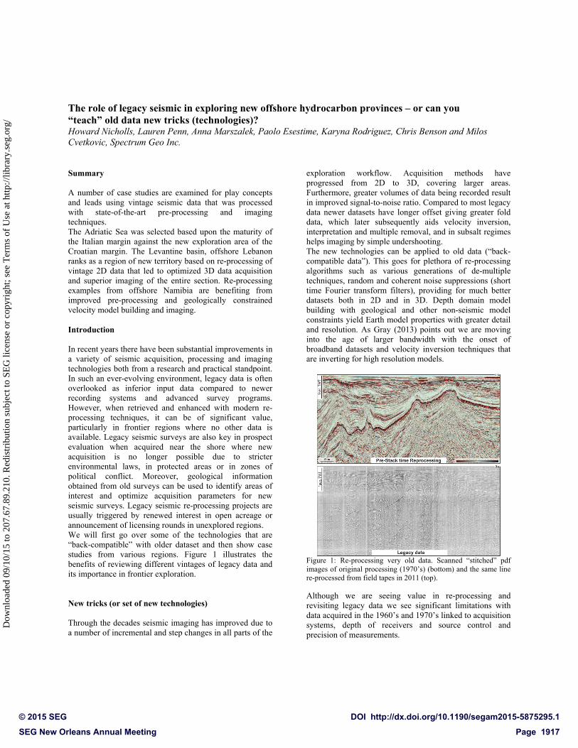
Figure 1: Re-processing very old data. Scanned “stitched” pdf images of original processing (1970’s) (bottom) and the same line re-processed from field tapes in 2011 (top). Although we are seeing value in re-processing and revisiting legacy data we see significant limitations with data acquired in the 1960’s and 1970’s linked to acquisition systems, depth of receivers and source control and precision of measurements.
The role of legacy seismic in exploring new offshore hydrocarbon provinces
From re-processing to new acquisition – Adriatic Sea A 2D marine dataset from the Italian side of Adriatic Sea has been re-processed from field tapes and evaluated along with respective stacks available only in hardcopy format (Figure 1). Data was acquired during the 1960’s and 1970’s and was shot with a short streamer (1600m or 2400m) and sparse shot point interval (50m or 134m), giving low fold. Signal to noise ratio is relatively high but its final image quality was restricted due to the limitations of the algorithms available at that time – usually a basic stack involving a simple trace by trace deconvolution for multiple attenuation with no migration, The data was re-processed using a modern PSTM sequence although the
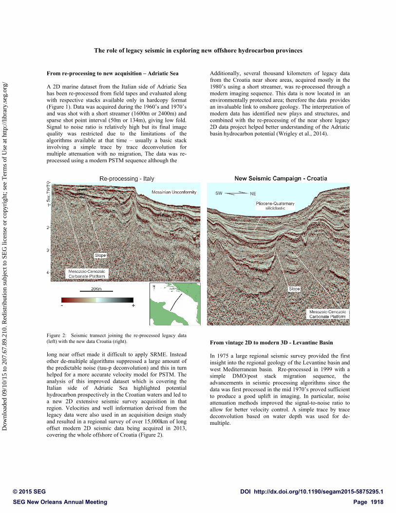
Figure 2: Seismic transect joining the re-processed legacy data (left) with the new data Croatia (right). long near offset made it difficult to apply SRME. Instead other de-multiple algorithms suppressed a large amount of the predictable noise (tau-p deconvolution) and this in turn helped for a more accurate velocity model for PSTM. The analysis of this improved dataset which is covering the Italian side of Adriatic Sea highlighted potential hydrocarbon prospectively in the Croatian waters and led to a new 2D extensive seismic survey acquisition in that region. Velocities and well information derived from the legacy data were also used in an acquisition design study and resulted in a regional survey of over 15,000km of long offset modern 2D seismic data being acquired in 2013, covering the whole offshore of Croatia (Figure 2).
Additionally, several thousand kilometers of legacy data from the Croatia near shore areas, acquired mostly in the 1980’s using a short streamer, was re-processed through a modern imaging sequence. This data is now located in an environmentally protected area; therefore the data provides an invaluable link to onshore geology. The interpretation of modern data has identified new plays and structures, and combined with the re-processing of the near shore legacy 2D data project helped better understanding of the Adriatic basin hydrocarbon potential (Wrigley et al., 2014).
From vintage 2D to modern 3D - Levantine Basin In 1975 a large regional seismic survey provided the first insight into the regional geology of the Levantine basin and west Mediterranean basin. Rre-processed in 1999 with a simple DMO/post stack migration sequence, the advancements in seismic processing algorithms since the data was first processed in the mid 1970’s proved sufficient to produce a good uplift in imaging. In particular, noise attenuation methods improved the signal-to-noise ratio to allow for better velocity control. A simple trace by trace deconvolution based on water depth was used for de-multiple.
The role of legacy seismic in exploring new offshore hydrocarbon provinces
After re-processing was complete, interpreters working with the new volume were able to identify key areas of interest in the Eastern Mediterranean region which then were targeted with a new seismic survey in 2000. Time and depth processing and re-processing of this dataset were instrumental in leading to the Tamar gas field discovery. The field was drilled in 2009, and discovered 460ft net of gas in Middle to Lower Miocene sands with the mean gas reserves of 8 TCF. Since then, there have been several subsequent significant discoveries within the Levantine Basin. The area for a new 3D survey was chosen after detailed interpretation of the re-processed data which allowed the complete imaging and mapping of the prospect-leads previously interpreted, opening to the evaluation of new potential discoveries. Figure 3 illustrates the improvement in seismic imaging from the original survey in 1975 to the 3D in 2013. The key horizons that eventually proved to be commercial discoveries are sparsely sampled and poorly imaged on the 1975 data. The 2000 acquisition gave hints of deeper targets, significantly enhanced by re-processing in 2007. However, it was not until the 3D was fully mapped and one can see the true structure and hence prospectivity at the Lower Miocene level (Hodgson, 2012).
Figure 3: Improving interpretation from re-processing legacy 2D data to 3D data. Offshore Lebanon original legacy section (top),
structure map based on 2D re-processed data (middle) and structure map based on modern 3D data (bottom). Geologically constrained model building as part of re-processing workflow for enhancing depth imaging – offshore Namibia The next example is from a newer dataset, five 2D lines (~1000km) acquired in 2012 and 2014 where the uplift is coming from a refined pre-processing sequence (additional demultiple steps where needed to remove residual multiple energy) and a revisited geologically constrained model building approach. Data is acquired with 10050m length streamer, 804 channels at 12.5m group interval; with 2ms sampling rate and 10s record length. The new piece of information here are recent deep water wells which have not delivered expected hydrocarbon success but are significantly helping de-risk play systems of this margin (Hodgson and Intawong 2013), and were used in guiding the model building. We incorporated geological constraints in terms of well velocities into the velocity model building workflow in early stages as a starting model for tomography. Wells that we have useful information for are of limited depth, and located on the continental shelf in shallow waters. The key horizons interpreted from the time migrated dataset for use in the initial model covered the water bottom, shallow clastic of the Late Cretaceous, and the break-up unconformity which separates post-rift and syn-rift sequences. Due to the limitations on well velocity control, a single constant velocity was assigned to each key horizon interpreted. Obviously, the level of uncertainty in the formations’ velocity increases with distance from the wells. In response to this, the velocity model update methodology was modified slightly, with one to two iterations of horizon tomography run first to provide a lateral update to the velocities and depths of each formation. Iterations of grid tomography follow, using automatically picked residual moveout for the shallower post and syn-rift sequences, and manually picked residual moveout for the deeper pre-rift sequence. The final velocity model again closely follows the main horizons, with grid tomography consistently resolving inversions in the post-rift sequence below the shallower clastic deposits. Comparing with a depth converted time migration, the geometry of the syn-rift structures are more geologically plausible. The improved imaging (Figure 4) also aided identification of source levels and potential hydrocarbon trapping geometries in the offshore region.
The role of legacy seismic in exploring new offshore hydrocarbon provinces
Figure 4: Models and data from different stages of imaging workflow, offshore Namibia. Interval velocity model derived from well info and interpretation, used as initial model (top left), after horizon based tomography update (middle left) and grid based tomography (bottom left); top right, middle right and bottom right are decimated Kirchhoff image gathers in respective order. Conclusions Applying modern processing techniques to data acquired decades ago can produce stark improvements quality and interpretability of the final section. This can lead to better regional mapping and enhance the understanding of the basins. Although legacy data may be limited with respect to bandwidth and usable offset range, modern processing technologies (e.g. de-ghosting) may still improve the final image quality. In areas now closed due to stricter environmental regulations, reprocessing provides the only method of obtaining improved images. Away from these restricted areas the reprocessed data permits planning new acquisition and understanding new areas for exploration. Acknowledgements We would like to thank Spectrum management for permission to publish this material. We would also like to thank Richard Clarke, Ramy Mahmoud and Tim Seher for reviewing and helping improve this abstract.
EDITED REFERENCES Note: This reference list is a copyedited version of the reference list submitted by the author. Reference lists for the 2015 SEG Technical Program Expanded Abstracts have been copyedited so that references provided with the online metadata for each paper will achieve a high degree of linking to cited sources that appear on the Web. REFERENCES
Gray, S. H., 2014, Seismic imaging and inversion: What are we doing, how are we doing, and where are we going?: 84th Annual International Meeting, SEG, Expanded Abstracts, 4416–4420.
Hodgson, N., 2012, The Miocene hydrocarbon play in Southern Lebanon: First Break, 30, no. 12, 93–98.
Hodgson, N., and A. Intawong, 2013, Derisking deep-water Namibia: First Break, 31, no. 12, 91–96.
Wrigley, R., A. Marszalek, K. Rodriguez, and N. Hodgson, 2014, Offshore Croatia- Hunting ‘Big Oil’ in the center of Europe: First Break, 32, no. 5, 75–82.