EFITA/WCCA 2005 25-28 July 2005, Vila Real, Portugal 2005 EFITA/WCCA JOINT CONGRESS ON IT IN AGRICULTURE The SIGIRA - Part I – Inventory of Small and Private Irrigation Schemes in Alentejo I. Oliveira – Centro Operativo e de tecnologia de Regadio – [email protected]M.S. Fabião – Centro Operativo e de tecnologia de Regadio – [email protected]J.L.Teixeira – Instituto Superior de Agronomia – [email protected]D.Carreira – [email protected]M.Silva – Centro Operativo e de tecnologia de Regadio – [email protected]1 - Introduction The main objective of this application will be, at this first phase, create a planning tool that allow to know the private small scale irrigated area, where are, the type of parcels involved, sources of water, irrigation methods and crops by parcels, and, if is needed, the irrigated area by each methods from each source of water. Simultaneous, from the knowledge of the availability of water, the crops installed and the irrigation method, it will be possible to know the type of irrigation we are dealing when it is compared the water needs with the availability by each irrigations schemes. This knowledge, will help the planners to replanning, among others things, the collective irrigation infra- structures to decrease the lack of water, for example, in an area larger than the parcel, where, for example, the farmers have irrigation structures, but, for any reason, they have not enough water for the total equipped area. 2 – Methodology 2.1 – Characterization of the zones covered by the inventory This inventory has being done in two of the three Administratives division of Alentejo, named “Distritos”: Central Alentejo (Évora’s Distrito) and Baixo Alentejo (Beja’s Distrito) and the Litoral Alentejano (Setúbal’s Distrito of Extremadura Region), covering 30 “Concelhos” (each “Distrito” is divided in “Concelhos” and each “Concelho” is divided in “Freguesias”) (Table 1 e Fig.1) Table 1 – Inventoried “Distritos” and “Concelhos” Distritos Évora Beja Setúbal Alandroal Aljustrel Alcácer do Sal Arraiolos Almodôvar Grândola Borba Alvito Santiago do Cacém Estremoz Beja Sines Évora Castro Verde Odemira Montemor-o-Novo Cuba Mourão Ferreira do Alentejo Portel Mértola Redondo Moura Reguengos de Monsaraz Serpa Vila Viçosa Ourique Viana do Alentejo Concelhos Vendas Novas Vidigueira 1309
Transcript
EFITA/WCCA 2005 25-28 July 2005, Vila Real, Portugal
2005 EFITA/WCCA JOINT CONGRESS ON IT IN AGRICULTURE
The SIGIRA - Part I – Inventory of Small and Private Irrigation Schemes in Alentejo
The main objective of this application will be, at this first phase, create a planning tool that allow to know the private small scale irrigated area, where are, the type of parcels involved, sources of water, irrigation methods and crops by parcels, and, if is needed, the irrigated area by each methods from each source of water.
Simultaneous, from the knowledge of the availability of water, the crops installed and the irrigation method, it will be possible to know the type of irrigation we are dealing when it is compared the water needs with the availability by each irrigations schemes.
This knowledge, will help the planners to replanning, among others things, the collective irrigation infra-structures to decrease the lack of water, for example, in an area larger than the parcel, where, for example, the farmers have irrigation structures, but, for any reason, they have not enough water for the total equipped area.
2 – Methodology
2.1 – Characterization of the zones covered by the inventory
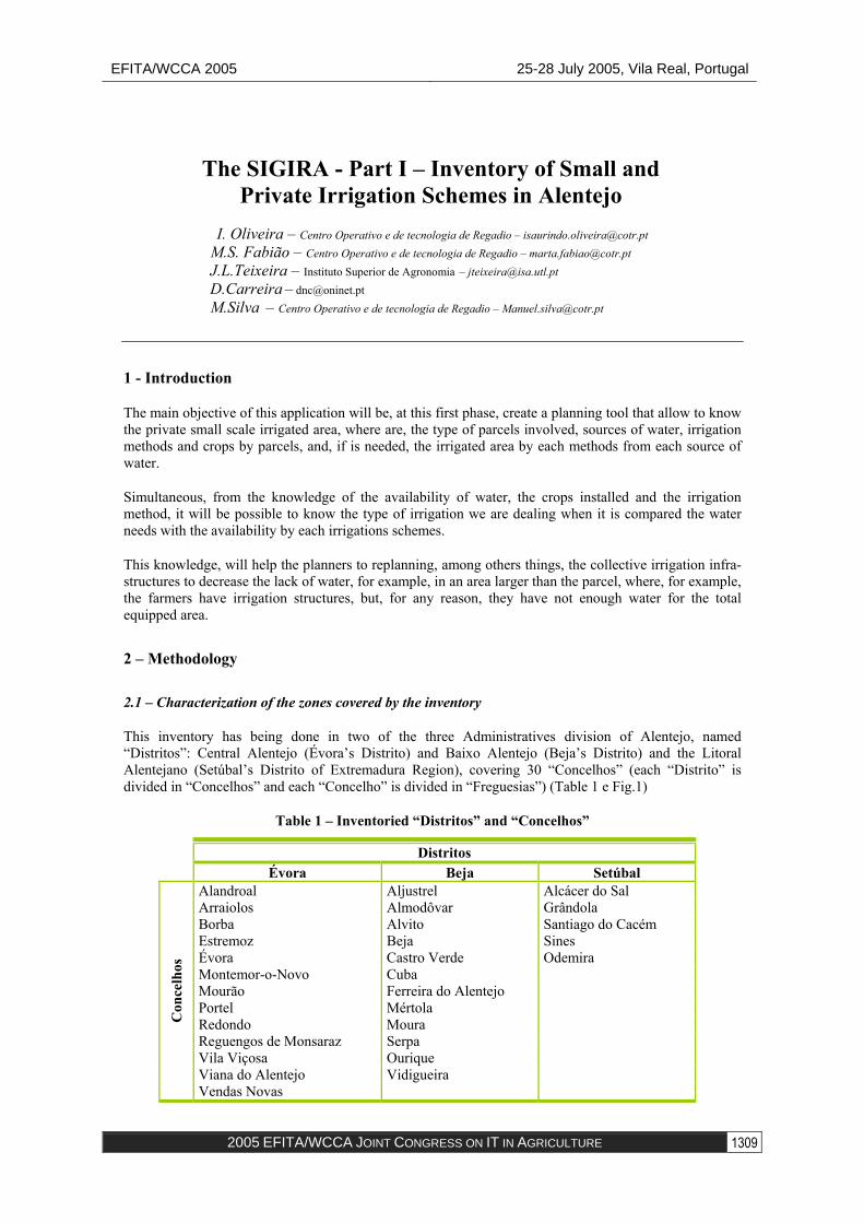
This inventory has being done in two of the three Administratives division of Alentejo, named “Distritos”: Central Alentejo (Évora’s Distrito) and Baixo Alentejo (Beja’s Distrito) and the Litoral Alentejano (Setúbal’s Distrito of Extremadura Region), covering 30 “Concelhos” (each “Distrito” is divided in “Concelhos” and each “Concelho” is divided in “Freguesias”) (Table 1 e Fig.1)
Table 1 – Inventoried “Distritos” and “Concelhos”
Distritos Évora Beja Setúbal
Alandroal Aljustrel Alcácer do Sal Arraiolos Almodôvar Grândola Borba Alvito Santiago do Cacém Estremoz Beja Sines Évora Castro Verde Odemira Montemor-o-Novo Cuba Mourão Ferreira do Alentejo Portel Mértola Redondo Moura Reguengos de Monsaraz Serpa Vila Viçosa Ourique Viana do Alentejo
Con
celh
os
Vendas Novas Vidigueira
1309
EFITA/WCCA 2005 25-28 July 2005, Vila Real, Portugal
2005 EFITA/WCCA JOINT CONGRESS ON IT IN AGRICULTURE
Fig. 1 – Small scale private (red) versus great and collective irrigation schemes in Alentejo (cian)
2.2 – Sources of information
The inventory of small scale private irrigation schemes in Alentejo – PRIA – Beja, Évora and Setúbal’s Distritos, was done based on available information reached in various Ministries and particular informations
The achieving of information has passed by differents phases:
1st phase – achieving of information about known existing irrigation schemes
At this first phase it was possible to identify, by differents sources of information, the existing irrigation schemes with an irrigated area larger than 5 ha.
The definition of the minimum area it was related with one of the main objective of this work where it was intended to build a new tool, in connection with this one, to help farmer in irrigation water management (see another paper presented to this congress named SIGIRA II).
Among the differents sources of information it is important mention:
- Instituto da Água – INAG – Ministry of Environment – informations about differents sources of surface water;
- Instituto Nacional de Garantia Agrícola – INGA – Ministry of Agriculture – information about the irrigated parcels;
- Direcção Regional de Agricultura do Alentejo – DRAAL - Ministry of Agriculture – information about all the irrigated schemes known in each “Concelho”;
- Comissão Vitivinícola do Alentejo - information about parcels dedicated to irrigated wine vineyards..
With the information known, it was created a database with information about each irrigated parcel (name of the owner, address, phone number, Distrito, Concelho, Freguesia, watershed, source of water, farm’s
1310
EFITA/WCCA 2005 25-28 July 2005, Vila Real, Portugal
2005 EFITA/WCCA JOINT CONGRESS ON IT IN AGRICULTURE
area, irrigated area, parcel’s number, irrigated area, irrigation method and crop by parcel, year of the implantation, etc).
At the end of this phase they were inventoried about 1500 spots, with 3924 parcels, belonging to approximately 804 owners, covering a total irrigated area of about 47100 ha.
2nd phase – After analysing the existing information, it begun the second phase where it was possible to complement the existing information, mainly the characteristics of the sources of water, namely available volume and/or discharge
This information was reached near the Divisão do Baixo Alentejo e Alentejo Litoral of the Comissão de Coordenação e Desenvolvimento Regional do Alentejo – CCDR – Alentejo.
3rd phase – acquisition of the irrigated parcels cartographic information
This information, in digital and georeferenced format, it was reached from INGA, after permission of each individual owner.
4st phase – acquisition of information related with soils.
This information, in digital and georeferenced format, as well as the database related, it was given by Instituto de Desenvolvimento Rural e Hidráulica – IDRHa - of Ministry of Agriculture .
With this cartographic information and the database related it was built the first phase of a GIS that allowed interconnect the information to make available an information essentially for planning and for water irrigation management.
3 – Characterization of irrigation farms by “Distritos” 3.1 – Irrigated parcels
At this stage, on the three areas where the inventory was developed, are already inventoried about 1500 irrigated spots, each one larger than 5 ha, corresponding to 3924 parcels, belonging to 804 owners. 1896 parcels are in the Beja’s Distrito (Baixo Alentejo), 1841 in the Évora’s Distrito (Alentejo Central) and 187 in Setúbal’s Distrito (Litoral Alentejano). Each parcel is georeferenced an has a numerical code.
These parcels (Fig.2) corresponds to 23566 ha in Beja’s Distrito, 22044 ha in the Évora’s Distrito and 1489 ha in Setúbal’s Distrito (Table 2)
Table 2 – Owners, Parcels and Areas related to the Small Scale Private Irrigations Schemes
To each parcel can be associated one or more irrigation methods, but, in general cases, it was found one parcel one method.
As it is difficult to know exactly parcel to parcel what is the area really occupied by the irrigation method, because, in many cases, the parcel configuration established by INGA is not completely adjusted to the area occupied by the irrigation method, it was considered that the area related to the irrigation method it was the parcel area.
In the cases where there are more than one irrigation method by each parcel, as is the case of one parcel irrigated by one pivot where the corners, instead to be free, are irrigated by a sprinkler solid-set, and
1311
EFITA/WCCA 2005 25-28 July 2005, Vila Real, Portugal
2005 EFITA/WCCA JOINT CONGRESS ON IT IN AGRICULTURE
whenever it is difficult to differentiate the areas related to the both, it was considered that all the parcel’ area would be irrigated only by the most representative irrigation method.
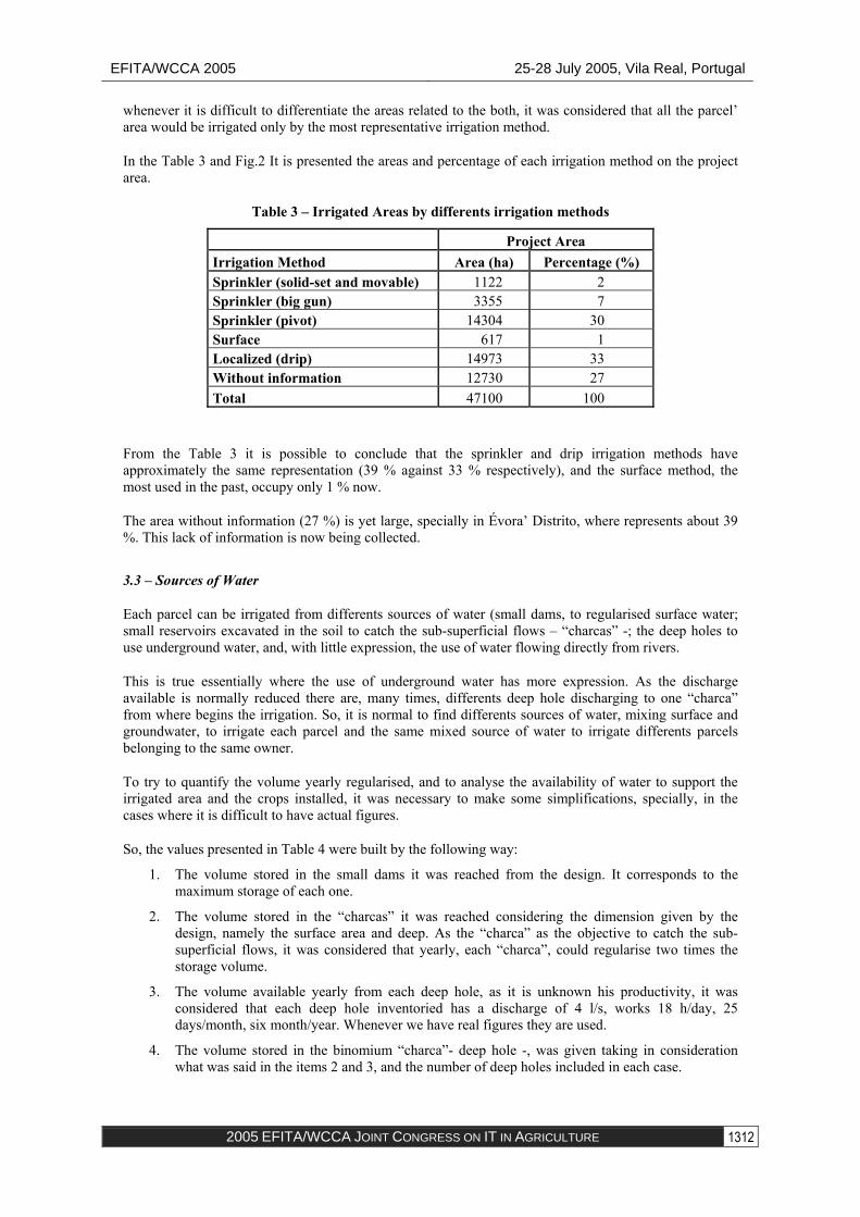
In the Table 3 and Fig.2 It is presented the areas and percentage of each irrigation method on the project area.
Table 3 – Irrigated Areas by differents irrigation methods
Project Area Irrigation Method Area (ha) Percentage (%) Sprinkler (solid-set and movable) 1122 2 Sprinkler (big gun) 3355 7 Sprinkler (pivot) 14304 30 Surface 617 1 Localized (drip) 14973 33 Without information 12730 27 Total 47100 100
From the Table 3 it is possible to conclude that the sprinkler and drip irrigation methods have approximately the same representation (39 % against 33 % respectively), and the surface method, the most used in the past, occupy only 1 % now.
The area without information (27 %) is yet large, specially in Évora’ Distrito, where represents about 39 %. This lack of information is now being collected.
3.3 – Sources of Water
Each parcel can be irrigated from differents sources of water (small dams, to regularised surface water; small reservoirs excavated in the soil to catch the sub-superficial flows – “charcas” -; the deep holes to use underground water, and, with little expression, the use of water flowing directly from rivers.
This is true essentially where the use of underground water has more expression. As the discharge available is normally reduced there are, many times, differents deep hole discharging to one “charca” from where begins the irrigation. So, it is normal to find differents sources of water, mixing surface and groundwater, to irrigate each parcel and the same mixed source of water to irrigate differents parcels belonging to the same owner.
To try to quantify the volume yearly regularised, and to analyse the availability of water to support the irrigated area and the crops installed, it was necessary to make some simplifications, specially, in the cases where it is difficult to have actual figures.
So, the values presented in Table 4 were built by the following way:
1. The volume stored in the small dams it was reached from the design. It corresponds to the maximum storage of each one.
2. The volume stored in the “charcas” it was reached considering the dimension given by the design, namely the surface area and deep. As the “charca” as the objective to catch the sub-superficial flows, it was considered that yearly, each “charca”, could regularise two times the storage volume.
3. The volume available yearly from each deep hole, as it is unknown his productivity, it was considered that each deep hole inventoried has a discharge of 4 l/s, works 18 h/day, 25 days/month, six month/year. Whenever we have real figures they are used.
4. The volume stored in the binomium “charca”- deep hole -, was given taking in consideration what was said in the items 2 and 3, and the number of deep holes included in each case.
1312
EFITA/WCCA 2005 25-28 July 2005, Vila Real, Portugal
2005 EFITA/WCCA JOINT CONGRESS ON IT IN AGRICULTURE
From the figures it is possible conclude that, although there is yet around 43,5 % of lack of information about the characteristics of sources of water inventoried, more than 50 % of the water used for irrigation of the small private irrigation schemes comes from surface of water regularised during winter time through small dams.
Table 4– Sources of water
Sources of Water Number without dataunites Regularized (m3) Nº Unites Nº Unites
The crops presented here (Table 5) respects to the year of 2003.
From the analyse of the figures it is possible to conclude that the most representative crop it was the maize occupying about 19 % of the area, following by wine vineyards with 14 % and olives with 16 %. These three crops occupied about 70 % of total area in 2003.
It is interesting to say that the irrigated winter cereals represented about 9 %. Here, the irrigation is essentially an irrigation of complement. The sugarbeet, occupying about 5 % were growing essentially in Beja’s Distrito.
The five crops occupied about 90 % of the total project area.
4 – Considerations about the software 4.1 – General Considerations
To treat, manage and consult the dates in the database was developed a specific informatics’ application that runs under ArcGIS 9.
This application was developed to allow:
1313
EFITA/WCCA 2005 25-28 July 2005, Vila Real, Portugal
2005 EFITA/WCCA JOINT CONGRESS ON IT IN AGRICULTURE
• Consults of data stored according to administratives criteria: “Freguesia”, “Concelho”, “Distrito”, Areas inside the watersheds upstream the big reservoirs belonging to the existing collective irrigations schemes and the areas that will be included in the futures irrigation schemes of Alqueva;
• Facilitate the consult by no specialized users to manage the relational database, preparing the design of predefined consults;
• Modify, erase and introduce the information
• Elaborate reports according the various criteria.
4.2 – Principles of utilisation
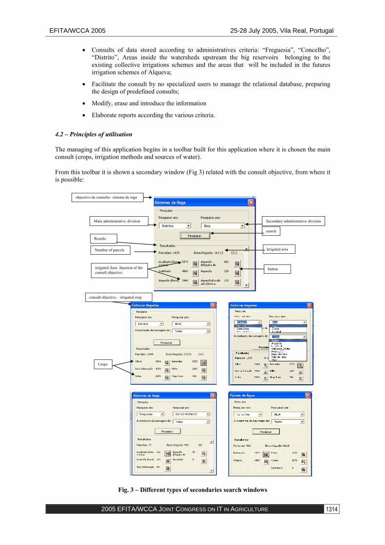
The managing of this application begins in a toolbar built for this application where it is chosen the main consult (crops, irrigation methods and sources of water).
From this toolbar it is shown a secondary window (Fig 3) related with the consult objective, from where it is possible:
Fig. 3 – Different types of secondaries search windows
Main administrative division Secondary administrative division
Results
search
objectivo da consulta– sistema de rega
Number of parcels Irrigated area
irrigated Área function of the consult objective
button
consult objective – irrigated crop
Crops
1314
EFITA/WCCA 2005 25-28 July 2005, Vila Real, Portugal
2005 EFITA/WCCA JOINT CONGRESS ON IT IN AGRICULTURE
To consult the parcels inventoried (areas and places):
• For all the project area by:
• “Freguesia”;
• “Concelho”;
• “Distrito”;
• Watershed of main rivers (Mira, Sado, Tejo e Guadiana);
• Watershed upstream the big dams of Mira, Alto Sado, Roxo, Odivelas, Pego do Altar, Vale de Gaio, Vigia, Minutos, Divor, Monte Novo, Pedrógão e Alqueva
• Futures irrigation schemes irrigated form Alqueva (irrigation schemes of Alqueva, Pedrogão and Ardila)
• Consult the localization of different types of sources of water (fontes de água) by any of the administratives zones with information about the volumes of water regularized yearly ;
• Consult the irrigated crops (culturas regadas) growing in 2003 (name, area and localization according with the administratives zones);
• Consult the irrigation methods (sistemas de rega) (name, area and localization according with the administratives zones);
• Verify the relationship between crops and irrigation methods
• Consult about the connexions:
• Parcels irrigated from one specific type of source of water (area and localization);
• Parcels occupied with one specific crop irrigated by one irrigation method (area and localization);
4.3 – Results of application 4.3.1 – General Presentation of Irrigation Schemes Inventoried
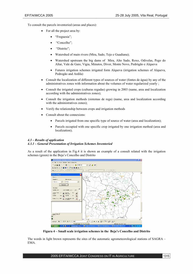
As a result of the application in Fig.4 it is shown an example of a consult related with the irrigation schemes (green) in the Beja’s Concelho and Distrito
Figura 4 – Small scale irrigation schemes in the Beja’s Concelho and Distrito
The words in light brown represents the sites of the automatic agrometeorological stations of SAGRA – EMA.
1315
EFITA/WCCA 2005 25-28 July 2005, Vila Real, Portugal
2005 EFITA/WCCA JOINT CONGRESS ON IT IN AGRICULTURE
For each type of search, it is shown the number of parcels and the corresponding area for the main and secondary administrative zone chosen, as well as the areas for each type search. In front of each type, there is a button that, when is pressed, show, in another colour, where are the parcels.
In Fig.5 it is an example to show the irrigated crops existing in the Beja,s Concelho. Here there are 275 parcels with an area of 1919 ha. In magenta it is shown the parcels with olives trees occupying an area of 395 ha.
Fig. 5 – Window showing the irrigated crops in Beja’s Concelho. Magenta colour represents the parcels growing olives
The same results can be seen for each of the differents options
5 – Conclusions
• A tool like this, supported in the small scale private and individual georeferenced inventory, is fundamental to help the decisions about irrigation water management
• There are yet some lack of information. However, they do not interfere in final conclusions, at this stage. The search of information is continuing.
• It is fundamental that, at the end, all of these information should be transferred to the Ministry of Agriculture, Ministry of Environment and the Reprentatives Farmers Organization to maintain the inventory actualized to support the other applications are being developed that runs based on the database created with the inventory.


![WCCA Summer Newsletter 2019[3] · speech from Sir Nicholas Kenyon, Managing Director of the Barbican Centre City of London Building of the Year Awards 2019 Judging of this year’s](https://static.documents.pub/doc/80x56/5f57213349599c33855d2d62/wcca-summer-newsletter-20193-speech-from-sir-nicholas-kenyon-managing-director.jpg)


