208
The South-west Marine Bioregional Plan Bioregional Profile A Description of the Ecosystems, Conservation Values and Uses of the South-west Marine Region

The South-west Marine Bioregional Plan
Bioregional Profile
A Description of the Ecosystems, Conservation Values and Uses of the South-west Marine Region

Short-headed seahorse. Photo: Michael Morris, Marine Life Society of South Australia.
Sourcing: Copies of this publication are available from:Community Information UnitAustralian GovernmentDepartment of the Environment, Water, Heritage and the ArtsEmail: [email protected]: 1800 803 772
Reproduction: Information contained in this publication may be reproduced in whole or in part for study or training purposes, subject to the inclusion of acknowledgement of the source and publisher, and provided no commercial usage or sale of the material occurs. Reproduction for purposes other than those given above requires written permission from the Department of the Environment, Water, Heritage and the Arts. Requests for permission should be addressed to: Public Affairs, Australian Government Department of the Environment, Water, Heritage and the Arts, John Gorton Building, GPO Box 787, Parkes, ACT, 2600.
Credits: Design and production by Imaginocean Productions.
Published by the Australian Government Department of the Environment, Water, Heritage and the Arts.
Printed on 100% recycled paper (cover 70% recycled).
State Library Ref:The South-west Marine Bioregional Plan: Bioregional Profile
ISBN: 9780642553652
Copyright: © Commonwealth of Australia 2007Reprinted 2008
This work is copyright. Apart from any use as permitted under the Copyright Act 1968, no part may be reproduced by any process without prior written permission from the Commonwealth, available from the Department of the Environment, Water, Heritage and the Arts. Requests and inquiries concerning reproduction and rights should be addressed to:Assistant SecretaryNational Oceans Office BranchDepartment of the Environment, Water, Heritage and the ArtsEdgar Waite Building203 Channel HighwayKingston TAS 7050

i
ContentsPreface . . . . . . . . . . . . . . . . . . . . . . . . . . . . . . . . . . . . . . . . . . . . . . . . . . . . . . . . . . . . . . . . . . . . . . . . . . . . . . . v
Executive Summary . . . . . . . . . . . . . . . . . . . . . . . . . . . . . . . . . . . . . . . . . . . . . . . . . . . . . . . . . . . . . . . . . . . . . 1
The Region’s environment and its conservation values . . . . . . . . . . . . . . . . . . . . . . . . . . . . . . . . . . . . . . . . . . . . . . . . . . 1
Conservation values of the South-west Marine Region . . . . . . . . . . . . . . . . . . . . . . . . . . . . . . . . . . . . . . . . . . . . . . . . . . 3
Marine protected areas in the South-west Marine Region . . . . . . . . . . . . . . . . . . . . . . . . . . . . . . . . . . . . . . . . . . . . . . . . 4
Human activities and the marine environment . . . . . . . . . . . . . . . . . . . . . . . . . . . . . . . . . . . . . . . . . . . . . . . . . . . . . . . 4
Next steps . . . . . . . . . . . . . . . . . . . . . . . . . . . . . . . . . . . . . . . . . . . . . . . . . . . . . . . . . . . . . . . . . . . . . . . . . . . . . . . . . 5
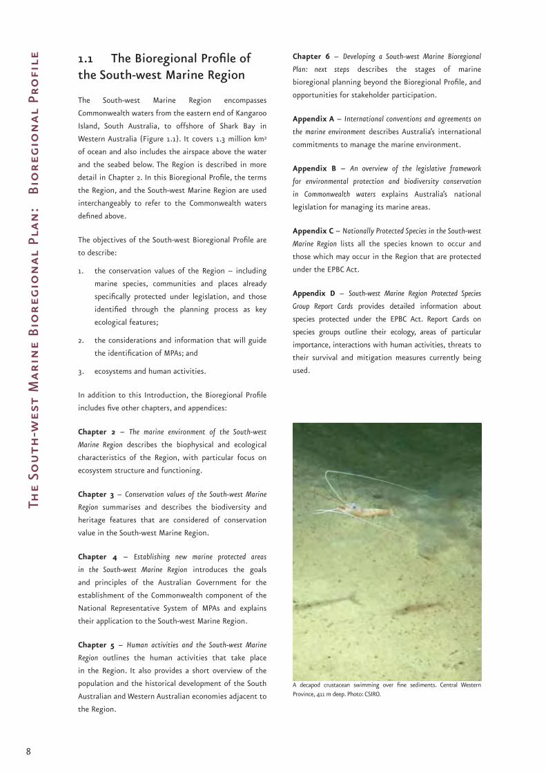
Chapter 1 Introduction . . . . . . . . . . . . . . . . . . . . . . . . . . . . . . . . . . . . . . . . . . . . . . . . . . . . . . . . . . . . . . . 7
1.1 The Bioregional Profile of the South-west Marine Region . . . . . . . . . . . . . . . . . . . . . . . . . . . . . . . . . . . . . . . . . . . . . 8
1.2 Supporting information . . . . . . . . . . . . . . . . . . . . . . . . . . . . . . . . . . . . . . . . . . . . . . . . . . . . . . . . . . . . . . . . . . . 9
Key references and further readings . . . . . . . . . . . . . . . . . . . . . . . . . . . . . . . . . . . . . . . . . . . . . . . . . . . . . . . . . . . . . . . . . 9
Chapter 2 The Marine Environment of the South-west Marine Region . . . . . . . . . . . . . . . . . . . . . . . . . . . .11
2.1 The bioregions of the South-west Marine Region . . . . . . . . . . . . . . . . . . . . . . . . . . . . . . . . . . . . . . . . . . . . . . . . . 16
2.1.1 Southwest Shelf Transition . . . . . . . . . . . . . . . . . . . . . . . . . . . . . . . . . . . . . . . . . . . . . . . . . . . . . . . . . . . . . . 17
2.1.2 Central Western Province . . . . . . . . . . . . . . . . . . . . . . . . . . . . . . . . . . . . . . . . . . . . . . . . . . . . . . . . . . . . . . . 22
2.1.3 Southwest Shelf Province . . . . . . . . . . . . . . . . . . . . . . . . . . . . . . . . . . . . . . . . . . . . . . . . . . . . . . . . . . . . . . . 26
2.1.4 Southwest Transition . . . . . . . . . . . . . . . . . . . . . . . . . . . . . . . . . . . . . . . . . . . . . . . . . . . . . . . . . . . . . . . . . . 30
2.1.5 Great Australian Bight Shelf Transition . . . . . . . . . . . . . . . . . . . . . . . . . . . . . . . . . . . . . . . . . . . . . . . . . . . . . . 32
2.1.6 Spencer Gulf Shelf Province . . . . . . . . . . . . . . . . . . . . . . . . . . . . . . . . . . . . . . . . . . . . . . . . . . . . . . . . . . . . . . 36
2.1.7 Southern Province . . . . . . . . . . . . . . . . . . . . . . . . . . . . . . . . . . . . . . . . . . . . . . . . . . . . . . . . . . . . . . . . . . . . 40
Key references and further readings . . . . . . . . . . . . . . . . . . . . . . . . . . . . . . . . . . . . . . . . . . . . . . . . . . . . . . . . . . . . . . . . 44
Chapter 3 Conservation Values of the South-west Marine Region . . . . . . . . . . . . . . . . . . . . . . . . . . . . . . . 47
3.1 Key ecological features of the marine environment . . . . . . . . . . . . . . . . . . . . . . . . . . . . . . . . . . . . . . . . . . . . . . . . 48
3.2 Nationally protected species . . . . . . . . . . . . . . . . . . . . . . . . . . . . . . . . . . . . . . . . . . . . . . . . . . . . . . . . . . . . . . . . 54
3.2.1 Protected species in the South-west Marine Region . . . . . . . . . . . . . . . . . . . . . . . . . . . . . . . . . . . . . . . . . . . . . 55
3.2.2 Flagship species of the South-west Marine Region . . . . . . . . . . . . . . . . . . . . . . . . . . . . . . . . . . . . . . . . . . . . . . 60
3.3 Protected Places . . . . . . . . . . . . . . . . . . . . . . . . . . . . . . . . . . . . . . . . . . . . . . . . . . . . . . . . . . . . . . . . . . . . . . . . 62
3.3.1 The Great Australian Bight Marine Park . . . . . . . . . . . . . . . . . . . . . . . . . . . . . . . . . . . . . . . . . . . . . . . . . . . . . . 62
3.3.2 Historic shipwrecks . . . . . . . . . . . . . . . . . . . . . . . . . . . . . . . . . . . . . . . . . . . . . . . . . . . . . . . . . . . . . . . . . . . 63
3.4 Consideration of pressures on regional conservation values . . . . . . . . . . . . . . . . . . . . . . . . . . . . . . . . . . . . . . . . . . 65
Key references and further readings . . . . . . . . . . . . . . . . . . . . . . . . . . . . . . . . . . . . . . . . . . . . . . . . . . . . . . . . . . . . . . . . 66
Chapter 4 Establishing New Marine Protected Areas in the South-west Marine Region . . . . . . . . . . . . . . 69
4.1 Goals and Principles . . . . . . . . . . . . . . . . . . . . . . . . . . . . . . . . . . . . . . . . . . . . . . . . . . . . . . . . . . . . . . . . . . . . . . 70
4.1.1 The goals . . . . . . . . . . . . . . . . . . . . . . . . . . . . . . . . . . . . . . . . . . . . . . . . . . . . . . . . . . . . . . . . . . . . . . . . . . 71
4.1.2 Guiding Principles . . . . . . . . . . . . . . . . . . . . . . . . . . . . . . . . . . . . . . . . . . . . . . . . . . . . . . . . . . . . . . . . . . . . 72
4.2 Regional specifications for identifying representative MPAs in the South-west Marine Region . . . . . . . . . . . . . . . . . . 74
4.2.1 Meeting the goals in the South-west . . . . . . . . . . . . . . . . . . . . . . . . . . . . . . . . . . . . . . . . . . . . . . . . . . . . . . . 74
4.2.2 Applying the principles in the South-west . . . . . . . . . . . . . . . . . . . . . . . . . . . . . . . . . . . . . . . . . . . . . . . . . . . . 78
4.3 Process for establishing new Commonwealth marine reserves in the South-west Marine Region . . . . . . . . . . . . . . . . . 80
Key references and further readings . . . . . . . . . . . . . . . . . . . . . . . . . . . . . . . . . . . . . . . . . . . . . . . . . . . . . . . . . . . . . . . . 81
Chapter 5 Human Activities and the South-west Marine Region . . . . . . . . . . . . . . . . . . . . . . . . . . . . . . . . 85
5.1 The human dimension: an overview . . . . . . . . . . . . . . . . . . . . . . . . . . . . . . . . . . . . . . . . . . . . . . . . . . . . . . . . . . 86
5.2 Marine activities . . . . . . . . . . . . . . . . . . . . . . . . . . . . . . . . . . . . . . . . . . . . . . . . . . . . . . . . . . . . . . . . . . . . . . . . 90
5.2.1 Commercial fishing . . . . . . . . . . . . . . . . . . . . . . . . . . . . . . . . . . . . . . . . . . . . . . . . . . . . . . . . . . . . . . . . . . . . 90
5.2.2 Defence activities . . . . . . . . . . . . . . . . . . . . . . . . . . . . . . . . . . . . . . . . . . . . . . . . . . . . . . . . . . . . . . . . . . . . . 95
5.2.3 Marine tourism . . . . . . . . . . . . . . . . . . . . . . . . . . . . . . . . . . . . . . . . . . . . . . . . . . . . . . . . . . . . . . . . . . . . . . 96
5.2.4 Offshore aquaculture . . . . . . . . . . . . . . . . . . . . . . . . . . . . . . . . . . . . . . . . . . . . . . . . . . . . . . . . . . . . . . . . . . 97
5.2.5 Offshore minerals . . . . . . . . . . . . . . . . . . . . . . . . . . . . . . . . . . . . . . . . . . . . . . . . . . . . . . . . . . . . . . . . . . . . 98

ii
5.2.6 Petroleum exploration and production . . . . . . . . . . . . . . . . . . . . . . . . . . . . . . . . . . . . . . . . . . . . . . . . . . . . . . 99
5.2.7 Recreational use . . . . . . . . . . . . . . . . . . . . . . . . . . . . . . . . . . . . . . . . . . . . . . . . . . . . . . . . . . . . . . . . . . . . . 101
5.2.8 Sea dumping . . . . . . . . . . . . . . . . . . . . . . . . . . . . . . . . . . . . . . . . . . . . . . . . . . . . . . . . . . . . . . . . . . . . . . . 102
5.2.9 Shipping and ports . . . . . . . . . . . . . . . . . . . . . . . . . . . . . . . . . . . . . . . . . . . . . . . . . . . . . . . . . . . . . . . . . . . 103
5.2.10 Submarine telecommunication cables . . . . . . . . . . . . . . . . . . . . . . . . . . . . . . . . . . . . . . . . . . . . . . . . . . . . . 104
Key references and further readings . . . . . . . . . . . . . . . . . . . . . . . . . . . . . . . . . . . . . . . . . . . . . . . . . . . . . . . . . . . . . . . 105
Chapter 6 Developing a South-west Marine Bioregional Plan: Next Steps . . . . . . . . . . . . . . . . . . . . . . . . 109
Appendix A International Conventions and Agreements on the Marine Environment . . . . . . . . . . . . . . . . .113
Appendix B An Overview of the Legislative Framework for Environmental Protection and Biodiversity Conservation in Commonwealth Waters . . . . . . . . . . . . . . . . . . . . . . . . . . . . . . . . . . . . . . . . . . 121
Appendix C Nationally Protected Species in the South-west Marine Region . . . . . . . . . . . . . . . . . . . . . . . .129
Appendix D South-west Marine Region Protected Species Group Report Cards . . . . . . . . . . . . . . . . . . . . . 149
Acronyms and Abbreviations . . . . . . . . . . . . . . . . . . . . . . . . . . . . . . . . . . . . . . . . . . . . . . . . . . . . . . . . . . . . .192
Glossary . . . . . . . . . . . . . . . . . . . . . . . . . . . . . . . . . . . . . . . . . . . . . . . . . . . . . . . . . . . . . . . . . . . . . . . . . . . . .193
Tables and BoxesTable 2.1 Key ecological features and other important areas of the Southwest Shelf Transition . . . . . . . . . . . . . . . . . . . . . . . . 21
Table 2.2 Key ecological features and other important areas of the Central Western Province . . . . . . . . . . . . . . . . . . . . . . . . . 25
Table 2.3 Key ecological features and other important areas of the Southwest Shelf Province . . . . . . . . . . . . . . . . . . . . . . . . . 29
Table 2.4 Key ecological features and other important areas of the Southwest Transition . . . . . . . . . . . . . . . . . . . . . . . . . . . . 31
Table 2.5 Key ecological features and other important areas of the Great Australian Bight Shelf Transition . . . . . . . . . . . . . . . . 35
Table 2.6 Key ecological features and other important areas of the Spencer Gulf Shelf Province . . . . . . . . . . . . . . . . . . . . . . . . 38
Table 2.7 Key ecological features and other important areas of the Southern Province . . . . . . . . . . . . . . . . . . . . . . . . . . . . . . 43
Table 3.1 Key ecological features of the South-west Marine Region . . . . . . . . . . . . . . . . . . . . . . . . . . . . . . . . . . . . . . . . . . . 50
Table 3.2 Number of protected species known to occur in the Region by broad taxonomic group (as at April 2007) . . . . . . . . . . 56
Table 3.3 Important breeding, feeding and resting areas for species listed as threatened or migratory under the EPBC Act . . . . . 57
Table 3.4 Seabird rookeries on islands and coastal areas adjacent to the South-west Marine Region . . . . . . . . . . . . . . . . . . . . . 59
Box 4.1 IUCN Categories assigned under the EPBC Act for Marine Protected Areas . . . . . . . . . . . . . . . . . . . . . . . . . . . . . . . . . . . 73
Table 4.1 Depth and area of each bioregion . . . . . . . . . . . . . . . . . . . . . . . . . . . . . . . . . . . . . . . . . . . . . . . . . . . . . . . . . . . . 75
Table 5.1 Population of major cities/towns adjacent to the South-west Marine Region (2001) . . . . . . . . . . . . . . . . . . . . . . . . 88
Table 5.2 Commonwealth and jointly-managed fisheries active within the Region (2004/05) . . . . . . . . . . . . . . . . . . . . . . . . . 91
Table 5.3 South Australian-managed fisheries active within the Region (2004/05) . . . . . . . . . . . . . . . . . . . . . . . . . . . . . . . . . 92
Table 5.4 Western Australian-managed fisheries active within the Region (2004/05) . . . . . . . . . . . . . . . . . . . . . . . . . . . . . . . 93
Box B1 The Commonwealth marine area . . . . . . . . . . . . . . . . . . . . . . . . . . . . . . . . . . . . . . . . . . . . . . . . . . . . . . . . . . . . 122
Table C1 Protected species known to occur in the South-west Marine Region . . . . . . . . . . . . . . . . . . . . . . . . . . . . . . . . . . . 130
Table C2 Protected species that may infrequently occur in the South-west Marine Region . . . . . . . . . . . . . . . . . . . . . . . . . . 143
Table D1 Sharks listed as threatened or migratory under the EPBC Act that are known to occur in the
South-west Marine Region . . . . . . . . . . . . . . . . . . . . . . . . . . . . . . . . . . . . . . . . . . . . . . . . . . . . . . . . . . . . . . . . 149
Table D2 Bony fish listed as threatened under the EPBC Act that are known to occur in the South-west Marine Region . . . . . . 155
Table D3 Marine turtles listed as threatened or migratory under the EPBC Act that are known to occur in the
South-west Marine Region . . . . . . . . . . . . . . . . . . . . . . . . . . . . . . . . . . . . . . . . . . . . . . . . . . . . . . . . . . . . . . . 161
Table D4.1 Seabirds listed as threatened or migratory under the EPBC Act that are known to occur in the Region . . . . . . . . . . . 169
Table D4.2 The proportion of Australian seabird nesting populations that breed in areas immediately adjacent to the Region . . 170
Table D5 Pinnipeds listed as threatened under the EPBC Act that are known to occur in the Region . . . . . . . . . . . . . . . . . . . 175
Table D6 Cetaceans listed as threatened or migratory under the EPBC Act that are known to occur in the
South-west Marine Region . . . . . . . . . . . . . . . . . . . . . . . . . . . . . . . . . . . . . . . . . . . . . . . . . . . . . . . . . . . . . . . . 184

iii
FiguresFigure 1.1 Australia’s Marine Regions . . . . . . . . . . . . . . . . . . . . . . . . . . . . . . . . . . . . . . . . . . . . . . . . . . . . . . . . . . . . . . . . . . 5
Figure 2.1 Australia’s maritime zones . . . . . . . . . . . . . . . . . . . . . . . . . . . . . . . . . . . . . . . . . . . . . . . . . . . . . . . . . . . . . . . . . 11
Figure 2.2 Major ocean currents in Australian waters . . . . . . . . . . . . . . . . . . . . . . . . . . . . . . . . . . . . . . . . . . . . . . . . . . . . . . 12
Figure 2.3 Schematic of major ocean currents flowing through the South-west Marine Region . . . . . . . . . . . . . . . . . . . . . . . . . 13
Figure 2.4 Ocean colour image showing the eddy structure of the Leeuwin Current off the west coast . . . . . . . . . . . . . . . . . . . 14
Figure 2.5 Bioregions of the South-west Marine Region (IMCRA v.4.0) . . . . . . . . . . . . . . . . . . . . . . . . . . . . . . . . . . . . . . . . . . 16
Figure 2.6 The Southwest Shelf Transition . . . . . . . . . . . . . . . . . . . . . . . . . . . . . . . . . . . . . . . . . . . . . . . . . . . . . . . . . . . . . 17
Figure 2.7 Bathymetry of the Houtman Abrolhos Islands . . . . . . . . . . . . . . . . . . . . . . . . . . . . . . . . . . . . . . . . . . . . . . . . . . . 18
Figure 2.8 Simplified diagram of productivity in the marine environment. . . . . . . . . . . . . . . . . . . . . . . . . . . . . . . . . . . . . . . . 19
Figure 2.9 Simplified diagram of the life cycle of the western rock lobster including its main predators and prey . . . . . . . . . . . . 20
Figure 2.10 The Central Western Province . . . . . . . . . . . . . . . . . . . . . . . . . . . . . . . . . . . . . . . . . . . . . . . . . . . . . . . . . . . . . . . 22
Figure 2.11 Bathymetry of the Perth Canyon . . . . . . . . . . . . . . . . . . . . . . . . . . . . . . . . . . . . . . . . . . . . . . . . . . . . . . . . . . . . 23
Figure 2.12 Simplified diagram of upwelling and aggregations of marine life in the Perth Canyon . . . . . . . . . . . . . . . . . . . . . . . . 24
Figure 2.13 The Southwest Shelf Province . . . . . . . . . . . . . . . . . . . . . . . . . . . . . . . . . . . . . . . . . . . . . . . . . . . . . . . . . . . . . . 26
Figure 2.14 Simplified diagram of the predators and prey of small pelagic fish . . . . . . . . . . . . . . . . . . . . . . . . . . . . . . . . . . . . . 28
Figure 2.15 The Southwest Transition. . . . . . . . . . . . . . . . . . . . . . . . . . . . . . . . . . . . . . . . . . . . . . . . . . . . . . . . . . . . . . . . . . 30
Figure 2.16 The Great Australian Bight Shelf Transition . . . . . . . . . . . . . . . . . . . . . . . . . . . . . . . . . . . . . . . . . . . . . . . . . . . . . 32
Figure 2.17 Simplified diagram of the predators and prey of the Australian sea lion . . . . . . . . . . . . . . . . . . . . . . . . . . . . . . . . . . 34
Figure 2.18 Spencer Gulf Shelf Province . . . . . . . . . . . . . . . . . . . . . . . . . . . . . . . . . . . . . . . . . . . . . . . . . . . . . . . . . . . . . . . . 36
Figure 2.19 Bathymetry of Spencer Gulf and Gulf St Vincent showing outflow of Bonaparte’s Tongue . . . . . . . . . . . . . . . . . . . . . . 37
Figure 2.20 The Southern Province . . . . . . . . . . . . . . . . . . . . . . . . . . . . . . . . . . . . . . . . . . . . . . . . . . . . . . . . . . . . . . . . . . . 40
Figure 2.21 Bathymetry of the Albany Canyons . . . . . . . . . . . . . . . . . . . . . . . . . . . . . . . . . . . . . . . . . . . . . . . . . . . . . . . . . . . 41
Figure 2.22 Bathymetry of the Diamantina Fracture Zone . . . . . . . . . . . . . . . . . . . . . . . . . . . . . . . . . . . . . . . . . . . . . . . . . . . 41
Figure 3.1 Key ecological features of the South-west Marine Region . . . . . . . . . . . . . . . . . . . . . . . . . . . . . . . . . . . . . . . . . . . 49
Figure 3.2 The Great Australian Bight Marine Park . . . . . . . . . . . . . . . . . . . . . . . . . . . . . . . . . . . . . . . . . . . . . . . . . . . . . . . . 62
Figure 3.3 Historic shipwrecks with known locations in the South-west Marine Region . . . . . . . . . . . . . . . . . . . . . . . . . . . . . . 64
Figure 4.1 Bioregions of the South-west Marine Region . . . . . . . . . . . . . . . . . . . . . . . . . . . . . . . . . . . . . . . . . . . . . . . . . . . . 74
Figure 4.2 Depth ranges in the South-west Marine Region . . . . . . . . . . . . . . . . . . . . . . . . . . . . . . . . . . . . . . . . . . . . . . . . . . 75
Figure 4.3 Geomorphic features (seafloor features) of the South-west Marine Region . . . . . . . . . . . . . . . . . . . . . . . . . . . . . . . . 77
Figure 4.4 Whale aggregation areas and Australian sea lion breeding sites in the South-west Marine Region . . . . . . . . . . . . . . . 78
Figure 4.5 Native title claims in the Region . . . . . . . . . . . . . . . . . . . . . . . . . . . . . . . . . . . . . . . . . . . . . . . . . . . . . . . . . . . . 79
Figure 5.1 Distribution of Aboriginal coastal language groups in the south-west . . . . . . . . . . . . . . . . . . . . . . . . . . . . . . . . . . . 86
Figure 5.2 Average annual population growth adjacent to the South-west Marine Region (2001 – 2006) . . . . . . . . . . . . . . . . . . 89
Figure 5.3 Labour force structure by settlement type (2001) . . . . . . . . . . . . . . . . . . . . . . . . . . . . . . . . . . . . . . . . . . . . . . . . . 89
Figure 5.4 South-west Marine Region all fisheries combined catch (2000-02) . . . . . . . . . . . . . . . . . . . . . . . . . . . . . . . . . . . . . 90
Figure 5.5 Defence training areas within and adjacent to the Region . . . . . . . . . . . . . . . . . . . . . . . . . . . . . . . . . . . . . . . . . . . 95
Figure 5.6 Aquaculture production sites within and adjacent to the Region . . . . . . . . . . . . . . . . . . . . . . . . . . . . . . . . . . . . . . 97
Figure 5.7 Petroleum activities in the Region . . . . . . . . . . . . . . . . . . . . . . . . . . . . . . . . . . . . . . . . . . . . . . . . . . . . . . . . . . . 99
Figure 5.8 Distribution of recreational fishing effort (2001) . . . . . . . . . . . . . . . . . . . . . . . . . . . . . . . . . . . . . . . . . . . . . . . . 101
Figure 5.9 Sea dumping in the South-west Marine Region prior to the Environment Protection (Sea Dumping) Act 1981 . . . . . . 102
Figure 5.10 Shipping routes within the Region . . . . . . . . . . . . . . . . . . . . . . . . . . . . . . . . . . . . . . . . . . . . . . . . . . . . . . . . . . 103
Figure 5.11 Location of the SEA_ME_WE3 submarine cable . . . . . . . . . . . . . . . . . . . . . . . . . . . . . . . . . . . . . . . . . . . . . . . . . 104
Figure 6.1 Stages of marine bioregional planning in the South-west . . . . . . . . . . . . . . . . . . . . . . . . . . . . . . . . . . . . . . . . . . .111
Figure D1.1 Pinniped colonies identified as important feeding grounds for white sharks . . . . . . . . . . . . . . . . . . . . . . . . . . . . . 152
Figure D5.1 Australian sea lion breeding sites in the South-west Marine Region (South Australia) . . . . . . . . . . . . . . . . . . . . . . . 176
Figure D5.2 Australian sea lion breeding sites in the South-west Marine Region (Western Australia) . . . . . . . . . . . . . . . . . . . . . .177
Figure D6.1 Important areas for southern right, humpback and blue whales in the South-west Marine Region . . . . . . . . . . . . . . 186

Australian sea lion. Photo: David Muirhead, Marine Life Society of South Australia.

v
Preface
Marine bioregional planning is the Australian
Government’s world-leading approach to protecting
Australia’s marine environment. Marine bioregional
planning is underpinned by the principles of ecologically
sustainable development and contributes to an
ecosystem approach to the management of Australia’s
marine biodiversity and environment.
This Bioregional Profile has been prepared by the
Department of the Environment, Water, Heritage
and the Arts as the first step in the development of a
Marine Bioregional Plan for Australia’s South-west
Marine Region. It establishes the information-base upon
which the South-west Marine Bioregional Plan will be
developed. In particular, it focuses on the natural assets
of the South-west Marine Region, describes its ecological
characteristics, outlines its conservation values and
explains how new marine protected areas will be
identified. Additionally, it provides a broad description
of the human activities that take place in the Region.
The Bioregional Profile complements information
available on the Department’s website
<www.environment.gov.au>. The South-west Marine
Atlas for example, available at <www.environment.gov.au/
coasts/mbp/south-west>, is an interactive mapping tool
that displays information about the biodiversity and
physical characteristics of the Region and the human
activities they support. Our information-base will be
periodically updated as new information becomes
available.
The Bioregional Profile summarises information detailed
in a number of reports produced for marine bioregional
planning in this Region. These are available on the
internet at <www.environment.gov.au/coasts/mbp/
south-west> and include:
The South-west Marine Region: Ecosystems and Key Species
Groups – a literature review prepared in 2006 by a
consortium of scientists led by the South Australian
Research and Development Institute and the University
of Western Australia.
Characterisation of the Marine Environment of the South-west
Marine Region – reports the discussions and outcomes of
a two-day science workshop convened in Perth, Western
Australia, on 27-28 September 2006.
Geomorphology and Sedimentology of the South Western
Planning Area of Australia – prepared by Geoscience
Australia in 2005 (with a supplement in 2006) to
summarise all available information on the geology and
sedimentology of the Region.
A Socio-economic Analysis and Description of the Marine
Industries of Australia’s South-west Marine Region –
conducted by the Institute for Regional Development,
University of Western Australia.
Sea Countries of the South: Indigenous Interests and
Connections within the South-west Marine Region of Australia
– prepared by the Australian Institute of Aboriginal and
Torres Strait Islander Studies. This report is available at
<www.environment.gov.au/indigenous>.
While this Bioregional Profile and the associated
reports attempt to provide a comprehensive picture of
the Marine Region, and care has been taken to ensure
accuracy (for example, all reports were subject to a peer
review process), there may be gaps in information that
can be filled during the next stages of the planning
process. The Department of the Environment, Water,
Heritage and the Arts welcomes any contribution from
the public about information and data that may be
relevant to developing a bioregional plan for the South-
west Marine Region.
Please email any additional information, as well as any
questions or comments you might have concerning this
document, to:
Or mail to:
The Director
Marine Bioregional Planning - South
National Oceans Office Branch
Department of the Environment, Water, Heritage and
the Arts
Edgar Waite Building
203 Channel Highway
Kingston Tasmania 7050

A school of small fish swim around a basket star with arms extended to feed. Central Western Province, 174 m deep. Photo: CSIRO.
1
Executive Summary
Executive Summary
The Bioregional Profile is the first step in the
development of a Marine Bioregional Plan for Australia’s
South-west Marine Region. Marine Bioregional Plans will
provide strategic guidance for Government decision-
makers and marine users by:
describing each Region’s conservation values,
including mapping sites of importance for protected
species and communities, and ecological processes;
identifying regional priorities for action, based on
an assessment of threats to conservation values
and long-term policy goals; and
developing strategic guidance for proponents
and decision-makers. For example, by providing
a regional context for national guidelines to help
proponents within a region to consider whether
their action might result in a significant impact on
matters of national environmental significance.
Marine bioregional planning is also the process through
which the Australian Government identifies areas
within Commonwealth waters for inclusion in the
National Representative System of Marine Protected
Areas (MPAs). The guidelines the Government is using
to develop the National Representative System of MPAs
have been agreed with the States and the Northern
Territory. See <www.environment.gov.au/coasts/mpa>.
The Bioregional Profile describes the environmental
and socio-economic characteristics of the South-west
Marine Region. The Region comprises Commonwealth
waters from the eastern end of Kangaroo Island, South
Australia, to waters off Shark Bay, Western Australia (see
Figure 1.1). It covers some 1.3 million km2 and includes
both subtropical and temperate waters. Australia’s
deepest areas of ocean, reaching depths of approximately
5900 m, are found in the Region, in the Diamantina
Fracture Zone south of Cape Leeuwin.
A Glossary has been developed to assist with
technical terminology used in the Bioregional
Profile. The glossary is located on page 193.
Separate large-format maps of the geomorphic
and key ecological features of the Region can
be found in the envelope inside the back cover.
•
•
•
The Region’s environment and its
conservation values
By global standards, the South-west Marine Region has
high biodiversity and is home to many species that
occur nowhere else (endemic species). The biological
productivity of the Region is relatively low, compared to
other marine regions of the world, mainly because of the
interactions of the Leeuwin Current with other currents,
which result in the absence of large seasonal upwellings
of nutrient-rich water from the deeper parts of the
Region. There are, however, small seasonal upwellings
that are ecologically important because they enhance
biological productivity in specific areas of the Region.
The Integrated Marine and Coastal Regionalisation of Australia
Version 4.0 divides the South-west Marine Region into
seven bioregions1:
The Southwest Shelf Transition
(Area: 32 809 km2; max depth: 200 m)
This bioregion covers the continental shelf extending
seaward from Kalbarri to Perth. Its ecology is heavily
influenced by the Leeuwin Current, which carries sub-
tropical and tropical species southward. Here they mix
with temperate species to form diverse and unique
biological communities, such as those surrounding the
Houtman Abrolhos Islands. Adjoining one of the most
populated coastal areas of the south-west, this bioregion
is critical to a number of industries and other activities,
including fishing (particularly for western rock lobster),
defence and, more recently, petroleum production.
The Central Western Province
(Area: 268 460 km2; max depth: 5795 m)
This offshore bioregion extends from the Southwest
Shelf Transition to the limit of the Australian Exclusive
Economic Zone (EEZ). The continental slope is cut by
numerous canyons, including the Perth Canyon, the
largest of Australia’s submarine canyons. The bioregion
is characterised by numerous eddies (circulating bodies
of water, about 200-300 kilometres in diameter) that
detach from the Leeuwin Current, trapping shallow
water biological communities and nutrients and
transporting them offshore. The Perth Canyon appears
to be an important ecological feature attracting krill and
1 For the purpose of this document, ‘bioregion’ means provincial bioregion as defined in the Integrated Marine and Coastal Regionalisation of Australia Version 4.0.

2
fish aggregations that in turn attract larger species such
as predatory fish and pygmy blue whales. This bioregion
is of high value for recreational and commercial fishers
and is important for shipping and defence training.
The Southwest Shelf Province
(Area: 73 772 km2; max depth: 200 m)
This bioregion extends over a long stretch of continental
shelf from Fremantle in the north around to Point
Dempster, east of Esperance, in the south. Marine life
in the bioregion is very diverse and clearly influenced
by the warm waters of the Leeuwin Current. It includes
globally important biodiversity hotspots, such as the
waters off Geographe Bay and those surrounding the
Recherche Archipelago. This bioregion is important
to the petroleum industry, shipping, marine tourism,
and charter, recreational and commercial fishing.
The Southwest Transition
(Area: 101 055 km2; max depth: 5190 m)
This is one of the South-west Marine Region’s least
researched bioregions. It is dominated by the Naturaliste
Plateau, a large extension of the continental plate,
which adjoins the continental slope through the
Naturaliste Trough. Little biological sampling has been
conducted here due to its remoteness and rough waters,
but based on its characteristics and data from elsewhere
in the world, scientists believe that the Plateau hosts
rich and diverse biological communities. Recently, a
number of exploratory surveys of the seafloor have
been undertaken to test the petroleum prospectivity.
The Great Australian Bight Shelf Transition
(Area: 146 547 km2; max depth: 200 m)
This is a vast and shallow bioregion. It includes the only
existing Commonwealth marine reserve in the south-
west, the Great Australian Bight Marine Park, which
was established in 1998 and is jointly-managed by the
Australian and South Australian Governments. The
Benthic Protection Zone of the Great Australian Bight
Marine Park projects offshore into the neighbouring
Southern Province. The Great Australian Bight Shelf
Transition extends from Point Dempster to Ceduna.
The invertebrate communities that inhabit the seafloor
are among the most diverse in the world. The inshore
areas of the bioregion are globally important for the
threatened southern right whale and the Australian sea
lion. The coast adjacent to this bioregion is the least
populated in the south-west. A range of commercial
fisheries are active within this bioregion including
the Southern Bluefin Tuna Fishery and other State and
Australian Government-managed fisheries.
The Spencer Gulf Shelf Province
(Area: 133 160 km2; max depth: 200 m)
This bioregion straddles Australia’s South-west and
South-east Marine Regions, extending east from Ceduna.
Seasonal winds and ocean currents interact with
seafloor features to produce a number of small seasonal
upwellings that are important for biological productivity.
This enhanced productivity appears to support the
commercial and recreational fisheries of the bioregion.
Commercial fishers are active in the bioregion, targeting
species including sardines and other scalefish. Charter
and recreational fishers also fish in this bioregion. The
adjacent coastline is complex with shallow gulfs and
numerous islands. The bioregion is noted for its very
diverse seafloor communities, productivity hotspots
and aggregations of marine life associated with small
seasonal upwellings. New Zealand fur seals, Australian
sea lions, dolphins, penguins, blue whales and seabirds
inhabit or visit the area.
The Southern Province
(Area: 770 270 km2; max depth: 5900 m)
This bioregion covers almost half the Region and
extends offshore from the south-west corner of the
Australian mainland across to the eastern boundary
of the South-west Marine Region. Submarine canyons
and the Diamantina Fracture Zone are key ecological
features of the Southern Province. Some of these
canyons are important aggregation areas for a range of
species, including commercially fished species, deep-
diving toothed whales, dolphins and New Zealand fur
seals. There are a number of prospective areas for oil and
gas in the bioregion.

3
Executive Summary
Conservation values of the South-west
Marine Region
Conservation values1 of the South-west Marine Region
include protected species and protected places, as
well as a number of key ecological features in the
Commonwealth marine environment identified as part
of this planning process.
A total of 105 species that are known to live in the
Region are protected under the Environment Protection
and Biodiversity Conservation Act 1999 (EPBC Act), either as
threatened, migratory, listed marine or cetacean species.
Of these, 26 species are listed as threatened, including
five endangered species, 20 vulnerable and one listed as
conservation dependent.
This Bioregional Profile identifies a number of ecological
features that are of conservation value because of the
role they play in the marine environment of the Region.
They are given this value on the following basis:
a species, group of species or a community with a
regionally important ecological role;
a species, group of species or a community that is
nationally or regionally important for biodiversity;
an area or habitat that is nationally or regionally
important for:
a) enhanced or high productivity;
b) aggregations of marine life;
c) biodiversity and endemism; or
a unique seafloor feature with known or presumed
ecological properties of regional significance.
1 Marine conservation values are defined for the purpose of marine bioregional planning, as including:
Key ecological features of the marine environment, including: (i) species and communities considered to play an important ecological role in the Region and (ii) habitats or areas considered to be ecologically important at a regional scale.
Protected species and communities, including: (i) species and communities listed as threatened under the EPBC Act; (ii) species listed as migratory under the EPBC Act; (iii) species listed as cetaceans (including all whales, dolphins and porpoises) under the EPBC Act; and (iv) species listed as marine species under the EPBC Act.
Protected places, including: (i) heritage places (including World Heritage, National Heritage and Commonwealth Heritage); (ii) historic shipwrecks; (iii) Commonwealth marine reserves; and (iv) listed critical habitats.
•
•
•
•
Key ecological features of the South-west Marine Region
that have conservation value are:
the West Coast Canyons and adjacent shelf break
(enhanced productivity; feeding aggregations;
unique seafloor feature);
the Diamantina Fracture Zone (unique seafloor
feature);
the Albany Canyons Group and adjacent shelf break
(enhanced productivity; feeding aggregations;
unique seafloor feature);
the Kangaroo Island canyons and the adjacent shelf
break (enhanced productivity; feeding and breeding
aggregations; unique seafloor feature);
the ‘Kangaroo Island Pool’ and Eyre Peninsula
upwellings (enhanced productivity; feeding
aggregations);
meso-scale (hundreds of kilometre) eddies in
predictable locations – south-west of Shark Bay,
offshore of the Houtman Abrolhos Islands, south-
west of Jurien Bay, south-west of Cape Naturaliste
and Cape Leeuwin and south of Albany, Esperance
and the Eyre Peninsula (enhanced productivity;
feeding aggregations);
the Naturaliste Plateau (unique seafloor feature);
Commonwealth waters within and adjacent to the
west coast inshore lagoons – extending from south
of Mandurah to Kalbarri (enhanced productivity
(benthic); breeding and nursery aggregations);
Commonwealth waters surrounding the Houtman
Abrolhos Islands (high biodiversity);
Commonwealth waters within and adjacent to
Geographe Bay (enhanced productivity (benthic);
high biodiversity; feeding, resting, breeding and
nursery aggregations);
Commonwealth waters surrounding the Recherche
Archipelago (high biodiversity; breeding and resting
aggregations);
the Cape Mentelle upwelling (enhanced pelagic
productivity; feeding aggregations);
•
•
•
•
•
•
•
•
•
•
•
•

4
Commonwealth waters adjacent to the Head of
Bight (enhanced productivity (pelagic); high
biodiversity; feeding and resting aggregations);
western rock lobster (species with an important
ecological role);
small pelagic fish (species group with important
ecological role);
demersal slope fish communities of the Central
Western Province (communities with high species
diversity); and
benthic invertebrate communities of the eastern
Great Australian Bight (communities with high
species diversity).
A description of these key ecological features of regional
conservation value is given in Chapter 3.
There are no listed heritage sites in the South-west
Marine Region. However, there are five known historic
shipwrecks found within the Region that are considered
of regional conservation value (most historic shipwrecks
are found within State waters). These are the:
SS Cambewarra, a steam powered transport vessel
wrecked in 1914 near Fisherman’s Island, 80 km
south of Dongara, Western Australia;
Red Rover, a fishing boat wrecked in 1887 near Coffin
Bay, South Australia;
Lord Roberts, wrecked in 1902 in the Gulf St Vincent
region, South Australia;
HMAS Sydney II, wrecked in 1941 while engaged
in battle with the HSK Kormoran, approximately
250 km off the mid-west coast of Western Australia;
and
HSK Kormoran, wrecked in 1941 while engaged
in battle with the HMAS Sydney II, approximately
250 km off the mid-west coast of Western Australia.
These are protected under the Historic Shipwrecks Act
1976, which safeguards shipwrecks and associated relics
from damage, interference, removal or destruction.
Marine protected areas in the South-
west Marine Region
One of the largest marine reserves in Australia, the Great
Australian Bight Marine Park, is already established in
the South-west Marine Region. This park is comprised of
•
•
•
•
•
•
•
•
•
•
adjoining Australian and South Australian Government
protected areas, with both governments managing
the Park cooperatively. The Commonwealth waters
component of the Park was the first to include an
area especially designed to be ‘representative’ – that
is, to have as its main objective the protection of
examples of the type of ecosystems that occur within
the bioregion. When the South-west Marine Bioregional
Plan is complete, this Marine Park will be complemented
by new marine reserves to form a regional network of
marine protected areas (MPAs) as part of the developing
National Representative System of MPAs.
The new MPAs will be established to meet national
guidelines under which all Australian governments
are developing a comprehensive, adequate and
representative reserve system. The Australian
Government’s goals for establishing the MPA network are
described in Chapter 4 of this Bioregional Profile, along
with their application to the South-west Marine Region
and an outline of the principles that will guide the
location, selection, design and zoning of representative
MPAs. Consideration of the socio-economic implications
of potential MPAs will inform the Government’s decision
about a final regional MPA network.
Human activities and the marine
environment
The marine environment has played a central role for
coastal communities since before European settlement.
Aboriginal people have lived adjacent to the Region
for many thousands of years. Following European
settlement, the Region became an important area for
the then thriving sealing and whaling industries. The
last whaling station in Australia, near Albany, was active
up to 1978.
Today the major marine industries associated with
the Region include commercial fishing, marine-
based tourism, shipping, petroleum exploration and
production, defence activities and aquaculture. Twenty
ports adjacent to the Region provide vital services to the
Western Australian and South Australian communities.
Petroleum production in the Region commenced in
2006 and exploration continues in the Perth Basin, the
Mentelle Basin and the Bight Basin.
Australian Government-managed fisheries in the Region
target southern bluefin tuna, yellowfin and bigeye tuna,
blue-eye trevalla, ling, shark and other species. There are
also commercially important State-managed fisheries

5
Executive Summary
predominantly adjacent to the Region including the
Western Australian rock lobster and South Australian
southern rock lobster fisheries, and abalone, scallop,
shark, King George whiting and prawn fisheries. The
Region is also important for the recreational and charter
fishing it supports.
Next steps
This Bioregional Profile and associated web-based
information will guide development of a Draft Marine
Bioregional Plan for the South-west Marine Region.
The Draft Plan will be released for a period of formal
public comment, as required under the EPBC Act.
Conservation measures and potential implications for
people and industries will be considered and resolved
through a process involving stakeholder and wider
public consultation. A final Marine Bioregional Plan
will then be developed for consideration and approval
by the Minister for the Environment, Heritage and the
Arts. Once finalised, the Minister for the Environment,
Heritage and the Arts will be guided by the Marine
Bioregional Plan in all decisions made under the EPBC
Act for which the Plan has relevance.
Although marine bioregional planning is an
Australian Government programme undertaken under
Commonwealth legislation, the planning process
occurs in consultation with State Governments. This is
important because the Governments of Western Australia
and South Australia are also undertaking marine planning
and processes to establish MPAs in State waters.
Map Data
Figure 1.1 Australia’s Marine RegionsDepartment of the Environment, Water, Heritage and the Arts (2004):Collaborative Australian Protected Areas Database - CAPADDepartment of the Environment, Water, Heritage and the Arts (2006):Commonwealth Marine Planning RegionsGeoscience Australia (1998): Australia, TOPO-2.5M Topographic DataGeoscience Australia (2005): Australian Bathymetry and Topography Projection: Geographics, Datum: GDA94Produced by the Environmental Resources Information Network (ERIN) Australian Government Department of the Environment, Water, Heritage and the Arts. COPYRIGHT Commonwealth of Australia, 2007.
Figure 1.1 Australia’s Marine Regions
6
The
Sou
th-w
est
Mar
ine
Bio
regi
on
al P
lan
: B
iore
gio
nal
Pro
file
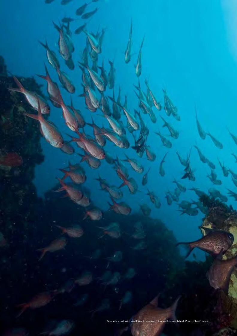
Temperate reef with swallowtail nannygai, close to Rottnest Island. Photo: Glen Cowans.

7
Introduction
Chapter 1 Introduction
Marine bioregional planning is being undertaken
to better protect marine environments, conserve
biodiversity and deliver greater certainty for industry,
the wider community and decision makers about
the marine conservation priorities of the Australian
Government. Section 176 of the Environment Protection
and Biodiversity Conservation Act 1999 (EPBC Act) requires
that, where relevant the Minister for the Environment,
Heritage and the Arts must have regard to a Marine
Bioregional Plan when making decisions under the EPBC
Act.
Marine bioregional planning is also the process through
which the Australian Government identifies areas within
Commonwealth waters for inclusion in the National
Representative System of Marine Protected Areas (MPAs).
The guidelines the Government is using to develop the
National Representative System of MPAs have been
agreed with the States and the Northern Territory. See
<www.environment.gov.au/coasts/mpa>.
Marine Bioregional Plans will guide Government
decision-makers and marine users by:
describing each Region’s conservation values,
including mapping sites of importance for protected
species and communities, and ecological processes;
•
identifying regional priorities for action, based on
an assessment of threats to conservation values
and long-term policy goals; and
developing strategic guidance for proponents and
decision-makers. For example, providing proponents
with a regional context to national guidelines
will enable them to better consider whether their
action might result in a significant impact (see
Appendix B). Plans may also include guidance on
the type of information that should be included
with referrals under the EPBC Act or the monitoring
requirements that may be required for certain
activities or locations within a Region.
Each Marine Region is divided into bioregions based
on ecological similarities, species distribution and
oceanographic and seafloor characteristics1. The South-
west Marine Region has seven bioregions, which are
described in Chapter 2. These bioregions reflect our
understanding of the Region’s ecology and underpin the
planning process.
1 For the purpose of this document, ‘bioregion’ means provincial bioregion as defined in the Integrated Marine and Coastal Regionalisation of Australia Version 4.0.
•
•
Seawhips (octocorals) extending from fine sands, Central Western Province, 418 m deep. Photo: CSIRO.
8
The
Sou
th-w
est
Mar
ine
Bio
regi
on
al P
lan
: B
iore
gio
nal
Pro
file 1.1 The Bioregional Profile of
the South-west Marine Region
The South-west Marine Region encompasses
Commonwealth waters from the eastern end of Kangaroo
Island, South Australia, to offshore of Shark Bay in
Western Australia (Figure 1.1). It covers 1.3 million km2
of ocean and also includes the airspace above the water
and the seabed below. The Region is described in more
detail in Chapter 2. In this Bioregional Profile, the terms
the Region, and the South-west Marine Region are used
interchangeably to refer to the Commonwealth waters
defined above.
The objectives of the South-west Bioregional Profile are
to describe:
the conservation values of the Region – including
marine species, communities and places already
specifically protected under legislation, and those
identified through the planning process as key
ecological features;
the considerations and information that will guide
the identification of MPAs; and
ecosystems and human activities.
In addition to this Introduction, the Bioregional Profile
includes five other chapters, and appendices:
Chapter 2 – The marine environment of the South-west
Marine Region describes the biophysical and ecological
characteristics of the Region, with particular focus on
ecosystem structure and functioning.
Chapter 3 – Conservation values of the South-west Marine
Region summarises and describes the biodiversity and
heritage features that are considered of conservation
value in the South-west Marine Region.
Chapter 4 – Establishing new marine protected areas
in the South-west Marine Region introduces the goals
and principles of the Australian Government for the
establishment of the Commonwealth component of the
National Representative System of MPAs and explains
their application to the South-west Marine Region.
Chapter 5 – Human activities and the South-west Marine
Region outlines the human activities that take place
in the Region. It also provides a short overview of the
population and the historical development of the South
Australian and Western Australian economies adjacent to
the Region.
1.
2.
3.
Chapter 6 – Developing a South-west Marine Bioregional
Plan: next steps describes the stages of marine
bioregional planning beyond the Bioregional Profile, and
opportunities for stakeholder participation.
Appendix A – International conventions and agreements on
the marine environment describes Australia’s international
commitments to manage the marine environment.
Appendix B – An overview of the legislative framework
for environmental protection and biodiversity conservation
in Commonwealth waters explains Australia’s national
legislation for managing its marine areas.
Appendix C – Nationally Protected Species in the South-west
Marine Region lists all the species known to occur and
those which may occur in the Region that are protected
under the EPBC Act.
Appendix D – South-west Marine Region Protected Species
Group Report Cards provides detailed information about
species protected under the EPBC Act. Report Cards on
species groups outline their ecology, areas of particular
importance, interactions with human activities, threats to
their survival and mitigation measures currently being
used.
A decapod crustacean swimming over fine sediments. Central Western Province, 411 m deep. Photo: CSIRO.

9
Introduction
1.2 Supporting information
A number of separate reports were commissioned
to consolidate available information to support the
development of this Bioregional Profile. Those reports
contain further details on the natural environment and
human uses of the Region and are available online at
<www.environment.gov.au/coasts/mbp/south-west>.
Marine bioregional planning has a strong focus on
understanding the natural environment. A scientific
workshop was held in September 2006 to bring together
marine scientists with specific experience and expertise
in the Region. The aim was to take stock of current
knowledge and theory about the way marine ecosystems
function in the Region. It also helped to ensure
that the Bioregional Profile and subsequent Marine
Bioregional Plan are based on the most comprehensive
understanding possible, with an explicit recognition of
the uncertainties due to gaps in the information base.
The outcomes of the workshop are also available online
at <www.environment.gov.au/coasts/mbp/south-west>.
The Bioregional Profile is intended to help stakeholders
and the public to participate in the development of the
South-west Marine Bioregional Plan. The Department of
the Environment, Water, Heritage and the Arts welcomes
any contribution from the public about information
that may be relevant to bioregional planning within
the South-west Marine Region. The Department of the
Environment, Water, Heritage and the Arts will consult
with stakeholders to discuss the contents of the
Bioregional Profile and explain subsequent steps in the
planning process.
Key references and further readings
Australian and New Zealand Environment and
Conservation Council, Task Force on Marine
Protected Areas (ANZECC TFMPA), 1998, Guidelines for
Establishing the National Representative System of Marine
Protected Areas, Environment Australia, Canberra,
<www.environment.gov.au/coasts/mpa>, accessed
07/05/07.
Department of the Environment and Heritage (DEH),
2006, A Guide to the Integrated Marine and Coastal
Regionalisation of Australia Version 4.0, DEH, Canberra,
<www.environment.gov.au/coasts/mbp/publications/
imcra-4>, accessed 07/05/07.
Department of the Environment and Water Resources
(DEW), 2006, Characterisation of the Marine Environment of
the South-west Marine Region: Perth Workshop Report, DEW,
Canberra, <www.environment.gov.au/coasts/mbp/
south-west>.
Legislation
Environment Protection and Biodiversity Conservation Act
1999 (Cth), <www.environment.gov.au/epbc/about>,
accessed 07/05/07.
Dolphin. Photo: Kevin Smith, Marine Life Society of South Australia.

10Southern rock lobster. Photo: Marine Life Society of South Australia.

11
The Marine Environment
Chapter 2 The Marine Environment of the South-west Marine Region
The South-west Marine Region comprises Commonwealth
waters and seabed from the eastern end of Kangaroo
Island, South Australia, to 70 km offshore from Shark
Bay, Western Australia, and covers an area of some
1.3 million km2 (Figure 2.5). The Region is bounded
inshore by the outer limit of the State waters
jurisdictional boundary, (which generally extends out
to three nautical miles from the territorial sea baseline1)
and offshore by the outer limit of the Australian
Exclusive Economic Zone (EEZ), 200 nautical miles from
the low water mark (see Figure 2.1 for a description of
maritime zones). The Region also includes the air space
above its waters.
The Region is adjacent to, but does not cover, the State
waters of South Australia and Western Australia. This
chapter is primarily focused on describing features
and ecological processes in the Commonwealth waters.
However, in some instances features and ecological
processes occurring in State waters are identified
because:
they are important to species listed as threatened
or migratory under the EPBC Act, which are
protected as matters of national environmental
significance (see Chapter 3 and Appendix B
for further information on matters of national
environmental significance); and
1 While the territorial sea baseline is usually at the low water mark, the baseline extends across the openings of bays (e.g. Spencer Gulf) and rivers, and extends around some coastal islands.
•
there is connectivity between features and
ecological processes that link State waters and
the Commonwealth marine area of the South-west
Marine Region.
The Region encompasses waters over the continental
shelf, the continental slope, the continental rise and
the abyssal plains. It also includes the Diamantina
Fracture Zone, which reaches depths of approximately
5900 m (see separate map in the envelope inside the
back cover). The shallower waters of the Region are
found on the continental shelf where depths range from
appropximately 10-200 m. The meeting point of the
shelf and slope is often referred to as the ‘shelf break’.
The continental slope of the Region is incised by a large
number of submarine canyons, more than anywhere else
in Australia.
From a global perspective, the South-west Marine Region
is generally characterised by low levels of nutrients and
high species biodiversity, including a large number of
species found nowhere else in the world. The biological
communities comprise species of temperate origin,
which, in the north of the Region, mix with tropical and
subtropical species. Broadly, these characteristics are
caused by the influence of the Leeuwin Current, the low
level of run-off from the land and the relatively stable
recent geological history. How these factors influence
the ecosystems in the Region are discussed in the
following sub-sections.
•
Figure 2.1 Australia’s maritime zones
For a more detailed description of Australia’s Maritime zones see Australia’s Ocean’s Policy, Appendix 2 <www.environment.gov.au/coasts/mbp/south-west>.

12
The
Sou
th-w
est
Mar
ine
Bio
regi
on
al P
lan
: B
iore
gio
nal
Pro
file The Geomorphology of the Region
The Region has been relatively stable throughout its
recent geological past. This has shaped a continental
shelf that has high wave exposure and is punctuated
with coastal features such as island groups and fringing
coastal reefs providing sheltered habitats for marine
communities.
The continental slope of the Region comprises some of
Australia’s most complex networks of submarine canyons.
The Region also contains some of the largest areas of
abyssal plains within Australia’s Exclusive Economic Zone
and thus contains some of the most extensive deep-
water benthic environments. The Naturaliste Plateau is
Australia’s deepest temperate-water marginal plateau
and is separated from the shelf by the Naturaliste
Trough. It forms an extensive area (the entire feature
is approximately 90 000 km2) of deep-water habitat
between 2000-5000 m deep. Similarly, the Diamantina
Fracture Zone, a very deep area of complex topography
featuring troughs with depths of approximately
5900 m and ridges that rise up from the seafl oor to
approximately 4000 m deep, provides unique and varied
deep-water habitats.
Oceanography and other ecological drivers
There are a number of ocean currents in the Region,
including the Leeuwin Current, the deeper subsurface
Leeuwin Undercurrent on the west coast, the Flinders
Current on the south coast, and the seasonal, coastal
Capes Current and Cresswell Current (Figures 2.2, 2.3).
The Leeuwin Current is the ‘signature current’ of the
Region because of its extent and signifi cant impact
on the biological productivity of ecosystems and
biodiversity. The Leeuwin Current is a shallow and
narrow current (less than 300 m deep and 100 km wide)
that transports warm, nutrient-depleted water from
the tropics southward along the shelf break and outer
parts of the shelf of the entire Region and south-east
to Tasmania’s North-west Cape. Although the Leeuwin
Current fl ows all year round, the strength of its fl ow
shows a marked seasonal variation with the strongest
fl ows occurring during winter. During summer, the
Leeuwin Current weakens to the point that its infl ow to
the Great Australian Bight is largely absent.
The Leeuwin Current originates in the tropical waters of
the Indian Ocean as the result of a large-scale difference
in water density between the warmer, lower salinity
waters fl owing through the Indonesian Archipelago and
the cooler, more saline ocean waters off south-western
Australia. The difference in water density causes a
change in sea level of approximately 0.5 m between the
waters off the northern and southern coasts of Western
Australia. The sea level difference, combined with the
Earth’s rotation, gives origin to the Leeuwin Current,
which accelerates as it runs southward.
The Leeuwin Current strongly affects the ecology
of the Region in a number of ways. In nutrient-
poor waters, production hinges on the import of
nutrients from deeper waters into surface waters
through upwelling and meso-scale cyclonic eddies
(50-200 km diameter eddies that spin clockwise and
in some cases lift deeper water toward the surface).
The Leeuwin Current suppresses predictable large-
scale upwellings on the west coast. In some areas it
interacts with seafl oor features and other currents
to generate relatively small, periodic upwellings that
locally enhance nutrient levels (Figures 2.3 and 2.4). As
Figure 2.2 Major ocean currents in Australian waters
CSIRO Marine Research

13
The Marine Environment
a result, the Leeuwin Current plays an important role
in maintaining low levels of productivity on the west
coast. Consequently, Australia’s west coast is an area
that can only support relatively small fisheries compared
with all other areas with eastern boundary currents in
the world, such as the Humboldt Current off Peru and
the Benguela Current off Africa.
The interactions of the Leeuwin Current with seafloor
features at the shelf break also leads to the formation
of meso-scale eddies. Such eddies are known to occur in
predictable locations; off Shark Bay, the western edge
of the Houtman Abrolhos Islands, south-west of Jurien
Bay, the Perth Canyon, south-west of Cape Naturaliste
and Cape Leeuwin, south of Albany, Esperance and
Eyre Peninsula (Figure 2.4). Scientists think that
eddy systems may have a profound effect on pelagic
production in the Region, driving offshore production by
transporting nutrients and entire pelagic communities
offshore and also generating upwellings of deeper water
that are higher in nutrients. However, these processes
have not yet been studied in detail. A major challenge
to understanding their importance in the Region is the
complexity and variability of eddy systems. For example,
there are both clockwise and anti-clockwise eddies that
form on both the south and west coasts and they may
have different physical characteristics – eddies can have
cool water or warm water in their core or they may be
associated with ascending or descending water.
Figure 2.3 Schematic of major ocean currents flowing through the South-west Marine Region
Inset: major currents contributing to the Cape Mentelle upwelling
Bathymetric image Geoscience Australia, current schematic after McClatchie et al. 2006.
Ornate cowfish. Photo: Marine Life Society of South Australia.

14
The
Sou
th-w
est
Mar
ine
Bio
regi
on
al P
lan
: B
iore
gio
nal
Pro
file Figure 2.4 Ocean colour image showing the eddy structure of the Leeuwin Current off the west coast
Ocean colour image NASA/GSFC Orbimage SeaWiFS Project. Water higher in chlorophyll (shown light green) is located on the shelf, and is swept into the Leeuwin Current, spiralling off to form eddies.
The Leeuwin Current plays a crucial role in the
distribution of species in the Region. Its warm water
transports tropical and sub-tropical species, which
become established in areas further south than they
otherwise would. For instance, it is because of the
Leeuwin Current that a number of tropical fish and hard
coral species are found as far south as Rottnest Island
(latitude 32°S). The Leeuwin Current and the deeper
Flinders Current are also likely to aid the large-scale
movements of a number of migratory species.
The ecology is also greatly influenced by the lack of river
discharge into the Region. The few significant rivers
adjacent to the Region flow intermittently, and their
overall discharge is low. Consequently, there is a limited
amount of terrigenous (originating from the land)
nutrient inputs. When combined with the suppression of
large-scale upwelling, discussed above, limited nutrient
input from the land reinforces the Region’s relatively
nutrient-poor status compared with many other marine
environments.
The low discharge of rivers and the generally low rate
of biological productivity also results in low turbidity
(suspended sediments), making the waters of the Region
relatively clear. This means that light can penetrate to
greater depths allowing a number of light-dependent
species and associated communities to be found in
waters deeper than those in which they live in other
parts of Australia. For instance, macro-algae and seagrass
are found at depths of up to 120 m in some parts of the
Region.
Biodiversity in the South-west Marine Region
The flora and fauna of the Region are a blend of tropical,
subtropical and temperate species. Temperate species
dominate the southern and eastern parts of the Region
while tropical species become progressively more
common in the north.
The South-west Marine Region is known for its high
species diversity and high numbers of endemic species
(species that are found nowhere else in the world),
and there are many more species yet to be discovered.
Of the known species, more than 1000 species of
macro-algae, between 17 and 22 species of seagrass,
600 species of fish, 110 species of echinoderm and 189
species of ascidians have been recorded in the Region.
In the nearshore area of southern parts of the Region
approximately 85 per cent of fish species, 95 per cent
of molluscs and 90 per cent of echinoderms are thought
to be endemic. By comparison, it has been estimated
that only 13 per cent of fish, 10 per cent of molluscs
and 13 per cent of echinoderms are endemic to tropical
regions of Australia. The Region also contains a number
of endemic species that are commercially fished, such as

15
The Marine Environment
the western rock lobster and dhufish. A global study of
coral reef biodiversity hotspots has also found that while
the west coast of Western Australia from Ningaloo reef
(outside the Region) to Rottnest Island has moderate
to high species richness, it is also one of the global
hotspots for endemism. Similarly, recent studies of
demersal fish communities on the continental slope of
the west coast revealed high species richness compared
with the North Atlantic and northern Pacific Oceans.
The high species diversity of the Region is largely
attributed to the lack of mass extinction events
associated with unfavourable environmental conditions
such as glaciations over the recent geological past
and the moderating influence of the Leeuwin Current
over about the last 50 million years. The high species
richness (for example, in hard corals, demersal fish,
seagrasses and macro-algae), is also in part due to the
biogeographic overlap of the ranges of temperate and
tropical species. The high endemism in the Region is
partly the product of the long period (the last 80 million
years) during which the marine flora and fauna in the
Region have been isolated from species occurring around
other land masses.
The south coast has not been as well studied as the west
coast. However, a growing body of research indicates
that its waters support a rich diversity of organisms.
The Great Australian Bight is known to have one of the
world’s most diverse soft sediment ecosystems: recent
sampling studies have revealed assemblages that include
360 different species of sponge, 138 species of ascidians
and 93 species of bryozoans, many of which were newly
discovered species.
The South-west Marine Region is an area of global
significance for breeding or feeding grounds for a
number of threatened marine animals, including
Australian sea lions, southern right whales and white
sharks. Scientists have recently identified the south-
western corner of Australia as an important area for
beaked whales, which are the least known species group
of whales. The Region also provides habitat for a large
number of seabird species that nest on nearby islands
and coastline.
Our understanding of species biodiversity and endemism
in the deeper parts of the Region, on the continental
slope, continental rise and abyssal plain is poor when
compared with our knowledge of shallower coastal and
shelf communities. Of all the oceanic regions under
Australia’s jurisdiction, the South-west Marine Region
includes the deepest areas and the largest expanse
of continental rise. Species unknown to science are
undoubtedly yet to be discovered in these unique
environments. It is expected that the biodiversity
values in the Diamantina Fracture Zone, the Naturaliste
Plateau, and the numerous submarine canyons that
incise the continental slope are high compared with
other parts of the world.
Compound ascidian. Photo: David Muirhead, Marine Life Society of South Australia.

16
The
Sou
th-w
est
Mar
ine
Bio
regi
on
al P
lan
: B
iore
gio
nal
Pro
file 2.1 The bioregions of the
South-west Marine Region
The Integrated Marine and Coastal Regionalisation of
Australia Version 4.0 (IMCRA v.4.0) identifies seven
bioregions1 in the South-west Marine Region (Figure
2.5). The Regionalisation provides a spatial framework
to represent at a broad-scale the distribution patterns of
marine life in the Region. IMCRA v.4.0 is the product of
the combination of the 1996 Interim Marine and Coastal
Regionalisation of Australia, which provided a marine
regionalisation of waters on the continental shelf,
with the 2005 National Marine Bioregionalisation, a
regionalisation of off-shelf waters. Within IMCRA v.4.0,
the nomenclature of the bioregions has used the term
‘IMCRA’ to identify those bioregions that lie over the
continental shelf. For the purposes of this Bioregional
Profile the term ‘IMCRA’ has been replaced with ‘Shelf’
1 For the purpose of this document, ‘bioregion’ means provincial bioregion as defined in the Integrated Marine and Coastal Regionalisation of Australia Version 4.0.
to distinguish shelf bioregions from those offshore. The
bioregions described in this Bioregional Profile are:
Southwest Shelf Transition;
Central Western Province;
Southwest Shelf Province;
Southwest Transition;
Great Australian Bight Shelf Transition;
Spencer Gulf Shelf Province; and
Southern Province.
Each bioregion is described below in terms of the
characteristics of its marine environment, including
physical structure, biological communities and ecological
processes. Chapter 4 discusses the bioregions in relation
to the identification of areas suitable for the National
System of MPAs.
•
•
•
•
•
•
•
Figure 2.5 Bioregions of the South-west Marine Region (IMCRA v.4.0)

17
The Marine Environment
2.1.1 Southwest Shelf Transition
Figure 2.6 The Southwest Shelf Transition
The Southwest Shelf Transition is a nearshore bioregion
that covers the area of continental shelf from Perth
to Kalbarri, and extends out to the edge of the shelf
(Figure 2.6). The Commonwealth waters of this
bioregion extend from the limit of Western Australian
State waters to the shelf-break. Eighty-one per cent of
the Southwest Shelf Transition is under the jurisdiction
of the Commonwealth.
The Leeuwin Current has a significant influence on
the biodiversity of this bioregion as it pushes sub-
tropical water southward along the western edge of
the bioregion. Ridges and inshore lagoons characterise
the seafloor of the continental shelf of this area. The
bioregion has high biodiversity and contains a large
number of species that are found nowhere else in the
world.
The Houtman Abrolhos Islands off Geraldton are
renowned for their high species diversity, coral reefs
and a unique mix of temperate and tropical species.
These islands are also an important breeding site for
seabirds, and are the northernmost breeding site for
the Australian sea lion. The Houtman Abrolhos Islands,
inshore lagoons and other islands further south, such
as the Beagle Islands, provide important areas of shelter
for shallow water communities in a bioregion that is
otherwise exposed to ocean swells. The inshore lagoons
are known for the enhanced benthic productivity of
their macro-algae and seagrasses and for supporting
breeding and nursery aggregations of numerous marine
species.
The western rock lobster is an iconic species of the
bioregion with an important trophic role for a range of
inshore species that prey on juvenile lobsters.
Geomorphology This bioregion consists of a narrow continental shelf,
ranging from approximately 40-80 km wide that is noted
for its physical complexity. It includes a series of near-
shore ridges and depressions that form inshore lagoons,
a smooth inner shelf plain, a series of offshore ridges
and a steep, narrow outer shelf. The near-shore ridges
are formed by eroded limestone reefs and pinnacles
that stand 10-20 m above the seafloor. The edge of the
inner shelf plain is marked by a series of broken offshore
ridges that extend north to the northern limits of the
bioregion, where they emerge to support the tropical
carbonate reef growth of the Houtman Abrolhos Islands
(Figure 2.7).

18
The
Sou
th-w
est
Mar
ine
Bio
regi
on
al P
lan
: B
iore
gio
nal
Pro
file
Oceanography
The Leeuwin Current contains warm tropical waters low
in nutrients and salinity, and follows a meandering path
southward along the outer limit of the bioregion. It
follows the shelf break and forms eddies at predictable
locations: south-west of Shark Bay, adjacent to the
Houtman Abrolhos Islands, Jurien Bay and Perth
Canyon. The current impedes large-scale upwellings on
the west coast, although weak, local upwellings may
sporadically occur on the outer shelf. Eddies generate
cross shelf currents that provide connectivity between
the continental shelf and deeper waters. They provide
nutrient-rich waters on the continental shelf that
enhance biological productivity. The Capes Current,
generated in the Southwest Shelf Province off Cape
Mentelle by southerly winds during summer, transports
cooler, saline water, together with the larvae of
temperate species, northward along the inner shelf.
Biological communities
The bioregion contains a diversity of tropical and
temperate marine life including a large number of
endemic fauna species. The west coast of Western
Australia, from Ningaloo Reef down to Rottnest Island,
is a global hotspot for endemism. Species diversity of
seagrasses in this bioregion is the highest in the world,
with 14 species occurring.
The inner shelf of the bioregion, extending between
0-50 m deep, includes distinct ridges of limestone reef
with extensive beds of macro-algae (principally Ecklonia
spp.). These inshore lagoons are inhabited by a diverse
range of coralline algae, sponges, molluscs, crustaceans
and demersal and pelagic fish. Extensive schools of
migratory fish visit the area annually, including herring,
garfish, tailor, and Australian salmon. These small to mid-
sized predators feed on smaller pelagic fish and squid,
and in turn are preyed upon by larger predators, such
as mulloway, snapper, samson fish, Spanish mackerel
and whaler sharks. Small pelagic fish including herring,
sardine, scaly mackerel, jack mackerel, yellow tail, blue
mackerel, anchovy, blue sprat and sandy sprat, are
considered a particularly important trophic link between
plankton communities and larger fish-eating predators
(Figure 2.14). Seagrass meadows occur in areas with less
exposure and in the inter-reef lagoons along exposed
sections of the coast. Benthic communities on the outer
shelf and shelf break are dominated by adult snapper,
while filter feeding sponges and bryozoans dominate the
hard bottom.
Figure 2.7 Bathymetry of the Houtman Abrolhos Islands
Geoscience Australia

19
The Marine Environment
The islands within the bioregion, including the Houtman
Abrolhos and the Beagle Islands provide sheltered,
shallow water habitats for diverse marine communities
including protected species. The Houtman Abrolhos
Islands are the ecological mid-point in a gradient that
extends from the tropical ecosystems of Shark Bay,
south along the shelf to the temperate communities at
Rottnest Island. However, being offshore, these islands
catch more of the fl ow of warm Leeuwin Current waters
than the adjacent lagoons and shorelines. The coral reefs
of the Houtman Abrolhos Islands are the most southern
extensive coral community along the west coast.
Smaller localised pockets do occur as far south as Cape
Naturaliste in the Southwest Shelf Province.
The Houtman Abrolhos Islands have been relatively
well studied and are noted for their high species
diversity, which is attributed to the relatively equal
mix of temperate and tropical species. The reefs around
the islands comprise 184 known species of corals that
support about 400 known species of demersal fi sh,
492 known species of molluscs, 110 known species of
sponges, 172 known species of echinoderms and 234
known species of benthic algae. The Houtman Abrolhos
group of islands are also one of the most important
breeding sites for seabirds in the world, and the
northernmost site of the Australian sea lion’s range.
Ecosystem processes
The inshore lagoons are thought to be important areas
for benthic productivity (Figure 2.8) and recruitment for
a range of marine species. These shallow water, sheltered
environments are located between the shore and the
inner shelf ridge system and extend south well into the
Southwest Shelf Province. They are characterised by
extensive beds of macro-algae, interspersed with areas
of seagrass which provide the primary source of benthic
production inside the 50 m depth contour. Ground
water enrichment may also supplement the supply of
nutrients to the inshore lagoon. The inshore lagoons
provide important habitat for the breeding and nursery
aggregations of a number of species, including the area’s
iconic species, such as western rock lobster, dhufi sh,
pink snapper, breaksea cod, baldchin and blue gropers,
and probably many other reef species.
Western rock lobster, the dominant large benthic
invertebrate in this bioregion, is considered to be
an important part of the food web of the inner shelf.
Particularly when they are small, juvenile lobsters are
preyed upon by a large number of species including
octopus, cuttlefi sh, baldchin groper, blue groper,
dhufi sh, pink snapper, wirrah cod, breaksea cod and
Australian sea lions (Figure 2.9). Western rock lobsters
are very vulnerable to predation during their annual
moults (the stage of their lifecycle when they shed their
hard protective shell so they can grow a larger one),
predominantly during November-December, and to a
lesser degree in April-May of each year. The high biomass
and vulnerability of western rock lobster to predation
suggest that they are an important trophic pathway
for a range of inshore species. Western rock lobster is
the basis of one of Australia’s most valuable commercial
fi sheries. The Western Rock Lobster Fishery was the
fi rst Australian fi shery to be accredited with Marine
Stewardship Council certifi cation.
Figure 2.8 Simplifi ed diagram of productivity in the marine environment
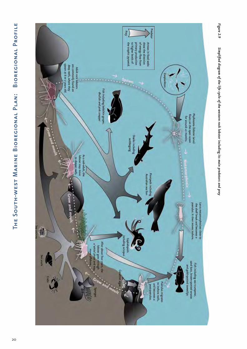
20
The
Sou
th-w
est
Mar
ine
Bio
regi
on
al P
lan
: B
iore
gio
nal
Pro
file
Figure 2.9 Sim
plified diagram of the life cycle of the w
estern rock lobster including its main predators and prey

21
The Marine Environment
Table 2.1 Key ecological features and other important areas of the Southwest Shelf Transition
Feature or area Rationale
Coastal reefs around Kalbarri
Important area for protected species (see Appendix D):Green turtle (foraging area). Although the importance of this area to the species is not well understood, resident adult green turtles are found in this area.
•
Houtman Abrolhos Islands and surrounding waters
Commonwealth waters surrounding the Islands are a key ecological feature (see Chapter 3.1) – the islands support high species biodiversity.Regionally important area for protected species (see Appendix D):
Green turtle (foraging area). Although the importance of this area to the species is not well understood, resident adult green turtles are observed at the reefs of the Houtman Abrolhos Islands;Common noddy (rookery – Pelseart Island);Caspian tern (rookeries – Leo Island, West Wallabi Island and Pelsaert Island);Wedge-tailed shearwaters (rookeries);Bridled tern (rookeries – Gun Island, Leo Island, Pelsaert Island and Little North Island)Osprey (nesting area – Pelseart Island);White-bellied sea eagle (nesting area – West Wallabi Island);Australian lesser noddy (feeding area and rookeries Morley Island, Wooded Island and Pelseart Island). In Australia the Australian lesser noddy is only known to breed in this area and is known to forage between the islands and the continental shelf edge;Australian sea lion* (breeding colony – Easter Group); andHumpback whale (resting area). Sightings of Bryde’s whales also indicate this area may be important for this rarely sighted species.
•
•••••••
••
Inshore lagoons Commonwealth waters within and adjacent to the inshore lagoons are a key ecological feature (see Chapter 3.1) – the lagoons support enhanced benthic productivity and provide important breeding and nursery aggregation areas for marine life.
Fisherman Islands Important area for protected species (see Appendix D): Bridled tern (rookeries).•
Beagle Islands Important area for protected species (see Appendix D): Bridled tern (rookeries).•
Penguin Island Important area for protected species (see Appendix D): Bridled tern (rookeries).•
Lancelin Island Important area for protected species (see Appendix D):Wedge-tailed shearwater (rookery); andBridled tern (rookery).
••
Waters off the mid-west coast, WA
Important area for protected species (see Appendix D):Leatherback turtle (foraging area). Although the importance of this area to the species is not well understood, leatherback turtles are known to feed in pelagic waters along the mid-west coast of WA. Adult leatherback turtles have also been observed feeding in shallow inshore waters in this area.
•
Jurien Bay south to Rottnest Island
Important area for protected species (see Appendix D):Juvenile green turtles (foraging area). Although the importance of this area to the species is not well understood, large juvenile green turtles are observed in this area.
•
Western rock lobster Key ecological feature (see Chapter 3.1) – important trophic pathway for a range of inshore species that prey upon juvenile lobsters.
Small pelagic fish Key ecological feature (see Chapter 3.1) – important trophic link between plankton communities and larger marine predators.
* Due to the closed breeding patterns of Australian sea lions (see Appendix D) and their threatened conservation status, all breeding sites for Australian sea lions are considered as regionally significant.

22
The
Sou
th-w
est
Mar
ine
Bio
regi
on
al P
lan
: B
iore
gio
nal
Pro
file 2.1.2 Central Western Province
Figure 2.10 The Central Western Province
The Central Western Province extends offshore from
the Southwest Shelf Transition to the limit of the EEZ
(Figure 2.10). The entire bioregion lies within the
jurisdiction of the Commonwealth, and within the
South-west Marine Region. It is characterised by a
narrow continental slope incised by many submarine
canyons and the most extensive area of continental rise
in any of Australia’s Marine Regions. Continental rise is
the gentle slope rising from the oceanic depths towards
the foot of the continental slope (see Figure 2.1). A
significant feature within the bioregion are several
eddies hundreds of kilometres in diameter that spin in
an anti-clockwise direction that form off the Leeuwin
Current at predictable locations. The eddies are
ecologically important because they transport shallow
water plankton communities offshore to deeper waters
and under some circumstances are associated with
enhanced productivity in surface waters.
The bioregion includes the Perth Canyon, the largest of
Australia’s submarine canyons, which coincides with a
distinct change in the distribution of marine organisms
and marks the southernmost boundary for numerous
tropical and sub-tropical species. Perth Canyon also
appears to be an important area for blue whales and
other deep-diving whales that feed around the rim
of the canyon. The demersal fish communities on the
continental slope of the bioregion are characterised
by relatively high biodiversity and include at least 31
endemic species.
Geomorphology
This bioregion is characterised by a narrow continental
slope that is heavily incised by many submarine canyons
as far north as Kalbarri. The Perth Canyon, located at
the southern margin of the bioregion, is an order of
magnitude larger than any other canyon in the Region
(Figure 2.11). The Perth Canyon, formed by erosive
processes associated with the ancient Swan River, cuts
into the continental shelf at approximately the 150 m
depth contour, north-east of Rottnest Island. Other
relatively large canyons, such as the Murchison Canyon,
occur in the bioregion but little is known about them as
they have not yet been studied.
The bioregion contains the most extensive area
(52 185 km2) of continental rise on the Australian
margin. The continental rise is located on the edge
of the Perth Abyssal Plain (103 911 km2). There is a
large terrace known as the Carnarvon Terrace on the
continental slope, extending north from the Houtman
Abrolhos Islands at an average of 780 m water depth.

23
The Marine Environment
Oceanography
As in the Southwest Shelf Transition, the Leeuwin
Current is noted for its meandering pattern that
generates anti-clockwise meso-scale eddies. The eddies
form at predictable locations along the shelf break
(south-west of Shark Bay, west of the Houtman Abrolhos
Islands, south-west of Jurien Bay and at the Perth
Canyon, west of Rottnest Island) and drift westward
away from the coast. Mirroring the variability in
strength of the Leeuwin Current, eddies tend to form
predominantly in winter and are particularly frequent
during La Niña events. The Leeuwin Undercurrent travels
northward beneath the Leeuwin Current at between
250-450 m deep over the continental slope.
Biological communities
Our understanding of marine life in this bioregion is
mostly confined to the demersal fish on the continental
slope. Scientists have described 480 species of demersal
fish that inhabit the slope of this bioregion and 31 of
these are considered to be endemic to the bioregion. In
general, the density of demersal fish in this bioregion
is low, especially when compared with the South-east
Marine Region. Fish density is highest at the shelf
break and uppermost parts of the slope (approximately
200-300 m water depth) where large adult snappers
dominate. Juvenile snappers inhabit the inshore areas
before migrating to offshore reefs as adults to breed and
feed in deeper waters. These fish live here because it is
an area of high energy, where water circulation becomes
more complex relative to the continental shelf, and prey
is relatively abundant compared with the shelf.
At greater depth on the slope (below 400 m water
depth) demersal fish communities are dominated by
many relatively small, benthic species (grenadiers,
dogfish and cucumber fish). Many of these species
display physical adaptations to feed on the seafloor,
such as a mouth position adapted to bottom feeding,
and many do not appear to undertake daily vertical
migrations in their feeding habits. This is not surprising
given that the abundance of suitable pelagic prey
species such as Myctophids (lantern fish) is likely to
be considerably lower compared with those on the
south-eastern slope of Australia. This means that in this
bioregion benthic prey species are likely to be relatively
more important than pelagic prey species for demersal
fish. The shelf break and upper parts of the slope are
considered important for deep diving whales such as
toothed and beaked whales that may be hunting fish
and squid feeding on the slope. Deep sea crabs, such
as the champagne crab and crystal crab, inhabit the
seafloor of the slope.
Ecosystem processes
The meso-scale eddies of this bioregion are important
transporters of nutrients and plankton communities
(Figure 2.4). Anti-clockwise eddies entrain water from
the outer shelf along with its plankton communities,
and transport these communities far offshore into the
Indian Ocean, where they are consumed by oceanic
communities. On the other hand, clockwise eddies may
play an important role in ‘lifting’ deep water, which can
be relatively cooler and richer in nutrients, toward the
surface, where it can enhance production of plankton
Figure 2.11 Bathymetry of the Perth Canyon
Geoscience Australia

24
The
Sou
th-w
est
Mar
ine
Bio
regi
on
al P
lan
: B
iore
gio
nal
Pro
file communities that then attract aggregations of marine
life. These are important ecosystem processes in a
nutrient-poor environment. There is still much to be
understood about the ecological processes associated
with eddies and their importance in this bioregion.
The submarine canyons of this bioregion are key
ecological features because they are thought to be
linked to the localised small periodic upwellings that
enhance productivity and attract aggregations of marine
life (Figure 2.12). The Perth Canyon is prominent among
these canyons because of its large size and ecological
importance. Acting as a major constriction of the shelf,
its topography is thought to contribute to frequent
formation of eddies and frontal structures that occur to
the north of Rottnest Island. The Perth Canyon marks
the southern boundary for numerous tropical organisms
on the shelf, including sponges, corals, decapods and
xanthid crabs. The upwelling of deep ocean currents
in the canyon creates a nutrient-rich coldwater oasis
under the warm waters of the Leeuwin Current. In this
setting, swarms of krill and squid seasonally ‘boom and
bust’ attracting pygmy blue whales, toothed whales and
unidentified species of beaked whales. During the day,
aggregations of krill and small fish gather along the
canyon’s north-eastern rim, making up a deep scattering
layer. Higher up, dense ‘balls’ of krill – up to 250 m
wide and 50 m deep – have been observed at around
300 m deep just below the Leeuwin Current. By day,
blue whales dive to feed on these krill ‘balls’ and the
deep scattering layer, while at night, the krill rise to
within 50 m below the surface allowing the whales to
feed at shallower depths.
Figure 2.12 Simplified diagram of upwelling and aggregations of marine life in the Perth Canyon
Inset 1. Location of the Perth Canyon – Copyright Commonwealth of Australia. Inset 2. Perth Canyon bathymetry – Geoscience Australia.

25
The Marine Environment
Table 2.2 Key ecological features and other important areas of the Central Western Province
Feature or area Rationale
Demersal slope fish communities
Key ecological feature (see Chapter 3.1) – high species biodiversity.
West Coast Canyons and adjacent shelf break
Key ecological feature (see Chapter 3.1) – associated with enhanced productivity and feeding aggregations of marine life. They are unique seafloor features.Important area for protected species (see Appendix D):
Pygmy blue whale (feeding aggregation area – Perth Canyon). Fin whales have also been observed in the Perth Canyon and it is thought that sei whales may also feed there.
•
Meso-scale eddies (predictable locations south-west of Shark Bay, west of the Houtman Abrolhos Islands, south-west of Jurien Bay and west of Perth Canyon)
Key ecological features (see Chapter 3.1) – associated with enhanced productivity and feeding aggregations of marine life.
Waters off the mid-west coast, WA
Important area for protected species (see Appendix D): Leatherback turtle (foraging area). Although the importance of this area to the species is not well understood, leatherback turtles are known to feed in pelagic waters along the mid-west of WA.
•
Gray’s beaked whale. Photo: Nick Gales, Australian Government Antarctic Division.

26
The
Sou
th-w
est
Mar
ine
Bio
regi
on
al P
lan
: B
iore
gio
nal
Pro
file 2.1.3 Southwest Shelf Province
Figure 2.13 The Southwest Shelf Province
The Southwest Shelf Province is a nearshore bioregion
that extends from Rottnest Island to Point Dempster,
approximately 185 km east of Esperance (Figure 2.13).
Approximately 78 per cent of the bioregion is under the
jurisdiction of the Commonwealth. At the south-west
corner of Australia at Cape Leeuwin, the Leeuwin Current
changes direction from a southbound to an eastbound
current. The bioregion is characterised by sub-tropical
species in the north and temperate species along its
southern extent. Species diversity of seagrasses and
macro-algae is very high. A small upwelling of nutrient-
rich water off Cape Mentelle during summer increases
productivity locally, and this attracts aggregations of
marine life. The sheltered waters of Geographe Bay and
other inshore lagoonal areas support extensive seagrass
beds that in turn provide important nursery habitat for
a range of marine species. Further east, the Recherche
Archipelago supports high species diversity of fish,
molluscs, sponges and macro-algae. The islands provide
shelter for marine communities and important haul-out
(resting areas) and breeding sites for Australian sea lions
and New Zealand fur seals. The sheltered bays along the
south coast are important southern right whale calving
areas.
Geomorphology
The Southwest Shelf Province consists of an area of
narrow continental shelf. The northern limits of the
bioregion are an extension of the seafloor described in
Chapter 2.1.1 (Southwest Shelf Transition). It includes
features such as limestone ridges, depressions defining
an inshore lagoon and a relatively smooth inner shelf
plain that meets the South Bank Ridge on the outer
shelf, and islands providing important habitat, such as
Rottnest Island. The shelf progressively broadens to form
the relatively sheltered waters of Geographe Bay before
narrowing once again at Cape Mentelle.
On the south coast, the coastal geomorphology changes
from the predominant limestone reefs to eroded
Precambrian rocks, which form islands and submerged
reefs such as the extensive reef systems of the Recherche
Archipelago and those south of Albany. These reefs
provide shelter for the coast, which would otherwise be
exposed to high wave energy from the Southern Ocean.
Oceanography
This bioregion marks the change in direction of the
Leeuwin Current, from a southbound to an eastbound
current after passing Cape Leeuwin. The Leeuwin
Current generates eddies at predictable locations (Cape

27
The Marine Environment
Naturaliste, Cape Leeuwin and offshore of Albany and
Esperance), presumably as a result of changes in seafloor
topography and topographical features. On the inner
shelf, summer winds generate coastal currents – the
Cresswell Current on the south coast and the Capes
Current on the west coast – that flow in the opposite
direction to the Leeuwin Current. The Capes Current is
also associated with a seasonally predictable upwelling
of nutrient-rich water off Cape Mentelle. Upwellings
of cold deep water have also been observed in recent
studies of the Recherche Archipelago.
Biological communities
The faunal assemblages in this bioregion resemble
the cooler water communities to the east, although
a distinct sub-tropical element is maintained by the
Leeuwin Current. The south coast of the bioregion
is characterised by a relatively higher diversity of
temperate macro-algal species compared with the
Southwest Shelf Transition. These colonise the exposed
rocky shorelines and rocky reefs, while extensive
seagrass beds are found in sheltered bays, including
Geographe Bay, estuaries and in the lee of some reef
systems. Similar to the Southwest Shelf Transition,
seagrass beds in this bioregion are noted for their high
species biodiversity and endemism. In shallow waters,
western blue groper and queen snapper (blue morwong)
are prominent large benthic feeders. Small pelagic fish
including herring, sardine, scaly mackerel, jack mackerel,
yellow tail, blue mackerel, anchovy, blue sprat and sandy
sprat are thought to be particularly important trophic
links between plankton communities and larger fish-
eating predators (Figure 2.14).
The omnivorous reef predators, the Western Australian
dhufish and smaller breaksea cod, disappear from the
shallow shelf assemblage just to the east of Albany, and
are replaced by mulloway, harlequin cod and ‘nannygai’
Bight redfish. Greenlip abalone can reach a significant
biomass on shallow reefs (less than 40 m deep) as they
do to the east along the entire southern Australian
coast. Greenlip abalone are not seen on the coastal
reefs of the west coast of the Australian continent. East
of Albany, the dominant lobster species changes from
the western rock lobster to the southern rock lobster.
The latter is common throughout temperate Australia
and New Zealand. In this bioregion there is a notable
increase in the ratio of benthic fish to crustaceans.
Crustaceans appear to be less important in structuring
shallow benthic communities here than in bioregions
to the north and to the south-east of the Murray River
mouth, around the Bonney Upwelling and Tasmania.
Adjacent to Commonwealth waters, the extensive area
of granite reef (35 203 km2 of reef habitat) and seagrass
habitat of the Recherche Archipelago is noted for its
high diversity of warm temperate species including 263
known species of fish, 347 known species of molluscs,
300 known species of sponges, and 242 known species of
macro-algae. The many near-shore islands in this area are
haul-out (resting areas) and breeding sites for Australian
sea lions and New Zealand fur seals. The sheltered bays
along the south coast are important calving areas for
southern right whales.
Temperate reef with swallowtail nannygai. Photo: Glen Cowans.

28
The
Sou
th-w
est
Mar
ine
Bio
regi
on
al P
lan
: B
iore
gio
nal
Pro
file
Ecosystem processes
On the west coast, the inshore lagoons of Geographe Bay
and waters surrounding Rottnest Island are important
areas for benthic productivity and as feeding, resting,
breeding and nursery grounds for a range of marine
species (see Southwest Shelf Transition for importance of
the inshore lagoons). Geographe Bay is a large relatively
sheltered area with extensive beds of tropical and
temperate seagrass that are thought to account for about
80 per cent of benthic primary production in the area.
These seagrass beds provide important nursery habitat
for many shelf species, such as dusky whaler sharks that
use the shallow seagrass habitat as nursery grounds for
several years before moving out over the shelf to their
adult feeding grounds along the shelf break. Shoals
of small planktivorous fish (anchovies, silver sprat,
pilchards, garfish and herring) and squid are also found
in the bay. These species are preyed upon seasonally by
large mobile schools of predatory fish, such as Australian
salmon, snapper, dhufish, samson fish and whaler sharks.
Other important ecological areas that are key to
maintaining the biodiversity of the bioregion are the
species-rich Recherche Archipelago and the seasonally
productive waters off Cape Mentelle. The predictable
summer upwelling off Cape Mentelle draws water
from the base of the Leeuwin Current (where nutrient
levels are higher) up the continental slope and on
to the continental shelf, where it sustains blooms of
phytoplankton in surface waters. Higher densities of
phytoplankton provide the basis of an extended food
chain characterised by aggregations of fish, which occur
here at higher densities than in surrounding waters. It is
also likely that detritus from these pelagic communities
supports local hotspots of benthic biodiversity off Cape
Mentelle.
Figure 2.14 Simplified diagram of the predators and prey of small pelagic fish

29
The Marine Environment
Table 2.3 Key ecological features and other important areas of the Southwest Shelf Province
Feature or area Rationale
Inshore lagoons Commonwealth waters within and adjacent to the inshore lagoons are a key ecological feature (see Chapter 3.1) – the lagoons support enhanced benthic productivity and provide important breeding and nursery aggregation areas for marine life.
Rottnest Island Important area for protected species (see Appendix D):Wedge-tailed shearwater (rookery); andBridled tern (rookery).
••
Waters from Rottnest Island to Geographe Bay
Important area for protected species (see Appendix D):Loggerhead turtle (foraging area). Although the importance of this area to the species is not well understood, resident adult loggerhead turtles and sub-adult turtles are known to forage in this area; andHumpback whale (resting area). Recent surveys have also detected southern right whales in the area and have shown an increasing number of pygmy blue whales using the Bay in spring and also passing through the shelf area between Cape Naturaliste and Rottnest Island. However, the ecological or functional significance of the area to the species is unclear.
•
•
Geographe Bay Commonwealth waters within and adjacent to Geographe Bay are a key ecological feature (see Chapter 3.1) – these waters support enhanced benthic productivity and high species biodiversity; they also provide important feeding, resting, breeding and nursery aggregation areas for marine life.
Cape Mentelle upwelling Key ecological feature (see Chapter 3.1) – upwellings enhance pelagic productivity and attract feeding aggregations.
Recherche Archipelago Commonwealth waters surrounding the Archipelago are a regional key ecological feature (see Chapter 3.1) – these waters support high species biodiversity and provide important breeding and resting areas for marine life.Important area for protected species (see Appendix D):
Flesh-footed shearwater (rookeries);Short-tailed shearwater (rookeries);Caspian tern (rookeries);White-bellied sea eagle (nesting area); andAustralian sea lion (breeding colony).
•••••
Waters surrounding Cape Leeuwin/ Flinders Bay
Important area for protected species (see Appendix D):Humpback whale (resting area); andSouthern right whale (calving area).
••
Doubtful Islands Important area for protected species (see Appendix D):Southern right whale (calving area).•
Albany/Cape Riche area Important area for protected species (see Appendix D):Southern right whale (calving area).•
Yokinup Bay/Cape Arid area
Important area for protected species (see Appendix D):Southern right whale (calving area).•
Safety Bay Important area for protected species (see Appendix D):Wedge-tailed shearwater (rookery); andBridled tern (rookery).
••
Cape Hamelin Important area for protected species (see Appendix D):Flesh-footed shearwater.•
Waters of the south-west coast, WA
Important area for protected species (see Appendix D):Leatherback turtle (foraging area). Although the importance of this area to the species is not well understood, leatherback turtles are known to feed in pelagic waters along the south-west of WA.
•
Small pelagic fish Key ecological feature (see Chapter 3.1) – important trophic link between plankton communities and larger marine predators.

30
The
Sou
th-w
est
Mar
ine
Bio
regi
on
al P
lan
: B
iore
gio
nal
Pro
file 2.1.4 Southwest Transition
Figure 2.15 The Southwest Transition
The Southwest Transition is a deepwater bioregion that
extends offshore from the Southwest Shelf Province out
to the limit of the EEZ (Figure 2.15). The entire bioregion
lies within the jurisdiction of the Commonwealth, and
within the South-west Marine Region. The main features
of the bioregion are the Naturaliste Plateau (the
deepest submarine plateau along Australia’s continental
margins), and the deep water mixing that results from
the dynamics of major ocean currents when these meet
the seafloor, particularly the Naturaliste Plateau, the
continental slope and Perth Canyon. Unusually deep
eddies are known to form offshore of Cape Leeuwin,
where some interact with the shallower parts of the
Plateau. There is little available information on biological
communities of this bioregion, however, information on
demersal fish communities indicates that the bioregion
is an area of transition between those communities
found in the Central Western Province and those of the
Southern Province. Scientists also speculate that the
marine communities associated with the Naturaliste
Plateau may have high species diversity and endemism.
Geomorphology
The Southwest Transition is an offshore deepwater
bioregion with a submerged continental fragment as its
dominant seafloor feature – the Naturaliste Plateau. The
Plateau extends across an area of 90 000 km2 of which
only 29 825 km2 is within Commonwealth waters. It is
located west of Cape Leeuwin and Cape Naturaliste in
water depths ranging from 2000-5000 m. It is relatively
flat with a slight northward dip, and has steep southern
and western sides and a more gently sloping northern
side. The Plateau is separated from the Australian
continent by the Naturaliste Trough and two offshore
terraces on the continental slope (average depth 780 m).
Submarine canyons incise the northern parts of the
slope and parts of the Naturaliste Plateau.
Oceanography
The bioregion is characterised by complex water-mixing
that is created by the interaction of ocean currents. The
Leeuwin Current, the Leeuwin Undercurrent, the deeper
Flinders Current and the Western Australian Current
interact with each other and with seafloor features
such as the Perth Canyon to the north, the continental
slope and the Naturaliste Plateau. These interactions
mix water layers and create turbulence and eddies in
predictable locations (off the Perth Canyon, south-
west of Cape Naturaliste and Cape Leeuwin). During
summer, southerly coastal winds generate a small coastal
upwelling that draws water up the continental slope
from the base of the Leeuwin Current.

31
The Marine Environment
Biological communities
The demersal fish communities of this transitional
bioregion reflect an overlap between species
characteristics of the Southern Province and the
Central Western Province. Scientists have described 398
species of demersal fish on the slope of the Southwest
Transition. The northern boundary of the bioregion
appears to mark a relatively sharp ‘biotone’ – a distinct
boundary that demarks differences in assemblages of
organisms – for some species of demersal fish that are
commonly associated with the Great Australian Bight
and the South-east Marine Region, such as orange
roughy and oreos on the mid-slope, and blue grenadier
on the upper slope. On the mid-slope, approximately
100 km offshore from Cape Mentelle, an orange roughy
aggregation is fished occasionally by trawlers of the
Great Australian Bight Fishery. This is the westernmost
recorded occurrence of orange roughy. As in
neighbouring deep water bioregions, the shelf break and
upper parts of the slope are considered important for
deep diving whales such as toothed and beaked whales,
which are thought to hunt fish and squid feeding on the
slope. Deep sea crabs, such as the champagne crab and
crystal crab, inhabit the seafloor of the slope.
Ecosystem processes
As in the Central Western Province, eddies in this
bioregion are considered important ecological features
because they transport nutrients and inshore plankton
communities to deeper waters offshore and in some
instances may enrich nutrient supply in surface waters
(see Chapter 2.1.2 Central Western Province for the
importance of eddies). Some of the eddies generated
west of Cape Leeuwin appear to penetrate to greater
depths (down to 2000 m) than eddies elsewhere in
the Region. The base of these deep eddies are thought
to interact with the shallower parts of the Naturaliste
Plateau.
The Naturaliste Plateau is a large, complex area
featuring cliffs up to 1000 m high, large canyons on its
northern slope and a terrace on its southern slope. Its
structural complexity, its proximity to the Sub-tropical
Convergence Front (the Plateau is the only part of the
Australian continent to interact directly with this
front) and the complex system of water mixing between
currents and deep-water eddies may contribute to
high endemism and species biodiversity in its marine
communities.
Table 2.4 Key ecological features and other important areas of the Southwest Transition
Feature or area Rationale
Naturaliste Plateau Key ecological feature (see Chapter 3.1) – a unique seafloor feature.
West Coast Canyons and adjacent shelf break
Key ecological feature (see Chapter 3.1) – associated with enhanced productivity and feeding aggregations of marine life. They are unique seafloor features.Important area for protected species (see Appendix D):
Pygmy blue whale (feeding aggregation area – Perth Canyon). Fin whales have also been observed in the Perth Canyon and it is thought that sei whales may also feed there.
•
Waters offshore of the south-west coast, WA
Important area for protected species (see Appendix D): Leatherback turtle (foraging area). Although the importance of this area to the species is not well understood, resident adult leatherback turtles and sub-adult turtles are known to forage in this area.
•
Meso-scale eddies (predictable locations south-west of Cape Naturaliste and Cape Leeuwin)
Key ecological feature (see Chapter 3.1) – associated with enhanced productivity and feeding aggregations of marine life.
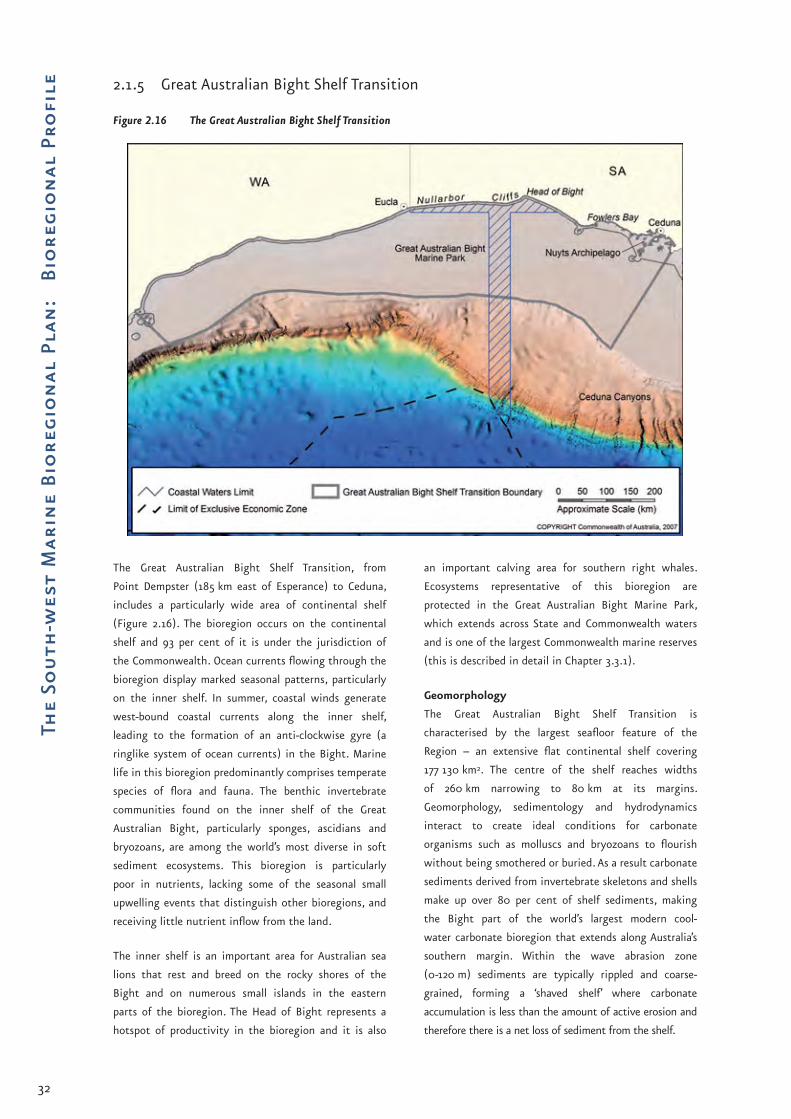
32
The
Sou
th-w
est
Mar
ine
Bio
regi
on
al P
lan
: B
iore
gio
nal
Pro
file 2.1.5 Great Australian Bight Shelf Transition
Figure 2.16 The Great Australian Bight Shelf Transition
The Great Australian Bight Shelf Transition, from
Point Dempster (185 km east of Esperance) to Ceduna,
includes a particularly wide area of continental shelf
(Figure 2.16). The bioregion occurs on the continental
shelf and 93 per cent of it is under the jurisdiction of
the Commonwealth. Ocean currents flowing through the
bioregion display marked seasonal patterns, particularly
on the inner shelf. In summer, coastal winds generate
west-bound coastal currents along the inner shelf,
leading to the formation of an anti-clockwise gyre (a
ringlike system of ocean currents) in the Bight. Marine
life in this bioregion predominantly comprises temperate
species of flora and fauna. The benthic invertebrate
communities found on the inner shelf of the Great
Australian Bight, particularly sponges, ascidians and
bryozoans, are among the world’s most diverse in soft
sediment ecosystems. This bioregion is particularly
poor in nutrients, lacking some of the seasonal small
upwelling events that distinguish other bioregions, and
receiving little nutrient inflow from the land.
The inner shelf is an important area for Australian sea
lions that rest and breed on the rocky shores of the
Bight and on numerous small islands in the eastern
parts of the bioregion. The Head of Bight represents a
hotspot of productivity in the bioregion and it is also
an important calving area for southern right whales.
Ecosystems representative of this bioregion are
protected in the Great Australian Bight Marine Park,
which extends across State and Commonwealth waters
and is one of the largest Commonwealth marine reserves
(this is described in detail in Chapter 3.3.1).
Geomorphology
The Great Australian Bight Shelf Transition is
characterised by the largest seafloor feature of the
Region – an extensive flat continental shelf covering
177 130 km2. The centre of the shelf reaches widths
of 260 km narrowing to 80 km at its margins.
Geomorphology, sedimentology and hydrodynamics
interact to create ideal conditions for carbonate
organisms such as molluscs and bryozoans to flourish
without being smothered or buried. As a result carbonate
sediments derived from invertebrate skeletons and shells
make up over 80 per cent of shelf sediments, making
the Bight part of the world’s largest modern cool-
water carbonate bioregion that extends along Australia’s
southern margin. Within the wave abrasion zone
(0-120 m) sediments are typically rippled and coarse-
grained, forming a ‘shaved shelf’ where carbonate
accumulation is less than the amount of active erosion and
therefore there is a net loss of sediment from the shelf.

33
The Marine Environment
Oceanography
The system of ocean currents in this bioregion is
complex, reflecting marked seasonal variation in wind
patterns and in water density. Changes in water density
are caused by fluctuations in temperature and salinity.
During winter, water moves east through the bioregion,
fuelled by wind-driven coastal currents on the inner shelf
and by the Leeuwin Current on the shelf break. During
summer, the strength of the Leeuwin Current weakens
to the point where it is largely absent while coastal
winds generate west-bound coastal currents along the
inner shelf, leading to the formation of an anti-clockwise
circulation gyre in the Bight. Swells are predominantly
from the south-west, so the eastern Bight coastline is
subject to higher wave energies, as the concave shape of
the coastline affords some protection to western parts
of the Bight.
Biological communities
Marine life in this bioregion comprises temperate
species that are found throughout the continental shelf
of south-eastern Australia. Some species characteristic
of warm Indo-Pacific waters occur here, particularly
plankton, fish, echinoderm and hydroid species. This
is probably the result of seasonal fluxes of warm
water transported by the Leeuwin Current. Within the
bioregion, infauna (animals living within the sediments
of the seabed) are likely to make up a large proportion
of the overall biomass. The ecological importance of the
infauna is reflected in the catch of the Great Australian
Bight Trawl Fishery and mainly comprises latchet
(incidental catch) and deep-water flathead (targeted
catch). Latchet feed directly on large infaunal species,
while deep-water flathead ambush smaller species that
forage on the bottom for infauna. The infauna appears
to be rich and diverse – probably reflecting the diversity
in sediment types and the broad gradients of exposure
and depth. Benthic invertebrate communities inhabiting
the east shelf of the Great Australian Bight, particularly
the inner shelf, have been identified as one of the
world’s most diverse soft sediment ecosystems (798
species have been identified so far, including 360 species
of sponges, 138 ascidians and 93 bryozoans). The species
that make up these communities tend to vary from the
inner to the outer shelf, and also decrease in abundance
moving away from the coast. On the inner shelf of
the more eastern parts of this bioregion, marine plant
communities are more diverse, particularly in the lee of
islands in the Nuyts Archipelago, where significant beds
of seagrass are found.
Australian sea lions forage on benthic communities
throughout the bioregion and have established breeding
colonies at Nuyts Reef and at numerous points along
the base of the Bunda Cliffs. The Head of Bight is an
important aggregation site for southern right whales
and their calves, which migrate annually through the
Region during autumn and winter. Juvenile southern
bluefin tuna inhabit the area between December and
April to predate on small pelagic fish, squid, krill and
salps. The Great Australian Bight is the only area in the
world where young southern bluefin tuna (1-5 year old
fish) are known to surface consistently. Small pelagic
fish including sardine, scaly mackerel, jack mackerel,
yellow tail, blue mackerel, anchovy, blue sprat and sandy
sprat are considered an important trophic link between
plankton communities and larger fish-eating predators,
such as sharks, bluefin tuna and seabirds (Figure 2.14).
Southern reef squid. Photo: Marine Life Society of South Australia.

34
The
Sou
th-w
est
Mar
ine
Bio
regi
on
al P
lan
: B
iore
gio
nal
Pro
file Ecosystem processes
This bioregion is particularly nutrient-poor, lacking
some of the seasonally predictable small upwelling
events that occur in neighbouring bioregions. Biological
productivity in this bioregion is driven mainly through
pulses of mixed water that irregularly wash through the
system from the west. Anecdotal evidence from fi shers,
who track aggregations of school shark through this
system, describes pulses of ‘dirty water’, soon followed by
increased availability of baitfi sh and subsequently squid
and, later still, larger predators. Highly mobile, higher
order predators (such as tuna, school and whaler sharks,
dolphins and seabirds) that normally forage in other
systems, appear to track the food chains associated with
these pulses of productivity as they move through the
bioregion. These productivity pulses are highly variable
within and between years.
An ecologically important hotspot of productivity occurs
on the inner shelf at the Head of Bight. Satellite images
show higher concentrations of chlorophyll in this area,
and this is supported by anecdotal observations of
higher concentrations of a number of species, which
appear to use the relatively sheltered area of mixed
seagrass, sand and limestone reef as nursery and feeding
grounds. These include juvenile Australian salmon,
mulloway, King George whiting, school shark, sea lions
(Figure 2.17), dolphins and southern right whales.
Studies on benthic invertebrates also found the highest
values of biomass and species richness at the Head of
Bight.
Figure 2.17 Simplifi ed diagram of the predators and prey of the Australian sea lion

35
The Marine Environment
Table 2.5 Key ecological features and other important areas of the Great Australian Bight Shelf Transition
Feature or area Rationale
Great Australian Bight Marine Park
Protected place (see Chapter 3.3).
Israelite Bay and coastal waters to the east
Important area for protected species (see Appendix D):Southern right whale (calving).•
Eastern part of the Great Australian Bight
Important area for protected species (see Appendix D):Orange roughy (aggregations).•
Inshore waters of the Great Australian Bight
Commonwealth waters adjacent to the Head of Bight are a regional key ecological feature (see Chapter 3.1) – these waters support enhanced productivity and high species biodiversity. They also provide important feeding and resting aggregation areas for marine life.Important areas for protected species (see Appendix D):
White shark (nursery area and feeding area);Southern right whale (calving area); andAustralian sea lion (breeding colony).
•••
Nuyts Archipelago Important area for protected species(see Appendix D):White shark (feeding area);Caspian tern, flesh-footed shearwater, short-tailed shearwater (rookeries); andAustralian sea lion (breeding colony).
•••
Twilight Cove Important area for protected species (see Appendix D):Southern right whale (calving).•
Fowlers Bay Important area for protected species (see Appendix D):White shark (feeding area);Australian sea lion (breeding colony); andSouthern right whale (calving).
•••
Small pelagic fish Key ecological feature (see Chapter 3.1) – important trophic link between plankton communities and larger marine predators.
Benthic invertebrate communities of the eastern Great Australian Bight
Key ecological feature (see Chapter 3.1) – high species biodiversity.
Flesh-footed shearwater. Photo: Ian Hutton, Department of the Environment, Water, Heritage and the Arts.

36
The
Sou
th-w
est
Mar
ine
Bio
regi
on
al P
lan
: B
iore
gio
nal
Pro
file 2.1.6 Spencer Gulf Shelf Province
Figure 2.18 Spencer Gulf Shelf Province
The Spencer Gulf Shelf Province extends over the
continental shelf between Ceduna and Cape Jaffa
(Figure 2.18). The bioregion straddles the South-
east and the South-west Marine Regions. Thirty-nine
per cent of the bioregion is under the jurisdiction of
the Commonwealth, within the South-west Marine
Region. The bioregion is represented in the National
Representative System of MPAs through the Murray
Commonwealth Marine Reserve, which is part of the
South-east Network of Commonwealth Marine Reserves.
A complex coastline of gulfs, peninsulas and islands
characterise the bioregion (note – waters in the gulfs
inside Kangaroo Island occur in State waters). Ocean
currents flowing through the bioregion display marked
seasonal patterns, particularly on the inner shelf where
coastal winds generate west-bound coastal currents
in summer. In autumn, a density current known as
‘Bonaparte’s Tongue’ flows out from the Spencer Gulf and
over the edge of the continental shelf.
Marine life in this bioregion comprises a mix of warm
and cold temperate species, including New Zealand fur
seals, Australian sea lions, little penguins and pygmy
blue whales. The bioregion also features a number of
local upwellings of nutrient-rich water south-west
of Kangaroo Island and south and west of the Eyre
Peninsula, between December and April. During summer,
pygmy blue whales feed on krill aggregations associated
with a small upwelling west of Kangaroo Island, known
as the ‘Kangaroo Island Pool’ – a hotspot for marine
productivity. Spawning aggregations of a number of
commercially fished species are found in this area. The
shield islands, characteristic of the bioregion, provide
shelter for marine life and are associated with highly
diverse benthic communities and are used by sharks as
pupping grounds.
Geomorphology
The bioregion has a complex coastline featuring the Eyre
Peninsula, Spencer Gulf, Gulf St Vincent and Kangaroo
Island. The gulfs are shallow bodies of water with depths
less than 50 m in Spencer Gulf and 41 m in Investigator
Strait and Gulf St Vincent. A bedrock ridge at 50 m depth
marks the entrance to the Spencer Gulf and numerous
islands rise from the ridge forming a partial barrier that
isolates the gulf waters from the open ocean. The cool-
water carbonate shelf described in Chapter 2.1.5 (Great
Australian Bight Shelf Transition) also extends into this
bioregion. The inner shelf is characterised by numerous
shield islands – so called because of their shielding
effect on the coast – the largest of these being Kangaroo

37
The Marine Environment
Island. These islands are scattered between Cape Spencer
and the western boundary of the bioregion.
Oceanography
The ocean currents operating in this bioregion display
similar characteristics to the Great Australian Bight Shelf
Transition – during winter, water moves east through
the bioregion, fuelled by wind-driven coastal currents on
the inner shelf and by the Leeuwin Current on the shelf
break. During summer, the Leeuwin Current weakens
and coastal winds generate west-bound coastal currents
along the inner shelf. West of the Eyre Peninsula and
Kangaroo Island, local upwellings of nutrient-rich water
create several predictable hotspots of productivity
in an otherwise nutrient-poor environment. In the
western limits of the bioregion, downwelling of waters
from the inner shelf to the outer shelf and shelf break
occurs during winter. The relatively shallow gulf
waters are cooler than the continental shelf waters in
winter (~12oC) and warmer in summer (~24oC), due to
restricted mixing across the mouths of the gulfs. Sea
surface temperature frontal systems have been observed
at the mouths of the Spencer Gulf and Investigator
Strait during summer months, with frontal temperature
differences of 3-4oC in surface waters and 7-8oC in
bottom waters. As the Spencer Gulf surface waters cool
during the autumn, the high salinity water residing at
the head of the Gulf becomes dense enough to form the
outgoing bottom density current known as Bonaparte’s
Tongue. This tongue of dense, salty water, around 20 km
wide and 20 m thick, flows out of the mouth of the Gulf
and across the Lincoln Shelf for over 100 km, eventually
falling over the edge of the shelf to depths of about
250 m (Figure 2.19). The outflow of dense water occurs
in regular pulses over a period of approximately three
months.
Figure 2.19 Bathymetry of Spencer Gulf and Gulf St Vincent showing outflow of Bonaparte’s Tongue
Geoscience Australia

38
The
Sou
th-w
est
Mar
ine
Bio
regi
on
al P
lan
: B
iore
gio
nal
Pro
file Biological communities
Marine life in this bioregion is typical of a transition
from warm to cold temperate waters, where cool
temperate species of demersal fish from Bass Strait
and Tasmania coexist with many demersal fish species
characteristic of the Southwest Shelf Province. The
eastern part of the bioregion appears to host a relatively
different group of predators to those found in the Great
Australian Bight Shelf Transition. This is possibly because
of the higher biological productivity in this part of the
Region. New Zealand fur seals (mostly feeding in pelagic
habitats around the shelf break), Australian sea lions
(mainly feeding in benthic habitats on the continental
shelf), dolphins, penguins, blue whales and seabirds, such
as shearwaters and albatross, have all been observed
in this area. Small pelagic fish including sardine, scaly
mackerel, jack mackerel, yellow tail, blue mackerel,
anchovy, blue sprat and sandy sprat, are considered an
important trophic link between plankton communities
and larger fish-eating predators, such as New Zealand fur
seals, sharks including bronze whalers and hammerheads,
and predatory fish, like Australian salmon and barracouta
(Figure 2.14). The salty warmer waters of the gulfs
support unique benthic habitats, including one of the
largest temperate seagrass ecosystems on earth.
The waters around the ‘shield islands’ support highly
diverse benthic communities and aggregations of krill
and salps. The islands also provide protection for shark
pupping grounds, extensive seagrass beds to depths of
50 m, and sponge-dominated communities around the
island below 50 m depth. This is an important area for
Australian sea lions and New Zealand fur seals that
haul out on the numerous islands in the area. In pelagic
habitats, multiple patches of phytoplankton occur
throughout the bioregion, while zooplankton appears
to be largely confined to one large patch at the Spencer
Gulf entrance.
Ecosystem processes
A distinguishing and ecologically important feature of
this bioregion is the existence of seasonally predictable
upwellings of nutrient-rich water between December
and April, that enhance productivity and attract feeding
aggregations. The main areas of surface upwelling are
the Kangaroo Island Pool, south-west of Kangaroo Island
along the 100 m depth contour and south and west of
the Eyre Peninsula. Although the exact causes of the
upwellings and where and when they occur are not
clearly understood, it is likely that they are the result of
interactions between wind, ocean currents and abrupt
changes in the seafloor features, such as at the shelf
break and near submarine canyons. These upwellings
may also be connected to infiltration of ground water
known to occur on the middle shelf in this system.
Table 2.6 Key ecological features and other important areas of the Spencer Gulf Shelf Province
Feature or area Rationale
Murray Commonwealth Marine Reserve(in South-east Marine Region)
Protected place.
Yorke Peninsula Important area for protected species (see Appendix D):White-bellied sea eagle (nesting).•
Great Althorpe Island Important area for protected species (see Appendix D):Short-tailed shearwater (rookery).•
Gambier Island Important area for protected species (see Appendix D):Short-tailed shearwater (rookery).•
Lewis, Hopkins and Williams Islands (Cape Catastrophe area, Southern Eyre Peninsula)
Important area for protected species (see Appendix D):Short-tailed shearwater (rookeries).•
Greenly Island Important area for protected species (see Appendix D):Short-tailed shearwater (rookery).•

39
The Marine Environment
Feature or area Rationale
Eyre Peninsula Important area for protected species(see Appendix D):Osprey and white-bellied sea eagle (nesting area).•
Eyre Island and Little Eyre Island
Important area for protected species (see Appendix D):Caspian tern (rookeries).•
Investigator Group Important area for protected species (see Appendix D):Short-tailed shearwater (rookeries).•
West Waldegrave Island Important area for protected species (see Appendix D):White shark (feeding area); andAustralian sea lion (breeding colony). One of the five known Australian sea lion breeding areas that produce more than 100 pups a year.
••
Kangaroo Island Important area for protected species (see Appendix D):White shark (feeding area). There is a large New Zealand fur seal colony on Kangaroo Island, providing food for white sharks;Osprey (nesting area); and Australian sea lion (breeding colony – Seal Bay). One of the five known Australian sea lion breeding areas that produce more than 100 pups a year.
•
••
Kangaroo Island Pool and Eyre Peninsula upwellings
Key ecological feature (see Chapter 3.1) – upwellings enhance marine productivity and attract feeding aggregations.
Spencer Gulf and the Gulf of St Vincent (including Sir Joseph Banks Group, Dangerous Reef and West Troubridge Shoal)
Important area for protected species (see Appendix D):White shark (feeding area). These gulfs are considered important feeding grounds for sub-adult white sharks, although juvenile and large adult sharks have also been observed in these areas. The abundance of dolphins, finfish and other elasmobranchs are presumably targeted by white sharks occurring in these gulfs;Caspian tern (rookeries – West Troubridge Shoal and Sir Joseph Banks Group); andAustralian sea lion (breeding colony – Dangerous Reef). One of the five known Australian sea lion breeding areas that produce more than 100 pups a year.
•
••
Olive Island Important area for protected species (see Appendix D):Australian sea lion (breeding colony). One of the five known Australian sea lion breeding areas that produce more than 100 pups a year; andWhite shark (feeding area).
•
•
Liguanea Island Important area for protected species (see Appendix D):White shark (feeding area). There is a large New Zealand fur seal colony on Liguanea Island, providing food for white sharks.
•
Neptune Islands Important area for protected species (see Appendix D):White shark (feeding area). Large New Zealand fur seal colony provides food for white sharks.
•
Small pelagic fish Key ecological feature (see Chapter 3.1) – important trophic link between plankton communities and larger marine predators.

40
The
Sou
th-w
est
Mar
ine
Bio
regi
on
al P
lan
: B
iore
gio
nal
Pro
file 2.1.7 Southern Province
Figure 2.20 The Southern Province
This is the largest bioregion in Australia’s waters and
includes the deepest ocean areas of the Australian EEZ
– reaching depths of around 5900 m. The bioregion
extends from the shelf break south of Kangaroo
Island to the southern edge of the Naturaliste Plateau
(Figure 2.20). The Southern Province is entirely under
Commonwealth jurisdiction, straddling the South-east
and the South-west Marine Regions. Eighty-five per cent
of the bioregion occurs within the South-west Marine
Region. It is characterised by a long continental slope
incised by numerous, well-developed submarine canyons,
two extensive mid-slope terraces (the Ceduna and Eyre
Terraces) and the Diamantina Fracture Zone, a rugged
area of deep seafloor comprising numerous ridges and
troughs.
The demersal fish assemblages inhabiting the shelf
break and slope resemble those found on the South-
east Marine Region’s continental slope more than those
of the Central Western Province. The canyons south
of Kangaroo Island and adjacent shelf break appear
to be important areas for biological productivity and
for spawning and aggregation for a range of marine
species, particularly during winter. The Albany Group of
submarine canyons south of Albany and Esperance are
also considered important for biological productivity
that attracts feeding aggregations. A representative
transect of the benthic environment of this bioregion
has been captured in the Benthic Protection Zone of
the Great Australian Bight Marine Park, which extends
offshore to the limit of the EEZ.
Geomorphology
The seafloor of the Southern Province is characterised
by a long continental slope incised by numerous,
well-developed submarine canyons. Although most
of the slope is marked by canyons, the Albany Group
(Figure 2.21) in the east and the canyons south of the
Eyre Peninsula are the most dramatic, cutting deeply
into areas of steep slope. Two extensive mid-slope
terraces, the Ceduna and Eyre Terraces, collectively
covering an area of 147 150 km2, are also distinctive to
the bioregion. The terraces are intersected by numerous
canyons and gullies, which are broader and more widely
spaced than the Albany Canyons. The Ceduna Terrace
(200-3000 m water depth) is the most extensive,
being about 700 km long and reaching 200 km in
width. The Eyre Terrace (200-1600 m water depth) is
smaller and narrower, reaching a maximum width of
70 km. A vast area of abyssal plain (200 651 km2) gives
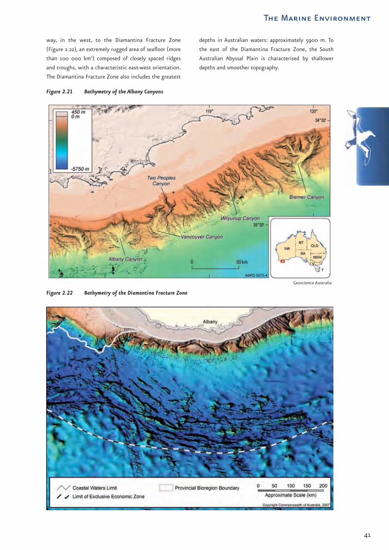
41
The Marine Environment
way, in the west, to the Diamantina Fracture Zone
(Figure 2.22), an extremely rugged area of seafloor (more
than 100 000 km2) composed of closely spaced ridges
and troughs, with a characteristic east-west orientation.
The Diamantina Fracture Zone also includes the greatest
depths in Australian waters: approximately 5900 m. To
the east of the Diamantina Fracture Zone, the South
Australian Abyssal Plain is characterised by shallower
depths and smoother topography.
Figure 2.21 Bathymetry of the Albany Canyons
Figure 2.22 Bathymetry of the Diamantina Fracture Zone
Geoscience Australia

42
The
Sou
th-w
est
Mar
ine
Bio
regi
on
al P
lan
: B
iore
gio
nal
Pro
file Oceanography
The Leeuwin Current transports warm, nutrient-poor
water eastward along the shelf break and upper slope.
Meso-scale eddies form from the Leeuwin Current south
of Albany, Esperance and the Eyre Peninsula, where
coastal topography changes direction. Eddies also drift
westward from south of Victoria and first encounter
the slope south of the Recherche Archipelago. Here
they take on warm water from the Leeuwin Current
and strengthen, continuing their movement westward
for up to 18 months. Beneath the Leeuwin Current the
cooler waters of the Flinders Current, which has its
core at approximately 600 m depth, appear to provide
a deep westward conveyor belt for the Region’s fauna.
The strength and behaviour of the Flinders Current
appears to be affected by wind and the density of the
water bodies on the shelf, and at times may vanish
or even reverse direction. The bioregion has areas
of seasonal upwelling and downwelling along the
continental slope. Downwelling from the shelf to
the slope occurs in the western half of the Bight in
summer, effectively suppressing upwelling in this area.
South-west of Kangaroo Island and south of the Eyre
Peninsula, currents, winds and topography interact to
produce upwellings of nutrient-rich water from the slope
onto the shelf. Local upwellings are also known to occur
on the slope south of Esperance and Albany, onto the
adjacent shelf area.
Biological communities
The demersal fish assemblages of the shelf break and
slope of this bioregion are more like those on the slope
of the South-east Marine Region than those of the
Central Western Province. Scientists have described
463 species of fish on the slope of this bioregion, of
which 26 are endemic. Only one extensive study of
slope fish communities, undertaken during the late
1980s, has been conducted in this bioregion. There is
a lower proportion of bottom-feeding demersal fish in
this bioregion compared with the west coast, which
appears to relate to greater availability of food such as
meso-pelagic fish like myctophids (lantern fish) in the
water column. Commercial fish landings taken from
the shelf break and down the upper and mid-slope
include orange roughy, blue grenadier, Bight redfish,
school shark, gummy shark, angel shark, gemfish, deep
water flatheads, leatherjackets, latchets, stingrays and
stingarees. These fish are preyed on by deep-diving
toothed whales and dolphins, including sperm whales
and killer whales, seabirds, tunas and other large
predatory fish. Blue whales, southern right whales and
humpback whales also occur in this bioregion.
Ecosystem processes
The canyons and adjacent shelf break south of Kangaroo
Island receive upwellings of nutrient-rich water.
Anecdotal evidence indicates the canyons may also
be an important spawning and aggregation area for
a range of marine species, particularly during winter.
Commercially fished species including blue grenadier,
warehou, orange roughy and western gemfish may
aggregate here to spawn (note that for orange roughy,
no spawning aggregation has yet been found but a high
density of eggs has been observed, pointing to a likely
spawning aggregation in the area). Anecdotal accounts
from fishers indicate the area is also used as a mating
ground for school shark. Archival tags placed on school
shark showed that they spent a considerable proportion
of their time foraging around the canyon system. There
are highly productive giant crab and lobster grounds
along the shelf edge. It is to be expected that the
water column above the canyons and shelf break is also
an important foraging ground for large predators like
sharks, cetaceans and New Zealand fur seals.
The Albany Group of submarine canyons – approximately
32 canyons encompassing 700 km of continental slope
from longitude 115oE to 124oE – is considered an area of
enhanced biological productivity. Small but significant
numbers of school and gummy shark are caught along
the shelf break, outside the Recherche Archipelago.
Deep-water fishers sporadically fish a cluster of orange
roughy aggregations along the mid-slope in the same
area. Fisheries scientists and some fishers speculate that
species such as blue grenadier and western gemfish may
have spawning aggregations amongst the submarine
canyons and other prominent geological features rising
from the seafloor on the slope adjacent to Esperance
and Hopetoun.
The Diamantina Fracture Zone represents a unique but
virtually unknown region of deep-sea habitat and experts
speculate it is highly likely that marine communities in
this area comprise unique species with high biodiversity.
The physical complexity of numerous troughs and ridges
and complex water circulation that occurs in this area
support these assertions.
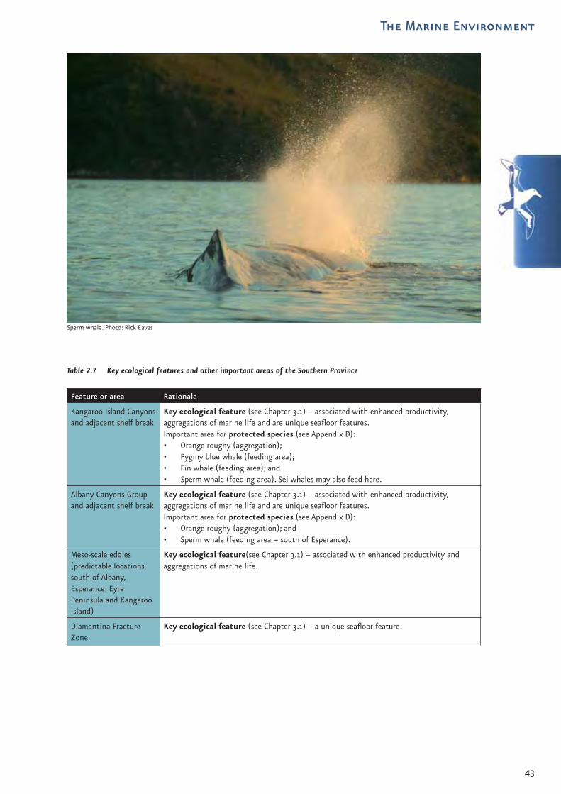
43
The Marine Environment
Table 2.7 Key ecological features and other important areas of the Southern Province
Feature or area Rationale
Kangaroo Island Canyons and adjacent shelf break
Key ecological feature (see Chapter 3.1) – associated with enhanced productivity, aggregations of marine life and are unique seafloor features.Important area for protected species (see Appendix D):
Orange roughy (aggregation);Pygmy blue whale (feeding area);Fin whale (feeding area); andSperm whale (feeding area). Sei whales may also feed here.
••••
Albany Canyons Group and adjacent shelf break
Key ecological feature (see Chapter 3.1) – associated with enhanced productivity, aggregations of marine life and are unique seafloor features.Important area for protected species (see Appendix D):
Orange roughy (aggregation); andSperm whale (feeding area – south of Esperance).
••
Meso-scale eddies(predictable locations south of Albany, Esperance, Eyre Peninsula and Kangaroo Island)
Key ecological feature(see Chapter 3.1) – associated with enhanced productivity and aggregations of marine life.
Diamantina Fracture Zone
Key ecological feature (see Chapter 3.1) – a unique seafloor feature.
Sperm whale. Photo: Rick Eaves

44
The
Sou
th-w
est
Mar
ine
Bio
regi
on
al P
lan
: B
iore
gio
nal
Pro
file Key references and further
readings
Department of the Environment and Heritage (DEH),
2005, Great Australian Bight Marine Park (Commonwealth
Waters) Management Plan 2005–2012, DEH, Canberra,
<www.environment.gov.au/coasts/mpa>, accessed
07/05/07.
Department of the Environment and Heritage (DEH),
2006, A Guide to the Integrated Marine and Coastal
Regionalisation of Australia Version 4.0, DEH, Canberra,
<www.environment.gov.au/coasts/mbp/publications/
imcra-4>, accessed 07/05/07.
Department of the Environment and Water Resources
(DEW), 2006, Characterisation of the Marine Environment of
the South-west Marine Region: Perth Workshop Report, DEW,
Canberra, <www.environment.gov.au/coasts/mbp/
south-west>.
MacLeod, C.D., & Mitchell, G., 2006, Key Areas for Beaked
Whales Worldwide, Journal of Cetacean Research 17, Part 3,
p.18.
McClatchie, S., Middleton, J., Pattiaratchi, C., Currie,
D., & Kendrick, G. (eds), 2006, The South-west Marine
Region: Ecosystems and Key Species Groups, Department
of the Environment & Water Resources, Canberra
<www.environment.gov.au/coasts/mbp/south-west>.
Potter, A., Southby, C., & Heap A.D., 2006,
Geomorphology and Sedimentology of the South Western
Planning Area of Australia, Geoscience Australia, Canberra,
<www.environment.gov.au/coasts/mbp/south-west>.
Legislation
Available from <www.legislation.sa.gov.au>
Fisheries Act 1982 (SA).
National Parks and Wildlife Act 1972 (SA).
Map data
Figure 2.5 Bioregions of the South-west Marine RegionDepartment of the Environment, Water, Heritage and the Arts (2006): Commonwealth Marine Planning RegionsDepartment of the Environment, Water, Heritage and the Arts (2006):Integrated Marine and Coastal Regionalisation of Australia v4.0 - Provincial BioregionsGeoscience Australia (1998): Australia, TOPO-2.5M Topographic Data, Drainage and RoadsGeoscience Australia (2004): Gazetteer of AustraliaGeoscience Australia (2005): Australian Bathymetry and Topography
Geoscience Australia (2006): Australian Maritime Boundaries (AMB) v2.0Projection: Geographics, Datum: GDA94Produced by the Environmental Resources Information Network (ERIN) Australian Government Department of the Environment, Water, Heritage and the Arts. COPYRIGHT Commonwealth of Australia, 2007.
Figure 2.6 The Southwest Shelf TransitionDepartment of the Environment, Water, Heritage and the Arts (2003): Historic Shipwrecks RegisterDepartment of the Environment, Water, Heritage and the Arts (2006): Commonwealth Marine Planning RegionsDepartment of the Environment, Water, Heritage and the Arts (2006):Integrated Marine and Coastal Regionalisation of Australia v4.0 - Provincial BioregionsGeoscience Australia (1998): Australia, TOPO-2.5M Topographic DataGeoscience Australia (2004): Gazetteer of AustraliaGeoscience Australia (2005): Australian Bathymetry and TopographyGeoscience Australia (2006): Australian Maritime Boundaries (AMB) v2.0Projection: Geographics, Datum: GDA94Produced by the Environmental Resources Information Network (ERIN) Australian Government Department of the Environment, Water, Heritage and the Arts. COPYRIGHT Commonwealth of Australia, 2007.
Figure 2.10 The Central Western ProvinceDepartment of the Environment, Water, Heritage and the Arts (2006): Commonwealth Marine Planning RegionsDepartment of the Environment, Water, Heritage and the Arts (2006):Integrated Marine and Coastal Regionalisation of Australia v4.0 - Provincial BioregionsGeoscience Australia (1998): Australia, TOPO-2.5M Topographic DataGeoscience Australia (2004): Gazetteer of AustraliaGeoscience Australia (2005): Australian Bathymetry and TopographyGeoscience Australia (2006): Australian Maritime Boundaries (AMB) v2.0Projection: Geographics, Datum: GDA94Produced by the Environmental Resources Information Network (ERIN) Australian Government Department of the Environment, Water, Heritage and the Arts. COPYRIGHT Commonwealth of Australia, 2007.
Figure 2.13 The Southwest Shelf ProvinceDepartment of the Environment, Water, Heritage and the Arts (2004):Collaborative Australian Protected Areas Database - CAPADDepartment of the Environment, Water, Heritage and the Arts (2006):Integrated Marine and Coastal Regionalisation of Australia v4.0 - Provincial BioregionsGeoscience Australia (1998): Australia, TOPO-2.5M Topographic DataGeoscience Australia (2004): Gazetteer of AustraliaGeoscience Australia (2005): Australian Bathymetry and TopographyGeoscience Australia (2006): Australian Maritime Boundaries (AMB) v2.0Projection: Geographics, Datum: GDA94Produced by the Environmental Resources Information Network (ERIN) Australian Government Department of the Environment, Water, Heritage and the Arts. COPYRIGHT Commonwealth of Australia, 2007.
Figure 2.15 The Southwest TransitionDepartment of the Environment, Water, Heritage and the Arts (2006):Integrated Marine and Coastal Regionalisation of Australia v4.0 - Provincial BioregionsGeoscience Australia (1998): Australia, TOPO-2.5M Topographic DataGeoscience Australia (2004): Gazetteer of AustraliaGeoscience Australia (2005): Australian Bathymetry and TopographyGeoscience Australia (2006): Australian Maritime Boundaries (AMB) v2.0Projection: Geographics, Datum: GDA94Produced by the Environmental Resources Information Network (ERIN) Australian Government Department of the Environment, Water, Heritage and the Arts. COPYRIGHT Commonwealth of Australia, 2007.

45
The Marine Environment
Figure 2.16 The Great Australian Bight Shelf TransitionDepartment of the Environment, Water, Heritage and the Arts (2004):Collaborative Australian Protected Areas Database - CAPADDepartment of the Environment, Water, Heritage and the Arts (2006):Integrated Marine and Coastal Regionalisation of Australia v4.0 - Provincial BioregionsGeoscience Australia (1998): Australia, TOPO-2.5M Topographic DataGeoscience Australia (2004): Gazetteer of AustraliaGeoscience Australia (2005): Australian Bathymetry and TopographyGeoscience Australia (2006): Australian Maritime Boundaries (AMB) v2.0Projection: Geographics, Datum: GDA94Produced by the Environmental Resources Information Network (ERIN) Australian Government Department of the Environment, Water, Heritage and the Arts. COPYRIGHT Commonwealth of Australia, 2007.
Figure 2.18 The Spencer Gulf Shelf ProvinceDepartment of the Environment, Water, Heritage and the Arts (2003): Historic Shipwrecks RegisterDepartment of the Environment, Water, Heritage and the Arts (2006):Commonwealth Marine Planning RegionsDepartment of the Environment, Water, Heritage and the Arts (2006):Integrated Marine and Coastal Regionalisation of Australia v4.0 - Provincial BioregionsGeoscience Australia (1998): Australia, TOPO-2.5M Topographic DataGeoscience Australia (2004): Gazetteer of AustraliaGeoscience Australia (2005): Australian Bathymetry and TopographyGeoscience Australia (2006): Australian Maritime Boundaries (AMB) v2.0Projection: Geographics, Datum: GDA94Produced by the Environmental Resources Information Network (ERIN) Australian Government Department of the Environment, Water, Heritage and the Arts. COPYRIGHT Commonwealth of Australia, 2007.
Figure 2.20 The Southern ProvinceDepartment of the Environment, Water, Heritage and the Arts (2004):Collaborative Australian Protected Areas Database - CAPADDepartment of the Environment, Water, Heritage and the Arts (2006): Commonwealth Marine Planning RegionsDepartment of the Environment, Water, Heritage and the Arts (2006):Integrated Marine and Coastal Regionalisation of Australia v4.0 - Provincial BioregionsGeoscience Australia (1998): Australia, TOPO-2.5M Topographic DataGeoscience Australia (2004): Gazetteer of AustraliaGeoscience Australia (2005): Australian Bathymetry and TopographyGeoscience Australia (2006): Australian Maritime Boundaries (AMB) v2.0Projection: Geographics, Datum: GDA94Produced by the Environmental Resources Information Network (ERIN) Australian Government Department of the Environment, Water, Heritage and the Arts. COPYRIGHT Commonwealth of Australia, 2007.
Figure 2.22 Bathymetry of the Diamantina Fracture ZoneDepartment of the Environment, Water, Heritage and the Arts (2006):Integrated Marine and Coastal Regionalisation of Australia v4.0 - Provincial BioregionsGeoscience Australia (1998): Australia, TOPO-2.5M Topographic DataGeoscience Australia (2004): Gazetteer of AustraliaGeoscience Australia (2005): Australian Bathymetry and TopographyGeoscience Australia (2006): Australian Maritime Boundaries (AMB) v2.0Projection: Geographics, Datum: GDA94Produced by the Environmental Resources Information Network (ERIN) Australian Government Department of the Environment, Water, Heritage and the Arts. COPYRIGHT Commonwealth of Australia, 2007.

46A fl y-trap anemone attached to an octocoral on steep rocky bottom. Central Western Province, 489 m deep. Photo: CSIRO.

47
Conservation Values
Chapter 3 Conservation Values of the South-west Marine Region
Marine Bioregional Plans will identify those components
of marine biodiversity and heritage that are recognised
as conservation values by the Australian Government.
Knowing what the conservation values are for each
Region will help in making decisions about proposed
developments and other ongoing activities.
For the purpose of marine bioregional planning,
conservation values are defined as those elements of
the Region that are either specifically protected under
the Environment Protection and Biodiversity Conservation
Act 1999 (EPBC Act) or the Historic Shipwrecks Act 1976,
or have been identified through the planning process
as key ecological features in the Commonwealth
marine environment. Key ecological features are not
specifically protected under the EPBC Act, although the
marine environment as a whole is a matter of National
Environmental Significance under the EPBC Act. Key
ecological features are being identified as conservation
values within Commonwealth waters to help inform
decisions about the marine environment in any given
Marine Region.
Matters specifically protected under Part 13 and Part
15 of the EPBC Act are recognised conservation values.
In the South-west Marine Region these include listed
threatened, migratory and marine species, cetaceans
(whales, dolphins and porpoises) and Commonwealth
marine reserves. Historic shipwrecks are also identified
as conservation values by virtue of their protection
under the Historic Shipwrecks Act 1976.
The marine conservation values identified in this
section will be the subject of assessment during the
development of the Draft South-west Marine Bioregional
Plan to:
understand the threats posed by current and
emerging activities;
determine priorities for mitigating threats; and
provide guidance for future decisions under the
EPBC Act on the potential significant impacts on
listed threatened and listed migratory species or
the Commonwealth marine environment of the
South-west Marine Region.
The nature and location of the conservation values
will also be considered in the establishment of
marine protected areas (MPAs) as part of the National
Representative System of MPAs (see Chapter 1). However,
conservation values will not automatically be included
in Commonwealth marine reserves. In accordance with
the Regional Specifications (Chapter 4.2), only those
marine conservation values for which spatial protection
is both desirable and appropriate will be considered in
developing the MPA network for the Region.
•
•
•
Southern right whale and calf. Photo: Clive McMahon, Australian Government Antarctic Division, Department of the Environment, Water, Heritage and the Arts.

48
The
Sou
th-w
est
Mar
ine
Bio
regi
on
al P
lan
: B
iore
gio
nal
Pro
file 3.1 Key ecological features of
the marine environment
Under the EPBC Act, the ‘marine environment’ of the
Commonwealth marine area is a matter of national
environmental significance (see Section 23 of the EPBC
Act). This means that any action that will have or is
likely to have a significant impact on the Commonwealth
marine environment must be referred to the Minister for
the Environment, Heritage and the Arts for assessment
and approval. National guidelines have been developed
to help in determining whether actions are likely
to have a significant impact, and can be found at
<www.environment.gov.au/epbc/policy>.
Marine Bioregional Plans will identify and describe key
ecological features of a Region’s marine environment.
Once Plans are finalised, key ecological features will
be considered in making decisions about whether
an action is likely to have a significant impact on the
Commonwealth marine environment.
For the purpose of marine bioregional planning, key
ecological features of the marine environment meet one
or more of the following criteria:
a species, group of species or a community with a
regionally important ecological role (e.g. a predator,
prey that affects a large biomass or number of
other marine species);
a species, group of species or a community that is
nationally or regionally important for biodiversity;
an area or habitat that is nationally or regionally
important for:
a) enhanced or high productivity (such as
predictable upwellings),
b) aggregations of marine life (such as feeding,
resting, breeding or nursery areas),
c) biodiversity and endemism; or
a unique seafloor feature with known or presumed
ecological properties of regional significance.
Key ecological features in the South-west Marine Region
are identified by the Australian Government on the basis
of advice from scientists about the ecological processes
and characteristics of the Region. An important source
of information used to identify key ecological features
in the Region was the South-west Marine Region Ecosystems
and Key Species Groups Report commissioned by the
Department of the Environment, Water, Heritage and the
•
•
•
•
Arts. A scientific workshop was conducted in September
2006, bringing together marine scientists with specific
experience and expertise in the Region. The workshop
explored what is currently known about the ecosystems
of the South-west Marine Region, and scientific
understanding of likely interactions and ecosystem
processes. The outcomes of the workshop and the
Ecosystems and Key Species Groups Report are available at
<www.environment.gov.au/coasts/mbp/south-west>.
Table 3.1 identifies key ecological features in the South-
west Marine Region determined during the development
of this Bioregional Profile, and summarises the rationale
used to identify a specific feature as a conservation
value in the Region (Chapter 2 provides further context
for understanding the role of different features in the
ecosystem). The collection of further and finer-scale
information during the next stage of the planning
process will improve our understanding of key ecological
features in the Region. This information will also be
used to confirm and refine the key ecological features
identified during the profiling stage of the process. This
information will underpin the analysis of the threats
that the marine environment may face over the next
10 to 20 years. The Draft South-west Marine Bioregional
Plan will include a refined list of key ecological features.
Seventeen key ecological features have been identified
so far within the South-west Marine Region. These
occur across 20 areas, and include one species and three
communities/species groups (Table 3.1). Figure 3.1
provides location details for areas identified in Table 3.1.
Sea pen. Photo: Marine Life Society of South Australia.

49
Conservation Values
Figu
re 3
.1
Key
ecol
ogic
al f
eatu
res
of t
he S
outh
-wes
t M
arin
e Re
gion
This
is a
lso
avai
labl
e as
a s
epar
ate
map
in t
he e
nvel
ope
in t
he b
ack
cove
r of
thi
s bo
ok.

50
The
Sou
th-w
est
Mar
ine
Bio
regi
on
al P
lan
: B
iore
gio
nal
Pro
file Table 3.1 Key ecological features of the South-west Marine Region
Key Ecological
Features
Bioregions
(IMCRA v.4.0) Rationale
1. West Coast Canyons and adjacent shelf break
Central Western Province, Southwest Transition
Enhanced productivity; feeding aggregations; unique seafloor featureThe West Coast Canyons are believed to be associated with small periodic upwellings that locally enhance productivity and attract aggregations of marine life. The Perth Canyon is prominent among these canyons because of its magnitude and ecological importance. The Perth Canyon marks the southern boundary for numerous tropical species groups on the shelf, including sponges, corals, decapods and xanthid crabs. Deep ocean currents upwelling in the canyon create a nutrient-rich cold-water habitat attracting feeding aggregations of deep diving mammals, such as pygmy blue whales and large predatory fish that feed on aggregations of small fish, krill and squid.
2. Diamantina Fracture Zone
Southern Province Unique seafloor featureThe Diamantina Fracture Zone is a rugged, deep-water environment composed of numerous closely spaced troughs and ridges covering more than 100 000 km2. Marine experts point out that the size and physical complexity of the Diamantina Fracture Zone suggest that it is likely to support deep-water communities characterised by high species diversity and endemism.
3. Albany Canyons Group and adjacent shelf break
Southern Province Enhanced productivity; feeding aggregations; unique seafloor featureThe Albany Canyons, including 32 canyons along 700 km of continental slope, are believed to be associated with small periodic upwellings that enhance productivity and attract aggregations of marine life. Anecdotal evidence indicates that this area supports fish aggregations that attract large predatory fish, sharks and toothed, deep-diving whales such as the sperm whale.
4. Kangaroo Island Canyons and adjacent shelf break
Southern Province Enhanced productivity; feeding and breeding aggregations; unique seafloor featureThe Kangaroo Island canyons – a small group of steep-sided, narrow canyons – are associated with enhanced productivity that attracts aggregations of marine life. Seasonal upwellings are believed to be an important factor enhancing production. These upwellings support aggregations of krill, small pelagic fish and squid that in turn attract marine mammals (e.g. pygmy blue whales, fin whales, sperm whales, dolphins and New Zealand fur seals), sharks, large predatory fish and seabirds. Anecdotal evidence indicates that orange roughy, blue grenadier and western gemfish aggregate and are thought to spawn in this area. Empirical evidence shows that orange roughy eggs occur in high densities. The canyons are also thought to be an important pupping area for school shark and the adjacent shelf break is known for high yields of giant crab and southern rock lobster.
5. Kangaroo Island Pool and Eyre Peninsula upwellings
Spencer Gulf Shelf Province
Enhanced productivity; feeding aggregationsThe Kangaroo Island Pool and Eyre Peninsula upwellings are known to be associated with seasonal aggregations of marine life. The nutrient-rich upwellings enhance the production of plankton communities supporting seasonal aggregations of krill, small pelagic fish and squid which in turn attract marine mammals (e.g. toothed whales, dolphins and New Zealand fur seals), sharks, large predatory fish and seabirds.

51
Conservation Values
Key Ecological
Features
Bioregions
(IMCRA v.4.0) Rationale
6. Meso-scale eddies (several locations)
Central Western Province,Southwest Transition,Southern Province
Enhanced productivity; feeding aggregationsEddies and eddy fields form at predictable locations off the western and south-western shelf break (south-west of Shark Bay, offshore of the Houtman Abrolhos Islands, south-west of Jurien Bay, Perth Canyon, south-west of Cape Leeuwin and south of Albany, Esperance and the Eyre Peninsula). The meso-scale eddies of this Region are important transporters of nutrients and plankton communities, taking them far offshore into the Indian Ocean where they are consumed by oceanic communities. Clockwise eddies are considered to play an important role in lifting deep water, which can be relatively cooler and richer in nutrients, toward the surface where it can enhance production of plankton communities that attract aggregations of marine life.
7. Naturaliste Plateau
Southwest Transition
Unique seafloor featureThe Naturaliste Plateau is a complex and isolated seafloor feature that occurs in an area where numerous water bodies and currents converge. It is also the only seafloor feature in the Region that interacts with the sub-tropical convergence front. Although there is very little known about the marine life of this part of the Region, experts point out that the combination of its structural complexity, mixed water dynamics and relative isolation is highly likely to support deep-water communities characterised by high species diversity and endemism.
8. Commonwealth waters within and adjacent to the west coast inshore lagoons
Southwest Shelf Transition, Southwest Shelf Province
Enhanced productivity (benthic); breeding and nursery aggregationsAn extended chain of inshore lagoons, extending from south of Mandurah to Kalbarri, is considered to be important for benthic productivity and recruitment for a range of marine species. Although macro-algae and seagrass appear to be the primary source of production, scientists suggest that ground water enrichment may supplement the supply of nutrients to the inshore lagoon. The inshore lagoons are important areas for the recruitment of the commercially and recreationally important western rock lobster, dhufish, pink snapper, breaksea cod, baldchin and blue gropers, and many other reef species.
9. Commonwealth waters surrounding the Houtman Abrolhos Islands
Southwest Shelf Transition,Central Western Province
High biodiversityThe Houtman Abrolhos Islands and surrounding reefs have been relatively well studied and are noted for their high species diversity. The reefs are composed of 184 known species of corals that support about 400 known species of demersal fish, 492 known species of molluscs, 110 known species of sponges, 172 known species of echinoderms and 234 known species of benthic algae. The high biodiversity of the islands is attributed to the mix of temperate and tropical species resulting from the southward transport of species by the Leeuwin Current over thousands of years.
10. Commonwealth waters within and adjacent to Geographe Bay
Southwest Shelf Province
Enhanced productivity (benthic); high biodiversity; feeding, resting, breeding and nursery aggregationsGeographe Bay is a large sheltered embayment with extensive beds of tropical and temperate seagrass that account for about 80 per cent of benthic primary production in the area. The seagrass beds are noted for their high species biodiversity and endemism. Similar to the lagoons to the north, Geographe Bay provides important nursery habitat for many shelf species (e.g. dusky whaler sharks use the shallow seagrass habitat as nursery grounds for several years before ranging out over the shelf to adult feeding grounds along the shelf break). Geographe Bay is also an important resting area for migrating humpback whales.
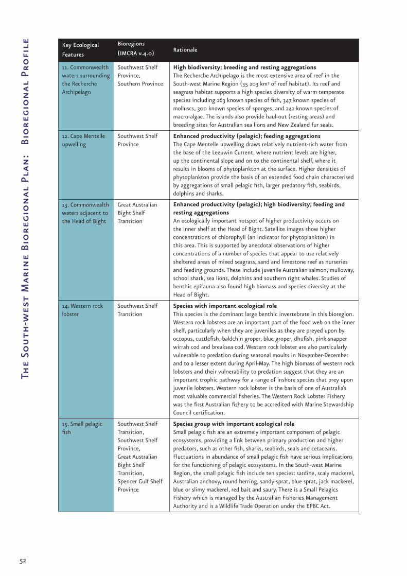
52
The
Sou
th-w
est
Mar
ine
Bio
regi
on
al P
lan
: B
iore
gio
nal
Pro
file Key Ecological
Features
Bioregions
(IMCRA v.4.0) Rationale
11. Commonwealth waters surrounding the Recherche Archipelago
Southwest Shelf Province,Southern Province
High biodiversity; breeding and resting aggregationsThe Recherche Archipelago is the most extensive area of reef in the South-west Marine Region (35 203 km2 of reef habitat). Its reef and seagrass habitat supports a high species diversity of warm temperate species including 263 known species of fish, 347 known species of molluscs, 300 known species of sponges, and 242 known species of macro-algae. The islands also provide haul-out (resting areas) and breeding sites for Australian sea lions and New Zealand fur seals.
12. Cape Mentelle upwelling
Southwest Shelf Province
Enhanced productivity (pelagic); feeding aggregationsThe Cape Mentelle upwelling draws relatively nutrient-rich water from the base of the Leeuwin Current, where nutrient levels are higher, up the continental slope and on to the continental shelf, where it results in blooms of phytoplankton at the surface. Higher densities of phytoplankton provide the basis of an extended food chain characterised by aggregations of small pelagic fish, larger predatory fish, seabirds, dolphins and sharks.
13. Commonwealth waters adjacent to the Head of Bight
Great Australian Bight Shelf Transition
Enhanced productivity (pelagic); high biodiversity; feeding and resting aggregationsAn ecologically important hotspot of higher productivity occurs on the inner shelf at the Head of Bight. Satellite images show higher concentrations of chlorophyll (an indicator for phytoplankton) in this area. This is supported by anecdotal observations of higher concentrations of a number of species that appear to use relatively sheltered areas of mixed seagrass, sand and limestone reef as nurseries and feeding grounds. These include juvenile Australian salmon, mulloway, school shark, sea lions, dolphins and southern right whales. Studies of benthic epifauna also found high biomass and species diversity at the Head of Bight.
14. Western rock lobster
Southwest Shelf Transition
Species with important ecological roleThis species is the dominant large benthic invertebrate in this bioregion. Western rock lobsters are an important part of the food web on the inner shelf, particularly when they are juveniles as they are preyed upon by octopus, cuttlefish, baldchin groper, blue groper, dhufish, pink snapper wirrah cod and breaksea cod. Western rock lobster are also particularly vulnerable to predation during seasonal moults in November-December and to a lesser extent during April-May. The high biomass of western rock lobsters and their vulnerability to predation suggest that they are an important trophic pathway for a range of inshore species that prey upon juvenile lobsters. Western rock lobster is the basis of one of Australia’s most valuable commercial fisheries. The Western Rock Lobster Fishery was the first Australian fishery to be accredited with Marine Stewardship Council certification.
15. Small pelagic fish
Southwest Shelf Transition,Southwest Shelf Province,Great Australian Bight Shelf Transition,Spencer Gulf Shelf Province
Species group with important ecological roleSmall pelagic fish are an extremely important component of pelagic ecosystems, providing a link between primary production and higher predators, such as other fish, sharks, seabirds, seals and cetaceans. Fluctuations in abundance of small pelagic fish have serious implications for the functioning of pelagic ecosystems. In the South-west Marine Region, the small pelagic fish include ten species: sardine, scaly mackerel, Australian anchovy, round herring, sandy sprat, blue sprat, jack mackerel, blue or slimy mackerel, red bait and saury. There is a Small Pelagics Fishery which is managed by the Australian Fisheries Management Authority and is a Wildlife Trade Operation under the EPBC Act.

53
Conservation Values
Key Ecological
Features
Bioregions
(IMCRA v.4.0) Rationale
16. Demersal slope fish communities
Central Western Province
Communities with high species biodiversityDemersal slope fish assemblages in this bioregion are characterised by high species diversity. Scientists have described 480 species of demersal fish that inhabit the slope of this bioregion and 31 of these are considered endemic to the bioregion. Demersal fish on the slope in this bioregion in particular have high species diversity compared with other more intensively sampled oceanic regions of the world. Below 400 m water depth demersal fish communities are characterised by a diverse assemblage where relatively small, benthic species (grenadiers, dogfish and cucumber fish) dominate.
17. Benthic invertebrate communities of the eastern Great Australian Bight
Great Australian Bight Shelf Transition
Communities with high species biodiversitySoft-sediment benthic invertebrate communities of the eastern Great Australian Bight shelf form some of the world’s most diverse soft sediment ecosystems. A 2002 survey of benthic marine life sampled 798 species, including 360 species of sponge, 138 ascidians and 93 bryozoans, many of which were new to science. The shelf in this area of the Region is part of the world’s largest cool-water carbonate province. Invertebrate skeletons and shells make up over 80 per cent of the shelf sediments.
Large erect sponges with a mixture of small sponges, cnidarians and bryozoans. Southern Province, 193 m deep. Photo: CSIRO.

54
The
Sou
th-w
est
Mar
ine
Bio
regi
on
al P
lan
: B
iore
gio
nal
Pro
file 3.2 Nationally protected
species
Species listed under the EPBC Act are commonly referred
to as ‘protected species’ because it is an offence to kill,
injure, take, trade, keep or move a listed species without
authorisation. Under the EPBC Act, species can be listed
as threatened, migratory, cetaceans or as marine:
Threatened species – are those species that have been
identified as being in danger of becoming extinct;
Listed Migratory species – are those species that are
listed under:
the Convention on the Conservation of Migratory
Species of Wild Animals (also known as the CMS
or Bonn Convention),
the Agreement between the Government of Australia
and the Government of Japan for the Protection of
Migratory Birds in Danger of Extinction and their
Environment 1974 (JAMBA),
the Agreement between the Government of
Australia and the Government of the People’s
Republic of China for the Protection of Migratory
Birds and their Environment 1986 (CAMBA), or
any other international agreement, or
instrument made under other international
agreements approved by the Minister for the
Environment, Heritage and the Arts.
Further information on the CMS, JAMBA and
CAMBA is provided in Appendix A;
Cetaceans – all species of cetacean (including
whales, dolphins and porpoises) are protected under
the EPBC Act to ensure their future survival; and
Listed marine species – species belonging to taxa that
the Australian Government recognises as requiring
protection to ensure their long-term conservation
(in accordance with Section 248 of the EPBC Act).
Listed marine species occurring in the South-west
include:
sea snakes (Families Hydrophiidae and
Laticaudidae),
pinnipeds, including fur seals and sea lions and
true seals (Families Otariidae and Phocidae),
marine turtles (Families Cheloniidae and
Dermochelyidae),
•
•
•
•
•
•
•
•
•
•
•
seahorses, sea-dragons, pipefish and ghost
pipefish (Families Syngnathidae and
Solenostomidae), and
seabirds (i.e. defined in the EPBC Act as
bird species that occur naturally in the
Commonwealth marine area).
Species can also be listed under more than one category;
for instance marine turtles are listed as threatened
species, migratory species and as marine species.
Under the EPBC Act, species listed as ‘threatened’ or
‘migratory’ are matters of national environmental
significance1. Proposals for activities likely to have a
significant impact on matters of national environmental
significance must be referred to the Australian
Government Minister for the Environment, Heritage and
the Arts for approval. The requirement to refer proposals
for actions likely to have a significant impact on matters
of national environmental significance applies to
activities proposed not only in areas managed by the
Commonwealth but also in areas managed by the States
and Territories.
Significant Impact Guidelines – Matters of National
Environmental Significance have been produced to provide
advice to proponents on when referrals should be
submitted for approval. These guidelines provide specific
advice about the kinds of actions likely to have a
significant impact on threatened and migratory species.
The guidelines also provide specific advice about the
kinds of actions likely to have a significant impact on
the Commonwealth marine environment. Under these
guidelines for the Commonwealth marine environment,
any actions that will, or are likely to, “have a substantial
adverse effect on a population of a marine species or
cetacean including its life cycle (e.g. breeding, feeding,
migratory behaviour, life expectancy) and spatial
distribution” are identified as actions that should be
referred for approval. These guidelines are available at
<www.environment.gov.au/epbc/policy>.
Species listed under the EPBC Act are also protected
from adverse interactions with commercial fishing
operations. Under the EPBC Act all fisheries managed
under Commonwealth legislation, and State-managed
fisheries that have an export component, must be
assessed to ensure that, over time, fisheries are managed
in an ecologically sustainable way. These fishery
1 Species listed as extinct or conservation dependent are not matters of national environmental significance under the EPBC Act.
•
•

55
Conservation Values
assessments are conducted using the Guidelines for the
Ecologically Sustainable Management of Fisheries. These
guidelines specify that fisheries must be conducted in
a manner that does not threaten by-catch species and
that “avoids mortality of, or injuries to, endangered,
threatened or protected species.” Further information
about fisheries assessments carried out under the EPBC
Act is available at <www.environment.gov.au/coasts/
fisheries>.
The EPBC Act includes other forms of protection for
listed species to ensure that human activities do not
threaten their survival in the wild (see Appendix B for
further information and relevant links).
3.2.1 Protected species in the South-
west Marine Region
The South-west Marine Region is an important area for
many species that are protected under the EPBC Act.
Many of the species listed under the EPBC Act are also
protected under State legislation. For instance the white
shark is protected under the EPBC Act and under South
Australian and Western Australian legislation.
In the South-west Marine Region there are 105 species
protected under the EPBC Act that are known to occur
in the Region: 26 species listed as threatened, 49 as
migratory, 31 cetaceans and 70 listed as marine (Table
3.2)2. In addition, there are another 77 species that
may infrequently occur in the Region. Species that may
infrequently occur in the South-west Marine Region are
defined as those:
that are accidental visitors to the Region; or
that on the basis of available information
about their range are considered as species
that may occur in the Region.
Appendix C lists all species protected under the EPBC Act
that are known to occur and all that may infrequently occur
in the South-west Marine Region.
Note that, at the time of finalisation of this Bioregional
Profile (2007), there are no species listed as ‘critically
endangered’. There are also no species known to have
become extinct in the Region.
2 Species can be listed under more than one category under the EBPC Act. For instance, marine turtles are listed as threatened species, migratory species and as marine species.
•
•
Protected Species Group Report Cards have been
prepared for each of the broad taxonomic groups
listed under the EPBC Act that are known to occur in
the Region (Appendix D). The report cards identify the
threatened and migratory listed species that are known
to occur in the South-west Marine Region, describe their
ecology, identify the important areas for them within
the Region, explain what processes and activities pose
a threat to their continued survival and identify how
these threats are being mitigated. The report cards also
point to relevant references and research for further
reading. The report cards are available on the internet at
<www.environment.gov.au/coasts/mbp/south-west> and
will be updated as new information becomes available.
Protected Species Group Report Cards are available for
sharks, fish, reptiles (marine turtles and sea-snakes),
birds, pinnipeds (seals, fur seals and sea lions), and
cetaceans (whales, dolphins and porpoises) occurring in
the South-west Marine Region.
Shy albatross. Photo: Mike Double.

56
The
Sou
th-w
est
Mar
ine
Bio
regi
on
al P
lan
: B
iore
gio
nal
Pro
file Table 3.2 Number of protected species known to occur in the Region by broad taxonomic group (as at April 2007)
Listed Threatened Species Listed
Migratory
Species
Cetaceans
(whales, dolphins
and porpoises)
Listed
Marine
SpeciesEndangered VulnerableConservation
Dependent
Sharks - 3 - 2 - -
Bony fish - - 1 - - 1
Reptiles 1 2 - 3 - 4
Seabirds 2 11 - 35 - 62
Pinnipeds - 1 - - - 3
Cetaceans 2 3 - 9 31 -
Totals 26 49 31 70
Important areas for species listed as ‘threatened’ or
‘migratory’ under the EPBC Act have been identified in
the South-west Marine Region and in adjacent State
waters. These important areas have been identified for
species listed as ‘threatened’ or ‘migratory’ under the
EPBC Act as they are matters of national environmental
significance (see Chapter 3.2 for further information on
requirements under the EPBC Act for matters of national
environmental significance).
Table 3.3 identifies breeding areas, nursery and calving
areas, feeding areas and resting areas for protected
sharks, fish, reptiles, seabirds (foraging areas only),
pinnipeds and cetaceans within the South-west Marine
Region. Table 3.4 identifies sea bird rookeries adjacent
to the Region on islands and coastal areas. These areas
were identified on the basis of available information,
expert advice and the criteria below:
Sharks: nursery grounds and feeding areas;
Fish (orange roughy): aggregations;
•
•
Reptiles (marine turtles): foraging areas;
Seabirds: rookeries and known feeding areas;
Pinnipeds (seals, fur seals and sea lions):
breeding colonies and surrounding waters; and
Cetaceans (whales, dolphins and porpoises):
feeding areas, calving areas and resting areas on
migratory routes in the Region.
Additional important areas for species protected under
the EPBC Act may be identified during the next stage
of the planning process, as further and finer-scale
information about the Region is collected to underpin
the analysis of the threats protected species may face
over the next 10-20 years. The Draft South-west Marine
Bioregional Plan will include any additional important
areas identified for protected species.
•
•
•
•
Australian sea lion.Photo: David Muirhead, Marine Life Society of South Australia.

57
Conservation Values
Table 3.3 Important breeding, feeding and resting areas for species listed as threatened or migratory under the EPBC Act
Where available, further information and references for important areas for threatened and migratory species are
provided in Appendix D of this Bioregional Profile.
Important Areas Rationale
Inshore waters of the Great Australian Bight, including the Head of Bight
Nursery area – white sharkSmall juvenile white sharks (less than 2 m in length) are commonly encountered in this area. It is presumed that the apparent abundance of small white sharks in this area is the result of pupping in or near this area.Feeding area – white sharkMovements of white sharks are known to increase seasonally at the Head of Bight and may be linked to the seasonal availability and movements of prey including snapper, gummy sharks, Australian salmon and to the calving of southern right whales.Calving area – southern right whaleThe Head of Bight is one of the main southern right whale calving areas in SA.
Pinniped (seal and sea lion) colonies
Breeding area – Australian sea lionFive of the known breeding sites for Australian sea lions produce more than 100 pups each year, representing more than 50 per cent of all pups born. These five sites are all off SA: Dangerous Reef (Southern Eyre Peninsula); the Pages Islands (outside the South-west Marine Region); West Waldegrave Island (Western Eyre Peninsula); Seal Bay (Kangaroo Island); and Olive Island (Western Eyre Peninsula). However, because of the closed breeding patterns of Australian sea lions and their threatened conservation status it is considered that all breeding sites for Australian sea lions are significant.Feeding area – white sharkEvidence indicates that pinniped colonies are areas where white sharks can aggregate or frequently revisit to feed. In addition to the Australian sea lion colonies, most of the known breeding sites for the New Zealand fur seal are found in the Region (30 in SA and 17 in WA). Large breeding populations in the Region are at North and South Neptune Islands, Kangaroo Island and Liguanea Island, which account for more than 80 per cent of the national pup production for the species.
Spencer Gulf and Gulf St Vincent
Feeding area – white sharkThese gulfs are considered important feeding grounds for sub-adult white sharks, although juvenile and large adult sharks have also been observed in these areas. Dolphins, finfish and other elasmobranchs which are abundant here are thought to be targeted by white sharks occurring in these gulfs.
Waters in the east of the Great Australian Bight
Aggregation – orange roughyAggregations have been targeted by commercial fishers in the Great Australian Bight Trawl Fishery sector of the Southern and Eastern Scalefish and Shark Fishery, particularly during the late 1980s and early 1990s, when large catches were taken in some years.
Albany Canyons Group and adjacent shelf break
Aggregation – orange roughyAggregations are known to occur, and have been targeted by commercial fishers. With the decline of the fished aggregation in the eastern Great Australian Bight, virtually all recent (mid 1990s – early 2000s) orange roughy catches in the Region have been taken from two areas off WA, described as the ‘Albany Hills’ and ‘Esperance’ stocks.Feeding area – sperm whaleSperm whales have been recorded as being concentrated in a narrow area only a few kilometres wide at the shelf edge off Albany, WA.
Kangaroo Island canyons and adjacent shelf break
Aggregation – orange roughyAggregations are known to occur in the area, including in the vicinity of the Murray Canyons, which is near the eastern boundary of the Region. Feeding area – pygmy blue whale, fin whale and sperm whaleThis area is a feeding area for pygmy blue whales, fin whales, sperm whales and possibly sei whales.
continued overleaf

58
The
Sou
th-w
est
Mar
ine
Bio
regi
on
al P
lan
: B
iore
gio
nal
Pro
file Important Areas Rationale
Houtman Abrolhos Islands and surrounding waters
Feeding area – Australian lesser noddyThe sub-species is only known to forage between the islands and the continental shelf edge. Foraging area – green turtleAlthough the importance of this area to the species is not well understood, resident adult green turtles are observed at the reefs of the Houtman Abrolhos Islands.Resting area – humpback whaleHumpback whales are known to rest in this area on migration. Sightings of Bryde’s whales also suggest this area may be important for this rarely sighted species.
Doubtful Islands Bay Calving area – southern right whaleThis area is one of the main calving areas for southern right whales in WA.
Israelite Bay Calving area – southern right whaleThis area is one of the main calving areas for southern right whales in WA.
Fowlers Bay Calving area – southern right whaleThis area is one of the main calving areas for southern right whales in SA.
Albany/ Cape Riche area Calving area – southern right whaleThis area is one of the main calving areas for southern right whales in WA.
Yokinup Bay/Cape Arid area
Calving area – southern right whaleThis is one of the main calving areas for southern right whales in WA.
Perth Canyon Feeding area – pygmy blue whaleThe Perth Canyon is a seasonally important aggregation area for krill at depths of 200-300 m and attracts many species of krill feeders, in particular pygmy blue whales. Fin whales have also been observed in the area and it is thought that sei whales may also feed there.
Waters from Rottnest Island to Geographe Bay
Resting area – humpback whaleThe bay and surrounding waters are an important resting area for humpback whales, particularly cow-calf pairs, as they migrate south at the end of the breeding season. Recent surveys have also detected southern right whales in the area and have shown an increasing number of pygmy blue whales using the bay in spring. They have been further observed passing through the shelf area between Cape Naturaliste and Rottnest Island, however the ecological or functional significance of the area to the species is unclear.Foraging area – loggerhead turtleAlthough the importance of this area to the species is not well understood, resident adult loggerhead turtles and sub-adult turtles are known to forage in this area.
Waters off the mid-west to south-west coast of WA
Foraging area – leatherback turtle Although the importance of this area to the species is not well understood, leatherback turtles are known to feed in pelagic waters along the mid-west and south-west coast of WA. Adult leatherback turtles have also been observed feeding in inshore waters, including in the Swan River estuary. The southern extent of leatherback turtles in WA is not well understood. They have been found stranded and caught as by-catch in fisheries along the southern coast of WA.
Coastal reefs around Kalbarri
Foraging area – green turtleAlthough the importance of this area to the species is not well understood, resident adult green turtles are observed in this area.
Jurien Bay south to Rottnest Island
Foraging area – juvenile green turtleAlthough the importance of this area to the species is not well understood, large juvenile green turtles are observed in this area.
Waters surrounding Cape Leeuwin/Flinders Bay
Resting area – humpback whaleHumpback whales are known to rest in this area on migration.
Twilight Cove Calving area – southern right whaleThis area is one of the main calving areas for southern right whales in WA.

59
Conservation Values
Table 3.4 Seabird rookeries on islands and coastal areas adjacent to the South-west Marine Region
Nesting areas Nesting species
Houtman Abrolhos Islands Australian lesser noddy (Morley Island, Wooded Island and Pelsaert Island)Common noddy (Pelsaert Island)Bridled tern (Leo Island, Pelsaert Island, Little North Island)Caspian tern (Leo Island, West Wallabi Island and Pelsaert Island)Osprey (Pelsaert Island)White-bellied sea eagle (West Wallabi Island)Wedge-tailed shearwater
Rottnest Island Wedge-tailed shearwaterBridled tern
Recherche Archipelago Flesh-footed shearwaterShort-tailed shearwaterCaspian TernWhite-bellied sea eagle
Penguin Island Bridled tern
Eyre Peninsula OspreyWhite-bellied sea eagle
Kangaroo Island Osprey
Lancelin Island Wedge-tailed shearwater Bridled tern
Safety Bay Wedge-tailed shearwater Bridled tern
Great Althorpe Island Short-tailed shearwater
Cape Hamelin Flesh-footed shearwater
Yorke Peninsula White-bellied sea eagle
Nuyts Archipelago Caspian ternFlesh-footed shearwater Short-tailed shearwater
Neptune Islands (including North and South Neptune)
Short-tailed shearwater Caspian tern
Gambier Island Short-tailed shearwater
Lewis, Hopkins and Williams Islands (near Cape Catastrophe)
Short-tailed shearwater
Greenly Island Short-tailed shearwater
Investigator Group Short-tailed shearwater
West Troubridge Shoal Caspian tern
Sir Joseph Banks Group Caspian tern
Eyre Island and Little Eyre Island
Caspian tern
Fisherman Islands Bridled tern
Beagle Islands Bridled tern

60
The
Sou
th-w
est
Mar
ine
Bio
regi
on
al P
lan
: B
iore
gio
nal
Pro
file 3.2.2 Flagship species of the South-
west Marine Region
‘Flagship’ species have been identified in the South-west
Marine Region on the basis of their unique association
with the Region and its habitats. The concept of
flagship species is not legislative and it does not change
the conservation status or associated provisions under
the EPBC Act. Identifying species that are uniquely
associated with a Region – that is, flagship species – is
useful for education purposes and to raise awareness
about marine conservation matters among the public.
Flagship species of the South-west Marine Region are
the white shark, the Australian lesser noddy, the great-
winged petrel, the Australian sea lion, the southern right
whale and the beaked whales (which include at least five
separate species). Further information on these species
can be found in Appendix D.
White shark – The white shark (Carcharodon carcharias)
is listed both as a threatened and a migratory species
under the EPBC Act. It is classified as a vulnerable
species for a number of reasons, including evidence of
a declining population, its life history characteristics
(long-lived with low levels of reproduction), limited local
distribution and abundance and, at the time of listing,
pressure from commercial fishing.
White shark. Photo: Rachel Robbins, Fox Shark Research Station.
Although the white shark is a wide-ranging species that
is found in all seas, the South-west Marine Region
appears to be an important area for the species. Available
records of incidental catches of white sharks in
Australian waters are higher in the South-west Marine
Region than in any other region, and are not well
correlated with fishing effort. Fishing activities along
the west coast of Western Australia (Shark Bay to
Bunbury) and in the Great Australian Bight appear to
have significantly higher interactions with white sharks
than in other areas, which indicates that these areas
may be particularly important for the species. Because
of the internationally threatened status of this species
the Region may also be significant for the conservation
and management of white sharks not only in Australian
terms, but possibly also in a global context.
Australian lesser noddy – The Australian lesser noddy
(Anous tenuirostris melanops) is listed as a marine and a
threatened species under the EPBC Act. It is classified as
a vulnerable species under the EPBC Act for a number
of reasons including past population decline, possibly
associated with guano mining in the Houtman Abrolhos
Islands and the species’ limited distibution.
Australian lesser noddy. Photo: WA Department of Environment and Conservation, Bert and Bab Wells.
The most significant breeding rookeries for the
Australian lesser noddy are found in the Houtman
Abrolhos Islands on Morley, Wooded and Pelsaert Islands.
These islands are adjacent to the South-west Marine
Region, and the species is known to forage both around
breeding colonies and well out to sea.
Great-winged petrel – The great-winged petrel
(Pterodroma macroptera) is listed as a marine species
under the EPBC Act. The great-winged petrel is not listed
as a threatened species under the EPBC Act as it has not
been determined as a species threatened by extinction.
Great-winged petrel. Photo: Andrew Burbridge, WA Department of Environment and Conservation.
The great-winged petrel is the only petrel species that
breeds adjacent to the Region. In addition, in Australia
the great-winged petrel is only known to breed on islands
of the Recherche Archipelago and islands offshore of
Albany that are adjacent to the South-west Marine
Region, with some 33 000 breeding pairs estimated to
breed on the islands of the Recherche Archipelago.

61
Conservation Values
Australian sea lion – The Australian sea lion (Neophoca
cinerea) is listed as a marine and threatened species
under the EPBC Act. It is classified as a vulnerable
species under the EPBC Act for a number of reasons
including lack of population recovery since the end of
commercial sealing.
Australian sea lion. Photo: Glen Cowans.
The Australian sea lion is the only endemic species of
pinniped in Australia and is currently found only on the
west and south coasts of Western Australia, and on the
coast of South Australia, although its historic range was
far more extensive. It has 66 breeding colonies on
islands from the Houtman Abrolhos Islands near
Geraldton in Western Australia, to the Pages Islands near
Kangaroo Island in South Australia. All of these colonies
of Australian sea lions except the Pages Islands colony
are on islands adjacent to the South-west Marine Region.
All breeding colonies of the Australian sea lion are
considered significant for the conservation of the
species as it is known to have a low reproductive rate
and a restricted capacity to form new colonies. Their
limited capacity to form new breeding colonies is
because females tend to return to the colony where they
were born to reproduce.
Southern right whale – The southern right whale
(Eubalaena australis) is listed as a cetacean and as a
threatened and migratory species under the EPBC Act.
It is classified as an endangered species under the EPBC
Act. Southern right whales were heavily exploited for
their oil and baleen in the early 1800s. Low level catches
continued until at least the 1930s when worldwide
protection for right whales was introduced in 1935.
However, illegal catches continued until the late
1970s. Since the introduction of a moratorium on all
commercial whaling in 1985/6 the Australian population
of southern right whales has shown signs of a slow,
steady recovery.
Southern right whales migrate each year from cold sub-
Antarctic waters to breed and calve. They breed while
fasting during winter-spring in shallow waters across Hector’s beaked whale. Photo: Nick Gales, Australian Government Antarctic Division.
the south of the continent, with the majority of the
Australian population of southern right whales breeding
in the South-west Marine Region. The main calving areas
(based on observations of mothers with very young
calves in multiple years) currently known for southern
right whales within and adjacent to the South-west
Marine Region include: Doubtful Islands Bay (including
Point Ann/Point Charles area), Israelite Bay area,
Twilight Cove, Flinders Bay, Albany/Cape Riche area, and
Yokinup Bay/Cape Arid area, Head of the Bight, Fowlers
Bay, and Encounter Bay.
Beaked whales – Beaked whales are the least well
studied of all marine mammals. This is primarily because of
their oceanic distribution and their preferences for deep
waters beyond the shelf edge, where few research vessels
visit. However, a recent study by MacLeod and Mitchell
(2006) indicates that waters south-west of Australia are
probably important areas for beaked whales. Despite the
limited number of recorded sightings (19) reported in
this study in waters off south-west Australia, five species
of beaked whales have been recorded. These include the
poorly known Hector’s beaked whale (Mesoplodon hectori)
and Andrews’ beaked whale (Mesoplodon bowdoini). Both
of these species are also known from recorded strandings
in Western Australia and South Australia. Cuvier’s beaked
whale (Ziphius cavirostris) has also been recorded at sea
in this area and from a number of recorded strandings in
Western Australia and South Australia.
Southern right whale and calf. Photo: Clive McMahon, Australian Government Antarctic Division.
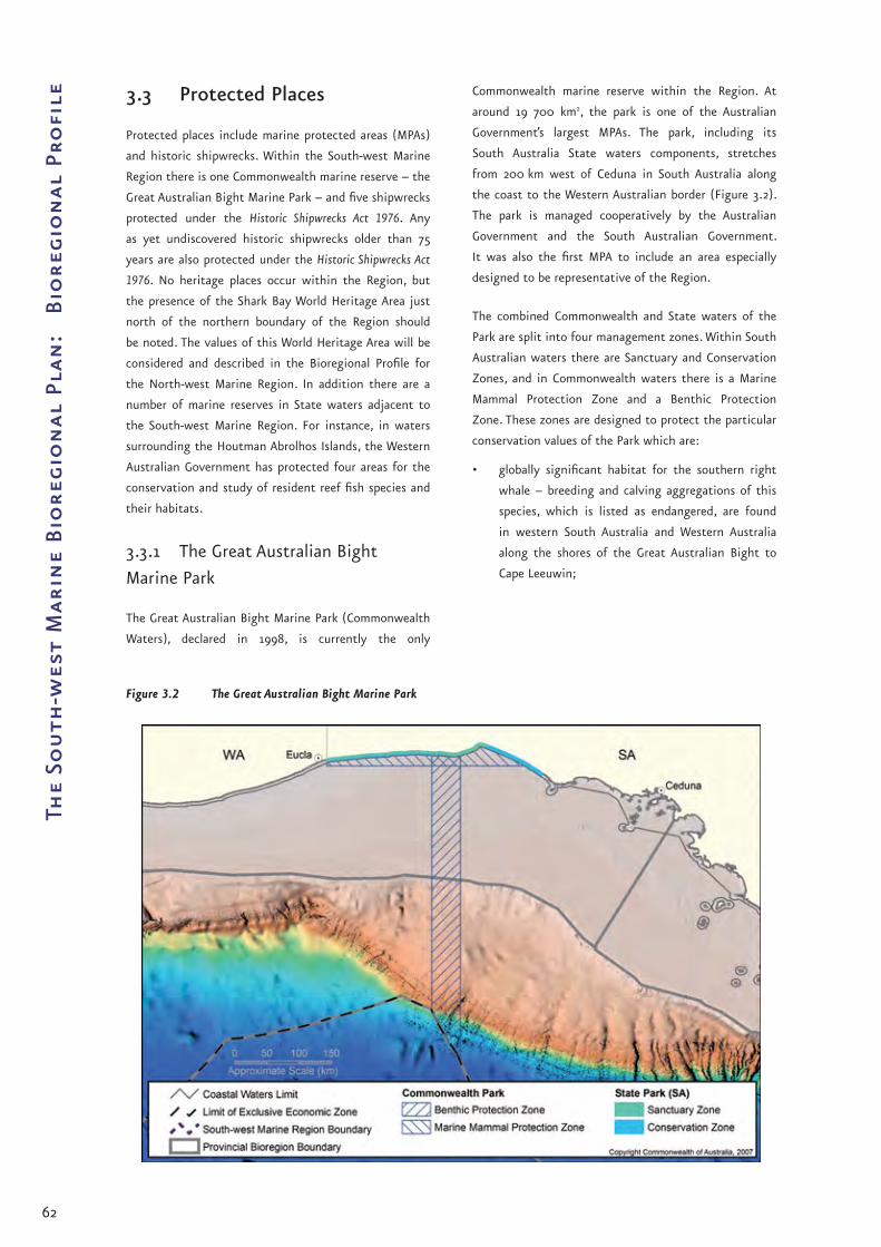
62
The
Sou
th-w
est
Mar
ine
Bio
regi
on
al P
lan
: B
iore
gio
nal
Pro
file 3.3 Protected Places
Protected places include marine protected areas (MPAs)
and historic shipwrecks. Within the South-west Marine
Region there is one Commonwealth marine reserve – the
Great Australian Bight Marine Park – and five shipwrecks
protected under the Historic Shipwrecks Act 1976. Any
as yet undiscovered historic shipwrecks older than 75
years are also protected under the Historic Shipwrecks Act
1976. No heritage places occur within the Region, but
the presence of the Shark Bay World Heritage Area just
north of the northern boundary of the Region should
be noted. The values of this World Heritage Area will be
considered and described in the Bioregional Profile for
the North-west Marine Region. In addition there are a
number of marine reserves in State waters adjacent to
the South-west Marine Region. For instance, in waters
surrounding the Houtman Abrolhos Islands, the Western
Australian Government has protected four areas for the
conservation and study of resident reef fish species and
their habitats.
3.3.1 The Great Australian Bight
Marine Park
The Great Australian Bight Marine Park (Commonwealth
Waters), declared in 1998, is currently the only
Commonwealth marine reserve within the Region. At
around 19 700 km2, the park is one of the Australian
Government’s largest MPAs. The park, including its
South Australia State waters components, stretches
from 200 km west of Ceduna in South Australia along
the coast to the Western Australian border (Figure 3.2).
The park is managed cooperatively by the Australian
Government and the South Australian Government.
It was also the first MPA to include an area especially
designed to be representative of the Region.
The combined Commonwealth and State waters of the
Park are split into four management zones. Within South
Australian waters there are Sanctuary and Conservation
Zones, and in Commonwealth waters there is a Marine
Mammal Protection Zone and a Benthic Protection
Zone. These zones are designed to protect the particular
conservation values of the Park which are:
globally significant habitat for the southern right
whale – breeding and calving aggregations of this
species, which is listed as endangered, are found
in western South Australia and Western Australia
along the shores of the Great Australian Bight to
Cape Leeuwin;
•
Figure 3.2 The Great Australian Bight Marine Park

63
Conservation Values
haul-out, breeding and foraging grounds for the
Australian sea lion, a species that occurs only in
Australia’s southern waters on offshore islands from
the Houtman Abrolhos Islands off Western Australia
to Kangaroo Island, and on some mainland South
Australian sites; and
habitat for other species of conservation
significance, such as the humpback whale, the
white shark and several species of albatross.
The Great Australian Bight Marine Park contributes
to the National Representative System of MPAs by
protecting a representative transect of the seabed on
the continental shelf and slope of the Great Australian
Bight.
Several unique factors combine to contribute to the
high level of biodiversity and endemism in the area
of the park. These include a long period of geological
isolation, a persistent high wind and wave energy
environment, warm-water intrusion via the Leeuwin
current from Western Australia, and cold-water, nutrient-
rich upwellings in the east. Taxonomic groups with
exceptional diversity in this area include red algae (sea
weed), ascidians (sea squirts), bryozoans (lace corals),
molluscs (shellfish) and echinoderms (sea urchins and
sea stars).
The EPBC Act (Section 354) prohibits actions affecting
native species inside the park unless authorised under
the Great Australian Bight Marine Park (Commonwealth
Waters) Management Plan 2005-2012. The plan currently
allows a range of activities, including fishing and
scientific research, to be carried out under permit from
the Director of National Parks. Other provisions of
the EPBC Act prevent activities that affect species of
particular conservation interest (in the park or other
Commonwealth waters), and control actions that
could have a ‘significant’ impact on the Commonwealth
marine environment, including the park’s seabed. The
park’s management plan supplements this protection by
minimising disturbances to areas of habitat important
to these species, and prohibiting disturbances to the
seabed by benthic trawling, while allowing for other
ecologically sustainable activities in the park.
Further information on the Great Australian Bight
Marine Park is available at <www.environment.gov.au/
coasts/mpa>.
•
•
3.3.2 Historic shipwrecks
Within the South-west Marine Region there are currently
five known historic shipwrecks protected under the
Historic Shipwrecks Act 1976 (note however that many
more shipwrecks are located in State waters). These are
the:
SS Cambewarra, a steam powered transport vessel
that was wrecked in 1914 near Fisherman’s Island,
80 km south of Dongara, Western Australia;
Red Rover, a fishing boat wrecked in September
1887 near Coffin Bay, South Australia;
Lord Roberts, wrecked in 1902 in the Gulf St Vincent
Region, South Australia;
HMAS Sydney II, wrecked in 1941 while engaged
in battle with the HSK Kormoran, approximately
250 km off the mid-west coast of Western Australia;
and
HSK Kormoran, wrecked in 1941 while engaged
in battle with the HMAS Sydney II, approximately
250 km off the mid-west coast of Western Australia.
The HMAS Sydney II and German raider HSK Kormoran were
found in March 2008, some 66 years after they were
lost. The Minister for the Environment, Heritage and
the Arts has placed a provisional declaration over the
HMAS Sydney II and German raider HSK Kormoran under
the Historic Shipwrecks Act 1976. The declaration gives
legal protection to these historically significant vessels
and relics, from damage, disturbance or removal. Under
the provisional declaration, unauthorised damage,
disturbance or removal of the sites is prohibited. This
action will ensure respect for all those that died in the
battle but will not prevent further documentation of the
site.
It should be noted that information about the location
of shipwrecks is often approximate and that other
historic shipwrecks may be located within the Region.
Figure 3.3 shows the locations of known historic
shipwrecks within the South-west Marine Region.
•
•
•
•
•

64
The
Sou
th-w
est
Mar
ine
Bio
regi
on
al P
lan
: B
iore
gio
nal
Pro
file Figure 3.3 Historic shipwrecks with known locations in the South-west Marine Region
Historic shipwrecks are recognised and protected under
the Historic Shipwrecks Act 1976, which protects historic
wrecks and associated relics found in waters from the
low water mark to the edge of the continental shelf.
Under the Historic Shipwrecks Act, all wrecks more
than 75 years old are protected, together with their
associated relics. The Minister for the Environment,
Heritage and the Arts can also make a declaration to
protect any historically significant wrecks or articles and
relics that are less than 75 years old.
The Historic Shipwrecks Act aims to ensure that
historic shipwrecks are protected for their heritage
values and maintained for recreational and educational
purposes. It also regulates activities that may result in
the damage, interference, removal or destruction of an
historic shipwreck or associated relic. Under the Historic
Shipwrecks Act:
anyone who finds the remains of a ship or
articles associated with a ship is required to give
notification of the location as soon as practicable
to the Minister for the Environment, Heritage and
the Arts; and
historic relics must not be removed, or the physical
fabric of a wreck disturbed, unless a permit has
been obtained.
•
•
The Historic Shipwrecks Act also provides for protected
zones to be declared around wrecks that are at particular
threat from interference. Permits are required to enter
protected zones, which can cover an area up to a radius
of 800 m. There are currently no declared protected
zones under the Historic Shipwrecks Act in the South-
west Marine Region.
Further information about historic shipwrecks
and the Historic Shipwrecks Act can be found at
<www.environment.gov.au/heritage/shipwrecks>.
Bryozoans. Photo: Marine Life Society of South Australia.

65
Conservation Values
3.4 Consideration of pressures on regional conservation values
There are a range of pressures impacting, or potentially
impacting upon conservation values in the Region.
Many of these are outlined in Appendix D (i.e. those of
relevance to threatened and migratory species) and in
the Coasts and Oceans chapter of the 2006 State of the
Environment Report.
Of additional concern are the potential impacts of
climate change on the marine environment. Valuable
information on climate change impacts and adaptation
in the marine environment can be found in the 2006
CSIRO Report Impacts of Climate Change on Australian Marine
Life <www.greenhouse.gov.au/impacts/publications/
marinelife.html>. The report provides a detailed
overview of the potential impacts climate change
could have on marine biodiversity and ecosystems. It
also proposes research and adaptation strategies to
ameliorate climate change impacts.
The information collected during the profiling stage
will inform how pressures on the regional conservation
values described in this chapter, will be addressed in the
South-west Marine Bioregional Plan.
Chapter 6 of this Bioregional Profile contains more
information about how and when in the process,
stakeholders’ input will be sought to inform the
development of the Draft Plan.
Long-snouted boarfish. Photo: Marine Life Society of South Australia.

66
The
Sou
th-w
est
Mar
ine
Bio
regi
on
al P
lan
: B
iore
gio
nal
Pro
file Key references and further
readings
Beeton, R.J.S., Buckley, K.I., Jones, G.J., Morgan, D.,
Reichelt, R.E., Trewin, D., 2006, Australian State of the
Environment 2006, Department of the Environment
and Heritage, Canberra, <www.environment.gov.au/
soe/2006>, accessed 14/05/07.
Department of Fisheries, Western Australia, 2007,
Abrolhos Islands Visitor Guide, <www.fish.wa.gov.au/docs/
pub/AbrolhosVisiting/AbrolhosVisitingPage06.php>,
accessed on 23/05/07.
Department of the Environment and Heritage (DEH),
2005, Recovery Plans 2005-2010 for Australia’s Threatened
Whales: Humpback, Southern Right, Blue, Fin and Sei, DEH,
Canberra.
Department of the Environment and Heritage (DEH),
2006, A Guide to the Integrated Marine and Coastal
Regionalisation of Australia Version 4.0, DEH, Canberra,
<www.environment.gov.au/coasts/mbp/publications/
imcra>, accessed 07/05/07.
Department of the Environment and Water Resources
(DEW), 2006, Characterisation of the marine environment of
the South-west Marine Region: Perth Workshop Report, DEW,
Canberra, <www.environment.gov.au/coasts/mbp/
south-west>.
Gales, N.J., Dalebout, M.L., & Bannister, J., 2002,
‘Genetic identification and biological observation of two
free-swimming beaked whales: Hector’s Beaked Whale
(Mesoplodon hectori, Gray, 1871), and Gray’s Beaked Whale
(Mesoplodon grayi, Von Haast, 1876)’, Marine Mammal
Science 18: 544-551.
Hobday, A.J., Okey, T.A., Poloczanska, E.S., Kunz,
T.J. & Richardson, A.J. (eds), 2006, Impacts of
climate change on Australian marine life, report to the
Australian Greenhouse Office, Canberra, Australia.
<www.greenhouse.gov.au/impacts/publications/
marinelife.html> accessed 14/05/07.
MacLeod, C.D., & Mitchell, G., 2006, ‘Key Areas for
Beaked Whales Worldwide’, Journal of Cetacean Research
Vol 7, Part 3.
Malcolm, H., Bruce, B.D., & Stevens, J., 2001, A Review of
the Biology and Status of White Sharks in Australian Waters,
Final Report, Environment Australia, Canberra.
McClatchie, S., Middleton, J., Pattiaratchi, C., Currie,
D., & Kendrick, G., 2006, The South-west Marine Region:
Ecosystems and Key Species Groups, South Australian
Research & Development Institute & the University
of Western Australia, report for the Department
of the Environment & Water Resources, Canberra,
<www.environment.gov.au/coasts/mbp/south-west>.
McKenzie, J., Goldsworthy, S.D., Shaughnessy, P.D., &
McIntosh, R., 2005, Understanding the Impediments to the
Growth of Australian Sea Lion Populations, South Australian
Research and Development Institute (Aquatic Sciences),
Adelaide.
Legislation Available from Commonwealth of Australia Law website
<www.comlaw.gov.au>.
Environment Protection and Biodiversity Conservation Act 1999
Historic Shipwrecks Act 1976
International agreements
Agreement between the Government of Australia and the
Government of Japan for the Protection of Migratory Birds in
Danger of Extinction and their Environment, 1974 (JAMBA),
<www.environment.gov.au/biodiversity/migratory>,
accessed 10/05/07.
Agreement between the Government of Australia and the
Government of the People’s Republic of China for the Protection
of Migratory Birds and their Environment, 1986 (CAMBA),
<www.environment.gov.au/biodiversity/migratory>,
accessed 10/05/07.
Convention on the Conservation of Migratory Species of Wild
Animals 1979, <www.cms.int>, accessed 10/05/07.
Republic of Korea – Australia Migratory Bird Agreement
(ROKAMBA) 2006, <www.environment.gov.au/
biodiversity/migratory/waterbirds>.
Policies and guidelines
Department of the Environment and Heritage
(DEH), 2006, EPBC Act Policy Statement 1.1
Significant Impact Guidelines – Matters of National
Environmental Significance, DEH, Canberra,
<www.environment.gov.au/epbc/publications/nes-
guidelines.html> accessed 10/05/07.

67
Conservation Values
Environment Australia (EA), 2001, Guidelines for the
Ecologically Sustainable Management of Fisheries, EA, Canberra,
<www.environment.gov.au/coasts/fisheries> accessed
10/05/07.
Map data
Figure 3.1 Key Ecological Features of the South-west Marine RegionDepartment of the Environment, Water, Heritage and the Arts (2004):Collaborative Australian Protected Areas Database - CAPADDepartment of the Environment, Water, Heritage and the Arts (2006):Commonwealth Marine Planning RegionsDepartment of the Environment, Water, Heritage and the Arts (2006):Integrated Marine and Coastal Regionalisation of Australia v4.0 - Provincial BioregionsGeoscience Australia (1998): Australia, TOPO-2.5M Topographic DataGeoscience Australia (2004): Gazetteer of AustraliaGeoscience Australia (2005): Australian Bathymetry and TopographyGeoscience Australia (2006): Australian Maritime Boundaries (AMB) v2.0Projection: Geographics, Datum: GDA94Produced by the Environmental Resources Information Network (ERIN) Australian Government Department of the Environment, Water, Heritage and the Arts. COPYRIGHT Commonwealth of Australia, 2007.
Figure 3.2 Great Australian Bight Marine ParkDepartment of the Environment, Water, Heritage and the Arts (2004):Collaborative Australian Protected Areas Database - CAPADDepartment of the Environment, Water, Heritage and the Arts (2006):Integrated Marine and Coastal Regionalisation of Australia v4.0 - Provincial BioregionsGeoscience Australia (1998): Australia, TOPO-2.5M Topographic DataGeoscience Australia (2004): Gazetteer of AustraliaGeoscience Australia (2005): Australian Bathymetry and TopographyGeoscience Australia (2006): Australian Maritime Boundaries (AMB) v2.0Projection: Geographics, Datum: GDA94Produced by the Environmental Resources Information Network (ERIN) Australian Government Department of the Environment, Water, Heritage and the Arts. COPYRIGHT Commonwealth of Australia, 2007.
Figure 3.3 Historic shipwrecks with known locations occurring in the South-west Marine RegionDepartment of the Environment, Water, Heritage and the Arts (2003): Historic Shipwrecks RegisterDepartment of the Environment, Water, Heritage and the Arts (2006): Commonwealth Marine Planning RegionsDepartment of the Environment, Water, Heritage and the Arts (2006):Integrated Marine and Coastal Regionalisation of Australia v4.0 - Provincial BioregionsGeoscience Australia (1998): Australia, TOPO-2.5M Topographic DataGeoscience Australia (2004): Gazetteer of AustraliaGeoscience Australia (2005): Australian Bathymetry and TopographyGeoscience Australia (2006): Australian Maritime Boundaries (AMB) v2.0Projection: Geographics, Datum: GDA94Produced by the Environmental Resources Information Network (ERIN) Australian Government Department of the Environment, Water, Heritage and the Arts. COPYRIGHT Commonwealth of Australia, 2007.

68Trevally. Photo: David Muirhead, Marine Life Society of South Australia.

69
Establishing New Marine Protected Areas
Chapter 4 Establishing New Marine Protected Areas in the South-west Marine Region
Australia is committed to the development of a National
Representative System of Marine Protected Areas (MPAs).
The primary goal of the National Representative System
of MPAs is to establish and manage a comprehensive,
adequate and representative system of MPAs to
contribute to the long-term ecological viability of
marine and estuarine systems, to maintain ecological
processes and systems, and to protect Australia’s
biological diversity at all levels. This means that:
each distinct bioregion in Australian waters will be
represented in an MPA network;
that the design of the network should be sufficient
to achieve the conservation of all major ecosystem
functions and features; and
that the network should properly represent the
identified habitats and biota characteristic of each
bioregion1.
Since 1998, there have been many decisions that have
helped formulate the Australian Government’s approach
to establishing an MPA network. These include the
development of a clearer understanding of how the
National Representative System of Marine Protected Areas
Guidelines will be applied by the Australian Government,
drawing on the best available scientific information.
More recently, the Department of the Environment,
Water, Heritage and the Arts has worked with Australian
Government agencies to develop a single document
that provides a clear approach to MPA development:
the Goals and Principles for the Establishment of the
National Representative System of Marine Protected Areas in
Commonwealth Waters.
The Goals and Principles are derived from the National
Representative System of Marine Protected Areas Guidelines
and the Australian Government’s implementation
experience to date, to ensure proper consideration of
ecological and socio-economic requirements. The Goals
and Principles do not introduce anything new, or replace
existing policies.
The Australian Government considers that measures
other than MPAs also play a critical role in biodiversity
conservation, and that the existence and effectiveness
1 For the purpose of this document, ‘bioregion’ means provincial bioregion as defined in the Integrated Marine and Coastal Regionalisation of Australia Version 4.0.
•
•
•
of those measures should be taken into account in
assessing the adequacy of any MPA network.
In addition to MPAs, the Government supports the
use of spatial measures, including both temporal and
permanent area closures, in the management of fisheries.
Fisheries-specific measures are developed according
to the particular goals and circumstances of each
fishery. MPAs are developed in Commonwealth waters
for the purpose of general biodiversity conservation
or to address threats to particular species or habitats
– not to manage fisheries. MPAs may lead to improved
fisheries performance and fisheries closures may achieve
biodiversity benefits. The Government seeks to ensure
that the design of MPAs takes into account the potential
for beneficial impacts on fishery resources, and that
MPAs are selected and zoned to enhance or conserve
fisheries wherever possible.
The Government develops and declares MPAs in
the context of a commitment to minimise costs
to industry under its policy on MPAs and displaced
fishing: Marine Protected Areas and Displaced Fishing
<www.environment.gov.au/coasts/mpa>. MPAs have
long-term benefits for the environment and the
economy, but, even where impacts can be minimised,
they may affect some businesses in the short to
medium-term. The Government recognises that a new
MPA network may transfer some marine resources
from current production to biodiversity conservation.
Therefore, before any new MPAs are declared, it will
assess the financial and economic costs and benefits of
each regional MPA network and decide on the provision
of any adjustment assistance to affected businesses.
The Government is committed to the establishment,
through the marine bioregional planning process, of
comprehensive, adequate and representative MPA
networks throughout the Commonwealth marine area.
These networks will include some highly protected
zones (IUCN Categories I and II) and some large areas
initially assigned to IUCN Category VI. This approach
recognises that the MPAs are being developed in the
absence of detailed information for many areas and
applies a precautionary approach in determining
size. Using a staged and adaptive approach to zoning
is consistent with the principles of ecologically
sustainable development. This approach also allows more
70
The
Sou
th-w
est
Mar
ine
Bio
regi
on
al P
lan
: B
iore
gio
nal
Pro
file
Australian lesser noddy. Photo: Andrew Burbidge, WA Department of Environment and Conservation.
information about the specific ecological, economic and
social values of an area, and the threats to those values,
to be gathered. In these instances, the Government will
set out clear strategies for increasing information over
time, including improved knowledge of biodiversity,
other environmental values, and current and prospective
commercial uses of these areas.
4.1 Goals and Principles
The Australian Government is committed to develop,
by 2012, a National Representative System of MPAs.
This network will be, as a whole, representative
of the 41 provincial-scale bioregions recognised in
Commonwealth waters. Areas suitable for inclusion
in the National Representative System of MPAs will
be identified during the marine bioregional planning
process. The National Representative System of MPAs
is being developed using the Guidelines for Establishing
the National Representative System of Marine Protected Areas
<www.environment.gov.au/coasts/mpa> agreed between
the Australian Government, the States and the Northern
Territory in 1998.
The development of Marine Bioregional Plans for each
of Australia’s five large-scale Marine Regions provides an
opportunity to make substantial progress towards this
goal. The focus is on ensuring that MPAs are developed
for those bioregions that are currently not represented,
or are under-represented, in MPAs.
Because the management of MPAs may require
conditions to be put on the nature and extent of
activities that can occur within them, the identification
of areas suitable for inclusion in the National
Representative System of MPAs needs to be based upon
clear goals and principles. The Goals and Principles below
recognise both the scientific information available and
the interests of ocean users whose activities may be
impacted upon by new MPAs.
This approach draws on available science while
recognising from the outset that the information base is
poor for some areas. Much of each Marine Region is far
offshore, comprised of very deep water and has not been
the subject of detailed study or data gathering. In these
circumstances, the detailed and peer-reviewed data that
does exist will be supplemented with information drawn
from known linkages between biodiversity and the
physical environment – that is, where detailed species
and habitat data is lacking, surrogates for diversity
(such as water depth, substrate and geomorphology)
will be used.
Key inputs into the process will include:
existing scientific information underlying IMCRA
v.4.0 (e.g. bathymetry, geomorphic features,
distribution of endemic biota);
•

71
Establishing New Marine Protected Areas
additional regional information on habitats, species
distribution and ecology gathered during the
marine bioregional planning process;
data on the location and distribution of human
activities in the region;
views of ocean users and stakeholders in each
Marine Region;
consideration of the contribution that existing
spatial management measures can make to the
National Representative System of MPAs; and
consideration of potential management effectiveness
(e.g. feasibility of compliance).
4.1.1 The goals
Four goals to maximise conservation outcomes will
guide the identification of areas suitable to be included
in the National Representative System of MPAs. These
goals apply nationally, and they will be used to guide
identification of representative MPAs in all the Marine
Regions (except the South-east, where the process has
been completed). Additionally, a number of supporting
principles will assist in determining the location,
selection (when more than one option to meet the goals
is available), design and zoning of suitable areas.
Goal 1 – Each bioregion (as defined in IMCRA v.4.0,
see Figure 4.1) occurring in the Region should be
represented at least once in the MPA network. Priority
will be given to bioregions not already represented in
the National Representative System of MPAs.
Why this goal? Each bioregion has been identified
because it reflects broad-scale patterns of biodiversity
and evolution.
Goal 2 – The MPA network should cover all depth
ranges (50-5000+ m, see Figure 4.2) occurring in the
Region, or other gradients of light penetration in waters
over the continental shelf.
Why this goal? Depth is one of the main factors
determining the distribution of benthic and demersal
biological communities. Depth reflects certain basic
physical variables – such as light penetration and
pressure – that determine what types of animals and
plants are found in particular locations. In Australia’s
north, where there is an extensive expanse of relatively
shallow water over the continental shelf, it is turbidity,
rather than water depth, that is the primary determinant
of light penetration. There is a high level of certainty
•
•
•
•
•
that different types of biological communities will be
associated with different depths or with different levels
of light penetration.
Goal 3 – The MPA network should seek to include
examples of benthic/demersal biological features
(e.g. habitats, communities, sub-regional ecosystems,
particularly those with high biodiversity value, species
richness and endemism) known to occur in the Region
at a broad sub-provincial (hundreds of kms) scale.
Why this goal? While including each bioregion in the MPA
network ensures that we capture some of the biological
diversity at a very large-scale, where we also have good
biological information it will be used to guide selection
of areas for inclusion in the National Representative
System of MPAs.
Goal 4 – The MPA network should include all types of
seafloor features1 (see Figure 4.3). There are 21 seafloor
types across the entire EEZ. Some bioregions will be
characterised by the presence of a certain subset of
features, such as continental slope or seamounts.
Why this goal? Different biological communities are
often associated with different types of seafloor
geomorphology. Ensuring that the characteristic
features of each bioregion are represented is important
in achieving a comprehensive and representative sample
of biodiversity within the MPA network.
1 Seafloor features here refer specifically to the geomorphic features defined by IMCRA v.4.0.
Warty prow fish. Photo: Marine Life Society of South Australia.

72
The
Sou
th-w
est
Mar
ine
Bio
regi
on
al P
lan
: B
iore
gio
nal
Pro
file 4.1.2 Guiding Principles
Location of MPAs
In developing options that meet the four goals, the
following location principles will be applied:
1. MPAs will be located taking into account the
occurrence and location of existing spatial
management arrangements (e.g. existing
protected areas and sectoral measures) that
contribute to the goals.
2. The goals should be met with the least number
of separate MPAs (i.e. a smaller number of
larger MPAs rather than many small MPAs) to
maximise conservation outcomes.
Selection
Where different options that meet the goals exist, the
following selection principles should be considered
in selecting areas suitable for inclusion in the National
Representative System of MPAs:
3. The capacity of an MPA to mitigate identified
threats to conservation values.
4. The occurrence of spatially defined habitats
for and/or aggregations of threatened and/or
migratory species.
5. The occurrence of ecologically important
pelagic features which have a consistent and
definable spatial distribution.
6. The occurrence of known small-scale (tens of
kilometres) ecosystems associated with the
benthic/demersal environment.
7. Relevant available information about small-
scale distribution of sediment types and sizes
and other geo-oceanographic variables.
8. Occurrence of listed heritage sites (where
inclusion in the MPA network would improve
administration of protection regimes).
9. Socio-economic costs should be minimised.
Design
Once the broad location of MPAs has been determined,
the following design principles should be applied to
further refine the size and shape of individual MPAs:
10. Individual areas should, as far as practicable,
include continuous depth transects, (e.g. from
the shelf to the abyss).
11. Whole seafloor (geomorphic) features should
be included.
12. Features should be replicated wherever
possible within the system of MPAs, (i.e.
included more than once).
13. Size and shape should be orientated to
account for inclusion of connectivity corridors
and biological dispersal patterns within and
across MPAs.
14. Boundary lines should be simple, as much
as possible following straight latitudinal/
longitudinal lines.
15. Boundary lines should be easily identifiable,
where possible coinciding with existing
regulatory boundaries.
16. The size and shape of each area should be set
to minimise socio-economic costs.
For each area identified as a candidate MPA, specific
conservation objectives will be set. Area-specific
conservation objectives will reflect the four goals.
For example, they may relate to the integrity of
bioregional characteristics (Goal 1) or, of specific large-
scale biological features (Goal 3) that the area aims
to represent. They may also relate to other relevant
principles, such as the integrity of habitat important for
a threatened species (Principle 4).

73
Establishing New Marine Protected Areas
Large sponges with small sponges, ascidians, bryozoans and octocorals. Central Western Province, 93 m deep. Photo: CSIRO.
Zoning
Because zoning of MPAs (i.e. the allocation of
appropriate management regimes to different zones)
has the potential to affect the socio-economic costs
associated with the establishment of any protected area,
the Australian Government recognises the importance
of addressing zoning considerations as early as possible
in the process. The following zoning principles will be
applied in developing the regional systems of MPAs:
17. Zoning will be based on the EPBC Act/World
Conservation Union (IUCN) categories of
protection (see Box 4.1).
18. The regional MPA network will aim to include
some highly protected areas (IUCN Categories
I and II) in each bioregion.
19. Zoning will be based on the consideration of
the threat that specific activities pose to the
conservation objectives of each MPA.
20. Zoning of MPAs will seek to ensure that
the conservation objectives of the area
are protected, taking into account a
precautionary approach to threats as well as
the relative costs and benefits (economic,
social and environmental) of different zoning
arrangements.
Box 4.1 IUCN Categories assigned under the EPBC
Act for Marine Protected Areas
Under the EPBC Act, marine reserves must be assigned to an IUCN category. These IUCN categories are:
Strict nature reserve (IUCN Ia): Managed primarily for scientific research or environmental monitoring;
Wilderness area (IUCN Ib): Protected and managed to preserve its unmodified condition;
National Park (IUCN II): Protected and managed to preserve its natural condition;
Natural Monument (IUCN III): Protected and managed to preserve its natural or cultural features;
Habitat/species management area (IUCN IV): Managed primarily, including (if necessary) through active intervention, to ensure the maintenance of habitats or to meet the requirements of specific species;
Protected landscape/seascape (IUCN V): Managed to safeguard the integrity of the traditional interactions between people and nature; and
Managed resource protected area (IUCN VI): Managed to ensure long-term protection and maintenance of biological diversity with a sustainable flow of natural products and services to meet community needs.
See <www.iucn.org/themes/wcpa/theme/categories/what.html>.
•
•
•
•
•
•
•

74
The
Sou
th-w
est
Mar
ine
Bio
regi
on
al P
lan
: B
iore
gio
nal
Pro
file 4.2 Regional specifications for
identifying representative MPAs in the South-west Marine Region
4.2.1 Meeting the goals in the South-
west
To achieve the four goals for the establishment of the
National Representative System of MPAs in the Region,
the following set of regional specifications have been
developed, drawing on available biophysical information.
Much of this information is available in more detail in
this Bioregional Profile or in the associated web-based
products.
Specifying Goal 1 (bioregions)
The network of representative MPAs in the South-
west Marine Region will represent each of the seven
bioregions as defined by IMCRA v.4.0 (Figure 4.1).
Of these, the Central Western Province and the
Southwest Transition are wholly contained within
the South-west Marine Region (Table 4.1). The Great
Australian Bight Shelf Transition, the Southwest Shelf
Province, and the South-west Shelf Transition are not
represented in any other planning Regions, however
some of their area is within State waters. The Spencer
Gulf Shelf Province straddles State waters and the waters
of the South-east Marine Region. The Southern Province,
although mostly within the Region, also straddles waters
of the South-east Marine Region (see Table 4.1).
The Great Australian Bight Shelf Transition and Southern
Province are represented in an existing MPA, the Great
Australian Bight Marine Park (see Chapter 3.3 for
details). The Spencer Gulf Shelf Province is represented
in the Murray Commonwealth Marine Reserve,
established as part of the South-east Marine Region
network of MPAs.
In identifying new areas in the Region suitable for
inclusion in the National Representative System of MPAs,
priority will therefore be given to areas representative of
the following bioregions:
Central Western Province;
Southwest Transition;
Southwest Shelf Transition; and
Southwest Shelf Province.
•
•
•
•
Figure 4.1 Bioregions of the South-west Marine Region

75
Establishing New Marine Protected Areas
Specifying Goal 2 (depth ranges)
The range of depths that occur in the South-west
Marine Region should be represented in the network
of representative MPAs. Water depths in the South-
west Marine Region range from 10-5900 m (Figure
4.2). The Region has more than 25 per cent of its area
occurring in water depths of less than 150 m, with over
50 per cent of the area occurring in depths greater than
4000 m. This is a large proportion in comparison to the
entire EEZ (only 35 per cent of the total EEZ has water
depths greater than 4000 m). The depth range and area
of each bioregion in the Region is shown in Table 4.1.
Some of the Region’s bioregions occur exclusively on the
continental shelf and as such do not display a significant
variation in depth relative to the Region as a whole.
Within such bioregions other factors that may affect
the distribution of biota and habitats will be considered
in the design of the MPA network.
Table 4.1 Depth and area of each bioregion
Bioregion Total area (km2)
Percentage of the
bioregion contained
within the Region
Depth range (m)
Spencer Gulf Shelf Province 133 160 39 10 - 200
Southern Province 770 270 85 200 - 5900
Great Australian Bight Shelf Transition
146 547 93 10 - 200
Southwest Shelf Province 73 772 78 10 - 200
Southwest Transition 101 055 100 200 - 5190
Southwest Shelf Transition 32 809 81 10 - 200
Central Western Province 268 460 100 200 - 5795
Total 1 526 07485
(approx. 1.3 million km2)10 - 5900
Figure 4.2 Depth ranges in the South-west Marine Region

76
The
Sou
th-w
est
Mar
ine
Bio
regi
on
al P
lan
: B
iore
gio
nal
Pro
file Specifying Goal 3 (large-scale biological features)
The network of MPAs in the South-west will seek to
include examples of known large-scale benthic and
demersal (i.e. associated with the seafloor) biological
features. Due to a range of factors, including the
remoteness of the Region, its environment is one of
the least studied in Australia. With the exception of the
benthic communities living across the continental shelf
of the Great Australian Bight (which are represented in
the Great Australian Bight Marine Park), little is known
about other large-scale biological features that may
exist within the Region. During the bioregional planning
process, available biological datasets will be assembled,
to assist in identifying other large-scale biological
features that may be suitable for inclusion within this
representative system.
Specifying Goal 4 (seafloor features)
The South-west network of MPAs will seek to include
representative examples of the 15 seafloor features
(geomorphic features) identified in the Region (see
Figure 4.3).
Some geomorphic features have very few occurrences.
As a result, the placement of MPAs may be influenced by
the location of such regionally unique features.
Tam o’Shanter (pancake) sea urchin on fine sediments. Southern Province, 707 m deep. Photo: CSIRO.

77
Establishing New Marine Protected Areas
This
is a
lso
avai
labl
e as
a s
epar
ate
map
in t
he e
nvel
ope
in t
he b
ack
cove
r of
thi
s bo
ok.
Figu
re 4
.3
Geom
orph
ic f
eatu
res
(sea
floor
fea
ture
s) o
f th
e So
uth-
wes
t M
arin
e Re
gion

78
The
Sou
th-w
est
Mar
ine
Bio
regi
on
al P
lan
: B
iore
gio
nal
Pro
file 4.2.2 Applying the principles in the
South-west
This section outlines considerations relevant to the
regional application of the location, selection, design
and zoning principles as listed in Chapter 4.1. Note that
only those principles that require a regional specification
(i.e. require input of regionally specific data) are
considered below. In any given Marine Region, there
may be different options for MPAs that meet the four
goals for the establishment of a representative network.
Existing spatial management measures (Principle 1)
According to the principles outlined in Chapter 4.1,
the first step in determining the approximate location
of suitable areas will be to consider the occurrence,
extent and purpose of existing spatial management
arrangements, such as existing protected areas and/or
sectoral measures, with a view to assessing their ability
to contribute to a representative network in the Region.
Spatial management arrangements in the South-west
include closures for commercial and recreational fishing
and areas managed for conservation objectives.
Threats to the Region’s conservation values (Principle 3)
Current and future activities may pose a threat to the
Region’s marine environment and conservation values.
A key function of Marine Bioregional Plans is the
identification of potential threats, so that decision-makers
are aware of long-term implications of management.
An analysis of the threats to the key ecological features
identified in the Region (see Chapter 3) will take place
during the next stage of the planning process. Those
key ecological features subject to threats that are not
currently managed and can best be mitigated through
spatial management will be considered for inclusion in
the proposed network of MPAs.
Habitat and aggregation areas of threatened or
migratory species (Principle 4)
While there are no habitats in the South-west Marine
Region listed in the Register of Critical Habitats under the
EPBC Act, this Bioregional Profile identifies several sites
of significance to threatened and migratory species that
reside in, or transit through, the Region. A map of known
aggregation areas and habitats for whales and Australian
sea lions is at Figure 4.4 and further details are included
in the Species Group Report Cards at Appendix D.
Ecologically important pelagic features (Principle 5)
Seven of the 17 key ecological features identified in the
Region pertain to the pelagic environment (i.e. open
waters) and have a consistent and definable spatial
distribution, such as the eddy fields off the west coast.
In accordance with Principle 5, these will be considered
in selecting MPAs in those instances where multiple
Figure 4.4 Whale aggregation areas and Australian sea lion breeding sites in the South-west Marine Region

79
Establishing New Marine Protected Areas
options exist that meet the four goals. The pelagic
features of key ecological significance are shown in
Figure 3.1.
Small-scale (tens of kilometres) benthic/demersal
ecosystems (Principle 6)
Ecosystem structure and functioning have been
considered and described in this Bioregional Profile at
broad regional and bioregional scales. Where available,
finer-scale data and information, such as information
on meso-scale bioregions, will be considered to explore
options that meet the four goals.
Small-scale distribution of sediment types and sizes
(Principle 7)
Scientists know that sediment type and size strongly
influence the species and communities that are found on
and near the seafloor. In the deeper parts of the Region,
the types of sediments associated with different plants
and animals are unknown. It is reasonable to expect that
by including multiple and diverse types of sediments
within an MPA, a larger variety of organisms will be
protected. In those instances where different options to
meet the four goals exist, data derived from a sediment
study undertaken in collaboration with Geoscience
Australia will be used during the selection of candidate
MPAs, aiming to include areas that cover a broader range
of sediment types.
Socio-economic factors (Principles 9 and 16)
The Australian Government is seeking to minimise any
socio-economic costs associated with the displacement
of activities and resource access that might result
from the establishment of MPAs. The potential impacts
on current users will be considered throughout the
process, and particularly during the selection stage and
at the design stage. This Bioregional Profile provides a
snapshot of information about the key commercial and
recreational activities that take place in the Region.
Further detailed data on distribution, intensity and
value of marine uses and resources will be gathered
in consultation with State Government agencies and
relevant stakeholders throughout the process.
Socio-economic aspects of establishing new MPAs may
include consideration of native title rights and interests
(see Section 227 of the Native Title Act 1993). Coastal
Aboriginal peoples in the South-west Marine Region
consider their sea country to encompass waters from
the coastline to the horizon and sometimes beyond.
(See Appendix B for a description of the native title
regime in Australia). There are currently 14 native title
applications (11 in Western Australia and three in South
Australia) that extend into Commonwealth waters of the
South-west Marine Region (Figure 4.5).
Figure 4.5 Native title claims in the Region

80
The
Sou
th-w
est
Mar
ine
Bio
regi
on
al P
lan
: B
iore
gio
nal
Pro
file
4.3 Process for establishing new Commonwealth marine reserves in the South-west Marine Region
The identification of new MPAs in the South-west, in
contribution to the National Representative System of
MPAs, will occur during the next stages of the marine
bioregional planning process (see Chapter 6).
Step 1A proposed MPA network will be developed by the
Department of the Environment, Water, Heritage and
the Arts in accordance with the Goals and Principles
and regional specifications outlined in Section 4.2.
During this time, stakeholders will be consulted by
the Department. Stakeholder participation will ensure
that the Department has accurate and comprehensive
details of the current uses and interests in the Region.
This will help ensure that the impact of proposed MPAs
on current users of the Region will be minimised. The
Department will also seek expert scientific advice to
ensure the proposed network is underpinned by all
relevant data and best available knowledge.
Step 2The proposed MPA network will be agreed by
Government and released in a Draft Plan for a 90 day
period of statutory public consultation. During this time,
the Department will make available all relevant data and
will facilitate information sessions to assist members of
the public who wish to make a representation to the
Government in relation to the proposed MPA network or
other aspects of the Draft South-west Marine Bioregional
Plan.
Step 3After consideration of public submissions, advice from
the Department, and agreement by the Government,
the Final Plan will be released. It will contain a network
of candidate MPAs to be declared as marine reserves.
Marine reserves will be declared in accordance with the
relevant sections of Part 15 of the EPBC Act.
Chapter 6 provides further information about how
the marine bioregional planning process (including
identification of protected areas) will unfold in the
South-west Marine Region following the release of this
Bioregional Profile.
Australian sea lions at Seal Bay on Kangaroo Island. Photo: Allan Fox and the Department of the Environment, Water, Heritage and the Arts.

81
Establishing New Marine Protected Areas
Key references and further readings
Australian and New Zealand Environment and
Conservation Council, Task Force on Marine
Protected Areas (ANZECC TFMPA), 1998, Guidelines for
Establishing the National Representative System of Marine
Protected Areas, Environment Australia, Canberra,
<www.environment.gov.au/coasts/mpa>, accessed
15/05/07.
Department of the Environment and Heritage
(DEH), 2004, Marine Protected Areas and Displaced
Fishing: A Policy Statement, DEH, Canberra,
<www.environment.gov.au/coasts/mpa> accessed
15/05/07.
Department of the Environment and Heritage (DEH),
2006, A Guide to the Integrated Marine and Coastal
Regionalisation of Australia Version 4.0, DEH, Canberra,
<www.environment.gov.au/coasts/mbp/publications/
imcra-4>, accessed 15/05/07.
Department of the Environment, Water, Heritage and
the Arts (DEW), 2007, National Representative System of
Marine Protected Areas Website, <www.environment.gov.
au/coasts/mpa/nrsmpa>, accessed 15/05/07.
Potter, A., Southby, C., & Heap A.D., 2006, Geomorphology
and Sedimentology of the South Western Planning
Area of Australia, Geoscience Australia, Canberra,
<www.environment.gov.au/coasts/mbp/south-west>
Scientific Peer Review Panel for the National
Representative System of Marine Protected Areas, 2006,
Guidance on Achieving Comprehensiveness, Adequacy, and
Representativeness in the Commonwealth Waters Component of
the National Representative System of Marine Protected Areas,
Department of the Environment and Heritage, Canberra,
<www.environment.gov.au/coasts/mbp>
World Conservation Union, 1994, Guidelines
for Protected Area Management Categories, IUCN,
<www.iucn.org/themes/wcpa/pubs/guidelines.htm>,
accessed 15/05/07.
Legislation
Available from the Commonwealth of Australia Law
website <www.comlaw.gov.au>.
Environment Protection and Biodiversity Conservation Act
1999 (Cth).
Native Title Act 1993 (Cth).
Map data
4.1 Bioregions of the South-west Marine RegionDepartment of the Environment and Heritage (2004):Collaborative Australian Protected Areas Database - CAPADDepartment of the Environment, Water, Heritage and the Arts (2006):Commonwealth Marine Planning RegionsDepartment of the Environment, Water, Heritage and the Arts (2006): Integrated Marine and Coastal Regionalisation of Australia v4.0 - Provincial Bioregions Geoscience Australia (1998): Australia, TOPO-2.5M Topographic DataGeoscience Australia (2004): Gazetteer of AustraliaGeoscience Australia (2005): Australian Bathymetry and Topography Geoscience Australia (2006): Australian Maritime Boundaries (AMB) v2.0Projection: Geographics, Datum: GDA94Produced by the Environmental Resources Information Network (ERIN) Australian Government Department of the Environment, Water, Heritage and the Arts. COPYRIGHT Commonwealth of Australia, 2007.
4.2 Depth ranges in the South-west Marine RegionDepartment of the Environment, Water, Heritage and the Arts (2006):Commonwealth Marine Planning RegionsDepartment of the Environment, Water, Heritage and the Arts (2006):Integrated Marine and Coastal Regionalisation of Australia v4.0 - Provincial BioregionsGeoscience Australia (1998): Australia, TOPO-2.5M Topographic DataGeoscience Australia (2004): Gazetteer of AustraliaGeoscience Australia (2005): Australian Bathymetry and TopographyGeoscience Australia (2006): Australian Maritime Boundaries (AMB) v2.0Projection: Geographics, Datum: GDA94Produced by the Environmental Resources Information Network (ERIN) Australian Government Department of the Environment, Water, Heritage and the Arts. COPYRIGHT Commonwealth of Australia, 2007.
Figure 4.3 Geomorphic features (seafloor features) of the South-west Marine RegionDepartment of the Environment, Water, Heritage and the Arts (2006):Commonwealth Marine Planning RegionsDepartment of the Environment, Water, Heritage and the Arts (2006):Integrated Marine and Coastal Regionalisation of Australia v4.0 - Provincial BioregionsGeoscience Australia (1998): Australia, TOPO-2.5M Topographic DataGeoscience Australia (2004): Gazetteer of AustraliaGeoscience Australia (2004): Geomorphic Features of Australia’s EEZGeoscience Australia (2005): Australian Bathymetry and TopographyGeoscience Australia (2006): Australian Maritime Boundaries (AMB) v2.0Projection: Geographics, Datum: GDA94Produced by the Environmental Resources Information Network (ERIN) Australian Government Department of the Environment, Water, Heritage and the Arts. COPYRIGHT Commonwealth of Australia, 2007.
Figure 4.4 Whale aggregation areas and Australian sea lion breeding sites in the South-west Marine RegionDepartment of the Environment, Water, Heritage and the Arts (2006):Commonwealth Marine Planning RegionsDepartment of the Environment, Water, Heritage and the Arts (2006):Integrated Marine and Coastal Regionalisation of Australia v4.0 - Provincial Bioregions
82
The
Sou
th-w
est
Mar
ine
Bio
regi
on
al P
lan
: B
iore
gio
nal
Pro
file Department of the Environment, Water, Heritage and the Arts (2006):
Species of National Environmental Significance DatabaseGeoscience Australia (1998): Australia, TOPO-2.5M Topographic DataGeoscience Australia (2004): Gazetteer of AustraliaGeoscience Australia (2005): Australian Bathymetry and TopographyGeoscience Australia (2006): Australian Maritime Boundaries (AMB) v2.0Projection: Geographics, Datum: GDA94Produced by the Environmental Resources Information Network (ERIN) Australian Government Department of the Environment, Water, Heritage and the Arts. COPYRIGHT Commonwealth of Australia, 2007.
Figure 4.5 Native title claims in the RegionDepartment of the Environment, Water, Heritage and the Arts (2006):Commonwealth Marine Planning RegionsDepartment of the Environment, Water, Heritage and the Arts (2006):Integrated Marine and Coastal Regionalisation of Australia v4.0 - Provincial BioregionsGeoscience Australia (1998): Australia, TOPO-2.5M Topographic DataGeoscience Australia (2004): Gazetteer of AustraliaGeoscience Australia (2005): Australian Bathymetry and TopographyGeoscience Australia (2006): Australian Maritime Boundaries (AMB) v2.0WA Landgate (2007): Schedule Native Title Claims of WANational Native Title Tribunal (2007): Schedule of Native Title Applications (Excluding QLD and WA)Projection: Geographics, Datum: GDA94Produced by the Environmental Resources Information Network (ERIN)Australian Government Department of the Environment, Water, Heritage and the Arts. COPYRIGHT Commonwealth of Australia, 2007.

83

84LPG tanker in Fremantle ‘s outer port. Photo: Fremantle Port Authority.

85
Human Activities
Chapter 5 Human Activities and the South-west Marine Region
Planning for long-term ecologically sustainable use in
the South-west Marine Region requires an understanding
of human interactions with the marine environment.
Chapter 5 provides a broad overview of the nature and
extent of the human activities that take place within
and adjacent to the Region. It provides background
information that will assist in the next stage of the
planning process. It is not intended to provide a detailed
information-base for assessing the socio-economic
costs and benefits of conservation measures that may
be proposed in developing the South-west Marine
Bioregional Plan. In addition to finer scale information,
that assessment will also require consultation with
stakeholders. More information on how the South-west
Marine Bioregional Plan will be developed is provided in
Chapter 6.
The South-west Marine Region hosts a range of
economic, social and cultural activities. At present,
the major industries within the Region are commercial
fishing, marine tourism, petroleum exploration
and production and shipping. Other marine-related
activities include recreation, aquaculture, and defence
training. The Region is also used as the location of a
communication cable of national significance – the
SEA_ME_WE3 cable which links Australia with South-
East Asia. The commercial and other uses of the Region
make an important economic and social contribution
to the Australian economy and to settlements along
the coast. These range from small fishing towns, to
the metropolitan centres of Perth and Adelaide, which
dominate the population and economic geography of
the south-west.
Specific and detailed consideration of the potential
impacts of current and future human activities on
the Region will be the focus of the next stage of the
planning process. Information about the interactions
between specific activities and protected species that
inhabit the Region, and about the potential implications
for the long-term conservation of these species, is
included in the Protected Species Group Report Cards in
Appendix D.
Most of the information in this chapter has been drawn
from the report A Socio-economic Analysis and Description
of the Marine Industries of Australia’s South-west Marine
Region, commissioned by the Australian Government
as part of the marine bioregional planning process.
This report provides information on the economic
value and employment associated with ports, shipping,
ship and boat building, oil and gas, submarine cables,
defence, marine tourism, commercial and recreational
fishing and aquaculture. The reader is referred to
this publication and other web-based resources at
<www.environment.gov.au/coasts/mbp/south-west>.
Fishing nets and buoys. Photo: CSIRO.

86
The
Sou
th-w
est
Mar
ine
Bio
regi
on
al P
lan
: B
iore
gio
nal
Pro
file 5.1 The human dimension: an
overview
Aboriginal people of the south-west and
‘sea country’1
The South-west Marine Region lies adjacent to the
coastline of both Western and South Australia. This
coastline is home to over 30 Aboriginal coastal language
or clan groups (Figure 5.1). The relationship of these
groups with the sea is underpinned by a tradition
of custodial rights and responsibilities that extend
back many thousands of years. Fishing, hunting and
the maintenance of maritime cultures and heritage
through ritual, stories and traditional knowledge remain
important activities for the region’s Aboriginal people.
Aboriginal people continue to actively manage their sea
country, including through cooperative arrangements
with governments such as the Indigenous Protected
Area Programme, administered by the Australian
Government Department of the Environment, Water,
1 The Aboriginal English term ‘sea country’ describes both the customary Aboriginal and Torres Strait Islander clan estates in the sea and the economic, cultural and spiritual attributes that they embody.
Heritage and the Arts. The Indigenous Protected
Area at Yalata in South Australia adjoins a number of
conservation reserves, including the Great Australian
Bight Marine Park. Together these areas form one
of the world’s largest contiguous areas of land and
sea managed for biodiversity conservation, see
<www.environment.gov.au/indigenous/ipa/declared/
yalata.html>.
Aboriginal people are also negotiating, under the Native
Title Act 1993, Indigenous Land Use Agreements that
may be of relevance to the management, protection
and traditional use of the Region’s environment
and resources. There are two Indigenous Land Use
Agreements to date that include marine areas located
adjacent to the South-west Marine Region – the Port
Vincent Marina Indigenous Land Use Agreement, and
the Nagunnga Local Government Indigenous Land
Use Agreement – both in South Australia. For further
information see the National Native Title Tribunal
website at <www.nntt.gov.au/registers/Riluas.html>.
Figure 5.1 Distribution of Aboriginal coastal language groups in the south-west

87
Human Activities
Coastal and marine development since European
settlement
European use of the resources of the Region began with
sealing and whaling in the early nineteenth century.
Fishing, shipping and ports soon became important
components of the economy of the south-west.
One of the most widely dispersed activities has been
fishing. Initially constrained by transport and storage
technology, commercial fisheries were small-scale
and targeted coastal areas close to markets. With the
introduction of new fishing technologies including
trawling, and the capacity to access more distant
markets both in Australia and overseas, the industry
expanded during the twentieth century and particularly
after World War II.
Other industries with an important early influence
on the economic geography of the south-west were
whaling, sealing and sandalwood forestry. However,
it was the gradual emergence of a large-scale, export-
oriented agricultural industry that has had the most
sustained impact on the economic development of the
South Australian and Western Australian economies.
The early expansion of farming, particularly from the
1890s, resulted in the development of extensive port and
shipping industries throughout the south-west. Between
1890 and 1930, an extensive network of railways was
constructed in Western Australia, radiating out from
coastal towns such as Esperance, Albany, Bunbury and
Geraldton. The colonial (and later State) governments
invested heavily in port infrastructure in these towns
in order to improve the efficiency of transporting wheat
and wool to overseas markets. Significant port facilities
also underpinned the development of South Australian
towns such as Port Lincoln, Port Augusta, Port Pirie,
Whyalla and Kingscote.
The south-west today
The south-west has a complex socio-economic structure
based on a wide range of industries. The industries and
activities of most significance to the South-west Marine
Region include aquaculture, commercial and recreational
fishing, defence, marine tourism and recreation,
petroleum exploration and production, ports, and
shipping. In addition, a number of emerging industries
such as carbon capture and storage and biotechnology
may be significant in the future.
The marine and marine-related industries operating
within and adjacent to the South-west Marine Region
are far from static, and have experienced dynamic
changes in their economic structure and economic
geography. Some key industries have grown rapidly
over the past decade or so, most notably marine
tourism and recreation. More mature industries like
commercial fishing tend not to have experienced the
same growth. All of these industries underpin economic
growth, employment, and social wellbeing in the cities,
towns and small communities of the south-west. At the
same time it is apparent that lower intensity uses have
gradually emerged along other parts of the coast. These
uses include suburban and other residential developments
within the south-west, and the development of significant
coastal tourism and recreational industries. While there is
a degree of concentration associated with both, they are
now affecting quite large parts of the coastline adjacent
to the Region.
Today, the population along the south-west coast is
concentrated in and around the major urban centres
of Adelaide and Perth, and a number of other regional
centres including Geraldton, Albany, Esperance, Port
Lincoln and Whyalla (Table 5.1).
Large parts of the coast have very small populations
consisting of rural communities and dispersed settlements.
This population geography reflects not only the history of
European settlement, but also the availability of natural
resources. The establishment of Perth and Adelaide as
colonies in the nineteenth century, and the rise of these
centres as political capitals, played an important role
in their subsequent dominance of the population and
economic geographies of their respective States.
The Adelaide coastline. Photo: Coast Protection Board of South Australia.

88
The
Sou
th-w
est
Mar
ine
Bio
regi
on
al P
lan
: B
iore
gio
nal
Pro
file Table 5.1 Population of major cities/towns adjacent to the South-west Marine Region (2001)
City/town Population Percentage of coastal population
Western Australia
Perth 1 457 600 53.9
Albany 31 981 0.1
Geraldton 19 054 less than 0.1
Esperance 13 265 less than 0.1
South Australia
Adelaide 1 124 300 41.6
Whyalla 24 000 less than 0.1
Port Lincoln 14 563 less than 0.1
Ceduna 3 536 less than 0.1
Streaky Bay 2 014 less than 0.1
Outside the capital cities, the distribution of population
is linked largely to primary industries, particularly
agriculture, mining and fisheries. In the areas between
Geraldton and Esperance in Western Australia, and
Ceduna and the South Australia-Victorian border,
settlement is dominated by small agricultural service
settlements and fishing communities, many of which
have diversified more recently into tourism. In the more
remote, arid parts of the south-west, the population is
extremely sparse and concentrated around a handful of
small fishing villages.
As in other parts of the country, many coastal
settlements in the south-west have recorded significant
increases in population over the past decade or so.
Between 1986 and 2001, the coastal population grew
by 19.7 per cent – twice the national average. However,
population growth is not evenly distributed and tends
to be concentrated in areas of high environmental
amenity and the extended metropolitan commuter belts
of Perth or Adelaide. Between the years 1986 to 2001,
the population of Perth increased by 34.7 per cent
(some 345 000 people), representing over 76 per cent
of the total coastal population growth within the south-
west. Trends observed between 1986 and 2001 appear
to have continued. Figure 5.2 shows the average annual
population growth between the years 2001 to 2006.
There have been a number of drivers of population
growth, including lifestyle and retiree migration to
coastal communities, a general movement of people
from inland agricultural regions to the coast, and the
rise of tourism and recreation in marine and coastal
areas. Given Australia’s ageing population and rising level
of affluence, together with the increasing popularity
of coastal and marine tourism, this trend is likely to
continue into the foreseeable future. However, not all
coastal areas adjacent to the Region have experienced
population growth and many remote communities have
experienced population decline.
Of the population aged 15 years and older living in the
south-west in 2001, approximately 59.7 per cent were in
the labour force (a figure close to the national average).
The aggregated labour force statistics for the south-
west indicate that the majority of people are employed
in retail trade (15.3 per cent), manufacturing (12.6 per
cent), property and business services (11.1 per cent)
and health and community services (10.9 per cent).
The education and construction industries also account
for a considerable proportion of the labour force, with
employment within these sectors representing 7.3 and
6.8 per cent respectively.
The aggregated labour force statistics tend to mask
significant geographical variations. Figure 5.3 shows the
labour force structure according to different settlement
types. The most apparent feature is the importance of
agriculture, forestry and fishing in settlements with
fewer than 10 000 people. This reflects the dependence
of these economies on primary industries, particularly
agriculture and, to a lesser extent, fishing.

89
Human Activities
Figure 5.2 Average annual population growth adjacent to the South-west Marine Region (2001 – 2006)
Figure 5.3 Labour force structure by settlement type (2001)
(Source: ABS 2004)

90
The
Sou
th-w
est
Mar
ine
Bio
regi
on
al P
lan
: B
iore
gio
nal
Pro
file 5.2 Marine activities
This section provides a background to the most
prominent sectors that operate in the Region as well as
those sectors that are active both within the Region and
State waters.
5.2.1 Commercial fishing
Of the 34 fisheries active off the Western and South
Australian coastlines, only 17 have a major presence in
the South-west Marine Region. These include deep-water
fisheries such as the Great Australian Bight, Abrolhos
Islands and Mid West Trawl fisheries. There are also
a range of coastal fisheries active in Commonwealth
waters. These coastal fisheries include the West Coast
Rock Lobster Fishery and South Australian managed
Northern Zone Rock Lobster Fishery. In 2004/05,
the fisheries active in the South-west Marine Region
caught around 82 000 tonnes of fish, with a landed
value of approximately $446 million. Figure 5.4 shows
the location of fish catches within and adjacent to
the Region for all fisheries (averaged over 2000-02).
Within the Region, fisheries are managed either by
the Australian Government through the Australian
Fisheries Management Authority, or by the relevant
State Government. One fishery, the Demersal Gillnet and
Longline Fishery, is jointly managed by the Australian
and the Western Australian Governments.
Australian Government-managed (including jointly-managed) fisheries
There are currently five fisheries in the Region managed
solely by the Australian Government and one managed
jointly with the Western Australian Government.
Fisheries managed solely by the Australian Government
are active within Commonwealth waters. The jointly-
managed Demersal Gillnet and Longline Fishery
operates in both Western Australian and Commonwealth
waters. In 2004/05, the combined value of Australian
Government (and jointly-managed) fisheries was
approximately $96 million on a catch of around
18 600 tonnes. Of these fisheries, the Southern Bluefin
Tuna Fishery is the most important and represents
about 46 per cent of the total Australian Government-
managed catch-by-value, and 29 per cent by volume.
The next most important fishery is the Southern and
Eastern Scalefish and Shark Fishery (Gillnet, hook and
trap sector) followed by the Great Australian Bight
Trawl Fishery. Table 5.2 provides more information on
Australian Government-managed fisheries in the Region.
Figure 5.4 South-west Marine Region all fisheries combined catch (2000-02)

91
Human Activities
Table 5.2 Commonwealth and jointly-managed fisheries active within the Region (2004/05)
Fishery Main area of
fishery by catch
(and bioregion)
Main
species
targeted
Main
fishing
method
Tonnes
caught
Number GVP ($
million)
Status of
stock
Commonwealth fisheries
Great Australian Bight Trawl
On and around the shelf break across the Great Australian Bight (Great Australian Bight Shelf Transition).
Deepwater flathead, orange roughy, Bight redfish
Demersal otter trawl, limited midwater trawl
6 263 10 vessels 16.7 All species uncertain.
Southern Bluefin Tuna
On and near the shelf break to the south-west of Ceduna (Great Australian Bight Shelf Transition).
Southern bluefin tuna
Purse seining
5 421 112 vessels 43.8 Overfished, and overfishing is occurring. Spawning stocks severely depleted and current catches severely limit likelihood of rebuilding.
Southern and Eastern Scalefish and Shark (Gillnet, Hook and Trap sector)
For gillnet – across shelf from Kangaroo Island to SA-WA border (Great Australian Bight Shelf Transition).For hook – on and around shelf from Kangaroo Island to SA-WA border (Great Australian Bight Shelf Transition).
Mixed fish species, particularly pink ling, blue-eye trevalla, gummy shark
Demersal gillnet, dropline
5 041 116 vessels
24.6 Shark sector – school shark overfished, gummy shark not overfished, sawshark and elephant fish uncertain.
Southern and Western Tuna and Billfish
From shelf outwards across Region with main effort concentrations off Port Lincoln and off the WA west coast (Spencer Gulf Shelf Province, Southwest Shelf Transition and Central Western Province).
Yellowfin, bigeye, skipjack, albacore tuna, some billfish species
Pelagic longline
495 125 permits
3.6 Bigeye tuna not overfished; yellowfin tuna and broadbill swordfish uncertain; overfishing of bigeye tuna is occurring in the broader Indian Ocean.
Western Deepwater Trawl
On and near shelf break with main effort concentration off mid-west coast WA (Central Western Province).
Mixed fish species
Otter trawl
67.48(2003)
11 permits 0.83(2003)
Uncertain.
Commonwealth/WA jointly-managed fishery
Demersal Gillnet and Longline
Along the WA coast. Gillnet – across shelfhook – on and around shelf (Southwest Shelf Province).
Dusky whaler, whiskery, gummy sharks
Demersal gillnet
1 305 (shark)148 (scalefish)(2003/04)
83 licence holders (2003)
6(2003/04)
Dusky, whiskery and school sharks overfished, gummy sharks not overfished.
Sources: McLoughlin et.al. (2006), ABARE 2006.

92
The
Sou
th-w
est
Mar
ine
Bio
regi
on
al P
lan
: B
iore
gio
nal
Pro
file South Australian Government-managed
fisheries
The South Australian Government has responsibility for
four fisheries active both in the Region and adjacent
waters. These are the Northern Zone Rock Lobster,
the Giant Crab, the Sardine and the Marine Scalefish
fisheries. The Sardine Fishery targets the majority of its
catch in State waters. Some Giant Crab Fishery effort
occurs within the Region, but the majority of the catch
is currently derived from Commonwealth waters to the
east of the Region. The Northern Zone Rock Lobster
Fishery is active in both Commonwealth and State
waters. Of the four South Australian-managed fisheries,
only the Marine Scalefish Fishery appears to rely
primarily on Commonwealth waters within the Region
for the majority of its catch.
In 2004/05, the four fisheries’ combined catch was over
43 000 tonnes of fish, worth around $57 million. The
most important of South Australian-managed fisheries
by value was the Sardine Fishery with a catch value of
over $28 million and landings of over 39 000 tonnes. The
second most valuable fishery was the Marine Scalefish
Fishery. Table 5.3 details a range of statistics for South
Australian-managed fisheries.
Table 5.3 South Australian-managed fisheries active within the Region (2004/05)
Fishery Main area of
fishery by catch
(and bioregion)
Main
species
targeted
Main
fishing
method
Tonnes
caught
Number GVP ($
million)
Status of
stock
Northern Zone Rock Lobster
Along the SA coast from Kangaroo Island to Cape Adieu west of Ceduna (Spencer Gulf Shelf Province and Great Australian Bight Shelf Transition).
Southern rock lobster
Pots 446 68 licences
11.6 Overfished.
Giant Crab (Northern zone)
Across shelf in waters greater than 60 m deep to SA-WA border (Spencer Gulf Shelf Province and Great Australian Bight Shelf Transition).
Giant crab Pots Not available
2 full time, 7 part time, 62 by-catch only
Not available
Fully fished.
Sardine On shelf with main effort inside Spencer Gulf and Gulf St Vincent. Effort also extending into Commonwealth waters outside of the Spencer Gulf and off the western side of the Eyre Peninsula (Spencer Gulf Shelf Province).
Sardines (pilchards)
Purse seining 56 952 14 28.4 Fully fished.
Marine Scalefish
Across the shelf from Kangaroo Island to the SA-WA border (Spencer Gulf Shelf Province and Great Australian Bight Shelf Transition).
Mixed species, particularly King George whiting, snapper, garfish, southern calamari, ocean leatherjacket, molluscs
Multi-gear, including haul and gill netting, handlining, longlining and trapping
3 643 377 licence holders
17.2 West coast population of King George whiting fully fished, snapper overfished, garfish overfished, southern calamari fully fished, ocean leatherjacket not assessed.
Source: PIRSA 2007.

93
Human Activities
Western Australian-managed fisheries
Within the Region, the Western Australian Government
has the responsibility for the management of
seven fisheries that are active in both State and
Commonwealth waters. Of these, the Abrolhos Islands
and Mid West Trawl, the West Coast Deep Sea Crab, the
West Coast Demersal Scalefish, the South Coast Trawl
and the South-west Trawl fisheries are most active
within the Region. The West Coast Rock Lobster and the
South Coast Crustacean fisheries are mainly confined
to State waters although some effort occurs within
Commonwealth waters.
In 2004/05, the seven fisheries landed over 20 000
tonnes of fish worth around $293 million. The most
important of Western Australia’s fisheries active wholly
or partly within the Region is the West Coast Rock
Lobster Fishery. In 2004/05, 12 138 tonnes of lobster
were landed with a value of approximately $259 million.
This fishery alone represents around 88 per cent of the
total catch-by-value of Western Australian-managed
fisheries. The second most important fishery was the
Abrolhos Islands and Mid West Trawl Fishery. Table 5.4
provides more information on Western Australian-
managed fisheries within the Region.
Table 5.4 Western Australian-managed fisheries active within the Region (2004/05)
Fishery Main area of
fishery by catch
(and bioregion)
Main
species
targeted
Main
fishing
method
Tonnes
caught
Number GVP ($
million)
Status of
stock
West Coast Rock Lobster
Along the WA coast with main catches from Perth to Shark Bay (Southwest Shelf Transition).
Western rock lobster
Pot 12 138 536 boats (56 838 pots)
259 Fully exploited.
Abrolhos Islands and Mid West Trawl
Around the Houtman Abrolhos Islands (Central Western Province).
Southern saucer scallops, western king prawns
Demersal otter trawl
6 470 Not available
22 Fully exploited.
South-west Trawl
In State and Commonwealth waters to shelf break with main effort concentration off Perth (Southwest Shelf Transition).
Saucer scallops, western king prawns
Demersal otter trawl
14 (prawns)1 (scallops)
18 vessels (2003)
0.18 Not assessed.
West Coast Deep Sea Crab
In Commonwealth waters around the shelf break with main effort concentrations Geraldton to Bunbury and from Albany to Esperance (Central Western Province, Southwest Shelf Transition and Southern Province).
Giant (king) crabs, crystal (snow) crabs, champagne (spiny) crabs
Pot 207 7 permits issued (5 full time, 2 part time) (2004)
2.7 Not assessed.
West Coast Demersal Scalefish
Across the shelf along the WA coastline (Southwest Shelf Transition, Southwest Transition, Southwest Shelf Province and Southern Province).
West Australian dhufish, pink snapper, baldchin groper
Demersal handline, drop line
1 220 262 licensed vessels (2003)
7.8 Not assessed.
cont’d overleaf

94
The
Sou
th-w
est
Mar
ine
Bio
regi
on
al P
lan
: B
iore
gio
nal
Pro
file
The factors affecting commercial fisheries in the Region
include the availability of fish, existence of and access
to markets for fish products, and the industry’s cost
structures and regulatory arrangements. Many fish
stocks within the Region have been classified as ‘fully
exploited’. As a result, with the exception of the small
pelagic fish, which are relatively lightly fished within
the Region, there appears to be limited opportunity
to increase catches beyond current levels. There are,
however, initiatives underway to increase the value
of commercial fishing by improving fish quality and
developing new and more valuable markets for fish and
fish products.
Fisheries in the Region are known to interact with some
of the Region’s conservation values, including cetaceans,
marine reptiles, sharks, seals and seabirds. Interactions
between fisheries and conservation values are governed
by a range of regulations and codes of conduct. The
Australian Government assesses fisheries under the
EPBC Act against criteria that may include progress in
implementing practices to minimise impacts on the
marine environment and protected species. Further
information on fisheries assessments can be found at
<www.environment.gov.au/coasts/fisheries>.
Both Australian and State Government fisheries
agencies have a range of initiatives in place to reduce
the potential for adverse environmental impacts by
fisheries. The sustainable management of fisheries by
the Australian Government is undertaken through the
Fisheries Management Act 1991. Supporting initiatives
include the National Policy on Fisheries Bycatch 2000 (DAFF
2000) which sets a requirement for by-catch actions
in each major Commonwealth fishery to improve the
protection of threatened species and minimise adverse
impacts upon the marine environment. Similarly, State
fisheries agencies use a range of measures to minimise
adverse impacts on both target and non-target species.
Measures include output controls to limit the amount
of target species landed, and input controls such as gear
restrictions and seasonal or area closures, to avoid wider
impacts on the marine environment, protected species
and/or the target species itself.
Fishery Main area of
fishery by catch
(and bioregion)
Main
species
targeted
Main
fishing
method
Tonnes
caught
Number GVP ($
million)
Status of
stock
South Coast Crustacean
Along the shelf off the WA south coast (Southwest Shelf Transition and Great Australian Bight Shelf Transition).
Southern rock lobster, western rock lobster, giant (king) crabs, crystal (snow) crabs, champagne (spiny) crabs
Pots 39 44 licensed vessels (2003)
1.4 Fully exploited
South Coast Trawl
In State and Commonwealth waters to shelf break off the WA South coast (Southwest Shelf Province).
Scallops Otter trawl
30 4 licensed vessels (2003)
0.1 Not assessed
Fishing boat. Photo: Chloe Lucas.
Source: Fletcher et.al. (2006)

95
Human Activities
5.2.2 Defence activities
The Australian Defence Forces conduct a range of
military training, research and preparatory operations
in the Region. Training occurs within Commonwealth
waters at the Western Australia Exercise Area (WAXA)
situated off Perth, at Swanbourne, just north of
Fremantle, and at Greenhough, south of Geraldton
(Figure 5.5). There are also marine training areas in
State waters, both contiguous with WAXA, Swanborne
and Greenhough and in South Australian waters in
Investigator Strait and adjacent gulfs.
WAXA is the largest training area in the Region, and is
used for both training and military research, and also
includes an underwater torpedo tracking range. The
Stirling Naval Base on Garden Island located within
WAXA is home to part of the Navy’s complement of
Collins Class submarines and Anzac Class frigates.
An environmental management plan, supported by
planning guides and procedural tools, including threat
assessments for prospective activities, and notification
of relevant marine bodies and ocean users about
impending activities, has been established to assess and
manage defence training activities at sea. In addition,
defence activities that are considered likely to impact
upon matters of national environmental significance are
required to be referred under the EPBC Act.
Figure 5.5 Defence training areas within and adjacent to the Region

96
The
Sou
th-w
est
Mar
ine
Bio
regi
on
al P
lan
: B
iore
gio
nal
Pro
file 5.2.3 Marine tourism
Whale, seal and dolphin watching, together with charter
fishing, are the main commercial tourism activities in
the Region.
Charter fishing
Charter fishing is a popular tourism activity with
around 258 registered charter boat businesses operating
within and adjacent to the Region in 2005. In Western
Australia, the most important centres from which
charter fishing operates are Geraldton, Perth, Mandurah,
Bunbury, Albany, Bremer Bay and Esperance. In South
Australia, charter fishing operators are based on
Kangaroo Island, the Eyre Peninsula and at Streaky Bay.
Of particular relevance to Commonwealth waters are
those charter fishing operators targeting deeper water
or ‘offshore’ species including tunas, snapper, samson
fish (off Western Australia) and striped marlin (off South
Australia).
Management of charter fishing operations is a State
Government responsibility and all charter boat operators
in both Western Australia and South Australia require a
licence to operate.
Marine mammal watching
A range of commercial ventures cater to the marine
mammal watching market off both Western Australia
and South Australia. In Western Australia, the industry
has focused primarily on observing humpback whales
and is based in Esperance, Bremer Bay, Albany, Augusta,
Geographe Bay, Bunbury, Cevantes, Dongara and Kalbarri.
In South Australia, the focus is mainly on the southern
right whale, and tours are conducted along the coast of
the southern Fleurieu Peninsula and within the Great
Australian Bight Marine Park.
In 2003, around 77 000 people observed whales from
tourist vessels within or adjacent to the Region, with
a further 235 000 watching from land. In 2005, there
were 110 active whale watching permits, 95 dolphin
watching permits, 49 seal watching permits and two sea
lion watching permits off Western Australia. There were
six active whale watching permits in South Australia.
The industry has experienced rapid growth over the past
decade. In Western Australia, the number of permits for
marine mammal watching increased from 113 to 256
between 1997 and 2005. While whale watching permits
increased by 20 per cent, during the same period dolphin
and seal and sea lion watching permits increased by
around 400 per cent and 1100 per cent respectively.
Whales and dolphins may be disturbed by the presence
of people. The Australian Government is responsible
for ensuring that any threat from tourism interactions
with marine mammals and other protected species is
minimised. Whale and dolphin watching is regulated
in Australia’s waters and regulations apply to all people
interacting with whales and dolphins, including
commercial tourism operators and people conducting
recreational activities. The Australian National Guidelines
for Whale and Dolphin Watching 2005, developed jointly by
the Australian and all State and Territory Governments,
outline the standards that allow people to observe and
interact with whales and dolphins in a way that ensures
animals are not harmed or disturbed.
Tuna fishing charter boat. Photo: Elise Hardiker, Department of the Environment, Water, Heritage and the Arts.

97
Human Activities
5.2.4 Offshore aquaculture
There are currently only three aquaculture sites in the
Region – one in the Geelvink Channel off Geraldton, and
a further two leases off Mandurah and Bunbury. All sites
are for scallop production (Figure 5.6).
Most aquacultural activity occurs within State waters
adjacent to the Region. Off the Eyre Peninsula in South
Australia, the sea-cage culture of southern bluefin tuna
captured in the Great Australian Bight has become the
most economically important component of Australia’s
aquaculture industry. In 2002/03, sales of southern
bluefin tuna, predominantly on the Japanese market,
were worth around $267 million – representing around
90 per cent of the total South Australian and Western
Australian aquaculture production combined. Second
in importance is the oyster industry, with production
occurring at various sites in State waters, including a
small but growing industry centred around Albany. Other
species include blue mussels, abalone, marine algae and
pearl oysters.
Aquaculture activity is likely to increase in and adjacent
to the Region. Factors affecting the development of
the sector include identification and farming of new
species, development of new farming technologies
and competition for suitable locations for aquaculture,
particularly in nearshore areas. Issues that will need to
be managed with the growth of off-shore aquaculture
include the potential for escapees to have adverse
environmental impacts and the management of waste.
Offshore aquaculture is regulated under the EPBC Act
and relevant State legislation. In 2006, the Department
of the Environment and Heritage released the EPBC
Act Policy Guidelines 2.2 – Offshore Aquaculture to assist
proponents to decide whether proposed actions require
assessment and approval under the EPBC Act.
Figure 5.6 Aquaculture production sites within and adjacent to the Region

98
The
Sou
th-w
est
Mar
ine
Bio
regi
on
al P
lan
: B
iore
gio
nal
Pro
file 5.2.5 Offshore minerals
Mineral resources that have been discovered within the
South-west Marine Region include manganese nodules
and crusts in deep waters off south-west Western
Australia, and cobalt and shell sands within the Great
Australian Bight. Offshore diamondiferous placer
deposits may also exist near Kangaroo Island and in
South Australian waters in the Spencer Gulf and Gulf
St Vincent. The location of these mineral occurrences
can be viewed on the Offshore Mineral Locations map
that can be accessed at <www.ga.gov.au/image_cache/
GA8484.pdf>.
A total of 66 offshore mineral exploration licence
applications were received from 1990 to August
2003 for all Commonwealth waters around Australia.
None are currently active in the South-west Marine
Region. Mining activity in and adjacent to the Region
is confined to State waters near Fremantle, where
Cockburn Cement Limited has been dredging shell sand
from Owen Anchorage for the production of quick lime
since 1972.
The Region’s mineral resources may become a focus
for development in the future. Offshore mining has
the potential to radically alter patterns of sediment
movement and significantly affect ecological processes
and associated biodiversity. Exploration and production
of minerals (other than petroleum) in Commonwealth
waters is regulated through the Offshore Minerals Act
1994. Both the Commonwealth and the States and
Territories share the administration of the Offshore
Minerals Act. A Joint Authority, consisting of the relevant
Australian Government and State and Territory ministers
is responsible for major decisions. Under the EPBC Act
any proposals for mining activity would need to be
referred to the Minister for the Environment, Heritage
and the Arts for assessment and approval, if they were
considered likely to have a significant impact upon the
Commonwealth marine environment or other matters of
national environmental significance.
Yellow-eyed nannygai over large boulders in the rugged, and newly mapped, Kalbarri Canyon. Central Western Province, 293 m deep. Photo: CSIRO.
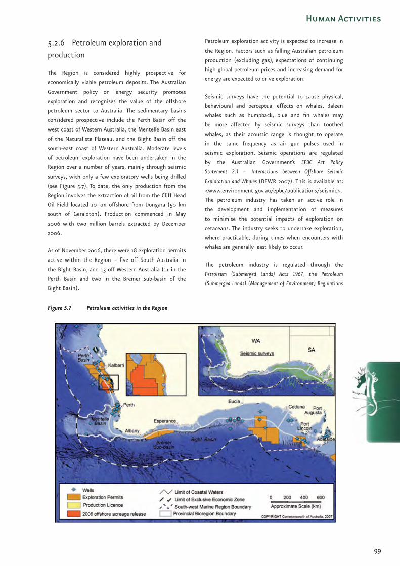
99
Human Activities
5.2.6 Petroleum exploration and
production
The Region is considered highly prospective for
economically viable petroleum deposits. The Australian
Government policy on energy security promotes
exploration and recognises the value of the offshore
petroleum sector to Australia. The sedimentary basins
considered prospective include the Perth Basin off the
west coast of Western Australia, the Mentelle Basin east
of the Naturaliste Plateau, and the Bight Basin off the
south-east coast of Western Australia. Moderate levels
of petroleum exploration have been undertaken in the
Region over a number of years, mainly through seismic
surveys, with only a few exploratory wells being drilled
(see Figure 5.7). To date, the only production from the
Region involves the extraction of oil from the Cliff Head
Oil Field located 10 km offshore from Dongara (50 km
south of Geraldton). Production commenced in May
2006 with two million barrels extracted by December
2006.
As of November 2006, there were 18 exploration permits
active within the Region – five off South Australia in
the Bight Basin, and 13 off Western Australia (11 in the
Perth Basin and two in the Bremer Sub-basin of the
Bight Basin).
Petroleum exploration activity is expected to increase in
the Region. Factors such as falling Australian petroleum
production (excluding gas), expectations of continuing
high global petroleum prices and increasing demand for
energy are expected to drive exploration.
Seismic surveys have the potential to cause physical,
behavioural and perceptual effects on whales. Baleen
whales such as humpback, blue and fin whales may
be more affected by seismic surveys than toothed
whales, as their acoustic range is thought to operate
in the same frequency as air gun pulses used in
seismic exploration. Seismic operations are regulated
by the Australian Government’s EPBC Act Policy
Statement 2.1 – Interactions between Offshore Seismic
Exploration and Whales (DEWR 2007). This is available at:
<www.environment.gov.au/epbc/publications/seismic>.
The petroleum industry has taken an active role in
the development and implementation of measures
to minimise the potential impacts of exploration on
cetaceans. The industry seeks to undertake exploration,
where practicable, during times when encounters with
whales are generally least likely to occur.
The petroleum industry is regulated through the
Petroleum (Submerged Lands) Acts 1967, the Petroleum
(Submerged Lands) (Management of Environment) Regulations
Figure 5.7 Petroleum activities in the Region

100
The
Sou
th-w
est
Mar
ine
Bio
regi
on
al P
lan
: B
iore
gio
nal
Pro
file 1999 and the EPBC Act. Best-practice and consistency
in environmental regulation across Australia is pursued
through the Environmental Assessors Forum and the
Standing Committee on Environmental Approval
Processes for Offshore Acreage. These fora provide
an avenue for regulators to engage industry and
conservation groups as required on relevant issues. Key
issues progressed through these groups, with high levels
of stakeholder consultation and agreement, include
the 2005 review of the Management of Environment
Regulations and the review of the Guidelines on the
Application of the Environment Protection and Biodiversity
Conservation Act to Interactions between Offshore Seismic
Operations and Larger Cetaceans (see also Appendix B).
A key feature of the Environment Regulations is the
requirement that an operator submit an Environment
Plan before commencing any petroleum activity. An
accepted Environment Plan establishes legally binding
environmental management conditions that must be
met by the operator of an offshore petroleum activity.
Seismic survey vessel for petroleum exploration. Photo: CGGVeritas.

101
Human Activities
5.2.7 Recreational use
The main recreational use currently undertaken in the
Region is offshore recreational fishing. Other important
recreational activities such as SCUBA diving are mostly
confined to inshore areas.
Recreational fishers of the Region target a range of
deep-water fish including snapper, samson fish, groper,
Australian salmon and tunas off Western Australia, and
tunas, striped marlin, snapper, Australian salmon and
trevally off South Australia. Major areas of activity
include waters off the Eyre Peninsula and Kangaroo
Island, and off Perth and the Capes Region (Figure
5.8). While no reliable figures exist on the extent of
fishing activity specifically within the South-west
Marine Region, in 2001 recreational fishers across the
whole of Western Australia and South Australia spent
the equivalent of about 436 000 days fishing within
‘offshore areas’. The distribution of fishing effort in
offshore areas differed markedly by State. In Western
Australia in 2001, over 11 per cent of fishing effort
(out of the total of 3.4 million fishing days reported by
Western Australian fishers) was carried out in offshore
areas, while in South Australia the figure was only three
per cent (of the 1.9 million reported fishing).
Given the south-west’s expanding population, the
continuing popularity of recreational fishing, the
increasing availability and affordability of sea-going
vessels and improvements in boating and fishing
technologies, it is likely that Commonwealth waters
will experience increasing growth in recreational fishing
activity.
Management of recreational fishing, both in State
waters and offshore areas is currently the responsibility
of the adjacent State. Both Western Australia and
South Australia have a range of management initiatives
in place including bag possession limits, size limits,
gear restrictions, seasonal closures and area closures.
Further information on the rules and regulations
applying to recreational fishing is available at
<www.pir.sa.gov.au/dhtml/ss/section.php?sectID=268>
and <www.fish.wa.gov.au/sec/rec/index.php>.
Figure 5.8 Distribution of recreational fishing effort (2001)
Note that the outer limits of recreational fishing effort shown on the map are indicative only and may not represent the actual range of recreational fishers within these areas – generally effort will occur closer to the coast.

102
The
Sou
th-w
est
Mar
ine
Bio
regi
on
al P
lan
: B
iore
gio
nal
Pro
file 5.2.8 Sea dumping
Prior to 1981, waste including vessels, ammunition and
chemicals were regularly dumped in the Region’s waters.
Today, little sea dumping occurs.
The marked reduction in sea dumping activity is due
to a range of regulatory measures introduced by the
Australian Government. The Beaches, Fishing Grounds and
Sea Routes Protection Act 1932 placed the first controls
on the dumping of obsolete vessels. The Act specified
that vessels could only be dumped in any one of four
designated areas in waters off South Australia and
Western Australia – two in State waters near Albany
and two in Commonwealth waters off the western tip of
Rottnest Island and off eastern Kangaroo Island. The Act
also prohibited the dumping of “any garbage, rubbish,
ashes or organic refuse” in designated exclusion zones.
While restrictions were placed on the location of
dumping of vessels, dumping of a range of harmful
chemicals and pollutants was still permitted, and
benzene, cyanide, pesticides and arsenic have been
disposed of in the Region’s waters. Following its
ratification of the London Convention of 1972, the
Australian Government enacted the Environment
Protection (Sea Dumping) Act 1981 to fulfil its obligations
as a signatory to convention. In 1996, the Sea Dumping
Act was amended to implement the 1996 Protocol to
the London Convention (ratified by Australia in 2000).
Under the Protocol, Australia prohibits ocean disposal
of waste materials considered harmful to the marine
environment, and regulates dumping of waste at sea to
minimise environmental impacts.
Within coastal waters, there is a low level of dumping mainly
involving the disposal of dredge spoil from port shipping
channels and berths to maintain clearance depths for
shipping. Decommissioned vessels are also dumped in shallow
water as diving attractions and artificial reefs (Figure 5.9).
The impact of past sea dumping on the conservation
values of the Region is unknown. Chemicals dumped
within the Region may pose some threat to the marine
environment. While no studies appear to have been
undertaken within the Region, limited studies on
chemical warfare agents disposed off Australia’s east
coast by Australian forces after World War II point to
minimal threat upon the marine environment except
within the immediate vicinity of a dump.
A permit is required under the Sea Dumping Act
to authorise the dumping, and the loading for the
purposes of dumping, of any wastes or other matter
into Australian waters, or from an Australian vessel or
platform, anywhere at sea. Further information on sea
dumping and legislative requirements is available at
<www.environment.gov.au/coasts/pollution/dumping>.
Figure 5.9 Sea dumping in the South-west Marine Region prior to the Environment Protection (Sea Dumping) Act 1981

103
Human Activities
5.2.9 Shipping and ports
Shipping is a vital industry for the Western and South
Australian economies. Ships transit through the Region
on the way to and from Australian ports adjacent to the
Region, the eastern seaboard of Australia and overseas
destinations. The main port of call in 2005-06 was the
Port of Fremantle, which recorded 1641 ship visits. The
next most important port destination was the Port
of Adelaide, with 1113 ship visits. In 2004, the total
number of commercial voyages within/through the
Region was 3861. Figure 5.10 shows the main routes
used by commercial shipping while within the Region.
The ports of Albany, Bunbury, Esperance and Geraldton
are important for the shipping of minerals and
agricultural commodities from Western Australia.
Important ports in South Australia include Port Lincoln,
Port Pirie, Thevenard and Whyalla. In Western Australia,
due to the strong commodity demand, all south coast
ports are undertaking expansions or port upgrades with
most of the ports experiencing record trade activity. In
addition, the resource boom has initiated planning for a
new port at Oakajee, north of Geraldton, to provide for
further iron ore exports.
Economic growth in Australia and overseas has led to
increasing ship movements related to the import and
export of commodities and goods, and the volume of
cargo shipped is likely to increase in the foreseeable
future. For example, container traffic is expected to rise
by 66 per cent on average across Australia by 2011.
The implications of increased maritime transport
activity include both the potential for higher rates of
interaction between vessels and protected species, and
an intensification of the potential threats associated
with shipping activities. Potential threats may include
oil spills, the introduction of marine pests through
ballast water exchange and bio-fouling, and the indirect
environmental effects of increased port use and port
expansion.
The environmental management of shipping is governed
by a range of national and international agreements,
regulations and codes of practice. In Australia, the
Protection of the Sea (Prevention of Pollution from Ships)
Act 1983 gives effect to the core provisions of the
international Convention for the Prevention of Pollution
from Ships 1973 (MARPOL). In relation to marine pests,
Australia has in place a range of initiatives under the
Australian Ballast Water Management Strategy. These set
a range of requirements regarding ballast water, where
it can be exchanged and how it must be treated.
Figure 5.10 Shipping routes within the Region

104
The
Sou
th-w
est
Mar
ine
Bio
regi
on
al P
lan
: B
iore
gio
nal
Pro
file 5.2.10 Submarine telecommunication
cables
Since 1901, there have been a total of five submarine
telecommunication cables laid in the Region. Today, only
one telecommunication cable, the SEA_ME_WE3 cable,
linking Australia, via Perth, with South-East Asia, is still
in use (Figure 5.11).
The SEA_ME_WE3 cable has recently been declared
a submarine cable of national significance under the
Telecommunications and Other Legislation Amendment
(Protection of Submarine Cables and Other Measures) Act 2005.
As a result, the Australian Communications and Media
Authority has declared a protection zone over the cable
to prohibit and/or restrict activities that may damage
the cable. The protection zone over the cable is two
nautical miles wide, and extends to a depth of 2000 m
(approximately 94.5 km from land).
While there are a range of regulations governing the
laying and protection of cables, the EPBC Act is the main
legislative instrument concerned with the environmental
impact of cables. Under the EPBC Act, any proposals for
submarine cables must be referred to the Minister for
the Environment, Heritage and the Arts for assessment
and approval if they are considered likely to have
a significant impact on the Commonwealth marine
environment or other matters of national environmental
significance.
Figure 5.11 Location of the SEA_ME_WE3 submarine cable

105
Human Activities
Key references and further readings
Australian Bureau of Agricultural and Resource Economics,
2006, Australian Fisheries Statistics 2005, ABARE, Canberra,
<www.abare.gov.au/publications_html/fisheries/
fisheries_06/AusFishStats_05.pdf>, accessed 07/05/2007.
Australian Institute of Aboriginal and Torres Strait
Islander Studies, 2006, Sea Countries of the South:
Indigenous Interests and Connections within the South-
west Marine Region of Australia, AIATSIS, Canberra,
<www.environment.gov.au/indigenous>.
Department of Primary Industries and Resources of
South Australia (PIRSA), 2007, South Australian Fisheries
Resources Current Status & Recent Trends 2006, PIRSA,
Adelaide, <www.pir.sa.gov.au/fisheries/products/
reference_books/sa_resources/6>, accessed 02/05/07.
Fletcher, W.J., & Head, F. (eds), 2006, State of the Fisheries
Report 2005/06, Department of Fisheries, Western
Australia, <www.fish.wa.gov.au/docs/sof/2005>,
accessed 07/05/07.
Gardner, S., Tonts, M., & Elrick, C., 2006, A Socio-
economic Analysis and Description of the Marine Industries of
Australia’s South-west Marine Region, Institute for Regional
Development, University of Western Australia, report for
the Department of the Environment & Water Resources,
Canberra, <www.environment.gov.au/coasts/mbp/
south-west>.
Geoscience Australia, 2004, Southern Region,
<www.ga.gov.au/oceans/rpg_SthrnAust.jsp>, accessed
04/12/2006.
McKay, W.J. Miezitis, Y., Exxon, N.F., & Sait, R., 2005
‘Australia’s offshore minerals: an overview’, in Yeats, C.J.
& McConachy, T.F. (eds), Deep Blue Minerals – Towards a
Sustainable Marine Minerals Industry: Extended Abstracts.
Workshop, Sydney 27 April 2005, CSIRO Exploration and Mining
Report P2005/135, 9-14.
McLoughlin, K. (ed), 2006, Fishery Status Reports
2005: Status of Fish Stocks Managed by the Australian
Government, Bureau of Rural Sciences, Department
of Agriculture, Fisheries and Forestry, Canberra,
<www.affashop.gov.au/product.asp?prodid=13611>,
accessed 07/05/07.
Plunkett, G., 2003a, Chemical Warfare Agent Sea Dumping
off Australia, Department of Defence, Canberra,
<www.hydro.gov.au/n2m/dumping/cwa/chemical.pdf>,
accessed 16/11/06.
Plunkett, G., 2003b, Sea dumping in Australia: Historical
and Contemporary Aspects, Department of Defence and
Department of the Environment and Heritage, Canberra.
Sait, R., 2001, ‘Appendix IV – Review of exploration
and mining for minerals’, in Barratt, D., Garvey, J., &
Chesson, J., 2001, Australia: State of the Environment Second
Technical Paper Series (Coasts and Oceans), Series 2, Bureau
of Resource Sciences Australia & Department of the
Environment and Heritage, Canberra.
Legislation
Available from Commonwealth of Australia Law website
<www.comlaw.gov.au>
Beaches, Fishing Grounds and Sea Routes Protection Act 1932
Environment Protection (Sea Dumping) Act 1981
Fisheries Management Act 1991
Native Title Act 1993
Offshore Minerals Act 1994
Petroleum (Submerged Lands) Act 1967
Petroleum (Submerged Lands) (Management of Environment)
Regulations 1999
Protection of the Sea (Prevention of Pollution from Ships) Act
1983
Telecommunications and Other Legislation Amendment
(Protection of Submarine Cables and Other Measures) Act 2005
International agreements
Convention on the Prevention of Marine Pollution by Dumping
of Wastes and Other Matter (London Convention) 1972,
<www.imo.org>, accessed 10/7/07.
1996 Protocol to the Convention on the Prevention of Marine
Pollution by Dumping of Wastes and Other Matter (London
Convention), <www.imo.org>, accessed 10/7/07.

106
The
Sou
th-w
est
Mar
ine
Bio
regi
on
al P
lan
: B
iore
gio
nal
Pro
file Policies & guidelines
Department of Agriculture Fisheries and Forestry (DAFF),
2000, National Policy on Fisheries Bycatch, DAFF, Canberra,
<www.daffa.gov.au/fisheries/environment/bycatch/
comm-policy>, accessed 07/05/07.
Department of the Environment and Heritage
(DEH), 2006, EPBC Act Policy Guidelines 2.2 Industry
Guidelines – Offshore Aquaculture, DEH, Canberra,
<www.environment.gov.au/epbc/publications/
aquaculture-policy.html>, accessed 07/05/07.
Department of the Environment and Heritage (DEH)
Natural Resource Management Ministerial Council,
2005, National Guidelines for Whale & Dolphin Watching,
DEH, Canberra, <www.environment.gov.au/coasts/
publications/whalewatching-guidelines-2005.html>
accessed 07/05/07.
Department of the Environment and Water
Resources (DEWR), 2007, EPBC Act Policy
Statement 2.1 – Interactions between Offshore
Seismic Exploration and Whales, DEWR, Canberra,
<www.environment.gov.au/epbc/publications/seismic>,
accessed 07/04/08.
Map data
Figure 5.1 Distribution of Aboriginal language groups in the south-westDepartment of the Environment, Water, Heritage and the Arts (2006):Commonwealth Marine Planning RegionsDepartment of the Environment, Water, Heritage and the Arts (2006):Integrated Marine and Coastal Regionalisation of Australia v4.0 - Provincial BioregionsGeoscience Australia (1998): Australia, TOPO-2.5M Topographic DataGeoscience Australia (2004): Gazetteer of AustraliaGeoscience Australia (2005): Australian Bathymetry and TopographyGeoscience Australia (2006): Australian Maritime Boundaries (AMB) v2.0South Australia Museum: Tindale Tribal BoundariesProjection: Geographics, Datum: GDA94Produced by the Environmental Resources Information Network (ERIN) Australian Government Department of the Environment, Water, Heritage and the Arts. COPYRIGHT Commonwealth of Australia, 2007.
Figure 5.2 Average annual population growth adjacent to the South-west Marine Region (2001-2006)Australian Bureau of Statistics (2007): Australia, Estimated Resident PopulationsDepartment of the Environment, Water, Heritage and the Arts (2006):Commonwealth Marine Planning RegionsDepartment of the Environment, Water, Heritage and the Arts (2006):Integrated Marine and Coastal Regionalisation of Australia v4.0 - Provincial BioregionsGeoscience Australia (1998): Australia, TOPO-2.5M Topographic DataGeoscience Australia (2004): Gazetteer of AustraliaGeoscience Australia (2005): Australian Bathymetry and TopographyGeoscience Australia (2006): Australian Maritime Boundaries (AMB) v2.0Projection: Geographics, Datum: GDA94Produced by the Environmental Resources Information Network (ERIN) Australian Government Department of the Environment, Water, Heritage and the Arts. COPYRIGHT Commonwealth of Australia, 2007.
Figure 5.4 South-west Marine Region all fisheries combined catch (2000-2002)Bureau of Resource Sciences (2005): National Atlas of Marine FisheriesDepartment of the Environment, Water, Heritage and the Arts (2006):Commonwealth Marine Planning RegionsDepartment of the Environment, Water, Heritage and the Arts (2006):Integrated Marine and Coastal Regionalisation of Australia v4.0 - Provincial BioregionsGeoscience Australia (1998): Australia, TOPO-2.5M Topographic DataGeoscience Australia (2004): Gazetteer of AustraliaGeoscience Australia (2005): Australian Bathymetry and TopographyGeoscience Australia (2006): Australian Maritime Boundaries (AMB) v2.0Projection: Geographics, Datum: GDA94Produced by the Environmental Resources Information Network (ERIN) Australian Government Department of the Environment, Water, Heritage and the Arts. COPYRIGHT Commonwealth of Australia, 2007.
Figure 5.5 Defence training areas within and adjacent to the RegionAustralian Hydrographic Services (2005): Notices to MarinersDepartment of the Environment, Water, Heritage and the Arts (2004): Submarine CablesDepartment of the Environment, Water, Heritage and the Arts (2006):Commonwealth Marine Planning RegionsDepartment of the Environment, Water, Heritage and the Arts (2006):Integrated Marine and Coastal Regionalisation of Australia v4.0 - Provincial BioregionsGeoscience Australia (1998): Australia, TOPO-2.5M Topographic DataGeoscience Australia (2004): Gazetteer of AustraliaGeoscience Australia (2005): Australian Bathymetry and TopographyGeoscience Australia (2006): Australian Maritime Boundaries (AMB) v2.0Projection: Geographics, Datum: GDA94Produced by the Environmental Resources Information Network (ERIN) Australian Government Department of the Environment, Water, Heritage and the Arts. COPYRIGHT Commonwealth of Australia, 2007.
Figure 5.6 Aquaculture production within and adjacent to the RegionAustralian Bureau of Statistics (2001): Australia, Census of Population and HousingDepartment of the Environment, Water, Heritage and the Arts (2006):Commonwealth Marine Planning RegionsDepartment of the Environment, Water, Heritage and the Arts (2006):Integrated Marine and Coastal Regionalisation of Australia v4.0 - Provincial BioregionsGeoscience Australia (1998): Australia, TOPO-2.5M Topographic DataGeoscience Australia (2004): Gazetteer of AustraliaGeoscience Australia (2005): Australian Bathymetry and TopographyGeoscience Australia (2006): Australian Maritime Boundaries (AMB) v2.0Department of Fisheries Western Australia: Aquaculture ZonesPrimary Industries and Resources South Australia: Aquaculture ZonesProjection: Geographics, Datum: GDA94Produced by the Environmental Resources Information Network (ERIN) Australian Government Department of the Environment, Water, Heritage and the Arts. COPYRIGHT Commonwealth of Australia, 2007.
Figure 5.7 Petroleum activities in the RegionDepartment of the Environment, Water, Heritage and the Arts (2006):Commonwealth Marine Planning RegionsDepartment of the Environment, Water, Heritage and the Arts (2006):Integrated Marine and Coastal Regionalisation of Australia v4.0 - Provincial BioregionsDepartment of the Environment, Water, Heritage and the Arts (2007):GPinfo Petroleum Exploration Database, Seismic SurveysGeoscience Australia (1998): Australia, TOPO-2.5M Topographic DataGeoscience Australia (2004): Gazetteer of AustraliaGeoscience Australia (2005): Australian Bathymetry and TopographyGeoscience Australia (2006): Australian Maritime Boundaries (AMB) v2.0Projection: Geographics, Datum: GDA94Produced by the Environmental Resources Information Network (ERIN) Australian Government Department of the Environment, Water, Heritage and the Arts. COPYRIGHT Commonwealth of Australia, 2007.
107
Human Activities
Figure 5.8 Distribution of recreational fishing effort (2001)Bureau of Resource Sciences (2001):Australian National Recreational and Indigenous Fishing Survey – Recreational Catch MappingDepartment of the Environment, Water, Heritage and the Arts (2006):Commonwealth Marine Planning RegionsDepartment of the Environment, Water, Heritage and the Arts (2006):Integrated Marine and Coastal Regionalisation of Australia v4.0 - Provincial BioregionsGeoscience Australia (1998): Australia, TOPO-2.5M Topographic DataGeoscience Australia (2004): Gazetteer of AustraliaGeoscience Australia (2005): Australian Bathymetry and TopographyGeoscience Australia (2006): Australian Maritime Boundaries (AMB) v2.0Projection: Geographics, Datum: GDA94Produced by the Environmental Resources Information Network (ERIN) Australian Government Department of the Environment, Water, Heritage and the Arts. COPYRIGHT Commonwealth of Australia, 2007.
Figure 5.9 Sea dumping in the South-west Marine Region prior to the Environment Protection (Sea Dumping) Act 1981Department of the Environment, Water, Heritage and the Arts (1998): Sea Dumped Waste Material off Australia and its TerritoriesDepartment of the Environment, Water, Heritage and the Arts (2006):Commonwealth Marine Planning RegionsDepartment of the Environment, Water, Heritage and the Arts (2006):Integrated Marine and Coastal Regionalisation of Australia v4.0 - Provincial BioregionsGeoscience Australia (1998): Australia, TOPO-2.5M Topographic DataGeoscience Australia (2004): Gazetteer of AustraliaGeoscience Australia (2005): Australian Bathymetry and TopographyGeoscience Australia (2006): Australian Maritime Boundaries (AMB) v2.0Projection: Geographics, Datum: GDA94Produced by the Environmental Resources Information Network (ERIN) Australian Government Department of the Environment, Water, Heritage and the Arts. COPYRIGHT Commonwealth of Australia, 2007.
Figure 5.10 Shipping routes within the RegionBureau of Resource Sciences (2004): Shipping Routes and Traffic in the South-west Marine RegionDepartment of the Environment, Water, Heritage and the Arts (2006):Commonwealth Marine Planning RegionsDepartment of the Environment, Water, Heritage and the Arts (2006):Integrated Marine and Coastal Regionalisation of Australia v4.0 - Provincial BioregionsGeoscience Australia (1998): Australia, TOPO-2.5M Topographic DataGeoscience Australia (2004): Gazetteer of AustraliaGeoscience Australia (2005): Australian Bathymetry and TopographyGeoscience Australia (2006): Australian Maritime Boundaries (AMB) v2.0Projection: Geographics, Datum: GDA94Produced by the Environmental Resources Information Network (ERIN)Australian Government Department of the Environment, Water, Heritage and the Arts. COPYRIGHT Commonwealth of Australia, 2007.
Figure 5.11 Location of the SEA_ME_WE3 submarine cableDepartment of the Environment, Water, Heritage and the Arts (2004): Submarine CablesDepartment of the Environment, Water, Heritage and the Arts (2006):Commonwealth Marine Planning RegionsDepartment of the Environment, Water, Heritage and the Arts (2006):Integrated Marine and Coastal Regionalisation of Australia v4.0 - Provincial BioregionsGeoscience Australia (1998): Australia, TOPO-2.5M Topographic DataGeoscience Australia (2004): Gazetteer of AustraliaGeoscience Australia (2005): Australian Bathymetry and TopographyGeoscience Australia (2006): Australian Maritime Boundaries (AMB) v2.0Projection: Geographics, Datum: GDA94Produced by the Environmental Resources Information Network (ERIN) Australian Government Department of the Environment, Water, Heritage and the Arts. COPYRIGHT Commonwealth of Australia, 2007.
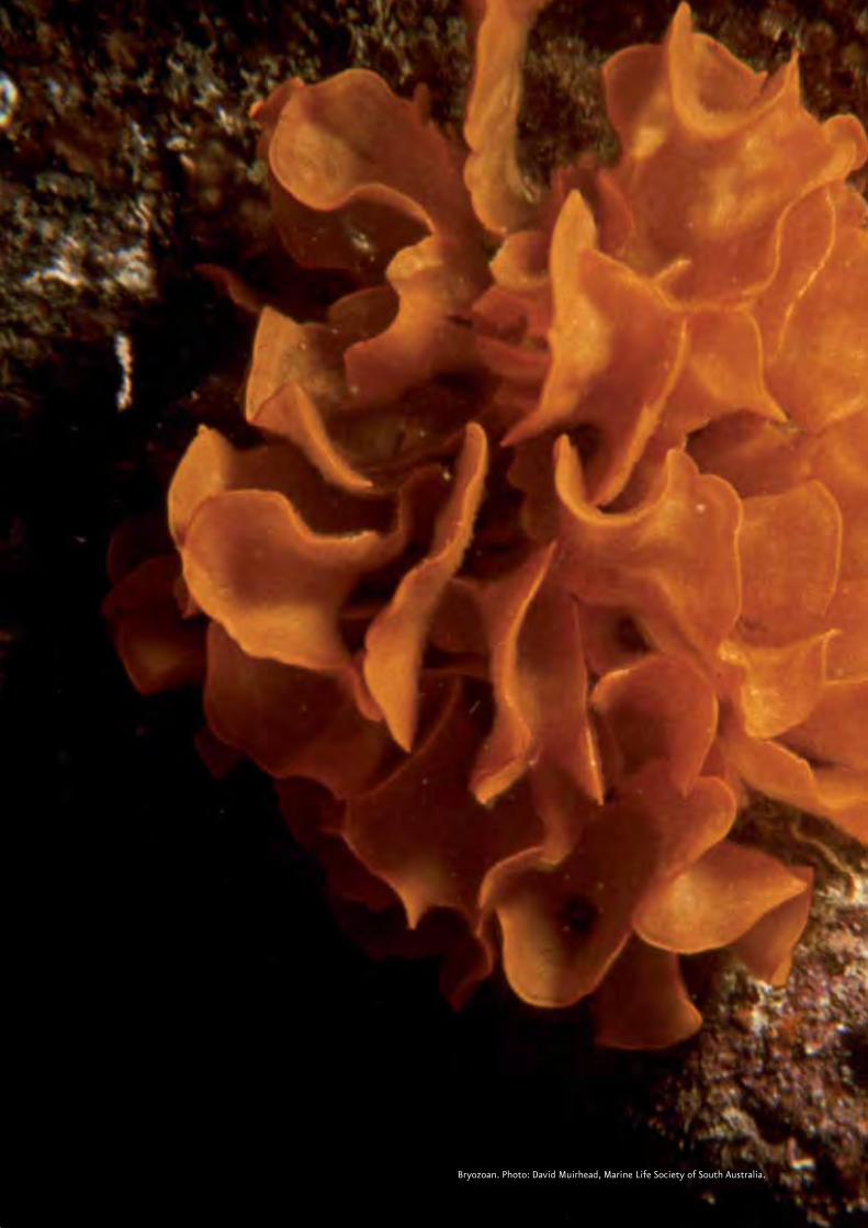
108Bryozoan. Photo: David Muirhead, Marine Life Society of South Australia.

109
Next Steps
Chapter 6 Developing a South-west Marine Bioregional Plan: Next Steps
The environment of the South-west Marine Region
experiences relatively little pressure from human
activities in comparison to many other parts of the ocean
in Australia and elsewhere. Large areas of the Region
are remote, with human development concentrated in
relatively restricted stretches of the coast. However,
human activities over the last 200 years have had an
impact on the marine environment of the South-west
Marine Region. For instance, it is possible that intensive
harvesting of seals, whales, large pelagic fish and sharks
may have changed the relative distribution of species and
altered ecologically important relationships between prey
and predators.
The economies of the States of South Australia and
Western Australia are predicted to experience substantial
growth over the coming years. This will be driven
primarily by growth in the onshore mining and offshore
petroleum sectors, prompted by increasing demand
from the fast-growing economies of Asia. The growth
in these sectors together with growth in supporting
services and infrastructure sectors and the populations
of coastal centres is likely to result in increasing human
interactions with the conservation values of the South-
west Marine Region.
This Bioregional Profile provides a snapshot of what we
know about the environment of the South-west Marine
Region and the ways in which we use it. This Bioregional
Profile and supporting reports (see Chapter 1.2) provide
an information-base for the next stages (Figure 6.1) of
marine bioregional planning in the south-west. While
the Department of the Environment, Water, Heritage
and the Arts has endeavoured to ensure that the
information in this Bioregional Profile is comprehensive,
up to date and accurate, we recognise that stakeholders
may have additional information that will contribute
to our understanding of the Region. The Department
welcomes comments on the Bioregional Profile and any
additional information that may assist in developing
a Marine Bioregional Plan for the South-west Marine
Region.
Comments and additional information can be sent by
email to:
or by post to :
The Director, South Planning Section
National Oceans Office Branch
Department of the Environment, Water, Heritage and
the Arts
Edgar Waite Building
203 Channel Highway
Kingston Tasmania 7050
All information provided will be considered by the
Department in developing the Draft South-west Marine
Bioregional Plan.
The next phase of the planning process will involve
developing the Draft South-west Marine Bioregional Plan
under Section 176 of the EPBC Act. Developing the Draft
Plan will entail:
identifying conservation priorities for the Region;
identifying appropriate measures available to
Government to address the conservation priorities;
and
developing a network of representative marine
protected areas (MPAs) for the Region.
•
•
•
A ghost shark swims over fine sediment bottom. Southwest Transition, 385 m deep. Photo: CSIRO.

110
The
Sou
th-w
est
Mar
ine
Bio
regi
on
al P
lan
: B
iore
gio
nal
Pro
file The Department of the Environment, Water, Heritage
and the Arts will consult stakeholders and interested
parties in developing the Draft Plan and, in particular,
will seek their input on:
the conservation values identified in this
Bioregional Profile;
the identification of conservation priorities;
the identification of MPAs, and
the social and economic implications of proposed
conservation measures, including possible MPAs.
Further information about how you can be involved in
the development of the South-west Marine Bioregional
Plan is available on the Department’s website at
<www.environment.gov.au/coasts/mbp/south-west>.
•
•
•
•
Following the release of the Draft South-west Marine
Bioregional Plan there will also be a statutory
consultation period. At least 60 days will be provided for
public comment on the Draft Plan. During this period,
the Department of the Environment, Water, Heritage
and the Arts will facilitate meetings with stakeholders
to discuss and clarify specific issues and comments. After
considering comments and any additional information
provided, the Department will finalise the Plan for
consideration and approval by the Minister for the
Environment, Heritage and the Arts.
Rainbow cale. Photo: Marine Life Society of South Australia.

111
Next Steps
Figure 6.1 Stages of marine bioregional planning in the South-west

112
Diver on the wreck of HMAS Swan in Geographe Bay. Photo : Glen Cowans.

113
International Conventions and Agreements
Appendix A International Conventions and Agreements on the Marine Environment
Australia’s use and management of its oceans and their
resources are subject to a range of international treaties
to which Australia is a party. These can be broadly
divided into two categories: those concerned with
regulating activities to protect the marine environment
and those relating specifically to the conservation of
biodiversity. The following sections outline the main
international agreements that influence Australia’s
approach to conserving marine biodiversity and
protecting the marine environment.
Australia also recently became a Contracting Party
to the International Convention on the Control of
Harmful Anti-fouling Systems on Ships, 2001. The
convention will enter into force in Australia when
it enters into force internationally.
Australia has also signed, subject to ratification,
two other international agreements which regulate
activities to protect the marine environment and
which are not yet in force:
the International Convention for the Control
and Management of Ships’ Ballast Water and
Sediments, 2004; and
the International Convention on Civil Liability
for Bunker Oil Pollution Damage, 2001.
International agreements regulating maritime activities to protect the marine environment
United Nations Convention on the Law of
the Sea (UNCLOS) 1994
The Australian Government has rights and
responsibilities under the United Nations Convention
on the Law of the Sea 1994 (UNCLOS) to manage seas
adjacent to its coastline. Under UNCLOS, coastal states
are able to claim rights and responsibilities for seas out
to 200 nautical miles from the coast, and to the edge
of the continental shelf. Within this area coastal nations
can exploit, develop, manage and conserve all resources
(associated with the water column, seabed or subsoil).
Under UNCLOS, all parties have an obligation to protect
and preserve the marine environment.
•
•
•
•
Agreement for the Implementation of the
Provisions of the United Nations Convention
on the Law of the Sea of 10 December
1982 relating to the Conservation and
Management of Straddling Fish Stocks and
Highly Migratory Fish Stocks 1995 (Fish
Stocks Agreement)
This implementing agreement to UNCLOS provides
additional and enhanced rules on the conservation and
management of highly migratory fish stocks and those
that straddle the high seas and areas within national
jurisdiction. The Fish Stocks Agreement promotes
cooperation with other States Parties, particularly
through the establishment of regional fisheries
management bodies. The Fish Stocks Agreement also
includes application of the precautionary approach
and requires consideration of impacts on the broader
ecosystem.
Convention relating to Intervention on
the High Seas in Cases of Oil Pollution
Casualties 1969 and the 1973 Protocol to the
Convention
This convention affirms the right of coastal states
to take such measures on the high seas as may be
necessary to prevent, mitigate or eliminate danger to
their coastline or related interests from pollution by
oil or the threat thereof, following upon a maritime
casualty. The 1973 Protocol extended the convention to
cover substances other than oil.
Convention on the Prevention of Marine
Pollution by Dumping of Wastes and Other
Matter (London Convention) 1972 and the
1996 Protocol to the Convention
Under this convention, dumping is defined as deliberate
disposal of wastes or other matter in the sea that do
not constitute normal operations. In Australia, the
convention has been updated by the 1996 Protocol
to the convention (the London Protocol), which
Australia ratified in 2000, and which entered into force
internationally in 2006. The convention is implemented

114
The
Sou
th-w
est
Mar
ine
Bio
regi
on
al P
lan
: B
iore
gio
nal
Pro
file in Australia under the Environment Protection and
Biodiversity Conservation Act 1999 (EPBC Act) and the
Environment Protection (Sea Dumping) Act 1981, which have
been amended to reflect the London Protocol. These
Acts require permits to be issued for the dumping of
materials at sea.
Convention Concerning the Protection of the
World Cultural and Natural Heritage (World
Heritage Convention) 1972
This convention, which came into force in 1975, provides
for the protection of the world’s cultural and natural
heritage places. The convention is administered by the
World Heritage Committee whose functions are to:
identify nominated cultural and natural properties
of outstanding universal value, which are to be
protected under the convention and to list them on
the World Heritage List;
decide if properties on the list should be inscribed
on the List of World Heritage in Danger; and
determine how and under what conditions the
World Heritage Fund can be used to assist countries
in the protection of their World Heritage property.
Under the EPBC Act, the Commonwealth has the power
to submit properties for inclusion on the World Heritage
List. This may be exercised if the Minister for the
Environment, Heritage and the Arts is satisfied that the
Commonwealth has endeavoured to reach agreement
on the listing and management arrangements for
the property with both the owner or occupier of the
property as well as the State or Territory Government in
which the property is located.
International Convention for the Prevention
of Pollution from Ships 1973/78 (MARPOL)
Under the terms of this convention regulatory controls
were placed on pollution from ships. The convention has
six annexes that specifically address different sources of
pollution from shipping:
Annex I addresses the discharge of oil from ships
and regulates how and when a ship may discharge
oil into the sea;
Annex II addresses the discharge or escape of
noxious liquid substances (i.e. chemicals);
Annex III addresses harmful substances carried in
packaged forms (i.e. freight containers);
•
•
•
•
•
•
Annex IV addresses the discharge of sewage from
ships;
Annex V addresses discharge of garbage from ships
into the sea; and
Annex VI addresses air pollution from ships,
including engine emissions.
International Convention on Oil Pollution
Preparedness, Response and Cooperation
1990
This convention facilitates international cooperation
to prepare for and respond to major oil pollution
incidents and encourages countries to develop and
maintain an adequate capability to deal with oil
pollution emergencies. In Australia the provisions of
the convention are given effect through administrative
arrangements of the Australian Maritime Safety
Authority and other Government agencies.
International Convention on Civil Liability
for Oil Pollution Damage 1969
This convention requires oil tankers to have compulsory
insurance against pollution damage liabilities. The
convention applies to an oil spill occurring in the
Australian Exclusive Economic Zone (EEZ), and sets the
upper limits of liability, which depend on the size of the
vessel.
International Convention on the
Establishment of an International Fund for
Compensation for Oil Pollution Damage 1992
This convention applies if the cost for a clean-up of an
oil spill exceeds the upper limit of liability set under the
International Convention on Civil Liability for Oil Pollution
Damage 1969. Under the convention, oil companies are
required to be parties to pay damages and to cover the
clean-up costs of oil spills.
Regional Fisheries Management Organisations
The Australian Government Department of Agriculture,
Fisheries and Forestry develops policies and programmes
to address Australia’s international rights and
obligations, and represents Australia’s interests in a
number of international fora. Chief amongst these are
•
•
•

115
International Conventions and Agreements
Regional Fisheries Management Organisations, which are
established to govern the management of fish stocks.
Commission for the Conservation of Southern
Bluefin Tuna 1994
The convention for the Conservation of Southern
Bluefin Tuna formalised the voluntary management
arrangements between Australia, Japan and New
Zealand that had been established on a voluntary
basis. The convention created the Commission for the
Conservation of Southern Bluefin Tuna (CCSBT). The
Republic of Korea and the Fishing Entity of Taiwan have
since joined the commission. Cooperating Non-Members
participate fully in the business of the CCSBT but cannot
vote. Since 2003 the Philippines, South Africa and the
European Community have been formally accepted as
Cooperating Non-Members. The commission establishes
binding conservation and management measures for
the Southern Bluefin Tuna Fishery, including a total
allowable catch and national allocations. A range of
monitoring, control and surveillance measures are being
developed by the commission. The commission also
considers issues related to the impact of the fishery on
ecologically related species.
Indian Ocean Tuna Commission 1993
The Agreement for the Establishment of the Indian
Ocean Tuna Commission (IOTC), in force since 1996,
promotes cooperation in the conservation of tuna
and tuna-like species in the Indian Ocean, including
within areas of national jurisdiction for coastal states
(including Australia). The commission promotes their
optimum utilisation, and the sustainable development
of the fisheries. The IOTC has deferred management of
the Southern Bluefin Tuna Fishery to the CCSBT where
they are located in its area of competence. The IOTC
currently has 26 Members which are the coastal states
of the region and distant water fishing nations.
Other fisheries arrangements
Australia also participates in a number of fora that aim
to promote regional development through sustainable
fisheries management. These include:
the FAO, through its Committee on Fisheries;
the Asia-Pacific Economic Cooperation (APEC)
Fisheries Working Group; and
•
•
Pacific Fisheries Fora, including Australia’s
involvement in the Pacific Island Countries-US
Treaty.
To promote regional fisheries cooperation, Australia
maintains a strong and productive dialogue with its
close neighbours. Australia conducts bilateral meetings
with its neighbours to tackle issues such as shared
and highly migratory fish stock management, illegal,
unreported and unregulated fishing, and aquaculture
development. There are also a number of bilateral
agreements or arrangements between Australia and
neighbouring countries to ensure the sustainable use of
shared resources. The neighbouring countries with which
Australia shares cooperative ties include Indonesia, East
Timor, Papua New Guinea (including Torres Strait issues),
and New Zealand.
There are also several overarching multilateral
agreements and arrangements to which Australia is a
signatory or a party. These include:
United Nations Convention on the Law of the Sea 1994
(UNCLOS);
Agreement for the Implementation of the Provisions
of the United Nations Convention on the Law of the
Sea of 10 December 1982 relating to the Conservation
and Management of Straddling Fish Stocks and Highly
Migratory Fish Stocks (UN Fish Stocks Agreement);
United Nations Food and Agriculture Organisation’s (FAO)
Code of Conduct for Responsible Fisheries; and
Agreement to Promote Compliance with International
Conservation and Management Measures by Fishing
Vessels on the High Seas (Compliance Agreement).
International Agreements for the conservation of biodiversity
International Convention for the Regulation
of Whaling 1946
The International Convention for the Regulation of
Whaling was signed on 2 December 1946. The purpose
of the convention was “to provide for the proper
conservation of whale stocks and thus make possible
the orderly development of the whaling industry”. Over
the decades, most member countries have abandoned
whaling, but have continued to view the International
Whaling Commission (IWC) as the best forum to focus
on the conservation of whales. For over 26 years the
Australian Government has pursued, through the IWC, a
•
•
•
•
•

116
The
Sou
th-w
est
Mar
ine
Bio
regi
on
al P
lan
: B
iore
gio
nal
Pro
file permanent international ban on commercial whaling and
worldwide protection for all cetaceans.
Convention on International Trade in
Endangered Species of Wild Fauna and Flora
1973 (CITES)
This convention aims to ensure that international trade
in specimens of wild animal and plant species does not
threaten their survival. CITES works by providing a
legally binding framework whereby parties adopt their
own legislation to implement CITES measures at the
national level. The convention also allows parties to
adopt national legislation that is stricter than CITES
measures.
All international trade – imports, exports, re-exports and
introduction – of species listed under the convention
is controlled through a licensing system. The species
covered by CITES are listed in three Appendices,
according to the degree of protection they require.
Appendix I includes species threatened with extinction.
Trade in specimens of these species is permitted only in
exceptional circumstances. Appendix II includes species
not necessarily threatened with extinction, but in which
trade must be controlled to avoid exploitation that could
threaten their survival. Appendix III lists species that are
protected in at least one country, which has asked other
CITES parties for assistance in controlling the trade.
Bilateral Migratory Bird Agreements
For nearly 30 years, Australia has played an important
role in international cooperation to conserve migratory
birds in the East Asian-Australasian Flyway, which
stretches from Alaska and the east of Russia, through
the countries of East and South-East Asia, to Australia
and New Zealand. Australia has negotiated and entered
into bilateral agreements with Japan, China and Korea
to protect migratory birds. These are:
The Agreement between the Government of Australia and
the Government of Japan for the Protection of Migratory
Birds in Danger of Extinction and their Environment, 1974
(JAMBA);
The Agreement between the Government of Australia and
the Government of the People’s Republic of China for the
Protection of Migratory Birds and their Environment,
1986 (CAMBA); and
The Republic of Korea-Australia Migratory Bird Agreement
2006 (ROKAMBA).
•
•
•
The Partnership for the Conservation of Migratory Waterbirds
and the Sustainable Use of their Habitats in the East Asian
– Australasian Flyway, launched in Bogor, Indonesia on 6
November 2006, represents an important new step in
international efforts to conserve migratory waterbirds
and their habitats in the flyway. Established as a Type
II Partnership initiative of the 2002 World Summit
on Sustainable Development, the partnership is the
major international framework for the conservation of
migratory waterbirds in the East Asian – Australasian
Flyway, promoting dialogue, cooperation and
collaboration between stakeholders. To date, the
partnership has been endorsed by 17 governments and
organisations.
Convention on the Conservation of Migratory
Species of Wild Animals 1979
The convention on the Conservation of Migratory
Species of Wild Animals (also known as the CMS or
Bonn Convention) aims to conserve terrestrial, marine
and avian migratory species throughout their range.
The CMS has two Appendices. Appendix I lists migratory
species that have been categorised as being in danger of
extinction throughout all or a significant portion of their
range. Appendix II is for migratory species that have an
unfavourable conservation status and would benefit
significantly from international cooperation. For species
listed under Appendix I, signatory nations strive to take
action to protect these animals, conserve or restore the
places where they live, mitigate obstacles to migration
and control other factors that might endanger them.
For species listed under Appendix II, the convention
encourages the development of regional conservation
instruments.
Since becoming a party to the CMS in 1991, Australia
has been an active participant in implementing the
convention through the development of regional
conservation instruments under the CMS. Australia
played a key role in the development of the Agreement
for the Conservation of Albatross and Petrels (ACAP) and
the Indian Ocean and South-East Asian Memorandum of
Understanding for Sea Turtles IOSEA-Turtles), and has
significantly supported their implementation since they
have been finalised. For instance, Australia has hosted
the interim Secretariat of ACAP since its inception and
the headquarters will be established in Australia in due
course. Australia has also taken the lead in progressing
the development of new regional conservation
arrangements for marine mammals in the South Pacific.
All species listed under the CMS that naturally occur

117
International Conventions and Agreements
in Australia are listed under the EPBC Act and thereby
protected.
Convention on Biological Diversity 1992
Australia is a signatory to the Convention on Biological
Diversity, which was made at the 1992 Earth Summit
in Rio de Janeiro. The convention establishes three
main goals: the conservation of biological diversity,
the sustainable use of its components, and the fair
and equitable sharing of the benefits from the use
of genetic resources. A significant provision of the
Convention on Biological Diversity is the requirement
that environmental impact assessments be performed
for proposed activities likely to have significant
adverse impacts on the environment. The EPBC Act is
the mechanism by which the Australian Government
undertakes this provision of the Convention on
Biological Diversity.
Convention on the Conservation of Antarctic
Marine Living Resources 1980
This convention was established in response to concerns
that an increase in krill catches in the Southern Ocean
could have a serious negative impact on populations of
krill and other marine life; particularly on birds, seals
and fish, which mainly depend on krill for food. The aim
of the convention is:
to conserve marine life of the Southern Ocean by
ensuring that all harvesting and research activities
are conducted in accordance with the convention;
to formulate, adopt and revise conservation
measures;
to compile, analyse and disseminate information on
the status of resources; and
to facilitate research activities.
Convention for the Conservation of Antarctic
Seals 1972
The convention was set up to protect all six species of
seal found in the Antarctic, following concerns about a
possible resumption of commercial sealing in the region
in the mid-1960s. Commercial sealing has not resumed
in the Antarctic.
•
•
•
•
A scampi at the mouth of its burrow in fine sediments. Central Western Province, 408 m deep. Photo: CSIRO.

118
The
Sou
th-w
est
Mar
ine
Bio
regi
on
al P
lan
: B
iore
gio
nal
Pro
file Key references and further
readingsAgreement Between the Government of Australia and the
Government of Japan for the Protection of Migratory Birds in
Danger of Extinction and their Environment, 1974 (JAMBA),
<www.environment.gov.au/biodiversity/migratory>,
accessed 10/05/07.
Agreement Between the Government of Australia and the
Government of the People’s Republic of China for the Protection
of Migratory Birds and their Environment, 1986 (CAMBA),
<www.environment.gov.au/biodiversity/migratory>,
accessed 10/05/07.
Agreement for the Establishment of the Indian Ocean Tuna
Commission 1993, <www.iotc.org>, accessed 10/05/07.
Agreement for the Implementation of the Provisions of the United
Nations Convention on the Law of the Sea of 10 December 1982
Relating to the Conservation and Management of Straddling
Fish Stocks and Highly Migratory Fish Stocks 1995 (UN Fish
Stocks Agreement.) <www.un.org/Depts/los>, accessed
10/05/07.
Agreement to Promote Compliance with International
Conservation and Management Measures by Fishing
Vessels on the High Seas 1995 (Compliance Agreement),
<www.fao.org/fi>, accessed 10/05/07.
Code of Conduct for Responsible Fisheries 1995,
<www.fao.org/fi>, accessed 10/05/07.
Convention Concerning the Protection of the World Cultural
and Natural Heritage 1972 (World Heritage Convention),
<whc.unesco.org/en/conventiontext>, accessed 10/05/07.
Convention for the Conservation of Antarctic Seals 1972,
<www.unep.ch/regionalseas/legal/ccas.htm>, accessed
10/05/07.
Convention on Biological Diversity 1992, < www.biodiv.org>,
accessed 10/05/07.
Convention on International Trade in Endangered Species of Wild
Fauna and Flora 1973 (CITES), <www.cites.org>, accessed
10/05/07.
Convention on the Conservation of Antarctic Marine Living
Resources 1982, <www.ccamlr.org>, accessed 10/05/07.
Convention on the Conservation of Migratory Species of Wild
Animals 1979, <www.cms.int>, accessed 10/05/07.
Convention for the Conservation of Southern Bluefin Tuna 1994,
<www.ccsbt.org>, accessed 10/05/07.
Convention on the Prevention of Marine Pollution by Dumping
of Wastes and Other Matter 1972 (London Convention),
<www.imo.org>, accessed 10/7/07.
Convention Relating to Intervention on the High Seas in Cases
of Oil Pollution Casualties 1969, <www.imo.org>, accessed
10/05/07.
International Convention for the Prevention of Pollution from
Ships 1973/78 (MARPOL 73/78), <www.imo.org>, accessed
10/05/07.
International Convention for the Regulation of Whaling 1946,
<www.iwcoffice.org/commission/convention.htm>,
accessed 10/05/07.
International Convention on Civil Liability for Oil Pollution
Damage 1969, <www.imo.org>, accessed 10/05/07.
International Convention on Oil Pollution Preparedness,
Response and Cooperation 1990, < www.imo.org>, accessed
10/05/07.
International Convention on the Establishment of an
International Fund for Compensation for Oil Pollution Damage
1992, < www.imo.org>, accessed 10/05/07.
Republic of Korea – Australia Migratory Bird Agreement
(ROKAMBA) 2006, <www.environment.gov.au/
biodiversity/migratory/waterbirds>, accessed 10/08/07.
Treaty on Fisheries Between the Governments of Certain
Pacific Island States and the Government of the United States
of America 1987 (Pacific Island Countries-US Treaty),
<www.daffa.gov.au/fisheries/international/multilateral/
pacific-ocean-fora>, accessed 10/05/07.
United Nations Convention on the Law of the Sea 1994
(UNCLOS), <www.un.org/Depts/los>, accessed
10/05/07.

119
International Conventions and Agreements

120Sponge crab. Photo: Marine Life Society of South Australia.

121
Overview of the Legislative Framework
Appendix B An Overview of the Legislative Framework for Environmental Protection and Biodiversity Conservation in Commonwealth Waters
The Environment Protection and Biodiversity Conservation
Act 1999 (EPBC Act) streamlines national environmental
assessment and approvals processes, protects Australian
biodiversity and integrates the management of
important natural and cultural places. Alongside the
EPBC Act, the Environment Protection (Sea Dumping) Act
1981 (Sea Dumping Act) and the Historic Shipwrecks Act
1976 are the main pieces of legislation that give effect
to the Australian Government’s responsibilities to protect
and conserve the environmental and heritage assets that
exist in Commonwealth waters. Like the EPBC Act, these
Acts are also the responsibility of the Minister for the
Environment, Heritage and the Arts.
Other key pieces of legislation and regulations that
include provisions for the protection of the environment
are the Petroleum (Submerged Lands) (Management of
Environment) Regulations 1999, made under the Petroleum
(Submerged Lands) Act 1967, the Fisheries Management
Act 1992, the Great Barrier Reef Marine Park Act 1975, the
Protection of the Sea (Prevention of Pollution from Ships) Act
1983 and the Sea Installations Act 1987. In addition, the
Native Title Act 1993 interacts with the EPBC Act in areas
of environmental protection.
Appendix B summarises the legislative context in which
marine bioregional planning takes place.
The EPBC Act
Marine bioregional planning
Marine Bioregional Plans are being developed for the
Commonwealth marine area under Section 176 of the
EPBC Act. The Commonwealth marine area generally
stretches from three nautical miles to 200 nautical miles
from the coast. See Box B1 for more information on the
Commonwealth marine area.
The States and the Northern Territory are responsible
for managing the marine environment in State and
Northern Territory coastal waters. Coastal waters are
a belt of water between the territorial sea baseline
(normally the low water mark along the coast) and a
line three nautical miles seaward of the territorial sea
baseline. As many ecological processes occur across
both State and Commonwealth waters, the Australian
Government aims to work cooperatively with the
States and the Northern Territory in developing and
implementing Marine Bioregional Plans.
Marine Bioregional Plans will bring together
comprehensive information and provide guidance to
sectoral managers and industry in relation to decisions
made under the EPBC Act about key conservation issues
and priorities in each marine region. The EPBC Act
requires the Minister for the Environment, Heritage and
the Arts to have regard, where relevant, to Bioregional
Plans when making decisions under the EPBC Act.
Marine Bioregional Plans also aim to streamline
conservation and environmental management, and to
create marine protected areas (MPAs) in Commonwealth
waters that will further the development of the National
Representative System of MPAs.
The marine bioregional planning programme is being
undertaken by the Department of the Environment,
Water, Heritage and the Arts in consultation with all
Commonwealth agencies responsible for marine-based
activities, and with input from stakeholders.
Referral, assessment and approval
Central to the EPBC Act is the concept of matters
of national environmental significance. Matters of
national environmental significance ‘trigger’ the referral,
assessment and approval of activities under the EPBC
Act. The EPBC Act requires that proposals for actions
that have, will have, or are likely to have a significant
impact on a matter of national environmental
significance must be referred to the Minister for the
Environment, Heritage and the Arts for assessment
and approval. This occurs unless some other provision
of the EPBC Act allows the action to be taken without
assessment and approval.

122
The
Sou
th-w
est
Mar
ine
Bio
regi
on
al P
lan
: B
iore
gio
nal
Pro
file The EPBC Act identifies seven matters of national
environmental significance:
World Heritage properties;
National Heritage places (from 1 January 2004);
Ramsar wetlands of international significance;
listed threatened species and ecological
communities (excluding species listed as extinct or
conservation dependent);
listed migratory species;
the marine environment; and
nuclear actions (including uranium mining).
Of these, three are particularly relevant to marine
bioregional planning: listed threatened species, listed
migratory species and the marine environment.
A number of EPBC Act Policy Statements have been
developed to provide guidance on when actions should
be referred to the Minister for the Environment,
Heritage and the Arts for a decision on whether
assessment and approval is required under the EPBC
Act. The following EPBC Act Policy Statements provide
guidance about the types of actions that should be
referred for assessment and approval:
EPBC Act Policy Statement 1.1 Significant Impact
Guidelines – Matters of National Environmental
Significance (May 2006). These provide proponents
of activities in the Commonwealth marine area
with guidance about whether or not the actions
they propose to take will require assessment and
approval under the EPBC Act;
EPBC Act Policy Statement 1.2 Significant Impact
Guidelines – Actions on, or Impacting upon,
Commonwealth Land and Actions by Commonwealth
Agencies (May 2006). These provide guidance on
land-based actions which should be referred for
•
•
•
•
•
•
•
•
•
approval under the EPBC Act and should be read
in conjunction with the EPBC Act Policy Statement
1.1 Significant Impact Guidelines – Matters of National
Environmental Significance;
Draft EPBC Act Policy Statement 2.1 – Interactions
Between Offshore Seismic Exploration and Whales (March
2007). This Draft EPBC Act Policy Statement updates
the previous cetacean interaction guidelines,
produced in 2001. The policy will be implemented
immediately, with a view to refinement based
on operational experience and public and expert
comments. The policy statement will be available
for public comment until 31 August 2007. It has
been prepared to: 1) provide practical standards to
minimise the risk of acoustic injuries to whales in
the vicinity of seismic survey operations; 2) provide
a framework that minimises the risk of biological
consequences from acoustic disturbance from
seismic surveys to whales in biologically important
habitat areas or during critical behaviours; and 3)
provide advice to proponents of offshore seismic
operations on their legal responsibilities under the
EPBC Act;
EPBC Act Policy Statement 2.2 Industry Guidelines
– Offshore Aquaculture (August 2006) These provide
guidance to proponents of marine aquaculture
activities to determine whether or not the actions
they propose will require assessment and approval
under the EPBC Act. These guidelines should be read
in conjunction with the EPBC Act Policy Statement
1.1 Significant Impact Guidelines – Matters of National
Environmental Significance; and
Nationally threatened species and ecological
community guidelines have been prepared for
a number of land-based threatened species or
ecological communities. To date no nationally
threatened species or ecological community
guidelines have been developed for marine species.
•
•
•
Box B1 The Commonwealth marine area
The Commonwealth marine area is defined in the EPBC Act as any part of the sea, including the waters, seabed, and airspace, within Australia’s EEZ and/or over the continental shelf of Australia, excluding State and Northern Territory coastal waters. Generally, the Commonwealth marine area stretches from three nautical miles from the territorial sea baseline (normally the low water mark) to the outer limit of the EEZ, 200 nautical miles from the baseline. It may extend further than 200 nautical miles, to the edge of the continental shelf if this extends beyond the outer limits of the EEZ.
A person must not take an action within the Commonwealth marine area that has, will have, or is likely to have a significant impact on the environment, without approval from the Commonwealth Minister for the Environment, Heritage and the Arts. A person must not take an action outside the Commonwealth marine area that has, will have, or is likely to have a significant impact on the Commonwealth marine area without approval.

123
Overview of the Legislative Framework
Copies of the EPBC Act Policy Statements and Guidelines
are available at <www.environment.gov.au/epbc/policy>.
Protecting marine biodiversity
A number of instruments, measures and programmes
are in place under the EPBC Act for the protection,
conservation and recovery of marine biodiversity. The
EPBC Act contains provisions that protect members of
listed threatened species, listed migratory species and
listed marine species and cetaceans. Commonly, species
listed under the EPBC Act are referred to as protected
species as it is an offence to kill, injure, take, trade,
keep or move a listed species without authorisation.
These provisions apply generally in the Commonwealth
marine area (as well as other Commonwealth areas),
and to members of species taken in the Commonwealth
marine area (as well as other Commonwealth areas) and
subsequently moved from the area.
Species listed as threatened under the EPBC Act are
those identified as facing serious threat of extinction
in the wild (as determined in accordance with criteria
specified in the regulations). Under the EPBC Act, listed
threatened species must be classified into one of the
following six categories: extinct, extinct in the wild,
critically endangered, endangered, vulnerable, and
conservation dependent. The EPBC Act also allows for the
listing of threatened ecological communities. To date no
ecological communities in the marine environment have
been listed under the EPBC Act. The Commonwealth
Minister for the Environment, Heritage and the Arts can
also identify and list habitat critical to the survival of
a listed threatened species or ecological community on
the Register of Critical Habitat. In relation to threatened
species and communities, the EPBC Act also provides
for the identification and listing of key threatening
processes and the preparation of threat abatement plans
and species recovery plans.
All whales, dolphins and porpoises are protected
as Cetaceans under the EPBC Act, as the Australian
Government recognises that these species require
protection to ensure their long-term conservation.
The EPBC Act also established the Australian Whale
Sanctuary, which includes all Commonwealth waters.
Within the Australian Whale Sanctuary, and in waters
beyond the outer limits of the Sanctuary, it is an offence
to kill, injure or interfere with cetaceans. They are also
protected in State and Territory waters.
Migratory species listed under the EPBC Act are species
already listed under international agreements to which
Australia is a signatory, and have been identified as
species that require or would significantly benefit
from international cooperation. Such agreements are
discussed in Appendix A.
Marine species listed under the EPBC Act are species
occurring naturally in the Commonwealth marine area
that the Australian Government recognises require
protection to ensure their long-term conservation.
Species listed as marine species are identified in Section
248 of the EPBC Act.
In Australia, the EPBC Act controls the international
movement of wildlife, wildlife specimens and products
made or derived from wildlife. These controls apply to
all transactions undertaken by commercial and non-
commercial organisations and individuals. In addition,
controls under the Quarantine Act 1908 may apply. Under
the EPBC Act a permit is required to:
import or export CITES listed specimens. CITES is
the Convention on International Trade in Endangered
Species of Wild Fauna and Flora 1973;
export specimens derived from native species not
included in the list of exempt native specimens; or
import live plants or animals included in part
two of the list of plants and animals suitable for
live import. See <www.environment.gov.au/
biodiversity/trade-use/permits>.
Commonwealth marine reserves
Part 15 of the EPBC Act provides for the declaration
of Commonwealth reserves over areas occurring in
Commonwealth waters. It sets out the legal requirements
for establishing and managing Commonwealth reserves,
which include MPAs. The EPBC Act also provides for the
preparation and enforcement of reserve management
plans. Many activities are illegal in Commonwealth
reserves unless carried out in accordance with relevant
management plans, permits and determinations.
Division 12 of the Environment Protection and Biodiversity
Conservation Regulations 2000 details the prohibitions
or restrictions on many activities in Commonwealth
reserves.
•
•
•

124
The
Sou
th-w
est
Mar
ine
Bio
regi
on
al P
lan
: B
iore
gio
nal
Pro
file Fisheries assessments
Under the EPBC Act, the environmental performance
of all fisheries managed under Commonwealth
legislation and State-managed fisheries that have an
export component, must be assessed. The purpose of
the assessment is to ensure that, over time, fisheries
are managed in an ecologically sustainable way. The
Guidelines for the Ecologically Sustainable Management of
Fisheries outlines specific principles and objectives that
are used to assess fisheries management arrangements.
Historic Shipwrecks Act 1976
Australia’s historic shipwrecks are an invaluable and
irreplaceable heritage resource. The Historic Shipwrecks Act
1976 protects historic wrecks and relics in the territorial
sea, including State and Territory coastal waters
and waters above the continental shelf. The Historic
Shipwrecks Act does not apply to wrecks and relics in
internal waters, such as rivers, lakes, bays, or harbours
of a State. Each of the States has complementary
legislation that protects historic shipwrecks in internal
waters of the State.
The Historic Shipwrecks Act aims to ensure that historic
shipwrecks are protected for their heritage values and
maintained for recreational and educational purposes.
It also seeks to regulate activities that may result in
damage, interference, removal or destruction of an
historic shipwreck or associated relic. Divers can use
historic shipwreck sites for recreational purposes but
relics must not be removed from the wreck site and
the physical fabric of the wreck must not be disturbed,
unless a permit has been obtained.
Under a declaration made under the Historic Shipwrecks
Act, all wrecks, known and unknown, that are more
than 75 years old are protected, together with their
associated relics. The Minister for the Environment,
Heritage and the Arts can also make a declaration to
protect any historically significant wrecks or articles and
relics that are less than 75 years old.
The Historic Shipwrecks Act requires anyone who finds
the remains of a ship or articles associated with a ship to
give notification of the location, as soon as practicable,
to the Minister for the Environment, Heritage and the
Arts.
Some historic shipwrecks lie within protected or no-
entry zones. A protected zone can apply to an area of
sea and land not exceeding 200 hectares. These zones
may cover an area up to a radius of 500 m around a
wreck site, and may be declared where circumstances
place it at particular threat from interference. This
declaration prohibits all entry into this zone without
a permit. Permits are also required to undertake any
activities otherwise prohibited or restricted by the
Historic Shipwrecks Act.
The Historic Shipwrecks Act is administered by the
Australian Government in conjunction with delegates
in each of the States, the Northern Territory and on
Norfolk Island.
Environment Protection (Sea Dumping) Act 1981
The Environment Protection (Sea Dumping) Act 1981 was
enacted to fulfil Australia’s international responsibilities
under the London Convention of 1972 and has been
amended to implement the 1996 Protocol to the London
Convention (London Protocol), which entered into force
internationally in 2006. The objective of the London
Protocol is to prevent and reduce marine pollution
resulting from dumping of wastes and other matter.
Under the Sea Dumping Act, Australia prohibits ocean
disposal of waste materials considered too harmful to
the marine environment, and regulates the deliberate
loading and dumping of wastes at sea to ensure the
environmental impact is minimised. In deciding whether
to grant a permit, consideration is given to the type of
material proposed to be dumped, the disposal site and
the potential impacts on the marine environment.
If the sea dumping activity is likely to have a significant
impact on the environment, the Department of the
Environment, Water, Heritage and the Arts will also
refer the proposal for assessment under the EPBC Act, in
accordance with Part 11 of the EPBC Act. In such cases
the Department seeks to undertake both assessments
concurrently.
Permits are required for all sea dumping operations.
Currently, about 30 permits are issued in Australia
each year, mainly for the dumping of uncontaminated
dredged material, disposal of vessels and for burials at
sea. Another relatively uncommon activity that requires
a permit under the Sea Dumping Act is the creation of
artificial reefs. The National Ocean Disposal Guidelines for
Dredged Material (2002) have been prepared to assist
125
Overview of the Legislative Framework
proponents with the assessment and management of
dredged material.
The Sea Dumping Act, the administration of which is
the responsibility of the Minister for the Environment,
Heritage and the Arts, applies to all Australian waters
other than waters within the limits of a State or the
Northern Territory, such as harbours and river estuaries,
from the low water mark out to the edge of the EEZ.
The Sea Dumping Act applies to all vessels, aircraft or
platforms in Australian waters, other than vessels or
aircrafts belonging to the naval, military or air forces of
a foreign country, and to all Australian vessels or aircraft
in any part of the sea. The Sea Dumping Act does not
cover operational discharges from ships, such as sewage
and galley scraps. Those are regulated by the Protection of
the Sea (Prevention of Pollution from Ships) Act 1983, and the
Navigation Act 1912.
Fisheries Management Act 1991
The Fisheries Management Act 1991 establishes the
Australian Fishing Zone (AFZ) and underpins the
domestic compliance and enforcement powers
that enable Australia to protect its valuable fishery
resources. Under the Fisheries Management Act and
Fisheries Administration Act 1991 the Australian Fisheries
Management Authority (AFMA) has an obligation to
develop plans and implement policy to manage fisheries
in the AFZ (waters within the outer limits of the EEZ,
except for State and Territory coastal waters and waters
within the limits of a State or Territory). The Fisheries
Management Act also sets out the legislative basis for
statutory fishing rights, licences and permits.
The Fisheries Management Act requires that
management plans are prepared for all fisheries unless
AFMA has determined that a management plan for a
particular fishery is not warranted. Each management
plan sets out the objectives of the plan, measures by
which the objectives are to be attained, and performance
criteria against which the measures taken may be
assessed. These plans are prepared in consultation with
participants in the fishery and all draft plans are made
available for public comment before they are finalised.
Section 3(1) (b) of the Fisheries Management Act
sets out the Australian Government’s responsibilities
regarding the pursuit of ecologically sustainable
development (ESD). The Fisheries Management Act
thus requires fisheries be managed for the long-term
sustainability of fisheries resources, for the benefit of all
users and interest groups both now and in the future.
This requires that stocks be maintained at a sustainable
level and, where necessary, rebuilt to ensure maximum
inter-generational equity. It also requires that fisheries
management minimises the impact of fishing on
biological diversity and ecosystem habitat.
The Fisheries Management Act interacts with the EPBC
Act through the independent assessments required
under the EPBC Act. Further information on these
assessments is provided below.
Petroleum (Submerged Lands) Act 1967
The Petroleum (Submerged Lands) Act 1967 regulates the
exploration for and exploitation of offshore petroleum
resources in Commonwealth waters.
These activities in State and Northern Territory coastal
waters are regulated by relevant State and Territory
legislation. Responsibility for petroleum operations
in Australia’s offshore areas beyond coastal waters
rests with the Australian Government. The Australian
Government and the governments of the States and
the Northern Territory jointly administer and supervise
industry activities in this area through Joint Authority
arrangements.
Sea Installations Act 1987
The Sea Installations Act 1987 provides the legislative basis
for the Commonwealth to:
ensure that sea installations installed in adjacent
areas are operated with regard to the safety of
the people using them, and the people, vessels and
aircraft near them;
apply appropriate laws in relation to such sea
installations; and
ensure that such sea installations are operated in
a manner that is consistent with the protection of
the environment.
A sea installation refers to any man-made structure
that when in contact, or brought into physical contact
with the seabed, or when floating, can be used for an
environment-related activity.
An environment-related activity is defined as: any
activity relating to tourism or recreation; the carrying
on of a business; exploring, exploiting or using the
•
•
•

126
The
Sou
th-w
est
Mar
ine
Bio
regi
on
al P
lan
: B
iore
gio
nal
Pro
file living resources of the sea, sea bed or subsoil of the
sea bed; marine archaeology; or any other prescribed
activity. Examples of structures that are defined as sea
installations include floating hotels, tourism pontoons,
artificial islands, oil or gas platforms and submarine
power cables. There are also a number of exclusions that
are set out under the Sea Installations Act.
The Sea Installations Act 1987 applies to waters within
the outer limits of the EEZ, or the continental shelf
where this extends beyond the EEZ, excluding State
and Territory coastal waters. It applies from the coast
outwards in the case of external Territories.
Proponents wishing to install and/or operate a sea
installation must apply for a permit or exemption
certificate to the Department of the Environment,
Water, Heritage and the Arts, or the Great Barrier Reef
Marine Park Authority (GBRMPA).
Applications for permits and exemption certificates will
be assessed for the environmental implications and the
safety of the proposal. If the installation or operation of
the installation is likely to have a significant impact on
the environment, the Department of the Environment,
Water, Heritage and the Arts or GBRMPA will also refer
the proposal for assessment under the EPBC Act, in
accordance with Division 4 of Part 11 of the EPBC Act.
In such cases the Department seeks to undertake both
assessments concurrently.
Native Title Act 1993
The Native Title Act 1993 provides a framework for
recognising and protecting native title in Australia.
Native title rights and interests are the communal,
group or individual rights and interests of Aboriginal
people or Torres Strait Islanders in relation to land or
waters. The Native Title Act seeks to regulate acts that
have an impact on the native title rights of Indigenous
Australians.
The Native Title Act and the EPBC Act
The EPBC Act does not affect the operation of the
Native Title Act, which provides for the recognition and
protection of native title and establishes ways in which
dealings affecting native title may proceed.
The Department of the Environment, Water, Heritage
and the Arts, in administering the EPBC Act, has
responsibilities to promote the involvement of
Indigenous people and their knowledge of biodiversity
in developing strategies for ecologically sustainable
development and biodiversity conservation, including
through the means of Marine Bioregional Plans and
their associated conservation measures. The Department
also has responsibilities under the heritage provisions
of the EPBC Act to assess and manage listed Indigenous
heritage values, including in the marine environment.
The application of native title
legislation to the offshore area
‘Offshore’ is defined under the Native Title Act as any land
or waters other than those lands and waters within the
limits of a State or Territory. Section six of the Native
Title Act extends the operation of the Act to each external
Territory, to the coastal sea of Australia and of each
external Territory, and to any waters over which Australia
asserts sovereign rights under the Seas and Submerged Lands
Act 1973. Under the Native Title Act, coastal sea is defined
in accordance with Section 15B of the Acts Interpretation
Act 1901.
The recognition of native title offshore was confirmed in
the High Court case of Yarmirr (The Commonwealth v Yarmirr;
Yarmirr v Northern Territory [2001] HCA 56 11 October
2001). In this case, the majority of the High Court
concluded that non-exclusive native title could exist in
offshore areas. The native rights over areas of water may
include the right to use and enjoy the reefs and associated
water; the right to hunt and gather, including for dugong
and turtle; and the right to use resources for food,
trapping fish, religious, cultural and ceremonial purposes.
Exclusive native title (which would allow the native title
holders to control access to the area) was not found to
exist because exclusivity of title would be inconsistent
with the right of innocent passage under international
law, and the common law rights to navigate and fish.
Preservation of Indigenous fishing
rights
The Native Title Act recognises that there may be
Commonwealth, State or Territory laws that could prohibit
or restrict native title holders from hunting, fishing,
gathering or carrying out cultural and spiritual activities
offshore. Under Section 211, native title holders are not
prohibited or restricted from carrying on such activities,
or gaining access for those purposes, so long as they are
carrying out these activities as an exercise of their native
title rights, and only for the purpose of satisfying their
personal, domestic or non-commercial communal needs.
As a result, the relevant law’s validity is unimpaired but its

127
Overview of the Legislative Framework
operation will be suspended in relation to the exercise of
native title rights and interests. This exemption does not
apply in relation to legislation aimed at environmental
protection, research or public health or safety.
Key references and further readings
Legislation
Available from the Commonwealth of Australia Law
website <www.comlaw.gov.au>
Acts Interpretation Act 1901
Environment Protection and Biodiversity Conservation Act 1999
Environment Protection and Biodiversity Conservation
Regulations 2000
Environment Protection (Sea Dumping) Act 1981
Fisheries Administration Act 1991
Fisheries Management Act 1991
Great Barrier Reef Marine Park Act 1975
Historic Shipwrecks Act 1976
Native Title Act 1993
Navigation Act 1912
Petroleum (Submerged Lands) Act 1967
Petroleum (Submerged Lands) (Management of Environment)
Regulations 1999
Protection of the Sea (Prevention of Pollution from Ships) Act
1983
Quarantine Act 1908
Sea Installations Act 1987
Seas and Submerged Lands Act 1973
Policies & Guidelines
The following EPBC Act policy statements are available from
<www.environment.gov.au/epbc/policy>.
Department of the Environment and Heritage (DEH),
2006, EPBC Act Policy Statement 1.1 Significant Impact
Guidelines – Matters of National Environmental Significance,
Canberra.
Department of the Environment and Heritage (DEH),
2006, EPBC Act Policy Statement 1.2 Significant Impact
Guidelines – Actions on, or Impacting upon, Commonwealth
Land and Actions by Commonwealth Agencies, Canberra.
Department of the Environment and Heritage (DEH),
2006, EPBC Act Policy Statement 2.2 Industry Guidelines –
Offshore Aquaculture, Canberra.
Department of the Environment, Water, Heritage and
the Arts (DEW), 2007, Draft EPBC Act Policy Statement 2.1 –
Interactions Between Offshore Seismic Exploration and Whales,
Canberra.
Environment Australia (EA), 2001, Guidelines for the
Ecologically Sustainable Management of Fisheries, Canberra
<www.environment.gov.au/coasts/fisheries>, accessed
10/05/07.
Environment Australia (EA), 2002, National Ocean
Disposal Guidelines for Dredged Material, Canberra
<www.environment.gov.au/coasts/pollution/dumping/
guidelines>, accessed 10/05/07.
International agreements
Convention on International Trade in Endangered Species of
Wild Fauna and Flora 1973 (CITES), <www.cites.org>,
accessed 10/05/07.
Convention on the Prevention of Marine Pollution by Dumping
of Wastes and Other Matter 1972 (London Convention),
<www.imo.org>, accessed 10/7/07.

128Black-browed albatross. Photo: Robert Tomkins, Australian Government Antarctic Division.

129
Nationally Protected Species in the South-west Marine Region
Appendix C Nationally Protected Species in the South-west Marine Region
Current at May 2007. For updates see
<www.environment.gov.au/coasts/mbp/south-west>.
Species listed under the EPBC Act are commonly referred
to as ‘protected species’ because it is an offence to kill,
injure, take, trade, keep or move a listed species without
authorisation. Under the EPBC Act, species can be listed
as threatened, migratory, cetaceans or as marine species:
Threatened species are those species that have been
identified as being in danger of becoming extinct.
Migratory species are those species that are listed
under:
the Convention for the Conservation of Migratory
Species of Wild Animals 1979 (CMS or Bonn
Convention);
the Agreement between the Government of Australia
and the Government of Japan for the Protection of
Migratory Birds in Danger of Extinction and their
Environment 1974 (JAMBA);
the Agreement between the Government of Australia
and the People’s Republic of China for the Protection
of Migratory Birds and their Environment 1986
(CAMBA); or
any other international agreement, or
instrument made under other international
agreements approved by the Minister for the
Environment, Heritage and the Arts. Further
information on the CMS, JAMBA and CAMBA
is provided in Appendix A.
Cetaceans – whales, dolphins and porpoises – are
protected under the EPBC Act to ensure their future
survival.
Listed marine species are those species that the
Australian Government recognises as requiring
protection to ensure their long-term conservation
(in accordance with Section 248 of the EPBC Act).
Listed marine species occurring in the South-west
Marine Region include species of:
sea-snakes (Families Hydrophiidae and
Laticaudidae);
seals, both eared and true seals (Families
Otariidae and Phocidae);
marine turtles (Families Cheloniidae and
Dermochelyidae);
•
•
•
•
•
•
•
•
•
•
•
seahorses, sea-dragons, pipefish and the
ghost pipefish (Families Syngnathidae and
Solenostomidae); and
seabird species that occur naturally in the
Commonwealth marine area.
This appendix lists species protected under the EPBC
Act that are known to occur (Table C1) or that may
occur infrequently (Table C2) in the South-west Marine
Region.
Species that may infrequently occur are defined as:
species that are accidental visitors to the Region;
or
species that, on the basis of available information
about their range, are considered as species that
may occur in the Region.
•
•
•
•

130
The
Sou
th-w
est
Mar
ine
Bio
regi
on
al P
lan
: B
iore
gio
nal
Pro
file Table C1 Protected species known to occur in the South-west Marine Region
Further information on these species is provided in the Protected Species Group Report Cards in Appendix D.
Species Conservation Status Distribution Known Use of the
Region
Important Areas in
or adjacent to the
Region
Shar
ks
White shark(Carcharodon carcharias)
Vulnerable, MigratoryListed under CITES (Appendix II) and CMS (Appendix I & II)
Global species found throughout temperate seas. Region falls within known range of the species.
Known to feed in the Region and may also breed in the Region.
Feeding areas near seal colonies. May have important nursery grounds located in inshore coastal waters.
Grey nurse shark(Carcharias taurus)
Vulnerable Known range of the west coast population falls almost entirely within the Region.
Known to feed in the Region and may also breed in the Region.
Found primarily in waters along the south-west coast of WA to Shark Bay. Breeding sites unknown.
Whale shark(Rhincodon typus)
Vulnerable, MigratoryListed under CITES (Appendix II) and CMS (Appendix II)
Found in tropical and warm-temperate seas, both oceanic and coastal, between 30ºN and 35ºS. Part of the known range of the species extends into the Region.
Data deficient. None identified.
Bon
y fis
h
Indonesian pipehorse, Günther’s pipehorse(Solegnathus lettiensis/Solegnathus guentheri)
Marine Found in temperate to tropical waters around WA, the NT, the Arafura Sea and Indonesia. Part of the known range extends into the Region.
Probably resident in the Region throughout the year. Likely to feed and breed in the Region.
Data deficient – none identified.
Orange roughy(Hoplostethus atlanticus)
Conservation dependent
Orange roughy live in cold, deep waters in the Atlantic, Pacific and Indian Oceans. In Australia, orange roughy are found across the southern half of the continent, from central NSW, through to southern WA, including Tas.
The species is known to aggregate to spawn in areas within the Region.
Aggregations have been targeted by commercial fishers in the Great Australian Bight, shelf break off Albany (Albany Canyons), shelf break off Esperance and at the Kangaroo Island canyons and adjacent shelf break.
Rept
iles
Yellow-bellied sea-snake(Pelamis platurus)
Marine Global species found throughout tropical and sub-tropical seas, except the Atlantic. Numerous records of this species in the Region with the southern-most record from around Esperance.
A pelagic species that inhabits the slicks and drift lines of ocean currents. In the Region, it is most frequently observed at the shelf edge or beyond the continental shelf.
Data deficient – none identified.
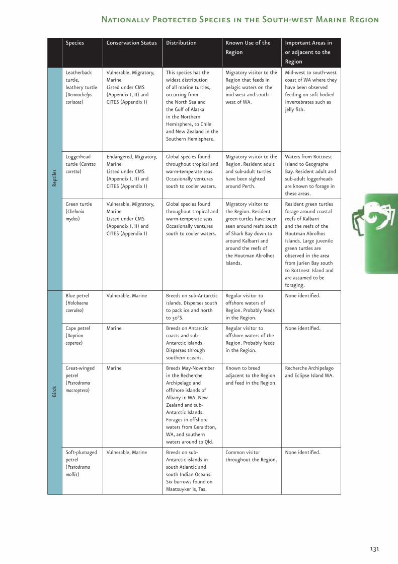
131
Nationally Protected Species in the South-west Marine Region
Species Conservation Status Distribution Known Use of the
Region
Important Areas in
or adjacent to the
RegionRe
ptile
s
Leatherback turtle, leathery turtle (Dermochelys coriacea)
Vulnerable, Migratory, MarineListed under CMS (Appendix I, II) and CITES (Appendix I)
This species has the widest distribution of all marine turtles, occurring from the North Sea and the Gulf of Alaska in the Northern Hemisphere, to Chile and New Zealand in the Southern Hemisphere.
Migratory visitor to the Region that feeds in pelagic waters on the mid-west and south-west of WA.
Mid-west to south-west coast of WA where they have been observed feeding on soft bodied invertebrates such as jelly fish.
Loggerhead turtle (Caretta caretta)
Endangered, Migratory, MarineListed under CMS (Appendix I, II) and CITES (Appendix I)
Global species found throughout tropical and warm-temperate seas. Occasionally ventures south to cooler waters.
Migratory visitor to the Region. Resident adult and sub-adult turtles have been sighted around Perth.
Waters from Rottnest Island to Geographe Bay. Resident adult and sub-adult loggerheads are known to forage in these areas.
Green turtle (Chelonia mydas)
Vulnerable, Migratory, MarineListed under CMS (Appendix I, II) and CITES (Appendix I)
Global species found throughout tropical and warm-temperate seas. Occasionally ventures south to cooler waters.
Migratory visitor to the Region. Resident green turtles have been seen around reefs south of Shark Bay down to around Kalbarri and around the reefs of the Houtman Abrolhos Islands.
Resident green turtles forage around coastal reefs of Kalbarri and the reefs of the Houtman Abrolhos Islands. Large juvenile green turtles are observed in the area from Jurien Bay south to Rottnest Island and are assumed to be foraging.
Bird
s
Blue petrel(Halobaena caerulea)
Vulnerable, Marine Breeds on sub-Antarctic islands. Disperses south to pack ice and north to 30°S.
Regular visitor to offshore waters of Region. Probably feeds in the Region.
None identified.
Cape petrel (Daption capense)
Marine Breeds on Antarctic coasts and sub-Antarctic islands. Disperses through southern oceans.
Regular visitor to offshore waters of the Region. Probably feeds in the Region.
None identified.
Great-winged petrel (Pterodroma macroptera)
Marine Breeds May-November in the Recherche Archipelago and offshore islands of Albany in WA, New Zealand and sub-Antarctic Islands. Forages in offshore waters from Geraldton, WA, and southern waters around to Qld.
Known to breed adjacent to the Region and feed in the Region.
Recherche Archipelago and Eclipse Island WA.
Soft-plumaged petrel(Pterodroma mollis)
Vulnerable, Marine Breeds on sub-Antarctic islands in south Atlantic and south Indian Oceans. Six burrows found on Maatsuyker Is, Tas.
Common visitor throughout the Region.
None identified.

132
The
Sou
th-w
est
Mar
ine
Bio
regi
on
al P
lan
: B
iore
gio
nal
Pro
file Species Conservation Status Distribution Known Use of the
Region
Important Areas in
or adjacent to the
RegionBi
rds
White-chinned petrel (Procellaria aequinoctialis)
Migratory, MarineListed under CMS (Appendix II)
Breeds in the sub-Antarctic. Occasional visitor to Australian seas.
Occasional visitor to the Region.
None identified.
Southern giant-petrel (Macronectes giganteus)
Endangered, Migratory, MarineListed under CMS (Appendix II)
Breeds on Antarctic coast, sub-Antarctic islands, including Macquarie. Disperses widely over southern oceans.
Regular visitor to oceanic waters of Region in winter. Known to feed in the Region.
None identified.
Northern giant-petrel(Macronectes halli)
Vulnerable, Migratory, MarineListed under CMS (Appendix II)
Breeds on sub-Antarctic islands, including Macquarie. Disperses in southern oceans foraging throughout the Region.
Known to forage in the Region.
None identified.
White-faced storm-petrel(Pelagodroma marina)
Marine Breeds on offshore islands of southern Australia in summer, also Kermedecs, New Zealand and sub-Antarctic islands, north and south Atlantic. Migrate in winter.
Known to breed adjacent to the Region.
Beacon Island, Morley Island, Leo Island, Stick Island at the Houtman Abrolhos Islands WA, and Lancelin Island WA.
Wilson’s storm-petrel(Oceanites oceanicus)
Migratory, MarineListed under JAMBA
Breeds on Antarctic coast and sub-Antarctic islands November -May. Disperses over all oceans, foraging pelagically.
Common visitor throughout the Region. Known to feed in the Region.
None identified.
Sooty albatross(Phoebetria fusca)
Vulnerable, Migratory, MarineListed under CMS (Appendix II)
Breeds on sub-Antarctic Islands in southern Indian and southern Atlantic Oceans.
Known to feed in the Region.
None identified.
Southern royal albatross (Diomedea epomophora)
Vulnerable, Migratory, MarineListed under CMS (Appendix II)
Breeds in New Zealand. Disperses north to 36°S.
Probably feeds in the Region.
None identified.
Northern royal albatross(Diomedea sanfordi)
Endangered, Migratory, MarineListed under CMS (Appendix II; as Diomedea epomophora)
Breeds in New Zealand, ranging over the Southern Ocean from 36°S to 52°S.
Probably feeds in the Region.
None identified.
Wandering albatross (Diomedea exulans)
Vulnerable, Migratory, MarineListed under JAMBA & CMS (Appendix II)
Breeds on sub-Antarctic islands mostly in southern Indian Ocean, including Macquarie Island, and islands off New Zealand.
Rare visitor north to Houtman Abrolhos Islands in offshore waters.
None identified.
Black-browed albatross(Thalassarche melanophris)
Vulnerable, Migratory, MarineListed under CMS (Appendix II; as Diomedea melanophris)
Breeds on sub-Antarctic Islands, including Macquarie, with widespread dispersal in pelagic zones of southern oceans, including the Region.
Very common visitor to the Region.
Waters offshore of SA.
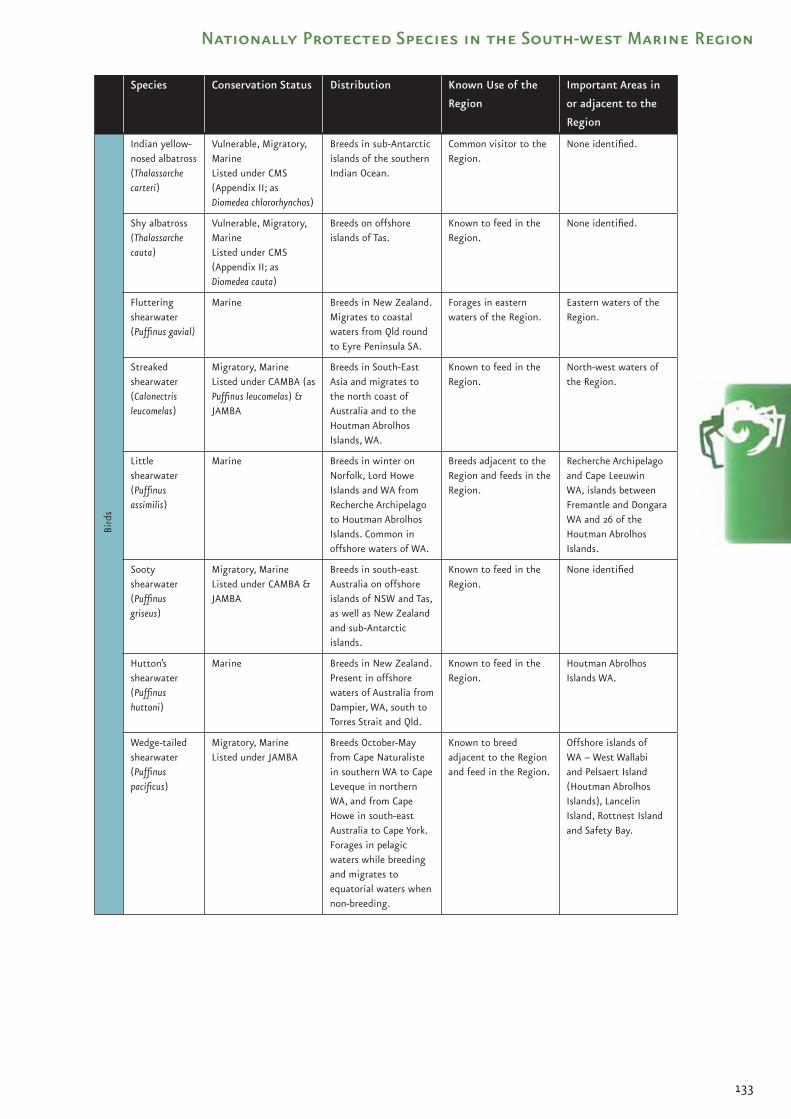
133
Nationally Protected Species in the South-west Marine Region
Species Conservation Status Distribution Known Use of the
Region
Important Areas in
or adjacent to the
RegionBi
rds
Indian yellow-nosed albatross (Thalassarche carteri)
Vulnerable, Migratory, MarineListed under CMS (Appendix II; as Diomedea chlororhynchos)
Breeds in sub-Antarctic islands of the southern Indian Ocean.
Common visitor to the Region.
None identified.
Shy albatross(Thalassarche cauta)
Vulnerable, Migratory, MarineListed under CMS (Appendix II; as Diomedea cauta)
Breeds on offshore islands of Tas.
Known to feed in the Region.
None identified.
Fluttering shearwater (Puffinus gavial)
Marine Breeds in New Zealand. Migrates to coastal waters from Qld round to Eyre Peninsula SA.
Forages in eastern waters of the Region.
Eastern waters of the Region.
Streaked shearwater (Calonectris leucomelas)
Migratory, MarineListed under CAMBA (as Puffinus leucomelas) & JAMBA
Breeds in South-East Asia and migrates to the north coast of Australia and to the Houtman Abrolhos Islands, WA.
Known to feed in the Region.
North-west waters of the Region.
Little shearwater(Puffinus assimilis)
Marine Breeds in winter on Norfolk, Lord Howe Islands and WA from Recherche Archipelago to Houtman Abrolhos Islands. Common in offshore waters of WA.
Breeds adjacent to the Region and feeds in the Region.
Recherche Archipelago and Cape Leeuwin WA, islands between Fremantle and Dongara WA and 26 of the Houtman Abrolhos Islands.
Sooty shearwater (Puffinus griseus)
Migratory, MarineListed under CAMBA & JAMBA
Breeds in south-east Australia on offshore islands of NSW and Tas, as well as New Zealand and sub-Antarctic islands.
Known to feed in the Region.
None identified
Hutton’s shearwater (Puffinus huttoni)
Marine Breeds in New Zealand. Present in offshore waters of Australia from Dampier, WA, south to Torres Strait and Qld.
Known to feed in the Region.
Houtman Abrolhos Islands WA.
Wedge-tailed shearwater(Puffinus pacificus)
Migratory, MarineListed under JAMBA
Breeds October-May from Cape Naturaliste in southern WA to Cape Leveque in northern WA, and from Cape Howe in south-east Australia to Cape York. Forages in pelagic waters while breeding and migrates to equatorial waters when non-breeding.
Known to breed adjacent to the Region and feed in the Region.
Offshore islands of WA – West Wallabi and Pelsaert Island (Houtman Abrolhos Islands), Lancelin Island, Rottnest Island and Safety Bay.

134
The
Sou
th-w
est
Mar
ine
Bio
regi
on
al P
lan
: B
iore
gio
nal
Pro
file Species Conservation Status Distribution Known Use of the
Region
Important Areas in
or adjacent to the
RegionBi
rds
Short-tailed shearwater (Puffinus tenuirostris)
Migratory, MarineListed under JAMBA
Breeds only in Australia. Breeds in the Region from Recherche Archipelago WA to Great Althorpe Island SA. Forage as far afield as the sub-Antarctic during breeding season (October- April). Migrate to the north Pacific when non-breeding.
Known to breed adjacent to the Region and feed in the Region. Forages throughout Region, as far north as Busselton WA.
Breeding colonies include: Recherche Archipelago, Great Althorpe Island, Gambier, North and Neptune Islands, Lewis, Hopkins and Williams Island near Cape Catastrophe, Greenly Island and islands in the investigator group, and Nuyts Archipelago (including Franklin, St Peter, Goat, Evans and Massilon Islands).
Flesh-footed shearwater, fleshy-footed shearwater(Puffinus cameipes)
Migratory, MarineListed under JAMBA
Breeding grounds include Recherche Archipelago WA to Cape Hamelin WA. Migrate in the winter to the Indian Ocean.
Known to breed adjacent to the Region.
Recherche Archipelago WA, and Cape Hamelin WA.
Antarctic prion (Pachyptila desolata)
Marine Breeds in Antarctica and on sub-Antarctic islands. Common winter-spring visitor to south Australian waters.
Probably feeds in the Region.
None identified.
Salvin’s prion(Pachyptila salvini)
Marine Breeds on sub-Antarctic islands. Fairly common in south WA and SA.
Known to feed in the Region.
None identified.
Fairy prion (Pachyptila turtur)
Marine Breeds on offshore islands of Tas and Vic, New Zealand and southern Indian Ocean ranging to SA and south WA.
Known to feed in the Region.
None identified.
Bridled tern(Sterna anaethetus)
Migratory, MarineListed under CAMBA & JAMBA
Breeds on islands offshore of western, northern and eastern Australia, migrating northwards to tropical seas during non-breeding (April-October). The range includes tropical and sub-tropical coasts of eastern Indian Ocean into western Pacific Ocean and north to Taiwan.
Known to breed adjacent to the Region.
Significant breeding colonies in the Region: Penguin Island, Lancelin Island, Fisherman and Beagle Islands; at the Houtman Abrolhos Islands, (Gun Island, Leo Island, Pelsaert Island, Little North Island).
Fairy tern (Sterna nereis)
Marine Breeds on offshore islands throughout Region, to north of Broome in the west, to Tas, Bass Strait and NSW in the east. Also breeds on some islands of the Great Barrier Reef.
Known to breed adjacent to the Region.
Pelsaert Island, West Wallabi Island.

135
Nationally Protected Species in the South-west Marine Region
Species Conservation Status Distribution Known Use of the
Region
Important Areas in
or adjacent to the
RegionBi
rds
Sooty tern (Sterna fuscata)
Marine Breeds on 10 islands at the Houtman Abrolhos Islands, and Lancelin Island (less than 10 pairs). In WA forages as far south as 32˚S, and may forage as far as 1500 km from breeding areas.
Known to breed adjacent to the Region and feed in the Region.
Pelsaert, Alexander, Wooded and Leo Islands, (Houtman Abrolhos Islands), Lancelin Island WA.
Gull-billed tern(Sterna nilotica)
Marine Breeds in small colonies on islands and inland lakes, mostly in southern Australia.
Scarce and patchy visitor to Region, occasional breeder in Region.
None identified.
Arctic tern (Sterna paradisaea)
Marine Breeds in the Northern Hemisphere, migrates to the Antarctic. Occurs on beaches and mudflats of southern areas of the Region.
Passes through the Region on migration.
None identified.
Caspian tern (Sterna caspia)
Migratory, MarineListed under CAMBA (as Hydroprogne caspia) & JAMBA (as Hydroprogne caspia)
Breeds (September- December in southern Australia) in small colonies and often solitarily. Forages on offshore islands throughout the Region.
Are resident in all main island groups of the Region and nest in pairs and in colonies of up to 50 nests at the Houtman Abrolhos Islands.
Breeding colonies in SA on West, Troubridge and Shoal Islands (Sir Joseph Banks Group), South Neptune, St Peter (Nuyts Archipelago) and Eyre Islands. In WA nests on many islands from Recherche Archipelago to Shark Bay. Significant islands with colonies (up to 70 pairs) include: Leo Island, West Wallabi Island and Pelsaert Island.
Lesser crested tern(Sterna bengalensis)
Migratory, MarineListed under CAMBA
Breeds on offshore islands in coastal northern Australia in spring or autumn.
Probably feeds in the Region.
None identified.
Crested tern(Sterna bergii)
Marine Breeds on offshore islands of coastal Australia, breeds September-January in southern Australia, with some autumn breeding occurring at the Houtman Abrolhos Islands (March-July).
Known to breed adjacent to the Region and feed in the Region.
Rottnest Island, Pelsaert Island, Lancelin Island. Offshore islands throughout Region.
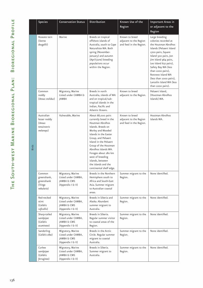
136
The
Sou
th-w
est
Mar
ine
Bio
regi
on
al P
lan
: B
iore
gio
nal
Pro
file Species Conservation Status Distribution Known Use of the
Region
Important Areas in
or adjacent to the
RegionBi
rds
Roseate tern (Sterna dougallii)
Marine Breeds on tropical offshore islands of Australia, south to Cape Naturaliste WA. Both spring (November-January) and autumn (April-June) breeding populations occur within the Region.
Known to breed adjacent to the Region and feed in the Region.
Large breeding colonies recorded at the Houtman Abrolhos Islands (Pelsaert Island 1700 pairs, Square Island 500 pairs, Jon Jim Island 964 pairs, Leo Island 627 pairs), Safety Bay WA (less than 1000 pairs), Rottnest Island WA (less than 1000 pairs), Lancelin Island WA (less than 1000 pairs).
Common noddy(Anous stolidus)
Migratory, MarineListed under CAMBA & JAMBA
Breeds in north Australia, islands of WA and on tropical/sub-tropical islands in the Indian, Pacific and Atlantic Oceans.
Known to breed adjacent to the Region.
Pelsaert Island, (Houtman Abrolhos Islands) WA.
Australian lesser noddy(Anous tenuirostris melanops)
Vulnerable, Marine About 68,000 pairs currently breed in the Houtman Abrolhos Islands. Breeds on Morley and Wooded Islands in the Easter Group, and Pelsaert Island in the Pelsaert Group of the Houtman Abrolhos Islands WA. Forages about 180 km west of breeding islands, between the islands and the continental shelf edge.
Known to breed adjacent to the Region and feed in the Region.
Houtman Abrolhos Islands WA.
Common greenshank, greenshank (Tringa nebularia)
Migratory, MarineListed under CAMBA, JAMBA & CMS (Appendix I & II)
Breeds in the Northern Hemisphere south to Africa and South-East Asia. Summer migrant to Australian coastal areas.
Summer migrant to the Region.
None identified.
Red-necked stint (Calidris ruficollis)
Migratory, MarineListed under CAMBA, JAMBA & CMS (Appendix I & II)
Breeds in Siberia and Alaska. Abundant summer migrant to Australia.
Summer migrant to the Region.
None identified.
Sharp-tailed sandpiper(Calidris acuminate)
Migratory, MarineListed under CAMBA, JAMBA & CMS (Appendix I & II)
Breeds in Siberia. Regular summer visitor to coastal areas of the Region.
Summer migrant to the Region.
None identified.
Sanderling(Calidris alba)
Migratory, MarineListed under CAMBA, JAMBA & CMS (Appendix I & II)
Breeds in the Arctic Circle. Regular summer migrant to coastal Australia.
Summer migrant to the Region.
None identified.
Curlew sandpiper (Calidris ferruginea)
Migratory, MarineListed under CAMBA, JAMBA & CMS (Appendix I & II)
Breeds in Siberia. Summer migrant to Australia.
Summer migrant to the Region.
None identified.

137
Nationally Protected Species in the South-west Marine Region
Species Conservation Status Distribution Known Use of the
Region
Important Areas in
or adjacent to the
RegionBi
rds
Red knot, knot(Calidris canutus)
Migratory, MarineListed under CAMBA, JAMBA & CMS (Appendix I & II)
Breeds in the Arctic Circle. Regular summer migrant to Australia.
Summer migrant to the Region.
None identified.
Grey plover (Pluvialis squatarola)
Migratory, MarineListed under CAMBA, JAMBA & CMS (Appendix I & II)
Breeds in the Arctic Circle. Regular summer migrant to Australia.
Summer migrant to the Region.
None identified.
Ruddy turnstone(Arenaria interpres)
Migratory, MarineListed under CAMBA, JAMBA & CMS (Appendix I & II)
Breeds in the Arctic Circle. Regular summer migrant to Australia.
Summer migrant to the Region.
None identified.
Pacific golden plover (Pluvialis fulva)
Migratory, MarineListed under CAMBA, JAMBA & CMS (Appendix I & II)
Breeds in the Arctic Circle. Regular summer migrant to Australia..
Summer migrant to the Region.
None identified.
Common sandpiper (Actitis hypoleucos)
Migratory, MarineListed under CAMBA (as Tringa hypoleucos), JAMBA (as Tringa hypoleucos) & CMS (Appendix I & II)
Breeds in the Northern Hemisphere. Regular summer migrant to the Region.
Summer migrant to the Region.
None identified.
Kelp gull (Larus dominicanus)
Marine Breeds patchily in coastal south and south-east islands of Australia. Also breeds in New Zealand and sub-Antarctic.
Known to breed adjacent to the Region.
Breeds at Bremer Bay.
Silver gull (Larus novaehollandiae)
Marine Breeds on mainland and on offshore islands throughout Australia from August-December (southern Australia).
Known to breed adjacent to the Region.
Penguin Island, Carnac Island, Houtman Abrolhos Islands.
Pacific gull(Larus pacificus)
Marine Breeds on offshore islands in pairs and small, loose colonies throughout the South-west Marine Region, (August-December). Moves to coastal regions during winter to feed.
Known to breed adjacent to the Region.
Pelsaert Island (Houtman Abrolhos Islands).
Arctic jaeger (Stercocarius parasiticus)
Migratory, MarineListed under JAMBA
Breeds throughout Arctic, dispersing to Australian waters October-April.
Summer migrant to the Region.
None identified.
Little penguin(Eudyptula minor)
Marine Known to breed on Carnac Island WA through SA, Vic and Tas, north to NSW, and in New Zealand.
Known to breed adjacent to the Region and feed in the Region.
Offshore islands within the Region.
Red-tailed tropicbird (Phaethon rubricauda)
Marine Breeds on offshore islands and some coastal areas of Australia.
Known to breed adjacent to the Region.
Sugarloaf Rock and Pelsaert Island (Houman Abrolhos Islands) WA.

138
The
Sou
th-w
est
Mar
ine
Bio
regi
on
al P
lan
: B
iore
gio
nal
Pro
file Species Conservation Status Distribution Known Use of the
Region
Important Areas in
or adjacent to the
RegionBi
rds
Pelican (Pelecanus conspicillatus)
Marine Breeds throughout mainland Australia in all seasons.
May breed adjacent to the Region.
None identified.
Australasian gannet(Morus serrator)
Marine Breeds Tas, Vic. and New Zealand, but regular visitor to Region.
Common visitor throughout offshore waters of the Region.
None identified.
Osprey (Pandion haliaetus)
Migratory, MarineListed under CITES (Appendix II) & CMS (Appendix II)
Breeds on coasts and islands of Australia.
Known to breed adjacent to the Region.
Pelsaert Island (Houtman Abrolhos Islands) WA, Eyre Peninsula SA, Kangaroo Island SA.
White-bellied sea-eagle (Haliaeetus leucogaster)
Migratory, MarineListed under CAMBA & CMS (Appendix II)
Breeds in coastal areas throughout Australia.
Known to breed adjacent to the Region.
West Wallabi Island, Houtman Abrolhos Islands WA, Recherche Archipelago WA, Eyre Peninsula SA, Yorke Peninsula SA.
Cape Barren goose (south-western), Recherche Cape Barren Goose (Cereopsis novaehollandiae grisea)
Vulnerable, Marine Breeds in the Recherche Archipelago, dispersing west and north to the mainland (Cape Arid and Esperance).
Known to breed adjacent to the Region.
Recherche Archipelago WA.
Black-faced cormorant (Phalacrocorax fuscescens)
Marine Breeds on islands of southern Australia.
Known to breed adjacent to the Region.
None identified.
Rainbow bee-eater(Merops ornatus)
Migratory, MarineListed under JAMBA
Summer breeding migrant in Region except on Rottnest Island, WA where it is a summer breeder.
Known to breed adjacent to the Region.
Rottnest Island WA.
Fork-tailed swift (Apus pacificus)
Migratory, MarineListed under CAMBA & JAMBA
Breeds in northern Asia, and is a regular summer migrant to the Region.
Summer migrant to the Region
Usually observed around islands.
Seal
s, F
ur S
eals
& S
ea L
ions
Australian sea lion(Neophoca cinerea)
Vulnerable, Marine Known range of species falls throughout the Region.
Known to breed and feed adjacent to the Region throughout the year.
Colonies occur from Houtman Abrolhos Islands WA to the Pages Islands in SA, including 28 breeding colonies in WA and 38 in SA.
New Zealand fur seal(Arctocephalus forsteri)
MarineListed under CITES (Appendix II)
Ranges from the south coast of WA to New Zealand. Part of the known range of the species extends into the Region.
Known to breed adjacent to the Region and feed in the Region.
Colonies occur on the south coast of WA and SA, including 17 breeding colonies in WA and 13 in SA (two in Tas.).

139
Nationally Protected Species in the South-west Marine Region
Species Conservation Status Distribution Known Use of the
Region
Important Areas in
or adjacent to the
RegionSe
als,
Fur
Sea
ls &
Sea
Lio
ns
Australian fur seal(Arctocephalus pusillus)
Marine Listed under CITES (Appendix II)
Ranges from eastern SA to southern NSW and Tas. Part of the known range of the species extends into the Region.
Known to feed in the Region.
Important feeding areas in the eastern part of the Region. Large numbers haul-out adjacent to the Region on Kangaroo Island (Cape Gantheaume and Cape du Couedic), and are occasionally seen at the Neptune Islands.
Wha
les,
Dol
phin
s &
Por
pois
es
Sei whale (Balaenoptera borealis)
Vulnerable, Migratory, Cetacean Listed under CITES (Appendix I) and CMS (Appendix I & II)
Global species found in all sub-polar, temperate and sub-tropical waters. The Region falls within the known range of the species.
Known to feed in the Region.
Possible feeding areas in the Perth Canyon and waters to the south of Kangaroo Island.
Blue whale(Balaenoptera musculus)
Endangered, Migratory, CetaceanListed under CITES (Appendix I) and CMS (Appendix I)
Global species. Region falls within the known range of the species.
Known to feed in the Region.
Feeding areas in the Duntroon Basin, Perth Canyon and waters to the south of Kangaroo Island. Possible resting area in Geographe Bay.
Fin whale(Balaenoptera physalus)
Vulnerable, Migratory, CetaceanListed under CITES (Appendix I) and CMS (Appendix I & II)
Global species found in polar and temperate waters. Region falls within the known range of the species.
Known to feed in the Region.
Feeding areas in the Perth Canyon and waters to the south of Kangaroo Island.
Bryde’s whale (Balaenoptera edeni)
Migratory, CetaceanListed under CITES (Appendix I) and CMS (Appendix II)
Found in tropical and temperate waters between 40ºN and 40ºS. Part of the known range extends into the Region possibly in association with the Leeuwin Current.
Data deficient. None identified. Records from the Houtman Abrolhos Islands.
Minke whale, dwarf minke whale (Balaenoptera acutorostrata)
CetaceanListed under CITES (Appendix I)
Found in tropical and warm temperate waters of the Southern Hemisphere. Part of the known range extends into the Region.
Data deficient. Possibly migrates through the Region.
None identified.
Humpback whale (Megaptera novaeangliae)
Vulnerable, Migratory, CetaceanListed under CITES (Appendix I) and CMS (Appendix I)
Found in several parts of the Northern and Southern Hemispheres. Migrate from polar summer breeding grounds to subtropical winter breeding grounds. Part of the migration route falls within the Region.
Migrate through Region. Important resting areas.
Resting areas in Geographe Bay, Cape Leeuwin/Flinders Bay and the Houtman Abrolhos Islands.

140
The
Sou
th-w
est
Mar
ine
Bio
regi
on
al P
lan
: B
iore
gio
nal
Pro
file Species Conservation Status Distribution Known Use of the
Region
Important Areas in
or adjacent to the
RegionW
hale
s, D
olph
ins
& P
orpo
ises
Southern right whale (Eubalaena australis)
Endangered, Migratory, CetaceanListed under CITES (Appendix I) and CMS (Appendix I)
Found in sub-Antarctic, temperate and sub-tropical waters. Region falls within the known range of the species.
Known to breed in the Region.
The main calving areas currently known for southern right whales within and adjacent to the Region include: Doubtful Islands Bay (including Point Ann/Point Charles area), Israelite Bay area, Twilight Cove, Flinders Bay, Albany/Cape Riche area, and Yokinup Bay/Cape Arid area, Head of Bight, Fowlers Bay, and Encounter Bay.
Pygmy right whale(Caperea marginate)
Migratory, CetaceanListed under CITES (Appendix I) and CMS (Appendix II)
Found in temperate and sub-Antarctic waters. Region falls within the known range of the species.
Data deficient. Possibly feeds in the Region.
Possibly feed in areas of upwelling around Kangaroo Island, southern Eyre Peninsula and possibly south-western WA.
Sperm whale(Physeter macrocephalus)
Migratory, CetaceanListed under CITES (Appendix I as Physeter catodon) and CMS (Appendix I & II)
Global species found in deep tropical and temperate waters. Males also found in polar regions. Region falls within the known range of the species.
Feeding aggregations occur in the Region.
Concentrations in areas of upwellings close to the edge of the continental shelf at Albany, south-west of Kangaroo Island and between Cape Leeuwin and Esperance. Possible feeding area in Perth Canyon.
Pygmy sperm whale(Kogia breviceps)
CetaceanListed under CITES (Appendix II )
Oceanic distribution in all tropical and temperate waters of the world. Mostly beyond the edge of the continental shelf. Region falls within known range of the species.
Data deficient. Possibly feeds in the Region.
None identified.
Dwarf sperm whale(Kogia simus)
CetaceanListed under CITES (Appendix II)
Found over the continental shelf and slope off all tropical and temperate coasts.
Data deficient. None identified.
True’s beaked whale(Mesoplodon mirus)
CetaceanListed under CITES (Appendix II)
Thought to occur in deep temperate oceans. Region falls within the presumed range of the species.
Data deficient. May be associated with colder shelf edge waters and canyon habitats
Andrew’s beaked whale(Mesoplodon bowdoini)
CetaceanListed under CITES (Appendix II)
Circumpolar distribution north of the Antarctic convergence between 32ºS and 54º30’S. Part of known range extends into Region.
Data deficient. Primarily off the shelf.

141
Nationally Protected Species in the South-west Marine Region
Species Conservation Status Distribution Known Use of the
Region
Important Areas in
or adjacent to the
RegionW
hale
s, D
olph
ins
& P
orpo
ises
Gray’s beaked whale, scamperdown whale (Mesoplodon grayi)
CetaceanListed under CITES (Appendix II)
Circumglobal in temperate waters of the Southern Hemisphere. Region falls within the known range of the species.
Data deficient. May be associated with colder shelf edge waters and canyon habitats. Possible feeding area in Geographe Bay.
Hector’s beaked whale(Mesoplodon hectori)
CetaceanListed under CITES (Appendix II)
Circumglobal in the Southern Hemisphere between 35ºS and 55ºS. Part of presumed range extends into Region.
Data deficient. May be associated with colder shelf edge waters and canyon habitats.
Strap-toothed beaked whale, strap-toothed whale, Layard’s beaked whale (Mesoplodon layardii)
CetaceanListed under CITES (Appendix II)
Widespread and common in the Southern Ocean and adjoining waters, occurring between approximately 30ºS and the Antarctic Convergence. Region falls within the known range of the species. Seasonally common in the Region between January and April.
Possibly feeds and breeds in or adjacent to the Region.
May be associated with colder shelf edge waters and canyon habitats.
Shepherd’s beaked whale, Tasman beaked whale(Tasmacetus shepherdi)
CetaceanListed under CITES (Appendix II)
Circumpolar in mid-latitudes of the Southern Hemisphere from 33ºS to 50ºS. Part of the range extends into Region.
Data deficient. Primarily off the shelf. May be associated with canyon habitats.
Arnoux’s beaked whale(Berardius arnuxii)
CetaceanListed under CITES (Appendix I)
Circumglobal in temperate and Antarctic waters of the Southern Ocean. The Region falls within the known range of the species.
Data deficient. Primarily off the shelf.
Cuvier’s beaked whale, goose-beaked whale (Ziphius cavirostris)
CetaceanListed under CITES (Appendix II)
Oceanic species. Worldwide distribution in all temperate and tropical waters between 60ºN and 55ºS. Region falls within known range of the species.
Data deficient. Primarily off the shelf. May be associated with canyon habitats.
Southern bottlenose whale (Hyperoodon planifrons)
CetaceanListed under CITES (Appendix I)
Circumglobal distribution in the mid to high latitudes of the Southern Hemisphere. Region falls within the known range of the species.
Data deficient. None identified.
Killer whale, orca (Orcinus orca)
Migratory, CetaceanListed under CITES (Appendix II) and CMS (Appendix II)
Global species found in all oceans and seas ranging from polar to tropical. Region falls within the known range of the species.
Known to feed in the Region.
No specific areas. Often observed near pinniped colonies on the west coast, in the Great Australian Bight and around Kangaroo Island and the Eyre Peninsula.

142
The
Sou
th-w
est
Mar
ine
Bio
regi
on
al P
lan
: B
iore
gio
nal
Pro
file Species Conservation Status Distribution Known Use of the
Region
Important Areas in
or adjacent to the
RegionW
hale
s, D
olph
ins
& P
orpo
ises
False killer whale(Pseudorca crassidens)
CetaceanListed under CITES (Appendix II)
Global species found in deep temperate and tropical waters. Region falls within the known range of the species.
Possibly resident in the Region throughout the year.
None identified.
Long-finned pilot whale (Globicephala melas)
CetaceanListed under CITES (Appendix II)
Circumglobal in the Southern Hemisphere. Region falls within the known range of the species.
Possible resident in the Region throughout the year.
None identified.
Short-finned pilot whale (Globicephala macrorhynchus)
CetaceanListed under CITES (Appendix II)
Found in tropical and warm-temperate waters world-wide, between about 41ºS and 45ºN. Part of range extends into Region.
Data deficient. None identified.
Common dolphin(Delphinus delphis)
CetaceanListed under CITES (Appendix II)
Found in tropical, subtropical and temperate waters of the Atlantic, Pacific and Indian Oceans, in both shallow and deep offshore waters. Region falls within the known range of the species.
Resident throughout the year.
No specific areas but common in SA and south south-western WA.
Risso’s dolphin, grampus (Grampus griseus)
CetaceanListed under CITES (Appendix II)
Inhabits tropical, sub-tropical, temperate and sub-Antarctic waters between 60ºN and 60ºS. Region falls within known range of the species.
Data deficient. None identified.
Striped dolphin, euphrosyne dolphin(Stenella coeruleoalba)
CetaceanListed under CITES (Appendix II)
Found in deep temperate and tropical waters. Part of the range extends into the Region.
Data deficient. None identified.
Spotted dolphin, pantropical spotted dolphin (Stenella attenuate)
CetaceanListed under CITES (Appendix II)
Found in tropical and warm temperate oceanic zones between 40ºN and 40ºS. Both inshore and oceanic. Region falls within known range of the species.
Data deficient. Possibly feeds in the Region.
None identified.
Long-snouted spinner dolphin (Stenella longirostris)
CetaceanListed under CITES (Appendix II)
Found in tropical, subtropical and occasionally temperate waters. Part of known range extends into the Region (associated with Leeuwin Current).
Data deficient. None identified.

143
Nationally Protected Species in the South-west Marine Region
Species Conservation Status Distribution Known Use of the
Region
Important Areas in
or adjacent to the
RegionW
hale
s, D
olph
ins
& P
orpo
ises
Bottlenose dolphin (Tursiops truncates)
CetaceanListed under CITES (Appendix II)
Found in all temperate and tropical waters of the world. Usually in latitudes lower than 45º. Region falls within known range of the species.
Resident throughout the year.
None identified.
Southern right whale dolphin (Lissodelphis peronii)
CetaceanListed under CITES (Appendix II)
Circumglobal in the Southern Hemisphere. Region falls within the known range of the species.
Data deficient. None identified.
Table C2 Protected species that may infrequently occur in the South-west Marine Region
Species Conservation Status
Bony
fish
Blue-finned ghost pipefish, robust ghost pipefish(Solenostomus cyanopterus)
Marine
Robust spiny pipehorse, robust pipehorse(Solegnathus robustus)
Marine
Shaggy pipefish, prickly pipefish(Hypselognathus horridus)
Marine
Leafy sea-dragon(Phycodurus eques)
Marine
Weedy sea-dragon, common sea-dragon(Phyllopteryx taeniolatus)
Marine
Gale’s pipefish(Campichthys galei)
Marine
Brock’s pipefish(Halicampus brocki)
Marine
Bentstick pipefish, bendstick pipefish, short-tailed pipefish, double-ended pipefish(Trachyrhamphus bioarctatus)
Marine
Port Phillip pipefish(Vanacampus phillipi)
Marine
Wide-body pipefish(Stigmatopora nigra)
Marine
Bony-headed pipefish(Nannocampus subosseus)
Marine
West Australian seahorse(Hippocampus subelongatus)
MarineListed under CITES (Appendix II)
Western spiny seahorse, narrow-bellied seahorse(Hippocampus angustus)
Marine Listed under CITES (Appendix II)
Short-headed seahorse, short-snouted seahorse(Hippocampus breviceps)
MarineListed under CITES (Appendix II)
Southern potbelly seahorse, potbelly seahorse, pot-bellied seahorse(Hippocampus abdominalis, Hippocampus bleekeri)
Marine Listed under CITES (Appendix II)

144
The
Sou
th-w
est
Mar
ine
Bio
regi
on
al P
lan
: B
iore
gio
nal
Pro
file Species Conservation Status
Rept
iles
Elegant sea-snake, bar-bellied sea-snake(Hydrophis elegans)
Marine
Ocellated (or spotted) sea-snake(Hydrophis ocellatus)
Marine
Olive-headed sea-snake(Disteira major)
Marine
Shark Bay sea-snake(Aipysurus pooleorum)
Marine
Flatback turtle (Natator depressus) Vulnerable, Migratory and Marine Listed under CMS (Appendix I, II) and CITES (Appendix I)
Hawksbill turtle (Eretmochelys imbricata) Vulnerable, Migratory and MarineListed under CMS (Appendix I, II) and CITES (Appendix I)
Olive ridley turtle (Lepidochelys olivacea) Vulnerable, Migratory and MarineListed under CMS (Appendix I, II) and CITES (Appendix I)
Bird
s
Gould’s petrel(Pterodroma leucoptera)
Marine (subspecies P. l. leucoptera listed as Endangered & Migratory. Listed under JAMBA)
Grey petrel(Procellaria cinerea)
Migratory, MarineListed under CMS (Appendix II)
Kerguelen petrel(Lugensa brevirostris)
Marine
Black-bellied storm-petrel(Fregetta tropica)
Marine
Grey-backed storm-petrel(Garrodia nereis)
Marine
Leach’s storm-petrel(Oceanodroma leucorhoa)
Migratory, MarineListed under CAMBA & JAMBA
Light-mantled sooty albatross(Phoebetria palpebrata)
Migratory, MarineListed under CMS (Appendix II)
Amsterdam albatross(Diomedea amsterdamensis)
Endangered, Migratory, MarineListed under CMS (Appendix I)
Gibson’s albatross(Diomedea gibsoni)
Vulnerable, Migratory, MarineListed under CMS (Appendix II; as Diomedea exulans)
Tristan albatross(Diomedea dabbenena)
Endangered, Migratory, MarineListed under CMS (Appendix II; as Diomedea exulans)
Buller’s albatross(Thalassarche bulleri)
Vulnerable, Migratory, MarineListed under CMS (Appendix II; as Diomedea bulleri)
Campbell albatross(Thalassarche impavida)
Vulnerable, Migratory, MarineListed under CMS (Appendix II; as Diomedea melanophris)
Grey-headed albatross(Thalassarche chrysostoma)
Vulnerable, Migratory, MarineListed under CMS (Appendix II; as Diomedea chrysostoma)
Salvin’s albatross(Thalassarche salvini)
Vulnerable, Migratory, MarineListed under CMS (Appendix II; as Diomedea cauta)

145
Nationally Protected Species in the South-west Marine Region
Species Conservation Status
Bird
sYellow-nosed albatross, Atlantic yellow-nosed albatross(Thalassarche chlororhynchos)
Migratory, MarineListed under CMS (Appendix II; as Diomedea chlororhynchos)
Common diving-petrel(Pelecanoides urinatrix)
Marine
Broad-billed prion(Pachyptila vittate)
Marine
Slender-billed prion(Pachyptila belcheri)
Marine
Southern fulmar(Fulmarus glacialoides)
Marine
White tern(Gygis alba)
Marine
White-winged black tern(Chlidonias leucoptera)
Migratory, MarineListed under CAMBA & JAMBA
Whiskered tern(Chlidonias hybrida)
Marine
Antarctic tern(Sterna vittata)
Marine
Common tern(Sterna hirundo)
Migratory, MarineListed under CAMBA & JAMBA
Little tern(Sterna albifrons)
Migratory, MarineListed under CAMBA, JAMBA & CMS (Appendix II)
Marsh sandpiper, little greenshank(Tringa stagnatilis)
Migratory, MarineListed under CAMBA, JAMBA & CMS (Appendix I & II)
Latham’s snipe, Japanese snipe(Gallinago hardwickii)
Migratory, MarineListed under CAMBA, JAMBA & CMS (Appendix I & II)
Australian painted snipe(Rostratula australis)
Vulnerable, Migratory, MarineListed under CAMBA (as Rostratula benghalensi s. lat.)
Oriental plover, oriental dotterel(Charadrius veredus)
Migratory, MarineListed under JAMBA & CMS (Appendix I & II)
Hooded plover (eastern subspecies)(Thinornis rubricollis rubricollis)
Marine
Great skua(Catharacta skua)
Marine
South polar skua(Catharacta maccormicki)
Migratory, MarineListed under JAMBA (as Stercorarius maccormicki)
Great egret, white egret(Ardea alba)
Migratory, MarineListed under CAMBA (as Egretta alba), JAMBA (as Egretta alba) & CITES (Appendix III; as Casmerodius albus)
Cattle egret(Ardea ibis)
Migratory, MarineListed under CAMBA (as Ardeola ibis), JAMBA (as Ardeola ibis) & CITES (Appendix III; as Bubulcus ibis)
King penguin(Aptenodytes patagonicus)
Marine

146
The
Sou
th-w
est
Mar
ine
Bio
regi
on
al P
lan
: B
iore
gio
nal
Pro
file Species Conservation Status
Bird
sErect-crested penguin(Eudyptes sclateri)
Marine
Fiordland penguin(Eudyptes pachyrhynchus)
Marine
Rockhopper penguin(Eudyptes chrysocome)
Marine
Cape gannet(Morus capensis)
Marine
Lesser frigatebird(Fregata ariel)
Migratory, MarineListed under CAMBA & JAMBA
White-throated needletail(Hirundapus caudacutus)
Migratory, MarineListed under CAMBA & JAMBA
Orange-bellied parrot(Neophema chrysogaster)
Endangered, Migratory, MarineListed under JAMBA & CITES (Appendix I)
Seal
s &
Fur
Sea
ls
Southern elephant seal (Mirounga leonine)
Vulnerable, MarineListed under CITES (Appendix II)
Leopard seal (Hydrurga leptonyx)
Marine
Crabeater seal (Lobodon carcinophagus)
Marine
Weddell seal (Leptonochotes weddellii)
Marine
Antarctic fur seal (Arctocephalus gazella)
MarineListed under CITES (Appendix II)
Sub-Antarctic fur seal (Arctocephalus tropicalis)
Vulnerable, MarineListed under CITES (Appendix II)
Dug
ong Dugong
(Dugong dugon)Migratory, Marine Listed under CITES (Appendix I) and CMS (Appendix II)
Wha
les,
Dol
phin
s &
Por
pois
es
Antarctic minke whale, dark-shoulder minke whale (Balaenoptera bonaerensis)
Migratory, CetaceanListed under CITES (Appendix I) & CMS (Appendix II)
Blainville’s beaked whale, dense-beaked whale (Mesoplodon densirostris)
CetaceanListed under CITES (Appendix II)
Ginkgo-toothed beaked whale (Mesoplodon ginkgodens)
CetaceanListed under CITES (Appendix II)
Melon-headed whale(Peponocephala electra)
CetaceanListed under CITES (Appendix II)
Pygmy killer whale(Feresa attenuate)
CetaceanListed under CITES (Appendix II)
Spotted bottlenose dolphin, Indo-Pacific bottlenose dolphin (Tursiops aduncus)
CetaceanListed under CITES (Appendix II)
Dusky dolphin (Lagenorhynchus obscurus)
Migratory, CetaceanListed under CITES (Appendix II ) and CMS (Appendix II)
Rough-toothed dolphin(Steno bredanensis)
CetaceanListed under CITES (Appendix II)
Fraser’s dolphin, Sarawak dolphin (Lagenodelphis hosei)
CetaceanListed under CITES (Appendix II)

147
Nationally Protected Species in the South-west Marine Region

148Grey nurse sharks. Photo: David Harasti.

149
Protected Species Group Report Cards
Appendix D South-west Marine Region Protected Species Group Report Cards
These report cards summarise information on those
species that occur in the South-west Marine Region
and are protected under the Environment Protection and
Biodiversity Conservation Act 1999 (EPBC Act). The report
cards present relevant information on species groups and
are designed to be updated as new information becomes
available. The report cards included in this appendix are
current at April 2007. Updates of the report cards will
be available on the web at <www.environment.gov.au/
coasts/mbp/south-west>.
Protected species occurring in the South-west Marine
Region for which species group report cards have been
compiled include:
D1 Sharks
D2 Bony fish (including seahorses, sea-dragons,
pipefish, ghost pipefish and orange roughy)
D3 Reptiles (marine turtles and sea snakes)
D4 Seabirds
D5 Pinnipeds (fur seals, seals and sea lions)
D6 Cetaceans (whales, dolphins and porpoises)
D1 South-west Marine Region Protected Species Group Report Card – Sharks
Current at May 2007. For updates see
<www.environment.gov.au/coasts/mbp/south-west>
General information
Sharks, rays, skates and chimaeras (or ghost sharks) are
cartilaginous fish belonging to the class Chondrichthyes.
Of the 297 species that occur in Australian waters, it
is estimated that 152 occur in the South-west Marine
Region. The South-west Marine Region: Ecosystems and Key
Species Groups report provides an overview of this species
group in the South-west Marine Region.
Nationally protected species
Three species of sharks found in the Region are listed
under the EPBC Act (Table D1). White and whale sharks
are also listed under international instruments. Recovery
Plans are in force for each of these three species and can
be found at <www.environment.gov.au/coasts/species/
sharks>.
Table D1 Sharks listed as threatened or migratory under the EPBC Act that are known to occur in the South-west Marine
Region
Species Conservation Status Australian Government Conservation Plans or
Strategies for the Species
White shark(Carcharodon carcharias)
Vulnerable, MigratoryListed under CITES (Appendix II) and CMS (Appendix I)
White Shark (Carcharodon carcharias) Recovery Plan (July 2002)
Recovery Plan for the Grey Nurse Shark (Carcharias taurus) in Australia (June 2002)
National Plan of Action for the Conservation and Management of Sharks (2004)
Whale Shark (Rhincodon typus) Recovery Plan 2005-2010 (2005)
•
•
•
•
Grey nurse shark (Carcharias taurus) – west coast population
Vulnerable
Whale shark(Rhincodon typus)
Vulnerable, MigratoryListed under CITES (Appendix II) and CMS (Appendix II)

150
The
Sou
th-w
est
Mar
ine
Bio
regi
on
al P
lan
: B
iore
gio
nal
Pro
file
Ecology of protected sharks in the
South-west Marine Region
White shark
The white shark is widely distributed throughout
temperate and sub-tropical regions, and is most
frequently observed and captured in inshore cool to
warm temperate continental waters. Available data from
recent tracking studies show that white sharks can
travel thousands of kilometres. Their movements appear
to have seasonal patterns, with individual sharks moving
up the west coast as far as North West Cape in Western
Australia during spring, and returning south during the
summer.
White sharks eat a variety of prey including finfish,
other sharks and rays, marine mammals such as seals, sea
lions, dolphins and whales, as well as squid, crustaceans
and seabirds. Their diet is known to change with size –
juveniles less than 2.7 m feed primarily on fish and other
sharks and rays, while larger sharks (reaching up to
6 m in length), are known to feed on marine mammals.
Although catch estimates for white sharks are based
on incomplete information, the South-west Marine
Region appears to be an important area for the species
as available records of incidental catches in fisheries are
highest in the Region and are not well correlated with
fishing effort (Malcolm et al. 2001). White sharks thus
appear to be more abundant in the South-west Marine
Region, particularly in the waters from Shark Bay to
Bunbury and in waters of the Great Australian Bight,
than in other parts of Australian waters (Malcolm et al.
2001). Due to the internationally threatened status of
this species, the Region may not only be significant for
the conservation and management of white sharks in
Australia, but possibly also in a global context.
Grey nurse shark
The grey nurse shark is listed as two separate populations
under the EPBC Act. The west coast population is listed
as vulnerable, while the east coast population is listed as
critically endangered. The species is thought to occur in
all waters off the Australian mainland but is considered
rare in the Northern Territory and through the southern
extent of its range, thus it is thought that the west
and east coast populations are separate. The extent to
which the west coast population of the grey nurse shark
extends into South Australian waters has not been well
established to date.
The species is found primarily in warm-temperate (from
sub-tropical to cool-temperate) inshore waters around
rocky reefs and islands, and is occasionally found in the
surf zone and in shallow bays. Grey nurse sharks have
been recorded at varying depths. They are commonly
found between 15 m and 40 m, but have occasionally
been recorded at depths of around 200 m. The diet of
grey nurse sharks in Australia has not been well studied,
but it is likely to consist of species such as pilchards,
jewfish, tailor, bonito, moray eels, wrasses, sea mullet,
flatheads, yellowtail kingfish, small sharks, squid and
crustaceans.
While grey nurse sharks are known to aggregate at sites
on the east coast of Australia, aggregation sites for this
species in Western Australia are less well understood.
To date, no aggregation areas have been identified
in Western Australia, but this could be because of the
limited number of studies on grey nurse shark habitat in
this State. A recent tracking study showed that juveniles
can move hundreds of kilometres north along the
Western Australia coast, from Perth to Kalbarri, before
returning south (McAuley 2004). The length of the
White shark. Photo: Rachel Robbins, Fox Shark Research Station.

151
Protected Species Group Report Cards
migration indicates that grey nurse sharks do not need
to stay close to what is considered their ‘typical’ habitat,
such as rocky ledges, gutters and caves (McAuley 2004).
The study also suggests that grey nurse sharks in
Western Australia spend most of their time at depths
between 20 m and 60 m but can spend periods of up
to two weeks at depths greater than 110 m (McAuley
2004).
Whale shark
Whale sharks are a wide-ranging species with a broad
distribution. They are usually observed between latitudes
30°N and 35°S in tropical and warm temperate seas, both
oceanic and coastal. The species is generally encountered
close to, or at the surface, as single individuals or
occasionally in schools or aggregations of up to
hundreds of sharks. Although it has been suggested that
this species prefers waters with temperatures between
21-25°C, the whale sharks sighted at Ningaloo Marine
Park (which is located to the north of the Region) are
predominantly found in waters with temperatures
averaging 27°C.
No whale shark aggregation areas have been
identified in the Region and no interactions with
the species, such as capture in fisheries, are known
to occur in the Region, so the species will not be
considered further here. Further information on
whale sharks and threats to the species is available at
<www.environment.gov.au/biodiversity/threatened/
publications/recovery/r-typus>.
Important areas for sharks in the South-
west Marine Region
Important areas in the South-west Marine Region are
identified for species listed as threatened or migratory
under the EPBC Act as they are matters of national
environmental significance (see Chapter 3.2 for more
information on matters of national environmental
significance and requirements under the EPBC Act).
Important nursery and feeding areas in the Region have
been identified for white sharks. These areas are located
in both waters of the South-west Marine Region and
in coastal waters under the jurisdiction of the South
Australian and Western Australian Governments.
The following areas are known to be particularly
important for white sharks:
The inshore waters of the Great Australian Bight – Small
juvenile white sharks (under 2 m) are commonly
encountered in this area. It is presumed that the
apparent abundance of small white sharks in this area is
due to pupping in this area or nearby.
Head of Bight – Movements of white sharks are known to
increase seasonally at the Head of the Great Australian
Bight and may be linked to the seasonal availability and
movements of prey including snapper, gummy sharks
and Australian salmon, and to the calving of southern
right whales.
Pinniped (seals and sea lion) colonies – Evidence suggests
that these are areas where white sharks can aggregate
or frequently revisit to feed and are most likely areas of
habitat critical to the survival of the species (Bruce et al.
2005). For instance, white sharks are regularly observed
around the Neptune Islands and Dangerous Reef, which
have large breeding colonies of New Zealand fur seals
and Australian sea lions respectively. See Figure D1.1 for
locations of pinniped colonies in the Region.
Spencer Gulf and Gulf St Vincent – These areas are
considered important feeding grounds for sub-adult
white sharks, although juvenile and large adult
sharks have also been observed in these areas. White
sharks presumably target dolphins, finfish and other
elasmobranchs abundant in these gulfs.
Grey nurse shark. Photo: David Harasti.

152
The
Sou
th-w
est
Mar
ine
Bio
regi
on
al P
lan
: B
iore
gio
nal
Pro
file Figure D1.1 Pinniped colonies identified as important feeding grounds for white sharks
Known interactions, threats and
mitigation measures
Fisheries
Sharks are particularly susceptible to fishing pressure
because of their specialised life history strategies. They
generally show slow growth, late attainment of sexual
maturity, low fecundity and a close stock-recruitment
relationship. White sharks are considered to be naturally
low in abundance, producing relatively few young.
Similarly the grey nurse shark matures slowly and is
thought to only reproduce every second year, producing
a maximum of two pups each litter.
In addition, the demand and prices for shark products,
including fins, is relatively high, which adds to the
susceptibility of some shark species to fishing pressure.
Commercial fisheries
White sharks and grey nurse sharks are known to
interact with commercial fishing operations in the
Region. Although these species are not targeted, they
are inadvertently caught as by-catch.
It is considered that the incidental capture of white
sharks on longlines and in nets poses the greatest threat
to the species. White sharks have been reported as by-
catch in a number of fisheries including the Southern
and Eastern Scalefish and Shark Fishery, Western
Australian Temperate Shark Fisheries, various demersal
longline fisheries and in tuna ‘grow out’ cages in South
Australia. They are also occasionally caught in crab trap
and rock lobster pot ropes and in demersal trawls.
Catches of white sharks are not evenly distributed
across southern Australia and are not well correlated
with effort, nor are there many independent observer
programmes in the Region to verify interaction rates
with threatened species. However, available information
suggests that there are more interactions between
white sharks and fishing activities along the west coast
of Western Australia, from Shark Bay to Bunbury, and in
the Great Australian Bight than other areas of Australia
(Malcolm et al. 2001). Most white sharks reported as
caught in fishing operations are either juveniles or sub-
adults (Malcolm et al. 2001).
The actual rate of capture of white sharks by commercial
fishers is difficult to assess, however some commercial
fisheries are introducing measures to monitor and
verify protected species interactions. Estimates based
on anecdotal reports range from less than 10 to 100 a
year caught in South Australia and 100 to 440 a year
for all fisheries (recreational and commercial combined)
in Australian waters (Malcolm et al. 2001). However,

153
Protected Species Group Report Cards
catch rates and interactions are highly variable between
fishers, regions and years and there are few independent
observer programmes in the Region to verify interaction
rates with threatened species. About 40 per cent of
captured white sharks are reported as being released
alive, although post-release survival rates are unknown
(Malcolm et al. 2001).
White sharks are the only protected species of shark
that have been recorded in and around tuna pens in
South Australia. Because of the white shark’s status
as a threatened species, any mortality may adversely
affect the conservation status of the species. The
South Australian Research and Development Institute is
investigating ways of removing entangled or entrapped
sharks from tuna pens in a manner that is safe for both
farm staff and sharks.
Grey nurse sharks are incidentally caught in commercial
demersal nets, droplines, and other line fishing gear.
Within the Region, a significant cause of death to grey
nurse sharks has been incidental capture in the demersal
gillnet fishery that operates between Steep Point and
the South Australian border (Chidlow et al. 2005; Pollard
et al. 2003). From 1989 to 1997, catches of between 70
and 105 grey nurse sharks were recorded annually in the
demersal gillnet fishery (Pollard et al. 2003).
Recreational fishing
Prior to the implementation of protective legislation
(the white shark was protected in Western Australia in
November 1997, South Australia in January 1998, and
listed under the EPBC Act in July 1999), game fishing for
white sharks was carried out mainly in South Australia,
Queensland and New South Wales, but also in Victoria
and Western Australia. Game fishing for white sharks
was at its height in South Australia in the 1950s. Prior
to protection, captures of white sharks by game fishers
declined by 86 per cent in South Australia between the
1950s and the 1980s. However, it is considered that the
decline in captures was most likely a result of changes in
the areas fished and moves to tag-release in later years.
From the late 1980s until sharks were protected in the
late 1990s, catch rates appear to have been reasonably
stable (Malcolm et al. 2001).
Although game fishing is a potential threat to grey nurse
sharks, they are not favoured by game-fishers as they
are considered to be poor fighters compared with other
sharks. The extent of the impact that incidental catch
by game-fishers has on grey nurse sharks is currently
unknown but is not considered to pose a significant
threat to the species in the Region.
Until the 1980s, grey nurse sharks were wrongly
perceived by the public as man-eaters, mainly because
of their fierce appearance. This perception of grey nurse
sharks led to intense spear-fishing pressure in eastern
Australia during the 1950s and 1960s (EA 2002b).
However, grey nurse sharks in Western Australia have
never been subjected to intensive targeted fishing
(Chidlow et al. 2005; Pollard et al. 2003).
Tourism
White shark cage diving and shark boat tours are
dependent on attracting sharks to their vessels by
berleying, also known as ‘chumming’. To date, research
undertaken in South Australia indicates that there is
little evidence that berleying activities of tour operators
are significantly influencing white shark behaviour
(Bruce et al. 2005). This is probably because of the
tourism industry regulations in place in South Australia
and the code of practice that the tour operators work
under (Bruce pers. comm. 2006). No grey nurse shark
aggregation areas have been identified in Western
Australia and consequently there are no operations that
target this species for nature-based tourism.
Degradation to areas of important habitat
The degradation of inshore waters used by white sharks
as nursery areas could have an effect on breeding and/or
juvenile survival (Pogonoski et al. 2002).
Key references and further reading
Bruce B.D., Stevens, J.D., & Bradford, R.W., 2005, Site
Fidelity, Residence Times and Home Range Patterns of White
Sharks around Pinniped Colonies, Final Report to the
Australian Government Department of the Environment
and Heritage, Canberra.
Chidlow, J., Gaughan, D., & McAuley, R., 2005,
Identification of Western Australian Grey Nurse Shark
Aggregation Sites, Final Report to Department of
Environment and Heritage, Canberra.
Department of Agriculture, Fisheries and Forestry
(DAFF), 2004, National Plan of Action for the Conservation
and Management of Sharks, DAFF, Canberra.
Department of the Environment and Heritage (DEH),
2005, Whale Shark (Rhincodon typus) Recovery Plan 2005-
2010, DEH, Canberra.

154
The
Sou
th-w
est
Mar
ine
Bio
regi
on
al P
lan
: B
iore
gio
nal
Pro
file Department of the Environment and Heritage (DEH),
2006a, Assessment of the Southern and Eastern Scalefish and
Shark Fishery, DEH, Canberra.
Department of the Environment and Heritage (DEH),
2006b, Assessment of the Western Australian Temperate Shark
Fishery, DEH, Canberra.
Department of the Environment, Water, Heritage and
the Arts (DEW), 2007, Species Profile and Threats Database,
DEW, Canberra, <www.environment.gov.au/sprat>,
accessed 15/05/07.
Environment Australia (EA), 2002a, White Shark
(Carcharodon carcharias) Recovery Plan, EA, Canberra.
Environment Australia (EA), 2002b, Recovery Plan for
the Grey Nurse Shark (Carcharias taurus) in Australia, EA,
Canberra.
Malcolm, H., Bruce, B.D., & Stevens, J., 2001, A Review of
the Biology and Status of White Sharks in Australian Waters,
Final Report to Environment Australia, Canberra.
McAuley, R., 2004, Western Australian Grey Nurse Shark
Pop Up Archival Tag Project, Final Report to Department of
Environment and Heritage, Canberra.
Pogonoski, J.J., Pollard, D.A., & Paxton, J.R., 2002,
Conservation Overview and Action Plan for Australian
Threatened and Potentially Threatened Marine and Estuarine
Fishes, Commonwealth of Australia, Canberra.
Pollard, D.A., Gordon, I., Williams, S., Flaherty, A.A., &
McAuley R.B., 2003, ‘Grey Nurse Shark (Sand Tiger Shark
or Spotted Ragged Tooth Shark) Carcharias taurus’, in The
Conservation Status of Australasian Chondrichthyans: Report
of the IUCN Shark Specialist Group, Australia and Oceania
Regional Red List Workshop, Queensland, Australia, 7-9 March
2003, Cavanagh, R.D., Kyne, P.M., Fowler, S.L., Musick
J.A., & Bennett M.B. (eds), University Of Qld Brisbane:
62-64.
Slater, J. (ed), 1999, Proceedings of the Workshop on Research
and Monitoring of the Great Australian Bight Marine Park:
Past, Present and Future, 19-21 October 1998 Kangaroo Island,
Environment Australia, Canberra.
Trinder, D., 2006, ‘Elasmobranchs’, in McClatchie, S.,
Middleton, J., Pattiaratchi, C., Currie, D., & Hendrick,
G. (eds), The South-west Marine Region: Ecosystems and Key
Species Groups, Australian Government Department of the
Environment and Heritage, Canberra.
Map data
Figure D1.1 Pinniped colonies which are identified as important feeding grounds for white sharksDepartment of the Environment, Water, Heritage and the Arts (2004):Collaborative Australian Protected Areas Database – CAPADDepartment of the Environment, Water, Heritage and the Arts (2006):Commonwealth Marine Planning RegionsDepartment of the Environment, Water, Heritage and the Arts (2006):Integrated Marine and Coastal Regionalisation of Australia v4.0 - Provincial BioregionsDepartment of the Environment, Water, Heritage and the Arts (2006): Species of National Environmental Significance DatabaseGeoscience Australia (1998): Australia, TOPO-2.5M Topographic DataGeoscience Australia (2004): Gazetteer of AustraliaGeoscience Australia (2005): Australian Bathymetry and TopographyGeoscience Australia (2006): Australian Maritime Boundaries (AMB) v2.0Projection: Geographics, Datum: GDA94Produced by the Environmental Resources Information Network (ERIN) Australian Government Department of the Environment, Water, Heritage and the Arts. COPYRIGHT Commonwealth of Australia, 2007.

155
Protected Species Group Report Cards
D2 South-west Marine Region Protected Species Group Report Card – Bony Fish
Current at May 2007. For updates see
<www.environment.gov.au/coasts/mbp/south-west>.
General information
The fish fauna of the South-west Marine Region is
diverse, with more than 900 species inhabiting a large
variety of habitats. Much of the information in this
report card is drawn from the report South-west Marine
Region: Ecosystems and Key Species Groups. The report
contains separate reviews of the inshore, shelf and
slope demersal fish species, the large pelagic species,
small pelagic and meso-pelagic species. It also considers
separately the approximately 40 species of syngnathids
(seahorses, pipefish and sea-dragons) that have been
recorded in coastal waters adjacent to the Region.
For further information please see this publication at
<www.environment.gov.au/coasts/mbp/south-west>.
Nationally protected species
Only one species of bony fish is listed as threatened
under the EPBC Act, the orange roughy (Hoplostethus
atlanticus). Orange roughy is the first commercially
harvested fish to be listed under the EPBC Act. Orange
roughy is listed as conservation dependent and is being
managed subject to a conservation programme to be
implemented by the Australian Fisheries Management
Authority (See Table D2).
All syngnathids (seahorses, seadragons, pipefish and
pipehorses) and solenostomids (ghost pipefish) in
Australia are listed as ‘marine species’ under Section 248
of the EPBC Act and are protected. There are 44 species
of syngnathids that are known to occur in the coastal
waters adjacent to the South-west Marine Region.
Almost all syngnathids live in near-shore and inner shelf
habitats and, on the basis of current information on
ecology and distribution, only one species of syngnathid,
Günther’s Pipehorse Solegnathus lettiensis/S. guentheri, is
found with certainty in Commonwealth-managed waters
within the Region.
In 2002, all seahorses (the entire genus of Hippocampus)
were listed on Appendix II of the Convention on
International Trade in Endangered Species of Wild Fauna
and Flora (CITES) 1973. Permits are granted under CITES
for trade in these species while the EPBC Act controls
international trade in all wild capture and aquarium-
raised Australian syngnathid and solenostomid species.
Table D2 Bony fish listed as threatened under the EPBC Act that are known to occur in the South-west Marine Region
Species Conservation Status Australian Government Conservation Plans or
Strategies for the Species
Orange roughy(Hoplostethus atlanticus)
Conservation dependent Orange Roughy Conservation Programme (2006)
Conservation Overview and Action Plan for Australian Threatened and Potentially Threatened Marine and Estuarine Fishes (2002)
•
•
Orange roughy catch. Photo: CSIRO.

156
The
Sou
th-w
est
Mar
ine
Bio
regi
on
al P
lan
: B
iore
gio
nal
Pro
file Other species of syngnathid that may occur in parts of
the South-west Marine Region include:
robust spiny pipehorse, robust pipehorse
(Solegnathus robustus);
shaggy pipefish, prickly pipefish (Hypselognathus
horridus);
leafy seadragon (Phycodurus eques);
weedy seadragon, common seadragon (Phyllopteryx
taeniolatus);
Gale's pipefish (Campichthys galei);
Brock’s pipefish (Halicampus brocki);
bentstick pipefish, bendstick pipefish, short-tailed
pipefish (Trachyrhamphus bicoarctatus);
Port Phillip pipefish (Vanacampus phillipi);
wide-body pipefish (Stigmatopora nigra);
bony-headed pipefish (Nannocampus subosseus);
West Australian seahorse (Hippocampus subelongatus);
western spiny seahorse, narrow-bellied seahorse
(Hippocampus angustus);
short-headed seahorse, short-snouted seahorse
(Hippocampus breviceps); and
southern potbelly seahorse, potbelly seahorse, pot-
bellied seahorse (southern form of Hippocampus
abdominalis = ‘Hippocampus bleekeri’)
There is only one species of the family Solenostomidae
(ghost pipefish) that may occur in the Region. This is
the blue-finned ghost pipefish or robust ghost pipefish
(Solenostomus cyanopterus).
•
•
•
•
•
•
•
•
•
•
•
•
•
•
Ecology of protected species in the
South-west Marine Region
Orange roughy
Orange roughy live in cold, deep waters in the Atlantic,
Pacific and Indian Oceans. They are most common at
depths of 800-1000 m, but have occasionally been found
at depths as shallow as 180 m, and as deep as 1800 m. In
Australia, orange roughy are found across the southern
half of the continent, from central New South Wales,
through to south-western Australia, including Tasmania.
They also occur on seamounts and ocean ridges south of
Australia, and on the South Tasman and Lord Howe rises.
Orange roughy are believed to be one of the longest
living fish species, and examinations of the otoliths
(ear bones) of orange roughy suggest maximum ages
of between 125 and 156 years. Its longevity means that
orange roughy is very slow growing and does not reach
sexual maturity for many years. Orange roughy also have
relatively low fecundity. As a result of these life history
characteristics, the species has very low resilience to
fishing, because the likelihood of being caught before
the fish has reproduced is statistically much higher than
for other species.
Syngnathids and Solenostomids (seahorses, seadragons, pipefish and ghost pipefish)
There is a paucity of knowledge on the distribution,
relative abundance and habitats of species of syngnathids
in the South-west Marine Region. However, at least 14
species of syngnathids are recorded as being endemic
to South Australian or Western Australian waters.
Syngnathids are a group with diverse characteristics,
including some that are apparently rare and localised,
others widely distributed and very common, and some
apparently rare yet widely distributed. Many of the
pipefish, seahorse and seadragon species are found in
near-shore coastal environments such as seagrass beds
in shallow bays, and reefs dominated by macro-algae.
Some of the pipehorses are found in deeper waters of
the continental shelf.
While the taxonomy of this family is contested,
Australian waters appear to support the largest number
of syngnathid genera in the world, and new species have
been discovered in recent years. Habitat that supports
syngnathid populations is generally patchy, and hence
populations of syngnathid species may be dispersed
and fragmented. Some groups of syngnathids, notably
the seahorses, have particular microhabitat preferences,
Leafy seadragon. Photo: Marine Life Society of South Australia.

157
Protected Species Group Report Cards
mainly occupying the edges of particular habitat types
(for example, seagrass, sand or reef, or sand interfaces).
Syngnathids feed in the water column, on or near the
substrate. Most eat small invertebrates, such as mysids
in the zooplankton and small amphipods on surfaces. A
few species also eat other invertebrates (for example,
shrimps), and larval fishes.
Many syngnathids, particularly the seahorses, are
characterised by:
relatively low population densities;
low mobility and small home range sizes (hence
recolonisation of overexploited areas would be
slow);
possible low rates of natural mortality in adults
(hence fishing may place excessive pressures on the
population);
dependency of birth and survival of offspring on
the survival of the males;
monogamous breeding (hence a ‘widowed partner’
may temporarily stop reproducing until another
mate is found);
small brood sizes, which limits the potential
reproductive rate (although this may be offset by
higher juvenile survival); and
strong association with the preferred habitat,
which can make populations vulnerable to site-
specific impacts. However, some of the inshore
pipefish have very high population densities and
live in unstable habitats, subject to damage from
storms or dramatic changes in temperature or
salinity, and such species can quickly colonise even
small patches of suitable habitat.
Important areas for protected bony fish
in the South-west Marine Region
Important areas in the South-west Marine Region are
identified for species that are listed as threatened or
migratory under the EPBC Act. Thus important sites are
only identified for the orange roughy.
Orange roughy are known to aggregate, particularly
around underwater features such as seamounts. While
most of the better known aggregation areas occur in
the South-east Marine Region, there is evidence of
aggregation within, and adjacent to, the South-west
Marine Region, including:
•
•
•
•
•
•
•
Eastern Great Australian Bight – Aggregations have been
targeted by commercial fishers in the Great Australian
Bight Trawl Fishery sector of the Southern and Eastern
Scalefish and Shark Fishery, particularly during the late
1980s and early 1990s, when large catches were taken in
some years (for example, 3532 tonnes, in 1989; Ward et
al. 2003, Caton & McLoughlin 2005).
Albany Canyons Group and adjacent shelf break –
Aggregations are known to occur, and have been
targeted by commercial fishers in the Great Australian
Bight Trawl Fishery sector of the Southern and Eastern
Scalefish and Shark Fishery. With the decline of the
fished aggregation in the eastern Great Australian Bight,
virtually all recent (mid 1990s to early 2000s) orange
roughy catches in the Region have been taken from two
areas off Western Australia, described as the ‘Albany Hills’
and ‘Esperance’ stocks (Caton & McLoughlin 2005).
South of Kangaroo Island – Aggregations are known to
occur in the area, for example, in the vicinity of the
Murray Canyons, near the eastern boundary of the
Region.
Known interactions, threats and
mitigation measures
Orange roughy
Commercial fishing
Huge catches of orange roughy were made during the
1980s and 1990s, before the stocks were given some
protection. Most of the exploitation of this species
occurred in the South-east Marine Region. However,
significant catches have also been made in the South-
west Marine Region. In the eastern Great Australian
Bight, an aggregation was discovered in 1987 off South
Australia and was subsequently heavily fished. Catches
swiftly declined during the early 1990s, and catches
in the entire Great Australian Bight during the early
2000s were an order of magnitude lower (around 250-
350 tonnes per annum) than catches during the late
1980s and early 1990s (Caton & McLoughlin 2005,
ABARE & FRDC 2004). In 2003-2005, annual catches of
orange roughy in the Great Australian Bight were in the
vicinity of 185-237 tonnes (ABARE & FRDC 2006). Within
the Region, orange roughy has also been taken in the
Western Deepwater Trawl Fishery. Catches in this fishery
peaked at 237 tonnes in 1994-1995 but remained at less
than 20 tonnes for the next five years, increasing to
104 tonnes in 2001-2002. However, there has been no
targeting of orange roughy since then (BRS 2006).

158
The
Sou
th-w
est
Mar
ine
Bio
regi
on
al P
lan
: B
iore
gio
nal
Pro
file Since the 1990s, the Australian Fisheries Management
Authority, in conjunction with industry, has managed
the orange roughy fishery to reduce catch levels,
including the creation of management zones, with
associated total allowable catches set annually. In 2005,
the Authority reduced several orange roughy total
allowable catches to negligible quantities from 2007
onwards, to enable recovery of the commercial fishery.
For example, in 2005 in the Great Australian Bight Trawl
Fishery, the Australian Fisheries Management Authority
Board supported an upper limit trigger of 200 tonnes for
orange roughy in the Eastern Statistical Zone, a 1000
tonne trigger for Esperance and Albany Hills combined,
and an additional 800 tonnes for all other areas of the
fishery (AFMA 2005). By 2007, the total allowable catch
for the Albany/Esperance Zone was down to 50 tonnes
(by-catch only), reduced from 212 tonnes in 2006, with
a further reduction in 2008 (AFMA 2007).
The Orange Roughy Conservation Programme has been
implemented by the Australian Fisheries Management
Authority. The conservation programme allowed the
then Minister for the Environment and Heritage to
list the orange roughy as conservation dependent. This
conservation programme aims to protect orange roughy
from over-fishing, in part by prohibiting targeted fishing
in the management zones. Catch limits at the Cascade
Plateau in the South-east Marine Region, the only area
where the this species is currently targeted, are set at
levels that aim to allow recovery of the species. Such
measures are now considered essential for long-term
protection of the stocks against further depletion.
In the Western Zone of the South East Fishery – an
orange roughy management area adjacent to the
eastern boundary of the South-west Marine Region – an
important management objective of the early 2000s was
that stocks would be above 30 per cent of pre-fishing
biomass by 2004. At that time, there was a 90 per cent
chance that the target would not be met, and it has not
been met to date. During the early 2000s, stock size was
estimated to be 10-26 per cent of pre-fishing biomass
(Bruce et al. 2002).
Given the long life of orange roughy, and the consequent
low recruitment relative to stock size, rebuilding rates
will be particularly slow, and thus the cost of achieving
any specific rebuilding target will be high, when cost
is measured in proportion to the catch reduction
required. This was evident in an assessment in 2002,
which showed that even with zero fishing, rebuilding of
the stocks to target biomass levels would be very slow
(Caton & McLoughlin 2005, Francis & Hillborn 2002).
Although very little is known about the trophic
interactions of orange roughy, it is highly likely that
significant reductions in orange roughy biomass will
have impacts on the species that feed on them, and
on the prey of orange roughy (Bruce et al. 2002). For
example, surveys in New Zealand have shown declines
in a series of species associated with orange roughy
that may be the result of orange roughy fishing, either
directly through by-catch, or indirectly through trophic
or habitat interactions (Clark et al. 2000).
Bottom trawling on seamounts is considered to severely
affect benthic fauna by physical damage, and through
by-catch. Because of the importance of seamounts
to orange roughy spawning, it is considered that the
damage to habitat caused by bottom trawling in such
areas may also affect recruitment of orange roughy. The
conservation programme being implemented by the
Australian Fisheries Management Authority includes a
prohibition on targeted fishing in known aggregation
areas over seamounts.
The extent and implications of by-catch of orange
roughy by fisheries such as the Great Australian Bight
Trawl Fishery and the Western Deepwater Trawl Fishery
that target species occurring in similar habitats is
currently unknown.
Syngnathids
Commercial fishing and trade
Syngnathids are harvested both as target species
in State waters and as by-catch. Seahorses and
pipehorses are traded in Australia and internationally
for traditional medicine and for aquaria. Seahorses are
currently exported for the aquarium trade from Victoria,
Queensland, South Australia, Western Australia, and the
Northern Territory. Several of the seahorse species (such
as southern potbelly seahorse (H. abdominalis/H. bleekeri),
western spiny seahorse (H. angustus), West Australian
seahorse (H. subelongatus) and short-headed seahorse (H.
breviceps/H. tuberculatus) exported from Australia may
occur in the South-west Marine Region.
The Conservation Overview and Action Plan for Australian
Threatened and Potentially Threatened Marine and Estuarine
Fishes identifies over-harvesting of wild specimens for
the marine aquarium fish trade and/or the traditional
medicine trades as the greatest potential threat to some
species of syngnathids, including three species that
may occur in the Commonwealth waters of the South-
west Marine Region: the leafy seadragon (Phycodurus

159
Protected Species Group Report Cards
eques), the weedy or common seadragon (Phyllopteryx
taeniolatus) and the short-headed seahorse (Hippocampus
breviceps).
Trade of seahorses is heavily regulated in Australia
under international and Commonwealth law. Licences
are granted under Appendix II of CITES and permits
are required under the EPBC Act for the export of wild
capture and aquarium-raised specimens. The Department
of the Environment, Water, Heritage and the Arts is
the CITES management authority in Australia, and the
Department relies heavily on the Australian Customs
Service to implement CITES at ports of exit and entry
for the syngnathid trade. State Governments also have
permit systems regulating the trade of syngnathids.
Between 1994 and 2002 the reported capture of
syngnathids by licensees in Western Australia increased
approximately six-fold for the weedy seadragon, from
50 to 332. This species makes up approximately half of
the annual quota of 750 for the trade of syngnathids in
the State. In 2005 in Western Australia, there were 13
licences in the commercial syngnathid fishery. In South
Australia, a permit system exists under the Fisheries Act
1982 for the collection of a small number of syngnathids
from the wild, to stock breeding aquaria. This industry is
concentrated within coastal waters.
The trade in dried syngnathids for traditional medicine
mainly utilises tropical and sub-tropical species
in Australia, which are caught as by-catch in the
Queensland East Coast Otter Trawl Fishery. The by-
catch and sale of syngnathids caught in this fishery is
undertaken in accordance with an approved Wildlife
Trade Operation issued under Section 303FN of the EPBC
Act.
Measures to increase the information on syngnathid
by-catch in State-managed waters include voluntary
monitoring of specified syngnathid by-catch by fishers
in Spencer Gulf in South Australia, and syngnathid by-
catch identification studies are also undertaken in some
trawl fisheries in Western Australia, such as in Shark
Bay. In parts of the South-west Marine Region, scientific
observer programmes in trawl, gillnet and longline
fisheries indicate that syngnathids are not a significant
component of the by-catch. For example, in a detailed
by-catch monitoring in the Great Australian Bight Trawl
Fishery during the early 2000s, no syngnathids were
recorded as being caught (Brown & Knuckey 2002).
More recently, during a draft ecological risk assessment
for species in the Great Australian Bight Trawl Fishery, all
syngnathids were listed as being at low risk, apart from
the West Australian seahorse Hippocampus subelongatus
(listed as medium risk; Daley et al. 2006). In the South
Coast Trawl fishery in Western Australia, syngnathids
are reported to be “occasionally incidentally caught”,
and are “generally discarded, presumed to be dead” (WA
Department of Fisheries 2005: 36).
Habitat degradation
Endemic species of limited geographic range may
be particularly susceptible to habitat degradation,
particularly those species that occur in the vicinity of
urbanised and industrial areas, or in rural areas where
nearshore waters are subject to run-off and other
pollutants. The Conservation Overview and Action Plan for
Australian Threatened and Potentially Threatened Marine and
Estuarine Fishes identifies inshore habitat degradation as
a potential threat to the survival of some populations
of syngnathid species due to decreasing available
habitat for the animals. This includes species assessed as
occurring in the South-west Marine Region. Degradation
of nearshore habitats is especially prevalent in highly
urbanised areas such the metropolitan coast of Gulf St
Vincent in South Australia, and off Perth and Fremantle
(in Cockburn Sound, for example) in Western Australia.
Poaching
The poaching or illegal collecting of syngnathids in
southern Australia is poorly documented. However,
some conservation authorities and government agencies
have been concerned about the potential impact of this
activity on populations, particularly during the 1990s,
prior to the development of syngnathid aquaculture.
Key references and further reading
Australian Bureau of Agricultural and Resource
Economics and Fisheries Research and Development
Corporation (ABARE & FRDC), 2004, Australian Fisheries
Statistics 2003, Australian Government, Canberra.
Australian Bureau of Agricultural and Resource
Economics and Fisheries Research and Development
Corporation (ABARE & FRDC), 2006, Australian Fisheries
Statistics 2005, Australian Government, Canberra.
Australian Fisheries Management Authority (AFMA),
2005, AFMA Board News, March 2005, Australian
Government, Canberra.
Australian Fisheries Management Authority (AFMA),
2006, Orange Roughy Conservation Programme, Australian
Government, Canberra.

160
The
Sou
th-w
est
Mar
ine
Bio
regi
on
al P
lan
: B
iore
gio
nal
Pro
file Australian Fisheries Management Authority (AFMA),
2007, AFMA Fishing Future Volume 4(4), Australian
Government, Canberra.
Baker, J.L., 2006, ‘Syngnathid Fish (seahorses,
seadragons, pipehorses and pipefishes)’, in McClatchie,
S., Middleton, J., Pattiaratchi, C., Currie, D., & Hendrick,
G. (eds), The South-west Marine Region: Ecosystems and Key
Species Groups, Australian Government Department of the
Environment and Heritage, Canberra.
Brown, L., & Knuckey, I., 2002, Integrated Scientific
Monitoring Program – Monitoring of the Great Australian Bight
Trawl Fishery during 2001/02, Report to Fisheries Research
and Development Corporation, Project No. R01/0817,
Department of Natural Resources and Environment,
Victoria.
Bruce, B.D., Bradford, R., Daley, R.K., Green, M., &
Phillips, K., 2002, Targeted Review of Biological and
Ecological Information from Fisheries Research in the South
East Marine Region, Final Report, CSIRO Marine Research
report for the National Oceans Office, Canberra.
Bureau of Rural Sciences (BRS), 2006, Fishery Status
Reports 2005: A Review of Fish Stocks Managed by the
Australian Government, Department of Agriculture,
Fisheries and Forestry, Canberra.
Caton, A.E., & McLoughlin, K. (eds), 2005, Fishery Status
Reports 2004: Status of Fish Stocks Managed by the Australian
Government, Bureau of Rural Sciences, Canberra.
Clark, M.R., Anderson, O.A., Francis, R.I.C.C., & Tracey,
D.M., 2000, ‘The Effects of Commercial Exploitation
on Orange Roughy (Hoplostethus atlanticus) from the
Continental Slope of the Chatham Rise, New Zealand,
from 1979 to 1997’, Fisheries Research 45(3): 217-238.
Commonwealth of Australia, 2001, ‘Coasts and Oceans’,
in Australia State of the Environment 2001, Newton,
G. & Boshier, J., (eds), for the Australian State of
the Environment Committee, Department of the
Environment and Heritage, Canberra.
Daley, R.K., Knuckey, I., Dowdney, J., Williams, A.,
Bulman, C., Sporcic, M., Fuller, M. & Smith, A., 2006,
Draft Ecological Risk Assessment for the Effects of Fishing:
Southern and Eastern Scalefish and Shark Fishery – Great
Australian Bight Trawl Fishery Sub-fishery, Report for the
Australian Fisheries Management Authority, Canberra.
Department of the Environment and Heritage
(DEH), 2004, Queensland East Coast Otter Trawl Fishery
Environmental Assessment under the Environment Protection
and Biodiversity Conservation Act 1999, DEH, Canberra.
Department of the Environment, Water, Heritage and
the Arts (DEW), 2007, Species Profile and Threats Database,
DEW, Canberra, <www.environment.gov.au/sprat>,
accessed 15/05/07.
Francis, C. & Hilborn, R., 2002, Review of the 2002
Australian Orange Roughy Stock, Report for Australian
Fisheries Management Authority, Canberra.
Pogonoski, J.J., Pollard, D.A., & Paxton, J.R. 2002,
Conservation Overview and Action Plan for Australian
Threatened and Potentially Threatened Marine and Estuarine
Fishes, Australian Government, Canberra.
Ward, T.M., McLeay, L., & Rogers, P., 2003, Benthic
Protected Zone of the Great Australian Bight Marine Park:
Monitoring Sustainable Use, South Australian Research
and Development Institute, Report for National Parks
and Wildlife South Australia, and the Commonwealth
Department of the Environment and Heritage, South
Australia.
WA Department of Fisheries, 2005, Final Application
to the Australian Government Department of Environment
and Heritage on the South Coast Trawl Fishery Against the
Guidelines for the Ecologically Sustainable Management of
Fisheries for Consideration Under Part 13A of the Environment
Protection and Biodiversity Conservation Act 1999, WA
Government, Perth.

161
Protected Species Group Report Cards
D3 South-west Marine Region Protected Species Group Report Card – Reptiles
Current at May 2007. For updates see
<www.environment.gov.au/coasts/mbp/south-west>.
General information
Marine turtles and sea snakes are reptiles. Both species
are distantly related to land-based reptiles. They have
lungs and must surface to breathe. Marine turtles and
sea snakes are typically associated with tropical seas,
however, some species are known to inhabit subtropical
and temperate oceanic waters.
There are two extant families of marine turtles,
Cheloniidae and Dermochelyidae. There are also two
families of sea snakes: Hydrophiinae – aquatic species
that never leave the water; and Laticaudinae – an
amphibious species that can live on land and in water.
Nationally protected species
All marine turtles are listed under the EPBC Act as
threatened, migratory and marine species. Of the six
species of marine turtle found in Australian waters,
only three species are known to inhabit the South-
west Marine Region. These are the loggerhead turtle
(Caretta caretta), the green turtle (Chelonia mydas) and
the leatherback turtle (Dermochelys coriacea) (Table
D3). Although there are some records in the Region
of the flatback turtle (Natator depressus), hawksbill
turtle (Eretmochelys imbricata) and olive ridley turtles
(Lepidochelys olivacea), it is considered that the Region is
on the margin of their distribution (Limpus pers. comm.
15/04/07). As such these species are considered to be
‘vagrant’ species in the Region.
Most sea snakes have tropical to subtropical
distributions. Few sea snakes inhabit oceanic waters
and most species live in shallower waters around reefs
and inshore environments. Only one species, the yellow-
bellied sea snake (Pelamis platurus), is known to inhabit
the sub-tropical and temperate waters of the South-west
Marine Region. Other species of sea snake may be carried
from warmer waters by the southward flowing Leeuwin
Current and occur as vagrants in the Region. The elegant
sea snake (Hydrophis elegans), olive-headed sea snake
(Disteira major) and the ocellated, or spotted sea snake
(Hydrophis ocellatus) are all species that have been found
along the coastline of the South-west Marine Region,
according to museum records. The Shark Bay sea snake
(Aipysurus pooleorum) may also occur in the Region in the
southward flowing waters of the Leeuwin Current.
All sea snakes are listed under Section 248 of the EPBC
Act and are protected as listed marine species. No
species of sea snake has been listed as threatened or
migratory under the EPBC Act.
Table D3 Marine turtles listed as threatened or migratory under the EPBC Act that are known to occur in the South-west
Marine Region
Species Conservation Status Australian Government Conservation Plans or
Strategies for the Species
Leatherback turtle, Leathery turtle (Dermochelys coriacea)
Vulnerable, Migratory, MarineListed under CMS (Appendix I, II) and CITES (Appendix I)
The Action Plan for Australian Reptiles (1993)
Recovery Plan for Marine Turtles in Australia (2003)
Sustainable Harvest of Marine Turtle and Dugongs in Australia - National Partnership Approach (2005)
•
•
•Loggerhead turtle (Caretta caretta)
Endangered, Migratory, MarineListed under CMS (Appendix I, II) and CITES (Appendix I)
Green turtle (Chelonia mydas)
Vulnerable, Migratory, MarineListed under CMS (Appendix I, II) and CITES (Appendix I)
Loggerhead turtle. Photo: Tim Harvey.

162
The
Sou
th-w
est
Mar
ine
Bio
regi
on
al P
lan
: B
iore
gio
nal
Pro
file Ecology of protected reptile species in
the South-west Marine Region
Marine turtles
All species of marine turtle follow a life cycle with many
common features. Adult marine turtles migrate from
feeding habitats to the region of their birth to breed.
Females lay their eggs on sandy beaches in tropical or
subtropical regions. Each female lays several clutches of
eggs in a nesting season but does not necessarily nest
every year. After the nesting season, marine turtles
migrate back to feeding areas.
Once the eggs hatch the hatchlings scramble down
the beach to the sea. Although many will be eaten by
predators within a short time, the surviving hatchlings
will drift and feed in ocean currents for some time.
On reaching their juvenile stage, most marine turtles
move to shallow waters and begin to feed on benthic
organisms. The leatherback turtle is the exception, as it
remains a pelagic species and continues to feed on soft-
bodied animals.
All species are long lived and take many years, even
decades, to reach sexual maturity. In any one year, only
a proportion of the adult population will visit a breeding
area. These life history characteristics make marine
turtle populations susceptible to impacts.
As marine turtles can migrate thousands of kilometres
between nesting beaches and feeding areas, international
cooperation is necessary for their conservation. To
promote marine turtle conservation with other countries
in the Indian Ocean and South-East Asian regions, the
Australian Government is a signatory state to the Indian
Ocean South-East Asian Marine Turtle Memorandum of
Understanding (IOSEA Marine Turtle MoU), which has
been established under the Convention on Migratory
Species. Information about the IOSEA Marine Turtle MoU
is available at <www.ioseaturtles.org>.
The southward flowing Leeuwin Current and the
northward flowing West Australian Current are
considered to be important conduits for marine turtles.
Within these water masses, hatchlings of species of
marine turtle nesting in Western Australia are dispersed
from their breeding beaches in the Gascoyne, Pilbara
and Kimberley regions.
The Region is also a nesting migration pathway for
reproductive adults and possibly an inter-nesting
habitat (used by turtles between nestings in the one
nesting season) for loggerhead turtles nesting on Dirk
Hartog Island at the mouth of Shark Bay. Moreover,
the leatherback turtle is known to drift and feed in
the Leeuwin and West Australian currents, which may
provide a migratory corridor for the species to the
south western Pacific Ocean. However, the extent to
which marine turtles use the currents within the Region
for dispersal, migration and feeding, requires further
investigation. Further information about the ecology
of the species known to occur in the Region is provided
below.
Leatherback turtle
No major breeding aggregation sites have been recorded
in Australia (Limpus, in press). However low density
nesting has been recorded around Wreck Rock Beaches
and Rules Beaches in southern Queensland and at
Coburg Peninsula, in north-west Arnhem Land (Limpus
in press). Large nesting aggregations of leatherbacks are
found to the north of Australia in Papua New Guinea,
Malaysia and in West Papua (EA 1998). It is thought that
most leatherback turtles found in Australian waters have
migrated from these nesting areas to feed in temperate
waters (EA 1998). Leatherback turtles are occasionally
observed at sea, mostly around the mid-west and the
south-west of Western Australia, where they feed on soft
bodied invertebrates such as jelly fish (WA Department
of Environment and Conservation 2007).
Leatherback turtles are the largest of all marine turtles,
weighing up to 500 kg and with shells averaging
1.6 m in length (EA 1998). Their large body size, high
metabolism, thick fatty tissue layer and regulation of
blood flow to the body surface allows them to use cold
water foraging areas (DEW 2007).
This species is primarily pelagic in both the juvenile and
adult phases of its life history. Small juveniles seem to
disappear for several years but may concentrate around
upwellings where food sources are abundant. Large
juvenile and adult turtles are found in both pelagic and
coastal waters from tropical to cold temperate areas.
Foraging occurs throughout the water column, from
close to the surface to depths of more than 1200 m
(Gulko & Eckert 2004). The deep dives of which the
leatherback is capable are made possible by its flexible
carapace (top shell) and plastron (bottom shell) that are
made of cartilage embedded with miniature bones and
which resist cracking under pressure, and the turtle’s
ability to retain large amounts of oxygen in its blood
and muscles (Gulko & Eckert 2004).
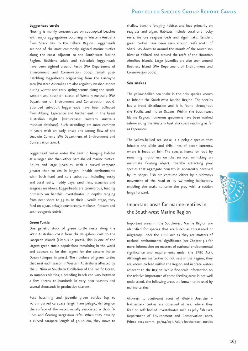
163
Protected Species Group Report Cards
Loggerhead turtle
Nesting is mainly concentrated on subtropical beaches
with major aggregations occurring in Western Australia
from Shark Bay to the Pilbara Region. Loggerheads
are one of the most commonly sighted marine turtles
along the coast adjacent to the South-west Marine
Region. Resident adult and sub-adult loggerheads
have been sighted around Perth (WA Department of
Environment and Conservation 2007). Small post-
hatchling loggerheads originating from the Gascoyne
area (Western Australia) are also regularly washed ashore
during winter and early spring storms along the south-
western and southern coasts of Western Australia (WA
Department of Environment and Conservation 2007).
Stranded sub-adult loggerheads have been collected
from Albany, Esperance and further east in the Great
Australian Bight (Naturebase: Western Australia
museum database). Such strandings are more common
in years with an early onset and strong flow of the
Leeuwin Current (WA Department of Environment and
Conservation 2007).
Loggerhead turtles enter the benthic foraging habitat
at a larger size than other hard-shelled marine turtles.
Adults and large juveniles, with a curved carapace
greater than 70 cm in length, inhabit environments
with both hard and soft substrata, including rocky
and coral reefs, muddy bays, sand flats, estuaries and
seagrass meadows. Loggerheads are carnivorous, feeding
primarily on benthic invertebrates in depths ranging
from near shore to 55 m. In their juvenile stage, they
feed on algae, pelagic crustaceans, molluscs, flotsam and
anthropogenic debris.
Green Turtle
One genetic stock of green turtle nests along the
West Australian coast from the Ningaloo Coast to the
Lacepede Islands (Limpus in press). This is one of the
largest green turtle populations remaining in the world
and appears to be the largest for the eastern Indian
Ocean (Limpus in press). The numbers of green turtles
that nest each season in Western Australia is affected by
the El Niño or Southern Oscillation of the Pacific Ocean,
so numbers visiting a breeding beach can vary between
a few dozens to hundreds in very poor seasons and
several thousands in productive seasons.
Post hatchling and juvenile green turtles (up to
30 cm curved carapace length) are pelagic, drifting on
the surface of the water, usually associated with drift-
lines and floating sargassum rafts. When they develop
a curved carapace length of 30-40 cm, they move to
shallow benthic foraging habitat and feed primarily on
seagrass and algae. Habitats include coral and rocky
reefs, inshore seagrass beds and algal mats. Resident
green turtles have been seen around reefs south of
Shark Bay down to around the mouth of the Murchison
River at Kalbarri and around the reefs of the Houtman
Abrolhos Islands. Large juveniles are also seen around
Rottnest Island (WA Department of Environment and
Conservation 2007).
Sea snakes
The yellow-bellied sea snake is the only species known
to inhabit the South-west Marine Region. The species
has a broad distribution and it is found throughout
the Pacific and Indian Oceans. Within the South-west
Marine Region, numerous specimens have been washed
ashore along the Western Australia coast reaching as far
as Esperance.
The yellow-bellied sea snake is a pelagic species that
inhabits the slicks and drift lines of ocean currents,
where it feeds on fish. The species hunts for food by
remaining motionless on the surface, mimicking an
inanimate floating object, thereby attracting prey
species that aggregate beneath it, apparently deceived
by its shape. Fish are captured either by a sideways
movement of the head or by swimming backwards,
enabling the snake to seize the prey with a sudden
lunge forward.
Important areas for marine reptiles in
the South-west Marine Region
Important areas in the South-west Marine Region are
identified for species that are listed as threatened or
migratory under the EPBC Act as they are matters of
national environmental significance (see Chapter 3.2 for
more information on matters of national environmental
significance and requirements under the EPBC Act).
Although marine turtles do not nest in the Region, they
are known to feed within the Region and in State waters
adjacent to the Region. While fine-scale information on
the relative importance of these feeding areas is not well
understood, the following areas are known to be used by
marine turtles:
Mid-west to south-west coast of Western Australia –
leatherback turtles are observed at sea, where they
feed on soft bodied invertebrates such as jelly fish (WA
Department of Environment and Conservation 2007,
Prince pers comm. 30/04/07). Adult leatherback turtles
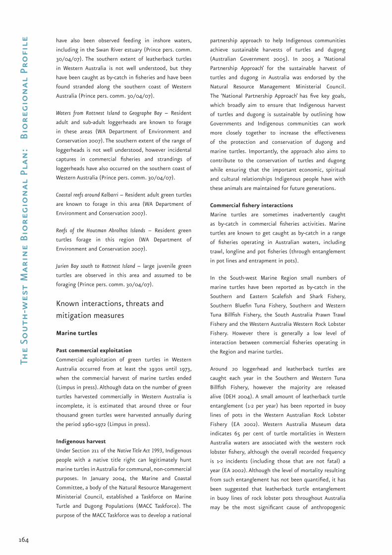
164
The
Sou
th-w
est
Mar
ine
Bio
regi
on
al P
lan
: B
iore
gio
nal
Pro
file have also been observed feeding in inshore waters,
including in the Swan River estuary (Prince pers. comm.
30/04/07). The southern extent of leatherback turtles
in Western Australia is not well understood, but they
have been caught as by-catch in fisheries and have been
found stranded along the southern coast of Western
Australia (Prince pers. comm. 30/04/07).
Waters from Rottnest Island to Geographe Bay – Resident
adult and sub-adult loggerheads are known to forage
in these areas (WA Department of Environment and
Conservation 2007). The southern extent of the range of
loggerheads is not well understood, however incidental
captures in commercial fisheries and strandings of
loggerheads have also occurred on the southern coast of
Western Australia (Prince pers. comm. 30/04/07).
Coastal reefs around Kalbarri – Resident adult green turtles
are known to forage in this area (WA Department of
Environment and Conservation 2007).
Reefs of the Houtman Abrolhos Islands – Resident green
turtles forage in this region (WA Department of
Environment and Conservation 2007).
Jurien Bay south to Rottnest Island – large juvenile green
turtles are observed in this area and assumed to be
foraging (Prince pers. comm. 30/04/07).
Known interactions, threats and
mitigation measures
Marine turtles
Past commercial exploitation
Commercial exploitation of green turtles in Western
Australia occurred from at least the 1930s until 1973,
when the commercial harvest of marine turtles ended
(Limpus in press). Although data on the number of green
turtles harvested commercially in Western Australia is
incomplete, it is estimated that around three or four
thousand green turtles were harvested annually during
the period 1960-1972 (Limpus in press).
Indigenous harvest
Under Section 211 of the Native Title Act 1993, Indigenous
people with a native title right can legitimately hunt
marine turtles in Australia for communal, non-commercial
purposes. In January 2004, the Marine and Coastal
Committee, a body of the Natural Resource Management
Ministerial Council, established a Taskforce on Marine
Turtle and Dugong Populations (MACC Taskforce). The
purpose of the MACC Taskforce was to develop a national
partnership approach to help Indigenous communities
achieve sustainable harvests of turtles and dugong
(Australian Government 2005). In 2005 a ‘National
Partnership Approach’ for the sustainable harvest of
turtles and dugong in Australia was endorsed by the
Natural Resource Management Ministerial Council.
The ‘National Partnership Approach’ has five key goals,
which broadly aim to ensure that Indigenous harvest
of turtles and dugong is sustainable by outlining how
Governments and Indigenous communities can work
more closely together to increase the effectiveness
of the protection and conservation of dugong and
marine turtles. Importantly, the approach also aims to
contribute to the conservation of turtles and dugong
while ensuring that the important economic, spiritual
and cultural relationships Indigenous people have with
these animals are maintained for future generations.
Commercial fishery interactions
Marine turtles are sometimes inadvertently caught
as by-catch in commercial fisheries activities. Marine
turtles are known to get caught as by-catch in a range
of fisheries operating in Australian waters, including
trawl, longline and pot fisheries (through entanglement
in pot lines and entrapment in pots).
In the South-west Marine Region small numbers of
marine turtles have been reported as by-catch in the
Southern and Eastern Scalefish and Shark Fishery,
Southern Bluefin Tuna Fishery, Southern and Western
Tuna Billfish Fishery, the South Australia Prawn Trawl
Fishery and the Western Australia Western Rock Lobster
Fishery. However there is generally a low level of
interaction between commercial fisheries operating in
the Region and marine turtles.
Around 20 loggerhead and leatherback turtles are
caught each year in the Southern and Western Tuna
Billfish Fishery, however the majority are released
alive (DEH 2004). A small amount of leatherback turtle
entanglement (1-2 per year) has been reported in buoy
lines of pots in the Western Australian Rock Lobster
Fishery (EA 2002). Western Australia Museum data
indicates 65 per cent of turtle mortalities in Western
Australia waters are associated with the western rock
lobster fishery, although the overall recorded frequency
is 1-2 incidents (including those that are not fatal) a
year (EA 2002). Although the level of mortality resulting
from such entanglement has not been quantified, it has
been suggested that leatherback turtle entanglement
in buoy lines of rock lobster pots throughout Australia
may be the most significant cause of anthropogenic

165
Protected Species Group Report Cards
mortality for the species in Australian waters (Limpus
in press). Ongoing monitoring programmes, based on
onboard observers, are now in place to better determine
the level of interaction between the Western Australian
Rock Lobster Fishery and leatherback turtles (EA 2002).
Petroleum industry
Lighting and flares associated with oil and gas facilities
have the potential to affect marine turtles. Marine turtle
hatchlings can be prone to disorientation from lighting
sources close to nesting beaches. While marine turtles
do not nest in the South-west Marine Region, impacts
on nesting beaches to the north of the Region have
the potential to affect marine turtle populations in the
Region.
An investigation of the affect of flares and facility
lighting on marine turtles in Western Australia has been
carried out. Preliminary results suggest that impacts
on marine turtle nesting beaches are determined in
part by the phase of the moon, with disorientation of
hatchlings greatest on new moon nights (EA 2003).
The other factor, indicated by the preliminary results
of this study is that the brightness and wavelengths
of the light sources also influence the degree to which
hatchling disorientation occurs (EA 2003).
The Recovery Plan for Marine Turtles in Australia indicates
that:
weathered petroleum, emanating from heavy
crude oil, has been observed to seal the mouth and
nostrils of turtles;
tar balls are also known to be mistaken for food
items by marine turtles; and
one incident in Australia of a marine turtle being
affected by weathered petroleum has been reported
(EA 2003).
Seismic activity
The response of turtles to sound varies with different
frequencies and intensities of the sound. Under
experimental conditions marine turtles can detect
low frequency noise and modify their behaviour or, at
least, demonstrate a startle response. Seismic testing
and explosive removals of platforms have been shown
to impact on marine turtles, particularly if the survey
runs over mating grounds or near nesting beaches
during breeding season. The use of soft start procedures
is required in areas within the distribution of marine
turtles under the Petroleum Submerged Lands (Management
of Environment) Regulations 1999 (EA 2003).
•
•
•
Marine debris
Plastic rubbish washed or blown from land into the sea,
fishing gear abandoned by recreational and commercial
fishers, and solid non-biodegradable floating materials
such as plastics disposed of by ships at sea are all
considered harmful marine debris. Marine debris was
listed as a key threatening process under the EPBC Act
in 2003 because of the threat it poses to all marine life,
and is an added danger to the survival of species listed
as threatened under the EPBC Act.
All marine turtles nesting in Australia are considered
to be threatened by marine debris (DEH 2003). Marine
turtles can be harmed by marine debris in two ways: by
entanglement in discarded fishing gear or by ingestion
of plastics. Some species of marine turtles, particularly
leatherbacks and loggerheads are known to mistake
plastic bags for jellyfish. Discarded fishing nets are a
particular problem for marine turtles, with a significant
number of entanglements occurring around Cape Arnhem
and in the Gulf of Carpentaria (DEH 2003).
The Australian Government is currently developing
a threat abatement plan that aims to minimise
the impacts of marine debris on threatened
marine species. Further information is available at
<www.environment.gov.au/biodiversity/threatened/
publications/marine-debris.html>.
Other threats to marine turtles
There are several other potential threats to marine turtle
populations identified in the Recovery Plan for Marine
Turtles in Australia (EA 2003). They include:
factors that reduce successful marine turtle nesting
are a threat to some populations of marine turtles.
However, there are no nesting sites within the
Region. These factors are: light pollution, tourism
and recreational activities, vehicle damage,
particularly where there is recreational four wheel
drive beach access, and faunal predation on marine
turtle eggs;
change in land use practices has been identified as
a potential threat to marine turtles. Land clearing,
urban and industrial development and their
associated management are issues for concern in
regard to water quality degradation, loss of sea
grass and other impacts on nesting habitats; and
training activities undertaken by the Department
of Defence, such as the use of explosives or landing
craft on nesting beaches, have the potential
to impact on marine turtles. An environmental
•
•
•
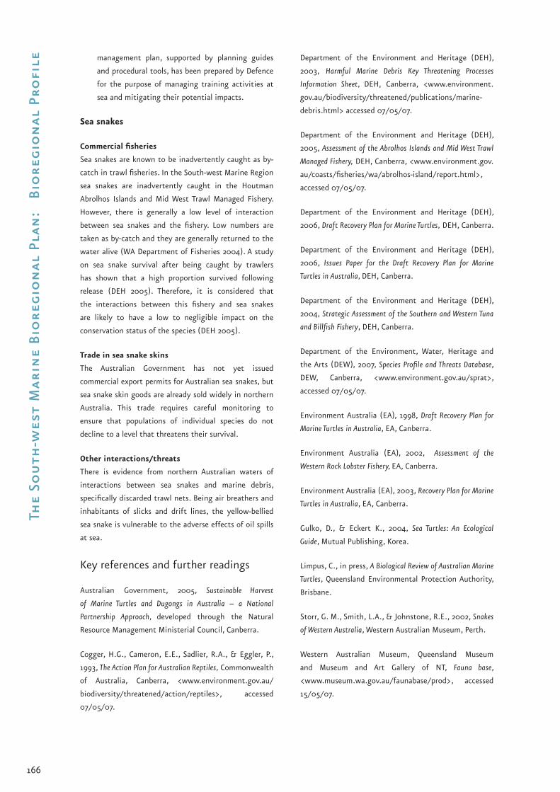
166
The
Sou
th-w
est
Mar
ine
Bio
regi
on
al P
lan
: B
iore
gio
nal
Pro
file management plan, supported by planning guides
and procedural tools, has been prepared by Defence
for the purpose of managing training activities at
sea and mitigating their potential impacts.
Sea snakes
Commercial fisheries
Sea snakes are known to be inadvertently caught as by-
catch in trawl fisheries. In the South-west Marine Region
sea snakes are inadvertently caught in the Houtman
Abrolhos Islands and Mid West Trawl Managed Fishery.
However, there is generally a low level of interaction
between sea snakes and the fishery. Low numbers are
taken as by-catch and they are generally returned to the
water alive (WA Department of Fisheries 2004). A study
on sea snake survival after being caught by trawlers
has shown that a high proportion survived following
release (DEH 2005). Therefore, it is considered that
the interactions between this fishery and sea snakes
are likely to have a low to negligible impact on the
conservation status of the species (DEH 2005).
Trade in sea snake skins
The Australian Government has not yet issued
commercial export permits for Australian sea snakes, but
sea snake skin goods are already sold widely in northern
Australia. This trade requires careful monitoring to
ensure that populations of individual species do not
decline to a level that threatens their survival.
Other interactions/threats
There is evidence from northern Australian waters of
interactions between sea snakes and marine debris,
specifically discarded trawl nets. Being air breathers and
inhabitants of slicks and drift lines, the yellow-bellied
sea snake is vulnerable to the adverse effects of oil spills
at sea.
Key references and further readings
Australian Government, 2005, Sustainable Harvest
of Marine Turtles and Dugongs in Australia – a National
Partnership Approach, developed through the Natural
Resource Management Ministerial Council, Canberra.
Cogger, H.G., Cameron, E.E., Sadlier, R.A., & Eggler, P.,
1993, The Action Plan for Australian Reptiles, Commonwealth
of Australia, Canberra, <www.environment.gov.au/
biodiversity/threatened/action/reptiles>, accessed
07/05/07.
Department of the Environment and Heritage (DEH),
2003, Harmful Marine Debris Key Threatening Processes
Information Sheet, DEH, Canberra, <www.environment.
gov.au/biodiversity/threatened/publications/marine-
debris.html> accessed 07/05/07.
Department of the Environment and Heritage (DEH),
2005, Assessment of the Abrolhos Islands and Mid West Trawl
Managed Fishery, DEH, Canberra, <www.environment.gov.
au/coasts/fisheries/wa/abrolhos-island/report.html>,
accessed 07/05/07.
Department of the Environment and Heritage (DEH),
2006, Draft Recovery Plan for Marine Turtles, DEH, Canberra.
Department of the Environment and Heritage (DEH),
2006, Issues Paper for the Draft Recovery Plan for Marine
Turtles in Australia, DEH, Canberra.
Department of the Environment and Heritage (DEH),
2004, Strategic Assessment of the Southern and Western Tuna
and Billfish Fishery, DEH, Canberra.
Department of the Environment, Water, Heritage and
the Arts (DEW), 2007, Species Profile and Threats Database,
DEW, Canberra, <www.environment.gov.au/sprat>,
accessed 07/05/07.
Environment Australia (EA), 1998, Draft Recovery Plan for
Marine Turtles in Australia, EA, Canberra.
Environment Australia (EA), 2002, Assessment of the
Western Rock Lobster Fishery, EA, Canberra.
Environment Australia (EA), 2003, Recovery Plan for Marine
Turtles in Australia, EA, Canberra.
Gulko, D., & Eckert K., 2004, Sea Turtles: An Ecological
Guide, Mutual Publishing, Korea.
Limpus, C., in press, A Biological Review of Australian Marine
Turtles, Queensland Environmental Protection Authority,
Brisbane.
Storr, G. M., Smith, L.A., & Johnstone, R.E., 2002, Snakes
of Western Australia, Western Australian Museum, Perth.
Western Australian Museum, Queensland Museum
and Museum and Art Gallery of NT, Fauna base,
<www.museum.wa.gov.au/faunabase/prod>, accessed
15/05/07.

167
Protected Species Group Report Cards
WA Department of Environment and Conservation,
2007, Marine Turtles in Western Australia,
<www.naturebase.net/content/view/2462/1401>,
accessed 07/05/07.
WA Department of Fisheries, 2004, Final Application to
Australian Government Department of the Environment and
Heritage on the Abrolhos Islands and Mid West Trawl Managed
Fishery Against the Guidelines for the Ecologically Sustainable
Management of Fisheries for Consideration Under Parts 13
and 13A of the Environment Protection and Biodiversity
Conservation Act 1999, <www.environment.gov.au/coasts/
fisheries/wa/abrolhos-island/pubs/abrolhos-island-mid-
west-trawl.pdf>, accessed 07/05/07.
WA Department of Fisheries, 2005, Bycatch in
Commercial Fisheries, <www.fish.wa.gov.au/docs/
pub/CommercialBycatch/index.php?0605>, accessed
07/05/07.

168
The
Sou
th-w
est
Mar
ine
Bio
regi
on
al P
lan
: B
iore
gio
nal
Pro
file D4 South-west Marine Region
Protected Species Group Report Card – Seabirds
Current at May 2007. For updates see
<www.environment.gov.au/coasts/mbp/south-west>.
General information
A wide range of birds are found in the Region. These
include seabirds, such as albatrosses and shearwaters,
which breed or forage in the Region; shorebirds, such
as sandpipers and plovers that only fly over the Region
during migration; and coastal birds, such as pelicans,
ospreys and white-bellied sea-eagles that may only
occasionally feed in the waters of the Region. Most of
the Region’s bird species spend the majority of their
time close to the shore, wading or feeding in coastal
waters. Some species, however, range widely, foraging
over thousands of kilometres, targeting fish over the
shelf and in the open ocean. This report card discusses
only seabirds, which are defined here as:
“Species of birds whose normal habitat and food source
is derived from the sea” (Surman & Nicholson 2006).
Further, this report card focuses on those seabirds that
are known to commonly occur in the South-west Marine
Region. Appendix C lists all bird species protected under
the EPBC Act that may infrequently occur in the South-
west Marine Region.
Nationally protected species
Of the 38 seabirds known to occur in the Region, 22 are
listed as threatened and/or migratory under the EPBC
Act (Table D4.1). These include species of: albatrosses,
petrels, shearwaters, noddies and terns. The seabird
species found within the Region are described in further
detail below.
Australia is also a signatory to four international
agreements for the conservation of migratory birds.
These agreements are:
the Agreement on the Conservation of Albatrosses and
Petrels (ACAP), a multilateral agreement that seeks
to conserve albatrosses and petrels by coordinating
international activity to mitigate known threats
to albatross and petrel populations. ACAP has been
developed under the auspices of the Convention on
the Conservation of Migratory Species of Wild Animals
(CMS) 1979;
the Agreement for the Protection of Migratory Birds and
their Environment between the Government of Australia
and the Government of Japan 1974 (JAMBA);
the Agreement for the Protection of Migratory Birds and
their Environment between the Government of Australia
and the People’s Republic of China 1986 (CAMBA); and
the Republic of Korea-Australia Migratory Bird Agreement
2006 (ROKAMBA). This agreement will come into
force in the second half of 2007.
•
•
•
•
Australian lesser noddy. Photo: WA Department of Environment and Conservation, Bert and Bab Wells.

169
Protected Species Group Report Cards
Table D4.1 Seabirds listed as threatened or migratory under the EPBC Act that are known to occur in the Region
Species Conservation Status Australian Government Conservation Plans and
Policies for the Species
Blue petrel (Halobaena caerulea)
Vulnerable, Marine Threat Abatement Plan for the Incidental Catch (or bycatch) of Seabirds During Oceanic Longline Fishing Operations (2006)
National Recovery Plan for Ten Species of Seabirds (2005)
National Recovery Plan for Ten Species of Seabirds – Issues Paper (2005)
Recovery Plan for Albatrosses and Giant-petrels (2001)
The Action Plan for Australian Birds (2000)
Threat Abatement Plan for the Incidental Catch (or bycatch) of Seabirds During Oceanic Longline Fishing Operations (1998)
•
•
•
•
•
•
Soft-plumaged petrel(Pterodroma mollis)
Vulnerable, Marine
White-chinned petrel(Procellaria aequinoctialis)
Migratory, MarineListed under CMS (Appendix II)
Southern giant petrel (Macronectes giganteus)
Endangered, Migratory, MarineListed under CMS (Appendix II)
Northern giant petrel (Macronectes halli)
Vulnerable, Migratory, MarineListed under CMS (Appendix II)
Wilson’s storm-petrel(Oceanites oceanicus)
Migratory, MarineListed under JAMBA
Sooty albatross (Phoebetria fusca)
Vulnerable, Migratory, MarineListed under CMS (Appendix II)
Southern royal albatross (Diomedea epomophora)
Vulnerable, Migratory, MarineListed under CMS (Appendix II)
Northern royal albatross (Diomedea sanfordi)
Endangered, Migratory, MarineListed under CMS (Appendix II as Diomedea epomophora)
Wandering albatross (Diomedea exulans)
Vulnerable, Migratory, MarineListed under JAMBA & CMS (Appendix II)
Black-browed albatross (Thalassarche melanophris)
Vulnerable, Migratory, MarineListed under CMS (Appendix II as Diomedea melanophris)
Indian yellow-nosed albatross (Thalassarche carteri)
Vulnerable, Migratory, MarineListed under CMS (Appendix II as Diomedea chlororhynchos)
Shy albatross (Thalassarche cauta)
Vulnerable, Migratory, MarineListed under CMS (Appendix II as Diomedea cauta)
Streaked shearwater(Calonectris leucomelas)
Migratory, MarineListed under CAMBA (as Puffinus leucomelas) & JAMBA
Sooty shearwater(Puffinus griseus)
Migratory, MarineListed under CAMBA & JAMBA
Wedge-tailed shearwater(Puffinus pacificus)
Migratory, MarineListed under JAMBA
Short-tailed shearwater(Puffinus tenuirostris)
Migratory, MarineListed under JAMBA
Flesh-footed shearwater, fleshy-footed shearwater(Puffinus cameipes)
Migratory, MarineListed under JAMBA
Bridled tern(Sterna anaethetus)
Migratory, MarineListed under CAMBA & JAMBA
Common noddy(Anous stolidus)
Migratory, MarineListed under CAMBA & JAMBA
Australian lesser noddy(Anous tenuirostris melanops)
Vulnerable, Marine
Arctic jaeger(Stercocarius parasiticus)
Migratory, MarineListed under JAMBA

170
The
Sou
th-w
est
Mar
ine
Bio
regi
on
al P
lan
: B
iore
gio
nal
Pro
file Ecology of protected seabird species in
the South-west Marine Region
As described in Chapter 2 of this Bioregional Profile,
the Region’s marine environment has a range of unique
environmental characteristics including nutrient rich
upwellings and sub-Antarctic water masses, as well as
areas dominated by tropical water currents and warm in-
shore areas. These characteristics create an environment
that supports a large number of seabird species. Adjacent
to the Region there are also many breeding sites,
particularly islands, which are under State jurisdiction.
Table D4.2 outlines the estimated proportion of some
Australian nesting seabird populations known to breed
on islands adjacent to the Region.
Table D4.2 The proportion of Australian seabird nesting
populations that breed in areas immediately adjacent to
the Region
Species Percentage Breeding
Australian lesser noddy 100
Great-winged petrel 100
Flesh-footed shearwater 72
Little shearwater 58*
Wedge-tailed shearwater 71
Sooty tern 72
Common noddy 66.7
Roseate tern 59.7
Bridled tern 50
(Surman & Nicholson 2006)
* 100 per cent of the south-west Australian subspecies of the little shearwater (Puffinus assimilis tunneyi) breeds adjacent to the Region.
Petrels
Seven species of petrels, including giant-petrels,
regularly visit the Region. The majority of petrels found
in the Region are winter migrants that breed on sub-
Antarctic islands. Petrels range widely for food within
the Region, feeding on small fish, cephalopods (octopus,
squid and cuttlefish) and crustaceans along the edge of
the continental shelf and over open waters. They are
often observed over offshore areas near the continental
shelf break.
The only petrel species that breeds adjacent to the
Region is the great-winged petrel with some 33 000
breeding pairs estimated to breed on the islands of the
Recherche Archipelago. This population is also the only
breeding population of great-winged petrels in Australia.
Storm-petrels
Five species of storm-petrels have been recorded in the
Region, with the only regular visitors being the white-
faced and Wilson’s storm-petrels. White-faced storm-
petrels breed throughout the Region as far north as
the Houtman Abrolhos Islands, with an estimated 160
000 pairs breeding adjacent to the Region (Ross et al.
1995). The other three species of storm-petrel observed
in the Region – Leach’s, grey-backed and black-bellied
– are considered vagrants. Storm-petrels feed on small
crustaceans and fish in the top few centimetres of the
sea.
Albatrosses
Although seven species of albatrosses are known to
feed in the Region there are no breeding populations
in or adjacent to the Region. Albatrosses typically feed
in offshore areas during the winter months, with most
observations along the edge of the continental shelf and
over open waters where they glide on thermal currents
and catch fish and cephalopod prey by diving into the
water.
Shearwaters
Eight species of shearwaters are regularly found within
the Region with four species (wedge-tailed, little,
flesh-footed, and the short-tailed) known to breed in
areas adjacent to the Region. The only rookeries of the
south-west Australian subspecies of the little shearwater
(Puffinus assimilis tunneyi) occur on islands off south-west
Western Australia with between 27 000 and 62 000
pairs recorded (Baker et al. 2002). About 104 000 pairs
of flesh-footed shearwaters breed on islands between
the South Australia border and Cape Leeuwin, while
West Wallabi Island, Pelsaert Island (within the Houtman
Abrolhos Islands) and Rottnest Island represent the most
important breeding sites in Australia for the wedge-
tailed shearwater. One million breeding pairs are known
to nest on West Wallabi, 75 000 pairs on Pelsaert Island,
and 5800 pairs on Rottnest Island (Surman & Nicholson
2006).
Terns
Fifteen species of terns have been recorded within the
Region. Of these, only the bridled, fairy, sooty, Caspian,
crested, lesser-crested and roseate terns regularly occur
within the Region. The Arctic and Antarctic terns are
irregular visitors, while the white tern and common tern
are vagrants. In contrast to albatrosses and petrels, most
terns feed in waters over the continental shelf, usually
in sight of land, preying on small to medium sized
fish, squid and, in some instances, pelagic hydrozoans

171
Protected Species Group Report Cards
(jellyfish), terrestrial insects and crustaceans (Surman &
Wooller 2003).
Noddies
Two species of noddy occur in the Region and both
breed in significant numbers. The Houtman Abrolhos
Islands support the only Australian breeding population
of Australian lesser noddies, which consists of about
68 000 pairs spread over three islands. The only other
breeding populations of this species occur in the
western Indian Ocean. The common noddy also has a
major breeding area on the Houtman Abrolhos Islands
(130 000 pairs; Dunlop et al. 2001) with a smaller
satellite population (less than 1000 pairs; Dunlop
2005) breeding on Lancelin Island. In Australian waters,
noddies breed annually during the autumn. During non-
breeding periods, lesser noddies tend to remain near
breeding sites. However, they can forage well out to sea
and have been observed hundreds of kilometres from
breeding sites and over open ocean. In contrast, the
common noddy moves away from breeding sites to feed
in tropical waters during non-breeding periods. Both
species forage for a diverse range of food including fish,
squid, pelagic molluscs and insects.
Gannets
Two species of gannets are found within the Region:
the cape gannet and the Australasian gannet, however,
only the Australasian gannet occurs regularly in the
Region. Gannets range across continental shelf waters
of southern Australia as far north as Cape Cuvier in
Western Australia. They feed on medium-sized fish and
cephalopods (such as squid and octopus) taken from
continental shelf waters. The Australasian gannet breeds
outside the Region in both Victoria and Tasmania. The
cape gannet was once thought not to breed in Australia,
but small numbers (seven pairs in 1994) have been
recorded breeding at an Australasian gannet colony on
Lawrence Rocks near Portland, in Victoria, and some
interbreeding between the two species has occurred
(Norman et al. 1998).
Tropicbirds
The red-tailed tropicbird is found breeding in very
small numbers on two islands adjacent to the Region
– Sugarloaf Rock (34 pairs in 1969, declining to around
15 at present) and up to three pairs intermittently on
Pelsaert Island (Surman & Nicholson 2006). Movements
and ecology away from the breeding sites are poorly
known with only a few sightings at sea. Interestingly,
the only banding recovery of a red-tailed tropicbird away
from the banding site was a bird from Sugarloaf Rock
that was recovered on Reunion Island in the Western
Indian Ocean – a movement of about 5000 km (Le Corre
et al. 2003).
Penguins
The little penguin is the only penguin species that
occurs regularly in the Region. The rockhopper, fiordland,
king and erect-crested penguins are considered vagrants
as they have only rarely been recorded in the Region.
The little penguin nests on islands along the coast from
Kangaroo Island to Perth, with approximately 3500 pairs,
representing 5 per cent of the total Australian breeding
population (Ross et al. 1995).
Important areas for seabirds in the
South-west Marine Region
Important areas in the South-west Marine Region are
identified for species listed as threatened or migratory
under the EPBC Act as they are matters of national
environmental significance (see Chapter 3.2 for more
information on matters of national environmental
significance and requirements under the EPBC Act).
Important feeding areas for seabirds are identified in the
South-west Marine Region and important rookeries are
identified in areas under the jurisdiction of the South
Australian and Western Australian Governments. The
important areas identified for seabirds include:
Houtman Abrolhos Islands – These islands have rookeries
for a number of species, including the bridled tern,
Caspian tern, common noddy, Australian lesser noddy
and wedge-tailed shearwaters. The Houtman Abrolhos
Islands are particularly important for the Australian
lesser noddy as it is the only place the species has
rookeries in Australia. About 68 000 pairs of Australian
lesser noddies currently breed on Morley and Wooded
Islands in the Easter Group, and Pelsaert Island in the
Pelsaert Group of the Houtman Abrolhos Islands, Western
Australia. The species is known to forage between the
islands and the continental shelf edge. The osprey and
the white-bellied sea eagle are also known to nest on
these islands (Pelsaert Island and West Wallabi Island
respectively). The common noddy has a rookery on
Pelsaert Island. Caspian terns nest in colonies of up to
70 pairs on Leo Island, West Wallabi Island and Pelsaert
Island. Bridled terns have rookeries on Gun Island, Leo
Island, Pelsaert Island and Little North Island.
Rottnest Island – Rookeries for wedge-tailed shearwaters
and bridled terns.

172
The
Sou
th-w
est
Mar
ine
Bio
regi
on
al P
lan
: B
iore
gio
nal
Pro
file Recherche Archipelago – Rookeries for flesh-footed
shearwaters, short-tailed shearwaters and Caspian Terns.
Nesting area for white-bellied sea eagles.
Penguin Island – Rookery for bridled terns.
Eyre Peninsula – Nesting area for ospreys and white-
bellied sea eagles.
Kangaroo Island – Nesting area for ospreys.
Lancelin Island – Rookeries for wedge-tailed shearwaters
and bridled terns.
Safety Bay – Rookeries for wedge-tailed shearwaters and
bridled terns.
Great Althorpe Island – Rookery for short-tailed
shearwaters.
Cape Hamelin – Rookery for flesh-footed shearwaters.
Yorke Peninsula – Nesting area for white-bellied sea
eagles.
Nuyts Archipelago (including Franklin, St Peter, Goat, Evans
and Massilon Islands) – Rookeries for Caspian terns, flesh-
footed shearwaters and short-tailed shearwaters.
Neptune Islands (including North and South Neptune) –
Rookeries for short-tailed shearwaters and Caspian terns.
Gambier Island – Rookeries for short-tailed shearwaters.
Lewis, Hopkins and Willaims Islands (near Cape Catastrophe)
– Rookeries for short-tailed shearwaters.
Greenly Island – Rookery for short-tailed shearwaters.
Investigator Group – Rookeries for short-tailed shearwaters.
West Troubridge Shoal – Rookery for Caspian terns.
Sir Joseph Banks Group – Rookeries for Caspian terns.
Eyre Island and Little Eyre Island – Rookeries for Caspian
terns.
Fisherman Islands – Rookeries for bridled terns.
Beagle Islands – Rookeries for bridled terns.
Known interactions, threats and
mitigation measures
At sea, seabirds may interact with human activities in
a number of ways, including encounters with fishing
vessels and entanglement in marine debris. Some
birds may also be affected by disturbance at rookeries
adjacent to the Region. These interactions are discussed
in more detail below.
Another potential threat to seabirds is climatic and
oceanic change (DEH 2005c). However given poor
knowledge of the oceanic distribution of most seabirds
it is difficult to assess the likely impact of climate
change on seabirds (DEH 2005d).
Commercial fisheries
Seabirds foraging for fish alongside commercial
fishing operations may interact with vessels in several
ways: birds may collide with trawl apparatus, become
entangled in nets, ingest discarded hooks or be caught
on longlines. In the South-west Marine Region, the
Western Australian-managed South Coast Purse Seine
Fishery has a high level of interaction with flesh-footed
shearwaters during their summer breeding season.
Estimates of the level of mortality during the three
month peak of the breeding season are around six birds
per day per boat (DEH 2005a). In 2003 there were
approximately 16 boats operating within this fishery
(Gardner et al. 2006). As part of the assessment of this
fishery under the EPBC Act, the Western Australian
Department of Fisheries is required to:
develop a monitoring programme to determine the
number of protected species being inadvertently
caught as by-catch;
develop specific performance measures and
indicators for interactions with flesh-footed
shearwaters and report annually on the performance
of the fishery at minimising seabird interactions;
and
trial mitigation mechanisms to minimise
protected/listed species interactions, particularly
with flesh-footed shearwaters and that measures
are implemented within six months of being
demonstrated effective (DEH 2005a).
The Southern and Western Tuna and Billfish Fishery
is also known to interact with a range of seabirds
including albatrosses, petrels and shearwaters, with the
capture of seabirds hooked and/or entangled during
setting or hauling of longlines. Between 1998 and
2002; 25 seabirds were reported as taken by longliners
operating within the fishery (DEH 2004a). Research
points to a mortality rate of seabirds captured of around
40 per cent. However, the Southern and Western Tuna
and Billfish Fishery is currently fishing at a low level of
effort compared with 2002 (Gardner et al. 2006). As a
•
•
•
173
Protected Species Group Report Cards
result, interactions with birds of the Region are likely to
have declined during the past few years.
Outside the Region, the Eastern Tuna and Billfish Fishery
– which operates in waters down the eastern seaboard
of Australia and off Tasmanian and Victoria out to the
edge of the EEZ – is known to interact with seabirds.
Given the foraging ranges of many of the bird species
occurring in the Region, this fishery has the potential
to interact with species that are also found within the
Region, particularly albatrosses. Since 2002, around
350 birds have been reported killed within the fishery
(DEH 2005b). During the year 2003-2004, a total of 32
seabirds were reported as taken by longliners operating
in the fishery with none released alive (DEH 2005b). The
main species caught were flesh-footed shearwater (16),
short-tailed shearwater (two), and a range of petrel and
albatross species (DEH 2005b).
In recognition of the threat posed to seabirds from
longline fishing, the incidental catch, or by-catch, of
seabirds during oceanic longline fishing operations is
listed under the EPBC Act as a key threatening process.
A Threat Abatement Plan for the Incidental Catch (or By-
catch) of Seabirds During Oceanic Longline Fishing Operations
is in place and available at <www.aad.gov.au/default.
asp?casid=20587>. In addition, By-catch Action Plans
have been developed to identify by-catch issues in
specific fisheries and to outline actions required to
address those issues. Mitigation measures include
the implementation of fishery observer programmes,
weighted lines and night-setting. Data are also collected
on the nature and extent of interactions and the range
of species involved, as well as on the effectiveness of
current management actions.
The trawl operations of the Region, such as the Great
Australian Bight Trawl Fishery1 and the Western
Deepwater Trawl, may also threaten the Region’s bird
species because birds can accidentally become caught
in nets. While there is some evidence, particularly from
overseas studies, that these types of interactions may
occur, the threat to seabirds in the Region by trawl
fisheries is considered low (DEH 2004b).
Marine debris
Plastic rubbish washed or blown from land into the sea,
fishing gear abandoned by recreational and commercial
fishers, and solid non-biodegradable floating materials
1 The Great Australian Bight Trawl Fishery is a sector of the Australian Government-managed Southern and Eastern Scalefish and Shark Fishery.
(such as plastics) disposed of by ships at sea are all
considered harmful marine debris. Marine debris islisted
as a key threatening process under the EPBC Act because
of the threat it poses to all marine life, especially to
species listed as threatened under the EPBC Act (DEH
2003).
The ingestion of, or entanglement in harmful marine
debris is recognised as a key threatening process
affecting seabirds (DEH 2003). Entanglement in marine
debris such as abandoned fishing lines, nets or other
debris can restrict mobility, reducing the ability of
seabirds to catch prey and avoid predators and lead to
increased mortality through starvation or drowning.
Entanglement can also constrict growth and circulation
resulting in infection or asphyxiation.
Plastic bags and other marine debris may be mistaken
for food items and ingested by seabirds. This can result
in a wide range of lethal and sub-lethal effects including
physical damage, perforation, blockage or impairment of
the digestive system. Some plastics are also a source of
toxic pollutants, which may lower fitness, thus reducing
the bird’s ability to reproduce successfully, catch prey
and avoid predators.
The Australian Government is currently developing
a threat abatement plan that aims to minimise
the impacts of marine debris on threatened
marine species. Further information is available at
<www.environment.gov.au/biodiversity/threatened/
publications/marine-debris.html>
Disturbance at rookeries
Introduced species are the most significant threat to
seabirds at their breeding sites. Species such as rabbits
may cause nest destruction and habitat modification,
while cats and rats can reduce reproductive success
through predation on eggs, chicks and breeding adults.
Disturbance by humans at nesting sites can also cause
breeding failure through nest destruction, nest desertion
or the inadvertent crushing of eggs or small chicks by
stressed adult birds.
174
The
Sou
th-w
est
Mar
ine
Bio
regi
on
al P
lan
: B
iore
gio
nal
Pro
file Key references and further reading
Baker, G.B., Gales, R., Hamilton, S., & Wilkinson, V.,
2002, ‘Albatrosses and Petrels in Australia: a Review of
their Conservation and Management’, Emu 102: 71-97.
Burbidge, A.A., Johnstone, R.E., & Fuller, P. J., 1996, The
Status of Seabirds in Western Australia, in The Status
of Australia’s Seabirds: Proceedings of the National Seabird
Workshop, Canberra, 1-2 November 1993: 57-71.
Department of the Environment and Heritage
(DEH), 2003a, Harmful Marine Debris Key Threatening
Processes Information Sheet, DEH, Canberra,
<www.environment.gov.au/biodiversity/threatened/
publications/marine-debris.html>, accessed 07/05/07.
Department of the Environment and Heritage (DEH),
2003b, Strategic Assessment of the Eastern Tuna and Billfish
Fishery, DEH, Canberra.
Department of the Environment and Heritage (DEH),
2004a, Assessment of the Southern and Western Tuna and
Billfish Fishery, DEH, Canberra.
Department of the Environment and Heritage (DEH),
2004b, Assessment of the Western Trawl Fisheries, DEH,
Canberra.
Department of the Environment and Heritage (DEH),
2005a, Assessment of the South Coast Purse Seine Managed
Fishery and the West Coast Purse Seine Managed Fishery, DEH,
Canberra.
Department of the Environment and Heritage (DEH),
2005b, Strategic Assessment of the Eastern Tuna and Billfish
Fishery, DEH, Canberra.
Department of the Environment and Heritage (DEH),
2005c, Recovery Plan for the following Seabirds: Round
Island Petrel – Pterodroma arminjoniana; Herald Petrel –
Pterodroma heraldica; Antarctic Tern (New Zealand) – Sterna
vittata bethunei; Antarctic Tern (Indian Ocean) – Sterna
vittata vittata; Blue Petrel – Halobaena caerulea; Fairy Prion
(southern) – Pachyptila tutur subantarctica; Heard Shag
– Phalacrocorax nivalis; Macquarie Shag – Phalacrocorax
purpurascens; Soft-plumaged Petrel – Pterodroma mollis;
Australian Lesser Noddy – Anous tenuirostris melanops 2005-
2010, DEH, Canberra.
Department of the Environment and Heritage (DEH,
2005d, Issues Paper: Population Status and Threats to Ten
Seabird Species Listed as Threatened under the Environment
Protection and Biodiversity Conservation Act 1999, DEH,
Canberra.
Department of the Environment, Water, Heritage and
the Arts (DEW), 2007, Species Profile and Threats Database,
DEW, Canberra, <www.environment.gov.au/sprat>,
accessed 07/05/07.
Dunlop, J.N., 2005, ‘The Demography of a New Common
Noddy (Anous stolidus) Colony During the Establishment
Period’, Emu 105: 99-104.
Dunlop, J.N., Surman, C.A., & Wooller, R.D., 2001, ‘The
Marine Distribution of Seabirds from Christmas Island,
Indian Ocean’, Emu 101: 19-24.
Gardner, S., Tonts M., & Elrick, C., 2006, A Socio-economic
Analysis and Description of the Marine Industries of Australia’s
South-west Marine Region, Department of the Environment
and Water Resources, Hobart.
Higgins, P.J., & Davies, S.J.J.F. (eds), 1996, Handbook of
Australian, New Zealand and Antarctic Birds, Volume Three
–Snipe to Pigeons, Oxford University Press, Melbourne.
Le Corre, M., Salamolard, M., & Portier, M.C., 2003,
‘Transoceanic Dispersion of the Red-tailed Tropicbird in
the Indian Ocean‘, Emu 103: 183-184.
Norman, F.I., Minton, C.D.T., Bunce, A., & Govanstone,
A.P., 1998, ‘Recent Changes in the Status of Australasian
Gannets Morus serrator in Victoria’, Emu 98: 147-150.
Ross, G. J.B., Burbidge, A.A., Brothers, N., Canty, P.,
Dann, P., Fuller, P.J., Kerry, K.R., Norman, F.I., Menkhorst,
P.W., Shaughnessy, G., Shaughnessy, P.D., Smith, G.C.,
Stokes, T., & Tranter, J.,1995, ‘The Status of Australia’s
Seabirds’,. in Zann, L., & Kailoa, P. (eds), Technical Annex 1,
State of the Marine Environment Report of Australia: 167-182,
Great Barrier Reef Marine Park Authority, Townsville.
Surman, C.A., & Wooller R.D., 2003, ‘Comparative
Foraging Ecology of Five Sympatric Terns at a Sub-
tropical Island in the Eastern Indian Ocean, Journal of
Zoology 259: 219-230.
Surman, C., & Nicholson, L., 2006, ‘Seabirds’ in
McClatchie, S., Middleton, J., Pattiaratchi, C., Currie,
D., & Kendrick, G. (eds), The South-west Marine Region:
Ecosystems and Key Species Groups, Department of the
Environment and Water Resources, Hobart.

175
Protected Species Group Report Cards
D5 South-west Marine Region Species Group Report Card – Pinnipeds
Current at May 2007. For updates see
<www.environment.gov.au/coasts/mbp/south-west>.
General information
Pinnipeds are part of the order Carnivora, which
includes the families: Otaridae (fur seals and sea lions);
Phocidea (true or earless seals); and the Odobenidae (the
walruses).
Of the 10 species of pinnipeds that occur in Australian
waters (which includes the Australian Antarctic Territory
and Heard and MacDonald Islands), three are known to
occur in the South-west Marine Region. These are the
Australian sea lion (Neophoca cinerea), the New Zealand
fur seal (Arctocephalus forsteri) and the Australian fur
seal (Arctocephalus pusillus). Another six species have
been recorded in the Region and are considered as
vagrant species. These are the southern elephant seal
(Mirounga leonine), the leopard seal (Hydrurga leptonyx),
the crabeater seal (Lobodon carcinophagus), the Weddell
seal (Leptonochotes weddellii), the Antarctic fur seal
(Arctocephalus gazella) and the sub-Antarctic fur seal
(Arctocephalus tropicalis).
Nationally protected species
All pinnipeds are protected as listed marine species
under Section 248 of the EPBC Act. Of the species of
pinniped occurring in the South-west Marine Region
only one, the Australian sea lion, is listed as a threatened
species (see Table D5). A recovery plan for this species is
currently under preparation.
Ecology of pinnipeds in the South-west
Marine Region
Australian sea lions
Australian sea lions are endemic to Australia and occur
in coastal habitats, waters and islands offshore of South
Australia and Western Australia. The species is one of
five sea lion species in the world. It has an estimated
population of fewer than 11 000 - 12 000 individuals
(Goldsworthy et al. 2006).
While the current range of the Australian sea lion
extends to the Houtman Abrolhos Islands in Western
Australia, most of the population is found in South
Australia. The species ‘hauls-out’ (or rests) and breeds
on rocks and sandy beaches on the sheltered sides of
islands, although there are some small colonies on the
Australian mainland. Australian sea lions are relatively
easily seen at colonies on islands adjacent to the Region
and are the focus of nature-based tourism enterprises.
The current distribution of the Australian sea lion largely
falls within the Region and adjacent State waters.
Prior to sealing, the species was known to have a more
extensive range. Australian sea lions have an unusually
long breeding cycle – 17 to 18 months – and the timing
of cycles varies between closely situated breeding
sites (different colonies breed at different times). The
Australian sea lion is unique among pinnipeds in being
the only species that has a non-annual breeding cycle
and that also breeds at different times across its range
(Goldsworthy et al. 2006). Female Australian sea lions
also show strong breeding site fidelity. Recent population
genetic studies have indicated little or no interchange
of female Australian sea lions among breeding colonies,
even those separated by short distances (McKenzie
et al. 2005). These breeding characteristics make the
Australian sea lion particularly vulnerable to disturbance
by humans (DAFF 2007).
Table D5 Pinnipeds listed as threatened under the EPBC Act that are known to occur in the Region
Species Conservation Status Australian Government Conservation Plans and
Policies for the Species
Australian sea lion
(Neophoca cinerea)
Vulnerable
Marine
The Action Plan for Australian Seals (1999)
National Strategy to Address Interactions between Humans and Seals:
Fisheries, Aquaculture and Tourism (November 2006)
National Assessment of Interactions between Humans and Seals:
Fisheries, Aquaculture and Tourism (2007)
•
•
•

176
The
Sou
th-w
est
Mar
ine
Bio
regi
on
al P
lan
: B
iore
gio
nal
Pro
file Australian sea lions feed on the continental shelf in
the Region, most commonly in depths of 20-100 m
(Shaughnessy 1999). They appear to be mainly benthic
foragers (Goldsworthy et al. 2006) and eat a wide variety
of prey including fish, small sharks, invertebrates (such
as rock lobster), cephalopods (octopus, squid, cuttlefish
and nautilus) and occasionally seabirds.
New Zealand fur seals
New Zealand fur seals breed in the Region on rocky
islands off South Australia and the southern coast of
Western Australia. They also breed on the south-west
coast of Tasmania and on some offshore islands in
Victoria. More than 80 per cent of Australia’s population
of New Zealand fur seals occur in South Australia
(Goldsworthy et al. 2006). In Western Australia, the
population of this species appears to be recovering to
the size and range that occurred prior to commercial
hunting, as they are occupying new breeding sites and
extending their range westwards. The species is also
found at many locations around New Zealand’s rocky
coastline, mostly on the southern shores of the country’s
South Island and on many of the offshore and sub-
Antarctic islands (Seal Conservation Society n.d.). New
Zealand fur seals are relatively easily seen in the Region
and are the subject of targeted tourism enterprises.
There are about 51 known breeding sites for this
species in Australia with most in South Australia (30)
and Western Australia (17). Large breeding populations
adjacent to the Region are found at North and South
Neptune Islands, Kangaroo Island and Liguanea
Island, and account for more than 80 per cent of the
national pup production for the species (Goldsworthy
et al. 2006). New Zealand fur seal colonies in Western
Australia are centred on the islands of the Recherche
Archipelago, with the westernmost population near Cape
Leeuwin. Available information suggests that the range
of this species is expanding in Western Australia, with an
increasing number of animals hauling out and breeding
on the south-west coast (Goldsworthy et al. 2006).
New Zealand fur seals feed at the surface to depths
generally not exceeding 200 m and eat mainly fish and
cephalopods (DAFF 2007). Lactating female New Zealand
fur seals feed predominantly in mid to outer continental
shelf waters. The males feed in deeper waters of the
continental shelf, while juveniles forage in oceanic
waters (Goldsworthy et al. 2006).
Figure D5.1 Australian sea lion breeding sites in the South-west Marine Region (South Australia)

177
Protected Species Group Report Cards
Australian fur seals
Australian fur seals do not breed in the Region but are
reasonably common in the eastern part of the Region
where the species feeds and hauls out (Goldsworthy et
al. 2006). They are known to haul-out among and near
to New Zealand fur seal colonies on Kangaroo Island and
are sometimes seen around the Neptune Islands.
Like Australian sea lions, Australian fur seals feed mainly
in the waters of the shelf and are known to dive to at
least 164 m. Australian fur seals are generally benthic
foragers, which is unusual for a fur seal. They take a
wide variety of prey, particularly fish, squid, cuttlefish
and octopus (DAFF 2007).
Important areas for pinnipeds in the
South-west Marine Region
Important areas in the South-west Marine Region are
identified for species listed as threatened or migratory
under the EPBC Act as they are matters of national
environmental significance (see Chapter 3.2 for more
information on matters of national environmental
significance and requirements under the EPBC Act).
The Australian sea lion is the only species of pinniped
listed as threatened under the EPBC Act with breeding
colonies adjacent to the Region.
There are 73 known breeding locations for Australian
sea lions (47 colonies in South Australia and 26 colonies
in Western Australia) (McKenzie et al. 2005). However,
Goldsworthy et al. (2006) report the presence of
Australian sea lion pups at 76 sites over the past 20 years
in the Region (48 in South Australia and 28 in Western
Australia). Most of these colonies are found on islands
adjacent to the South-west Marine Region. Five of the
known Australian sea lion breeding colonies produce
more than 100 pups each year, representing more than
50 per cent of all pups born (McKenzie et al. 2005).
These five sites are all in South Australia: Dangerous
Reef (Southern Eyre Peninsula), the Pages Islands
(which is adjacent to the South-east Marine Region),
West Waldegrave Island (Western Eyre Peninsula),
Seal Bay (Kangaroo Island), and Olive Island (Western
Eyre Peninsula) (McKenzie et al. 2005). Because of the
closed breeding patterns of Australian sea lions and
their conservation status as a threatened species it is
considered that all breeding sites for Australian sea
lions are significant. Figure D5.1 and Figure D5.2 show
the locations of Australian sea lion breeding colonies in
South Australia and Western Australia respectively.
Figure D5.2 Australian sea lion breeding sites in the South-west Marine Region (Western Australia)

178
The
Sou
th-w
est
Mar
ine
Bio
regi
on
al P
lan
: B
iore
gio
nal
Pro
file Known interactions, threats and
mitigation measures
The Australian sea lion, Australian fur seal and New
Zealand fur seal populations were substantially reduced
in the eighteenth, nienteenth and early twentieth
centuries as a result of commercial sealing. While fur seal
populations show some evidence of recovery since the
cessation of commercial sealing, there is limited data to
confirm the extent of recovery (DAFF 2007).
There is limited historic information on the size
and range of Australian sea lion populations prior
to European colonisation. However, before sealing,
the range of Australian sea lions was more extensive
(McKenzie et al. 2005). Although the Australian sea lion
was eliminated from parts of its range, the lower prices
for Australian sea lion skins and the difficulties involved
in accessing small, isolated populations meant that
sealing activity had a lesser impact on Australian sea
lion populations than on fur seal populations (McKenzie
et al. 2005).
Activities in the Region with the most potential to
impact on pinnipeds if not managed appropriately
include commercial fishing, aquaculture activities,
tourism activities and through interactions with marine
debris and pollution.
Commercial fisheries
Interactions with fisheries are an important issue for
the conservation and management of seals and sea lions
in Australia. The impacts on pinnipeds from commercial
fishing relate mainly to entanglement in nets and death
by drowning through capture or entanglement in fishing
gear. Additional and less well understood impacts relate
to potential trophic or ecological interactions between
seals and fisheries operations.
Fishery by-catch and entanglement have been identified
as factors contributing to limited growth in some
populations of Australian sea lions (McKenzie et al.
2005).
Interactions between seals or sea lions and fisheries
in Commonwealth waters in the Region occur mainly
in the Commonwealth Southern and Eastern Scalefish
and Shark Fishery, the South and Western Australian
Rock Lobster Fisheries, and the Southern Bluefin Tuna
Aquaculture Fishery in South Australia. There are many
anecdotal and some documented reports of pinnipeds
being caught and drowned incidentally in trawl fishing
operations (Shaughnessy 1999).
Trawl fishing operations: A 15 year study on Kangaroo
Island estimated that a minimum of 64 Australian
sea lions die each year in southern Australia from
entanglement with fishing gear (McKenzie et al. 2005).
Australian fur seals, and to a lesser extent, New Zealand
fur seals, have been reported to interact with the
Commonwealth Trawl Sector of the Southern and Eastern
Scalefish and Shark Fishery (DAFF 2007; DEH 2006).
Australian fur seals, New Zealand fur seals and Australian
sea lions have been reported to interact with the Gillnet
Hook and Trap Sector of the Southern and Eastern
Scalefish and Shark Fishery. The known interactions
that are detrimental to seals and sea lions are incidental
capture in gillnets that may lead to death by drowning
or injury; and entanglement in fishing gear such as trawl
nets, monofilament nets, nylon ropes, and bait straps
and bait containers (DAFF 2007).
Australian fur seal. Photo: Graham Blight, CSIRO.

179
Protected Species Group Report Cards
A number of measures are in place in the Southern and
Eastern Scalefish and Shark Fishery to mitigate effects
on marine species. There is an inshore closure of the
fishery in South Australian waters from the head of the
Great Australian Bight to the Western Australian border,
to minimise fishing impacts on large breeding-age
sharks, white sharks and Australian sea lions (DEH 2006).
An industry-based Fisheries Research and Development
Corporation funded project has trialled measures to
promote comprehensive reporting of seal interactions in
the trawl sectors of the Southern and Eastern Scalefish
and Shark Fishery (DEH 2006). There is direction to
install seal excluder devices in mid-water trawl nets
in the winter blue grenadier fishing component of the
Commonwealth Trawl Sector of the Southern and Eastern
Scalefish and Shark Fishery (DEH 2006). A mandatory
requirement to fit seal excluder devices to mid water
trawl nets in the winter blue grenadier processing/
freezing component of the Commonwealth Trawl Sector
of the Southern and Eastern Scalefish and Shark Fishery
was implemented in 2005 (AFMA 2006).
The Assessment of the Southern and Eastern Scalefish
and Shark Fishery done under the EPBC Act in 2006
also specifies the need for the Australian Fisheries
Management Autority to:
develop and implement further measures to verify
the extent and type of interactions with protected
species in the fishery, with priority given to sea
lions and fur seals;
give priority to developing specific mitigation
measures to reduce fishing impacts on sea lions
and fur seals across the sectors of the fishery (DEH
2006).
Pot fishing operations: There are instances of
Australian sea lion pups and juveniles being caught and
drowning in lobster pots of the Western Rock Lobster
and South-coast Crustacean fisheries in Western Australia
and the Rock Lobster Fishery in South Australia. While
the encounter and mortality rate of Australian sea
lion pups in these fisheries is likely to be a rare event
(McKenzie et al. 2005), the large number of pots and
the small size of most Australian sea lion populations,
particularly on the west coast of South Australia, means
that even these low levels may have adverse population
effects. The South Australian Department of Primary
Industries and Resources is giving priority to quantifying
and mitigating seal interactions in the South Australia
Rock Lobster Fishery (DEH 2003a).
•
•
Ongoing monitoring programmes using onboard
observers are in place in the Western Rock Lobster
Fishery (EA 2002). The data from these programmes
and from fishery logbooks is being used to validate
the ranking of threat level to the Australian sea lion
population from the fishery (EA 2002). In an effort to
reduce seals and sea lions’ interactions with lobster
pots, bait protection and seal exclusion devices have
been developed and are being introduced into the rock
lobster fisheries. A number of different sea lion exclusion
device designs are being tested and implemented in
some parts of the Western Rock Lobster Fishery by the
Western Australian Department of Fisheries (McKenzie
et al. 2005).
Deliberate killing
Although hunting is illegal, there have been a number of
anecdotal reports of the shooting of Australian sea lions
by commercial fishers and past reports of occasional
shooting and harassing of seals around tuna aquaculture
farms. Five Australian sea lions were known to be
shot in the Port Lincoln area between 1995 and 2000
(McKenzie et al. 2005). The most common unnatural
causes of death recorded in stranded Australian sea
lions in Western Australia between 1980 and 1996 were
shootings (14 animals), with a further three deaths
resulting from spearing or shooting with arrows and one
death due to clubbing (McKenzie et al. 2005). There is
little information on the mortality of Australian sea lions
from illegal shooting and therefore it is not possible to
assess the impact of this interaction on the recovery of
Australian sea lion populations (McKenzie et al. 2005).
Aquaculture
Finfish aquaculture farms are known to pose a threat to
seals and sea lions (DAFF 2007). The known interactions
that are detrimental are entanglement in fish-farm nets
and entrapment in fish cages resulting in injury and
possibly death to the seals. Fatal entanglement of seals
can occur in anti-predator nets, and illegal killing of
seals and Australian sea lions near finfish operations has
been reported (DAFF 2007).
Seals and Australian sea lions are known to interact with
the activities and infrastructure of tuna farms near Port
Lincoln in South Australia. A low number of Australian
sea lions were recorded entangled and drowned in anti-
predator nets used in the southern bluefin tuna feed lots
in the Port Lincoln area in South Australia in the 1990s.
The industry has reported that the use of anti-predator
nets and improved farm management has greatly
reduced seal interactions. However, there is a paucity

180
The
Sou
th-w
est
Mar
ine
Bio
regi
on
al P
lan
: B
iore
gio
nal
Pro
file of data on interactions between seals and Australian sea
lions and marine finfish aquaculture farms as there are
no formal observer programmes operating on marine
finfish aquaculture farms (McKenzie et al. 2005).
Because of the lack of an observer programme, details
of the current level and nature of interactions between
pinnipeds and marine finfish aquaculture in the Region
is unknown.
Tourism
There is the potential for seal and sea lion populations
to be disturbed by tourism and recreational activities,
particularly populations of the more vulnerable Australian
sea lion during breeding seasons (McKenzie et al. 2005;
DAFF 2007). Tourism activities that could potentially
affect seals and Australian sea lions are boat cruises,
swimming, snorkelling and scuba diving with seals, and
land-based viewing of seal colonies. Human disturbance
of seals and Australian sea lions can lead to mortalities
and injuries, especially to pups. However no research is
available to date on the long-term impact of disturbance
by humans on population growth of Australian sea lions
or establishment of breeding colonies (McKenzie et al.
2005).
Tourism based activities occur at Australian sea lion
breeding colonies and haul-out sites in Western Australia
and in South Australia. In Western Australia, tourism
activities at Australian sea lion colonies occur in the
Perth region, the Jurien Bay area and at colonies along
the south coast in the Recherche Archipelago near
Esperance. In South Australia, tourism activities at
Australian sea lion, Australian fur seal and New Zealand
fur seal colonies occur at Baird Bay, Kangaroo Island (two
locations), Neptune Island, Point Labatt; Encounter Bay,
Rapid Bay, and on islands in the Spencer Gulf. In Western
Australia, Australian fur seals are viewed at Bunker Bay,
Flinders Islet, St Alouran Island Nature Reserve and Seal
Island Nature Reserve (off Albany), and Seal Rock and
Doubtful Island Nature Reserve (off Bremer Bay).
Commercial seal watching by tourists at locations
on Kangaroo Island (Cape de Coudedic and Seal Bay
Conservation Park) in South Australia is a threat to
specific colonies, particularly as visitor numbers increase
(Shaughnessy 1999). Efforts have been made at the
largest of these sites, Seal Bay on Kangaroo Island, to
regulate tourism activities to keep people away from
breeding sites. The long-term nature of tourism activities
at these sites is believed to have caused the Australian
sea lions at these sites to have a higher than usual level
of tolerance for the presence of humans, which may be
mitigating the potential for negative impacts on the
population.
Marine debris and contaminants
Rubbish washed or blown from land into the sea, fishing
gear abandoned by recreational and commercial fishers,
and solid non-biodegradable floating materials such as
plastics disposed of by ships at sea are all considered to
be harmful marine debris. Marine debris was listed as
a key threatening process under the EPBC Act in 2003
because of the threat it poses to all marine life, and
is an added danger to the survival of species listed as
threatened under the EPBC Act.
Seals and Australian sea lions interact with human-made
marine debris including ‘ghost nets’ (which are discarded,
free-floating fishing nets), rubber rings from bait boxes,
ropes and plastic bags. This can result in strangulation
as a result of plastic or net fragments becoming
entangled around the necks of seals and sea lions. It can
also lead to starvation, or death by predation, because
of reduced mobility from entanglement. Records of
entanglements on Kangaroo Island indicate that both
New Zealand fur seals and Australian sea lions interact
with marine debris that is likely to have been lost from
the commercial Southern Rock Lobster Fishery, including
plastic straps that surround cardboard boxes of bait,
and rope from rock lobster pot floats (McKenzie et al.
2005). In Western Australia the Department of Fisheries
has undertaken to educate and encourage fishers in
the Western Australian Rock Lobster Fishery to bring
all waste back to port, in part to reduce the threat of
Australian sea lions becoming entangled in bait bands
(EA 2002). In recognition of possible threats to seals,
the South Australian Southern Rock Lobster industry has
been phasing out the use of bait supplied in packaging
that requires strapping.
The Australian Government is also currently
developing a threat abatement plan that aims to
minimise the impacts of marine debris on threatened
marine species. Further information available at
<www.environment.gov.au/biodiversity/threatened/
publications/marine-debris.html>.
Marine pollution
Oil spills and chemical contaminants are a known threat
to Australian pinniped species. Many of the seal and
sea lion colonies in the Region occur close to major
shipping lanes and are therefore vulnerable to oil spills
in the event of shipping accidents. However, there
is no evidence to date that pollution and toxins are
significant factors currently impacting the growth of

181
Protected Species Group Report Cards
fur seal or Australian sea lion populations. The sinking
of the bulk ore carrier, the ‘Sanko Harvest’ off Esperance
in 1991 led to oil fouling of fur seal pups in at least two
breeding colonies in Western Australia. The degree to
which this fouling, and the ensuing clean-up, affected
fur seal mortality or reproductive performance is not
known (Gales pers. comm. 23/02/07; DAFF 2007).
Other potential threats
There are several other potential threats to pinniped
species identified in recent literature, including:
the release back into the wild of rehabilitated
(from disease) and stranded pinnipeds, may pose
a threat as a vector of disease in healthy, wild
populations of seals. However, information on the
type of disease agents and their prevalence in seal
populations throughout Australia is limited;
the effect of seismic activity for petroleum
exploration on pinnipeds is not well understood,
but could possibly impact on prey availability
in feeding grounds for seals if not adequately
managed; and
a number of whole-of-ecosystem factors, which
may inhibit the recovery of Australian sea lion
populations. These are climate change, constraints
on food availability and loss of foraging habitat
through degradation (DEH 2005).
Key references and further reading
Australian Fisheries Management Authority (AFMA),
2006, Southern and Eastern Scalefish and Shark Fishery
Wildlife Trade Operation Re-assessment 2006, Australian
Government,Canberra.
Browne, A., Welsford, D., & Lyle, J., 2005, Monitoring
Marine Mammal Interactions in the Small Pelagics Fishery:
Stage One Pilot Study, report to the Australian Fisheries
Management Authority, Tasmanian Aquaculture and
Fisheries Institute, University of Tasmania, Hobart.
Department of Agriculture, Fisheries and Forestry
(DAFF), 2006, National Strategy to Address Interactions
between Humans and Seals: Fisheries, Aquaculture and Tourism,
DAFF, Canberra.
Department of Agriculture, Fisheries and Forestry
(DAFF), 2007, National Assessment of Interactions between
Humans and Seals: Fisheries, Aquaculture and Tourism, DAFF,
Canberra.
•
•
•
Department of the Environment and Heritage (DEH),
2003a, Assessment of the South Australian Rock Lobster
Fishery, DEH, Canberra.
Department of the Environment and Heritage
(DEH), 2003b, Harmful Marine Debris Key Threatening
Processes Information Sheet, DEH, Canberra,
<www.environment.gov.au/biodiversity/threatened/
publications/marine-debris.html>, accessed 07/05/07.
Department of the Environment and Heritage (DEH),
2005, Draft Recovery Plan for the Australian Sea Lion.
Department of the Environment and Heritage, Canberra,
<www.environment.gov.au/biodiversity/threatened/
publications/recovery/n-cinerea/pubs/n-cinerea-draft-
recovery.pdf>, accessed 07/05/07.
Department of the Environment and Heritage (DEH),
2006, Assessment of the Southern and Eastern Scalefish and
Shark Fishery, DEH, Canberra.
Environment Australia (EA), 2002, Assessment of the
Western Rock Lobster Fishery, EA, Canberra.
Goldsworthy, S. Campbell R., & McKenzie, J., 2006,
‘Pinnipeds’, The South-west Marine Region: Ecosystems
and Key Species Groups, in McClatchie, S., Middleton,
J., Parriaratchi, C., Currie, D., & Kendrick, G. (eds),
Department of the Environment and Water Resources,
Canberra pp. 386-389.
McKenzie, J., Goldsworthy, S.D., Shaughnessy, P.D., &
McIntosh, R., 2005, Understanding the Impediments to the
Growth of Australian Sea Lion Populations, South Australian
Research and Development Institute (Aquatic Sciences),
Adelaide.
Seal Conservation Society, n.d., New Zealand Fur Seal,
<www.pinnipeds.org/species/nzfursl.htm> accessed
14/04/07.
Shaughnessy, P.D., 1999, The Action Plan for Australian
Seals, Environment Australia, Canberra.

182
The
Sou
th-w
est
Mar
ine
Bio
regi
on
al P
lan
: B
iore
gio
nal
Pro
file Map data
Figure D5.1 Australian sea lion breeding sites in the South-west Marine Region (South Australia)Department of the Environment, Water, Heritage and the Arts (2004):Collaborative Australian Protected Areas Database – CAPADDepartment of the Environment, Water, Heritage and the Arts (2006):Commonwealth Marine Planning RegionsDepartment of the Environment, Water, Heritage and the Arts (2006):Integrated Marine and Coastal Regionalisation of Australia v4.0 - Provincial BioregionsDepartment of the Environment, Water, Heritage and the Arts (2006): Species of National Environmental Significance DatabaseGeoscience Australia (1998): Australia, TOPO-2.5M Topographic DataGeoscience Australia (2004): Gazetteer of AustraliaGeoscience Australia (2005): Australian Bathymetry and TopographyGeoscience Australia (2006): Australian Maritime Boundaries (AMB) v2.0Projection: Geographics, Datum: GDA94Produced by the Environmental Resources Information Network (ERIN) Australian Government Department of the Environment, Water, Heritage and the Arts. COPYRIGHT Commonwealth of Australia, 2007.
Figure D5.2 Australian sea lion breeding sites in the South-west Marine Region (Western Australia)Department of the Environment, Water, Heritage and the Arts (2004):Collaborative Australian Protected Areas Database – CAPADDepartment of the Environment, Water, Heritage and the Arts (2006):Commonwealth Marine Planning RegionsDepartment of the Environment, Water, Heritage and the Arts (2006):Integrated Marine and Coastal Regionalisation of Australia v4.0 - Provincial BioregionsDepartment of the Environment, Water, Heritage and the Arts (2006): Species of National Environmental Significance DatabaseGeoscience Australia (1998): Australia, TOPO-2.5M Topographic DataGeoscience Australia (2004): Gazetteer of AustraliaGeoscience Australia (2005): Australian Bathymetry and TopographyGeoscience Australia (2006): Australian Maritime Boundaries (AMB) v2.0Projection: Geographics, Datum: GDA94Produced by the Environmental Resources Information Network (ERIN) Australian Government Department of the Environment, Water, Heritage and the Arts. COPYRIGHT Commonwealth of Australia, 2007.

183
Protected Species Group Report Cards
D6 South-west Marine Region Protected Species Group Report Card – Cetaceans
Current at May 2007. For updates see
<www.environment.gov.au/coasts/mbp/south-west>.
General information
Globally, the order Cetacea comprises more than 80
species of marine mammals known as whales, dolphins
and porpoises. There are two extant sub-orders. These
are:
the Mysticeti, or baleen whales, which are
distinguished by their generally large size (8-30 m);
twin blowholes; and keratinous baleen plates that
hang from the upper jaw and are used to filter out
schooling prey such as crustaceans and small fish;
and
the Odontoceti, or toothed whales, which are more
diverse and extremely variable in size (1.5 - 18 m);
have a single blowhole; and true teeth for holding
prey, which are usually individually caught. Most
species have well-developed echo-location (Gill et
al. 2006).
Of the 45 cetacean species recorded in Australian waters,
31 are known to occur in the South-west Marine Region.
A further nine species may occur infrequently in the
Region.
Nationally protected species
All cetaceans are protected under the EPBC Act by
virtue of their listing as ‘cetacean’ and the establishment
of the Australian Whale Sanctuary. Nine species of
cetacean found in the Region are listed as threatened
and/or migratory (Table D6). Additionally, the long-
snouted spinner dolphin is considered a ‘priority species’
under the 1996 Action Plan for Australian Cetaceans
although information is still too scarce to assign it to a
conservation category (Ross 2006).
Ecology of protected cetaceans in the
South-west Marine Region
Cetaceans found in the South-west Marine Region
include both inshore and offshore species as well as
a mix of Southern Ocean species (for example, blue
whales, southern right whales, and southern right
•
•
whale dolphins) and species associated with warmer
tropical waters (for example, short-finned pilot whales,
and striped and spinner dolphins). Use of the Region’s
marine habitats and resources varies broadly among
cetaceans. Some species are rarely sighted in the Region,
others migrate annually from Antarctic waters into the
Region while others are found throughout the year and
are thought to be permanent residents of the Region.
Southern right whales migrate from their summer
feeding grounds in the Southern Ocean to calve and
breed in the warmer waters of the Region, and females
in particular appear to have strong fidelity to breeding
sites. Humpback whales traverse the Region every
year between their tropical and sub-tropical breeding
areas, and their feeding areas in the Antarctic. Other
species, such as the long-finned pilot whale and the
killer whale, move across very large distances and are
observed in the Region occasionally, possibly at times
when their preferred prey is more abundant. Common
and bottlenose dolphins are resident in the Region
throughout the year and are frequently observed. Finally,
some species, like the pygmy right whale and beaked
whales, are known to inhabit the Region but have
been observed only rarely due possibly to their ‘cryptic’
behaviour.
Some highly visible species, such as the southern
right and humpback whales, do not usually feed in the
Region, and so may play only a minor ecological role
within their breeding and migratory habitats. However,
most species of cetaceans, including pygmy blue whales,
regularly feed in the Region’s waters. Sperm, pilot and
beaked whales are likely to forage along the upper
slope and in canyons, while pelagic dolphins appear
to aggregate in response to seasonal fish production.
Collectively, cetaceans are likely to be significant
predators of a number of prey groups, including squid,
myctophids such as lantern fish, clupeids (sardines and
herrings), and crustaceans including euphausiids (krill),
amphipods and copepods. However, until it is possible
to estimate trophic requirements as well as predator
and prey population size and dynamics, the exact nature
and extent of their ecological role remains unclear. The
biomass of all the large whale species (with the possible
exception of sperm whales; Gill et al. 2006) is still greatly
reduced from past whaling activity and it is thought
that much greater numbers were supported within the
Region prior to commercial whaling.

184
The
Sou
th-w
est
Mar
ine
Bio
regi
on
al P
lan
: B
iore
gio
nal
Pro
file Table D6 Cetaceans listed as threatened or migratory under the EPBC Act that are known to occur in the South-west
Marine Region
Species Conservation Status Australian Government Conservation Plans and
Policies for the Species
Southern right whale (Eubalaena australis)
Endangered, Migratory
Listed under CITES (Appendix I) and CMS
(Appendix I)
Recovery Plan for Australia’s Threatened Whales 2005-2010: Humpback,
Southern Right Whale, Blue, Fin and Sei (2005)
Australian National Guidelines for Whale and Dolphin Watching (2005)
Guidelines on the application of the Environment Protection and Biodiversity
Conservation Act to interactions between offshore seismic operations and
larger cetaceans (2001)
The Action Plan for Australian Cetaceans (1996)
Blue whale* (Balaenoptera musculus)
Endangered, Migratory
Listed under CITES (Appendix I) and CMS
(Appendix I)
Sei whale (Balaenoptera borealis)
Vulnerable, Migratory
Listed under CITES (Appendix I) and CMS
(Appendix I & II)
Fin whale (Balaenoptera physalus)
Vulnerable, Migratory
Listed under CITES (Appendix I) and CMS
(Appendix I & II)
Humpback whale (Megaptera novaeangliae)
Vulnerable, Migratory
Listed under CITES (Appendix I) and CMS
(Appendix I)
Bryde’s whale (Balaenoptera edeni)
Migratory
Listed under CITES (Appendix I) and CMS
(Appendix II)
Pygmy Right whale (Caperea marginata)
Migratory
Listed under CITES (Appendix I) and CMS
(Appendix II)
Killer whale, orca (Orcinus orca)
Migratory
Listed under CITES (Appendix II) and
CMS (Appendix II)
Sperm whale (Physeter macrocephalus)
Migratory
Listed under CITES (Appendix I) and CMS
(Appendix I & II)
* The taxonomy of blue whales is unclear, however it is generally accepted that there are two sub-species in the Southern Hemisphere: the ‘true’ Antarctic blue whale, Brevicauda musculus intermedia, and the pygmy blue whale, B. m. brevicauda. Both these sub-species are thought to occur in the South-west Marine Region, although their respective distributions are uncertain. One notable difference is that during the Southern Hemisphere summer, ‘true’ blues are usually found south of 60ºS, while ‘pygmy’ blues are usually found north of 55ºS. Blue whales are listed under the EPBC Act at the species level, however, where possible, this report card distinguishes between sub-species. Where sub-species cannot be identified, both sub-species are referred to collectively as ‘blue whales’.
Important areas for cetaceans in the
South-west Marine Region
Important areas in the South-west Marine Region
are identified for cetaceans listed as threatened or
migratory under the EPBC Act as they are matters of
national environmental significance (see Chapter 3.2 for
more information on matters of national environmental
significance and requirements under the EPBC Act).
Important feeding areas, calving areas and resting
areas are identified for cetaceans listed as threatened
or migratory under the EPBC Act. Some of these areas
are within the South-west Marine Region, while others
are under the jurisdiction of the South Australian and
Western Australian Governments. The important areas
identified for cetaceans listed as threatened or migratory
under the EPBC Act include:
The Great Australian Bight – This area is of particular
significance for southern right whales with one of the
main calving areas in South Australia at the Head of
Bight.
Doubtful Islands Bay – This area is one of the main calving
areas for southern right whales in Western Australia.
East of Israelite Bay – This area is one of the main calving
areas for southern right whales in Western Australia.
Fowlers Bay – This is one of the main calving areas for
southern right whales in South Australia.
Albany/ Cape Riche area – This is one of the main calving
areas for southern right whales in Western Australia.

185
Protected Species Group Report Cards
Yokinup Bay/Cape Arid area – This is one of the main
calving areas for southern right whales in Western
Australia.
Perth Canyon – The Perth Canyon is a seasonally
important aggregation area for krill at depths of 200-
300 m and attracts many species of krill feeders, in
particular pygmy blue whales. Fin whales have been
observed in the area and it is thought that sei whales
may also feed there.
Waters from Geographe Bay to Rottnest Island – The bay and
surrounding waters are an important resting area for
humpback whales, particularly cow-calf pairs, as they
migrate south at the end of the breeding season. Recent
surveys have also detected southern right whales in the
area. Research in recent years has shown an increasing
number of blue whales using the bay in spring and also
passing through the shelf area between Cape Naturaliste
and Rottnest Island, however the ecological or functional
significance of the area to the species is unclear.
Waters to the south of Kangaroo Island – This area is a
feeding area for pygmy blue whales, fin whales, sperm
whales and possibly sei whales.
Waters adjacent to the Houtman Abrolhos Islands – This area
is a resting site for humpback whales on migration.
Sightings of Bryde’s whales also suggest this area may
be important for this rarely sighted species;
Waters surrounding Cape Leeuwin/Flinders Bay – This is a
resting area for humpback whales.
Encounter Bay – This is one of the main calving areas for
southern right whales in South Australia.
Twilight Cove – This is one of the main calving areas for
southern right whales in Western Australia.
Albany Canyons Group and adjacent shelf break – This area
is a feeding area for sperm whales. Sperm whales have
been recorded as concentrated in a narrow area only a
few miles wide at the shelf edge off Albany, Western
Australia (Bannister et al. 1996).
Apart from the specific areas identified above, other
features of the Region’s marine environment are thought
to be important to some cetaceans. There is some
evidence to suggest that canyons in the continental
slope, such as the Ceduna Canyons and the Perth
Canyon, are aggregation areas for fish, krill and deep-
sea cephalopods (squids, octopus and cuttlefish). It is
also thought that these aggregations may be important
food sources for sperm whales, beaked whales, and
krill-eating fish, which, in turn, may be preyed upon
by pelagic dolphins. Strandings of Gray’s beaked whales
in Geographe Bay may suggest that nearby areas may
be important for this species, however, little is known
about this species presence in the Region. In the
Great Australian Bight area, pinniped colonies may be
important feeding grounds for killer whales although
this requires further investigation.
Diving whale. Photo: Robert Thorne, Department of the Environment, Water, Heritage and the Arts.

186
The
Sou
th-w
est
Mar
ine
Bio
regi
on
al P
lan
: B
iore
gio
nal
Pro
file Figure D6.1 Important areas for southern right, humpback and blue whales in the South-west Marine Region
Known interactions, threats and
mitigation measures
During the early 1800s, whaling was an important
industry in the Region. Semi-permanent camps were set
up on the Eyre Peninsula, Kangaroo Island, the Esperance
area of Western Australia and as far north as Shark Bay,
to target a range of the larger whale species. Over-
exploitation and dramatic declines in whale numbers
eventually led to the demise of the whaling industry.
Australia’s last whaling station, at Cheynes Beach near
Albany, closed in 1978. In 1979, Australia adopted an pro-
conservation policy, putting a permanent end to whaling
in Australian waters.
Although there has been a global moratorium on
commercial whaling effective since 1986, populations
of all species are still below pre-whaling estimates
– most considerably so. Two populations of targeted
species have been recovering – the southern right
whale and the west coast population of the humpback
whale are increasing at rates close to their respective
biological capacity. While not a current threat to most
species, whaling is still listed as the most threatening
anthropogenic activity in all five threatened cetacean
recovery plans under the EPBC Act. Antarctic minke
whales, which may migrate past Australian shores, are
the primary target of ‘scientific’ whaling by Japan. In
addition to 850 minke whales, 50 humpback and 50 fin
whales are proposed to be taken under Japan’s Antarctic
Research Programme, JARPA II, during the 2007/08
summer.
Under the EPBC Act, all cetaceans are protected within
the Australian Whale Sanctuary, and measures are
in place to mitigate potential negative impacts of
human actions on whale and dolphin species. However,
interactions between cetaceans and humans do occur
in Australian waters. Most of these interactions
are accidental as they do not result from activities
deliberately aiming to interact with cetaceans.
Collecting information on feeding habits, migration
routes and preferred habitats is important in preventing
significant incidental interactions with cetaceans.
Behavioural differences between species also influence
the likelihood of interactions, with some cryptic species,
like the Bryde’s whales, being rarely encountered.
Activities in the Region with the most potential to
impact on cetaceans if not managed appropriately
include commercial fishing, oil and gas exploration
and development, defence activities, shipping, human
maritime and shore sourced pollution, recreational
boating and whale/dolphin watching activities.

187
Protected Species Group Report Cards
Commercial fisheries
Interactions between cetaceans and fisheries can include
competition for target species, depredation of catch,
entanglement by cetaceans in gear, or injury or death
through incidental capture.
Information on trophic interactions between cetaceans
and fisheries is limited. Work on marine mammals
generally indicates that cetaceans at the top of the food
chain may have a significant effect on the structure of
the marine ecosystem. Competition between cetaceans
and fisheries may be direct, where both are targeting
a common prey species, or indirect through complex
trophic interactions. In particular, fisheries targeting
small pelagic species, such as pilchards and redbait, may
have a significant effect on some cetacean species as
small pelagic fish are thought to be important to many
components of the marine ecosystem generally. In the
South-west Marine Region, these fisheries are likely to
be competing with common and bottlenose dolphins.
Competition for targeted species can lead to direct
interactions between cetaceans and fisheries.
Depredation or the ‘robbing’ of fish caught on longlines,
by species such as killer whales and pilot whales, may
be a problem in some Australian longline fisheries,
especially tuna fisheries, which increases the threat of
entanglements, injuries and incidental by-catch (AFMA
2005a).
Although not associated with depredation, humpback
whales and southern right whales have also been
known to become entangled in fishing gear during
their annual migration. In the past 20 years, more
than 40 entanglements have been reported with the
majority occurring in floating lines of the Western Rock
Lobster Fishery (Keys 2007). The problem is expected to
increase as the whale populations recover. An industry
protocol has been developed to reduce pot rope lengths
to minimise the possibility of interactions with whales
and a code of conduct is in also in place to assist the
industry reduce the threat of entanglements. Most
instances of entanglement result in the whales being
released alive.
Species such as bottlenose and common dolphins may
interact with a range of fisheries in the Region through
incidental capture. In the South-west Marine Region,
by-catch of dolphins has been reported in the Australian
Government-managed Southern and Eastern Scalefish
and Shark Fishery and the South Australian-managed
Sardine Fishery.
In the gillnet sector of the Australian Government-
managed Southern and Eastern Scalefish and Shark
Fishery, 10 dolphin mortalities were recorded over a two-
year period (DEH 2003). Measures including observer
programmes and improved collection of incidence
data were subsequently put in place to better quantify
interactions with cetaceans and other protected species
(DEH 2006).
In 2005, the South Australian Department of Primary
Industries and Resources closed the South Australian-
managed Sardine Fishery for four weeks after dolphins
were killed in pilchard nets. The fishery was reopened
once the Department implemented ongoing monitoring
of interactions with protected and endangered species
through an independent observer programme (DEH
2004a).
By-catch of dolphins in waters outside the Region, which
may reduce the populations of dolphins in the Region,
has also occurred in the Australian Government-managed
Small Pelagics Fishery and the West Australian-managed
Pilbara Trawl Fishery. Dolphin by-catch in the Australian
Government-managed Small Pelagics Fishery in waters
around Tasmania resulted in 14 dolphin mortalities being
recorded in 2004 (AFMA & DEH 2005) and a further 11
dolphin mortalities in 2005 despite a suite of mitigation
measures being implemented (SPFMAC 2005). A Natural
Heritage Trust project was set in place with joint
partners the Australian Fisheries Management Authority,
the Department of the Environment and Heritage, the
operator, the Whale and Dolphin Conservation Society
and the Tasmanian Aquaculture and Fisheries Institute
to trial underwater cameras and mitigation methods.
However, no further interactions with dolphins have
been recorded (AFMA 2005b).
In 2005, the West Australian-managed Pilbara Trawl
Fishery, which operates in waters to the north of the
South-west Marine Region, captured 56 dolphins, of
which 52 died as a result (WA Department of Fisheries
2006). By-catch reduction grids are now being trialled
in the Fishery and a By-catch Action Plan is being
developed (WA Department of Fisheries 2006).
Aquaculture/mariculture
Aquaculture activities and equipment located adjacent
to the Region may be a source of interaction with
cetacean species, particularly smaller whales and
dolphins, often with negative results. Dolphins are
attracted by the feed-types used in tuna farms and are
regularly caught, and sometimes die, in aquaculture
nets. Between 1990 and 1999, at least 29 common and

188
The
Sou
th-w
est
Mar
ine
Bio
regi
on
al P
lan
: B
iore
gio
nal
Pro
file spotted bottlenose dolphins were reported to have
died from becoming entangled in southern bluefin tuna
feedlots at Port Lincoln (Kemper & Gibbs 2001).
Petroleum exploration
Oil and gas exploration and other geophysical surveys
involve the use of seismic ‘air-guns’, which generate a
rapid release of air under high pressure. Seismic surveys
have the potential to cause physical, behavioural
and perceptual effects on whales. Seismic surveys
are thought to cause cetaceans to detour away from
migration routes or from feeding or breeding areas.
Extremely close encounters may cause damage to their
ears.Baleen whales such as humpback, blue and fin
whales may be more affected by seismic surveys than
toothed whales as their acoustic range is thought to
operate in the same frequency as air gun pulses used in
seismic exploration. Seismic operations are regulated by
the Australian Government’s Guidelines on the Application of
the Environment Protection and Biodiversity Conservation Act
to Interactions between Offshore Seismic Operations and Larger
Cetaceans (EA 2001). These guidelines have just been
revised and are currently available for public comment at:
<www.environment.gov.au/epbc/publications/seismic>.
The petroleum industry has taken an active role in
the development and implementation of measures
to minimise the potential impacts of exploration on
cetaceans. The industry seeks to undertake exploration,
where practicable, during times when encounters with
whales are generally least likely to occur.
Defence activities
Within the Region, and particularly within the
Western Australian Exercise Area (WAXA) off Perth, the
Department of Defence conducts a range of activities
such as target practice and the use of active sonar to
locate targets that involves the use of live ammunition
within the marine environment. While the use of live
ammunition in the marine environment may be an issue
specific to training areas, to date most research on the
interaction of defence activities and cetaceans centres
around the use of active sonar devices and their effect
on cetaceans. Noise from some types of military sonar
has been linked elsewhere to strandings and deaths in
some species of deep-diving beaked whales. To date,
there is no evidence of whale strandings linked to
defence training activities within WAXA or any other
Australian training area.
In order to mitigate any impacts on cetaceans the
Royal Australian Navy has developed procedures for
detecting whales during defence training activities.
These procedures provide advice for operators of
military aircraft and equipment and naval vessels
that produce sonar or sources of underwater sounds
such as explosions. The Department of Defence, in
cooperation with the Department of the Environment,
Water, Heritage and the Arts, develops guidelines when
planning activities in the marine environment. These
guidelines provide advice on any approval required
from the Australian Government and how to avoid
any interactions with migrating, breeding and feeding
whales. However, for some species, beaked whales
in particular, interactions are difficult to mitigate as
these species spend very little time at the surface. The
effectiveness of visual detection to initiate mitigation
measures is probably limited for these species. To better
understand its obligations, the Department of Defence
has also provided financial, technical and material
support to a range of research activities related to
cetaceans. Most research in the Region has focused on
the Perth Canyon and blue whales, and has investigated
the ecology of the whales and the habitat attributes of
the canyon.
Shipping
Shipping is a major activity in the Region’s waters,
transporting goods through the Region and to and from
the ports in the Region. Ship strikes are likely to affect
the larger whale species such as blue, humpback and the
southern right whales, and result in an unknown number
of injuries and deaths within the Region. Overseas
studies indicate that ship strikes may be a major cause
of mortality for some cetacean species. Of the 45 known
mortalities of the northern right whales that occurred
within the North Atlantic between 1970 and 1999, 36
per cent were the result of ship strikes (Knowlton &
Kraus 2001). Care should be taken with these figures in
the Australian context because there is far more shipping
activity in the North Atlantic than in the waters of the
South-west Marine Region.
Marine debris
Plastic garbage washed or blown from land into the sea,
fishing gear abandoned by recreational and commercial
fishers, and solid non-biodegradable floating materials
(such as plastics) disposed of by ships at sea are all
considered to be harmful marine debris. Marine debris
is listed as a key threatening process under the EPBC
Act because of the threat it poses to all marine life,
especially to species listed as threatened under the EPBC
Act.

189
Protected Species Group Report Cards
Marine debris may contribute to the death of cetaceans,
with plastic bags being a known problem. For example,
a Bryde’s whale stranded near Cairns in August 2000
was found to have almost 6 m2 of plastic in its stomach
<www.environment.gov.au/coasts/publications/
cetacean-poster.html>. In addition, fishing gear such as
lost nets and pots from international waters may enter
the Region and cause whales to become entangled.
The Australian Government is currently developing
a threat abatement plan which aims to minimise
the impacts of marine debris on threatened
marine species. Further information is available at
<www.environment.gov.au/biodiversity/threatened/
publications/marine-debris.html>.
Whale watching
Recreational and tourism activities have the potential
to affect the behaviour of cetaceans. Because of their
presence in shallower coastal waters in the Region,
species such as southern right and humpback whales
and some species of dolphin may be susceptible
to disturbance from tourism operations. Potential
disturbance centres around behavioural changes due to
the proximity of vessels and/or aircraft.
In response to concerns regarding the impact on
whales and dolphins of the growing cetacean watching
industry, the Australian Government and all State and
Territory governments jointly developed the Australian
National Guidelines for Whale and Dolphin Watching (DEH
2006b). These guidelines apply equally to commercial and
recreational whale watching and have the dual aims of:
minimising harmful impacts on whales, dolphins
and porpoises; and
ensuring that people have the best opportunity to
enjoy and learn about the whales, dolphins and
porpoises found in Australian waters.
The guidelines set out a number of requirements of
relevance to both commercial and recreational whale
and dolphin watching, including minimum distance
requirements for vessels, aircraft and helicopters.
State Governments manage the day-to-day activities
of the cetacean watching tourism sector in State
waters, and their management arrangements are
consistent with the national guidelines. The Australian
Government implemented the latest National
Guidelines into the EPBC Regulations in June 2006
<www.environment.gov.au/coasts/publications/whale-
watching-guidelines-2005.html>.
•
•
Recreational activities
Recreational boating may also affect cetaceans through
direct strikes resulting in injury or death, physical
disturbance, or noise that can disturb cetaceans and
mask the acoustic cues on which they depend for
communication, orientation or food-finding.
Offshore installation
Offshore installations such as wind farms or wave
generators are currently under assessment overseas for
their potential to impact on cetaceans.
Aircraft
Aircrafts may disturb whales and dolphins due to their
speed, noise, shadow or, downdraft in the case of
helicopters. Provisions for the operation of aircraft in
the vicinity of whales and dolphins are outlined in the
Australian National Guidelines for Whale and Dolphin Watching
2005.
Land-based activities
Closer inshore, animals such as inshore bottlenose
dolphins may be locally at threat from disturbance
by humans, habitat modification or toxic pollution.
Organochlorines are synthetic compounds that are
commonly used in insecticides and enter the marine
ecosystem through soil erosion and agricultural run-off.
While usually only found at very low concentrations
in seawater, they can accumulate up the food chain to
toxic levels (EA 2002). Organochlorines are soluble in
fat and heavy doses may be passed to offspring through
mother’s milk. Concentrations of organochlorines and
other toxic contaminants such as heavy metals have
been found in marine mammals throughout the world,
including sperm whales off Tasmania, and in dolphins off
South Australia (Correll et al. 2004, Evans et al. 2004).
It is thought that organochlorines and other toxins may
have deleterious effects on the immune, endocrine and
nervous systems of cetaceans, and that such effects may
contribute to mass mortality events and strandings.
Climate change
The long-term effects of global warming on marine
species are still speculative, however it is predicted that
there will be reduced productivity of Southern Ocean
ecosystems and unpredictable weather events caused by
increasing ocean temperatures, changing ocean currents,
rising sea levels and reductions in sea ice (DEH 2005).
The Recovery Plan for Australia’s Threatened Whales indicates
that humpacks, southern right, blue, fin and sei whales
may be affected by habitat loss and reduction in food
availability. Whale migration, feeding and calving site
selection may be influenced by ocean currents and
190
The
Sou
th-w
est
Mar
ine
Bio
regi
on
al P
lan
: B
iore
gio
nal
Pro
file water temperature and changes to these factors could
affect cetacean populations by rendering current habitat
unsuitable (DEH 2005). Similarly, changes to climate
and oceanographic processes may lead to reduced
productivity and different patterns of prey distribution
and availability (DEH 2005). Changes in krill biomass in
particular could result in significant reductions in food
for baleen whales.
Cetacean strandings adjacent to the Region
The relationship between stranding events and human
activities is not well understood. Possible natural causes
of whale strandings include disease, injury, ocean
currents and topographical features of the coastline.
Pollution, ship strikes and anthropogenic marine noise
have also been suggested as contributing to strandings
(for example, Engel et al. 2004, Laist et al. 2001).
Since 1984 there have been 21 mass strandings of whales
and dolphins along the coast of Western Australia. The
majority of these have taken place in the State’s south-
west, in particular along a stretch of coastline between
Busselton and Augusta.
Along the coast of South Australia, the most common
animals to strand are bottlenose and common dolphins.
Other species of cetacean that have multiple stranding
records are strap-toothed beaked whale, sperm whale,
minke whale, long-finned pilot whale and pygmy sperm
whales.
The South Australian Museum and associates are carrying
out long-term studies on the carcasses of dead cetaceans
from South Australia with about 10 animals collected
from the Great Australian Bight region each year. These
studies are important for the conservation of cetaceans
as they provide vital details on cetacean life history,
distribution, taxonomy, pathology, toxic contaminant
loads and incidence of entanglement and intentional
killing.
Key references and further reading
Australian Fisheries Management Authority (AFMA),
2005a, Mammal Depredation on Demersal Longlines: A review
prepared by AFMA for the Gillnet, Hook and Trap Fishery,
Australian Government, Canberra.
Australian Fisheries Management Authority (AFMA),
2005b, Small Pelagic Fishery Management Advisory Committee
02, Australian Government, Canberra.
Australian Fisheries Management Authority (AFMA)
Small Pelagic Fishery Management Advisory Committee,
unpub. 2005, Meeting papers from SPFMAC 30
September 2005, Australian Government, Canberra,
<www.afma.gov.au/fisheries/small_pelagic/mac/2005/
m20050930/item2024_research.pdf>, accessed 07/05/07.
Australian Fisheries Management Authority (AFMA) and
Department of the Environment and Heritage (DEH),
2005, Report on the Incidents of Dolphin Deaths which
Occurred During Fishing Operations Off Eastern Tasmania,
Australian Government, Canberra, <www.afma.gov.au/
fisheries/small_pelagic/rag/2005/11_30_spf_cetacean_
20report_20final.pdf>, accessed 15/05/07.
Bannister, J.L., 1979-2005, Annual Reports on Aerial Surveys
of Southern Right Whales on the Southern Australian Coastline,
Western Australian Museum, Perth.
Bannister J.L., Kemper, C.M., & Warneke, R.M., 1996,
The Action Plan for Australian Cetaceans, Australian Nature
Conservation Agency, Canberra.
Burnell, S.R., 1999, The Population Biology of Southern Right
Whales in Southern Australian Waters, PhD thesis, University
of Sydney, Sydney.
Correll, R., Müller, J., Ellis, D., Prange, J., Gaus, C.,
Shaw, M., Holt, E., Bauer, U., Symons, R., & Burniston,
D., 2004, Dioxins in Fauna in Australia, National Dioxins
Program Technical Report No. 7, Australian Government
Department of the Environment and Heritage, Canberra.
Department of Fisheries Western Australia, 2006, A Draft
Bycatch Action Plan for the Pilbara Fish Trawl Interim Managed
Fishery, Department of Fisheries Western Australia,
Perth, <www.fish.wa.gov.au/docs/op/PilbaraTrawl/
DraftPilbaraTrawl.pdf>, accessed 07/05/07.
Department of the Environment and Heritage (DEH),
2002, Assessment of the Western Rock Lobster Fishery, DEH,
Canberra.
Department of the Environment and Heritage (DEH),
2003, Assessment of the Southern and Eastern Scalefish and
Shark Fishery, DEH, Canberra.
Department of the Environment and Heritage (DEH),
2004a, Assessment of the South Australian Pilchard Fishery,
DEH, Canberra.

191
Protected Species Group Report Cards
Department of the Environment and Heritage (DEH),
2004b, Strategic Assessment of the Southern and Western Tuna
and Billfish Fishery, DEH, Canberra.
Department of the Environment and Heritage (DEH),
2005, Recovery Plans 2005-2010 for Australia’s Threatened
Whales: Humpback, Southern Right, Blue, Fin and Sei, DEH,
Canberra.
Department of the Environment and Heritage (DEH),
2006, Assessment of the Southern and Eastern Scalefish and
Shark Fishery, DEH, Canberra.
Department of the Environment and Heritage
(DEH), 2006b, Australian National Guidelines for
Whale & Dolphin Watching 2005, DEH, Canberra,
<www.environment.gov.au/coasts/publications/
whalewatching-guidelines-2005.html> accessed
07/05/07.
Department of the Environment, Water, Heritage and
the Arts (DEW), 2007, Species Profile and Threats Database,
DEW, Canberra, <www.environment.gov.au/sprat>,
accessed 07/05/07.
Department of the Environment, Water, Heritage and
the Arts (DEW), 2007, Draft EPBC Act Policy Statement 2.1
Interaction between offshore seismic exploration and whales,
DEW, Canberra, <www.environment.gov.au/epbc/
publications/seismic>, accessed 13/07/07.
Engel, M.H., Marcondes, M.C.C., Martins, C.C.A., O Luna,
F., Lima, R. P., & Campos, A., 2004, Are Seismic Surveys
Responsible for Cetacean Strandings? An Unusual Mortality
of Adult Humpback Whales in Abrolhos Bank, Northeastern
Coast of Brazil, Paper submitted to the IWC Scientific
Committee (SC/56/E28).
Environment Australia (EA), 2001, Guidelines on the
Application of the Environment Protection and Biodiversity
Conservation Act to Interactions Between Offshore Seismic
Operations and Larger Cetaceans, EA, Canberra.
Environment Australia (EA), 2002, The Framework for
Marine and Estuarine Water Quality Protection, EA, Canberra.
Evans, K., Hindell, M. & Hince, G., 2004, ‘Concentrations
of Organochlorines in Sperm Whales (Physeter
macrocephalus) from Southern Australian Waters’, Marine
Pollution Bulletin 48: 486-503.
Gill, P., Burton, C., & Morrice, M., 2006, ‘Cetaceans’, in
McClatchie, S., Middleton, J., Pattiaratchi, C., Currie,
D., & Kendrick, G. (eds), The South-west Marine Region:
Ecosystems and Key Species Groups, Department of the
Environment, Water, Heritage and the Arts, Canberra.
Kemper, C.M., & Gibbs, S.E., 2001, ‘Dolphin Interactions
with Tuna Feedlots at Port Lincoln, South Australia
and Recommendations for Minimising Entanglements’,
Journal of Cetacean Research and Management 3: 283-292.
Keys, L., 2007, ‘Whales the Winners’, West Australian
(Newspaper), 11/04/2007.
Knowlton, A., & Kraus, S., 2001, ‘Mortality and Serious
Injury of Northern Right Whales (Eubalaena glacilis) in
the Western North Atlantic Ocean’, Journal of Cetacean
Research and Management (special issue) 2: 193-208.
Laist, D.W., Knowlton, A.R., Mead, J.G., Collet, A.S., &
Podesta, M., 2001, ‘Collisions between Ships and Whales’,
Marine Mammal Science 17: 35-75.
Ross, G.J.B., 2006, Review of the Conservation Status
of Australia’s Smaller Whales and Dolphins, Australian
Government Department of the Environment and
Heritage, Canberra.
Map data
Figure D6.1 Important areas for southern right, humpback and blue whales in the South-west Marine RegionDepartment of the Environment, Water, Heritage and the Arts (2004):Collaborative Australian Protected Areas Database – CAPADDepartment of the Environment, Water, Heritage and the Arts (2006):Commonwealth Marine Planning RegionsDepartment of the Environment, Water, Heritage and the Arts (2006):Integrated Marine and Coastal Regionalisation of Australia v4.0 - Provincial BioregionsDepartment of the Environment, Water, Heritage and the Arts (2006): Species of National Environmental Significance DatabaseGeoscience Australia (1998): Australia, TOPO-2.5M Topographic DataGeoscience Australia (2004): Gazetteer of AustraliaGeoscience Australia (2005): Australian Bathymetry and TopographyGeoscience Australia (2006): Australian Maritime Boundaries (AMB) v2.0Projection: Geographics, Datum: GDA94Produced by the Environmental Resources Information Network (ERIN)Australian Government Department of the Environment, Water, Heritage and the Arts. COPYRIGHT Commonwealth of Australia, 2007.

192
Acronyms and Abbreviations
Use of acronyms and abbreviations has been kept to a
minimum. All acronyms and abbreviations have been
defined in the text, with the exception of the shortened
forms for States and Territories, which are as follows:
NT Northern Territory
NSW New South Wales
Qld Queensland
SA South Australia
Tas. Tasmania
Vic. Victoria
WA Western Australia

193
Glossary
abyssal plain
The flat, relatively featureless bottom of the deep
ocean at a depth greater than 2000 m. The average
depth of the abyssal floor is about 4000 m.
aggregating behaviour
The concentration of fish for unknown reasons
or direct causes such as the concentration of food
organisms, or for spawning.
anti-cyclonic
Rotation about a vertical axis that is clockwise in
the Northern Hemisphere and counter-clockwise in
the Southern Hemisphere.
assemblage
A collection of plants and/or animals
characteristically associated with a particular
environment, that can be used as an indicator of the
health of that environment.
Australian margin
Refers to the Australian continental margin, the
offshore zone, consisting of the continental shelf,
slope, and rise, that separates the dry-land portion
of a continent from the deep ocean floor.
ballast water
Water carried in tanks to maintain stability when
a ship is lightly loaded. It is normally discharged to
the sea when the ship is loaded with cargo.
bathymetry
The measurement of ocean depths to determine the
sea floor topography.
benthic
Refers to all marine organisms living upon or in the
bottom of the sea.
biodiversity
Variability among living organisms from all sources
(including terrestrial, marine and other ecosystems
and ecological complexes of which they are part),
which includes diversity within species and between
species and diversity of ecosystems.
biogeographic
Relating to large regions with distinct fauna and
flora.
biological or ecological productivity
The ability of an ecosystem to produce, grow or yield
products – whether trees, fish or other organisms.
biomass
The quantity of organic matter within an ecosystem
(usually expressed as dry weight for unit area or
volume).
bioregion
A large area of the ocean that is classified as
having similar types of plants, animals and ocean
conditions, compared to other similarly-sized areas.
For the purpose of this document, ‘bioregion’ means
provincial bioregion as defined in the Integrated
Marine and Coastal Regionalisation of Australia Version
4.0.
biota
All of the organisms at a particular locality.
bryozoans
Marine animals commonly known as moss animals,
sea mats or (for some forms) lace coral. The majority
of living bryozoans are encrusting, forming flat
sheets that spread out over the substrate but others
grow upwards into the water column.
carbonate organisms
Life-forms that incorporate calcium and carbon from
sea-water into their skeletons or shells. They include
a range of organisms such as algae, corals and
bivalves, and can be microscopic.
cetaceans
Members of the mammalian group Cetacea, including
whales, dolphins and porpoises.
conservation dependent (see also: threatened species)
The definition of a conservation dependent species
in the EPBC Act (Section 179) is:
A native species is eligible to be included in the
conservation dependent category at a particular time
if, at that time:
(a) the species is the focus of a specific conservation
program the cessation of which would result in the
species becoming vulnerable, endangered or critically
endangered; or
(b) the following subparagraphs are satisfied:
(i) the species is a species of fish;

194
(ii) the species is the focus of a plan of
management that provides for management
actions necessary to stop the decline of, and
support the recovery of, the species so that
its chances of long term survival in nature are
maximised;
(iii) the plan of management is in force under
a law of the Commonwealth or of a State or
Territory;
(iv) cessation of the plan of management would
adversely affect the conservation status of the
species.
continental rise
The gently sloping surface located at the base of a
continental slope.
continental slope
The region of the outer edge of a continent between
the relatively shallow continental shelf and the deep
ocean.
continental shelf
The section of the seabed from the shore to the
edge of the continental slope.
convergence front
An interface or zone of transition between two
dissimilar water masses.
critically endangered (see also: threatened species)
The definition of a critically endangered species in
the EPBC Act (Section 179) is:
A native species is eligible to be included in the
critically endangered category at a particular time
if, at that time, it is facing an extremely high risk
of extinction in the wild in the immediate future,
as determined in accordance with the prescribed
criteria.
crustacea
A class of arthropods that have gills and bodies
covered by a hard shell (including crabs, lobsters and
shrimps).
decapods
Order of crustacea comprising lobsters, crabs and
shrimps. Decapods have a fused cephalothorax
covered by a chitinous carapace, and five pairs of
legs.
demersal
Living on or near the bottom of the sea.
detritus
Any loose, unconsolidated debris that is either finely
divided rock or the finely divided remains of animal
or plant tissue, or both.
downwelling
A downward current of surface water in the ocean.
echinoderms
Exclusively marine coelomate animals distinguished
from all others by an internal skeleton composed of
calcite plates, and a water-vascular system to serve
the needs of locomotion, respiration, nutrition, or
perception. Includes starfishes, sea cucumbers, sand
dollars, brittle-stars, basket stars, sea lilies, feather
stars and sea urchins.
ecological community
The definition of an ecological community in the
EPBC Act is: an assemblage of native species that: (a)
inhabits a particular area in nature; and (b) meets
the additional criteria specified in the regulations (if
any) made for the purposes of this definition.
More broadly, an ecological community is a grouping
of species that commonly occur together in a way
that is recognisably different from other groupings.
Ecologically Sustainable Development
The principles of ecologically sustainable
development are defined in the EPBC Act as:
(a) decision-making processes should effectively
integrate both long-term and short-term economic,
environmental, social and equitable considerations;
(b) if there are threats of serious or irreversible
environmental damage, lack of full scientific
certainty should not be used as a reason for
postponing measures to prevent environmental
degradation;
(c) the principle of inter-generational equity
– that the present generation should ensure that
the health, diversity and productivity of the
environment is maintained or enhanced for the
benefit of future generation;
(d) the conservation of biological diversity and
ecological integrity should be a fundamental
consideration in decision-making;

195
(e) improved valuation, pricing and incentive
mechanisms should be promoted.
ecosystem
A dynamic complex of plant, animal and micro-
organism communities and their non-living
environment that interacts as a functional unit.
ecosystem approach
An approach to managing human impacts on the
environment that attempts to take into account
the complex relationships between organisms and
physical processes in a particular ecosystem.
ecosystem services
The role played by organisms and environmental
processes in creating a healthy environment for
human beings, from production of oxygen to soil
formation and maintenance of water quality.
eddies
Circular movements of water formed on the side of a
main current.
endangered species (see also: threatened species)
The definition of an endangered species in the EPBC
Act (Section 179) is:
A native species is eligible to be included in the
endangered category at a particular time if, at that
time:
(a) it is not critically endangered; and
(b) it is facing a very high risk of extinction in the
wild in the near future, as determined in accordance
with the prescribed criteria.
endemic
Native to a particular area and found nowhere else.
epifauna
Animals living attached to rocky reefs or on the
seafloor. They include hydroids, sea-pens, small
bryozoans and sponges (compare to infauna).
Exclusive Economic Zone
The sovereign waters of a nation, recognised
internationally under the United Nations Convention
on the Law of the Sea as extending out 200 nautical
miles from shore.
fauna
The entire group of animals found in an area.
flora
The entire group of plants found in an area.
genera
The plural of genus, the scientific grouping of plants
and animals immediately above the species level.
When combined with species this provides a unique
identifier of a type of plant or animal in scientific
nomenclature.
geomorphology
The study of landforms and the processes which
shape them.
geo-oceanographic
Concerning the nature of the earth beneath the
oceans, topography, structure, and geological
processes of the ocean floor.
hydroids
Small invertebrates whose colonies can take many
growth forms including flower-like, tree-like or
feathery. Hydroids are best represented in cool
temperate southern Australian seas.
infauna
Animals that inhabit the sandy or muddy surface
layers of the ocean bottom, i.e., those that live
buried or dig into the substrate (compare to
epifauna).
invertebrates
An animal without a backbone composed of
vertebrae (including insects, worms, snails, mussels,
prawns and cuttlefish).
isobath
A mapping line connecting points of equal depth
below the sea’s surface.
krill
Shrimp-like marine euphausiid crustaceans, dense
swarms of which occur in ocean waters. They feed
on diatoms and themselves comprise the main food
of filter-feeding whales. Krill are up to 5 cm in length
and are found in both surface and bottom waters.
La Niña
Warming of the western equatorial Pacific warm
pool, north of New Guinea, accompanied by cooling
in the equatorial eastern Pacific Ocean. La Niña
is often associated with above average rainfall in
eastern Australia.

196
macro-algae
The algae are a major group of plants without a
vascular or ‘vein’ system, living in fresh or marine
water. Macro-algae are the large, visible algae, such
as kelps, as opposed to micro-algae, the microscopic
algae that form phytoplankton.
macrophytes
Large water plants.
marine protected area
Any area of intertidal or subtidal terrain, together
with its overlying water and associated plants,
animals, historical, or cultural features, which has
been reserved by law or other effective means to
protect part or all of the enclosed environment.
marine reserve
A marine protected area that is highly protected,
and is effective as a complete sanctuary; no
extractive uses are permitted, and very few (or no)
other human uses (including scientific research) are
permitted.
marine species (listed)
A marine species included in the list referred to in
Section 248 of the EPBC Act.
The list contains the following:
(a) all species in the Family Hydrophiidae (sea-
snakes);
(b) all species in the Family Laticaudidae (sea-
snakes);
(c) all species in the Family Otariidae (eared seals);
(d) all species in the Family Phocidae (‘true’ seals);
(e) all species in the Genus Crocodylus (crocodiles);
(f) all species in the Genus Dugong (dugong);
(g) all species in the Family Cheloniidae (marine
turtles);
(h) the species Dermochelys coriacea (leatherback
turtles);
(i) all species in the Family Syngnathidae (seahorses,
sea-dragons and pipefish);
(j) all species in the Family Solenostomidae (ghost
pipefish);
(k) all species in the Class Aves (birds) that occur
naturally in the Commonwealth marine area.
meso-scale
Of intermediate size (e.g. hundreds of kilometres).
migratory species (listed)
A migratory species included in the list referred to
in Section 209 of the EPBC Act. Under the EPBC
Act, migratory species has the meaning given
by Article 1 of the Bonn Convention: “the entire
population, or any geographically separate part of
the population, of any species or lower taxon of wild
animals, a significant proportion of whose members
cyclically and predictably cross one or more national
jurisdictional boundaries”.
myctophids
Lanternfish: large family of marine, mainly deep-
water, fish, which have a slender and compressed
body, a single dorsal and adipose fin, and a distinct
anal fin. The mouth and eyes are large. Generally
small fish, they are probably the most abundant
deep-sea fish, occurring in schools at depths
exceeding 500 m during the day, but sometimes
found near the surface at night.
pelagic
Associated with the surface or middle depths of the
water column, e.g. fish swimming freely in the open
sea.
phytoplankton
Small plants, mostly microscopic, which are
suspended in water and free-drifting.
planktivorous
Organisms that eat plankton.
propagules
A dispersive structure, such as a seed, fruit, eggs
or sperm, released from a parent organism for
reproductive purposes.
proponent
In the context of the EPBC Act, this refers to the
person who is proposing an action (as designated
under Division 2 of Part 7 of the EPBC Act).
province
A large-scale biogeographic unit derived from
evolutionary processes in which suites of endemic
species co-exist.

197
prospective
Referring to the likelihood of finding commercial
mineral deposits.
recruitment
The influx of new members into a population by
reproduction or immigration.
shelf break
The area of the seabed where the continental shelf
meets the steeper slope; commonly around depths of
200 m.
socio-economic
Of or relating to both social and economic
considerations.
spawning
A reproductive strategy where eggs and sperm are
released into water.
stock
A group of individuals of a species, usually occupying
a particular spatial range. Stocks are used as a unit
for managing and assessing fisheries.
substrate
A surface on which organisms live.
sub-tropical
Relating to or occurring in a region intermediate
between tropical and temperate.
temperate
The regions in which the climate undergoes seasonal
changes in temperature and moisture. Temperate
regions of the earth lie primarily between 30 and 60
degrees latitude in both hemispheres.
threatened species
Threatened species are listed under the EPBC Act
(Section 178) in six categories:
(a) extinct;
(b) extinct in the wild;
(c) critically endangered;
(d) endangered;
(e) vulnerable; and
(f) conservation dependent.
The definitions for these categories of listing are
detailed in Section 179 of the EPBC Act.
trophic level
The position an organism occupies in a food chain.
Levels include primary producers, herbivores,
primary, secondary and tertiary carnivores, and
decomposers.
turbidity
The cloudiness in water that is caused by particles,
usually of fine sediment or microscopic particles of
biological material.
upwelling
The phenomenon of deep ocean water rising to the
surface, usually bringing nutrients that can increase
biological productivity.
vulnerable species (see also: threatened species)
The definition of a vulnerable species in the EPBC
Act (Section 179) is:
A native species is eligible to be included in the
vulnerable category at a particular time if, at that
time:
(a) it is not critically endangered or endangered; and
(b) it is facing a high risk of extinction in the
wild in the medium-term future, as determined in
accordance with the prescribed criteria.
zooplankton
Animal component of the plankton community.


Maps
Geomorphic (seafloor) features of the South-west Marine Region
Key ecological features of the South-west Marine Region
Department of the Environment, Water, Heritage and the Arts (2006):Commonwealth Marine Planning RegionsDepartment of the Environment, Water, Heritage and the Arts (2006):Integrated Marine and Coastal Regionalisation of Australia v4.0 - Provincial BioregionsGeoscience Australia (1998): Australia, TOPO-2.5M Topographic DataGeoscience Australia (2004): Gazetteer of AustraliaGeoscience Australia (2004): Geomorphic Features of Australia’s EEZGeoscience Australia (2005): Australian Bathymetry and TopographyGeoscience Australia (2006): Australian Maritime Boundaries (AMB) v2.0Projection: Geographics, Datum: GDA94Produced by the Environmental Resources Information Network (ERIN) Australian Government Department of the Environment, Water, Heritage and the Arts. COPYRIGHT Commonwealth of Australia, 2007
Department of the Environment, Water, Heritage and the Arts (2004):Collaborative Australian Protected Areas Database - CAPADDepartment of the Environment, Water, Heritage and the Arts (2006):Commonwealth Marine Planning RegionsDepartment of the Environment, Water, Heritage and the Arts (2006):Integrated Marine and Coastal Regionalisation of Australia v4.0 - Provincial BioregionsGeoscience Australia (1998): Australia, TOPO-2.5M Topographic DataGeoscience Australia (2004): Gazetteer of AustraliaGeoscience Australia (2005): Australian Bathymetry and TopographyGeoscience Australia (2006): Australian Maritime Boundaries (AMB) v2.0Projection: Geographics, Datum: GDA94Produced by the Environmental Resources Information Network (ERIN) Australian Government Department of the Environment, Water, Heritage and the Arts. COPYRIGHT Commonwealth of Australia, 2007.
Key ecological Features of the South-west Marine Region


