THE STUDY FOR SOCIO-ECONOMIC RECONSTRUCTION AND DEVELOPMENT OF CONFLICT-AFFECTED AREAS IN MINDANAO IN THE REPUBLIC OF THE PHILIPPINES SUMMARY OF ENVIRONMENTAL AND SOCIAL CONSIDERATION REPORT (DRAFT) 1 Title of the Project .......................................................................................................... 3 2 Types of the Study .......................................................................................................... 3 3 Categorization and its Reason......................................................................................... 3 4 Agency or Institution Responsible for the Implementation of the Project ......................... 3 4.1 Office of the Presidential Adviser on the Peace Process (OPAPP)................................... 3 4.1.1 Mandate............................................................................................................ 3 4.1.2 Role of the Agency to the Project......................................................................... 3 4.2 Bangsamoro Development Agency (BDA) .................................................................. 4 4.2.1 Mandate............................................................................................................ 4 4.2.2 Role of the Agency to the Project......................................................................... 4 5 Outline of the Project ..................................................................................................... 4 5.1 Objective ................................................................................................................. 4 5.2 Study Area ............................................................................................................... 4 5.3 Framework of the Study............................................................................................. 6 5.4 Requirement of Environmental Impact Assessment(EIA) .............................................. 7 5.5 Formulation of Socio-Economic Development Plan for Conflict Affected Areas in Mindanao (SEDP-CAAM) .................................................................................................... 7 6 Environmental Baseline of the Project Site ...................................................................... 8 6.1 Major Natural Resources ........................................................................................... 8 6.2 Major Land Use ........................................................................................................ 9 6.3 Major Areas Prone to Natural Disasters ..................................................................... 11 6.4 Major Development Potentials ................................................................................. 13 6.5 Major Issues Related to the Development .................................................................. 14 7 Legal Frameworks of Environmental and Social Considerations ................................... 16 7.1 Environmental Impact Assessment Laws and Regulations ........................................... 16 7.1.1 Philippine Environmental Impact Statement System (PEISS) ............................... 16 7.1.2 Responsible Government Entity ........................................................................ 16 7.1.3 Process of PEISS ............................................................................................. 17 7.1.4 Covered Projects of PEISS................................................................................ 18 7.1.5 Outlines of Required Documents ....................................................................... 22
Transcript
THE STUDY FOR SOCIO-ECONOMIC RECONSTRUCTION AND DEVELOPMENT OF CONFLICT-AFFECTED AREAS IN MINDANAO
IN THE REPUBLIC OF THE PHILIPPINES
SUMMARY OF ENVIRONMENTAL AND SOCIAL CONSIDERATION REPORT (DRAFT)
1 Title of the Project ..........................................................................................................3 2 Types of the Study ..........................................................................................................3 3 Categorization and its Reason.........................................................................................3 4 Agency or Institution Responsible for the Implementation of the Project .........................3
4.1 Office of the Presidential Adviser on the Peace Process (OPAPP)...................................3 4.1.1 Mandate............................................................................................................3 4.1.2 Role of the Agency to the Project.........................................................................3
4.2 Bangsamoro Development Agency (BDA) ..................................................................4 4.2.1 Mandate............................................................................................................4 4.2.2 Role of the Agency to the Project.........................................................................4
5 Outline of the Project .....................................................................................................4 5.1 Objective .................................................................................................................4 5.2 Study Area ...............................................................................................................4 5.3 Framework of the Study.............................................................................................6 5.4 Requirement of Environmental Impact Assessment(EIA) ..............................................7 5.5 Formulation of Socio-Economic Development Plan for Conflict Affected Areas in
Mindanao (SEDP-CAAM)....................................................................................................7 6 Environmental Baseline of the Project Site......................................................................8
6.1 Major Natural Resources ...........................................................................................8 6.2 Major Land Use ........................................................................................................9 6.3 Major Areas Prone to Natural Disasters ..................................................................... 11 6.4 Major Development Potentials .................................................................................13 6.5 Major Issues Related to the Development ..................................................................14
7 Legal Frameworks of Environmental and Social Considerations ...................................16 7.1 Environmental Impact Assessment Laws and Regulations ...........................................16
7.1.1 Philippine Environmental Impact Statement System (PEISS) ...............................16 7.1.2 Responsible Government Entity ........................................................................16 7.1.3 Process of PEISS .............................................................................................17 7.1.4 Covered Projects of PEISS................................................................................18 7.1.5 Outlines of Required Documents .......................................................................22
7.2 Other Environmental Laws and Regulations Concerning the Project.............................25 7.3 Social Development Laws and Regulations Concerning the Project..............................26
8 Provisional Scoping ......................................................................................................27 8.1 Prospective Sectors and Projects...............................................................................27 8.2 Provisional Scoping Table........................................................................................28 8.3 Types and Magnitudes of Possible Adverse Impacts and Mitigation Procedures.............30
8.3.1 Impacts of Exiting Similar Small Infrastructures .................................................30 8.3.2 Key Impacts Identified in Provisional Scoping and the Mitigation.........................30
9 Alternatives to the Project Activities .............................................................................33 9.1 Options for Alternative Analysis in Different Development Plan Level .........................33 9.2 “Without Project” Option.........................................................................................33
10 Results of the Discussion with Recipient Government ................................................34 10.1 Project Presentation to the Recipient Government, BDA and other Stakeholders............34 10.2 Requirement of PEISS on QIPs and OSAs.................................................................35 10.3 Requirement of PEISS on SEDP...............................................................................35
2
1 Title of the Project The Study for Socio-Economic Reconstruction and Development of Conflict-Affected Areas in Mindanao in the Republic of the Philippines
2 Types of the Study Development Study (Master Plan Study)
3 Categorization and its Reason Category B: The SEDP (Master Plan) was categorized as "B" through the discussions between JICA and the Study Team with reference to the JICA Guidelines for Environmental and Social Considerations. The main reasons of the categorization are: (1) SEDP may involve medium scale physical construction works and road network
maintenance/development, which may cause adverse impacts on environmental and social aspects especially for local communities in CAAMs,
(2) however, SEDP is projected to have mainly small scale projects of rehabilitation or renewal of existing infrastructure, and the expected adverse impact may range small and local, and
(3) CAAMs are the areas of ethnic, religious, and economic conflicts, and appropriate social considerations for developing SEDP are compulsory.
4 Agency or Institution Responsible for the Implementation of the Project 4.1 Office of the Presidential Adviser on the Peace Process (OPAPP)
4.1.1 Mandate Office of the Presidential Adviser on the Peace Process (OPAPP) is under the Office of the President (OP), which main office is located at Manila. Executive Order No. 3, signed on February 28, 2001, laid the framework for the implementation, coordination, monitoring and integration of the government peace initiatives and the participation of civil societies in the pursuit of a justice and lasting peace in the country. Under the above EO, OPAPP is responsible for the coordination of all the peace agendas of the Government of the Republic of the Philippines (GRP), including peace negotiation with MILF, to be successfully pursued.
4.1.2 Role of the Agency to the Project For JICA, OPAPP being the representative of GRP in cooperation with other organization concerned, and serves as the Co-chair of the Project Steering Committee (ST) with BDA. Also, OPAPP and BDA are Co-chairs of the Technical Working
3
Group (TWG) of the Project. OPAPP in corporation with BDA shall provide the JICA Study Team with followings: (1) Security-related information as well as measures to ensure the safety of the JICA
Study Team, (2) Support in obtaining suitable transport and appropriate medical services in case of
emergency, and (3) Other data and information necessary to pursue the Study securely.
4.2 Bangsamoro Development Agency (BDA)
4.2.1 Mandate The Bangsamoro Development Agency (BDA) was established by the Moro Islamic Liberation Front (MILF) in accordance with the Implementing Guidelines on the Humanitarian, Rehabilitation and Development Aspects of the Government of GRP and MILF Tripoli Agreement on Peace on June 22, 2001. BDA is the development arm of MILF, which is mandated to determine, lead and manage relief, rehabilitation and development programs in the conflict affected areas in Mindanao (CAAMs). However, GRP does not hold any legal status of the agency. The BDA has seven-members for Board of Directors, which is lead by the Chairman of the Board. The BDA main office is located in Cotabato. The BDA has six Regional Management Office (RMOs) headed by the Executive Director of the Board of Directors. 4.2.2 Role of the Agency to the Project With regard to the international cooperation projects for peace building of CAAMs, BDA acts as a coordinator of the MILF to the OPAPP and JICA. BDA is the principle counter part of the JICA Study Team, and also the target organization of technology transfer by the JICA Study Team within the framework of the Project.
5 Outline of the Project 5.1 Objective The objective of the Study is to formulate the Socio-Economic Development Plan for the reconstruction and development of Conflict Affected Areas in Mindanao (SEDP - CAAMs) in view of promoting the consolidation of peace. The output of the Study is expected to lead to further assistance by Japan, as well as for the application by GRP, BDA and other donor agencies. 5.2 Study Area
4
The Mindanao is the group of islands in southern part of the Philippines, occupying a total land area of approximately 106,000 km2, which accounts for one-third of the country’s terrestrial territory. The Mindanao is gifted diverse terrains with extraordinary rich natural resources, which is considered as ideal for agriculture, mine and tourism industry. Besides, the Mindanao is the land of historical conflicts. The region is home to the Muslims composed of many ethnic groups such as the Maranao and the Tausug, the Banguingui. Among the Mindanao, the Study covers the “Conflict-Affected Areas in Mindanao (CAAMs)” as shown in the Figure 1 and presented in Table 1. It encompasses 3,847 barangays, 151 cities and municipalities, 13 provinces and six regions, IX, X, XI, XII and ARMM. Within six regions, most of the CAAMs are located in three regions, ARMM, Region IX and XII, which account approximately 91% of conflict affected barangays. ARMM contains approximately 75% of conflict affected barangays, and therefore can be considered as the most important region for the Project.
Figure 1: Administrative Borders of Conflict Affected Areas in Mindanao (CAAMs) Source:OPAPP (the GRP-MILF Tripoli Agreement on Peace signed on 22 June 2001)
5
Table 1: Administrative Divisions and Conflict-Affected Areas in Mindanao (CAAMs)
Provinces Cities Municipalities Barangays Provinces Cities Municipalities Barangays
REGION IX 3 5 67 1,904 3 2 33 900Zamboanga del Norte 2 25 691 - 7 162Zamboanga del Sur 2 26 779 1 10 306Zamboanga Sibugay - 16 389 - 16 387City of Isabela 3) 1 - 45 1 - 45
REGION XIII (CARAGA) 5 3 70 1,310 0 0 0 0Agusan del Norte 1 11 252 - - -Agusan del Sur - 14 314 - - -Surigao del Norte 1 20 335 - - -Surigao del Sur 1 18 309 - - -Dinagat Islands - 7 100 - - -
SOURCE: 1) Data Source is National Statistical Coordination Board (as of December 31, 2006).2) Data Source is Office of the Presidential Adviser on the Peace Process (List of Barangays per Census 2000 Data).3) The City of Isabela is under Region IX although it is a component of the Basilan Province which is under ARMM.4) The City of Cotabato is under Region XII although it is a component of the Shariff Kabungsuan Province which is under ARMM.
Total Number 1) Conflict Affected Areas 2)
Name of Province
5.3 Framework of the Study
The Study is expected to perform various tasks, which can be classified into major four components as indicated in Table 2. One of the unique characteristics of the Study is that it contains implementation of actual project - Quick Impact Projects (QIPs) and On the Spot Assistance (OSA), and formulation of development plan – SEDP, in the same project framework.
Table 2: Frameworks of the Project
Components of the Study Tasks
1. Assessment of the present conditions
1) Collection of existing data and information of conflict-affected areas in Mindanao
2) Analysis of existing condition based on data collected 3) Collection of additional data required for the analysis of the
6
present condition 4) Establishment of the database down to the barangay level by
accumulating the above information
2. In-depth needs analysis of selected barangays
1) Selection of barangays based on a set of mutually agreed criteria
2) Implementation of the participatory survey 3) Needs assessment
3. Implementation of Quick Impact Projects (QIPs) and On the Spot Assistance (OSA)
1) On-the-spot assistance for small development needs identified in the course of the participatory survey in selected barangays
2) Rehabilitation of facilities for urgent needs as a pilot case (QIP Phase 1)
3) Reconstruction and development through participatory approach as a pilot case (QIP Phase 2)
4. Formulation of Socio-Economic Development Plan for Conflict Affected Areas in Mindanao (SEDP-CAAM)
1) Formulation of framework for urgent community rehabilitation through discussions with stakeholders
2) Formulation of an "Action Plan" for the urgent reconstruction which prioritizes community needs identified through the participatory survey in selected barangays
3) Formulation of SEDP-CAAM based on the results of the above mentioned components
Source:Inception Report, JICA Study Team
5.4 Requirement of Environmental Impact Assessment(EIA) Among the four scopes of the Project, 1) Implementation of Quick Impact Projects (QIPs) and On the Spot Assistance (OSA), and 2) Formulation of Socio-Economic Development Plan for Conflict Affected Areas in Mindanao (SEDP-CAAM), may require studies for environmental and social considerations. Through the discussions with the government agency concerned, it is confirmed that QIP and OSA are not significant scale and may not be subjects of EIA by laws and regulations in Philippines. With reference to the JICA Guidelines for Environmental and Social Considerations, JICA and the Study Team decided to conduct environmental and social consideration studies mainly on SEDP. However, individual studies will be required also on QIP and OSA, when necessity arises.
5.5 Formulation of Socio-Economic Development Plan for Conflict Affected Areas in
Mindanao (SEDP-CAAMs) The SEDP can be divided into three major components, namely 1) Action Plan, 2) Short Term Development Plan and 3) Medium Term Development Plan. These plans are segregated by different time framework to achieve the aims and the goals in each span. All plans will be associated with development visions, goals and strategies as well as potential project options that may be implemented to support the socio-economic development of CAAMs by Japan's development assistance in near future. The Short Term Development Plan and the Medium Term Development Plan aim
7
socio-economic development of sub regions, whereas the Action Plan aims reconstruction and rehabilitation of the barangays in the immediate term. Consequently, the Short Term and Medium Term Development Plan mainly contain policy – plan level frameworks, while Action Plan will come up with mainly proposals of concrete project options. Table 3 indicates tentative framework of SEDP.
Table 3: Tentative Frameworks of SEDP
Term Level Scale Scope
Action Plan 2009-2011 Program-Project barangays-Municipalities To reduce the socio-economic gaps with other regions in Mindanao
Short Term Development Plan 2009-2017 Policy-Plan
Program-Project Municipalities-Provinces-
Regions
To reduce the socio-economic gaps with other regions in Philippines
Medium Term Development Plan 2009-2023 Policy-Plan
Program-Project Municipalities-Provinces-
Regions
To become competitive in socio-economic conditions with other regions in Philippines.
Source:JICA Study Team
6 Environmental Baseline of the Project Site Detailed studies on socioeconomic aspects and environmental aspects on the project site were conducted within the scope of the Project in earlier stage. This section provides key information of environmental baseline in entire Mindanao mainly from the description of the Progress Report and the Interim Report of the Project. This section emphasizes on the natural resource, land use and natural disaster. Also it describes development issue and potentials in terms of the natural resources and the environmental conditions of the Mindanao.
6.1 Major Natural Resources (1) Water Resources The Mindanao encompasses remarkably rich fresh water resources in its entire land that meet the requirements for agriculture, irrigation, domestic and industrial uses. Inland water bodies include Lake Lanao - the second largest lake, Lake Mainit - the 4th largest and deepest lake, the Pulangui River – the second largest river, Liguasan Marsh, - the biggest marsh in the country.
(2) Mineral Resources The Mindanao is known as the country's major deposits of metallic minerals and non-metallic mineral. Large deposits of primary copper ore are found in the province of Compostela Valley while garnierites ores are found in Davao Oriental. Enormous
8
supply of chromite and laterite ores can only be found in the province of Davao Oriental. The region also abounds in gold and silver deposits. Gold ores are mostly found in the province of Compostela Valley while, iron magnetite are found in the province of Davao del Sur. The province of Davao Oriental has the most number of non-metallic mineral deposits (limestone, shale, magnetite and chert) in large quantities. Major copper deposits were found in South Cotabato and Sultan Kudarat provinces. These deposits are expected to contribute regional development as well as national development.
(3) Biological Diversity Philippine is known as a mega-diversity country, and be declared its entire country as a hotspot of biodiversity by Conservation International (CI). The Mindanao encompasses extremely diverse landscapes and Biological diversity. More than 6000 species are endemic, and 56 of bird species, 47 of mammal species and 48 of amphibians are threatened. The Liguasan Marsh has the vast flood plain, approximately 228,000 hectares during rainy season and 105,000 hectares during dry season, and endowed with diverse aquatic fauna and flora. The Agusan Marsh, covering approximately 14,835 hectares, has been declared as a World Heritage Site of UNESCO. The Agusan Marsh is home to a number of rare and endangered water birds like the Oriental Darter, Purple Swamp Hen, Philippine Hawk Eagle, Spotted Imperial Pigeon and Rufous-lored Kingfisher.
6.2 Major Land Use
(1) Production Land Use Production land use in the Mindanao is generally categorized as agricultural lands, fishing areas, salt bed, production forests, mining or resource extraction activities, industrial areas, tourism areas, and open land. An estimated area of 6 million hectares in the Mindanao has been classified for production land use.
1) Agricultural Land The favorable agro-climatic conditions have made agricultural production highly viable in the Mindanao. Among the traditional crops cultivated are coconut, corn, and rice. Emerging commodities that are producing more income for local growers are vegetable and fruit crops.
2) Fishing Area
9
The vast marine resource of the Mindanao offers a wide variety of sea foods. General Santos City is the country’s leading producer of tuna. The tuna industry of the Mindanao has a very strong demand for its produce, both in the local and world market. Seaweed farming is now recognized as a potential aquaculture industry in the Mindanao for export to Asian countries.
3) Forestlands Production forest covers about 3.25 million hectares of the total land area of the Mindanao. These forestlands are not only devoted for production forest but also include area where annual and perennial crops are cultivated. Similarly there are also portions of the mangroves in the Mindanao which are also classified for production land uses.
4) Mineral Lands The mineral resources of the Mindanao which are classified into metallic to non-metallic deposits covers an aggregate area of almost 120,000 hectares. Among the 6 regions, Region XII is the most endowed with rich mineral resources spanning an area of 62,888 hectares or accounts for more than half of the mineral lands of the Mindanao. Ranking 2nd, in terms of mineral land area, is Region IX with 27,000 hectares and 3rd is Region XII with almost 19,000 hectares of mineral lands.
5) Industrial Areas There are about 6,500 hectares earmarked for industrial activities. Industrial development areas are those suitable for manufacturing/processing firms or any other industrial establishments where the support facilities required are available or could be feasibly put up. These areas are located in PHIVIDEC Industrial Estate in Misamis Oriental (PIE-MO) which is the largest industrial estate in the country with 3,000 hectares; another 2,699 hectares is devoted for industrial development in Region IX and the Maguindanao Eco-city with 351.76 hectares land for industrial development located in Parang, Maguindanao.
6) Tourism Areas The Mindanao abounds with diverse and abundant man-made and natural attractions and socio-cultural resources that give it an edge in becoming the one of the top, if not the best, tourist destination in the country. These include the scenic
10
spots and natural parks, beaches, diving sites, waterfalls and lagoons, historical places and cultural festivals. Also its beautiful ecotourism sites like the Mt. Apo, Liguasan and Agusan marsh that host diverse flora and fauna can be potential earners for its tourism sector.
(2) Protection Land Use
1) NIPAS Areas National Integrated Protected Areas System (NIPAS) are defined as those areas that encompass biologically important public lands such as habitats of rare and endangered species of plants and animals. To date, some 72 sites in the 6 regions of the Mindanao with an estimated area of 762,429 hectares have been declared under the NIPAS. The NIPAS consists of natural parks, protected seascapes and landscapes, natural monuments, proclaimed watersheds, and caves and cave resources. 2) Non-NIPAS Areas As in the NIPAS areas, equal importance should be accorded to non-NIPAS areas in terms of conservation and sustainable development since these areas are also experiencing various forms of exploitation and degradation. The areas initially identified outside the NIPAS are wetlands (coastal and freshwater), important bird areas, second growth forests, protected agricultural lands, buffer strips and easements, and ecotourism sites (natural/cultural heritage areas). The non-NIPAS areas in the Mindanao cover an estimated area of 1.65 million hectares. The biggest non-NIPA area can be found in Region X, its 631,000 hectares contributes almost 4 percent to the total non-NIPA land area. About 184,000 hectares in Northern Mindanao has been tagged as ancestral lands and are now subject to claims by the Indigenous Peoples of the region.
6.3 Major Natural Disaster Prone Areas
(1) Flooding Areas along major rivers can be considered prone to floods in the Mindanao. In Region X, the rivers of Cagayan de Oro, Iponan, Alubijid, Oroquieta, Gingoog, Tudela, Plaridel, among others are highly susceptible to flooding. There is always a possibility that their floodplains will be in danger of upstream flooding, which can cause widespread, prolonged damage. Likewise, low-lying areas along the coasts are prone to tidal flooding or one brought by tidal surge due to typhoons. Coastal cities and
11
towns in eastern and western Misamis Oriental and eastern Misamis Occidental have been identified as prone to coastal flooding. Damage may be enhanced when it is accompanied by typhoon and riverine flooding.
(2) Tidal Waves/Tsunamis Tsunamis are giant sea waves generated mostly by submarine earthquakes. Historic submarine quakes in Northern Mindanao originate from the deep Bohol Sea and the Philippine Sea. The 1923 earthquake off the Diwata Point triggered more or less a 5-meter-high tsunami and affected the coastal site of Gingoog Bay. Other coastal areas prone to tsunami in the Mindanao are Lopez Jaena in Misamis Occidental and Magsaysay and Gingoog City in Misamis Oriental.
(3) Salt-Water Intrusion Salt water intruded areas in the region are found along the coasts, especially those that are intensively utilized for fishpond and other aquaculture activities. Based on the data gathered, the regions that reported this type of hazard are Northern Mindanao and Davao. In Region X, 2 municipalities and 3 cities were identified to be prone to salt-water intrusion. These are the low-lying coastal areas, like in Cagayan de Oro, Oroquieta and Ozamiz, the towns of Plaridel and Baliangao in Misamis Occidental. One cause of this hazard is the over-pumping of groundwater. In 1973, four of the shallow wells that tap the shallow aquifer in Cagayan de Oro City where intruded by saline water which greatly reduced the available water supply in the area.
(4) Erosion/Mass Movement The major factor of erosion is heavy rainfall on the bare ground. River erosion is a natural, continuous and generally predictable process involving abrasion and scouring of stream banks and beds. It is the rampant illegal quarrying along rivers that usually causes shoreline and stream bank erosion. Coastal erosion is likewise a natural process, however problems arise when people build structures along the coastal zones. In Region XI, a total of 847,422 hectares or 43 percent of the total land area of the region are severely eroded. Most of these areas have slope of more than 18 percent. The provinces of Compostela Valley, Davao del Norte and Davao del Sur have the most areas experiencing severe erosion. This is attributed to the rampant illegal and inappropriate cutting of trees, kaingin (slash-and-burn), inappropriate upland farming, encroachment of squatters and settlers in upland areas and inappropriate mining activities in the areas. In Region XII, areas with high probability of severe erosion
12
occurrence are located in Libungan, Alamada, Banisilan, Carmen, Antipas, Magpet, President Roxas, Arakan, Tulunan, and Makilala in North Cotabato; Columbio, Lutayan, Esperanza, Lebak, Kalamansig, Isulan, Ninoy Aquino and Bagumbayan in Sultan Kudarat; Tampakan, Tantangan, Banga, Tupi, Polomolok, Lake Sebu and T’boli in South Cotabato; Maasim, Malungon, Alabel, Malapatan, Glan and Maitum in Sarangani; and in General Santos City.
6.4 Major Development Potentials Three major development potentials in terms of above stated natural resources and environmental conditions may be on agriculture, mining, and tourism industry.
(1) Agriculture The Mindanao is endowed with fertile soil and rich fresh water resources, which are highly suited to agriculture. Furthermore, major atmospheric disturbances are very rare in the Mindanao. It is located outside the typhoon belt and climate favorable to agriculture. This interplay of the Mindanao’s advantages has enhanced its capacity to contribute substantially to the country’s total food production, which made it as the country’s leading producers of major agricultural crops for both domestic and international consumption. (2) Mining Mineral resources of the Mindanao may contribute regional development as well as national development. The copper-gold deposits in South Cotabato and Sultan Kudarat provinces are one of the biggest deposits in the country and are considered of world-class type with major potential for regional and national development. More interesting prospects are for copper and gold deposits with the on-going exploration for copper and its associated minerals presently undertaken by both local and foreign companies. Small scale gold mining is currently undertaken in the provinces of Sultan Kudarat, South Cotabato and Sarangani.
(3) Tourism The Mindanao endow with abundant natural resources and rich cultural heritages. The tourism industry can be a potential major source of income especially for local communities. Region IX has long stretch of sand beaches, and small islands and islets, which the region hopes to develop for tourism. Region X, on the other hand, have prime ecotourism areas ideal for outdoor and water sports such as the Center for
13
Ecological Development and Recreation, and the Cagayan de Oro River. Davao has long established a foothold on ecotourism with its mix of resort paradise (Samal Island), eco-parks (Eden Garden), and adventure spots (Mt. Apo Park). Region XII, with its natural beauty have attracted both local and foreign tourists because of Lake Sebu, an eco-cultural destination, caves and fine beaches in Sarangani and General Santos City, and other coastal areas of the region. ARMM’s tourism industry, though in its nascent stage, may already be gathering interest because of Liguasan Marsh and eclectic places like Marawi City.
6.5 Major Issues Related to the Development The followings are issues to be solved to utilize Mindanao's full potential for the development. These issues have been identified in the regional profiling of the previous studies of SEDP.
(1) Continuing Threat to Peace and Security Although armed conflict is confined to a few provinces, the impact is felt island-wide in terms of negative public image, lukewarm attitude of investors, and unstable political and economic climate. While the national government and the autonomous government have settled their differences amicably, cessationist groups not allied with the regional government are fighting their own battle for autonomy; thus the continuing war in some parts of the region. Unless full and lasting peace is achieved, any move to develop the region, and the Mindanao as a whole, may be curtailed. (2) Overlapping or Conflicting Land Claims Overlapping claims of farmers, developers, mining companies and indigenous communities have been reported in all regions in the Mindanao. Competing use of land also exacerbates the problem. Conversion of prime agricultural lands for non-agricultural purposes was reported in all regions. In Region X, many productive agricultural lands have been converted to non-agricultural uses. In 2004, applications for land conversion covered 1,810.44 hectares of agricultural lands. Of these, 1,386.70 hectares were approved, mostly for industrial uses. (3) Forest Destruction There are a number of exploitation occurring in forests and mangroves that are destructive to some ecosystems especially in Northern Mindanao. Forest products like orchids, ferns and rattan are over harvested. Same with birds, mammals and animal
14
products like bird’s nests, guano, etc. Animals such as waterfowls and reptiles are being traded. There are also fuel woods, post or piles harvested from mangroves. (4) Social Issues The Mindanao is confronted with social issues such as poverty, peace and security, and signs of environmental degradation. The Mindanao needs to maintain an economic growth while addressing the gaps in services and infrastructure. Consequently, more pressure will be put to their physical resources while responding to the social and economic needs of the increasing population. It is imperative for the region to also identify measures to arrest and reverse the subsequent environmental degradation. With a burgeoning population and increasing demand for land, water, and economic opportunities, the challenge is how to make development meaningful, equitable and sustainable for all.
(5) Untapped/Underdeveloped Tourism Industry The natural landscape of Mindanao is ideal for ecotourism – each region having identified prime tourist spots. There are still a lot to be done to develop the tourism industry in the Mindanao, and a lot of it is related to the issues already mentioned above, e.g., need for better infrastructure, security enhancement, marketing, promotion and research. (6) Inadequate Infrastructure and Support Facilities Inadequate infrastructure and support facilities to improve production, such as farm-to-market roads, pre and post harvest facilities, ice factory, and cold storage, warehouse facilities, and processing plants. Poor marketing linkages/networking and inadequate market support facilities is also a concern. These facilities are also needed to strengthen link of production, processing and marketing to increase value added of products. The regions should not only be suppliers of raw materials but be able to process and produce end products as well.
15
7 Legal Frameworks of Environmental and Social Considerations 7.1 Environmental Impact Assessment (EIA) Laws and Regulations
7.1.1 Philippine Environmental Impact Statement System (PEISS) Environmental Impact Assessment (EIA) is the preliminary analysis of the foreseeable potential impacts of the project on the environment. Any private or public projects or activities which are envisaged to have a negative impact on the environment are subjects of EIA by Philippine Environmental Impact Statement System (PEISS). Aware of the possible negative effects of the implementation of industrial and other activities, government had instituted measures to encourage the use of EIA as a planning and decision making tool.
PEISS is the set of laws, regulations, administrative orders and guidelines concerned Environmental Impact Assessment (EIA). Among them some of the most important laws and guidelines are bellows: (1) Environmental Impact Statement (EIS) System, Presidential Decree No. 1586
(1978) An act establishing and centralizing the Environmental Impact Statement (EIS) System under the National Environmental Protection Council (NEPC), which emerged with the National Pollution Control Commission (NPCC) in June 1987 to become the Environmental Management Bureau(EMB). (2) Presidential Proclamation No. 2146 (1981) and No. 803(1996) It proclaims Environmentally Critical Projects (ECPs) to have significant impacts on the quality of the environment and Environmentally Critical Areas (ECAs) as environmentally fragile areas within the scope of the EIS System. (3) DENR Administrative Order No. 30 Series of 2003 (DAO 03-30), Revised
Procedural Manual (2007) It provides implementing rules and regulations of Presidential Decree No. 1586, establishing the Philippine Environmental Impact Statement System (PEISS). Also, detailed information in definitions of technical terms, procedures, related laws and regulations are described.
7.1.2 Responsible Government Entity The review and supervision of PEISS are conducted by the Environmental
16
Management Bureau (EMB), Department of Environment and Natural Resources (DENR). Department of Environment and Natural Resources (DENR) is the government entity which is mandated to handle issues related to following five tasks as described in the legislations concerned. (1) Assure the availability and sustainability of the country's natural resources
through judicious use and systematic restoration or replacement, whenever possible;
(2) Increase the productivity of natural resources in order to meet the demands for forest, mineral, and land resources of a growing population;
(3) Enhance the contribution of natural resources for achieving national economic and social development;
(4) Promote equitable access to natural resources by the different sectors of the population;
(5) Conserve specific terrestrial and marine areas representative of the Philippine natural and cultural heritage for present and future generations.
EMB is responsible for the issuance of decision making documents such as Environmental Compliance Certificate (ECC) and Certificate of Non-Coverage (CNC) for PEISS. For the programs and projects in CAAMs, EMB Regional Offices in respective regions are primary responsible for the consultation and supervision of development projects.
7.1.3 Process of PEISS EIA is a series of actions consisting of Screening, Scoping, EIA Study, Review, Decision-Making, and Monitoring. It can be further grouped into: pre-study phase (i.e., screening, preliminary assessment and scoping), the EIA study proper, and the post-study stage (review, decision-making, and monitoring). The EIA study proper consists of various sub-steps: impact identification, impact prediction, impact evaluation, impact mitigation, and impact assessment documentation
17
Screening
Scoping
EIA Study and ReportPreparation
EIA Report Review andEvaluation
Decision Making
Determine if a project is covered by the EIS System
Determine the focused TOR of the EIA study
Predict and identify the potential impacts,analyze and assess the key impacts, and develop
mitigation strategies to reduce adverse impacts
Ensure the commitments in theEnvironmental Management and Monitoring Plans
Ensure the commitments in theEnvironmental Management and Monitoring Plans
Identification
Pre-feasibility Study
Feasibility study
Detailed Engineering &Design
Implementation
Required ActionsEIA ProcedurePhase of the Project
Monitoring, Validation andAudit
Implementation of mitigation measuresOpeartion andMaintenance
Figure 2: Flow of EIA
Source: Revised Procedural Manual for DENR Administrative Order No. 30 Series of 2003 (DAO 03-30)(2007)
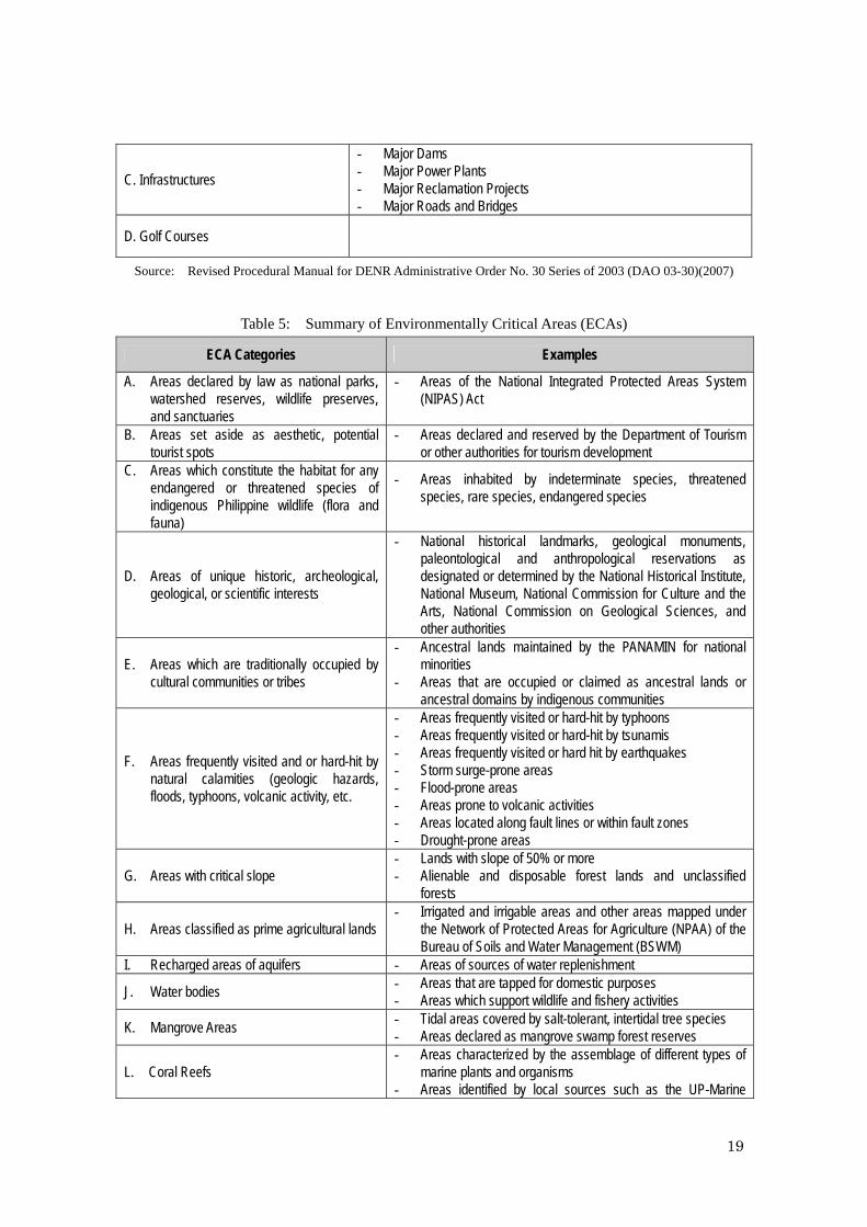
7.1.4 Covered Projects of PEISS Projects which have been originally declared as Environmentally Critical Projects (ECPs) or projects in Environmentally Critical Areas (ECAs) presumed to have significant impacts on the quality of the environment, and to be subjects of PEISS. The four (4) ECP project types and twelve (12) ECA categories have been declared through Proclamation No. 2146 (1981) and Proclamation No. 803 (1996), as shown in Table 4 and Table 5.
Table 4: Summary of Environmentally Critical Projects (ECPs)
Main Category Sub-Category
A. Heavy Industries
- Non-Ferrous Metal Industries - Iron and Steel Mills - Petroleum and Petrochemical Industries - Smelting Plants
B. Resource Extractive Industries - Major Mining and Quarrying Projects - Forestry Projects - Dikes for/and Fishpond Development Projects
18
C. Infrastructures
- Major Dams - Major Power Plants - Major Reclamation Projects - Major Roads and Bridges
D. Golf Courses
Source: Revised Procedural Manual for DENR Administrative Order No. 30 Series of 2003 (DAO 03-30)(2007)
Table 5: Summary of Environmentally Critical Areas (ECAs)
ECA Categories Examples
A. Areas declared by law as national parks, watershed reserves, wildlife preserves, and sanctuaries
- Areas of the National Integrated Protected Areas System (NIPAS) Act
B. Areas set aside as aesthetic, potential
tourist spots - Areas declared and reserved by the Department of Tourism
or other authorities for tourism development C. Areas which constitute the habitat for any
endangered or threatened species of indigenous Philippine wildlife (flora and fauna)
- Areas inhabited by indeterminate species, threatened species, rare species, endangered species
D. Areas of unique historic, archeological, geological, or scientific interests
- National historical landmarks, geological monuments, paleontological and anthropological reservations as designated or determined by the National Historical Institute, National Museum, National Commission for Culture and the Arts, National Commission on Geological Sciences, and other authorities
E. Areas which are traditionally occupied by cultural communities or tribes
- Ancestral lands maintained by the PANAMIN for national minorities
- Areas that are occupied or claimed as ancestral lands or ancestral domains by indigenous communities
F. Areas frequently visited and or hard-hit by natural calamities (geologic hazards, floods, typhoons, volcanic activity, etc.
- Areas frequently visited or hard-hit by typhoons - Areas frequently visited or hard-hit by tsunamis - Areas frequently visited or hard hit by earthquakes - Storm surge-prone areas - Flood-prone areas - Areas prone to volcanic activities - Areas located along fault lines or within fault zones - Drought-prone areas
G. Areas with critical slope - Lands with slope of 50% or more - Alienable and disposable forest lands and unclassified
forests
H. Areas classified as prime agricultural lands - Irrigated and irrigable areas and other areas mapped under
the Network of Protected Areas for Agriculture (NPAA) of the Bureau of Soils and Water Management (BSWM)
I. Recharged areas of aquifers - Areas of sources of water replenishment
J. Water bodies - Areas that are tapped for domestic purposes - Areas which support wildlife and fishery activities
K. Mangrove Areas - Tidal areas covered by salt-tolerant, intertidal tree species - Areas declared as mangrove swamp forest reserves
L. Coral Reefs - Areas characterized by the assemblage of different types of
marine plants and organisms - Areas identified by local sources such as the UP-Marine
19
Sciences Institute, DENR-Coastal Environment Program to be rich in corals.
Source: Revised Procedural Manual for DENR Administrative Order No. 30 Series of 2003 (DAO 03-30)(2007)
To help identifying required documents under PEISS for consultation and decision making by EMB - DENR, projects are classified into five major groups as described in Table 6.
Table 6: Project Groups for EIA under PEISS
Group I
ECPs in either ECAs or NECAs (Environmentally Critical Projects in either Environmentally Critical
Areas or Non-Environmentally Critical Areas)
Group II NECPs in ECAs (Non-Environmentally Critical Projects in Environmentally Critical Areas)
Group III NECPs in NECAs (Non-Environmentally Critical Projects in Non-Environmentally Critical Areas)
Group IV Co-located Projects in either ECA or NECA
Group V Unclassified Projects
Source: Revised Procedural Manual for DENR Administrative Order No. 30 Series of 2003 (DAO 03-30)(2007)
EIA-covered projects in Groups I, II and IV are required either of follows depending on project type, location, magnitude of potential impacts and project threshold. For non-covered projects in Groups II and III, the PDR is required. (1) Environmental Impact Statement (EIS), (2) Programmatic EIS (PEIS), (3) Initial Environmental Examination Report (IEER), or (4) IEE Checklist (IEEC). (5) Project Description Report (PDR). All documents should be prepared by the project proponent to be submitted to the EMB Central Office or the Environmental Impact Assessment Division in respective EMB Regional Office. The outcome of the EIA Process within PEISS administered by the EMB-DENR is the issuance of decision documents. Decision documents may either be an ECC, CNC or a Denial Letter, described as follows. The PDR is especially important for Group II and Group III to secure eventual issuance of a Certificate of Non-Coverage (CNC). (1) An ECC is issued as a certificate of Environmental Compliance Commitment to
which the Proponent conforms with, after DENR-EMB explains the ECC conditions.
20
(2) A Certificate of Non-Coverage (CNC) certifies that, based on the submitted Project Description Report, the project is not covered by the EIS System and is not required to secure an ECC.
(3) A Denial Letter shall contain an explanation for the disapproval of the application and guidance on how the application can be improved to a level of acceptability in the next EIA process.
For Group I projects, ECC application documents need to be submitted to EMB central office to have decisions by EMB Director or DENR Secretary. While, ECC application for Group II need to be submitted to EMB Regional Office to have decision making by the EMB Regional Director. Table 7 summarizes Project Groups, EIA Report Types, Decision Documents, Deciding Authorities and Processing Duration described in the Revised Procedural Manual of EMB.
Source: Revised Procedural Manual for DENR Administrative Order No. 30 Series of 2003 (DAO 03-30) (2007)
21
7.1.5 Outlines of Required Documents As previously discussed, for the projects which will be indicated in SEDP, depending on project type, location, magnitude of potential impacts and project threshold, either EIS, IEER or PDR will be required. Followings are outlines of the required documents from Revised Procedural Manual for DENR Administrative Order No. 30 Series of 2003.
(1) EIS Outline (Maximum of about 250 pages)
Project Fact Sheet Table of Contents Executive Summary 1) Brief Project Description 2) Brief Summary of Project’s EIA Process 3) Summary of Baseline Characterization 4) Summary of Impact Assessment and Environmental Management Plan 5) Summary of Environmental Monitoring Plan 6) EMF and EGF Commitments DRAFT MAIN EIS 1. BASIC PROJECT INFORMATION 2. DESCRIPTION OF THE PROJECT’S EIA PROCESS 2.1. Terms of Reference of the EIA Study 2.2. EIA Team 2.3. EIA Study Schedule 2.4. EIA Study Area 2.5. EIA Methodology 2.6. Public Participation 3. PROJECT DESCRIPTION 3.1. Project Location and Area 3.2. Project Rationale 3.3. Project Alternatives 3.4. Project Development Plan, Process/Technology Options and Project Components 3.5. Description of Project Phases (Activities/Environmental Aspects, Associated Wastes and Built-in Pollution Control Measures) 3.5.1. Pre-construction/ Pre-operational phase 3.5.2. Construction/Development phase 3.5.3. Operational phase 3.5.4. Abandonment phase 3.6. Manpower Requirements 3.7. Project Cost 3.8. Project Duration and Schedule 4. BASELINE ENVIRONMENTAL CONDITIONS, IMPACT ASSESSMENT AND MITIGATION 4.1. The Land (Discuss only relevant modules) 4.1.1. Land Use and Classification 4.1.2. Pedology 4.1.3. Geology and Geomorphology 4.1.4. Terrestrial Biology 4.2. The Water (Discuss only relevant modules) 4.2.1. Hydrology & Hydrogeology 4.2.2. Oceanography 4.2.3. Water Quality
22
4.2.4. Freshwater Biology 4.2.5. Marine Biology 4.3. The Air (Discuss only relevant modules) 4.3.1. Meteorology 4.3.2. Air Quality and Noise 4.4. The People 5. ENVIRONMENTAL RISK ASSESSMENT (WHEN APPLICABLE) 6. ENVIRONMENTAL MANAGEMENT PLAN 6.1. Impacts Management Plan 6.2. Social Development Framework 6.3. IEC Framework 6.4. Emergency Response Policy and Generic Guidelines 6.5. Abandonment /Decommissioning /Rehabilitation Policies and Generic Guidelines 6.6. Environmental Monitoring Plan 6.6.1. Self-Monitoring Plan 6.6.1. Multi-sectoral Monitoring Framework 6.6.1. Environmental Guarantee and Monitoring Fund Commitment 6.7. Institutional Plan for EMP Implementation 7. BIBLIOGRAPHY/REFERENCES 8. ANNEXES 8.1. Scoping Checklist 8.2. Original Sworn Accountability Statement of Proponent 8.3. Original Sworn Accountability Statement of Key EIS Consultants 8.4. Proof of Public Participation 8.5. Baseline Study Support Information 8.6. Impact Assessment and EMP Support Information
Source: Revised Procedural Manual for DENR Administrative Order No. 30 Series of 2003 (DAO 03-30)(2007)
(2) IEER Outline (Maximum of about 75 pages)
Project Fact Sheet Table of Contents Executive Summary 1) Brief Project Description 2) Brief Summary of Project’s IEE Process 3) Summary of Baseline Characterization 4) Summary of Impact Assessment and Environmental Management Plan 5) Summary of Environmental Monitoring Plan DRAFT MAIN IEER 1. BASIC PROJECT INFORMATION 2. DESCRIPTION OF THE PROJECT’S IEE PROCESS - 2.1. Terms of Reference of the IEE Study (if scoping was done with EMB) 2.2. IEE Team 2.3. IEE Study Schedule 2.4. IEE Study Area 2.5. IEE Methodology 3. PROJECT DESCRIPTION 3.1. Project Location, Area, ECA category (if applicable) 3.2. Project Rationale 3.3. Project Development Plan, Process/Technology and Project Components 3.4. Description of Project Phases (Activities/Environmental Aspects, Associated Wastes and Built-in Pollution Control Measures) 3.4.1. Pre-construction/ Pre-operational phase 3.4.2. Construction/Development phase
23
3.4.3. Operational phase 3.4.4. Abandonment phase 3.5. Manpower Requirements 3.6. Project Cost 3.7. Project Duration and Schedule 4. BASELINE ENVIRONMENTAL CONDITIONS, IMPACT ASSESSMENT AND MITIGATION 4.1. The Land (Discuss only relevant modules or modules likely to be affected by project impacts) - Land use, Pedology, Geology, Geomorphology, Terrestrial biology 4.2. The Water (Discuss only relevant modules or modules likely to be affected by project impacts – Hydrology, Oceanography, Water Quality, Freshwater Biology, Marine Biology 4.3. The Air - ((Discuss only relevant modules or modules likely to be affected by project impacts - Meteorology, Air Quality, Noise 4.4. The People 5. ENVIRONMENTAL MANAGEMENT PLAN 5.1. Impacts Management Plan 5.2. Emergency Response Policy and Generic Guidelines (if applicable) 5.3. Environmental Monitoring Plan 5.4. Institutional Plan for EMP Implementation 6. BIBLIOGRAPHY/REFERENCES 7. ANNEXES 7.1. Scoping Checklist (optional, since Scoping is not required for IEEs) 7.2. Original Sworn Accountability Statement of Proponent 7.3. Original Sworn Accountability Statement of IEE Preparer 7.4. Baseline Study Support Information
Source: Revised Procedural Manual for DENR Administrative Order No. 30 Series of 2003 (DAO 03-30)(2007)
(3) PDR Outline (maximum of about 30 pages)
Table of Contents (1 page) 1. BASIC INFORMATION ON PROJECT and PROPONENT (1 page) 2. PROJECT DESCRIPTION (15 pages) 2.1. Project Location and Area (at the minimum, shown in an official NAMRIA topographic or nautical map (whichever type is applicable and of appropriate scale) 2.2. Project Rationale (need for & purpose of the project., particularly environmental enhancement or mitigation purpose of the project) 2.3. Project Development Plan, Process and Components 2.4. Description of Project Phases 2.4.1. Pre-Construction/ Pre-Development phase 2.4.2. Construction/Development phase 2.4.3. Operational phase 2.4.4. Abandonment phase 2.5. Project Emissions/Effluent/ Hazardous Waste/Solid Waste/Other Wastes (Present integrated summary of types of wastes) 2.7. Project Cost 2.8. Project Duration and Schedule 3. OVERVIEW/GENERIC DESCRIPTION OF THE BASELINE ENVIRONMENT (4 pages – on land, water, air, people) 4. ENVIRONMENTAL MANAGEMENT PLAN (3 pages - focused only on the residual management scheme on the relevant land, water air & people module) 5. ANNEXES (3-6 pages) 5.1 Original Sworn Accountability Statement of Proponent 5.2 Photos or plates of proposed project site, cumulative/residual impact areas and surrounding communities
24
Source: Revised Procedural Manual for DENR Administrative Order No. 30 Series of 2003 (DAO 03-30)(2007)
7.2 Other Environmental Laws and Regulations Concerning the Project Followings are major environmental laws and regulations, which may concern the Project. For the implementation of all projects in SEDP, PEISS states obligations to strictly comply with the environmental laws, regulations and standards, which were established by GRP. When project type, location, scale, and magnitude of potential impacts are clarified, all concerning laws and regulation should be identified to examine the requirements.
(1) Environment Code, Presidential Decree No. 1152 Known as the Philippine Environment Code, it launches a comprehensive program on environmental protection and management. It also provides for air, water quality, land use, natural resources and waste management for fisheries and aquatic resources; wildlife; forestry and soil conservation; flood control and natural calamities; energy development; conservation and utilization of surface and ground water and mineral resources.
(2) Water Code, Presidential Decree No. 1067 A decree instituting a water code which revises and consolidates the laws governing the ownership, appropriation, utilization, exploitation, development, conservation and protection of water resources. (3) Clean Water Act, Republic Act 9275 An Act which aims to protect the country’s water bodies from pollution of all possible sources (industrial, commercial, agriculture and household activities). It provides for a comprehensive and integrated strategy to prevent and minimize pollution through a multi-sectoral and participatory approach involving all the stakeholders.
(4) Clean Air Act of 1999, Republic Act No. 8749 An Act which lays down policies to prevent and control air pollution. The act sets standards of exhaust gas from vehicles, manufacturing plants and so on to follow. All potential source of air pollution must comply with the provisions of the Act. As such, all emissions must be with in the air quality standards set under the law. It also imposes the appropriate punishments for violators of the law.
An Act providing for an ecological solid waste management program, creating the necessary institutional mechanisms and incentives, declaring certain acts prohibited and providing penalties, appropriating funds therefore, and for other purposes.
(6) Pollution Control Law, Presidential Decree No. 984 An Act that serves as the foundation for managing industrial activities impacting air and water quality. It empowers the DENR to impose ex-parte cease and desist orders (CDO) on the grounds of immediate threat to life, public health, safety or welfare, or to animal or plant life when wastes or discharges exceed the normal.
(7) Forestry Reform Code, Presidential Decree No. 705 The Forestry Reform Code of the Philippines recognizes that there is an urgent need for proper classification; management and utilization of the lands of the public domain to maximize their productivity to meet the demands of the increasing population of the Philippines. It surmises that to achieve the above purpose, it is necessary to reassess the multiple uses of forest lands and resources before allowing any utilization to optimize the benefits that can be derived. It also emphasizes not only the utilization but more so on the protection, rehabilitation and development of forest lands to ensure the continuity of their productive condition.
(8) National Integrated Protected Areas System (NIPAS), Republic Act No. 7586 An Act that aims to protect and maintain the natural biological and physical diversities of the environment notably on areas with biologically unique features to sustain human life and development as well as plant and animal life. It establishes a comprehensive system of integrated protected areas within the classification of national park as provided for in the Constitution to secure for the Filipino people of present and future generations the perpetual existence of all native plants and animals. It encompasses outstandingly remarkable areas and biologically important public lands that are habitants of rare and endangered species of plants and animals, bio-geographic zones and related ecosystems, whether terrestrial, wetland or marine.
7.3 Social Development Laws and Regulations Concerning the Project
(1) Indigenous Peoples Rights Act (IPRA), Republic Act No. 8371 (1997) The IPRA enforces the Constitution’s mandate for the State to “recognize and promote the right of indigenous peoples within the framework of national unity and development,” and “protect the right of indigenous cultural communities to their
26
ancestral lands to ensure their economic, social and cultural well-being.” These include the right to ancestral domain and lands; right to self-governance and empowerment; social justice and human rights; and the right to cultural integrity.
8 Provisional Scoping 8.1 Prospective Sectors and Projects As discussed previously, the SEDP can be divided into three major components, namely 1) Action Plan, 2) Short Term Development Plan and 3) Medium Term Development Plan. All plans are designed to associate with development visions, goals and strategies as well as potential project options. The Short Term Development Plan and the Medium Term Development Plan are mainly Policy-Plan level frameworks, which aim socio-economic development based on the results of reconstruction and rehabilitation projects in the Action Plan. So far, the Study Team tentatively identified priority sectors and projects only for the Action Plan, which list is indicated in Table 8, and provisional scoping here is conducted based on the list. Environmental and social impacts of other project options in SEDP should be assessed when draft SEDP is prepared.
Although, the scale and location are not identified, most projects indicated in Table 8 seems to be basic living infrastructure projects, which are planned to be small and local in accordance with the scope, time, and financial restriction of the Action Plan.
In Table 8, "○" indicates very small infrastructure or facility, which might not have serious impacts, and "◎" indicates small-medium scale infrastructure or facility, which might have impacts in some extents. No mark means that corresponding projects do not contain infrastructure or facility development, and are not subjects of EIA.
Table 8: Prospected Sectors and Projects
Sectors Development Needs Infrastructure Projects
Road (barangay Road, Farm to Market Road) ◎
Bridge (Box culvert, Hanging bridge) ○ 1. Transportation Transportation (Pumpboat, Bus) Water System (Spring Improvement, Hand Pump) ○
Electrification (Solar Power, Generator) ○
Public Toilet ○
Housing ○
2. Basic Living Condition
Waste Management (Garbage Disposal) ○
School Building (New Construction, Renovation) ○
Madrasah (New Construction, Renovation, Additional) ○
Day Care Center ○
3. Education
Educational Support (Scholarship)
27
School Dormitory ○
School Facility Health Center ○
Medical & Health Care Facilities & Services Barangay Pharmacy
4. Health
Birthing Clinic ○
Farming Facilities/Equipment 5. Agriculture Irrigation /Controlled Dam ◎
Livelihood (Live stocks, Poultry) 6. Community Empowerment Capacity Building (Literacy Program, Training) Multi-Purpose Center (New Construction, Renovation) ○
Sports Facilities(Basketball Court/Gymnasium) ○
barangay Plaza ○ 7. Culture/Sports
Garden Facilities Drainage (Flood Control) ○ 8. Water Control Dike (Lake wall, River wall) ◎
Construction Facility ○ : very small infrastructure or facility, which might not have serious impacts. ◎ : small – medium scale infrastructure or facility, which might have impacts in some extents. No mark: means that corresponding projects do not contain infrastructure or facility development..
Source:JICA Study Team
8.2 Provisional Scoping Table Table 9 is a Provisional Scoping Table, which indicates the check items and its prospective impacts for the proposed projects described in Table 8. The review of possible adverse impacts is derived based on literature survey, key informant interviews, and field observation on QIP Phase 1 sites.
28
Table 9: Provisional Scoping
Tran
spor
tation
Basic
Livin
g Con
dition
Educ
ation
Healt
h
Agric
ultur
e
Comm
unity
Emp
ower
ment
Cultu
re/S
ports
Wate
r Con
trol
Fishe
ries
Busin
ess/T
ouris
m
Secu
rity/ E
merg
ency
Relig
ious
Othe
rs
1 Involuntary Resettlement C C C C C
2 Local economy such as employment and livelihood B B C B B C
3 Land use and utilization of local resources. C C C C C C
4 Social institutions such as social infrastructure and localdecision making institutions. C C C C C
5 Existing local infrastructures and services C C C C C C C C C C C
6 The poor, indigenous and ethnic groups C C C C C C C C C C C
7 Mis-distribution of benefits and damages C C C C C C C C C B C
8 Cultural heritage/ Local landscape
9 Local conflicts of interest C C C C C C B C C C C
10 Water usage or water right and rights of commons B B
11 Sanitation C C C C C C C
12 Hazards, infectious diseases C C C C C C C
13 Topography and geographical features B C C C C
14 Soil erosion C C C C C
15 Ground water C C C
16 Hydrogical situation C C
17 Coastal zone C
18 Ecosystems/ Wildlife/ Biodiversity C C C C
19 Protected Area C
20 Land scapes C C
21 Air pollution/ Global warming gas C
22 Water pollution C C C C
23 Soil contamination
24 Waste C C C C C
25 Noise & Vibration C C
26 Ground subsidence
27 Offensive odor
28 Bottom sediment C
29 Accidents C
Pollu
tions
& P
ublic
Haz
ards
Check Items
Sectors
Socia
l Env
ironm
ent
Natur
al En
viron
ment
C
A: Serious impact is expected. B: Some Impacts /Unknown impacts are expected. C: Extent of impact is unknown.(Examination is needed. Impacts may become clear as study progresses.) No mark: No impact is expected. EIA is not necessary.
Source:JICA Study Team
29
8.3 Types and Magnitudes of Possible Adverse Impacts and Mitigation Procedures 8.3.1 Impacts of Exiting Similar Small Infrastructures According to the key informant interviews to BDA staff and the inhabitants of selected barangays for QIP Phase 1, no major problems and conflicts were reported in the earlier small scale infrastructure development projects. However, conflict generating mechanism varies greatly depending on the natural conditions, socio-economic characteristics, historical grudge and so on. When the scale and the location of projects are identified, appropriate environmental and social impact assessment should be conducted.
8.3.2 Key Impacts Identified in Provisional Scoping and the Mitigation At this stage of the Study, environment and social impact assessment can be conducted
by means of existing information, data and interviews to the study team members.
Table 10: Key Impacts Identified in Provisional Scoping
Description of Key Impacts
Involuntary ResettlementInvoluntary resettlement is not likely to occur if the scales of infrastructure are small. However, medium scaleland acquisition associated with displacement of existing infrastructure may induce resettlement of housingsor commercial settlements.
Local economy such as employment andlivelihood
Improvement of transportation system can promote local economy, and may provide job opportunity to localcommunities.
Land use and utilization of local resources. Economical development of CAAMs may induce better utilization of local natural and human resources.
Social institutions such as social infrastructureand local decision making institutions.
Land acquisition associated with construction of new infrastructure or displacement of existing infrastructuremay affect social institutions. However, impact is expected to be not significant.
Existing local infrastructures and services Land acquisition associated with construction of new infrastructure or displacement of existing infrastructuremay affect existing local infrastructures and services. However, impact is expected to be not significant.
The poor, indigenous and ethnic groups
Conducted under the supervision of BDA, significant negative impact on Muslim community is not expected.However, negative impact on other religious groups or ethnic groups may occur. When the site is proposed,need to verify the impacts with the communies. Physical separation is not expected. During the constructionstage, if outsiders coming for the civil works may affect local public morals. The construction may forcewomen and children to work on river basin for sand and gravel extraction.
Mis-distribution of benefits and damages
Conducted under the supervision of BDA, significant negative impact on Muslim community is not expected.However, negative impact on other religious groups or ethnic groups may occur. It is not expected to createany land use restriction. However, when the site is proposed, need to verify the impacts with community.Improvement of transportation system mayl ease the transportation of products of the CAAMs.
Local conflicts of interestConducted under the supervision of BDA, significant negative impact on Muslim community is not expected.However, negative impact on other religious groups or ethnic groups may occur. When the site is proposed,need to verify the impacts with the communies.
Ecosystems/ Wildlife/ Biodiversity No significant impact is expected, since the projects are small and local. However, with reference to theGuidelines for PEISS, consultation with EMB is required, when the site is proposed.
Protected Area No significant impact is expected, since the projects are small and local. However, with reference to theGuidelines for PEISS, consultation with EMB is required, when the site is proposed.
Natur
al En
viron
ment
Check Items
Socia
l Env
ironm
ent
Source:JICA Study Team
30
(1) Social Environment 1) Involuntary Resettlement Involuntary resettlement is not expected for SEDP since the scales of projects are small and confined. However, it is important to regard highly the fact that claim on land has been a major issue of conflicts in CAAMs historically, and therefore; special attention is required. The major complexity of land tenure issue is generated by the situation that the laws and regulations enforced by GRP, which were historically promoted with the migration of Christians, and traditional practice of land management by the Mindanao Muslim society, that land are managed socially and politically in ‘sultanates’, exist side by side. Therefore, it is obligatory to conduct screening of land tenure from the different sides of view when the project design become more concrete and the location and the scale become more apparent. Utilizing the advantage of ongoing efforts to clarify land claims may help to avoid conflicts. Currently, there are several land tenure improvement programs, which identify land ownership and facilitate the generation of land titles, be undertaken by the regional government. For the implementation of QIP Phase 1, lands were donated by the owners through the coordination of BDA, and consequently no conflict is reported. For the implementation of projects, maximum effort to avoid conflicts should be made. 2) The Poor, Indigenous and Ethnic Groups Considering the fact that socially disadvantaged groups, such as women, elderly, the poor, ethnic minorities are susceptible to various social and environmental impacts, proper attention should be paid to them. Since they have weak access to the decision-making process, the project should encourage their participation for the stakeholder meeting especially in project selection and formulation stages.
3) Mis-Distribution of Benefits and Damages Statistically, most of the Muslim population in Philippines is inhabited in CAAMs. However, significant number of other religious and ethnic groups, such as Christians and indigenous minorities, reside along with them. Fair and objectively established criteria should be applied to the project selection. Information disclosures, public hearing and consultation with stakeholders from different religious and ethnic groups should be promoted with considering historical aspects of land claims, migration, and conflicts.
31
(2) Natural Environment 1) Ecosystems/ Wildlife/ Biodiversity The SEDP is planned to have mainly small scale infrastructures or rehabilitation of existing structures, therefore; significant impact on the natural environment is not expected. As discussed previously, PEISS states "Areas which constitute the habitat for any endangered or threatened species of indigenous Philippine wildlife (flora and fauna)" as ECA for EIA implementation. The designation as ECA is decided by the EMB Regional Office based on individual consultation for particular projects, so when target area is identified, communications with the EMB is requisite. Especially in CAAMs, because of the conflict affected environment, law enforcement and policy related efforts for ecosystem, wildlife and biodiversity conservation by GRP may not be adequate, and related information may be limited. To confirm that indeterminate species, threatened species, rare species and endangered species are not inhabited in the prospective project areas, ecological survey is recommended in feasibility study stage of individual project. In case rare plants or animals are exposed by the ecological survey as a part of EIA study, appropriate consultations with the relevant agencies, such as EMB, LGU and BDA, should be conducted to ascertain measures to be taken by each agency. 2) Protected Area PEISS states "Areas declared by law as national parks, watershed reserves, wildlife preserves, and sanctuaries" as ECA, so that all areas of the National Integrated Protected Areas System (NIPAS) should be excluded from prospective project areas. In addition to the exiting protected areas, the "List Proposed Protected Areas" and "Key Biodiversity Areas" should be examined in consultation with the Regional Office of Protected Areas and Wildlife Bureau (PAWB), when the project target area and the scale are identified. One of the most critical areas of sensitive ecosystem, which may directly be affected by the project, is the Liguasan marsh, which is considered the largest wetland in the Mindanao. The area covers approximately 288,000 hectares over the provinces of Maguindanao, Cotabato and Sultan Kudarat.
3) Landscapes Among the potential projects discussed in Table 8, projects which need special attention to examine the possibility of landscape alternation are developments of road network (barangay road, farm to market road), flood control facilities and irrigation system. The improvement of channel and construction of dikes and reservoirs for
32
agricultural use as well as flood control and mitigation may require alternation of landscape. Physical infrastructure constructions, such as housing, port, boulevard, and public market building also need special attentions. At this moment, it is impossible to asses the potential impact since the basic design, location and scale are not identified. In the stage of feasibility study, all prospected impact should be assessed.
9 Alternatives to the Project Activities
9.1 Options for Alternative Analysis in Different Development Plan Level The Projects, for which in particular potential negative impacts on environmental and social aspects can be foreseen, should be considered along with alternatives to mitigate or to avoid those impacts. As described previously, SEDP is planned to contain different levels of proposals in from policy level to project level. In terms of the level, appropriate alternative analysis will be required when draft SEDP will be formulated. Table 11 indicates the example of alternative analysis for development plan.
Table 11: Required Alternative Analysis for Development Study (example)
Level of Development Plan and Required Alternatives (example) Policy Plan Program Project
- Comprehensive
development scenarios - Comprehensive
Strategic alternatives
- Development scenarios - Strategic
alternatives - Land use
alternatives - Priority sector
alternatives
- Program alternatives - Priority program
alternatives
- Location, route alternatives - Technical
application alternatives - Implementation
alternatives
1. SEDP Action Plan ○ ◎
2. SEDP Short Term Plan ○ ◎ ○ ○
3. SEDP Medium Term Plan ○ ◎ ○ ○
Source:JICA Study Team
Especially, ECPs or projects located ECAs are envisaged to have adverse impact on the environment, and subjects of EIA on PEISS, therefore, environmental and social impacts need to be assessed in project basis along with the alternative analysis. 9.2 “Without Project” Option At present, SEDP is under development, and the only option can be assessed here is "without project" option.
33
(1) Without Project Option (other projects will be implemented without SEDP) No project for reconstruction and rehabilitation of basic living infrastructure based on the barangay level needs assessment will be implemented. As for the negative impact, communities excluded from existing projects will remain with poor conditions in basic living infrastructure, which may induce further poverty and worse living conditions. Economic development potential of CAAMs remains very limited, since the road network and market facilities remain in poor conditions. There will be no development plan formulated by the positive participation of BDA and Muslim people, and socio-economic reconstruction efforts of GRP based on the development plan formulated mainly by Christian people, may spoil the cooperation and support of Muslim people. The effort of GRP remains with risk of excluding Muslim people and other minority groups for benefit distribution. Japan's assistance for reconstruction and rehabilitation of CAAMs will be restricted with only existing development plan of GRP. (2) With Project Option (other projects will be implemented along with SEDP) As for the positive impact, the implementation of SEDP based on the community level needs assessment may cover all barangays which require urgent assistance. Road network and market facilities will be enhanced, and the development potential especially for agricultural industry will hike. The SEDP is considered as the only development plan formulated through the initiative of BDA and Muslim people, and it may induce positive cooperation of BDA/MILF and Muslim people. SEDP along with the existing development plan may generate synergy impact. The SEDP assures the commitment of Japan's cooperation for socioeconomic reconstruction of CAAMs. Under the cooperation of Japanese government, environmentally conscious plan will be formulated and negative impact on social and natural environment will be avoided, minimized or mitigated. As for the negative impact, for the project and the location selection, groups other than Muslims may be excluded, and the benefit will be distributed unequally. Non-Muslim people may have frustration because of too much attention on Muslims. Intensive development initiatives by Muslim people may create discrimination on non-Muslim people.
10 Results of the Discussion with Recipient Government 10.1 Project Presentation to the Recipient Government, BDA and other Stakeholders The Study Team visited EMB Regional Office X, XI, XII, and ARMM, as well as BDA, and explained the project background, project objectives, outlines and JICA's commitment on environmental and social considerations, which is described in JICA Guidelines for
34
Environmental and Social Considerations. All concerned division assured to provide necessary cooperation and support for the Study. Also, the Study Team had several meetings with BDA to assure the commitment on environmental and social considerations. In the workshop held in Cotabato, the Study Team presented the outline of JICA's Guidelines, and pledged commitment of environmentally and socially conscious way of SEDP development.
10.2 Requirement of PEISS on QIPs and OSAs Based on the discussion with EMB Regional Office XII, it is confirmed that QIP and OSA are not significant scale and may not be subjects of EIA under PEISS. However, Project Description Report (PDR) need to be prepared for each project, and submitted to the EMB Regional Office of respective region to secure issuance of a Certificate of Non-Coverage (CNC). 10.3 Requirement of PEISS on SEDP According to the EMB Regional Office XII, as SEDP is a development plan which implementation is indeterminate, there is no requirement by PEISS at the formulation stage. However, Environmental Impact Statement (EIS) should be prepared during feasibility study (FS) stage and initial environmental assessment should be conducted during pre-feasibility study stage. EIA need to be undertaken before commencement of the project, and required documents should be prepared either project proponent or their designated consultants.