+ All Categories
Home > Documents > THE SUB-KALAHARI GEOLOGY AND TECTONIC EVOLUTION …

THE SUB-KALAHARI GEOLOGY AND TECTONIC EVOLUTION …

Date post: 11-Nov-2021
Category:
Upload: others
View: 3 times
Download: 0 times
Share this document with a friend
360
THE SUB-KALAHARI GEOLOGY AND TECTONIC EVOLUTION OF THE KALAHARI BASIN, SOUTHERN AFRICA. by Ian Gerald Haddon A thesis submitted to the Faculty of Science, University of the Witwatersrand, Johannesburg, in fulfilment of the requirements for the degree of Doctor of Philosophy. Johannesburg, 2005
Transcript

THE SUB-KALAHARI GEOLOGY AND TECTONIC EVOLUTION OF

THE KALAHARI BASIN, SOUTHERN AFRICA.

by

Ian Gerald Haddon

A thesis submitted to the Faculty of Science, University of the Witwatersrand, Johannesburg, in

fulfilment of the requirements for the degree of Doctor of Philosophy.

Johannesburg, 2005

ACKNOWLEDGEMENTS The preparation of this thesis has involved the assistance of many people and my sincere thanks to all those who have helped with my research in any way. In particular, certain people need to be mentioned by name: Eddie Van Wyk and other staff at the Department of Water Affairs and Forestry as well as the staff at Sishen Iron Ore, Wessels Manganese and Black Rock Manganese Mines were of great help in providing much of the borehole data for South Africa. The staff at the Geological Survey Departments of Angola, Namibia, Zambia, Zimbabwe and Botswana are also thanked for their co-operation in providing data for the compilation of the isopach and geological maps. South African National Parks are thanked for allowing me access to Kalahari Group outcrops in the Kalahari Gemsbok Park. Mike de Wit and John Ward of De Beers provided valuable feedback on the palaeo-drainage reconstructions of the region as well as the stratigraphy of the northern parts of the Kalahari Basin. At the Council for Geoscience Greg Botha is thanked for his guidance during the early stages of this project. Barry Millsteed, Mike Johnson, Gerrit de Kock and Matt Du Toit provided excellent advice and scientific input and Nols Van Vuuren and Peter Zawada provided continuous support and encouragement for the project. Marcel Brits and Kryzia Guszek helped with the digitising of some of the base maps used for the compilations. Doreen Van der Walt spent endless patient hours teaching me how to use ArcInfo and helping me produce the GIS-generated maps. The director of the Council for Geoscience is thanked for the opportunity to do this research and for permitting the work conducted on the Kalahari Basin to be used for a thesis. My thesis supervisor Prof. Spike McCarthy provided invaluable criticism and insight and continually challenged me to re-examine preconceived and outdated ideas about the Kalahari Basin. Lastly, thanks to my parents and Julia for all of their support and encouragement.

-i-

ABSTRACT

Geophysical, borehole and mapped data from the Kalahari Basin were used to create maps of the

sub-Kalahari geology, isopachs of the Kalahari Group and basal gravels and a sub-Kalahari

topographical surface. These are the first basin-wide maps of this type to be produced. These new

data were interpreted with the aid of an extensive literature review as well as data gathered at

three localities in the southern part of the Kalahari Basin and enabled several conclusions to be

made regarding the tectonic evolution of the area.

The sub-Kalahari Geological Map shows that rocks dating from the Archaean to present are

exposed on the edges of the basin as well as covered by the Kalahari Group sedimentary rocks.

Many of the rocks shown on the sub-Kalahari geological map record a history of rifting and

subsequent collision, with the NE and SW trending structures appearing to have been reactivated

at various times in the geological past. The extent of Karoo Supergroup rocks is greater than

previously thought and Karoo sedimentary and volcanic rocks cover a large percentage of the

sub-Kalahari surface. The Karoo Supergroup lithologies have been intruded by dolerite dykes and

sills and the massive Botswana Dyke Swarm is shown on the sub-Kalahari map extending in a

northwest direction across Botswana.

The subtraction of the thicknesses of Kalahari Group sediments from the current topographical

digital elevation model (DEM) of Africa in order to prepare a DEM of the sub-Kalahari

topographical surface and the preparation of an isopach map of the basal gravels gives some

indication of the courses followed by Mid-Cretaceous rivers. Topographic profiles along the

proposed courses of these rivers show that the floor of the Kalahari Basin has a particularly low

elevation in certain areas suggesting that downwarp of the interior of the basin rather than

adjacent uplift was the driving force behind Kalahari Group sedimentation. When down-warp

of the Kalahari Basin began in the Late Cretaceous these rivers were back-tilted into the newly

formed basin and deposition of the Kalahari Group sediments began. The basal unit of the

Kalahari Group consists of gravels deposited by the Cretaceous rivers as well as on scree slopes.

As down-warp of the basin continued, so more gravels were deposited as well as the sand and

-ii-

finer sediment carried by the rivers. Thick clay beds accumulated in the lakes that formed by the

back-tilted rivers, with sandstone being deposited in braided streams interfingering with the clays

and covering them in some areas as the shallow lakes filled up with sediment.

During the Mid-Miocene there was a period of tectonic stability that saw the silcretisation and

calcretisation of older Kalahari Group lithologies. At the end of the Miocene there was some

uplift along the eastern side of southern Africa as well as along certain epeirogenic axes in the

interior. In general this uplift was fairly gentle. Later more significant uplift in the Pliocene

possibly elevated Kalahari Group and Karoo Supergroup sedimentary rocks above the basin floor

and exposed many of them to erosion. The eroded sand was washed into the basin and reworked

into dunes during drier periods. This uplift occurred along epeirogenic axes and was greater than

the Miocene uplift.

The development of the East African Rift System (EARS) in the Late Eocene or Oligocene has

had a significant influence on the Kalahari Basin. Reactivation of older NE-SW trends by SW-

propagating rifts extending from the main EARS is evident by recent movement along faults

along the Damara Belt and those that were associated with Karoo sedimentation and post-Karoo

graben formation. The propagating rifts have resulted in uplifting, faulting and in some cases,

graben formation. In some cases lakes have formed in the grabens or half-grabens themselves and

in other cases they have been formed between the uplifted arches related to parallel rifts. The

propagating rifts have had a strong influence on the drainage patterns and shape of the Kalahari

Basin, in particular in the middle parts of the basin where they have controlled the formation of

the Okavango Delta and the Makgadikgadi pans.

LIST OF FIGURES

Chapter 1: Introduction

Fig. 1.1 Locality map of the Kalahari BasinFig. 1.2 Main roads, railway lines and towns in the Kalahari Basin.

Chapter 2: Methodology

Chapter 3: Sub-Kalahari Geology

Fig. 3.1 Aeromagnetic coverage of southern Africa (data from Council forGeoscience).

Fig. 3.2 Gravity coverage of southern Africa (data from Council for Geoscience).Fig. 3.3 Estimated depth to magnetic basement in Botswana (after Pretorius,

1984).Fig. 3.4 Summary of main Precambrian structures referred to in the text (mainly

after Reeves, 1979; Carney et al., 1994).Fig. 3.5 Locality map, showing the outcrop distribution of the Transvaal

Supergroup in South Africa and southern Botswana (after Moore et al.,2001).

Fig. 3.6 The distribution of the late middle Proterozoic basins (after Borg, 1988).Fig. 3.7 The evolution of the KSG Rift (after Borg, 1988).Fig. 3.8 Distribution of the Damara, West Congolian and Katanga Supergroup

rocks underlying the Kalahari Group sedimentary rocks.Fig. 3.9 A correlation of the Damara Belt tectonic zones between Namibia and

Botswana (modified from Carney et al., 1994).Fig. 3.10 Distribution of Karoo Supergroup rocks underlying the Kalahari Group

sedimentary rocks.Fig. 3.11 Tectono-geographic map of the Late-Carboniferous to Early Permian

transition (300-280 Ma) of the African segment of Gondwana (after Visserand Praekelt, 1996).

Fig. 3.12 Tectono-geographic map of the Early to Late Permian transition (260-255Ma) of the African segment of Gondwana (after Visser and Praekelt,1996).

Fig. 3.13 Tectono-geographic map of the Permian to Triassic transition (250-245Ma) of the African segment of Gondwana (after Visser and Praekelt,1996).

Fig. 3.14 Distribution of rifts in southern Africa (mainly after Vail,1967;Lambiase,1989; Shoko and Gwavava,1999).

Fig. 3.15 The distribution of the ~180 Ma dykes in southern Africa (modified fromReeves, 2000).

Fig. 3.16 (a) Aeromagnetic and (b) gravity coverages of the Morokweng ImpactStructure (data from the Council for Geoscience).

Chapter 4: Distribution and lithostratigraphy of the Kalahari Group

Fig. 4.1 Isopach map of the Kalahari Group showing the main depocentres orsub-basins.

Fig. 4.2 Distribution of pedogenic duricrusts in southern Africa (after Botha, 2000).Fig. 4.3 The stages of the formation of calcretes (after Netterberg, 1980).Fig. 4.4 The vegetated sand dunes of the southern Kalahari. (a) The road

between the Auob and Nossob Rivers, Kalahari Gemsbok Park, SouthAfrica. (b) The broad interdune areas to the south of the KalahariGemsbok Park.

Fig. 4.5 Surface sand types in Botswana (after Baillieul, 1975).Fig. 4.6 The three major dune fields of the Kalahari (after Thomas and Shaw,

1991a).Fig. 4.7 Summary of implied wind directions from Kalahari sand dunes (after

Mallick et al., 1981).Fig. 4.8 Summary of the main characteristics of the five dune classes in the

southwestern Kalahari dunefield (after Bullard et al., 1995).Fig. 4.9 Linear dune class distributions throughout the southwestern Kalahari

dunefield (after Bullard et al., 1995).Fig. 4.10 Histograms of dune and aeolian sediment luminescence ages derived

from: (a) the southern Kalahari and (b) the middle and northern Kalahari(after Thomas and Shaw, 2002).

Fig. 4.11 Diatomaceous limestone exposed at Bromley Pan, South Africa.Fig. 4.12 Root cavities in diatomaceous earths at Sewe Panne, Kalahari Gemsbok

Park.Fig. 4.13 Representative borehole logs from different localities in the Kalahari

Basin (after du Plessis, 1993; Meixner and Peart, 1984; Pachero, 1976;Thomas and Shaw, 1990,1991a; and from borehole records).

Fig. 4.14 Schematic stratigraphy of the Kalahari Group in South Africa.Fig. 4.15 Schematic section through the Kalahari Group in South Africa illustrating

the stratigraphic variations that can exist in the area.Fig. 4.16 Locality map showing areas where Kalahari Group rocks were described.Fig. 4.17 View across Sishen Iron Ore Mine, South Africa.Fig. 4.18 Simplified measured profile through the Kalahari Group sedimentary

rocks exposed in the open pit at Sishen Iron Ore Mine (Locality 1).Fig. 4.19 The gravel units at the base of the Kalahari Group succession at Sishen

Mine.Fig. 4.20 Basal gravels exposed in the open pit at Sishen Mine.Fig. 4.21 Unit 2 lying directly on bedrock. Note the thin gravel beds above the

contact with the overlying clays.Fig. 4.22 White, bleached streaks in Unit 3 possibly caused by roots.Fig. 4.23 Calcrete nodules in Unit 3.Fig. 4.24 Calcareous nodules weathering out of the weakly consolidated clays of

Unit 3 litter the slope.Fig. 4.25 Close up of the mottled zone in Unit 3.Fig. 4.26 A channel/pan at the top of Unit 4 and the underlying mottled zone of Unit

3.Fig. 4.27 A channel filled by the white clay of Unit 5.Fig. 4.28 Cracks in the clays of Unit 6 have been filled in with a silty, calcretised

matrix.

Fig. 4.29 The upper 10-15 m of the succession at Sishen Mine is highly calcretisedand very hard.

Fig. 4.30 Infilling of solution pipes in the calcretes at Sishen Mine.Fig. 4.31 Close-up view of calcretised lenses of angular, unsorted pebbles.Fig. 4.32 An older silcrete horizon in Unit 8 has been disrupted and brecciated by

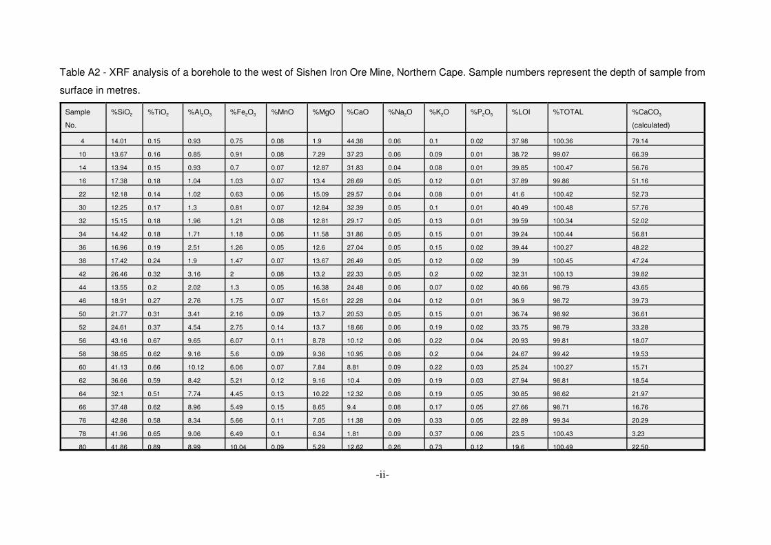
later phases of calcretisation.Fig. 4.33 Joint plane in Unit 8 covered with greenish calcite crystals.Fig. 4.34 Percentage of CaO and SiO2 in samples taken from a borehole to the

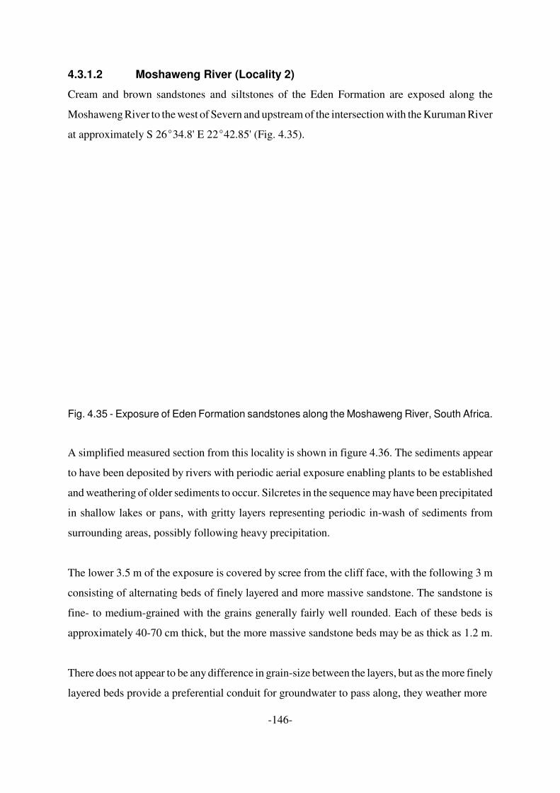
west of the open pit at Sishen Mine, South Africa.Fig. 4.35 Exposure of Eden Formation sandstone along the Moshaweng River,

South Africa.Fig. 4.36 Simplified measured profile through the Kalahari Group sedimentary

rocks exposed along the Moshaweng River (Locality 2).Fig. 4.37 Cavities left by decaying roots were filled in with sandy material. The

sandy infill has subsequently been eroded out.Fig. 4.38 Roots have bleached the sandstone of the Eden Formation. A small hole

is left where the root existed before decaying.Fig. 4.39 Jointing and faulting of the Eden Formation sandstones along the

Moshaweng River.Fig. 4.40 Preferential weathering along one of the joint planes in the Eden

Formation sandstones. Calcretisation of some of the weatheredsandstone has taken place.

Fig. 4.41 Outcrop of Eden Formation sandstones along the Auob River, KalahariGemsbok Park.

Fig. 4.42 Pebble layers at the base of the Eden Formation sandstones outcroppingalong the Auob River, Kalahari Gemsbok Park.

Fig. 4.43 Worm burrows in the Eden Formation weathering out in positive relief,Auob River, Kalahari Gemsbok Park.

Fig. 4.44 Worm burrows in the Eden Formation weathering out in positive relief,Nossob River, Kalahari Gemsbok Park.

Fig. 4.45 Worm tubes in the Eden Formation, Auob River, Kalahari Gemsbok Park.The calcareous filling has been weathered out.

Fig. 4.46 Worm tubes in the Eden Formation, Nossob River, Kalahari GemsbokPark. The calcareous filling has been weathered out.

Fig. 4.47a Nodular calcrete horizon developing in the siltstones overlying the basalpebble horizon, Auob River, Kalahari Gemsbok Park, South Africa.

Fig. 4.47b Calcareous nodules developing in the soft, poorly-consolidatedsedimentary rocks along the Auob River, Kalahari Gemsbok Park, SouthAfrica.

Fig. 4.48 Calcretised layers weathering out in positive relief along the NossobRiver, Kalahari Gemsbok Park, South Africa.

Fig. 4.49 Well developed nodular calcrete horizon along the Nossob River, KalahariGemsbok Park, South Africa.

Fig. 4.50 Solution cavity in the nodular calcrete, Nossob River, Kalahari GemsbokPark, South Africa.

Fig. 4.51 Solution cavities in the calcrete may be filled with fragments of calcreteand re-cemented. In this example in the Kalahari Gemsbok Park ahardpan has formed over the edges of the older solution cavity.

Fig. 4.52 Passarge’s (1904) stratigraphy of the Kalahari sediments (after Thomasand Shaw, 1991a).

Fig. 4.53 Schematic stratigraphy of the Kalahari Group in the Sua Pan area,northern Botswana (after du Plessis, 1993).

Fig. 4.54 The stratigraphy of the Kalahari Group in northern Namibia (after SACS,1980; Miller, 1992a).

Fig. 4.55 The stratigraphy of the Kalahari Group in Bushmanland, Namibia (SACS,1980).

Fig. 4.56 The Kalahari Group sequence in Bushmanland, Namibia (after Balfour,1981).

Fig. 4.57 Stratigraphic variations in the Kalahari Group sedimentary sequence innorthern Namibia (after Miller, 1983).

Fig. 4.58 Stratigraphic variations in the Kalahari Group sedimentary sequence inthe Grootfontein area, Namibia (after Thomas, 1988).

Fig. 4.59 Schematic stratigraphy of the Kalahari Group in Zambia.(after Thomasand Shaw, 1991a).

Fig. 4.60 Stratigraphic variations in the Kalahari Group in Zambia (after Thomasand Shaw, 1991a).

Fig. 4.61 The stratigraphy of the Kalahari Group in Zimbabwe (after Maufe, 1939).Fig. 4.62 Stratigraphic variations in the Kalahari Group in Zimbabwe (after Thomas

and Shaw, 1991a).Fig. 4.63 The stratigraphy of the Kalahari Group in Angola (after Pachero, 1976).Fig. 4.64 The stratigraphy of the Kalahari Group in the DRC (after Claeys, 1947;

Cahen and Lepersonne, 1952; Lepersonne, 1945; Giresse, in press).Fig. 4.65 Proposed litho-stratigraphic sequence for the Kalahari Group.Fig. 4.66 Attempted correlations of the Kalahari Group formations across the

region.

Chapter 5: Regional geomorphology and Kalahari Basin evolution

Fig. 5.1 The African Superswell and stress map of Africa (after Andreoli et al.,1996). The stress indicators are taken from Zoback et al. (1989) andZoback (1992)

Fig. 5.2 Present drainage of southern Africa, showing rivers referred to in the text.Fig. 5.3 Distribution of land surfaces in southern Africa (after Partridge, 1998).Fig. 5.4 Main axes of epeirogenic flexure in southern Africa. Axes identified by du

Toit (1933), King (1963), Meyer (1973), Partridge and Maud (1987).Fig. 5.5 Magnitude of Miocene and Pliocene uplift in southern Africa (after

Partridge,1998). Fig. 5.6 The sub-Kalahari topographical surface.Fig. 5.7 Reconstruction of the mid-Cretaceous drainage of southern Africa (after

Partridge, 1998).Fig. 5.8 Reconstruction of certain pre-African-Surface drainages, prior to

exposure of the Cargonian basement (after Moore and Moore, 2004).Fig. 5.9 The sub-Kalahari topographical surface of the southern Kalahari showing

the position of the mid-Cretaceous Rivers.Fig. 5.10 Isopachs of the basal gravels of the Kalahari Group showing the position

of the mid-Cretaceous rivers.Fig. 5.11 Isopachs of the Kalahari Group showing the position of the mid-

Cretaceous rivers.Fig. 5.12 Southern portion of the sub-Kalahari Geological Map showing the position

of the mid-Cretaceous rivers.

Fig. 5.13 (a) Middle Tertiary drainage in the Molopo drainage area.(b) Late Tertiary drainage in the Molopo drainage area (modified fromBootsman, 1998).

Fig. 5.14 Revised axes of epeirogenic flexure in southern Africa (afterMoore,1999).

Fig. 5.15 Isopachs of the Kalahari Group in the Etosha sub-basin showing theposition of mid-Cretaceous rivers.

Fig. 5.16 The Cunene drainage system (a) > 7 Ma (b) ~ 3 Ma (after Stuart-Williams, 1992).

Fig. 5.17 The Cunene drainage system (a) capture of the upper Cunene by thelower Cunene at ~35 Ka.(b) present drainage system (after Stuart-Williams, 1992).

Fig. 5.18 True colour Terra satellite image of the central Kalahari basin taken onthe 31/03/2002. The image was acquired by Descloitres (2002).

Fig. 5.19 Mid-Cretaceous drainage of the central and eastern Kalahari Basinsuperimposed on the sub-Kalahari topographical surface (drainageconfigurations modified from Thomas and Shaw, 1991a; Moore andLarkin, 2001).

Fig. 5.20 The East African Rift System.Fig. 5.21 Recorded seismic events in southern Africa from 1071 to 1996 (Council

for Geoscience).Fig. 5.22 Main zones of seismicity in the study area.Fig. 5.23 Landsat TM image and elevation contours of the Okavango Delta (after

Gumbricht et al., 2001).Fig. 5.24 Tectonic control over the Okavango Delta and Makgadikgadi Basin (after

Mallick et al., 1981; Shaw and Thomas, 1988).Fig. 5.25 En-echelon pattern of the Kunyere and Thamalakane faults (after Modisi,

2000).Fig. 5.26 Mekgacha networks in the Kalahari (modified from Thomas and Shaw,

1991a).Fig. 5.27 Distribution of pans in South Africa and the palaeo-courses of the

Eenbeker, Tellerie, Gamoep and Koa Rivers (after Malherbe et al., 1986).Fig. 5.28 One of the Sewe Panne, Kalahari Gemsbok Park, South Africa. The pan

is surrounded by lunette dunes which separates it from the remnants ofan older drainage system.

Fig. 5.29 The distribution of pans in the southern part of Botswana (after Lancaster1978b).

Chapter 6: Palaeoclimate

Fig. 6.1 Localities of sites mentioned in the text where palaeoclimatic data hasbeen gathered.

Fig. 6.2 Summary of wet and dry chronologies from the middle and southernKalahari from 200 ka to the present (after Thomas and Shaw, 2002).

Fig. 6.3 Palaeoclimatic reconstruction of rainfall and temperature conditions at thetime of the Last Glacial Maximum at 21000-18000 BP (afterPartridge,1997).

Fig. 6.4 Summary maps of major dated geomorphic and sedimentary evidence oflate Pleistocene environmental changes in the Kalahari 50-10 ka

(Thomas and Shaw, 2002).Fig. 6.5 Palaeoclimatic reconstruction of rainfall and temperature conditions at the

time of the Holocene altithermal at about 7000 BP (after Partridge,1997).Fig. 6.6 Summary of wet and dry chronologies from the middle and southern

Kalahari for the Holocene (after Thomas and Shaw, 2002).

Chapter 7: Mineral potential of the Kalahari Basin (2)

Fig. 7.1 The distribution of kieselguhr deposits in South Africa (data fromSamindaba, Council for Geoscience).

Fig. 7.2 Schwarz’s 1920 scheme for irrigating the Kalahari Desert (after Schwartz,1920; Thomas and Shaw, 1991a).

Chapter 8: Discussion and conclusions (10)

Fig. 8.1 Summary of the mid-Cretaceous drainage of southern Africasuperimposed on the sub-Kalahari topographical surface.

Fig. 8.2 Profiles constructed from the sub-Kalahari topographical surface alongthe proposed Cretaceous courses of the Okavango, Kwando andZambezi rivers. Axes of Cenozoic uplift and downwarp are shown on theprofiles.

Fig. 8.3 Topographic profiles constructed along lines of latitude across the sub-Kalahari topographical surface.

Fig. 8.4 The axes of Late Tertiary and Quaternary uplift, rifting/subsidence andseismicity in the Kalahari Basin.

LIST OF TABLES

Table 4.1 Macrofossils, diatoms and ostracods found in the diatomaceous depositsat Lonely Farm on the Kuruman River and at Sewe and Bayip Panne inthe Kalahari Gemsbok Park (Thomas, 1981; Malherbe, 1984).

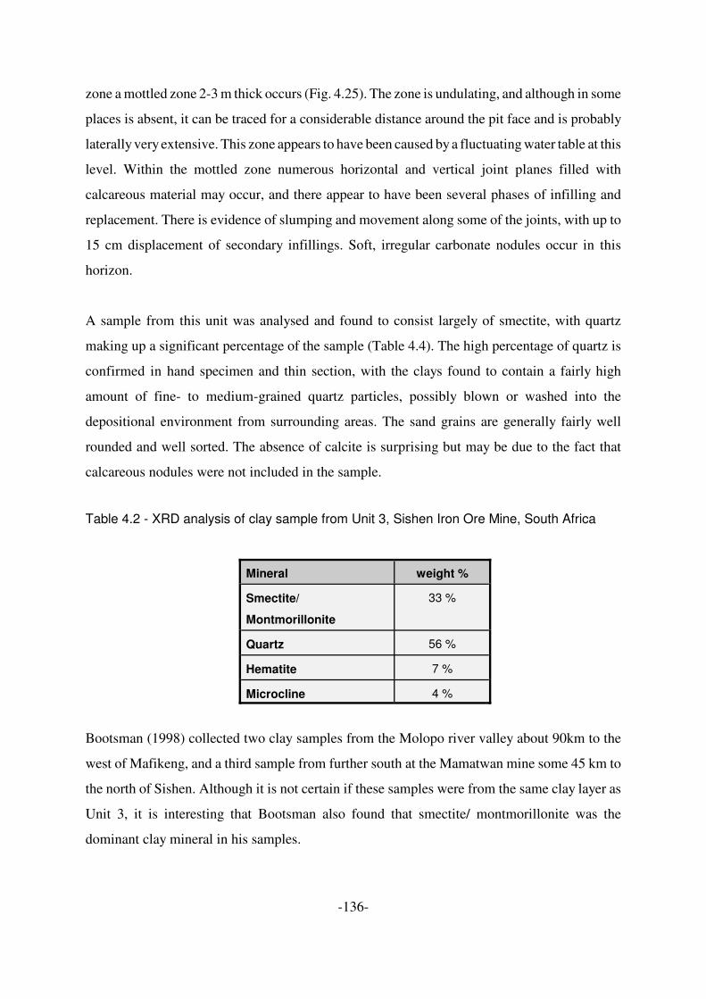
Table 4.2 XRD analysis of clay sample from Unit 3, Sishen Iron Ore Mine, SouthAfrica

Table 4.3 Analysis of the clay mineral component of samples from the North-WestCape (after Bootsman, 1998).

Table 7.1 Analysis of sepiolite from Nui-Sei 376 (Levin, 1996).

APPENDIX LIST

Appendix A:

Table A1 XRF Analyses of a red clay from Sishen Mine (Ehlers and Wilson, 2001).Table A2 XRF analysis of a borehole to the west of Sishen Iron Ore Mine, Northern

Cape. Sample numbers represent the depth of sample from surface inmetres.

Table A3 XRF analysis of a borehole to the west of Sishen Iron Ore Mine, NorthernCape. Sample numbers represent the depth of sample from surface inmetres.

Appendix B:

Isopach map of the Kalahari Group

Appendix C:

Sub-Kalahari Geological Map

Appendix D:

Isopach map of the basal gravels

Appendix E:

Sub-Kalahari Topographical map

CONTENTS

CHAPTER 1: INTRODUCTION . . . . . . . . . . . . . . . . . . . . . . . . . . . . . . . . . . . . . . . . 1

CHAPTER 2: METHODOLOGY . . . . . . . . . . . . . . . . . . . . . . . . . . . . . . . . . . . . . . . 82.1 Introduction . . . . . . . . . . . . . . . . . . . . . . . . . . . . . . . . . . . . . . . . . . . . . 82.2 The compilation of the Kalahari Group Isopach, Basement Gravel

Isopach, Sub-Kalahari Geological and Sub-Kalahari TopographicalMaps . . . . . . . . . . . . . . . . . . . . . . . . . . . . . . . . . . . . . . . . . . . . . . . . . . 92.2.1 Borehole database compilation . . . . . . . . . . . . . . . . . . . . . . . . 92.2.2 Borehole data processing . . . . . . . . . . . . . . . . . . . . . . . . . . . . 102.2.3 Addition of mapped and published data . . . . . . . . . . . . . . . . . 112.2.4 GIS manipulation of data . . . . . . . . . . . . . . . . . . . . . . . . . . . . 13

2.3 Kalahari Group stratigraphy . . . . . . . . . . . . . . . . . . . . . . . . . . . . . . . 152.4 Palaeo-drainage reconstruction and model of basin development . . 16

CHAPTER 3: SUB-KALAHARI GEOLOGY . . . . . . . . . . . . . . . . . . . . . . . . . . . . . . 183.1 Introduction . . . . . . . . . . . . . . . . . . . . . . . . . . . . . . . . . . . . . . . . . . . . 183.2 Evolution of continental crust . . . . . . . . . . . . . . . . . . . . . . . . . . . . . . 24

3.2.1 Archaean Greenstones . . . . . . . . . . . . . . . . . . . . . . . . . . . . . 263.2.2 Archaean granites and gneisses . . . . . . . . . . . . . . . . . . . . . . 26

3.3 Developments on the cratons . . . . . . . . . . . . . . . . . . . . . . . . . . . . . . 263.3.1 Dominion Group and Witwatersrand Supergroup . . . . . . . . . . 273.3.2 Mabuasehube Group . . . . . . . . . . . . . . . . . . . . . . . . . . . . . . . 273.3.3 Lobatse Group and Kanye Formation . . . . . . . . . . . . . . . . . . 273.3.4 The Gaborone, Mmathethe, and Mosita Granites . . . . . . . . . 283.3.5 Limpopo Belt . . . . . . . . . . . . . . . . . . . . . . . . . . . . . . . . . . . . . 283.3.6 Ventersdorp Supergroup . . . . . . . . . . . . . . . . . . . . . . . . . . . . 293.3.7 Transvaal Supergroup . . . . . . . . . . . . . . . . . . . . . . . . . . . . . . 293.3.8 Cassinga Supergroup . . . . . . . . . . . . . . . . . . . . . . . . . . . . . . . 333.3.9 Lower Proterozoic intrusives . . . . . . . . . . . . . . . . . . . . . . . . . . 34

3.4 Assembly of supercontinents . . . . . . . . . . . . . . . . . . . . . . . . . . . . . . 343.4.1 The Okwa Complex, Kheis and Magondi Belts and the Kalahari

Suture Zone . . . . . . . . . . . . . . . . . . . . . . . . . . . . . . . . . . . . . . 353.4.2 Waterberg Supergroup . . . . . . . . . . . . . . . . . . . . . . . . . . . . . . 413.4.3 Palapye Group . . . . . . . . . . . . . . . . . . . . . . . . . . . . . . . . . . . . 413.4.4 Khoabendus Group . . . . . . . . . . . . . . . . . . . . . . . . . . . . . . . . 423.4.5 The Kibaran Belt . . . . . . . . . . . . . . . . . . . . . . . . . . . . . . . . . . . 423.4.6 The Cunene (Kunene) Complex . . . . . . . . . . . . . . . . . . . . . . . 433.4.6 The Namaqua-Natal accretion . . . . . . . . . . . . . . . . . . . . . . . . 443.4.7 The Quangwadum Group and the Grootfontein, Huab and

Kwando Complexes . . . . . . . . . . . . . . . . . . . . . . . . . . . . . . . . 453.4.8 The Irumide Belt . . . . . . . . . . . . . . . . . . . . . . . . . . . . . . . . . . . 463.4.9 The Koras-Sinclair-Ghanzi Rift . . . . . . . . . . . . . . . . . . . . . . . . 47

3.5 The break-up of Rodinia and the Pan-African event . . . . . . . . . . . . . 533.5.1 The Lufilian and Zambezi Belts . . . . . . . . . . . . . . . . . . . . . . . 533.5.2 The West Congolian Supergroup . . . . . . . . . . . . . . . . . . . . . . 573.5.3 The Damara Belt . . . . . . . . . . . . . . . . . . . . . . . . . . . . . . . . . . 57

3.5.4 The Passarge Basin . . . . . . . . . . . . . . . . . . . . . . . . . . . . . . . . 633.5.5 The Nama and Okwa Groups . . . . . . . . . . . . . . . . . . . . . . . . . 64

3.6 Karoo Supergroup deposition and the break-up of Gondwana . . . . . 653.6.1 Carboniferous . . . . . . . . . . . . . . . . . . . . . . . . . . . . . . . . . . . . . 673.6.2 Carboniferous- Permian . . . . . . . . . . . . . . . . . . . . . . . . . . . . . 673.6.3 Permian . . . . . . . . . . . . . . . . . . . . . . . . . . . . . . . . . . . . . . . . . 693.6.4 Late Permian-Early Triassic . . . . . . . . . . . . . . . . . . . . . . . . . . 703.6.5 Rifting and the break up of Gondwana . . . . . . . . . . . . . . . . . . 723.6.6 Kimberlites . . . . . . . . . . . . . . . . . . . . . . . . . . . . . . . . . . . . . . . 79

3.7 The Morokweng Impact Structure . . . . . . . . . . . . . . . . . . . . . . . . . . . 803.8 Cretaceous Sediments . . . . . . . . . . . . . . . . . . . . . . . . . . . . . . . . . . . 833.9 Conclusions . . . . . . . . . . . . . . . . . . . . . . . . . . . . . . . . . . . . . . . . . . . . 84

CHAPTER 4: DISTRIBUTION AND LITHOSTRATIGRAPHY OF THE KALAHARIGROUP . . . . . . . . . . . . . . . . . . . . . . . . . . . . . . . . . . . . . . . . . . . . . . . . . . . . 854.1. Introduction . . . . . . . . . . . . . . . . . . . . . . . . . . . . . . . . . . . . . . . . . . . . . . 854.2. Lithologies . . . . . . . . . . . . . . . . . . . . . . . . . . . . . . . . . . . . . . . . . . . . . . . 89

4.2.1 Basal conglomerate and gravel . . . . . . . . . . . . . . . . . . . . . . . 894.2.2 Clay . . . . . . . . . . . . . . . . . . . . . . . . . . . . . . . . . . . . . . . . . . . . 904.2.3 Sandstone . . . . . . . . . . . . . . . . . . . . . . . . . . . . . . . . . . . . . . . 914.2.4 Duricrusts . . . . . . . . . . . . . . . . . . . . . . . . . . . . . . . . . . . . . . . . 924.2.5 Unconsolidated Sand . . . . . . . . . . . . . . . . . . . . . . . . . . . . . . 1014.2.6 Pan sediments and Diatomaceous Deposits (Kieselguhr) . . 117

4.3 The Stratigraphy of the Kalahari Group and regional stratigraphicvariations . . . . . . . . . . . . . . . . . . . . . . . . . . . . . . . . . . . . . . . . . . . . . 1224.3.1 Stratigraphy of the Kalahari Group in South Africa . . . . . . . . 1224.3.2 Stratigraphy of the Kalahari Group in Botswana . . . . . . . . . 1594.3.3 Stratigraphy of the Kalahari Group in Namibia . . . . . . . . . . . 1624.3.4 Stratigraphy of the Kalahari Group in Zambia . . . . . . . . . . . 1654.3.5 Stratigraphy of the Kalahari Group in Zimbabwe . . . . . . . . . 1694.3.6 Stratigraphy of the Kalahari Group in Angola . . . . . . . . . . . . 1714.3.7 Stratigraphy of the Kalahari Group in the Democratic Republic

of Congo . . . . . . . . . . . . . . . . . . . . . . . . . . . . . . . . . . . . . . . . 1734.4 Discussion . . . . . . . . . . . . . . . . . . . . . . . . . . . . . . . . . . . . . . . . . . . . 174

CHAPTER 5: REGIONAL GEOMORPHOLOGY AND KALAHARI BASINEVOLUTION . . . . . . . . . . . . . . . . . . . . . . . . . . . . . . . . . . . . . . . . . . . . . . . 1775.1 Introduction . . . . . . . . . . . . . . . . . . . . . . . . . . . . . . . . . . . . . . . . . . . 1775.2 Cretaceous and Cenozoic uplift . . . . . . . . . . . . . . . . . . . . . . . . . . . 1815.3 Drainage evolution and basin formation . . . . . . . . . . . . . . . . . . . . . 187

5.3.1 Drainage evolution of the southwestern Kalahari Basin . . . . 1895.3.2 Drainage evolution of the Etosha sub-basin, western Kalahari

Basin . . . . . . . . . . . . . . . . . . . . . . . . . . . . . . . . . . . . . . . . . . 2035.3.3 Drainage evolution of the central and eastern parts of the

Kalahari Basin . . . . . . . . . . . . . . . . . . . . . . . . . . . . . . . . . . . 2105.3.4 The Congo Basin . . . . . . . . . . . . . . . . . . . . . . . . . . . . . . . . . 2315.3.5 The mekgacha of the central southern Kalahari Basin . . . . . 2335.3.6 Pans . . . . . . . . . . . . . . . . . . . . . . . . . . . . . . . . . . . . . . . . . . . 235

5.4 Conclusions . . . . . . . . . . . . . . . . . . . . . . . . . . . . . . . . . . . . . . . . . . . 241

CHAPTER 6: PALAEOCLIMATE . . . . . . . . . . . . . . . . . . . . . . . . . . . . . . . . . . . . . 2436.1 Introduction . . . . . . . . . . . . . . . . . . . . . . . . . . . . . . . . . . . . . . . . . . . 2436.2 Evidence for climatic change . . . . . . . . . . . . . . . . . . . . . . . . . . . . . 2476.3 Conclusions . . . . . . . . . . . . . . . . . . . . . . . . . . . . . . . . . . . . . . . . . . . 259

CHAPTER 7: MINERAL POTENTIAL OF THE KALAHARI BASIN . . . . . . . . . . . 2607.1 Introduction . . . . . . . . . . . . . . . . . . . . . . . . . . . . . . . . . . . . . . . . . . . 2607.2 Archaean . . . . . . . . . . . . . . . . . . . . . . . . . . . . . . . . . . . . . . . . . . . . . 260

7.2.1 Gold and Nickel . . . . . . . . . . . . . . . . . . . . . . . . . . . . . . . . . . 2607.3 Proterozoic . . . . . . . . . . . . . . . . . . . . . . . . . . . . . . . . . . . . . . . . . . . 261

7.3.1 Iron and Manganese . . . . . . . . . . . . . . . . . . . . . . . . . . . . . . 2617.3.2 Asbestos . . . . . . . . . . . . . . . . . . . . . . . . . . . . . . . . . . . . . . . . 2617.3.3 Intrusive complexes . . . . . . . . . . . . . . . . . . . . . . . . . . . . . . . 2627.3.4 Copper, Lead, Zinc . . . . . . . . . . . . . . . . . . . . . . . . . . . . . . . . 262

7.4 Palaeozoic . . . . . . . . . . . . . . . . . . . . . . . . . . . . . . . . . . . . . . . . . . . . 2647.4.1 Coal . . . . . . . . . . . . . . . . . . . . . . . . . . . . . . . . . . . . . . . . . . . 264

7.5 Mesozoic . . . . . . . . . . . . . . . . . . . . . . . . . . . . . . . . . . . . . . . . . . . . . 2647.5.1 Diamonds . . . . . . . . . . . . . . . . . . . . . . . . . . . . . . . . . . . . . . . 265

7.6 Cenozoic . . . . . . . . . . . . . . . . . . . . . . . . . . . . . . . . . . . . . . . . . . . . . 2677.6.1 Tertiary diatomites, clays and evaporites . . . . . . . . . . . . . . . 2677.6.3 Heavy mineral deposits . . . . . . . . . . . . . . . . . . . . . . . . . . . . 270

7.7 Groundwater . . . . . . . . . . . . . . . . . . . . . . . . . . . . . . . . . . . . . . . . . . 2707.8 Construction materials . . . . . . . . . . . . . . . . . . . . . . . . . . . . . . . . . . 2737.9 Conclusions . . . . . . . . . . . . . . . . . . . . . . . . . . . . . . . . . . . . . . . . . . . 273

CHAPTER 8: DISCUSSION AND CONCLUSIONS . . . . . . . . . . . . . . . . . . . . . . 2748.1 Introduction . . . . . . . . . . . . . . . . . . . . . . . . . . . . . . . . . . . . . . . . . . . 2748.2 The influence of the pre-Kalahari geology on Kalahari basin

development . . . . . . . . . . . . . . . . . . . . . . . . . . . . . . . . . . . . . . . . . . 2748.3 Cretaceous drainage . . . . . . . . . . . . . . . . . . . . . . . . . . . . . . . . . . . . 2778.4 Basin formation: Uplift or downwarp? . . . . . . . . . . . . . . . . . . . . . . . 2778.5 Initial Kalahari Group deposition . . . . . . . . . . . . . . . . . . . . . . . . . . . 2838.6 Regional uplift . . . . . . . . . . . . . . . . . . . . . . . . . . . . . . . . . . . . . . . . . 284

8.6.1 Miocene uplift and continued sedimentation . . . . . . . . . . . . 2878.6.2 Pliocene uplift and resultant deposition of the unconsolidated

sands . . . . . . . . . . . . . . . . . . . . . . . . . . . . . . . . . . . . . . . . . . 2878.6.3 Pleistocene and Quaternary uplift, rifting and erosion . . . . . 290

8.7 Final conclusions . . . . . . . . . . . . . . . . . . . . . . . . . . . . . . . . . . . . . . . 294

REFERENCES . . . . . . . . . . . . . . . . . . . . . . . . . . . . . . . . . . . . . . . . . . . . . . . . . . . 296

APPENDICES . . . . . . . . . . . . . . . . . . . . . . . . . . . . . . . . . . . . . . . . . . . . . . . . . . . . . i

-1-

CHAPTER 1: INTRODUCTION

While much research has been conducted on the Kalahari Group in the last one hundred years,

from Passarge’s (1904) detailed account of the geology of Botswana, Die Kalahari, to the

application of modern dating techniques (e.g. Thomas et al., 2000; Stokes et al., 1997a,b) and

the more recent syntheses of data (e.g. Thomas and Shaw, 1990, 1991a, 2002; Haddon, 2000;

Haddon and McCarthy, in press), inadequate attention has been paid to understanding the

tectonic evolution of the region in general and the development of the Kalahari Basin in

particular. An understanding of the geology of the Kalahari Basin, as well as the sub-Kalahari

geology and structure, is vital to the understanding of the geology and geomorphology of

southern Africa, as Kalahari Group sedimentary rocks cover large portions of seven southern

African countries (Fig. 1.1), stretching some 2200 km from South Africa in the south, northwards

through Botswana, and up into Angola. In northern Angola, the Kalahari Basin appears to narrow

before extending about 200 km into the Democratic Republic of the Congo, but Kalahari Group

sediments were probably originally deposited over a large part of the Democratic Republic of the

Congo as well as into countries even further to the north. A large percentage of the Kalahari

Group sediments deposited in the Congo Basin appear to have subsequently been eroded by the

Congo River and its tributaries, but some of the Cretaceous deposits found in the Congo Basin

may be the equivalent of basal Kalahari Group deposits found further south. The upper unit of

the Kalahari Group, the unconsolidated sands, cover an area of some 2.5 million km2 (Thomas

and Shaw, 1991a), which according to Baillieul (1975) makes it the largest continuous erg on

earth. A country like Angola, with its vast potential wealth and largely unexplored interior, has

more than 55% of its land area covered by the unconsolidated Kalahari sands; 30% of Namibia

and 25% of Zambia are covered and Botswana, with its massive diamond wealth, has a cover of

Kalahari sedimentary rocks over some 75% of the country.

The name Kalahari itself has many connotations and it is important to establish the terminology

to be used in this work. “Kalahari” (derived from the word Kgalagadi) means “the great thirst”

and the Kalahari Desert is perhaps best known for its arid climate, the Okavango swamps and

the indigenous San (otherwise known as Bushmen or Basarwa) people living in the region.

-2-

Fig 1.1

-3-

This semi-arid area stretches from the northern Cape Province of South Africa to northern

Botswana and Namibia, and is therefore far smaller than the area covered by the Kalahari Group

sedimentary rocks. In a geological sense, the term “Kalahari Basin” is also misleading. In several

publications, of which Johnson et al. (1996) is one of the most recent and notable, the Kalahari

Basin is the name given to the Karoo Supergroup-filled sub-basin that trends roughly northeast-

southwest across central Botswana. This obviously results in the unsatisfactory situation whereby

the Kalahari Basin used in the Karoo context has nothing to do with the Kalahari Group itself.

It is proposed after consultation with Dr M.R. Johnson, the secretary of the South Africa

Committee for Stratigraphy (SACS), that the Karoo sub-basin centred on Botswana be referred

to as the Botswana Basin (e.g. R.A. Smith, 1984; Partridge, 1998; Partridge and Maud, 2000).

In this study, the term Kalahari Basin will be used in reference to the depositional basin into

which Kalahari Group sedimentary rocks were deposited.

Climate

The southern part of the Kalahari Basin falls within the borders of Namibia, Botswana,

Zimbabwe and South Africa and is characterised by semi-arid to arid conditions. The region is,

however, characterised by a strong NE-SW precipitation gradient which is due to the contrasts

in sea surface temperature between the South Atlantic and Indian Oceans off the coasts of

southern Africa (Stokes et al., 1997b). Mean precipitation is around 150 to 250 mm per annum

in the southwest (Tyson, 1986; van Rooyen and Bredenkamp, 1996a), about 600 mm per annum

in northern Botswana, 972 mm per annum in western Zambia (Thomas, 1984a; Thomas et al.,

2003) and 1400 mm in northern Angola and southern Democratic Republic of Congo (Vetter,

2004). Evaporation rates are very high, and in the summer months can be up to six times greater

than the precipitation (Meyer et al., 1985). Daily ranges of temperature can be extreme, with

temperatures in the southwestern basin ranging from -10EC in winter and up to 45EC in summer

(van Rooyen and Bredenkamp, 1996a).

Vegetation

More than 400 species of plant are found in the Kalahari with a gradation from the drier open

shrublands of the extreme south, through the savannas of the central basin, to the broad leafed

deciduous forests of the north. Most of the area falls within the Savannah biome, which is

predominantly characterised by grasses of mainly the C4-type, as well as shrubs and trees. In the

-4-

southwestern parts of the basin the deep sandy soils of the Kgalagadi Transfrontier Park are

characterised by Camel Thorn (Acacia erioloba) trees, Belly Thorn (Acacia luederitzii),

Shepard’s Tree (Boscia albitrunca), as well as Silver Clusterleaf (Terminalia sericea) occurring

on some dune crests (van Rooyen and Bredenkamp, 1996a; Weare and Yalala, 1971). To the east

and southwest of this area Grey Camel Thorn (Acacia haematoxylon) becomes more common

as well as shrubs of Black Thorn (Acacia mellifera), Weeping Candle Thorn (Acacia hebeclada),

Karee Thorn (Lycium hirsutum) and scattered individual plants of Bastard Roughleaf Raisin

(Greia retinervis) and Kalahari Currant (Rhus tenuinervis)(van Rooyen and Bredenkamp,

1996b,c). A surface creeping plant, the Tsamma (Citrullus lanatus) is found throughout the drier

portions of the Kalahari Basin and along with gemsbok cucumbers (Acanthosicyos naudinianus),

and wild cucumbers (Cucumis africanus) are important sources of water for various antelope

species. The Wilde Okkerneut tree (Ricinodendron Rautennii) is also known for an edible fruit

(the Manketti nut). Eastern Namibia and central and southeastern Botswana are characterised by

Silver Clusterleaf, Camel Thorn, Wild Seringa (Burkea africana), African wattle (Peltophorum

africanum) and Knob Thorn (Acacia nigrescens)(Weare and Yalala, 1971), with areas of

shallower bedrock in western Botswana additionally characterised by the Red Umbrella thorn

(Acacia reficiens) and Russet Bushwillow (Combretum hereoense)(Cole and Le Roex, 1978).

Kalahari Sand Apple (Lonchocarpus nelsii), stretches across the central part of the basin from

Namibia into western Zimbabwe (Weare and Yalala, 1971) and the trees and shrubs and areas

to the south of N’Gwaku Pan are characterised by woodlands of Umbrella Thorn (Acacia tortilis)

and the Blue Thorn (Acacia erubescens)(Cole and Le Roex, 1978). Areas of calcrete

development in the entire area from Windhoek in Namibia through to the southwestern parts of

the Okavango Delta are characterised by Trumpet Thorns (Catophractes alexandrii)(Cole and

Le Roex, 1978) and Baobab trees (Adansonia digitata) are found around the Makgadikgadi pans.

Towards the north and northeast of the basin, in Zimbabwe, Zambia, Angola and into the

Democratic Republic of Congo, the climate becomes progressively wetter, with the dune ridges

characterised by woodlands (Van Zinderen Bakker and Clark, 1962). Mopane (Colophospermum

mopane), Rhodesian teak (Baikiaea plurijuga) and Marula (Sclerocarya birrea) trees are found

in the dry deciduous forest of northeastern Namibia, southern Angola, northern Botswana,

northwestern Zimbabwe and southern Zambia, with the dunes of western Zimbabwe additionally

characterised by Musasa/Mtundu (Brachystegia spiciformis)and Mukwa (Pterocarpus

angolensis) (Sutton, 1979). Western Zambia and central and eastern Angola are characterised by

-5-

woodland dominated by the African Blackwood (Erythrophleum Africanum), Ebony (Diospyros

batocana) and trees belonging to the Brachystegia genera, while the dense woodlands of

northwestern Zambia are also characterised by Mukwe (Cryptosepalum exfoliatum pseudotaxus)

(Vetter, 2004). The Okavango Delta and adjacent wetland areas are characterised by swamps

filled with reeds and other aquatic plants.

Human activity

Evidence of human activity in the Kalahari extends as far back as the Early Stone Age with

artefacts from this period being found at various sites in and around the basin (see review in

Thomas and Shaw, 1991a). Until as recently as 2000-1500 years ago the Kalahari was inhabited

exclusively by the San people who survived as hunters and gatherers. The arrival of Bantu people

and European settlers changed the way of life in the region, with permanent farms becoming

dominant. Today large game, cattle, sheep and goat farms cover the majority of the area along

with several reserves set aside for the preservation of flora and fauna. These reserves cater for

a large tourist industry attracted by the high concentration of wildlife as well as the beauty of the

Kalahari Desert and the Okavango Delta and Makgadikgadi and Etosha pans. Today, major

settlements are predominantly found around the edges of the basin although some small towns

have developed around the sites of mines (e.g. Orapa) while others have seen growth along with

a boom in the tourist industry (e.g. Maun). The regional road network becomes markedly less

dense in the basin itself, although a trans-Kalahari highway now links South Africa and

Gaborone with Namibia (Fig.1.2).

Aims

This study concentrates on the area covered by Kalahari Group deposits to the south of the

Democratic Republic of the Congo. It is the aim of this study not only to present a synthesis of

available information for the entire Kalahari Basin, but also to generate new data, model and

combine existing data and present the resultant interpretations of Kalahari Basin evolution.

Previously published and unpublished as well as new borehole, geophysical, and geological data

are used to produce maps showing the thickness of Kalahari Group sedimentary rocks, the

geology underlying the Kalahari Group rocks, and the topography of the sub-Kalahari surface.

The large size of the area covered and the complexity of the geology does not enable all aspects

of the Kalahari Basin to be covered in equal detail, but an attempt has been made to describe the

-6-

-7-

sub-Kalahari geology as well as the Kalahari Group stratigraphy and to identify those factors

deemed to have played an important part in the basin evolution. The southern African rivers and

their distribution both during and after basin formation provide important evidence for basin

evolution and an effort has been made to understand the factors which controlled the drainage

patterns. The timing of basin formation and the deposition of Kalahari Group sedimentary rocks

is discussed and the tectonic influences that have acted on the basin subsequently are described.

A brief chapter on the mineral potential of the area is included in order to illustrate the potential

the region has for mineral exploration and it is hoped that this work will help to promote interest

in furthering research, development and mineral exploration in the area.

-8-

CHAPTER 2: METHODOLOGY

2.1 Introduction

The Southern African Development Community (SADC) Kalahari Working Group provided the

initial impetus for a Kalahari Basin study by identifying that there was a need to produce maps

showing the thickness of Kalahari Group sedimentary rocks as well as the distribution and nature

of the geological units beneath the Kalahari Group rocks for the SADC region. The “Isopach

Map of the Kalahari Group” and “Sub-Kalahari Geological Map” (see Appendix B and C) to be

produced were to show the thicknesses of Kalahari Group rocks and the geology underlying the

Kalahari Group respectively for South Africa, Namibia, Botswana, Zimbabwe, Zambia, and

Angola. The Democratic Republic of Congo (DRC) was not included at the time of the project

initiation as at that stage it was not a member of SADC. All data compilation and digital capture

as well as construction of databases and GIS manipulation of the data was carried out by the

author who was assisted with some of the more complicated GIS modelling by various staff at

the Council for Geoscience.

Following the preparation of the two maps it was clear that further research on the Kalahari Basin

needed to be conducted, firstly in order to complement and provide an explanation for the two

maps and secondly to identify the sequence of tectonic and climatic events that influenced the

formation and evolution of the Kalahari Basin. The substantial amount of literature and data that

exists for the Kalahari Basin provided the major source of information for this study and the

compilation and synthesis of this information was seen as one of the major objectives of the

project. Field and laboratory descriptions of Kalahari Group rocks as well as the interpretation

of the maps provided additional data and insight into the evolution of the Kalahari Basin. The

production of a map showing the thicknesses of the basal gravels of the Kalahari Group in South

Africa (Appendix D) was attempted in order to better understand where the main palaeo-channels

lie as this is not only of importance to understanding basin evolution but also has economic

significance for diamond and water exploration. While the isopach maps provide valuable

information, it was also decided to model the sub-Kalahari Group topography in order to better

-9-

understand basin evolution. The production of the Sub-Kalahari topographical surface (Appendix

E) has provided valuable new information regarding basin development.

2.2 The compilation of the Kalahari Group Isopach, Basement Gravel Isopach,

Sub-Kalahari Geological and Sub-Kalahari Topographical Maps

2.2.1 Borehole database compilation

Information for the Kalahari isopach and sub-Kalahari geology maps was obtained from national

representatives on the Kalahari Working Group, directly from the various national Geological

Surveys, from several mining and mineral exploration companies and from private geological

and groundwater consultancies. The data used for the compilation of the maps came in four main

forms:

• borehole data (Kalahari Group lithologies and thicknesses and basement rock

types)

• geological maps

• geological reports, journal papers, published books

• geophysical data

In order to gather this information visits were made to the Geological Survey Departments of

Botswana, Namibia, Zambia, Angola and Zimbabwe, as well as to the Department of Water

Affairs offices in Namibia. In addition to this, private consultancies and mining companies that

had borehole information were approached in each of these countries during each visit. On

average a period of one and a half to two weeks was spent in each country gathering relevant

data.

In excess of 30 000 boreholes drilled into the Kalahari Group sediments were analysed, evaluated

and, depending on their reliability and detail, it was decided which of these would eventually be

used for the production of the map. Each borehole log was individually assessed according to the

following criteria:

-10-

• accuracy of locality data

• accuracy and detail of lithological descriptions

The borehole logs that were considered to contain data with high levels of accuracy according

to these criteria were then entered into a new Paradox-based database. The borehole data was

then sorted, edited, evaluated, assigned a unique number and individually coded to enable data

such as thickness of the Kalahari Group sedimentary rocks and sub-Kalahari lithology to be

easily queried and extracted. Those boreholes which did not reach the base of the Kalahari were

assigned different codes and their logs were kept separately for later manual interpretation of

sediment thicknesses for those areas with sparse data coverage. Where possible, borehole core

and percussion chips from various countries were examined in order to more accurately ascertain

the depth of the base of the Kalahari Group, and what the underlying lithologies consist of.

Where the lithologies described in the logs appeared confused or unreliable, the data from these

logs was discarded.

Of the initial 30 000 boreholes only 7 074 were thought to be detailed and reliable enough for

use in the production of the isopach and sub-Kalahari geology maps. The majority of the data

used falls within the borders of South Africa, Botswana and Namibia, and very little data exists

for Angola and Zambia (see “Isopach Map of the Kalahari Group” Appendix B). From these 7

074 borehole logs two separate data files were created in Paradox: the first (co-ordinate file)

containing unique number, longitude and latitude and the second (data file) containing unique

number, borehole number, thickness of Kalahari Group rocks and sub-Kalahari lithology. The

borehole data was then exported as ASCII comma delimited files and imported into the ArcINFO

6 GIS system. The gathering and preparation of the borehole data took about one year.

2.2.2 Borehole data processing

In ArcINFO 6 the borehole data co-ordinate files were generated and then built as point

coverages. This created a point attribute table (PAT). INFO was then used to define the structure

of an attributes table into which the data from the data file would be placed. Data was then added

to the newly defined attribute table, and this in turn was joined to the points table. The result of

this was to create a coverage showing the positions of the boreholes with attached lithological

-11-

and thickness data.

2.2.3 Addition of mapped and published data

2.2.3.1 Kalahari isopach map

The areas on the isopach map where the sub-Kalahari rocks are exposed form an important

additional source of thickness data that needed to be included on the map. Published and

unpublished 1: 250 000 and 1: 1000 000 geological maps of the region were used to delineate

the furthest most extent of the Kalahari Group sedimentary rocks as well as to show where pre-

Kalahari rocks outcrop. Twenty 1: 250 000 maps were used as a source of data for Namibia, and

12 for South Africa. For the other countries, 1: 1000 000 scale maps were mainly used. Overlays

showing the outcrop areas of sub-Kalahari rocks were drawn on a stable base in preparation for

digitising.

Kalahari Group isopachs shown on earlier maps in the Morokweng area of South Africa (Smit,

1977) were digitised and brought into ArcINFO as a separate coverage. Where new data was

available, it was used to modify these isopachs. The Morokweng isopachs were added to the

borehole data in order to improve data density in areas of limited borehole coverage.

Isopachs from the published 1: 1000 000 geological map of Angola (Serviço Geológico de

Angola, 1988) were included as borehole data from Angola was sparse and in many cases was

considered to be inaccurate. The source of the data used for the Angolan isopachs and the

accuracy of the isopachs is not known and it is possible that some pre-Kalahari Group Cretaceous

sedimentary rocks may have been included with the Kalahari Group. Unfortunately it is

extremely difficult to obtain accurate and reliable borehole logs from the areas of Angola covered

by Kalahari Group rocks.

2.2.3.2 Basal gravels isopach map

The same base data used for the isopach map of the Kalahari Group was used for the construction

of the isopachs of the basal gravels.

2.2.3.3 Sub-Kalahari geology map

-12-

In order to prepare a base map onto which borehole data could be added and interpreted, all

available geological maps for the area were consulted. In the case of some of the countries, 1: 250

000 scale geological maps exist, and these were used as a base map onto which other data could

be added. For Namibia, 20 1: 250 000 maps exist for the area covered by the Kalahari Group

rocks and for some of these areas sub-Kalahari geology had been interpreted by Dr W.

Hegenberger of the Geological Survey of Namibia. The latest edition of the 1: 1000 000

geological map of Botswana already shows the sub-Kalahari geology and as a result was added

with only minor changes where new data had become available. For Angola, Zambia and

Zimbabwe the national 1: 1000 000 scale geological maps were used as base maps, and for South

Africa 12 separate 1: 250 000 maps were used for the base maps, none of which showed any

sub-Kalahari geology.

Borehole data containing sub-Kalahari lithological information was then overlain on the

geological maps of all the countries. The sub-Kalahari data retrieved from these boreholes was

directly used to determine the distribution of geological units underlying the Kalahari Group

rocks. Geological detail down to formation level is shown where possible. Where there were

large gaps in borehole distribution and the geological maps did not indicate the nature of sub-

Kalahari lithologies, all published and unpublished geological reports from the area were studied

for information. Geophysical data, which included previously interpreted and raw data, was used

particularly in areas where other data was absent. In particular, aeromagnetic and gravity data

enabled further interpolations to be made by highlighting some of the most important pre-

Kalahari structures and magnetic units.

A “buffer zone” of outcropping pre-Kalahari units was included on the map around the edge of

the Kalahari Basin in order to provide continuity between the interpolated geology beneath the

Kalahari sedimentary rocks and the surface geology that has been mapped previously.

2.2.3.4 Sub-Kalahari Group topographical map

The same base data used for the isopach map of the Kalahari Group was used for the construction

of the sub-Kalahari topography. This involved selecting areas of sub-Kalahari outcrop as well

as adding in some of the previously mapped isopachs from areas where borehole data was

insufficient. The DEM used in the GIS processing of the data is the USGS SRTM30 DEM, which

-13-

is the original GTOPO30 DEM enhanced by data from the Shuttle Radar Topography Mission

flown in February 2000 (USGS, 2004).

2.2.4 GIS manipulation of data

The necessary information from each of the maps showing pre-Kalahari outcrops and sub-

Kalahari geology was digitised using AutoCAD, with these digitised maps then being exported

as DXF files and then imported into ArcINFO. TIC coverages for each map were created in

ArcINFO and the maps were then “transformed” to these TIC coverages. Once the maps were

geographically referenced and were in the Arc Info system the following steps were followed:

1. All maps were projected to a common projection.

2. The ArcEdit command “Get” was used to bring individual maps into a common coverage

for each country.

3. Polygons and arcs were edited in ArcEdit in order to produce composite maps of

individual countries, and the individual map coverages, now geo-referenced, were then

edited and finally were joined together using ArcEdit.

2.2.4.1 Isopach maps

ArcINFO 6 software was chosen to model the borehole data and create the isopach maps of the

entire Kalahari Group and of the basal gravels. Other contouring programs were felt to be

inadequate for the manipulation of the amounts of data to be used.

The digitised pre-Kalahari outcrops needed to be contoured along with the borehole data so that

both would contribute to the isopach map. As the digitised data was in the form of polygons or

lines and the borehole data was point data, it was first necessary to convert the digitised data to

point data. In order to do this, the digitised pre-Kalahari polygons were given a value for

thickness of zero, and a “TIN” was then created using both the borehole and the zero thickness

coverages. This process created a three-dimensional surface which was then further manipulated

using “Tinlattice” and a “focal mean”, before the data was contoured using “lattice contour”.

In order to produce a map that was a size that was convenient to handle, it was decided to prepare

-14-

the map at a scale of 1: 2 500 000.

2.2.4.2 Sub-Kalahari geology map

Once the digitised geological maps had been joined together and edited, they were built as a

polygon coverage and coded, with labels assigned to each polygon and these in turn linked to a

look up table which defines the colours to be allocated to each polygon.

The correlation of lithostratigraphic units across international boundaries and the preparation of

a common legend for the map involved an extensive literature survey and a critical analysis of

previous stratigraphic correlations. In some cases correlation across borders was fairly simple,

particularly with the Karoo Supergroup formations for example, but in other cases, the

stratigraphic sub-divisions between each country differed significantly, making the correlation

process more difficult. In these instances published and unpublished age determinations, recorded

field observations as well as lithological descriptions were used as a basis for the correlations.

In addition to this, several meetings were organised in Windhoek, Lobatse, Pretoria and Luanda

between geologists of the countries involved in order to sort out some of the stratigraphic

correlation problems that arose. The legend for the sub-Kalahari geological map was created

entirely for this project as no previous common legend for the stratigraphy of Southern Africa

down to formation level existed. The legend and the map itself therefore reflect the correlations

attempted as part of this research.

2.2.4.3 Sub-Kalahari Group topography map

The principle behind the construction of a sub-Kalahari topographical surface is quite simple.

The thicknesses of the Kalahari Group, as extracted from boreholes and from additional isopachs

where data is absent or sparse, is subtracted from a digital elevation model (DEM) in order to get

a new height above sea-level.

In practice this procedure involves several steps:

1. Each of the four sections of the Africa 1km DEM developed by the USGS (SRTM30)

was converted to a grid using the ArcINFO command IMAGEGRID. In order to represent

-15-

the negative 16-bit DEM values correctly the following formula was then run in Grid:

out_grid = con(in_grid >= 32768, in_grid - 65536, in_grid)

2. The four individual grids were then brought together using the ArcINFO command

<GRIDINSERT>

3. The sub-Kalahari outcrop (zero-thickness) data and any additional previously isopached

data were gridded along with the borehole data using ArcINFO. The ARC command

<TOPOGRID> was used to produce the grid.

4. The grid of thickness values was then subtracted from the DEM grid using ArcINFO

GRID. This resulted in a new grid for the sub-Kalahari topographical surface.

5. The new DEM grid was contoured at an interval of 30 m and colours were assigned

which would best highlight the changes in topography within and immediately adjacent

to the Kalahari Basin.

6. A hill-shading was applied to accentuate the topography.

The surrounding regions not covered by Kalahari Group sedimentary rocks are included in order

to provide a more regional idea of the topography of southern Africa. As the paucity of thickness

data for some parts of the basin resulted in averaged thicknesses over large areas, deep river

channels on the current surface are replicated on the sub-Kalahari topographical surface. These

rivers almost certainly followed different courses during pre-Kalahari times (if indeed they

existed at all) and as a result should strictly not be shown on a sub-Kalahari surface. It was,

however, decided to keep them rather than manually manipulate the DEM.

2.3 Kalahari Group stratigraphy

Due to the limited number of exposures of Kalahari Group sedimentary rocks in the south of the

basin it is difficult to study the lithologies in the field. This is compounded by the easily

weathered nature of the sediments themselves as well as the high degree of calcretisation and

silcretisation of the sediments. As a result of these factors, much of the literature on the Kalahari

Group covers the upper duricrust horizons, and the unconsolidated sands which form the

uppermost formation of the Kalahari Group and cover the majority of the area.

Time constraints on the project prevented extensive field work being undertaken, but field visits

-16-

lasting a total of about six weeks were undertaken as part of this study to three localities in the

southern Kalahari Basin (see map in Chapter 4). The first locality is at the Sishen Iron Ore Mine

to the west of the town of Kathu where a massive open pit cut through the Kalahari Group

sedimentary rocks provided opportunity for closer examination of the basal gravels of the

Wessels Formation and overlying clays of the Budin Formation. The sequence exposed in the

pit at Sishen was measured using a tape measure and Jacobs Staff and lithologies were described

from hand specimen and thin section. Samples from a borehole drilled immediately to the west

of the open pit were submitted to University of the Witwatersrand for analysis, with the aim of

determining the degree of calcretisation of the sediments and a clay sample from inside the pit

was submitted for XRD analysis at the Council for Geoscience, in order to determine the type

of clay and quartz component of the sample. The results are discussed in Chapter 4. The second

locality where Kalahari Group rocks were studied is along the Moshaweng River and the third

locality lies within the Kalahari Gemsbok Park. In both of these two localities, calcretised

sandstones of the Eden Formation exposed along the dry river valleys were described. Field

observations were recorded and hand specimens were taken back to the laboratory where thin

sections were made. An exposure of Kalahari Group rocks along the Moshaweng River was also

measured using a tape measure and Jacobs Staff.

2.4 Palaeo-drainage reconstruction and model of basin development

Various existing models for the drainage patterns of the Cretaceous and Tertiary were critically

examined in the light of the new data generated by this research as well as the combination of

this new data with existing data gathered during an extensive literature survey. The lithological

descriptions, isopach, sub-Kalahari geological and sub-Kalahari topographical maps produced

during this study were added to palaeodrainage direction, geophysical and various other data

from previous research in order to better understand the timing and nature of the Kalahari Basin

formation.

Using ArcINFO 8.3 and the newly created sub-Kalahari topographical surface, topographic

profiles were created along the courses of rivers which flowed across southern Africa prior to the

formation of the Kalahari Basin in the Late Cretaceous. These profiles help to understand the

amount of downwarp and to see areas of later uplift. All figures and maps in this thesis have been

-17-

drawn by the author using Corel Draw, ArcView and ArcMap software.

-18-

CHAPTER 3: SUB-KALAHARI GEOLOGY

3.1 Introduction

Figures 3.1 and 3.2 show the aeromagnetic and gravity coverages respectively for the study area.

The north-south trending Archaean Kraaipan belt partially crops out near the southern margin

of the basin and its highly magnetic nature has enabled its extent to be mapped beneath the

Kalahari Group sedimentary rocks (Richards, 1979). The highly magnetic Xade and Tshane

(section 3.4.1) and Molopo Farms Complexes (section 3.3.9.2), all of which are completely

covered by Kalahari Group sedimentary rocks, are particularly prominent on these images.

Further to the south, the highly magnetic iron-formations of the Asbestos Hills Subgroup (section

3.37) extend north towards the Botswana border where they flank the southern side of the

Molopo Farms Complex and western side of the Morokweng Impact structure (section 3.7), the

latter of which shows up clearly on the gravity coverage (Fig. 3.2). To the west of this, north-

south trending ridges of Olifantshoek Supergroup rocks forming part of the Kheis Belt (section

3.4.1) in South Africa extend into Botswana. The Kheis Belt flanks a north trending magnetic

feature, the Kalahari Line, which marks an east to west transition from average level, shallow

magnetic features, to deeper features with higher magnetic levels (Reeves, 1979). The magnetic

signature west of the Kalahari Line suggests deeply buried highly magnetic rocks (see Fig. 3.3),

while gravity fields for this area are also much higher than those over the Kheis Belt and the

intermediate levels further east (Reeves, 1979). Shallow level features in this area are attributed

to post-Karoo dolerite sills (Eberle et al., 2002). The northeast-trending Makgadikgadi Line

possibly marks the northwestern boundary of the Kaapvaal Craton. The metamorphic and granitic

rocks of the Namaqua-Natal Belt run parallel to the southwestern edge of the Kalahari Basin,

while the Poffadder (Pl) and Excelsior (El) Lineaments encompass a zone known as the Trans-

Gondwana Konkiep Structural Zone (Corner and Swart, 1997), perhaps representing the southern

African continuation of the tectonised belt separating the Alto Paraguay and Rio de la Plata

cratons of South America (Corner and Swart, 1997, in: Corner, 2000). The Ghanzi-Chobe and

Damara Belts (Fig. 3.4; section 3.5.2) strike eastwards from Namibia into Botswana, where the

high magnetic signatures in northern Botswana can be attributed to various intrusives of mainly

-19-

Mesoproterozoic age. The

-20-

fig 3.1

-21-

Fig 3.2

-22-

Fig 3.3

-23-

Fig 3.4

-24-

Pan-African Omaruru (OL) and Autseib (AUL) lineaments are interpreted as associated features,

bordering the Omaruru Lineament Zone (OMLZ) (Corner, 2000). The Grootfontein Complex

(see section 3.4.6) lies along the OMLZ, while evidence from the Waterberg Fault in the

Waterberg Basin of Namibia suggests that the Omaruru and Autseib Lineaments were reactivated

as recently as the Cretaceous (Corner, 2000). According to Corner (2000) the Nama Lineament

(NL) represents the locus of a series of parallel faults along which down-throw to the northeast

into the Nama Basin has occurred. The Nama Lineament zone seems to be the direct northwest

extension of the fault zone near the town of Prieska in South Africa. Dykes are highly visible on

the aeromagnetic coverage, with the northwest-southeast trending dyke swarm extending across

Botswana particularly prominent (see section 3.6.8).

In figure 3.3 the estimated depths to magnetic basement for Botswana highlights several sub-

Kalahari Group structural features. Much of the area, including the northwestern part around

Okavango, as well as the southeast where Archaean rocks outcrop is characterised by fairly

shallow magnetic basement, mostly less than 250 m beneath the surface. The deepest parts occur

between the Kalahari Line and Namibian border, where the magnetic basement is depressed to

more than 15000 m in the Nosop and Ncojane Basins. South of the Ghanzi ridge (Ghanzi-Chobe

Belt), in central Botswana, the base of the Passarge Basin (see section 3.5.4) also has an

anomalous depth of over 15000 m.

3.2 Evolution of continental crust

The regional structure of the study area incorporates three main cratonic blocks, Angola,

Kaapvaal and Zimbabwe, which form the core of the basement geology of the region (Fig. 3.4).

The oldest rocks present in the area covered by the sub-Kalahari geological map form the basis

of these cratonic blocks, and are found around the edge of the Kalahari Basin, in northern

Angola, eastern Botswana and in northwestern South Africa. Kaapvaal craton assembly took

place as a result of the collision between the Kraaipan arc and the continental margin. The

cratons comprise mostly tonalitic and trondhjemitic gneisses and granitoids, as well as

subordinate volumes of metamorphosed volcano-sedimentary rocks forming the so-called

greenstone belts.

-25-

The Kaapvaal Craton extends westwards underneath the Kalahari rocks probably up to the

northerly trending magnetic feature, the Kalahari Line. A borehole drilled near the Mabuasehube

Game Reserve in Botswana, just to the east of the Kalahari Line intersected granite gneisses

beneath the Karoo dated at 2928 ± 4 Ma (Kamo et al., 1995). If the granite-gneisses are present

to the west of the Kalahari Line, they appear to be much deeper (Fig. 3.3) and form the base to

the Nosop-Ncojane Basin. Although Reeves and Hutchins (1982) discount the presence of the

Kaapvaal west of the Kalahari Line as they postulate the presence of younger oceanic crust in this

direction (see section 3.2.3.3), deep seismic data from southwest Botswana suggests that the

granite gneisses of the Kaapvaal Craton extend to the west of the Kalahari Line, where the craton

was thinned by stretching, due to rifting of the Kaapvaal margin (Wright and Hall, 1990). The

northern boundary of the Kaapvaal Craton was previously thought to be the Zoetfontein Fault

(e.g. Reeves, 1979; Hutchins and Reeves, 1980), but later work by Meixner and Peart (1984)

suggests that the craton edge may continue up to the northeast trending Makgadikgadi Line (see

3.2.3.3; Fig. 3.4). The Zimbabwe Craton, which extends into eastern Botswana, is separated from

the Kaapvaal Craton by the Limpopo Belt.

The Congo Craton is separated from the Kaapvaal/Zimbabwe Cratons by a broad band of

Neoproterozoic reactivated crust, of the Damaran and Ghanzi-Chobe Belts. The southern

boundary of the Congo Craton (which includes the older Angola and Kasai Cratons) is by no

means clearly defined, and various craton margins have been proposed. From an economic point

of view the occurrence of underlying cratonic material is important as diamondiferous

kimberlites are primarily found only on cratonic areas. In the Tsumkwe area of northeastern

Namibia garnets thought to have been derived from a mantle with a cratonic geotherm are

present, which might be indicative of a source of diamondiferous kimberlite (Hoal et al., 2000).

Numerous kimberlites have, however, been drilled in the Angola-Namibia-Botswana border areas

without diamonds being found. Although this suggests that these areas lie off the craton, the

discovery of a narrow zone of relatively low electric resistivity running from Otjiwarongo in

Namibia, around to the south of Okavango in Botswana, and into the Middle Zambezi Valley

may indicate a zone of lithospheric weakness that probably marks the transition from the Congo

Craton to the Neoproterozoic metamorphic belt to the south (de Beer, 1979). Metasedimentary

rocks of uncertain age in the northwestern corner of Botswana, with a north-northwest to north

structural grain, have been interpreted as possible cover sequences on the southern part of the

-26-

Congo Craton (Key and Ayres, 2000).

3.2.1 Archaean Greenstones

Archaean greenstones are present along the eastern edge of the Kalahari Basin in Zimbabwe, as

well as further to the south of the basin in Botswana and South Africa where four greenstone

belts make up the Kraaipan Greenstone Belt or Kraaipan Terrane (eg. Kiefer and Viljoen, 2004).

The greenstone belts are usually narrow and elongated, lie on a granite base and may have

developed along lineaments in thinner granitic crust or along ancient continental margins (de Wit

et al., 1992). The rocks in the belts comprise greenschist facies mafic to ultra-mafic volcanic or

magmatic rocks as well as metasedimentary rocks (de Wit et al., 2000). The earliest greenstone

belts occurring in the Zimbabwe Craton formed about 3500 Ma ago (Carney et al., 1994), with

the Pietersberg Greenstone Belt and possibly the western Kraaipan (Stella) greenstone belt

forming at around 3200 Ma (Poujol et al., 2003). A phyllite from the Madibe Greenstone Belt,

to the southwest of Mmabatho, yielded a SHRIMP age of 3098.4 ± 7.6 Ma (Hirner et al., 2004).

3.2.2 Archaean granites and gneisses

Archaean granites and gneisses are found largely along the edge of the Kalahari Basin, and occur

in all of the countries. These rocks have been subdivided and named uniquely in the different

areas, but for convenience have been grouped together on the sub-Kalahari geological map

(Appendix C) and are probably related to the original collision events responsible for the

formation of the volcano-sedimentary greenstone belts, and craton assembly. The granitoids

associated with the Kraaipan greenstone belts yielded ages between 3250 and 2735 Ma

(Anhaeusser et al., 1997) and recent SHRIMP U-Pb ages of 2929 ± 9 Ma and 2943 ± 9 Ma for

granites adjacent to the Kraaipan Belt of southeastern Botswana are believed to date the assembly

of the Kaapvaal Craton (Mapeo et al., 2004a,c).

3.3 Developments on the cratons

The Witwatersrand Basin possibly developed either as a foreland basin in response to the

collision of the Kraaipan arc, or as a response to the development of an Andean arc on the

-27-

northern margin of the Kaapvaal Craton (Burke et al., 2003). The suturing between the Kaapvaal

and Zimbabwe Cratons in the Archaean, was followed by basin development in the area now

spanning the boundary between the North West and Northern Cape Provinces of South Africa.

The Ventersdorp Supergroup volcanic and sedimentary rocks were followed by the basal

Transvaal Supergroup sedimentary deposits of the Black Reef (main Transvaal Basin) or Vryburg

(Griqualand West Basin) Formations in the Neoarchaean.

3.3.1 Dominion Group and Witwatersrand Supergroup

Lava of the Dominion Group covers a small area on the sub-Kalahari geological map and their

rift-related extrusion is probably related to a period of extensional tectonics on the Kaapvaal

Craton (Tankard et al., 1982; Poujol et al., 2003). The accumulation of the Dominion Group at

3120-3070 Ma (Armstrong et al., 1991) was followed by the development of the Witwatersrand

Basin and the deposition of the Witwatersrand Supergroup. Deposition of the West Rand Group

took place between 2970 and around 2914 ± 8 Ma (Hartzer et al., 1998), with deposition of the

Central Rand Group corresponding with a period of magmatic activity in the western and

northern parts of the Kaapvaal Craton between 2880-2820 Ma (Poujol et al., 2003).

3.3.2 Mabuasehube Group

The Mesoarchaean Mabuasehube Group, consisting of arkosic sandstone, limestone, shale,

mudstone and iron formation, occurs in southern Botswana in windows through younger

Olifantshoek and Karoo Supergroup sediments. The Mabuasehube Group was correlated with

the Transvaal Supergroup of South Africa on the basis of lithological similarites (Key and Ayres,

2000) but it is now thought to have an age of ± 2900 Ma (T.Majaule, pers. comm.).

3.3.3 Lobatse Group and Kanye Formation

The Kanye Formation consists of felsites and some volcanoclastic deposits. The age of the Kanye

is constrained by the Gaborone Granite which intruded into it, and is therefore older than about

2781 Ma (Carney et al., 1994; Key and Ayres, 2000).

-28-

3.3.4 The Gaborone, Mmathethe, and Mosita Granites

The Gaborone Granite occurs in southeastern Botswana where it outcrops over an area of 140km

east to west and 100 km from north to south (Carney et al., 1994), while the Mmathethe Granite

occurs approximately 20km to the southeast of Lobatse. The Gaborone Granite has given ID-

TIMS ages of 2784.9 ± 1.9, 2783.1 ± 2 and 2781 Ma (Moore et al., 1993) and Pb-Pb zircon

evaporation ages of about 2783 Ma (Grobler and Walraven, 1993) and the Mmathethe Granite

gives an age of 2775 ± 7 Ma (Key and Ayres, 2000). The Mosita Granite cropping out on the

northwestern edge of the Kraaipan Belt in South Africa has an age of 2791 ± 8 Ma (Poujol et al.,

2000), which is similar to that of the Gaborone Granite suggesting that the two bodies may be

genetically related (Poujol et al., 2000). Other felsic intrusives shown on the sub-Kalahari

geological map as occurring in southern Botswana possibly have a similar age to the Gaborone

and Mmathethe granites (Key and Ayres, 2000).

3.3.5 Limpopo Belt

While the Limpopo Belt may not extend very far beneath the Kalahari Basin, appearing to die

out at around 27EE (Key and Hutton, 1974; Reeves and Hutchins, 1975; Reeves, 1979)(Fig. 3.4),

it remains an important structural feature of the region as a whole, is a very well defined zone of

weakness and separates the Zimbabwe and Kaapvaal cratons. While the lithologies associated

with the Limpopo Belt do not appear on the sub-Kalahari geological map, and are therefore not

described in this study, the tectonic development related to the collision phase of the event is

mentioned in order to further understand the tectonic evolution of the area. The Limpopo Belt

is subdivided into a Central Zone, Northern Marginal Zone, and Southern Marginal Zone (Cox

et al., 1965). The Central Zone (CZ) was thought to have been metamorphosed at about 3150 Ma

(Barton, 1983), but the syntectonic Bulai pluton suggests that the uplift occurred around 2572

Ma (Barton and Doig, 1993). The Northern Marginal Zone (NMZ) was possibly intensely

deformed and metamorphosed about 2870 Ma (Cahen et al., 1984), although the intrusion of

syntectonic granites at 2583 Ma suggests a younger age (Kamber et al., 1992; in McCourt et al.,

1995). Satellite bodies of the Great Dyke (~2460 Ma) are undeformed and discordant to the

regional structure of the NMZ, suggesting that deformation occurred prior to its intrusion

(McCourt et al., 1995). The Matok Pluton in the Southern Marginal Zone (SMZ) constrains uplift

-29-

in that region to ~2671 Ma (Barton and Van Reenen, 1992), with deformation completed by 2450

Ma which is the age of the post-orogenic Palmietfontein Granite (McCourt et al., 1995). The

peak of metamorphism probably occurred between 2700 and 2650 Ma (Barton and Van Reenen,

1992).

At around 2000 Ma there appears to have been reactivation of shear zones and high grade

metamorphism in the Limpopo Belt (Eglington and Armstrong, 2004). The rocks of the

Mahalapye Complex are found in the western extension of the Central zone of the Limpopo Belt

and were included into the Limpopo Belt by Carney et al. (1994) largely on the basis of their

geographical position. It is possible that the rocks of the Mahalapye Complex are related to a later

event suggested by McCourt et al. (1995) involving uplift and crustal thinning, possibly related

to the emplacement of the Bushveld Complex and development of the Soutpansberg Basin.

Rocks of the Mahalapye Complex of Botswana comprise the Mokgwane Granite, Mahalapye

Migmatite and Mahalapye Granite (Carney et al., 1994). The Mahalapye Migmatite is believed

to be the oldest of the rocks in the complex (McCourt et al., 2004a) and was intruded by the

Mahalapye Granite about 2023 ± 7 Ma ago (McCourt and Armstrong, 1998). The Mahalapye

Migmatite, on the eastern edge of the complex, consists of three types of migmatite (Key, 1979),

of largely a granodioritic composition (Skinner, 1978). The Mahalapye Granite contains a

leucocratic quartz monzanite, a granodiorite in the northwest (Ermanovics, 1980), as well as a

porphyroblastic diorite in the southeast (Skinner, 1978).

3.3.6 Ventersdorp Supergroup

The Ventersdorp rifting lasted about 50 million years, beginning with the eruption of the

Klipriviersberg Group basalts at about 2714 ± 8 Ma. The Makwassie Formation has a U-Pb

(SHRIMP) age of 2709 ± 4 Ma (Armstrong et al., 1991).

3.3.7 Transvaal Supergroup

Rocks of the Transvaal Supergroup occur in two separate areas, the Transvaal Basin which

-30-

occurs around the edge of the Bushveld Complex and the Griqualand West Basin extending from

Prieska in South Africa into Botswana where it is known as the Kanye Basin (Fig. 3.5).

The basal unit of the Transvaal Supergroup in the Griqualand West Basin, the Vryburg

Formation, is the equivalent of the Kanye and Transvaal Basin’s Black Reef Formation. It

consists of shales, siltstones, quartzites, subordinate carbonates and basaltic to amygdaloidal

lavas (Altermann and Siegfried, 1997) and in Botswana has an age of about 2650 Ma (Key and

Ayres, 2000). As the extent of the Black Reef Formation in Botswana is not shown on the sub-

Kalahari geological map, the unit was intersected in boreholes east and north of the Molopo

Farms Complex in Botswana (Gould et al., 1987) suggesting that it is contiguous with the

Vryburg Formation of South Africa. Although inferred on the sub-Kalahari geological map as

part of Botswana’s Taupone Group, Aldiss et al. (1989) exclude the Black Reef Formation from

the Taupone Group in their stratigraphy, following the practice of the South African Committee

for Stratigraphy (SACS, 1980).

Overlying the Vryburg Formation, the Schmidtsdrif Subgroup consists largely of a lower unit of

platform carbonates, often characterised by stromatolites, carbonate sands and oolites (Altermann

and Siegfried, 1997) as well as fluvial quartz arenites typical of shallow marine and intertidal

environments (Beukes, 1986). A Pb-Pb age for the Schmidtsdrif Formation stromatolitic

limestones of 2557 ± 49 Ma has been obtained by Jahn et al. (1990).

The Campbell Rand Subgroup, covering a very large area on the sub-Kalahari geological map,

consists of dolomites, limestones and cherts, with characteristic wavy laminated stromatolites

(Grobbelaar et al., 1995; Altermann and Siegfried, 1997).

The Asbestos Hills Subgroup conformably overlying the Campbellrand Subgroup is divided into

the basal Kuruman and overlying Griquatown Formations. At Sishen Iron Ore Mine, near the

town of Kathu, the Asbestos Hills Subgroup comprises banded iron-formation, jaspillite, shale

and

-31-

fig 3.5

-32-

siltstone, which are ferruginised in places forming irregular bodies of high- to low-grade iron ore

(Hälbich et al., 1993). South of the Griquatown fault zone the Asbestos Hills Subgroup rocks

grade upwards into the mudstone, iron-formation, riebeckite and amphibolite of the Koegas

Subgroup (Beukes, 1980).

The Gamagara Formation consists of shale, quartzites and conglomerates, with ferruginous shales

and siltstones found at the Sishen Iron Ore Mine (Hälbich et al., 1993). Debate, however, still

exists as to whether the Formation belongs to the Transvaal Supergroup (e.g. De Villiers, 1967,

SACS, 1980) or is the equivalent of the Mapedi Formation (e.g. Visser, 1944; Beukes and Smit,

1987). For the sub-Kalahari geological map, SACS (1980) and the most recent version of the

1:1000 000 scale geological map of South Africa (Keyser, 1997) were followed, which place the

Gamagara Formation in the Transvaal Supergroup.

The diamictites of the Makganyene Formation, the overlying mafic lavas of the Ongeluk

Formation and the manganiferous rocks of the Voëlwater Subgroup together constitute the

Postmasburg Group. The Ongeluk and Makganyene Formations can be correlated with the

Segwagwa Group of Botswana (according to Eriksson et al., 1993), and for the sub-Kalahari

geological map the Voëlwater Subgroup was also included in this correlation on the basis of

lithological similarities between the upper part of the Segwagwa Group and the Voëlwater

Subgroup (Carney et al., 1994). The maximum age of the Segwagwa Group is constrained by a

2193 ± 20 Ma detrital zircon age (Mapeo et al., 2004b,c). The nature of the Makganyene

diamictite is still uncertain, although Visser (1971) and de Villiers and Visser (1977) consider

it to be of glacial origin and that it was deposited on an unconformity which developed after the

uplift and erosion of the Postmasburg Group (Visser, 1971; Beukes, 1986). This may be true for

the Kanye Basin, since a distinct unconformity is present between the Segwagwa and underlying

Taupone Groups (Eriksson et al., 1995). In the Griqualand West Basin, however, such an

unconformity is not observable (Moore et al., 2001) and the Makganyene Formation overlies

both the Koegas and Asbestos Hills Subgroups in what has been suggested as a conformable

contact (Polteau and Moore, 1999; Moore et al., 2001). The iron formations interbedded with

basal Makganyene diamictites in the area between Sishen and Rooinekke in the west of the basin,

are compositionally and isotopically similar to those of the Koegas and Asbestos Hills Formation

(Polteau and Moore, 1999) and the Makganyene diamictites are transgressive across the Asbestos

-33-

Hills Subgroup in the east, on the flanks of the Vryburg arch (Moore et al., 2001). On the basis

of these relationships, Moore et al. (2001) suggest a continuous succession between the Ghaap

and Postmasburg Groups in the Griqualand West Basin. At the time of writing, however, the

stratigraphy shown on the sub-Kalahari map is recognised by the South African Committee for

Stratigraphy as correct (M.R. Johnson, pers. comm.). The Makganyene Formation possibly

provides evidence of a global glaciation event, a “snowball earth”, with evidence of

contemporaneous glaciation events having been recognised in central Canada, Wyoming and

Finland (summarised in Hoffmann and Schrag, 2002).

The Ongeluk Formation was deposited unconformably over the Makganyene Formation

(Altermann and Hälbich, 1991) and is characterised by massive andesites, hyaloclastics and

pillow lavas (Grobler and Botha, 1976; Grobelaar et al., 1995). At Wessels Manganese Mine to

the northwest of Kuruman, the Ongeluk Formation comprises a thick basaltic lava package

hosting prominent jaspillite horizons, lenticular altered banded iron-formation layers, pillow

lavas and occasional tuffaceous layers (Wessels Manganese Mine, visitors guidebook, 1996). The

Ongeluk Formation has a Pb-Pb age of 2222 ± 13 Ma (Cornell et al., 1996), but Moore et al.

(2001) suggest that this age may have been influenced by subsequent metamorphism or

metasomatic processes and the lava is in fact older. The Pb-Pb age of 2394 ± 26 Ma for the

Mooidraai Formation (Voëlwater Subgroup) carbonates (Bau et al., 1999) provides evidence for

this.

The overlying Hotazel Formation, part of the Voëlwater Subgroup, consists of volcanogenic

sedimentary jaspilites with manganiferous layers (Beukes, 1980, 1984). At the Wessels

Manganese Mine, it comprises three strataform manganese bodies within a banded ironstone

succession (Wessels Manganese Mine, pers. comm.).

3.3.8 Cassinga Supergroup

The Cassinga Supergroup of southwest Angola (see sub-Kalahari geology map) consists of the

basal Jamba Group, comprising amphibolites, greenstones, felsic lavas and tuffs, argillite,

graywacke and banded hematite quartzite, and the Cuandja Group comprising only sandstone and

various types of greenstone (Hood and Korpershoek, 1968). Although shown as Eo- to

-34-

Palaeoproterozoic in age on the sub-Kalahari geological map , the deposition of the Cassinga

Supergroup spanned a much longer period, stretching from the Neoarchaean to about 1835 Ma

(Rb/Sr age) in the Palaeoproterozoic era (Hartzer, 1998).

3.3.9 Lower Proterozoic intrusives

3.3.9.1 The Molopo Farms Complex

The Molopo Farms Complex is a layered intrusion of approximately 12000 km2 in area covered

by Kalahari Group sedimentary rocks along the border between Botswana and South Africa

(Gould et al., 1987)(see sub-Kalahari geological map, Figs 3.1,3.2). A Pb-Pb age of 2055 Ma

(Hartzer, 1998) puts it at the same time zone as the more famous Bushveld Complex of South

Africa.

As shown on the sub-Kalahari geological map, the complex is divided into the upper Complex

consisting of norites and gabbros, and the lower Complex consisting of diorite, harzburgite and

pyroxenite. In South Africa Wilhelm et al. (1988) subdivided the complex into four units and

Gould et al. (1987) differentiated an Ultrabasic Series, Layered Basic Series and a Minor

Intrusive Suite in Botswana. Basic dykes intruded the Waterberg Group sedimentary rocks which

were deposited subsequent to the emplacement of the Minor Intrusive Suite (Carney et al., 1994).

3.3.9.2 The Segwagwa Complex

The Segwagwa Complex consists of syenites, granites, hornblende-diorites, pyroxene-mica-

diorites, gabbros and norites (Carney et al., 1994). The Segwagwa granite has a U-Pb zircon

crystallisation age of 2054 ± 9 Ma (Mapeo and Wingate, 2004).

3.3.9.3 The Kubu Island Granite

The Kubu Island Granite forms conspicuous ‘islands’ in the Makgadikgadi Pans of Botswana.

It yielded a U-Pb zircon age of 2039 ± 1.4 Ma interpreted as the crystallisation age (Majaule et

al., 2001).

3.4 Assembly of supercontinents

-35-

It is believed that during the Proterozoic the collision of cratonic blocks occurred along several

tectonic belts. Although the exact configuration of these blocks both prior to and at the time of

collision is still debatable, the amalgamation of these blocks had a significant influence on the

geological evolution of the region.

The supercontinent of Rodinia was created as a result of collision of cratonic blocks in the

Mesoproterozoic. It is not clear if the continent of Rodinia included the amalgamated Congo-

Tanzania-Bangweulu Craton, which was joined together by the Kibaran orogeny and was flanked

by the Zambezi and Irumide Belts, or if this was a separate entity at this time (Johnson and

Rivers, 2004).

3.4.1 The Okwa Complex, Kheis and Magondi Belts and the Kalahari Suture Zone

3.4.1.1 The Okwa Complex

The Okwa Complex covers a relatively small area on the sub-Kalahari geological map and is

found just to the south of the Ghanzi Group rocks of Botswana, where it is bounded by the Tsau

Fault Zone and the Kalahari Line. The Okwa Complex consists largely of porphyritic felsites,

augen granites and gneisses, leucogranites, sericitic quartzites (Aldiss and Carney, 1992) and

metadolerite (T.Majaule, pers. comm.). The nature and position of the Okwa Complex has led

some researchers to believe that it and the Magondi Belt may originally have been laterally

continuous (e.g. Stowe, 1986; Munyanyiwa and Maaskant, 1998; Ramokate et al., 2000; Brett

et al., 2000) or that the Okwa complex granitic rocks indicate a continuation of the Kheis Belt

(Key and Rundle, 1981). Dates of ± 2050 Ma for basal metamagmatic rocks, of 2055 ± 4 Ma for

felsic rocks and 2101 ± 4 Ma from a xenocrystic zircon in a porphyritic rhyolitic felsite

(Ramokate et al.,1996; Ramokate et al., 2000) compare well with the ages of the Magondi

Supergroup (see section 3.4.1.2). The latter age probably represents the older rocks into which

the Okwa Complex igneous rocks intruded (Ramokate et al., 2000). It is postulated that after

emplacement and deposition, the Okwa Complex was tectonically transported eastwards and

accreted onto the Kaapvaal Craton at ± 1813 Ma, during the same collision event thought to have

imposed the north-south structural grain on the Kheis Belt (Carney et al., 1994).

3.4.1.2 The Kheis Belt

-36-

The Kheis Belt or Kheis Tectonic Subprovince (Moen, 1999) is a zone of low-grade

metasedimentary and metavolcanic rocks stretching from the Northern Cape Province of South

Africa, northwards into Botswana, forming a tectono-metamorphic transition zone between the

stable Kaapvaal Craton to the east and high grade metamorphic rocks of the Namaqua-Natal Belt

to the southwest and west. The Kheis Belt mainly contains rocks of the Olifantshoek Supergroup,

as well as rocks of the Brulpan, Vaalkoppies and Wilgenhoudtsdrif Groups.

The Olifantshoek Supergroup is divided into the basal Mapedi, Lucknow, Hartley, Matsap, and

Brulsand Formations in South Africa. The metasedimentary rocks and andesites (Hartley

Formation) of the Olifantshoek Supergroup were, according to Stowe (1990), deposited in rift

related fluvial, deltaic and near shore tidal environments. The Hartley Formation dated at 1928

± 4 Ma (Cornell et al., 1998; Hartzer et al., 1998), while an age of 1881 ± 56 Ma (Armstrong,

1987) possibly represents isotopic resetting during the Kheis orogeny (Master, 1991,1994).

The quartz-muscovite schists and quartzites (Moen, 1999) of the Groblershoop Formation, were

formerly considered part of the Olifantshoek Supergroup (SACS, 1980) but lithological,

stratigraphic and structural evidence suggested it should be separated (Moen, 1999), and it is now

assigned to the Brulpan Group (M.R. Johnson, pers. comm.). The Groblershoop Formation has

yielded an 40Ar-39Ar age of ± 1750 Ma (Master, 1994). The Olifantshoek Supergroup extends

about 270km into Botswana where it is separated from the Waterberg Supergroup by a basement

high (Meixner and Peart, 1984). The similarities between the Olifantshoek Supergroup and

Waterberg Supergroup rocks, as well as their close proximity to each other, led DuToit (1926)

to propose a correlation between them. It has, however, subsequently been decided to separate

them (e.g. SACS, 1980), with the Waterberg Supergroup rocks appearing above the Olifantshoek

Supergroup on the geological legend of the sub-Kalahari geological map.

The quartzites, schists, gneisses and migmatites of the Vaalkoppies Group are found to the east

of Upington in South Africa. A maximum age for the Vaalkoppies Group is indicated by ages

from detrital zircons from the high-grade paragneisses to the east of Upington. These dates of

1800-2100 Ma probably represent a minimum age for the precursor (Barton and Burger, 1983;

Moen, 1999). A minimum age for the Vaalkoppies can be ascertained by intrusive granites of the

Keimoes Suite (SACS,1980; Moen, 1999) and by dates from the schists, phyllites, quartzites and

-37-

volcanic rocks of the overlying Wilgenhoudtsdrif Group, which gives a U-Pb (SHRIMP) age of

1290 ± 8 Ma (Hartzer et al., 1998) and a depositional age of ~1330 Ma (Barton and Burger,

1983). The Vaalkoppies sequences are thought to represent back-arc or fore-arc deposits of an

island arc that developed during Middle Proterozoic convergence prior to its accretion onto the

Kaapvaal Craton (Moen, 1999; Gutzmer et al., 2000).

3.4.1.3 The Magondi Belt

The early Proterozoic Magondi Belt (Fig. 3.4) is composed mainly of sedimentary as well as

minor mafic and intermediate to felsic metavolcanic rocks of the Magondi Supergroup, which

comprises the Deweras, Lomagundi and Piriwiri Groups, deposited between 2160 and 2000 Ma

ago (Master, 1991;1994). Magmatic zircons from the syntectonic Hurungwe Granite, intrusive

into the Piriwiri Group were dated and a U-Th-Pb (SHRIMP) concordia age of 1997.5 ± 2.6 Ma

was obtained (McCourt et al., 2001). This date is interpreted as the time of crystallisation and

gives a minimum age for the Piriwiri Formation (McCourt et al., 2001) as well as the main phase

of deformation of the Magondi Orogeny (Treloar, 1988; McCourt et al., 2001).

The tectonic setting of the Magondi Belt has been proposed as (1) developing in an ensialic

geosyncline along the western margin of the Zimbabwe Craton (Leyshon and Tennick, 1988);

as (2) depicting the transition of a passive-margin setting into geosynclinal flysch-type deposits

(Stowe, 1989), as (3) deposition in a back-arc continental basin (as with the Kheis Belt) which

resulted from subduction in an easterly-dipping direction (Master, 1991; 1994), and (4) initial

sedimentation and volcanism related to northerly trending rifting of continental crust (Campbell

et al., 1991).

Magondi Supergroup rocks were initially deformed around 2000-1800 Ma (Stowe, 1986; Treloar

and Kramers, 1989; Munyanyiwa and Maaskant, 1998), 1900-1700 Ma (Olson, 2000), or 1800-

1700 Ma (Stowe et al., 1984) and again at ~820 Ma (Loney, 1969; Munyanyiwa and Blenkinsop,

1993). The Magondi belt rocks underwent low-grade greenschist facies metamorphism in the

south, middle to upper amphibolite facies in the north, and granulite grades in the extreme north

of the belt (Munyanyiwa and Maaskant, 1998).

3.4.1.4 A possible correlation between the Magondi and Kheis Belts?

-38-

The southern continuation of the Magondi Belt is covered by Karoo Supergroup and Kalahari

Group deposits in Botswana and western Zimbabwe, but it has been proposed that the Magondi

Belt is laterally continuous with the Kheis Belt (Coward and Potgieter, 1983). The correlation

between the Magondi and Kheis belts was based on a carbonate isotope anomaly in carbonates

of the Lucknow Formation (Master et al., 1993, in: Master, 1994) and the Magondi Belt (the

“Lomagundi carbon isotope anomaly”) (Schidlowski et al., 1976; Master et al., 1990). It was

suggested by Master (1994) that if the Kheis and Magondi Belts are continuous and coeval, then

the Kheis-Magondi Orogeny may have resulted from closure of continental back-arc basins

because of the suturing of two Archaean-age continents. P-T-path data from the granulite facies

terranes of the Magondi Belt suggests, however, that the granulites were not formed by continent-

continent collision, but in a region of high heat flow, with the heat possibly being supplied by

deep-seated plutons (Munyanyiwa and Maaskant, 1998).

The ~1997 Ma age of the syn-kinematic Hurungwe Granite (McCourt et al., 2001), indicates that

the main contractional deformation of the Magondi Orogeny was concluded prior to the extrusion

of the Hartley basalts, ruling out the suggestion that the Magondi and Kheis Belts are part of the

same orogen (McCourt et al., 2001). It is possible, therefore, that the orogeny in the Kheis Belt

was related to the Namaqua-Natal orogeny (eg. Armstrong, 2004). The similar ages of the

Magondi Supergroup rocks and those of the Segwagwa Group of the Transvaal Supergroup led

Mapeo et al. (2004c) to suggest that they should perhaps be combined into the same Supergroup

and Eglington and Armstrong (2004) suggest a correlation can be made between the Magondi

and Limpopo Belts based on the metamorphism occurring in both belts at around 2000 Ma.

Unfortunately, as the sub-Kalahari geology map shows, little is known about the rocks underlying

the Karoo Supergroup sedimentary and volcanic rocks between the Kheis and the Magondi Belts,

and rocks of the Magondi Belt are not shown on the map. A possible extension of the Magondi

Belt towards the southwest may, however, be represented by the undifferentiated metamorphic

rocks (A2Mm) shown on the sub-Kalahari geological map to the west of the Makgadikgadi Basin.

If these undifferentiated metamorphic rocks are indeed Magondi equivalents, they could be

moved to a late Eoproterozoic or early Palaeoproterozoic position on the legend of the sub-

Kalahari geological map.

-39-

3.4.1.4 The Kalahari Suture Zone

Adjacent to the Kheis Belt lies a prominent northerly trending magnetic feature of between 10-40

km in width, the Kalahari Line (Figs 3.1, 3.4). The Kalahari Line extends north from the

Northern Cape Province of South Africa into southern Botswana but its northerly extent is

unclear, and from central Botswana the Kalahari Line may swing northeastwards where it

becomes known as the Makgadikgadi Line. Geophysical evidence suggests, however, that the

Kalahari Line may branch to the north with a NNW-trending branch extending from the

Makgadikgadi Line up through an area of exposed basement and a north-south branch continuing

up as far as Angola (Corner, 2003; B. Corner, pers. comm.). The Makgadikgadi Line extends

around the Okwa basement block and as far east as the Magondi Belt of Zimbabwe, and defines

the southeastern edge of the Ghanzi-Chobe Belt (or Koras-Sinclair-Ghanzi Rift)(see 3.3.3).

Collectively, the Kalahari and Makgadikgadi Lines are known as the Kalahari Suture Zone (KSZ)

(Reeves, 1978c; Mason,1998) and are shown schematically in Figure 3.4.

The Kalahari Line is believed to be a tectonic front marking the western edge of the Kaapvaal

Craton, separating a zone of deeply buried, highly magnetic basement to the west from shallow,

less magnetic features to the east (Reeves, 1979; Hutchins and Reeves, 1980; Reeves and

Hutchins, 1982).

The Makgadikgadi Line, with its northeasterly trend probably marks the northern edge of the

Kaapvaal craton (see section 3.2), where it separates the relatively stable cratonic areas to its

south from the more recently tectonised rocks (e.g. Ghanzi-Chobe Belt) to its north and

northwest. This is reflected in the differing aeromagnetic and gravity signatures (Carney et al.,

1994; Figs 3.1, 3.2), and is seen as a major front of Proterozoic metamorphism and tectonism

(Hutchins and Reeves, 1980; Reeves and Hutchins, 1982).

The KSZ is thought to have been a major thrust zone associated with the orogenesis in the Kheis

and Magondi Belts (Mason, 1998; Key and Mapeo, 1999) and Hutchins and Reeves (1980)

believe that tectonic activity associated with this thrust zone accreted Kheis schists against the

edge of the Kalahari Craton. To the west of the Kalahari Line, in an area called the Nosop Basin,

lies an area of deeply buried strongly magnetic basement (Reeves, 1979) and interactive forward

modelling in the basin revealed a deeply buried slab characterised by alternately normal and

-40-

reversed magnetisation. The magnetic basement is interpreted as representing oceanic crust with

the magnetic stripes indicating ocean floor spreading, with the Makgadikgadi Line coinciding

with the spreading centre (Zhou, 1988). If the interpretation by Zhou (1988) is correct, then the

presence of ocean floor immediately west of the Kalahari Line discounts the possible extension

of the Kaapvaal Craton in this direction. The obduction of oceanic crust (ophiolite) colliding and

being overthrust onto the continental craton to the east is thought to have occurred at about 1700

Ma (Reeves, 1978 b,c; Zhou, 1988). The KSZ is thought to have been subsequently reactivated

as a rift zone during the late Mesoproterozoic and Neoproterozoic with down throw to the

northwest (Jones, 1979; Mason, 1998), and the presence of the Passarge (see 3.5.4) and the

Nosop Basins in-filled with great thicknesses (over 10 km) of Neoproterozoic Ghanzi and Nama

Group sedimentary rock suggests that the down throw was significant (Key and Mapeo, 1999).

This explanation for the formation of the Passarge Basin has, however, been disputed by

Pretorius (1979, 1984) as discussed in section 3.5.4.

Several anomalous magnetic and gravity features along the KSZ have been identified and

described, with the Tshane and Xade Complexes (Fig. 3.1) being the most prominent. Although

these complexes are covered by Karoo Supergroup rocks and are not shown on the Sub-Kalahari

map, they are thought to be an important part of the sub-Kalahari geology of the area. The Tshane

Complex is between 10-40 km wide and over 300 km in length and has been dated at ±1000-

1100 Ma (Key and Ayres, 2000). The Tshane Complex was interpreted as an ophiolite sheet

obducted onto a continental block at a convergent plate boundary (Reeves and Hutchins, 1982),

or as a series of basic or ultrabasic intrusives emplaced along the Kalahari Line at various stages

(Reeves, 1978c). A borehole drilled into the complex intersected a gabbro at 774m below the

surface (Meixner and Peart, 1984). The Tshane Complex was divided into four sections based

on aeromagnetic interpretation by Brett et al. (2000). The northern section can be divided into

a north-striking easterly body, and a northeast-striking westerly body. Both of these bodies lie

in a northeast-trending graben which may contain over 1000m of Karoo sedimentary and

volcanic rocks (Brett et al., 2000). The main section of the Tshane Complex extends from

23E15'S to 25ES and has been modelled as a continuous vertical intrusive body, offset by

northwest and northeast-trending faults. The third section from 25ES to 26E20'S consists of three

discrete, north-south elongated bodies, while the southernmost section (from 26E20'S to 27ES)

consists mainly of two north-south elongated bodies (Brett et al., 2000).

-41-

Intruded along the Makgadikgadi Line is the Xade Complex, and boreholes drilled into the

complex as part of the Kalahari Drilling Project suggests that it is a layered basic/ultrabasic

complex resulting from a series of intrusions (Meixner and Peart, 1984), of Mid-late Proterozoic

in age, and possibly containing basic intrusions of Karoo age (Meixner and Peart, 1984; Carney

et al., 1994). The Xade Complex has a distinctive “Y” shape, with a southern arm parallel to the

Kalahari Line, the northeast-trending arm following the Makgadikgadi Line, and the northwest-

trending arm following a trend similar to the faulting in the Okwa Complex (Meixner and Peart,

1984).

3.4.2 Waterberg Supergroup

The Waterberg Supergroup consists of purple to khaki sandstones and quartzites with some shale

and conglomerate layers. In Botswana it occurs to the south of the Zoetfontein Fault in a west-

trending belt that continues into South Africa. Faulting influenced the deposition of Waterberg

sediments in Botswana, with the thickest, or more complete successions occurring in fault-

bounded troughs, with syn-depositional vertical movements along the faults suggested by

occasional layers of coarser sediments (Crockett and Jones, 1975; Green et al., 1980).

A maximum age for the Waterberg Supergroup rocks in Botswana is provided by the U-Pb

crystallisation age of 2054 ± 2 Ma for the unconformably underlying Moshaneng Complex and

a minimum age for the basal Mannyelanong Formation is provided by a U-Pb age of ~1927 Ma

from an intrusive dolerite (Mapeo et al., 2004d).

3.4.3 Palapye Group

The Palapye Group comprises largely clastic sedimentary rocks outcropping in eastern Botswana,

which are probably the equivalents of the Soutpansberg Group of South Africa (Cheney et al.,

1990; Carney et al., 1994). The Sibisa Formation of the Soutpansberg Group has an age of 1769

± 17 Ma (Barton, 1979) and 1750 ± 100 Ma (Hartzer et al., 1998), although these ages are

disputed by Cheney et al. (1990) who favour an older age for the Soutpansberg Group. A

~1600 Ma age has been yielded by zircons retrieved from tuffs near the top of the Palapye Group

-42-

in Botswana (Mapeo et al., 2000a).

3.4.4 Khoabendus Group

The Khoabendus Group of Namibia consists of tuffs, metamorphosed basaltic to rhyolitic lavas,

volcanoclastic material, quartzites, and dolomitic and carbonaceous mudstones/siltstones (Miller,

1992b; Steven and Armstrong, 2002). Northwest of Kamanjab, the Khoabendus Group contains

a > 50m thick banded iron formation that extends over 60 km (Miller, 1992c). The Khoabendus

Group possibly formed in an ocean arc or active continental margin setting (Miller, 1992c). The

lavas were initially dated at 1860 -1760 Ma by Burger and Coertze (1975) but zircons from a

rhyolite yielded a more precise SHRIMP U-Pb age of 1862 ± 6 Ma (Steven and Armstrong,

2002).

3.4.5 The Kibaran Belt

The Kibaran Belt separates the Congo craton from the Tanzanian craton and trends northwest

over a distance of some 700 km. The southwestern portion of the Kibaran Belt is obscured by a

thick cover of Karoo, Cretaceous and Kalahari sedimentary and volcanic material, and the lack

of boreholes and detailed geophysical data from the southeastern part of Angola makes

interpretations difficult.

The usage of the term Kibaran will be limited to the Kibaran Belt only, and not as a synonymous

term for the Mesoproterozoic erathem. This is in line with the decision made in IGCP 418 (Key

and Mapeo, 1999).

The earliest sediments deposited were quartzites and phyllites, with some volcanic material also

being extruded (Cahen et al., 1984). In the Eastern Domain of the Northeastern Kibaran Belt the

age of basin formation and the onset of volcanism has been constrained by a tuff which yielded

magmatic age of 1.78 Ga (Cutten et al., 2004). Magmatic zircons of around 1.41 Ga from the

Western Domain of the Northeastern Kibaran Belt may indicate either that sedimentation began

much later than that in the Eastern Domain, or that sedimentation began at around 1.8 Ga and

continued until at least 1.41 Ga (Cutten et al., 2004). Following the initiation of a subduction

-43-

stage starting at around 1400 Ma (Kokonyangi et al., 2002), various granites were intruded, with

an age of ~1375 Ma (SHRIMP) coming from the northeastern end of the belt (Tack et al., 1999),

and other U-Pb SHRIMP ages of ~1372-1386 Ma from Mitwaba in the Democratic Republic of

the Congo (Kokonyangi et al., 2001; 2002). Recent ages suggest all granitoids may, however,

have been emplaced during a short period around 1381 ± 8 Ma (Kokonyangi et al., 2004). The

compressional event lasted until about 1180-1100 Ma (Olson, 2000; Kokonyangi et al.,2002)

when continental collision occurred, probably between the Congo and East African (Tanzania-

Bangweulu) Cratons (Kampunza, 2001). Samples taken from the pre-Katangan basement in the

Domes area of Zambia yielded zircon U-Pb ages of 1400 to 1200 Ma and a whole rock Rb-Sr age

of 1220 Ma (Cosi et al., 1992), and these ages were interpreted as indicating the age of

metamorphism of the basement rocks.

The southwestern extent of the Kibaran Belt is unclear. The Red Granites of southwestern

Angola (see sub-Kalahari geological map) provided Rb/Sr ages of between 1411 and 1302 Ma

(Hartzer, 1998) and Olson (2000) suggests that the southern Angola granitoids can be related

to a period of increased magmatism because of a southwestward extension of the Kibaran Rift

System, as can the presence of the Cunene Complex (see following section). SHRIMP ages of

1234 -1019 Ma from northwestern Botswana were also interpreted as evidence of an extension

of the Kibaran Belt of central Africa all the way down into Botswana (Kampunza et al., 1999),

but these ages could rather be related to the Irumide Orogeny (see section 3.4.8). Key et al.

(2001) suggest that the Lufilian Arc is in direct contact with the Congo Craton in northwestern

Zambia, which does not leave room for any extension of the Kibaran Belt into Zambia. The

presence of rocks of a similar age to the south and southwest does not provide sufficient grounds

for suggesting an extension of the Kibaran Belt in this direction. Until compelling evidence of

an extension of the Kibaran Belt into Zambia and Angola is found, it should be assumed that it

does not extend beyond the Democratic Republic of Congo (Hanson et al., 1988a; Carney et al.,

1994).

3.4.6 The Cunene (Kunene) Complex

The Cunene Complex occurs in southern Angola and northern Namibia (see sub-Kalahari

geological map), and is one of the largest massif-type gabbro-anorthosite bodies in the world

-44-

(Ashwal and Twist, 1994). It covers about 15000 km2 (Morais et al., 1998), and consists of a

succession some 15000 m thick, comprising 25 subzones (Menge, 1998). The main lithologies

of the Complex include anorthosite, troctolite, marginal noritic anorthosite, anorthositic gneiss,

syenite and titaniferous magnetite.

K-Ar dates from an anorthosite in the Cunene Complex yielded ages of 2098 ± 51 and 2151 ±

43 Ma (Silva et al., 1973), and subsequent isotopic ages of between 2700 and 2160 Ma (Carvalho

and Alves, 1993) have been recorded. Menge (1998) believes that the Cunene Complex has a

maximum age of 1500 Ma, however, and Nd isotopic data suggests a Mesoproterozoic age for

the emplacement of the Complex (Morais et al., 1997). Ages of 1470-1408 Ma are reported for

a gneiss intruded by the Cunene Complex in northern Namibia (de Carvalho et al., 2000). A U-

Pb single zircon age of 1385 ± 25 Ma was retrieved from the Namibian part of the complex

(Druppel et al., 2000), a zircon from a vein in the Anorthosite gave an age of 1370 ± 4 Ma and

an intrusive mangerite dyke gives concordant ages of 1371 ± 2.5 Ma (Mayer et al., 2004) and

1385 ± 7.6 Ma (McCourt et al., 2004b) with the latter age giving a minimum age for the

complex.

The variety of ages retrieved from the Cunene Complex probably indicates the emplacement of

the rocks over a period of time, as suggested by Ashwall and Twist (1994) who interpret the

Cunene as a composite, massif-type intrusive complex.

3.4.6 The Namaqua-Natal accretion

The Namaqua Orogeny affected rocks of the Korannaland Supergroup and Areachap Group (as

well as the rocks of the Kheis Belt), and caused the intrusion of various granitoids along the

southern edge of what is now the Kalahari Basin. In southern Namibia metasedimentary and

igneous rocks were reworked by the Namaqualand tectonothermal event of ± 1200-900 Ma

(Miller, 1992d). The Namaqualand metasediments, gneisses and granitoids shown on the Sub-

Kalahari Geology map in Namibia are thought to belong to the Gordonia Subprovince of the

-45-

Namaqua Province (e.g. Joubert, 1986) and have been grouped together following the 1: 1000

000 scale Geological map of Namibia (Geological Survey of SWA/Namibia, 1980). In South

Africa rocks of the Eendoorn Suite were emplaced during this tectonic event (SACS, 1980).

The Korannaland Supergroup is represented on the Sub-Kalahari map by the Biesje Poort

Formation, consisting of calc-silicate rocks with layers of marble, amphibolite and granulite

(SACS, 1980). The Korannaland Supergroup rocks were deposited in a basin on the southern

edge of the Kaapvaal Craton at the same time as the amphibolites, calc-silicates, gneisses and

calc-silicate and pelitic schists of the Areachap Group (SACS, 1980; Geringer et al., 1994) were

being formed in a volcanic arc setting (Geringer et al., 1994). A minimum age for the formation

of the Areachap Group comes from a late tectonic quartz diorite which intruded into the

amphibolites of the Areachap Group (Cilliers, 1987), and ages of 1285 ± 14 Ma for volcanic

rocks (Cornell et al., 1990a) and Pb-Pb ages of 1660-1350 Ma for the formation of amphibolites

have been obtained (Theart, 1985, in: Geringer et al., 1994; Cilliers, 1987). Amphibolite-facies

regional metamorphism is thought to have affected the Areachap Group at about 1210 Ma,

probably caused by the pre-Namaqua orogenic subduction of oceanic crust underneath the

Kaapvaal Craton (Geringer et al., 1988; Cornell et al., 1990b). At around 1200 Ma a collision

stage started and calc-alkaline granites of the Keimoes Suite were intruded into the Korannaland

Supergroup and Areachap group (Stowe, 1986).

The Namaqua-Natal belt is characterised by thrusting followed by transcurrent shearing (Dalziel

et al., 2000), and has been interpreted as part of a collision zone between the Laurentian and

Kalahari Cratons between 1150 and 950 Ma (Dalziel et al., 2000), with R.J. Thomas et al. (1993,

1994) putting the peak of collisional orogenesis at ~1150 Ma.

3.4.7 The Quangwadum Group and the Grootfontein, Huab and Kwando

Complexes

Granites and gneisses in the Damara Belt of northwestern Botswana are referred to as the

Quangwadum Group (Botswana Geological Survey, pers. comm.), or Quangwadum Complex

(Carney et al., 1994). The Quangwadum Group rocks appear to be laterally continuous with the

granites and amphibolites of the Grootfontein Complex of Namibia (see sub-Kalahari geological

-46-

map). The Grootfontein complex is thought to be Palaeoproterozoic in age (Hartzer et al., 1998;

Hoal et al., 2000), and dates from the Quangwadum Group include an age of 2050 Ma for an

augen gneiss, which was intruded by granites at about 1020-1000 Ma (Singletary et al., 2003).

The relative proportions of the Palaeoproterozoic and the younger granites in the Quangwadum

Group are not known (Singletary et al., 2003).

The Huab Complex of Namibia, to the west of the Grootfontein Complex is considered to be of

similar age to the Grootfontein and Quangwadum complexes (F.J. Hartzer, pers. comm.; Miller,

1992b). The complex consists of metabasite dykes, sills and stocks, leucocratic granitic gneiss,

banded paragneiss, quartzite, schist, amphibolite, metavolcanic rocks, conglomerate, and

orthogneiss (Miller, 1992b).

The Kwando Complex is the name given to a geophysically distinct area in northwestern

Botswana (Carney et al., 1994). A borehole drilled into this feature intersected granite gneisses,

that grade down into layers of granite and with an intrusive contact against migmatitic

amphibolite and biotite-hornblende schist (Singletary et al., 2003). 207Pb/206Pb zircon ages from

the borehole suggest that emplacement of the Kwando Complex occurred at 1200-1150 Ma

(Singletary et al., 2003).

3.4.8 The Irumide Belt

The Irumide Belt may once have been a continuous belt, stretching from Namibia (Ghanzi-Chobe

Belt), through southern Zambia and northern Malawi into southern Tanzania, although Johnson

and Rivers (2004) believe that there is no correlation between the Irumide Belt and the Choma-

Kalomo Block on the southwestern side of the Zambezi Belt. It consists of granites and gneisses,

as well as metasedimentary rocks (Ackermann and Forster, 1960; de Waele et al., 2000, 2002).

According to de Waele et al. (2000) the sedimentary rocks of the Muva Supergroup were

deposited in what appears to have been an unstable intra cratonic basin. A detrital zircon age of

-47-

~1941 Ma was recovered from a Muva Supergroup quartzite (Rainaud et al., 2002), and de

Waele and Fitzsimons (2004) report that lavas near the base of the Mporokoso Group give an age

of 1860 Ma and basalts and rhyolites within the Manshya River Group give an age of 1879-

1856 Ma. From the present outcrop appearance it seems as if the basin was narrow in the

northwest, where initial rifting and extrusion of bimodal volcanics occurred. Towards the

southeast, the basin deepened and widened, with the thick succession of volcanic rocks found

here extruded in an oceanic environment. The presence of oceanic crust is substantiated by an

ophiolite complex in the Zambezi Valley of Zimbabwe with an age of 1393 ± 22 Ma (Oliver et

al., 1998). This might be the equivalent in age and genesis to the Mpanshya Zone of Zambia

(Oliver et al., 1998), which according to Daly (1986) represents an Irumide Suture Zone. The

ophiolite complex is thought to have formed along an oceanic convergent plate margin (Johnson

and Oliver, 2000), suggesting that the Irumide Belt cannot be ensialic (Oliver et al., 1998).

On structural grounds the Irumide Belt is subdivided into northern, central and southern regions

(de Waele et al., 2000). The age of the Irumide Belt is poorly constrained, with collision between

the Congo Craton and an unknown terrane around 1100 Ma being most probable (Dirks et al.,

1999). NW-directed thrusting was accompanied by intrusion of granites. The granites were dated

with the SHRIMP at 1020 Ma (Tembo and de Waele, 2001) as well as between 1038 ± 10 Ma

and 1018 ± 6 Ma (de Waele et al., 2002) and 1050-970 Ma (de Waele et al., 2004) constraining

the magmatic event. Peak metamorphism in the belt probably occurred around 1000 Ma (de

Waele et al., 2002).

3.4.9 The Koras-Sinclair-Ghanzi Rift

The Koras Group and Sinclair Supergroup rocks are believed to be contemporaneous depositions

(e.g. SACS, 1980). Through a window in younger Nama Group and Karoo Supergroup rocks in

southern Namibia, possible correlatives of Sinclair and Koras rocks have been recognised by

Borg (1988) (Fig. 3.6). On the sub-Kalahari geological map the Sinclair Supergroup is

represented by the Marienhof and Nückopf Formations. The Nückopf Formation consists of acid,

basic and pyroclastic volcanic rocks, as well as quartzite and conglomerate with an age of about

1210 Ma (Hartzer, 1998). The overlying Marienhof Formation is about 1170 Ma old (Hartzer,

1998) and comprises quartzitic phyllite, conglomerate and basalt (SACS, 1980; Miller, 1992b).

-48-

The Koras Group rocks are shown on the southern edge of the sub-Kalahari geological map,

where they are exposed to the north of the Orange River. The Koras Group consists of sandstone,

quartz porphyry and basalt (SACS, 1980) and has U-Pb zircon (SHRIMP) ages of 1123 ± 12 Ma

(Hartzer et al., 1998), and 1171 ± 7 Ma for a quartz porphyry near its base (Gutzmer et al., 2000).

The Blauwbosch Granite, Betadam Gabbronorite and Rooiputs Granophyre are considered as

equivalent to the Koras volcanism (SACS, 1980), since the Blauwbosch Granite was dated at

1054 Ma (Geringer and Botha, 1976). In Namibia, the Gamsberg Granite provided an age of

1078 ± 30 Ma (Burger and Coertze, 1973-74) providing the timing to the rifting associated with

the Sinclair Supergroup deposition.

The Koras-Sinclair-Ghanzi succession defines a rift which can be identified by a number of

basins (interpreted as grabens and yoked basins) that developed in two linear zones which

parallel the southeast as well as the northeast margins of the Kaapvaal and Zimbabwe Cratons

respectively (Borg, 1988)(Figs 3.6, 3.7). Borg (1988) believes that the northeast branch of the rift

may represent the third arm of a triple junction, and can be regarded as a failed proto-rift

separating the Congo from the Kalahari Craton. The rift-basins were filled with thick sequences

of both sedimentary and volcanic rocks, which include rocks of the Koras Group (Koras Basin),

Sinclair Supergroup (Sinclair Basin), and the Ghanzi Group (Ghanzi/Lake Ngami

Basin)(Borg,1988), and the southeastern part of the rift is covered by the younger, largely

undeformed sediments of the Neoproterozoic-Lower Palaeozoic age Nama Group (Key and

Mapeo, 1999). Radiometric data suggests a younging of volcanic rocks and their

contemporaneous intrusions along the rift from

-49-

-50-

-51-

south to north and northeastwards, which is attributed to rift propagation along older zones of

crustal weakness (Fig. 3.7)(Borg,1988). The block faults, which initiated the volcano-

sedimentary deposits in the grabens, intensified during graben evolution, and probably were

reactivated locally during the Damara orogeny (Borg,1988).

According to Aldiss and Carney (1992) there was rifting in Botswana in the Mesoproterozoic,

with rifting along the northeast trending Botswana Rift (Key and Ayres, 2000) continuing into

the Neoproterozoic (950-850) (Modie, 1996). The intra-continental rifting and bimodal

volcanism were accompanied by the accumulation of sandstones, volcanoclastics and tuffitic

siltstones (Modie, 1995,1996,1998,2000; Modie et al., 1998) which led to the development of

the Kgwebe Formation. According to Kampunza et al. (1998) the volcanic rocks were extruded

late during the orogenic collision and the associated extensional collapse phases, with the

Kgwebe metarhyolites produced by melting of Mesoproterozoic calcalkaline rocks underplated

in the middle and/or lower crust. A U-Pb zircon age from a Kgwebe Formation rhyolite in the

Mabeleapodi Hills dated the volcanism in the KSG rift at about 1106 ± 2 Ma (Schwartz et al.,

1996), with an almost identical crystallisation age of 1106.2 ± 3.6 Ma being obtained recently

from zircon analyses of a rhyolite lava further to the northeast (Singletary et al., 2003). The Goha

Hills Formation of Botswana is lithologically similar to the Kgwebe Formation, (Carney et al.,

1994; Key and Ayres, 2000), suggesting that they can be correlated (Key and Ayres, 2000).

The Ghanzi Group is correlated with the Nosib Group of Namibia and the Chinamba Hills

Formation of Botswana (Key and Ayres, 2000) and is included in the Damara Supergroup. This

means that if the Ghanzi Group was deposited in the KSG rift of Borg (1988), it was part of a

different tectonic episode to the rest of the Damara Supergroup, which was only deposited when

Rodinia began to break apart.

Deposition of the lower Ghanzi Group is thought to have occurred as a result of rifting and uplift

and erosion of surrounding areas, followed by thermal sag and the development of a shallow

marine basin into which the middle and upper Ghanzi Group beds were deposited (Modie, 1995).

Ion microprobe U-Pb dates obtained from detrital zircons, extracted from sediments in the

northern part of the rift revealed ages of 1104 ±16 Ma, 1363 ±1 Ma, and 1748 ±13 Ma

(Kampunza et al., 2000). These sediments were interpreted by Kampunza et al. (2000) as

-52-

belonging to the Ghanzi Group, but it is possible that these sediments may, however, represent

a sedimentary sequence within the Kgwebe Formation as suggested by Meixner and Peart (1984).

If the rocks do indeed belong to the Ghanzi Group, the date of 1104 ±16 Ma may reflect the

Kgwebe Formation as being the primary source of Ghanzi Group sedimentary rocks, while the

decreasing content of feldspar and rock fragments of volcanic origin from the lower to upper

Ghanzi Group was interpreted as showing that subsequent to the extrusion of the Kgwebe lava,

there were no further magmatic events that have provided fresh material to the sedimentary

deposits (Akanyang and Schwartz, 1994). The age of the Kgwebe volcanic rocks therefore sets

a maximum age for the Ghanzi Group. Subsequent to the Kgwebe volcanism, a large sedimentary

basin with up to 5000 m of Ghanzi Group sediments developed (Modie, 2000). The other ages

of 1363 ±1 Ma, and 1748 ±13 Ma are thought to represent source rocks belonging to the

Mesoproterozoic rocks and Palaeoproterozoic granitoids in Namibia and southern Angola

respectively. Sedimentary rocks of the Okwa Group, unconformably overlying the Ghanzi Group

rocks, yielded a detrital zircon U-Pb age of 579 ±12 Ma (Ramokate et al., 2000) and provide a

minimum age for the deposition of the Ghanzi (and adjacent Nosib Groups). A hiatus of at least

200 Ma between the Okwa and Ghanzi rocks is postulated by Ramokate et al. (2000), putting

the deposition of the Ghanzi Group prior to 750 Ma. If photo geological interpretations by

Akanyong and Schwartz (1994), suggesting that there is no unconformity present between the

Kgwebe and Ghanzi units, are correct, it could put the depositional age of the Ghanzi and

adjacent Nosib Group at around 1100 Ma. Sandstones, quartzites, siltstones and conglomerates

of the Ghanzi (Botswana) and Nosib (Namibia) Groups are laterally continuous across the border,

and have been correlated following work by various researchers (e.g. Litherland, 1982; Germs,

1995).

There is unfortunately little age control over the Ghanzi Group sediments themselves (B. Modie,

pers. comm.) and if correlated with the Nosib Group sedimentary rocks of northern Namibia

(about 800 Ma in age), it means that they were not deposited in the same rift structures as the

Koras and Sinclair rocks as proposed by Borg (1988) and instead may be related to a later rifting

event that resulted in the break up of Rodinia.

Borg (1988) proposed that the migration of the African Plate over a mantle plume or “hotspot”

between 1050-950 Ma led to a “rift-jump” from the KSG Rift to the early Damara Rift, although

-53-

new ages for early Damara rifting of ~800 Ma (de Kock et al., 2000) means that an age gap of

some 150 Ma make a movement of the hotspot unlikely.

3.5 The break-up of Rodinia and the Pan-African event

Rocks of the Damara, West Congolian and Katanga Supergroups (Fig. 3.8) were deposited over

large areas of Rodinia in the Neoproterozoic, as a result of the continental stretching and

subsequent rifting related to the break up of Rodinia. By the end of the Neoproterozoic Rodinia

had been broken up and largely reconfigured as the new supercontinent Gondwana (Key, 2002)

with collision between the Congo and Kalahari Cratons occurring in the Neoproterozoic, final

suturing between the Australian and Antarctic segments occurring in the Lower to Middle

Cambrian (Meert and van der Voo, 1996) and Middle Cambrian collision recognised in

southeastern Brazil (Schmitt et al., 2004). The Pan African event that resulted in the assembly

of Gondwana saw the deformation of the rocks deposited over Rodinia in several well-defined

orogenic belts.

3.5.1 The Lufilian and Zambezi Belts

Katanga Supergroup sedimentary rocks were deposited unconformably over the rocks of the

Muva Supergroup in Zambia following the Irumide Orogeny (see section 3.4.7). The distribution

of the Katanga Supergroup rocks is shown on figure 3.8 and on the sub-Kalahari geological map.

The early rifting associated with deposition of the early Katanga sediments was thought to be

rapid (Unrug, 1988) and related to the fragmentation of Rodinia at about 880-850 Ma (Porada

and Berhorst, 2000). The first Katanga formation to be deposited, the Lower Roan Formation,

comprises basal conglomerates and aeolian sandstones, followed by siliciclastic material, and

finally by shales, dolostones and arenites (Binda, 1994), typical of a continental rift setting which

later evolved to a proto-oceanic stage (Kampunza et al., 1991; Kampunza and Cailteux, 1999).

The succeeding Upper Roan Formation, which hosts the Mine Series, is predominantly dolomite

and shale (Binda, 1994). Both the Roan Group and the uppermost unit of the Katanga in the

Kalahari Basin region, the Kundelungu Group, continue into Angola, where they are known as

the Malombe and Macondo Groups respectively (Instituto Geologica de Angola, pers. comm.)

-54-

-55-

and the lower Katangan sedimentary series can be correlated with similar sequences in the

Democratic Republic of Congo (Cailteux et al., 1994). The Lunda and Luane Group

conglomerates, sandstones, quartzites and schists were possibly deposited at this time in northern

Angola, although they have been placed in the Mesoproterozoic on the Sub-Kalahari Geology

map following Hartzer (1998). The rocks of the Zambezi Belt were also deposited in a rift

setting, either ensialic in origin, or an intra continental rift basin transecting continental crust (e.g.

Porada, 1989), or involving an oceanic basin (e.g. Coward and Daly, 1984).

The age of the Katanga Supergroup rocks had been constrained between ~1200 and 870 Ma

(Cahen et al., 1984), but SHRIMP U-Pb zircon age of 877± 11Ma (Armstrong, et al., 1999) from

a basal source rock (Binda, 1972), the Nchanga Granite, show the sedimentary rocks to be

younger. The Nchanga Granite is unconformably overlain by the Roan Group quartzites,

argillites, conglomerates and carbonates (Binda, 1972, 1994), which yielded detrital zircon

populations aged ~880 Ma and 1800-2000 Ma (Armstrong et al., 1999). The first age population

is interpreted by Armstrong et al. (1999) as derived from the Nchanga Granite providing material

for the lowermost Roan Group sedimentary rocks, while the latter age population indicates a

source area in the older Ubendian basement. Microcline veins cutting the sedimentary rocks were

dated at 870 ± 42 Ma (Cahen et al., 1984) and indicate that Roan units were deposited between

about 880 and 830 Ma (Armstrong et al., 1999). This is similar to the Zambezi Belt, where

crustal extension occurred from about 880 Ma, when the Kafue Rhyolites were deposited

(Hanson et al., 1994), until at least ± 804 Ma when the Rushinga Igneous Complex was emplaced

(Porada and Berhorst, 2000). An age of ~765 Ma for the overlying Mwaisha Group lavas in the

Katangan strata provided a minimum age for the Roan Group in northwest Zambia (Key et al.,

2001). A minimum age for the Katanga Supergroup was constrained to 570 Ma based on isotopic

studies of the intrusive Hook granite (Hanson et al., 1993), and by U-Pb dating of post-

Kundelungu Group uraninite veins which gave an age of 656 Ma (Armstrong et al., 1999),

The Zambezi and Lufilian Belts developed during periods of deformation in the Neoproterozoic

to Palaeozoic, during which the Katangan rocks and underlying basement were deformed

together (Coward and Daly, 1984). The Zambezi Belt is an east to northwest trending belt of

intermediate to high-grade metamorphic rocks extending from a triple-junction formed by a

convergence with the north-south trending Mozambique Belt. The belt forms the northern

-56-

boundary to the Zimbabwe Craton, and in northwestern Zimbabwe, the rocks of the Makuti

Group of the Zambezi Belt overlie the rocks of the Magondi Belt (Munyanyiwa and Blenkinsop,

1993). The Lufilian Belt (or Arc) is bordered on its northwestern side by the Kibaran Belt

(Unrug, 1983), while its eastern border is formed by the Irumide Belt (Ackermann and Forster,

1960). While the western margin of the Lufilian Belt is obscured under Karoo Supergroup rocks,

it has been proposed that it was formed by a transcurrent fault zone that evolved from a transform

fault separating the Damara and the Lufilian-Zambezi sectors during the spreading phase of the

Pan-African mobile zone (Unrug, 1983). The presence of such a structure could not be

determined from the limited geophysical data available for western Zambia however.

The Zambezi Belt is separated from the Lufilian Belt by the ~550 Ma Mwembeshi Dislocation/

Fault/ Suture Zone (De Swardt et al., 1965; Hanson et al., 1994, 1998). The zone separates

marked changes in the character of structures, with ENE oriented structures of a lower

metamorphic grade occurring to the north of the zone, and high metamorphic grade, deep crustal

rocks occurring in SW and SSW facing structures to the south (Coward and Daly, 1984). The

zone does not, however, mark a huge change in sedimentology between the rocks of the Lufilian

and those of the Zambezi Belts (Coward and Daly, 1984).

For the Lufilian Belt Kampunza and Cailteux (1999) proposed three phases of deformation with

the first phase (which they correlated with the main deformation in the Zambezi Belt) occurring

between 800 and 710 Ma. The second phase of deformation resulted in a clockwise rotation of

the eastern part of the belt, giving the arc its distinctive convex geometry (Fig. 3.4), and the third

phase produced the structures younger than 540 Ma that lie transverse to the main structural trend

of the Lufilian Belt. Armstrong et al. (1999) suggested that the Katangan Supergroup was

deformed and metamorphosed during two orogenic events, the Lusakan (~840 Ma) and Lufilian

(~ 650 Ma) orogenies. The Lusakan event seems to be the time-equivalent of the metamorphism

and deformation in the Zambezi Belt based on various intrusive bodies, of which a syntectonic

granite gneiss body in Zambia provided a best constrained U-Pb zircon age of 820 ± 7 Ma

(Hanson et al., 1988b). The existence of the Lusakan Orogeny has, however, been disputed by

Porada and Berhorst (2000) who believe that the Lufilian Belt was formed in a single orogenic

event, bracketed between 645 and 515 Ma. According to Porada and Berhorst (2000), some of

the previous evidence for a Lusakan orogeny (e.g. pegmatite veins dated by Cahen et al., 1984)

-57-

can now be discounted in the light of subsequent age determinations (e.g. Richards et al., 1988)

and reevaluation of field relationships.

Cosi et al. (1992) interpreted Rb-Sr, K-Ar, and U-Pb ages from the Domes area of Zambia as

indicating that the highest grade of metamorphism occurred at ± 700Ma. Porada and Berhorst

(2000) cite, however, the ages of ± 550 Ma from the Hook Granite, which is intrusive into

Katanga Supergroup strata north of the Mwembeshi Suture Zone, and those on related

syntectonic rhyolites in the Mwembeshi Suture Zone (Hanson et al., 1994) as indicating the main

stage of deformation in the region. It is believed that tectogenesis in the Lufilian and Zambezi

Belts is related to a collision occurring between approximately 560-550 Ma, along a southeast-

to northwest-trending suture, between a plate comprising the Kalahari Craton and the

southwestern part of the Congo Craton, and a plate consisting of the remaining part of the Congo

Craton (Olson, 2000; Porada and Berhorst, 2000). The Mwembeshi Zone is thought to mark this

suture (Unrug, 1983; Coward and Daly, 1984), and can possibly be correlated with the Okahandja

Lineament Zone of the Damara Belt (see following section) based largely on similarities in

alignment, shear sense, and transport direction (Coward and Daly, 1984). The last regional

metamorphic event in the Zambezi Belt is thought to have occurred at 550-500 Ma (Hanson et

al., 1998; Dirks et al., 1998).

3.5.2 The West Congolian Supergroup

The West Congolian Supergroup comprises sandstones, quartzites, conglomerates, schists, and

stromatolitic limestones, and may extend as far north as Gabon (Kogbe and Burollet, 1990). The

West Congolian Belt is a possible continuation of the Damara Pan-African Belt, but is separated

from the Kaoko Belt by Archaean rocks in Angola, and perhaps is more likely to be related to the

Lufilian Belt of Zambia (G.S. de Kock, pers. comm.). The lithostratigraphic sequences of the

Katanga and West Congolian Supergroups in the Democratic Republic of Congo are also similar

(Kanda-Nkula et al., 2004). Deformation of the West Congolian Belt is constrained by an Ar-Ar

age of 566 ± 42 Ma (Boven, cited in: Kanda-Nkula et al., 2004).

3.5.3 The Damara Belt

-58-

3.5.3.1 Rifting

The oldest Damara Supergroup unit in Namibia that is shown on the sub-Kalahari geological map

is the Tsumis Group, consisting of coarse- to fine-grained clastic sedimentary rocks and local

intercalated mafic and acid volcanic rocks (Hoffmann, 1989). The Tsumis Group is made up by

the Doornpoort, Klein Aub and Eskadron Formations. The Tsumis Group rocks were originally

considered as pre-Damaran in age and were included in the Sinclair Supergroup (e.g. SACS,

1980; Miller, 1983), but subsequently were found to be younger than the 1000 Ma regional

deformational event affecting rocks of the Sinclair Supergroup and associated plutonic intrusives

in the Rehoboth-Nauchas Massif of Namibia (Hoffmann, 1989).

It is believed that rifting began at a triple junction with north, south and northeast trending

branches, and the development of the Damara rifts follow the same northeast-southwest and

northwest-southeast trends of structural weakness as those that influenced the orientations of the

Koras-Sinclair-Ghanzi Rift (Borg, 1988). The northeastern arm extends underneath the Kalahari

of Botswana and possibly joins with the Katangan and Zambezi Belts. This extension into

Zambia and the Democratic Republic of Congo is, however, tenuous and it is more likely that

the Damara tapers out towards the east.

Sedimentation and limited volcanism in northern Namibia are thought to have occurred towards

the end of an initial phase of rifting (de Kock et al., 2000). Dates for the Naauwpoort volcanic

rocks (Nosib Group), near Khorixas in northern Namibia (shown on Fig. 3.6), of 750 ± 60 Ma

and 728 ± 40 Ma (Miller and Burger, 1983), 746 ± 2 Ma and 747 ± 2 Ma (Hoffmann et al.,

1986), and 752 ± 7 Ma (de Kock et al., 2000), as well as an age of 756 ± 2 ma for the Oas

Syenite which intrudes the Naauwpoort Formation (Hoffmann et al., 1986) suggest rifting was

older than 756 Ma but may only have started as late as ~800 Ma (G.S. de Kock, pers. comm.),

much later than the 900-1000 Ma originally proposed by Miller (1983).

The Nosib Group of northern Namibia has been correlated with the Chela Group of Angola on

the basis of lithostratigraphic correlations, as well as similar depositional settings, typical of

initial infilling of a basin or basins (Kröner and Correia, 1980). In addition to this, Kröner and

Correia (1980) report that work from various researchers indicates similar palaeomagnetic data

for the Nosib and Chela Groups. This correlation between the Chela and the Nosib has, however,

-59-

been questioned by recent SHRIMP age dating which suggests that the Chela Group may be

significantly older and is Palaeoproterozoic in age (McCourt et al., 2004b).

Sea-floor spreading in the Southern Zone is thought to have occurred either prior to the

deposition of the Chuos Formation (Henry et al., 1988), or later with the onset of the carbonate

platforms (de Kock et al., 2000), and resulted in the production of mid-ocean ridge basalts (of

the Matchless Amphibolite Belt) in the Khomas Sea (Killick, 2000). Following the period of

rifting, subsidence, and drifting and deposition of sediments is thought to have occurred from 730

to 650 Ma (G.S. de Kock, pers. comm.). During this time the Otavi and Swakop Groups of

northern Namibia were deposited. The Aha Hills Formation of Botswana is correlated with the

Otavi Group of Namibia (Carney et al., 1994), and in northern Namibia, rocks of the Leba

Formation and Tchamalinda Group (southern Angola) are correlatable with the Tsumeb

Subgroup of the Otavi Group, on basis of lithostratigraphy (Kröner and Correia, 1980). The

Roibok (or Rooibok) Group of Botswana consists of a highly magnetic group of metamorphic

rocks described from a borehole core in the Roibok Laagte valley of north western Botswana

(Lüdtke et al., 1986), and is believed to be either an extension of the Matchless Amphibolite

Member of the Kuiseb Formation, Damara Supergroup of Namibia (Reeves, 1978c; Lüdtke et

al., 1986), or a correlative of pre-Damaran metamorphites (Carney et al., 1994). The Roibok

Group comprises amphibolites (Lüdtke et al., 1986), a pink granitic gneiss, and alternating,

centimetre scale layers of biotite and muscovite schists (Carney et al., 1994). A U-Pb zircon age

for the granite gneiss within the Roibok Group indicates a crystallisation age of 716.8 ± 2.2 Ma.

To the north of the Roibok Group rocks, greenschist facies marbles of the Kaonaka (or Koanaka)

Group are structurally juxtaposed on the igneous and meta-igneous rocks of the Chihabadum

Complex (Key and Ayers, 2000; Singletary et al., 2003).

3.5.3.2 Closure and the assembly of Gondwana

From 650 to around 630 Ma reversal of spreading occurred and a period of subduction caused

deformation (Miller, 1983). This was the start of the Neoproterozoic Pan-African event which

resulted in the development of the Damara Belt (made up of several tectonic zones)(Fig. 3.9).

The intra continental branch of the Damara Belt is 400 km long and 150 km wide, and extends

northeastwards from Namibia into Botswana where it is covered by Karoo Supergroup and

-60-

Kalahari Group rocks. In Namibia it is divided into a Northern Platform, Northern Zone, Central

Zone (Northern and Southern), Okahandja Lineament Zone, Southern Zone, Southern Marginal

Zone and Southern Foreland. In Botswana, however, the Ghanzi-Chobe Zone, Okavango Zone,

and Shakawe Zone are present(Carney et al., 1994). The Northern and Southern Zones do not

appear to extend into Botswana.

From figure 3.9 it is evident that the Okavango Zone is defined by a continuation of Namibia’s

Southern Margin or Areb Mylonite Zone (Lüdtke et al., 1986; Carney et al., 1994). It also

contains part of Namibia’s Southern Zone, and its northern boundary appears to be an eastwards

continuation of the Okahandja Lineament (Carney et al., 1994). The Okahandja Lineament is a

tectonic feature separating the Okahandja Lineament Zone and the Central Zone, and can be

easily distinguished on aeromagnetic and satellite images (Miller, 1979). To the west of 17E30' E

the magnetics north of the lineament are highly disturbed compared to those of the Okahandja

Lineament Zone to the south. To the east, however, the magnetic imprints on both sides of the

Okahandja Lineament are disturbed and reflect a change in the structural style of the Southern

Zone (Miller, 1979). The enhanced disturbed magnetics in the eastern part of the Southern Zone

might be due to the large scale uplift exposing deeper stratigraphic levels (Miller, 1979). It seems

that the Okahandja Lineament represents a major synsedimentary as well as syntectonic structural

boundary within the Damara orogen, possibly controlled by large-scale crustal faults defining the

thinned crustal edge of the Congo Craton (Miller, 1979; de Kock, 1992). The final movements

on the Lineament deformed some of the schists of the Okahandja Lineament Zone (de Kock,

1992) and appear to pre-date the Donkerhuk Granite which is intruded across it (Miller, 1979)

and which has an age of 476 ±4 Ma (de Kock and Walraven, 1995).

The Shakawe Zone is a possible equivalent of the Northern Platform and Northern Zone of

Namibia (Carney et al., 1994), although the orientation of structures in the Shakawe Zone

suggests that sediments in this zone may be part of an older cover on the Congo Craton (Key and

Ayres, 2000). In Namibia the extent of these rocks is ascertained only from aeromagnetic images

as they do not crop out. In the north-western corner of Botswana, they are exposed however, and

-61-

-62-

these folded carbonates and clastics (Carney et al., 1994) are known as the Xaudum and Tsodilo

Hills Groups. Detrital zircons from the sandstones in this area were dated and three main groups

of U-Pb SHRIMP ages occurred at about 1020 Ma, 1090 Ma and 2050 Ma (Mapeo et al., 2000b).

The youngest detrital zircon age was taken to be the maximum age of deposition which means

that these rocks can probably be correlated with the Ghanzi Group.

In the south, the rocks of the Ghanzi Group were deformed at around 650 Ma resulting in the

formation of a fold and thrust belt known as the Ghanzi-Chobe Belt (Modie, 2000). The

southeastern boundary of the Ghanzi-Chobe Belt was identified as the northeasterly trending

portion of the Kalahari Suture Zone, also called the Makgadikgadi Line (Reeves, 1978 b,c)(see

3.4.1.4), although, subsequently, further evidence suggested that the Tsau Fault, a locus of

southeast directed thrusting (Pretorius, 1984), may be the southeastern boundary (Carney et al.,

1994). The northwestern boundary of the rift is defined by a Damaran thrust zone, with the highly

deformed Roibok Group rocks occurring along the edge of the KSG Rift (Key and Mapeo,1999).

As these bounding thrust zones are younger than the KSG Rift, its original width is not known.

The Roibok Group also separates the supracrustals of the Kgwebe/Goha Hills Formations and

younger Ghanzi Group/ Chinamba Hills Formation in the southeast from the magmatic and

migmatitic rocks (and locally occurring carbonates) to the northwest (Key and Mapeo,1999).

Deformation of the Neoproterozoic Ghanzi Group increases westwards where the underlying

Kgwebe Formation rocks become exposed in antiformal fold cores. There is also a marked

decrease in the thicknesses of the Neoproterozoic strata towards the west, varying from over 10

km in the Passarge and Nosop Basins to just 4 km in the more folded western areas. This

variation in thickness may be primary, and reflecting slower subsidence to the west but is also

possibly attributable to subsequent erosion following Damara orogenesis (Key and Mapeo,1999).

The final closure of the Adamastor Ocean and collision between the Rio de la Plata and São

Francisco-Congo Cratons occurred between 650 to 600 Ma ago, with this collisional event

followed by the accretion of the Kalahari Craton at around 550 Ma (Prave, 1996; D’Agrella-Filho

et al., 1998, Alkmim et al., 2001) resulting in the obduction of Khomas Ocean rocks onto the

margin of the Kalahari Craton (Borg, 2000). As collision between the Kalahari and Congo

Cratons occurred, related uplift of the Otavi Carbonate Platform foreland terranes resulted in

-63-

deposition of the Mulden and Nama Group sediments between 560 and 450 Ma in the peripheral

foreland basins (Clauer and Kröner, 1979; Borg; 2000). The Gariep orogeny (e.g. Reid et al.,

1991) which involved the reworking of the terranes formed during the collision between the

South America and Congo Cratons had a peak of metamorphism of around 542 Ma (Frimmel and

Frank, 1998).

The so called “Pan-African Event” lasted until about 450 Ma and appears to overprint much of

the earlier Kibaran and Irumide orogenies. The peak of metamorphism occurred in the southern

Damara between about 528 and 520 Ma, and resulted in the migmatisation of schists and igneous

rocks in the southern edge of the southern Central Zone (G.S. de Kock, pers. comm.). Diorites

and the majority of the granites in Namibia were emplaced between 560-500 Ma (Tack et al.,

2002), and later post-orogenic intrusion of granites like the Donkerhuk Granite (~476 Ma)

occurred during the continental collapse phase (de Kock and Walraven, 1995). Doming, uplift,

folding and thrusting, occurred during the period up to 280 Ma, resulting in the formation of the

pre-Karoo surface through the erosional removal of the Damara mountain belt (Miller,1983).

3.5.4 The Passarge Basin

Between the Makgadikgadi Line and the Ghanzi-Chobe Belt is an area of deep magnetic

basement (Reeves, 1978 b,c; Fig. 3.3) overlain by a very thick sequence of non-magnetic

sediments, possibly belonging to the Ghanzi and the younger Nama Groups. This Passarge Basin

occurs in a zone separating the Ghanzi-Chobe Belt from the Kalahari Suture Zone. This zone was

originally described by Jones (1979) as a medial rift (graben) and according to Pretorius (1984)

the magnetic basement reaches depths of over 15000 m below the surface here (Fig. 3.3). The

medial rift, approximately 30 km wide in the northeast and 200 km wide in the southwest, may

possibly extend towards the northeast into Zimbabwe, where more recent rift faulting has been

observed. According to Jones (1979) the deep magnetic basement of the Nosop and Ncojane

Basins are possibly also related to the medial rift.

Pretorius (1979,1984) interpreted the Passarge Basin not as a rifted graben structure, but rather

as a down-dragged feature related to the northwestern edge of the Passarge Basin, the Tsau Fault

zone. The model Pretorius (1984) proposed involves not extension but rather compression, with

-64-

the Ghanzi-Chobe Belt material being thrust towards the southeast, onto the older rocks of the

craton. This interpretation defines the Passarge Basin as a marginal trough on the foreland side

of a thrust-front which is a similar scenario to that seen to the northeast in the Irumide belt.

Further evidence to the southwest was described by Coward and Daly (1984) where Damara

strike faults were subsequently reactivated as overthrusts verging to the southeast.

The apparent extensional features observed in the area are younger features that are better

attributed to the Karoo and post-Karoo rifting (Fig. 3.14) and were not responsible for the

Passarge Basin itself. However, the thick sequences of Karoo rocks, as well as the thick Kalahari

succession, recorded in the vicinity of the Passarge Basin, indicate the importance of the feature

in later crustal developments.

3.5.5 The Nama and Okwa Groups

The Neoproterozoic Nama Basin, situated between the Kalahari Craton in the east and the

Damara and Gariep Belts in the north and west, developed as a foreland basin on the southern

foreland of the Damara Orogen (Germs, 1983). This foreland basin can be subdivided from north

to south into the Zaris, Witputs and Vanrhynsdorp Basins (Gresse and Germs, 1993). The known

Nama rocks in Botswana (directly underlying the Kalahari Group) (see sub-Kalahari geological

map) are largely restricted to a graben in the Okwa Valley inlier (Aldiss, 1988), but are probably

also found beneath the Karoo in the Passarge Basin and the Nosop-Ncojane Basin (Aldiss, 1988).

In the latter the Nama Group may exceed 1000 m thickness (Key and Ayers, 2000).

Evidence suggests that deposition in the Nama Basin occurred between 590 and 530 Ma (Gresse

and Scheepers, 1993) or 630 and 530 Ma (Gresse and Germs, 1993) in response to the Pan-

African I orogenesis, which was synchronous with deformation and granitoid emplacement in

the Central and Northern Zones of the Damara Belt (Miller, 1983). The Nama rocks were

tectonised towards the end of the Pan-African II orogenesis (540-490 Ma)(Gresse and Germs,

1993, Carney et al., 1994) in response to uplift and thrusting. According to Germs (1983) no

further accumulation of Nama Group sediments has occurred after orogenesis ended, which

Miller (1983) puts at 420 Ma. Carney et al. (1994) suggest that the Passarge and Nosop/Ncojane

Basins were inverted following the Pan-African climax at 540 Ma. The strata from these basins

-65-

were then exposed and eroded until deposition of the Permo-Carboniferous Karoo Supergroup.

In the Okwa valley of Botswana, metasedimentary rocks with associated limestones and felsites

of the Okwa Group (Aldiss, 1988; Aldiss and Carney, 1992) outcrop in a small area. The Okwa

Group consists of two unconformity-bounded assemblages, the lower and upper Okwa Group.

The lower Okwa Group, which can be correlated with the Sinclair Group (Aldiss and Carney,

1992), was possibly deposited in a northeast-trending rift system, possibly corresponding to one

of the Koras-Sinclair-Ghanzi rifts (see section 3.4.9). Closure of the Okwa Basin probably

occurred at ~150 Ma (Aldiss and Carney, 1992). Ages from detrital zircons extracted from the

Takatswane Formation of the upper Okwa Group gave an age of 579 ± 12 Ma, which provided

the maximum depositional age for that part of the Okwa Groups (Ramokate et al., 2000). The

similarity between this age and that for the Nama Group as well as lithological similarities

suggest that the upper part of the Okwa Group can be correlated with the Nama Group (Aldiss

and Carney, 1992; Ramokate et al., 2000; T.Majaule, pers. comm.).

3.6 Karoo Supergroup deposition and the break-up of Gondwana

Boreholes drilled through the Kalahari Group rocks have shown the extent of Karoo Supergroup

rocks underlying the Kalahari Basin to be much greater than previously thought (Figure 3.10),

with much of the previous known extent of Karoo in Botswana believed to be limited to an area

north of the Zoetfontein Fault (Green, 1966). In the map area, Karoo Supergroup rocks were

deposited primarily in the Botswana (Kalahari) and Zambezi Basins (Johnson et al., 1996). The

Karoo basins in Botswana consist of the Southwest Botswana Basin, Northeast Botswana Basin,

and Central Kalahari Basin (R.A. Smith, 1984). Karoo sedimentary rocks in Namibia occur

mainly in smaller basins in the southeast and northwest of the country, and their thicknesses vary

between about 1500 m in the south to between 700 and 250 m in the Huab, Owambo and

Waterberg Basins in the northwest (Dingle et al., 1983; Hegenberger, 1988; Horsthemke et al.,

1990).

The controls over the Karoo Supergroup deposition in the Botswana Basin are not well

-66-

-67-

documented, but they were believed to have been deposited in an intracratonic thermal sag basin

(Johnson et al., 1996). There is strong evidence that faulting had some influence on

sedimentation (e.g. R.A. Smith, 1984), with much of the faulting in turn influenced by older

structural features. In the mid-Zambezi Valley faulting controlled Karoo Supergroup

sedimentation (Nyambe and Nkemba, 2004) and in eastern Botswana, the Karoo sedimentary

rocks were deposited in graben-like troughs which also contain the thickest accumulations of

Waterberg Supergroup material (Green et al., 1980). Evidence of pre-, intra- and post-Karoo

movements on the boundary faults shows that these features have been reactivated at various

times in the past (Green et al., 1980). It is thought that syndepositional reactivation along the

Kalahari Line and Zoetfontein Fault may have influenced Karoo sedimentation (Hutchins and

Reeves, 1980) and R.A. Smith (1984) believed that the same ENE-WSW shears and faults which

developed in the Limpopo Belt influenced Karoo sedimentation in a zone between the

Zoetfontein and Letlhakane Faults.

3.6.1 Carboniferous

In the Early Carboniferous (360-340 Ma), sedimentation of the upper Cape Supergroup occurred

in the Witteberg Basin, covering the tip of southern Africa and the Falkland Islands. The

supercontinent of Pangaea formed in the Carboniferous when Gondwana and Laurussia collided

(Burke and Dewey, 2002). By the Mid-Carboniferous (330-310 Ma), large-scale uplift occurred

over much of Gondwana, resulting in the termination of sedimentation, while ice caps had started

forming over elevated areas then situated over the South Pole. During the Late Carboniferous

these ice caps had developed into major ice-spreading centres (Visser and Praekelt, 1996).

3.6.2 Carboniferous- Permian

Glacial sedimentation started in the southern regions of Gondwana in the Late Carboniferous-

Early Permian (300-280 Ma), with the subsequent Karoo Supergroup deposited in the Karoo-

Falklands basin, part of a retro foreland-arc basin caused by the oblique subduction of the palaeo-

Pacific plate. This subduction also resulted in the opening of the Botswana -Zambezi Basin (Fig.

3.11)(Visser and Praekelt, 1996). Further to the north, crustal sagging occurred in the Congo

Basin while the East Africa-Malagasy and Peninsular India basins resulted from crustal

-68-

extension.

-69-

The Dwyka glaciation started during the Carboniferous and lasted until the Early Permian.

Zircons from tuff beds in the Dwyka Group of southern Namibia and South Africa have been

dated at 302 ± 3 Ma and 299 ± 3 Ma (Bangert et al., 1999), and palaeomagnetic data from the

sedimentary rocks indicated that the Permo-Carboniferous glaciation lasted from about 340 to

290 Ma (Opdyke et al., 2001). Dwyka glaciation had a major smoothing effect on the topography

of the area, with glaciers eroding high-lying areas and glacial deposits accumulating in fault-

controlled valleys (Visser, 1989). The major ice sheet was centred over Zambia, Zimbabwe and

the northern parts of South Africa, with lobes extending outwards to adjacent areas. The ice sheet

in the Botswana Basin moved in a generally southwesterly direction, dominated by the Botswana

Ice Lobe (Frakes and Crowell, 1970; Visser, 1983). Once the ice sheet started to break up, and

the glaciers started moving more freely, deposition of the basal tillites began, with material

transported from the surrounding highlands (e.g. the Cargonian Highlands) into lower-lying areas

in the Botswana Basin (Visser, 1983) and southwards into the main Karoo Basin (Visser et al.,

1997). No deposition of Dwyka Group sedimentary rocks is believed to have occurred on the

Cargonian Highlands themselves (Veevers et al., 1994). In South Africa the Dwyka Group

consists of a basal tillite followed by a sequence of shale, siltstone and mudstone, sandstone

carbonate lenses and a main tillite, and in the Hotazel Valley an upper tillite is also present

(Visser, 1983). In the Northern Cape Province of South Africa, the sub-Kalahari geological map

shows a trough of Dwyka sedimentary rocks extending southwards from the Botswana border

to near the town of Kathu, to the west of Kuruman. It is not clear whether the Dwyka is a remnant

of a much larger covering of tillite in the area, preserved in a subsequent down-faulted graben-

like structure that may have been reactivated by the Late Jurassic Morokweng meteorite impact

(see 3.4.3), or if it is limited to a glacial valley which may have been controlled by existing

structures. In south western Botswana, the Dwyka Group is subdivided into the Middleputs,

Khuis and Malogong Formations, while in the rest of the country, to the east of the Kalahari Line,

only one formation exists, the Dukwi Formation (R.A. Smith, 1984; Johnson et al., 1996). In

Angola, the lower units of the Karoo, which are the equivalents of the Dwyka and Ecca Groups

of the other countries, are combined under the Lutoe Group (Mouta and Cahen, 1951; M.V. da

Silva, pers. comm.).

3.6.3 Permian

-70-

Sediments of the Ecca sequence were conformably deposited over the Dwyka sedimentary rocks

during the Lower to Middle Permian. In Botswana the Ecca Group can be divided into five

formations with only three of these present to the east of the Kalahari Line (Rahube, 2003). Tuff

beds in the Prince Albert Formation of the southern Karoo Basin have been dated at 288 ± 3 Ma

(Bangert et al., 1999). The lower Ecca sequence was deposited under shallow lacustrine

conditions, which may have been open to the sea in the west. These muddy sediments grade up

to more sandy deposits typical of deltaic settings (Johnson et al., 1996). These deltaic conditions,

which favoured the accumulation of peat, resulted in the vast reserves of coal of the Ecca Group

(see Chapter 6).

To the north of the Zoetfontein Fault, the Ecca Group appears to change from having three

formations on the eastern side of the Kalahari Line, to only two formations on the western side

of the Line (Key and Ayers, 2000). There is also some evidence of syn-depositional downthrow

on the southern side of the Zoetfontein fault (R.A. Smith, 1984).

During the Early-Late Permian (260-255 Ma), the Congo Basin shrank, and right-lateral

movement along the Falklands fracture zone resulted in the formation of the Natal trough.

Similar movement along the northern part of the Atlantic fracture zone created a seaway between

the Karoo-Botswana and the eastern part of the Paraná Basins (Fig. 3.12)(Visser and Praekelt,

1996).

3.6.4 Late Permian-Early Triassic

A major shear zone is thought to have developed in the Damara Belt, stretching further to the east

into Zambia (Coward and Daly, 1984) during the period following glaciation. This Southern

Trans-Africa shear system (STASS) (de Wit, M. et al., 1995) may have developed during the

Permian (Fig. 3.12; Visser and Praekelt, 1996) but was more probably related to the Late Permian

to Triassic collisional event that caused the Cape Fold Belt (G.S. de Kock, pers. comm.). The

STASS is thought to have controlled basin development in the interior, with inversion tectonics

occurring, and basins developing in the uplifted mid-Carboniferous belts (Visser and Praekelt,

-71-

-72-

1996). It is possible that movement of southern Africa together with Madagascar-India-east

Antarctica occurred along the STASS during the Permo-Triassic and then later again in the

Jurassic-Cretaceous (de Wit, M. et al., 1995).

The Cape Fold Belt, consisting of a western and southern branch was formed as a result of the

crustal shortening from the west and south, causing vertical thickening of the sequence during

the Late Permian and Early Triassic (Fig. 3.13)(Visser and Praekelt, 1996). The orogenesis

associated with the Cape Fold Belt formation resulted in the destruction of the inland seas and

their partial replacement by fluvial (foreland) basins in the southern edge of the continent

(Tankard et al., 1982; Visser and Praekelt, 1996). At the same time uplift of parts of the Congo

and Kalahari Cratons occurred, and the Late Palaeozoic strata overlying them was eroded (Visser

and Praekelt, 1996).

Sediments of the Beaufort Group were deposited in the foreland basins in the south of southern

Africa as well as in the Botswana-Zambezi basins further to the north. Deposition occurred in

lakes and flood-plains controlled by down-warping and faulting (e.g. Rust, 1975; Yemane and

Kelts, 1990). Evidence for syn-depositional regional uplift has been recognised from major

unconformities at the top and bottom of the Beaufort Group in Botswana (Key and Ayres, 2000).

Sandstones, siltstones and conglomerates of the Lebung Group of Botswana, Lower Stormberg

Group of Angola and Upper Karoo Clastics of Zambia and Zimbabwe were deposited in

terrestrial fluviatile conditions during the Triassic and Early Jurassic, with the Lebung Group

sediments in Botswana being interlayered with basalt flows (R.A. Smith, 1984; Key and Ayres,

2000).

3.6.5 Rifting and the break up of Gondwana

Figure 3.14 shows the distribution of rifts in southern Africa. The rifts shown in blue include

both those rifts which may have formed in the Carboniferous or Permian during the final

assembly of Pangaea (Burke and Dewey, 2002) as well as those which down-faulted Karoo

Supergroup rocks during the break-up of Gondwana. Some of the oldest Karoo rifts in the area

probably originated in the Early Permian and formed a small number of basins that were largely

limited to the east coast of Africa and southwestern Madagascar (Lambiase,1989).

-73-

-74-

-75-

Down-faulting in the Mid-Zambezi Basin in the Early Jurassic (Cox, 1970; Gough and Gough,

1970; Rust, 1975), followed older fractures and structural weaknesses of Late Proterozoic age

(McConnell, 1972), and reactivated some of the Late Triassic basins (Lambiase, 1989) and the

Karoo sedimentation in the Botswana-Zambezi Basin was ended by the onset of a period of

Early- to Mid-Jurassic volcanic activity during which basalts were extruded across the region

(Fig. 3.10). The magmatic episode which resulted in the Karoo volcanism and intrusion of the

dykes was believed to be initiated by the emplacement of a mantle plume to the east of the

present KwaZulu-Natal coast. This Karoo plume is thought to have produced the Nuanetsi triple

junction, as well as a second triple junction further to the south, the Weddell triple junction (Fig.

3.15), which resulted in the formation of the main Karoo Basin dyke swarm at ~180 Ma. This

mantle pluming can also be linked to the spreading in the Somali Basin, which eventually

displaced Madagascar, India and Antarctic portion of Gondwana southward in relation to Africa

(Hartnady, 1990).

The basalts of the Upper Stormberg Group reach thicknesses up to 1000 m (Key and Ayres,

2000) in places and stretch from north of the Zoetfontein Fault in Botswana up into southern

Angola and Zambia. In much of Botswana, Zambia and Namibia the uppermost basalts are found

overlying older sedimentary deposits. Ages for the Karoo basalts underlying the Kalahari Group

range from 181.3 ± 1.5 Ma to 179.2 ± 0.9 Ma near Victoria Falls in Zimbabwe (Jones et al.,

2001), with other ages from Botswana giving ages of 180 ± 10 Ma (Coates et al., 1979), 183 ±

1 Ma (Duncan et al., 1997).

Aeromagnetic surveys over Botswana have revealed the distribution of late- or post-Karoo dyke

swarms, with the most prominent occurrence of dykes known as the Botswana swarm (Wilson,

1990), or Okavango giant dyke swarm (Le Gall et al., 2002). The Botswana dyke swarm stretches

from northern Namibia, where its margins would probably converge to the north of Etosha

(Reeves,1978a), to its widest point on the eastern border of Botswana and down to a triple

junction near Nuanetsi in southeastern Zimbabwe, where it intersects with the Rooi Rand swarm

and a swarm of dykes with a northeasterly orientation extending approximately 380km towards

the border of Mozambique (Limpopo Swarm)(Wilson, 1990). Near the intersection with the

Limpopo Swarm, some of the southernmost dykes from the Botswana Swarm swing towards the

east, closer to the structural trend of the Limpopo Belt (Wilson, 1990). The aeromagnetic and

-76-

gravity coverages (Figs 3.1 and 3.2) as well as the sub-Kalahari geological map clearly show the

-77-

-78-

extent and orientation of this dyke swarm and it is also shown on Figure 3.15.

According to Coates et al. (1979), the Botswana dyke swarm was controlled by a pre-existing

west-northwest fracture pattern in the Karoo strata. Basing his model on an age of ~140 Ma age

published for the dolerite dykes near Serowe (R.A. Smith, 1984), Reeves (2000) believed that

the clockwise movement of South America and Antarctica away from Africa opened the pre-

existing fractures in southern Africa, along which the Botswana dyke swarm intruded, with these

fractures possibly propagating centripetally towards a rotation pole situated on a stationary plate,

as a second plate moves around an arcuate transform fault (the Agulhas Fault). Supporting

evidence for this model came from the coincidental alignment of the Tristan hotspot, the

Botswana dyke swarm, and the Nuanetsi igneous province of southeastern Zimbabwe. Reeve’s

(2000) theory was disproved by recent 40Ar/39Ar ages which show that the dykes of the Botswana

and Limpopo swarms were emplaced between 179 ± 1.2 Ma and 178 ± 1.1 Ma (Le Gall et al.,

2002), some 30 million years before rifting between South America and southern Africa is

thought to have commenced (K.C.A. Burke, pers. comm.). Evidence does suggest, however, that

the dolerite emplacement did follow pre-existing structures as suggested by Coates et al. (1979).

The dating of older, Proterozoic, dykes in the Jurassic dyke swarm suggests that the Botswana

dyke swarm was emplaced along a reactivated Proterozoic or older dyke or fracture zone that had

the same NW-SE orientation (Le Gall et al., 2002; Tshoro et al., 2004). This also calls into

question the emergence of the plume-induced Karoo triple junction at Nuanetsi, which has been

described instead as magma intruding a pre-existing zone of fractures (Jourdan et al., 2004; Le

Gall et al., 2004).

The absence of Karoo basalts beneath the Kalahari Group sedimentary rocks in the vicinity of

the Makgadikgadi Basin would suggest either post-extrusion uplift along the dyke swarm and

subsequent erosion of the basalts, or that the area was a topographical high when the basalts were

extruded (Reeves, 1979). The former possibility is supported by work of Stansfield (1973) in

which discontinuities in the Karoo stratigraphy were interpreted as suggesting uplift and erosion.

Both the Makgadikgadi Basin and Okavango Delta lie along the axis of the dyke swarm, which

may suggest a relationship between the northwest-trending structures of the dyke swarm and the

northeast-southwest rifting and faulting that controls the formation of these features (see Chapter

5).

-79-

As the sub-Kalahari geological map shows, dykes with a similar orientation also occur to the

south of the main dyke swarm and numerous dykes and sills have also been interpreted from

geophysical data in the southwest of the basin, particularly along the Namibia-Botswana border

where extensive dolerite sills lie directly under Kalahari sedimentary rocks.

The continental rifting between Africa and South America is thought to have commenced during

the late Jurassic, when the Tristan Plume erupted at about 133 Ma (K.C.A Burke, pers. comm.).

Soon after eruption, spreading started, and break-up finally occurred around 129-121 Ma (Fouche

et al., 1992). The effect of the Karoo Plume on the interior of Africa was to create a system of

rifts stretching across the continent. In particular, the separation of Madagascar and the

Seychelles from Africa at around 150-112 Ma is thought to have formed transform faults that

were responsible for the formation of a series of grabens across southern Africa (G.S. de Kock,

pers. comm.). The rifting would have resulted in the lowering of Karoo Supergroup rocks into

NE-SW trending grabens where they were protected from erosion and preserved, as is the case

with the Luangwa graben which is truncated at about 13E-14E S by a dislocation zone before

continuing further to the west as the Luano Rift (Basin) and the Kafue Basin. Post-Karoo faulting

in western Zimbabwe has the same orientation as foliations in adjacent Precambrian rocks (Vail,

1967) and is represented by the Wankie Fault which has displaced Karoo beds several hundred

metres (Rogers, 1936). Down-throw of Karoo rocks on the northern side of the Zoetfontein Fault

of up to 300 m has been measured along with several hundred metres throw on other post-Karoo

NNW-SSE oriented faults intersecting the Zoetfontein Fault (R.A. Smith, 1984). Older structural

trends were once again exploited. The STASS was possibly reactivated during this time (de Wit,

M. et al., 1995).

3.6.6 Kimberlites

Kimberlites are for obvious reasons the most studied, explored and economically significant of

all the intrusions found beneath the Kalahari Group rocks. Kimberlite pipes are found distributed

throughout most of the Kalahari-covered area, with some of the pipes being diamondiferous (see

Chapter 7).

Emplacement of kimberlites has occurred in southern Africa since the Archaean, as is evinced

-80-

by the presence of diamonds in Witwatersrand Supergroup sedimentary beds (Smith and Barton,

1995). Kimberlites of the Kuruman Group are the oldest known kimberlites in southern Africa

and were emplaced 1700-1600 Ma (Smith and Barton, 1995). The 2424KD2 pipe at Jwaneng

gave a radiometric age of 235 Ma (Kinney et al., 1986), which is the only kimberlite of that age

in the region (Smith and Barton, 1995) and the pipe at Finsch Mine has a minimum age of 188

Ma (Smith et al., 1985) and covers 17.9 ha (Lynn, 1998). Kimberlites in the North Cape and Free

State Provinces were emplaced at 120-118 Ma, with the range possibly extending from 125-113

Ma (Smith and Barton, 1995). At 106-102 Ma some kimberlites were intruded in the North Cape

Province and in Angola. In the Orapa pipes of Botswana a study of plant remains and fossil

insects from the crater facies sediments has revealed an age of Middle to Late Cretaceous

(McKay and Rayner, 1986; Rayner et al., 1991, 1997), which was confirmed by U-Pb and fission

track ages of around 92 Ma (Davis, 1977; Haggerty et al., 1983). The most recent kimberlites in

the region were emplaced in the Gibeon area of Namibia and near Prieska at 74-70 Ma (Smith

and Barton, 1995).

The kimberlites emplaced during the 120-118 Ma period are thought to be either due to a change

in direction in the motion of the African Plate, or as a result of lithospheric stresses induced when

the Atlantic Ocean started opening, while the 90-82 Ma kimberlites may have been emplaced

during a period of particular rapid plate motion (Smith et al., 1994; Smith and Barton, 1995).

3.7 The Morokweng Impact Structure

Gravity and aeromagnetic images of the Morokweng area in the northwestern Cape Province of

South Africa (see Figs 3.16a,b) show the presence of a circular anomaly, roughly 70 km in

diameter, beneath the Kalahari sediments. Although the surface topography is fairly flat, Kalahari

Group isopachs clearly show a circular feature with anomalous thicknesses of Kalahari Group

sediments (see isopach map of the Kalahari Group, Appendix B).

Shallow boreholes drilled by the Department of Water Affairs failed to detect anything unusual

and the area was interpreted by Smit (1977) as underlain largely by basement granite as well

-81-

-82-

as rocks belonging to the Kraaipan Group and small areas of Dwyka Group tillite (as the sub-

Kalahari geological map shows). Corner et al. (1986) and Stettler (1987) interpreted the

anomalous geophysical feature as an intrusive, low-density body of granite or magnetite syenite.

Subsequently, however, a recognition of the similarity of the aeromagnetic signature to known

impact sites (Andreoli et al., 1999a), the identification of planar deformation features (PDF’s)

and other shock deformation features (Andreoli et al., 1995; Corner et al., 1996; Hart et al.,

1997) and anomalous Ni and Ir concentrations in possible impact melt rocks (Corner et al., 1996;

Hart et al., 1997) has enabled reinterpretation of the feature as a meteorite impact structure.

Corner et al. (1996) have described it as follows:

1) It is roughly pear-shaped with an extension to the south, rather than perfectly circular;

2) It has a diameter of about 30 km;

3) It is flanked to the north, east and south by a concentric, 20 km wide, magnetically

quiet zone;

4) This quiet zone, also called the inner ring structure, is characterised by a loss of

amplitude of a northeast-trending dyke swarm (see sub-Kalahari geological map,

Appendix C).

Work conducted by various researchers (see Corner et al., 1996) has identified a charnockitic

body overlying granitoid basement. The evidence of shock metamorphism in the Archaean

granitoids and a significant iridium enrichment in the charnockite resulted in the interpretation

of the latter as an impact melt. A quartz norite buried in the centre of the structure yielded a Late

Jurassic age of 145 ± 0.8 Ma (U-Pb age on a zircon) and 144 ± 4 Ma (Ar-Ar age on a biotite)

(Hart et al., 1997).

Andreoli et al. (1999b) describe the crater as comprising an interior basin of a ± 25-30 km quartz

norite granophyre with inclusions of shocked, brecciated basement, surrounded by a magnetically

quiet inner ring (diameter of 60 km) of allochthonous impact breccia and minor granophyric

impact melt. The outer edge of the inner ring is defined by a series of ring-faults, separating it

from the outer ring. The outer ring comprises faulted Proterozoic cover and Archaean basement,

as well as undifferentiated megabreccia. The sub-Kalahari geological map shows the extent of

-83-

the three rings.

Corner et al. (1996) have illustrated a much larger circular structure, with a diameter of

approximately 340 km, centred on the Morokweng Structure. Andreoli et al. (1999b) also record

post-impact radial faulting found up to 170 km from the crater centre. They noticed that the

geological and geophysical expression of the Morokweng Impact Structure is surrounded by a

similar zone of 200 km wide. If the outer structure does exist and represents another ring, the

340 km diameter feature will be one of the biggest impact structures in the world. If this is the

case, then the inner anomaly (70 km wide) would represent the remnant of the central uplift area,

which would most likely have the appearance of a peak-ring structure.

It is also possible, however, that the outer perimeter of the inner zone (± 70 km) represents the

full extent of the eroded structure (Corner et al., 1996). Recent analysis of drill core from 40 km

west of the MIC centre suggests that maximum crater diameter is less than 80 km (Reimold et

al., 2002) which indicates that the central magnetic anomaly delineates the collapsed central

uplift of a 70 km wide impact structure capped by impact melt rock.

In establishing the presence of a meteorite impact crater, the sub-Kalahari geology was adapted

accordingly from the data presented by Smit (1977) on his geological map of Bray (1:250000

series Council for Geoscience). The percussion samples analysed by Smit for his map led him

to conclude that areas of Kraaipan and Dwyka lie beneath the Kalahari Group sediments. The

areas of Dwyka shown on his map could probably be reinterpreted as impact breccia, with the

Kraaipan identified by him possibly representing the mafic components of the impact melt

(M.A.G. Andreoli, pers. comm.).

3.8 Cretaceous Sediments

Cretaceous sedimentary rocks cover a large area of the sub-Kalahari surface, particularly in the

northern parts of the Kalahari Basin. Sandstones and siltstones of the Kwango, Calonda and

Continental Intercalar Formations extend over much of eastern and central Angola (see sub-

Kalahari geological map, Appendix C) and the Democratic Republic of Congo (Giresse, in

press). In Namibia, Etjo Formation and other Cretaceous sandstones occur to the south and

-84-

southeast of Grootfontein, and in Zimbabwe sandstones of the Gokwe Formation are found on

the edge of the Kalahari Basin.

The Gokwe Formation sandstones are separated from the overlying Kalahari Group sedimentary

rocks by a prominent erosion surface, and are divided into a lower Calcareous Member consisting

of well bedded thin units of calcareous sandstones, granule or pebble conglomerates, and

pseudopisolitic limestones, and an upper White Sandstone Member composed of clayey

sandstones, characterised by red clay pellets (Sutton, 1979). The sediments of the Gokwe

Formation are believed to have been deposited in a shallow basin of alkaline water that existed

in western Zimbabwe during the Cretaceous (Sutton, 1979).

The Kwango Formation consists of a basal conglomerate containing Late Jurassic or Early

Cretaceous vertebrate remains. This is overlain by a fine, argillaceous sandstone or siltstone,

which in turn is overlain by a 100 m thick, coarser-grained sandstone, showing some evidence

of aeolian accumulation (Giresse, in press).

Cretaceous basalts are recorded in Angola (see sub-Kalahari geological map) where they occur

in a northwest-trending zone. Their distribution is possibly related to reactivation of structures

controlling the distribution of the Cassanje Group sedimentary rocks in northwest Angola.

3.9 Conclusions

As this chapter has shown, the basement to the Kalahari Group represents a geological history

stretching from the Archaean, involving major episodes of tectonism in the Proterozoic,

including the Pan-African events, and culminating in the Cretaceous with the intrusion of

kimberlites into the Karoo Supergroup rocks and the deposition of sediments in the northern parts

of the basin.

Geological and tectonic evolution of the region over the past 3000 Ma resulted in a diverse and

sometimes complex geological setting, superimposed onto which was the formation of the

Kalahari Basin and the deposition of the Kalahari Group sediments which began near the end of

the Cretaceous and beginning of the Cenozoic, some 70-65 million years ago.

-85-

CHAPTER 4: DISTRIBUTION AND LITHOSTRATIGRAPHY OF THE

KALAHARI GROUP

4.1. Introduction

Although the absence of fossils from the basal Kalahari Group sediments means that the age of

initial deposition of Kalahari Group sediments is unknown, a maximum age for the deposition

is provided by underlying Late Cretaceous kimberlite pipes, some of which have only been

partially eroded (Hawthorne, 1975). Although later uplift events have modified the basin floor

and edges of depocentres, an examination of the isopachs of the Kalahari Group sediments

nonetheless suggests that initial deposition may have occurred in a number of separate

depocentres, with the deposition of the Kalahari Group sedimentary rocks controlled by dominant

northwest and northeast-trending structures. Seven main depocentres are recognised in the basin

(Fig. 4.1).

The great thickness of sedimentary rocks in an “Angola” depocentre in central Angola is based

on data taken from the published 1: 1000 000 geological map of Angola. It is not known how

accurate these values are, nor is it known if pre-Kalahari rocks may have been erroneously

included in the thicknesses shown on the 1: 1000 000 geological map of Angola. As some great

thicknesses of Kalahari Group rocks do occur in this sub-basin, it can, however, not be

completely ignored, but further investigation is needed before any interpretations can be

undertaken.

The thickest accumulation of Kalahari Group sedimentary rocks in the entire basin covers a large

area spanning the border between Namibia and Angola. In this “Etosha” depocentre Kalahari

Group sedimentary rocks reach over 400 m in thickness (Appendix B) and have been well

described in oil exploration borehole logs. Unfortunately a lack of reliable borehole data from

southwestern Angola does means that it is unclear if this basin is part of a larger structure

extending to the northeast, although massive thicknesses of Karoo Supergroup sedimentary rocks

underlying this depocentre suggests that reactivation of the same structures controlling Karoo

-86-

deposition may have occurred. Extending towards the southeast from this depocentre is a deep

trough of Kalahari Group sedimentary rocks. This “Bushmanland-Hereroland” depocentre is

-87-

-88-

flanked on its eastern and western sides by exposed areas of sub-Kalahari rocks, and is

terminated on its southern side by the uplifted Ghanzi Ridge.

On the eastern side of the basin is a trough of thick Kalahari Group sedimentary rocks extending

roughly north-south from Zambia down into Botswana. This trough extends to the southwest

towards Okavango Delta, where over 300 m of sediments have accumulated. To the southeast,

the Makgadikgadi Basin is filled with over 100 m of Kalahari Group rocks.

Evidence presented in following sections suggests that the southern part of the basin may have

initially been separated from the north by the Bakalahari Schwelle. To the south of the Bakalahari

Schwelle up to 270 m of Kalahari Group sediment accumulated in the Aranos area of

southeastern Namibia. This area also corresponds with great thicknesses of Karoo Supergroup

and Nama sediments. A large amount of sediment was deposited along the South African-

Botswana border and 180 m of sediment was deposited in the valleys surrounding the

Morokweng Impact Structure. The extent of the impact melt shown on the sub-Kalahari

geological map (Appendix C) possibly corresponds with a topographical high present during

Kalahari Group deposition. Ridges of Olifantshoek and Transvaal Supergroup rocks flanked

valleys where more Kalahari Group sediment was deposited.

The topography of the Kalahari-covered areas is, on the whole, very flat, and being a semi-arid

to arid area, few rivers have cut down in to the Kalahari Group sedimentary rocks. Consequently,

few exposures of the lower Kalahari Group formations exist, and interpretations have to be made

from borehole data, mine exposures and the few river valleys where the lower formations are

exposed. The problems associated with attempting to define a stratigraphy for the Kalahari Group

are complicated by the fact that deposition in a number of small sub-basins, some fault-bounded

with syn-depositional movement, has resulted in a lateral inconsistency of lithological units. In

spite of this, however, it is possible to recognise a general sequence of lithological units for the

Kalahari Group, with basal gravels being followed by clay, sandstone, unconsolidated sand and

pan sediments and diatomaceous deposits. Duricrust formation is found throughout the southern

parts of the basin with older lithologies commonly having undergone some degree of

calcretisation or silcretisation. The main lithological units comprising the Kalahari Group will

be described from the base of the succession upwards before the formal stratigraphy is discussed.

-89-

4.2. Lithologies

4.2.1 Basal conglomerate and gravel

Conglomerates and gravels at the base of the Kalahari Group have been recorded throughout the

Kalahari Basin. Basal gravels have been recognised and described in Botswana by Passarge

(1904) and Mallick et al. (1981), in Zambia by Money (1972), in Namibia by Mabbutt (1955),

Albat (1978) and Miller (1992a), in the Democratic Republic of the Congo by Cahen and

Lepersonne (1952) and in South Africa (Smit, 1977). The thickest basal deposits generally seem

to be found along the southern edge of the Kalahari Basin in South Africa and in Namibia, where

the gravels can reach thicknesses of up to 90m at the Uraninab Escarpment (duToit,1954;

Mabbutt, 1955), and up to 120m in South Africa. In Botswana the gravels were considered by

Boocock and van Straten (1962) to be of only minor importance. However, boreholes sunk

during the Kalatraverse One project to the southwest of Makgadikgadi revealed between 4 and

40 m of basal Kalahari Group sedimentary rocks including units of sandstone conglomerate

(Coates et al., 1979). The gravels may have either a clay (Smit, 1977), sandy (Albat, 1978) or

calcareous sandstone (Range, 1912), calcrete (eg Rogers, 1936; Mallick et al., 1981) or silcrete

(Shaw and de Vries, 1988) matrix.

The composition of the gravels reflects regional source area bedrock characteristics. In the

Uraninab Plateau deposits in Namibia the gravels comprise granite, gneiss, quartz and Fish River

Sandstone pebbles (Range, 1912; du Toit,1954) and in Bushmanland, Namibia, clasts are derived

from nearby Damara carbonates. In the lower Molopo area local Dwyka pebbles are present

(Rogers,1936), in Botswana near the Makgadikgadi Basin the clasts are derived from the

underlying Karoo Supergroup (du Plessis and Le Roux, 1995), and in the open-pit at Sishen Iron

Ore Mine most of the pebbles consist of quartzites from the Olifantshoek Supergroup (see section

4.3.1.1).

The gravels commonly lie directly on pre-Kalahari rocks and were often deposited in ancient

river channels or grabens (Jones,1982). The mechanism of deposition of the basal gravels is

unclear, largely due to the fact that few good exposures of basal gravels exist. Mabbutt (1955)

noted that a coarse basal gravel interbedded with sands displayed evidence of current bedding,

-90-

while DuToit (1954) regarded the grit-gravel-limestone (calcrete) unit to be of fluviatile origin.

The basal gravels observed at Sishen as part of this study suggest fault controlled scree type

deposits or debris flows that underwent some fluvial reworking. These are described further in

section 4.3.1.1.

4.2.2 Clay

Calcareous clays or marls are present in the southwestern part of the Kalahari Basin (Boocock

and Van Straten,1962; Smit, 1977) where they were seen as the most important part of the

Kalahari sequence by Boocock and Van Straaten (1962). They are also present in the

Grootfontein area of northern Namibia (Thomas,1988b), where they consist of alternating bands

of clay and sand. They have not, however, been recorded in Zimbabwe or Zambia.

Calcareous clays may be found either overlying the basal gravels, resting directly on the pre-

Kalahari surface (Boocock and Van Straten,1962), or even beneath gravel beds (du Toit;

1907,1954). Although impersistent in their distribution, the pink to red clays described by both

Rogers (1936) and Boocock and van Straten (1962) can reach 65m in thickness, and those from

the northern Cape reach 100m (Smit,1977). The Kalahari Group clays are generally fine-grained,

homogenous and without stratification (du Toit,1954) and while commonly occurring as one bed,

have been noted to inter-digitate with one or more silcrete or calcrete layers in some locations.

In some localities where the clays are exposed, mottling and leaching as a result of changing

groundwater levels may occur, and leaching and bleaching around roots also occurs.

The percentage of sand and silt in the clays can vary with locality (e.g. The Molopo Farms area,

Gould et al., 1987), and in some areas of South Africa it is difficult to distinguish between the

clays and the overlying Eden Formation sandstones and siltstones.

The environment of deposition of the clays is not clear, although it has been observed in the

southwestern Kalahari that the clays of the Budin formation do not extend beyond the confines

of the palaeo valleys (Botha et al., 1986). Bootsman (1998) described the blocking of the

southward flowing proto-Molopo river in the late Cretaceous, providing the lacustrine setting

conducive to the deposition of clays, and suggests that the clay deposits of the southern Kalahari

-91-

were deposited in a lacustrine environment which may have extended about 400 km in a

northeasterly direction. It is most likely that all of the clay deposits were deposited in similar

settings, with large, shallow lakes filling up with fine sediments, and occasionally influxes of

coarser material causing the interfingering observed in some deposits. In some areas, however,

the clays have been produced by in situ weathering of underlying beds (Farr et al., 1981;

Bootsman, 1998).

4.2.3 Sandstone

Many of the sandstones described in the literature are either calcretised or silcretised, often

resulting in them being mistakenly labelled as quartzites. Where calcretisation or silcretisation

is absent, the sandstones may be poorly consolidated, and weather easily under the calcretised

zones. The sandstones are commonly yellow, but red, brown and green varieties also occur.

Unless silcretised or calcretised, the sandstones are poorly consolidated and may display a

gradational contact with the underlying clays where they are present. They may also occur as

lenses in the clay (Smit,1977) or in troughs on the pre-Kalahari surface (Levin,1980). The

sandstones may often contain lenses of clay, grit or pebbles and gravel layers have also been

reported at the base of the calcretes developed at the top of sandstone beds (Rogers,1936). In the

case of the Letlhakane Stone-Line (section 4.3.1), these layers may even be assigned a formal

stratigraphic position (du Plessis and Le Roux, 1995). The origin of stone lines is uncertain, but

studies in central Zimbabwe have concluded that the stone lines found in the unconsolidated

sands there are depositional in origin and consist of buried lag gravels deposited during periods

of erosion of the finer material (Stocking, 1978). This theory seems consistent with the

observations of various gravels layers in the upper part of the Kalahari sequence. Primary

sedimentary structures are generally absent or rare in the sandstones, although M.A Thomas

(1981) recognised cross bedding in the sandstones and gritstones outcropping in the southwest

of the basin, and Money (1972) describes the Kalahari Group sandstones and quartzites in

Zambia as having well developed, steeply dipping cross strata, which he interpreted as being

indicative of aeolian origin. In the Congo Basin the sandstones of the Grès Polymorphes

occasionally exhibit cross-bedding and the good sorting of the grains and grain shapes suggest

at least one phase of aeolian transport (Giresse, in press). In general, however, the often coarse

texture and intercalated pebble layers found in the sandstones throughout the area suggest

-92-

deposition in fluvial systems, perhaps in a braided stream environment (e.g. M.A. Thomas,

1981; Malherbe, 1984; Botha et al., 1986).

4.2.4 Duricrusts

Duricrusts are one of the most widespread lithologies in the Kalahari, and in much of the

Kalahari Basin, other than the unconsolidated sands and pan deposits, duricrusts are the only

Kalahari lithologies that can be seen on the surface. Figure 4.2 shows the distribution of

pedogenic duricrusts in southern Africa, after Botha (2000). The names calcretes, silcretes

ferricretes were first used by Lamplugh in 1902 and 1907 to describe the dominant types of

duricrusts. The distribution of ferricretes in the Kalahari may be more extensive than is suggested

by this map, but ferricretes are not as common as the calcretes, which may form composite

horizons of up to 100 m in the Kalahari. These calcrete horizons are some of the thickest in the

world (Shaw and de Vries, 1988). Outcrops of duricrusts occur as cliffs along the river valleys

and around major pans, and are particularly prominent in the south of the basin along the Molopo

River and its tributaries.

4.2.4.1 Ferricrete

Ferricretes, although reported from eastern Botswana (Kreimeyer et al., 1990; du Plessis, 1993),

western Botswana (Litherland, 1982) and Zimbabwe (Munyikwa et al., 2000) are not as common

as some of the other duricrust types and very little work has been conducted on them in the

Kalahari Basin. They are commonly developed over a wide variety of pre-Kalahari Group rock

types, but can occur as layers in unconsolidated Kalahari Group sands as is the case in western

Zimbabwe (Sutton, 1979; Munyikwa et al., 2000). In eastern Botswana, ferricrete is found

capping pre-Kalahari Group bedrock (Litherland, 1982). Ferricrete generally forms when iron

oxide is leached from an iron-bearing source, and is then precipitated in the soil or sediment (e.g.

du Toit, 1954). In most recorded cases in the Kalahari, the ferricretes take the form of a limonite-

cemented gravel.

-93-

4.2.4.2 Calcrete

Calcretes are the most common duricrust found in the Kalahari Basin, with almost all Kalahari

Group sediments having undergone some degree of calcretisation in the past. In many areas of

the Kalahari where unconsolidated sand covers all other lithologies calcretes are used as a source

of road construction materials.

4.2.4.2.1 Definitions

Calcrete is defined by Netterberg (1980, p256) as “including almost any material of almost any

consistency and carbonate content formed within the regolith by the in situ cementation and/or

replacement of a pre-existing material by carbonate precipitated from the soil water or ground

water.” Wright and Tucker (1991, p1) defined calcrete as “a near surface, terrestrial,

accumulation of predominantly calcium carbonate, which occurs in a variety of forms from

powdery to nodular to highly indurated. It results from the cementation and displacive and

replacive introduction of calcium carbonate into soil profiles, bedrock and sediments, in areas

where vadose and shallow phreatic groundwaters become saturated with respect to calcium

carbonate.”

4.2.4.2.2 Chemistry of calcretes

Goudie (1972) found that the average composition of calcretes is 79.28% CaCO3 (42.62% CaO),

12.30% SiO2, 3.05% MgO, 2.12% Al2O3 and 2.03% Fe2O3. These compositions do, however,

vary considerably, with the content of CaO in calcretes dropping to around 35% in north America

or even as low as 9.68% in Australia (Dixon, 1994; Nash and Shaw, 1998) and there is no clear

cut-off point in a calcrete composition that enables it to be defined as a calcrete on the basis of

its geochemistry. Nash and Shaw (1998) suggest that an arbitrary boundary of 50% CaCO3 be

used, with a duricrust with CaCO3 content above this value being considered a calcrete.

4.2.4.2.3 Ages of calcretes

Netterberg (1969) defined the age of a calcrete as the age of the first onset of calcification of the

host material. In addition to this, however, the age of each variety of calcrete can be defined as

“ the age of the onset of calcification converting it from a less mature to a more mature state”

(Netterberg,1978, p381). Hence as the calcrete develops and new phases of calcification occur,

it will in fact become “younger”.

-94-

Although the dating of calcretes may be complicated by the fact that there may be several

different ages of authigenic carbonate within any one sample, Netterberg (1978) points out that

selective sampling, particularly of a particular part of an authigenic phase, can enable the

calcretes to be dated. The calcretes in the Kalahari were dated through their association with

fossils and artefacts and divided into 5 age groupings, which can also be used as a classification

system (Netterberg,1969,1978,1980).

i) Pre-Pliocene calcretes

Calcrete materials found intercalated in Kalahari beds are thought to be pre-Pliocene in age, and

younger than the oldest Kalahari sediments Netterberg (1969).

ii) Pliocene Calcretes

The “Kalahari Limestone” referred to in some literature is probably middle-Pliocene in age, but

may even be lowermost Pleistocene (Netterberg,1969).

iii) First Intermediate calcretes

These calcretes are mainly calcified alluvial gravels and sands containing Acheulian tools, along

with some which contain Middle Pleistocene mammalian fossils.

iv) Second Intermediate calcretes / Upper Pleistocene

These calcretes contain Middle Stone Age tools. Calcretes from the Kwihabe Valley of

northwestern Botswana were dated as having formed at 45 000 to 22 700 and11 000 to 9 800

years ago (Cooke and Verhagen, 1977).

v) Recent calcretes

Occasional hardpan calcretes containing Later Stone Age implements are known.

4.2.4.2.4 Classification of calcretes

Various classifications have been devised for calcretes, with perhaps the most basic classification

scheme involving the grouping of calcretes into those containing gastropods, and those that

contain none (Rogers, 1936). Different classifications have subsequently been developed with

different applications in mind, and civil engineers, geographers or pedologists may all find

-95-

different classification systems more useful or applicable. Perhaps the most useful classification

system for geological field observations is the descriptive classification proposed by Netterberg

(1980), based on secondary structure and the following generalised sequence of calcrete

development and formation:

nodular calcrete þþþþ honeycomb calcrete þþþþ hardpan calcrete

Netterberg (1980) expanded on this simplified evolution (Fig. 4.3) and classified calcretes, into

7 stages or forms:

a) Calcareous soil

b) Calcified soil

c) Powder calcrete

d) Glaebular calcrete

e) Calcrete pedotubules, cutans and other structures

f) Honeycomb calcrete

g) Hardpan calcrete

In addition to this, descriptive terms including moisture content, colour, consistency and hardness

and weathering would be used in conjunction with the above subdivisions.

Without contradicting this classification, calcretes can also be divided into: pedogenic and non-

pedogenic calcretes, and, perhaps a third subdivision covering the in situ cementation of eroded,

transported and redeposited remnants of older calcretes. However, caution should be taken when

attempting to classify calcretes in this way. Pedogenic and non-pedogenic calcretes may occur

in the same area, and pedogenic calcretes may develop in sediments that have previously

undergone groundwater calcretisation, and may even grade laterally into non-pedogenic

groundwater calcretes (Khadikar et al.,1998).

-96-

4.2.4.3 Silcrete

Silcretes have been recorded and described in numerous localities throughout the Kalahari Basin

where they have often been described as quartzites or ortho-quartzites. Silcretes can, however,

be distinguished from orthoquartzites on the basis of their porphyroblastic rather than

equigranular texture (Hutton et al., 1978, in Nash and Shaw, 1998).

4.2.4.3.1 Definitions

According to Summerfield (1983a) silcrete is the name given to siliceous duricrusts that contain

>85% weight SiO2. Mabbutt (1977) described silcretes as: “Siliceous crusts range from silica-

cemented sands and gravels to an amorphous matrix of microcrystalline silica with floating

quartz grains.” Milnes and Thiry (1992; in Nash and Shaw, 1998, p14) say that “Silcrete is

regarded as a product of the cementation or replacement of surficial materials such as rocks,

sediments, saprolite or soils by various forms of secondary silica, including opal,

cryptocrystalline quartz or well-crystallised quartz.”

4.2.4.3.1 Occurrences

The full extent of the distribution of silcretes has possibly been underestimated, and silcretisation

of Kalahari sediments, and in particular of older duricrusts, took place over large geographical

areas in the Kalahari. The silcretes in the Kalahari commonly either outcrop on valley sides

where they may be associated with calcretes, or occur in pans where green silcrete layers are

found interbedded with calcrete (e.g. Litherland, 1982) or associated with siliceous rhizoliths

(Botha, 2000). Green silcretes have been described at Heuning Vlei Pan in the Northern Cape

Province of South Africa, where they consist of a framework of about 25 % subrounded quartz

grains, with a few grains of microcrystalline quartz mass (Smale, 1973). Near Makgadikgadi, on

the edge of a pan, similar silcretes consist of a quartz sandstone with 70 % subrounded to

rounded quartz grains and a matrix of brownish, nearly isotropic clay (Smale, 1973). In

northeastern Namibia, weathering of a greenish silcrete has resulted in a brownish colour caused

by replacement of silica by Fe minerals (Albat, 1978).

4.2.4.3.3 Chemistry of silcretes

Silcretes may vary substantially, both petrographically and geochemically, and Summerfield

(1983b) attributes the morphological and mineralogical characteristics to control by:

-97-

a) the geochemical environment during initial silica precipitation

b) host sediment characteristics (also seen as important by Nash et al., 1994c)

c) post silicification diagenesis (not commonly observed)

Silcretes should contain at least 85% silica (Summerfield, 1983a), and silcretes with 99.49% SiO2

have been reported from New South Wales, Australia (Callender, 1978; in Nash and Shaw,

1998).

Summerfield (1983b,c) distinguished between those silcretes associated with deep-weathering

profiles, and those that are not. Silcretes found in the Cape coastal zone belong in the former

category, and result from a process of prolonged leaching in a weathering environment. The

silcretes of the Kalahari formed through the silicification of the host material, and belong to the

non-weathering profile type. The so-called “weathering profile” silcretes of the Cape coastal zone

contain glaebular aggregates and colloform structures while these petrographic features are

absent in the “non-weathering profile” silcretes of the Kalahari (Summerfield, 1983c). The two

types of silcretes are very similar chemically, with the only significant chemical difference

between the two being the amount of TiO2, which has significantly higher concentrations in the

silcretes of the Cape coastal zone. Usage of the terms “weathering” and “non-weathering” types

should be used with caution however, as Nash et al. (1994c) report on the occurrence of silcretes

of the “non-weathering type” associated with deeply weathered landforms.

4.2.4.4 Formation of duricrusts

The most important pre-requisites for the formation of silcrete or calcrete are a source of silica

or calcium carbonate, and mechanisms for transporting and precipitating them (Nash et al.,

1994b). The transport of the SiO2 or CaCO3 can occur vertically or laterally (Goudie, 1983), but

in many cases a combination of both mechanisms may occur, with vertical transfer occurring

following the lateral transfer of solutes (Nash et al., 1994b).

Lateral transfer mechanisms occur where there is some kind of hydrological gradient (Nash et

al., 1994b). Duricrusts may form due to deposition in valley floors, deposition from sheet floods

and lateral movement of groundwater, with deposition of SiO2 or CaCO3 at or beneath the surface

of the soil or sediment (Goudie, 1983; Summerfield, 1983c), and may also form in pans where

-98-

high potential evaporation rates and fluctuating pH levels cause weathering and leaching of clay

minerals, thereby providing a source of SiO2 or CaCO3 (Summerfield, 1983a,b,c), with the

abrasive action of wind resulting in a massive accumulation of silica dust.

Laminar silcretes in Lebatse Pan in southern Botswana are thought to have formed at the junction

between underlying saline water and overlying standing water (Holmgren and Shaw, 1997).

Modern silcretes are forming today on the saline surface of the Makgadikgadi pans (Thomas and

Shaw, 1991a), and are also forming on islands in the lower Okavango due to the evaporitic

concentration of solutes (McCarthy and Ellery, 1995). McCarthy and Ellery (1995) propose a

model for silica precipitation from river water in a channel in the Okavango Delta. In their model

they suggest that transpiration of aquatic grasses has caused the precipitation of fine-grained

amorphous silica from groundwater, and that this has happened in conjunction with the

deposition of clastic material and phytolithic silica from the river water. This has resulted in

silica cement.

The Kalahari calcretes were thought to be dominantly pedogenic (Watts,1980), with their

formation dominated by vertical transfer mechanisms. The calcretes are believed to have formed

as horizons of lime enrichment develop towards the lower limit of leaching in soils or sediments,

with a downward decrease in compactness. Depth of calcification and development of calcrete

diminish with rainfall. The early formation of nodules and powdery horizons are influenced by

the texture of the matrix with more rapid development in coarse, more permeable sediments. A

hardpan may then form at this level, forming an impermeable layer upon which further

accumulation of calcrete occurs (Mabbutt, 1977).

The main source of lime for these pedogenic crusts is from solution after extensive shallow

flooding or from laterally migrating soil water. An alternative source is wind-blown calcareous

dust which lies long enough for rain to leach carbonates downwards into the soil (Mabbutt, 1977;

Khadkikar et al., 1998).

The formation of duricrusts can be influenced by the geomorphology of an area, with the type

and morphology of duricrusts shown to be linked to valley formation, and more specifically,

through groundwater movement into the dry valleys (mekgacha) of the Kalahari (Nash et al.,

-99-

1994b). Their studies in the Rooibrak Valley of central Botswana and at Letlhakeng in

southwestern Botswana, show that the duricrusts in these areas probably owe much of their

development to the presence of valleys at that locality, and do not continue laterally away from

the valleys in any great thickness.

The formation of duricrusts in the Kalahari therefore seems to be due to a combination of lateral

and vertical transfer mechanisms, with lateral transfer mechanisms being of greater importance

along the dry river valleys and pans. Substantial thickness of calcretes away from valleys, for

example in the Kalahari Gemsbok Park, suggests, however, that duricrust formation is not limited

to the sides of valleys, and duricrust horizons form a recognisable layer in some parts of the

basin, with the southwestern Kalahari being a notable example.

4.2.4.5 Silcrete-calcrete intergrade duricrusts

Three types of intergrade duricrusts can occur: duricrusts where secondary silica occurs within

a primary calcareous matrix; varieties where secondary carbonate occurs within a dominantly

siliceous matrix; and crusts where the precipitation of carbonate and silica has been

contemporaneous (Nash and Shaw, 1998). The naming of an intergrade duricrust depends on the

proportions of CaCO3 and SiO2 in the rock, with a rock containing, for example, over 65%

CaCO3 and 30% SiO2 being termed a sil-calcrete (Nash and Shaw, 1998), whereas to be a

silcrete, a minimum content of 85% SiO2 should be present (Summerfield, 1982). Where silica

and carbonate cements occur in similar quantities, the relationships between the silica and

carbonate should be examined in order to determine the evolutionary history of the duricrust

(Nash and Shaw, 1998).

In the Kalahari, calcretes are commonly silicified, with the processes of replacement of silicate

minerals by calcite resulting in the release of silica (Watts, 1980). Authigenic silica in Kalahari

calcretes can occur in void and vein fills and by replacement of the matrix where there are no

voids (Nash and Shaw, 1998). Silcretes can also be replaced by carbonates, where it usually

occurs as a late stage void or vein fill (Nash et al., 1994c; Nash and Shaw, 1998).

In high pH conditions silica remains in solution, with calcite being precipitated, whereas in low

pH conditions the converse happens, with silica being precipitated (Goudie, 1983). In highly

-100-

alkaline environments, where the pH is greater than 9, it is however possible that calcite and

silica could be simultaneously precipitated in localised zones across a pH gradient (Summerfield,

1982;1983b). Complex intergrade duricrusts where SiO2 and CaCO3 have been precipitated

together have been reported from near the Okavango delta, where duricrusts from the

Thamalakane River include pisoliths containing concentric laminae produced by alternating

phases of SiO2 and CaCO3 precipitation (Shaw and Nash, 1998) and duricrusts from Sowa Pan

consist of a matrix of almost equal proportions of SiO2 and CaCO3 surrounding detrital quartz

grains (Nash and Shaw, 1998).

4.2.4.6 Palaeo-environmental significance of duricrusts

Partridge (1969) believed that because the formation of pedogenic duricrusts is influenced by

local soil climate and parent material, particularly in instances where moisture content of the soil

may fluctuate, they should not be awarded any climatic significance.

The palaeoenvironmental significance of silcretes is debatable with numerous factors known to

affect both the solution and deposition of silica, including the many possible sources of silica,

different modes of transportation, and different mechanisms of precipitation. Complicating

matters further is the fact that many different ages of silcretes may exist within any one outcrop.

Nash et al. (1994b) suggest that formation may have taken place under more humid conditions

than those in which they are presently found. The same authors refer to several Australian studies

which suggest swampy river flood plains and well drained upland soils as possible environments

of formation, with the silcretes then being preserved under more arid conditions. This view is

confirmed by Southern African researchers like du Toit (1954) who suggests silcrete forms in a

poorly drained area, possibly with a fluctuating water table, and Watts (1977) who suggests that

the early phase of silicification takes place under low-pH, moist climatic conditions, with later

increased aridity resulting in drying out phases, increased subsoil pH, and an associated

concentration of silicon and titanium. Summerfield (1983b,c, 1986) differentiates between the

high TiO2 weathering profile silcretes which he believes formed under more humid, low-pH

conditions, and the low TiO2, non-weathering profile types from the Kalahari which are

interpreted as having formed in more arid, alkaline environments. The climatic interpretation of

the Kalahari silcretes is, however, questioned by Nash et al. (1994c) who attribute the low levels

of TiO2 in Kalahari silcretes more to differences in host material than to climatic controls, in line

-101-

with Partridge’s (1969) criticisms.

In the case of calcretes, certain generalisations can be made, and pedogenic calcretes are typical

of moderately arid to semiarid climates with between 100 and 400mm rainfall, particularly on

the temperate margins of zonal deserts and extending into the mid-latitude deserts (Goudie,1983).

Immature or poorly developed calcretes may develop in areas with less than 800 mm rainfall

(Netterberg, 1969), but more advanced types of calcretes commonly only develop where rainfall

does not exceed 500 mm (Watts, 1980) or 550 mm (Netterberg, 1969).

In spite of these general climatic constraints, however, the climatic significance of calcretes is

still unclear. Calcrete formation and preservation is dependant on sometimes complex

relationships between precipitation, evaporation, groundwater flow and the composition of

solutes.

4.2.5 Unconsolidated Sand

The unconsolidated sands of the Kalahari Group cover an area of over 2.5 million km2, stretching

from the Orange River in the south as far north as the Democratic Republic of Congo, and are

thought to form the largest continuous sand body on earth (Baillieul, 1975). The thickness of the

unconsolidated sands varies across the basin, from a few centimetres to over 200m in the north

of Namibia in an area adjacent to Etosha Pan (Miller, 1983). The dominant landform associated

with the sands is the dune fields, the dating and study of which has provided abundant

palaeoclimatic and depositional information. The sand dunes are covered by grass in the southern

parts of the basin (Fig. 4.4), and in northern parts, may be covered by dense deciduous woodland.

In the eastern and northern dune fields the dunes are commonly degraded, and dunes throughout

the basin are largely stable, with only some dune surface aeolian activity in the southwestern part

of the basin (e.g. Bullard et al., 1996; 1997). The dunes are generally classified as relict- or

palaeo-forms as dune construction itself is not currently taking place (Wiggs et al., 1995; Thomas

and Shaw, 2002).

-102-

4.2.5.1 Sand composition

The unconsolidated sands consist largely of medium- to fine-grained ( 2.5 -1.5i)(Lancaster,

1986a), rounded to sub-rounded grains of quartz. Sutton (1979) found a consistent bimodal size

distribution in the undisturbed Kalahari sands of western Zimbabwe, with the larger grains

generally fairly well-rounded, and the smaller grains subrounded to angular. Sutton removed the

iron oxide coating from the grains of sand by using hot hydrochloric acid and revealed that the

surfaces of the rounded (larger) grains are generally frosted whereas the angular grains are

generally glassy. Lockett (1979), working in the same part of the basin, distinguished two classes

of sands on the basis of grain-size distribution and composition. He recognised that in addition

to the quartz-rich bimodal sands described by Sutton (1979), pan depressions are characterised

by unimodal, partly consolidated clayey sands. A strongly bimodal frequency distribution,

thought to be a result of lag accumulation in wind deflated areas, was also recognised in the sands

of western Zambia by Binda and Hildred (1973). In the southwestern Kalahari the bimodal nature

of the unconsolidated sands has not been recognised. Recent studies along the length of a linear

dune in the southwestern Kalahari show no significant grain-size variation (Livingstone et al.,

1999), with the only variation in dune-cross profiles from this area being that samples from the

crest of the dune are better sorted then those at the base (Lancaster, 1986a; Livingstone et al.,

1999). The reason for the bimodal grain-size distributions of the sands in the eastern and

northeastern parts of the basin may be due to the higher incidence of fluvially deposited sands

in this area, as will be discussed in the following section.

Regional differences in colour may reflect different sand ages and sources. Redness of dunes

tends to increase with age, either from the continuing accession of dust rich in pigment, or from

the weathering of contained ferromagnesium minerals (Norris,1969). Stokes et al. (1998) report

that the degree of post-depositional reddening of the sand increases from the south to the north

of the basin, possibly reflecting a N-S directed relative dune chronosequence. In the southwestern

Kalahari the sands are generally yellowish-red with no distinct colour differences between dune-

crests and interdune areas. There are exceptions to this, however, and in the Mafungabusi area

of Zimbabwe, leached pale yellow or white sands have been reported at the margins of dunes and

at the head of vleis (Sutton, 1979) and the lunette dunes next to the pans of the central and

southern Kalahari are commonly grey-white in colour. The occurrence of the pale yellow or grey

sands is thought to be due to the removal of a thin layer (± 0.02mm) of iron oxide by saltation

-103-

in mobile sands (Mabbutt, 1977) and may be limited to the surface in some instances. Sutton

(1979) reports that as little as 2 metres below the surface the pale sands show streaks of red and

orange.

The sands of Zimbabwe have a high abundance of ilmenite (Lockett, 1979; Sutton, 1979) with

much of the other opaques consisting of iron and titanium (Sutton, 1979). Zircon, staurolite,

rutile and tourmaline have also been panned from nine samples from western Zimbabwe

(Lockett, 1979), while Moore and Dingle (1998) found that tourmaline, staurolite and kyanite

were the most common heavy minerals found in the sands sampled in a large area of central

Botswana.

4.2.5.2 Origin of the unconsolidated sand

Unconsolidated sand deposits are underlain by a large number of lithologies which could weather

into sand-sized particles and Kalahari Group and Karoo Supergroup sandstones cover a large

percentage of the sub-Kalahari surface (see sub-Kalahari geological map, Appendix B). The

theory that in situ subsurface bedrock weathering and bioturbation has made significant

contributions to the sand deposits has been proposed by Wellington (1955) in the Democratic

Republic of Congo, Boocock and Van Straten (1962) in the southern Kalahari and Baillieul

(1975) in Botswana. More recent work done in the sandplains of western Australia showed that

a strong relationship between sand distribution and bedrock type occurs, and the sandplains

themselves are believed to be a product of in situ weathering of underlying sandstones

(Newsome, 2000).

Compositional variations in the unconsolidated sands suggest that some transportation of the

material has taken place. Poldervaart (1957) suggested that the decreasing proportions of kyanite

and staurolite content in the sand, as well as an inverse relationship for zircon, from the western

to the eastern side of the basin, implied a westerly source for kyanite and staurolite. Moore and

Dingle (1998) arrived at similar conclusions, and interpreted staurolite and kyanite distributions

as pointing towards a source to the west and northwest, in the headwaters of the Okwa and

Deception rivers. Tourmaline distribution patterns in the sands of central Botswana were believed

by Moore and Dingle to indicate a provenance corresponding with the shallow relief of the

watershed between the Okwa and Molopo drainages, called the Kalahari or BaKalahari Schwelle

-104-

(Passarge, 1904). Moore and Dingle (1998) also suggest a source of sand on the northeastern rim

of the southern Kalahari depocentre, and Bond (1948) also believed the sands in western

Zimbabwe originated from the north.

Baillieul (1975) recognised that the unconsolidated sands of the Kalahari could be divided into

different types according to their origin and mechanism of deposition, and divided the surface

sands of the basin into four types (Fig. 4.5). According to Baillieul (1975), the sands of eastern

Botswana had a fluvial and reworked aeolian origin with local bedrock components providing

regional variations. The northwest of the country is characterised by aeolian sand which in places

is becoming mixed with sand derived from the Ghanzi Ridge towards the south. The

southwestern Kalahari consists largely of well-sorted sands including a component from

underlying Karoo sandstones.

Bond and Fernandes (1974) examined quartz grains from a number of localities in the Kalahari

and found that the earliest texture to be seen on all of the grains is upturned plating of aeolian

origin, with the grains having subsequently undergone surface reworking by wind and water. The

aeolian characteristics of the sand grains may, however, have been inherited from an original

source rock of aeolian origin (Lancaster, 2000), with aeolian processes only acting on the sand

subsequent to deposition.

De Ploey et al. (1968) suggested that the sands of the Sables ochres of the Democratic Republic

of the Congo were deposited by fluvial processes as did Verboom (1974) for the unconsolidated

sands in western Zambia. Moore and Dingle (1998) presented evidence from central Botswana

suggesting that the textural and heavy mineral distribution patterns are at variance with aeolian

deposition controlled by the dominant easterly to northeasterly prevailing winds. The same

authors believe that the patterns are more readily explained by transport into the central basin by

sheet wash and ephemeral streams rising off a provenance area of low relief, and that aeolian

processes may have only resulted in a local secondary imprint on an essentially fluvial

sedimentary sequence during recent arid episodes.

Erosion of fluvial or lake deposits by wind and their deposition in a adjacent area is a common

source of dune material, with the sand and sediment eroded from pans being deposited as lunette

-105-

-106-

dunes on the downwind side of pans or playas (e.g. Young and Evans, 1986), and fine-grained

sediment from pans forming an important component of fine-grained aeolian sediment that may

be transported substantial distances (e.g. Middleton, 1997). The relationship between fluvial

deposits and dunes is well illustrated in northern Namibia where linear dunes occur on the

downwind side of channel systems containing medium- to fine-grained sands (Thomas et al.,

2000), and in the southwestern Kalahari, where mixed sands sampled from interdune areas close

to rivers and pans were found to be predominantly fluvial in origin, whereas the sands from dune

crests showed signs of aeolian reworking and were commonly more fine-grained, better sorted

and more finely skewed (Schlegal et al., 1989). The availability of fluvial sediment is of great

importance to initial dune construction, with dune formation only occurring in areas where

abundant sediment was available during dry periods (Thomas et al., 2000) and dunes becoming

vegetated and stabilised when a supply of sediment is cut off (Lancaster, 1990). According to

Thomas et al. (2000) this may partly explain why in the southwestern Kalahari fewer periods of

dune formation have been recorded than in northern Namibia and western Zambia where an

abundance of deflatable material was available for new dune construction. In Zambia the

Zambezi River itself was a major source of sand (e.g. O’Connor and Thomas, 1999).

Discriminant analysis of grain-size, shape and mineralogy of the Kalahari sands by Thomas

(1987) did show, however, that the sands are largely homogenous, and an important conclusion

of this is that following deposition, the dominant influence on the unconsolidated sands has been

one of aeolian activity.

4.2.5.3 Sand Dune morphology

Over 85 % of the dunes in the Kalahari are of the linear (alab or sief) variety (Fryberger and

Goudie, 1981) and they occur in extensive dune fields throughout the basin. The dune fields of

the Kalahari can be divided into Northern, Southern and Eastern dunefields (Fig. 4.6), with each

dunefield thought to have formed at a different time based largely on a distinct orientation

(Lancaster, 1980,1981; Thomas, 1984b; Thomas and Shaw, 1991a). The ridges of linear dunes

are usually elongated in the general direction of the sand-transporting wind and their orientation

is therefore thought to reflect the dominant wind direction during the time of their formation

(Mabbutt,1977; Lancaster, 1980, 1984; Mallick et al., 1981; Fig 4.7). According to Lancaster

(1990), these patterns were probably caused by the increasing development and strength of

anticyclonic circulations which also prevented moisture reaching the interior of southern Africa.

-107-

-108-

-109-

The northern dune field is characterised by broad linear dunes of approximately 25 m high and

1.5 to 2 km apart and extending as much as 200 km (Grove, 1969; Lancaster, 1980). Degradation

of the dunes in this field increases towards the north (Flint and Bond, 1968; O’Connor and

Thomas, 1999). The eastern field is characterised by degraded linear dunes with up to 50 km of

unbroken length (Flint and Bond, 1968) and by barchan dunes and transverse dunes to the west

of Makgadikgadi (Grove, 1969; Mallick et al., 1981). The transverse dunes are N-S oriented,

sinuous and bifurcating and between 10 and 20 m high (Mallick et al., 1981). The dune fields in

South Africa are especially prominent near the borders with Namibia and Botswana and fall

within the southern dune field. The dunes in this area are characterised by partly vegetated linear

dunes of 2-15 m in height, dune widths of 150-250 m (Lancaster, 1988, 2000) and are

characterised by broad, interdune areas which are commonly grassed. In the southern field many

of the dunes can be described as compound forms (Lancaster, 1987; Thomas and Martin, 1987;

Bullard et al., 1995) and in the Kalahari Gemsbok Park Goudie (1969,1970) recognised dendritic,

reticulate and clustered dendritic forms, with small areas of hummocky or parabolic dunes

possibly representing more recent reactivation (Eriksson et al., 1989; Thomas et al., 1997). A

more detailed study by Bullard et al. (1995) divided the dunes of the southwestern Kalahari into

two classes of simple dunes and three compound dune classes (Fig. 4.8). The entire dunefield

was then divided by Bullard et al. (1995) into areas showing the dominant class of dune (Fig.

4.9), and this reveals a general trend from the northwest to the southeast of increasing dune

pattern complexity. Dune pattern statistics applied to the dune field has suggested that dynamic

equilibrium between environmental factors and dune pattern geometry was established prior to

stabilisation of the dune field (Thomas, 1986). A later study on the relationship between the dry

river valleys of the southwestern Kalahari and the dune fields revealed that in some areas the

valleys may have had an effect on the wind regime and the sediment supply and that both of these

factors appear to have influenced the morphology of the dune field (Bullard and Nash, 1998).

Lunette dunes on the downwind fringes of some of the pan depressions also occur within the

main linear dune system (Thomas et al., 1997) and these are formed as a result of deflation of

the pan floors during arid periods (Lancaster, 1978 a,b). The dunes consist of either the pan

sediment itself (Goudie and Wells, 1995), or material derived from sediment blown or washed

into the pan from surrounding areas (Thomas et al., 1993). The sediment making up the lunette

dunes may have up to 12-14 % CaCO3 (e.g. Lancaster, 1978b; Buch and Zöller, 1992). Many of

-110-

the dunes

-111-

-112-

-113-

are composed of an outer sandy lunette thought to have formed during initial pan formation and

an inner, more clayey lunette consisting of materials deposited on the pan floor (Lancaster

(1978b). This is not always the case, however, with the outer lunette sometimes consisting of a

greater proportion of fine material than the inner lunette (Goudie and Thomas, 1986).

4.2.5.4 Age of the sand deposits

Prior to the application of luminescence dating, very few absolute ages for the sands or the dune

systems themselves existed and these were derived mainly using 14C dating. Luminescence dates

have now given us an insight into the timing of dune development in the Kalahari Basin. These

luminescence dates generally give indications only of the more recent phases of dune formation

and reworking, however, and do not necessarily give us a maximum age for the unconsolidated

sands themselves. As already discussed earlier in this section, the initial deposition of the

unconsolidated sand deposits probably occurred via fluvial action, therefore pre-dating the

earliest dune formation. The ages of dune construction do, however, give a chronology of

redeposition and stabilisation of the sand dunes and are an important source of palaeoclimatic

data (see Chapter 6). Figure 4.10 summarises dune and aeolian sediment luminescence data

(Thomas and Shaw, 2002).

The oldest sands were thought to be late Pliocene (Mabbutt, 1955; Maufe, 1930, 1939) to

Pleistocene in age (Bond, 1948; Wayland, 1953; Flint and Bond, 1968). Helgren and Brooks

(1983) suggested that the large linear dunes were formed during the Early Pleistocene or late

Tertiary and Cooke (1980) suggested deposition of the sands during intervals of Lower-Mid

Pleistocene aridity. Although several other dates for conditions favouring dune formation have

been suggested by various other workers (e.g. Lancaster, 1981, Van Zinderen Bakker, 1982,

Deacon et al., 1984; Heine, 1981, 1982, 1990) there were not many absolute dates for the

formation of dunes other than a dune-base peat date of 19 680 ± 100 years BP in the

Makgadikgadi (Thomas and Shaw, 1991a) and a powder calcrete within a dune near Etosha dated

at 3 510 BP (Rust,1984). In the southwest of the basin, Lancaster (1988) obtained a radiocarbon

date of 32 500 BP from calcrete pedotubules in unconsolidated sands in the lower Molopo valley,

and Hövermann (1988) obtained a radiocarbon date of 22 240 BP for alternating layers of

calcrete and aeolian sand in the Nossob River. In addition to this, Lancaster (1989) suggested

-114-

periods of

-115-

-116-

dune formation occurred in the northern dune field prior to 32 ka, in the eastern dune field

between 19 and 17 ka, and in the southern dune field between 10 to 6, and 4 to 3 ka. These

radiocarbon dates from calcretised sands have, however, been questioned by Blümel et al. (1998)

due to the probability of carbon exchange in the open systems of the sandy sediments.

The development of luminescence dating techniques not only allows the date of deposition of

non-carbon-bearing sediments to be ascertained, but also allows the dating of deposition of

detrital sediments older than 40 000 years old, and can provide depositional chronologies up to

800 ka (Stokes, 1999).

To the northwest of Kuruman in South Africa, luminescence dating on a sand sheet at Mamatwan

Mine gave ages of 60.2 ± 2.5 and 58.6 ± 2.3 ka. These are the oldest recorded ages for the sands

in the southern Kalahari Basin (Thomas and Shaw, 2002). Further to the west and northwest,

luminescence dating has revealed that in much of the southern dune field two significant phases

of linear dune development occurred, between about 30 and 23 ka and 17 and 8 ka ago (Stokes

et al., 1997a,b; Thomas et al., 1997; Eitel and Blümel, 1998). Dating of lunette dunes in the

southwest of the basin at Luitenantspan, Soutpan, and Koopan Suid gave predominantly

Holocene ages, although four of 18 ages gave dates of between 17 and 11 ka (Lawson, 1998;

Lawson and Thomas, 2002). Optically stimulated luminescence (OSL) dating by Thomas et al.

(1997) on minor dune forms within the linear dune field reveals that Holocene dune building

activity possibly occurred at 6 and 2 to 1 ka, but most of the linear dune activity had probably

ceased by 9-8 ka (Blümel et al., 1998). Following this, dune building activity may have continued

around pans, and dates of lunette dunes at Witpan gave ages of 1.1-1.5 ka (Thomas et al., 1998).

In the northern and eastern dune fields, south of the Zambezi River, OSL ages reveal that periods

of dune building in the late Pleistocene occurred between 115-95, 46-41, 26-20, and 16-9 ka,

with the relatively short arid periods favouring dune building separated by longer periods of

greater humidity (Stokes et al., 1997b, 1998). The oldest of these ages for a dune building

episode comes from northwestern Zimbabwe, and coincides with a dune date from near Tsodilo

Hills of 98 ± 9 Ma (Thomas et al., 2003), as well as dates from two basal dune samples from the

Victoria Falls area of Zimbabwe which yielded Thermoluminescence (TL) ages of 82 ± 8 ka and

sands beneath a ferricrete layer which gave TL ages of 120 ± 15 ka and 96 ± 8 ka ( Munyikwa

-117-

et al., 2000). In western Zambia dune formation occurred from 32-27, 16-13, 10-8 and 5 to 4 ka

(O’Connor and Thomas, 1999), with the middle two periods coinciding with the last reworking

of dunes in western Zimbabwe between about 16 and 10 ka (O’Connor and Thomas, 1999;

Munyikwa et al., 2000). Optically dated dunes in the Caprivi strip of northern Namibia suggest

periods of dune formation at 48-41, 36-29 and 23-21 ka (Thomas et al., 2000; Thomas and Shaw,

2002).

4.2.6 Pan sediments and Diatomaceous Deposits (Kieselguhr)

Most pans are filled by a layer of clayey sand or alkaline calcareous clays (Rogers, 1934;

Boocock and van Straten, 1962) and are flanked by lunette dunes. The clays predominantly

consist of smectite, illite and sepiolite, but glauconite has also been described at Heuningvlei Pan

in the southern Kalahari Basin (Bühmann et al., 1999). Lancaster (1978a) divided pan deposits

in the southern Kalahari into an upper sandy phase composed of non-saline, slightly to

moderately calcareous sands, clayey sands and sandy clays, and a lower clayey phase which itself

is divided into an upper, fine-grained, moderately calcareous, saline member, and a lower sandy,

highly calcareous, moderately saline member. According to Lancaster (1978a) the lower clayey

phase is present at all pans, whereas the upper sandy phase in largely absent from the surface of

bare, clay pans, and is more commonly found in grassed pans. The sequence of deposits

identified by Lancaster (1978a) is interpreted as being formed as desiccation of the lakes filling

the pans occurred. Lancaster (1978a) believed that the deposition of sandy clays occurred in the

permanent lakes during periods of moderate runoff, with saline clays being deposited during

periods of lower runoff and the sandy phase being deposited on the margins of the shrinking

lakes as a wash deposit. As more of the pan floor was exposed, so deflation occurred, resulting

in the formation of lunette dunes downwind of the depression as has been described in the

preceding section.

In some localities in the southwestern Kalahari spring-fed tufas have formed on the margins of

pans during periods where groundwater discharge was high (Lancaster, 1986b). These tufas may

contain evidence of algal mats and stromatolites and may also be associated with calcified reed

and root tubes (Lancaster, 1986b).

-118-

Many pans in the Kalahari are characterised by diatomaceous deposits. Diatomaceous earth,

diatomite or Kieselguhr is a white or grey, porous, light-weight, fine-grained sediment that is

chalky in appearance, and may be either stratified or massive. It is composed mainly of the

fossilised skeletons of diatoms, which are microscopic, unicellular plants forming a class of algae

(Kent and Rogers,1947; Pettifer, 1982), as well as spicules of sponges and grass skeletons

(Rogers,1936). Each diatom comprises a tiny speck of protoplasm enclosed by a shell (or test)

of opaline silica, and when the diatom dies, the insoluble siliceous shell settles on the bottom of

the lake (Pettifer, 1982).

The conditions favouring diatom growth are outlined by Strydom (1998):

• low water temperatures of 3E-6EC which inhibit bacterial activity thereby preventing

acidification due to decomposition, and contain abundant O2 and CO2 necessary for

diatoms to survive

• slightly alkaline water conditions

• an adequate supply of soluble silica

• small amounts of lime and magnesia which are essential to diatom growth

• low phosphate and nitrate contents which encourage the growth of diatoms over other

micro algae

Diatomaceous deposits can occur in many different forms and diatomaceous limestones,

diatomaceous shales and mudstones have all been described from the Kalahari Basin.

Diatomaceous earths were first described by Passarge (1904) along the Boteti River and in the

bed of Lake Ngami in Botswana. They have subsequently been described as a frequent

occurrence around the Makgadikgadi Basin (e.g. Rogers, 1936; Grove, 1969; Shaw and Thomas,

1988; Shaw et al., 1997) and diatoms have been described in the terraces of the Molopo River

(Rogers,1936), at a shallow depth related to old drainage alignments (Smit,1977), in the Kalahari

sands themselves (Rogers,1936) and in and around pans (Kent and Rogers,1947)(Fig. 4.11).

Most diatomaceous deposits found in the Kalahari Basin have fairly high quantities of calcium

carbonate, and can be described as calcareous diatomaceous earth or diatomaceous limestones

(Kent and Rogers, 1947). The diatomaceous earths are often penetrated by vertical, root-like,

-119-

sandy, calcareous concretions, thought to have formed by roots which later decayed and either

-120-

-121-

left cavities which remained empty or were filled by sand (Fig 4.12).

Worldwide, the most significant diatomite deposits were formed in the late Tertiary and

Quaternary, and according to Thomas and Shaw (1991a) the proximity of diatomaceous earths

to the surface suggest a relatively recent origin, probably during the last glacial. Kent and Rogers

(1947) suggest that apart from a few deposits, which are of Recent and sub-Recent age, the

diatomaceous earths date back to the so-called “Third Wet Phase” of the Pleistocene period in

South Africa.

Diatomaceous limestones from the Bayip and Sewe Panne in the Kalahari Gemsbok Park

(Malherbe, 1984) and from the farm Lonely 174 (M.A. Thomas, 1981) have previously been

described and the species shown in Table 4.1 were recognised.

Table 4.1 Macrofossils, diatoms and ostracods found in the diatomaceous deposits at Lonely

Farm on the Kuruman River and at Sewe and Bayip Panne in the Kalahari Gemsbok Park.

Lonely Macrofossils

M.A. Thomas (1981)

Lonely Ostracods

M.A. Thomas (1981)

Lonely Diatoms

M.A. Thomas (1981)

Kalahari Gemsbok

Park Diatom genera

Malherbe (1984)

Corbula Africana Cypridopsis aculeata Epithemia gibba Epithemia

Xeroceratus damarensis Cypridopsis elizabethae Epithemia argus Diplonais

Gomphocythere expansa Cymbella gastroides Mastogloia

Gomphocythere obtusata Cymbella lanceolata Pinnularia

Melosira cf roesana Surirella

Melosira distans

Diplonais sp.

Fragillaria spp.

Mastogloia sp.

Stauroneus sp.

Synedna sp.

In addition to this when the samples were treated with hydrogen peroxide, charophyte stems and

ooginia were liberated (M.A. Thomas, 1981).

-122-

4.3 The Stratigraphy of the Kalahari Group and regional stratigraphic

variations

Figure 4.13 shows representative composite borehole logs from different localities in the

Kalahari Basin. As can be seen, the stratigraphy does vary somewhat throughout the basin, and

local variations in the space of even a few kilometres can be extreme. Various studies throughout

the Kalahari Basin have been conducted over the years, with stratigraphies having been proposed

for certain areas. In some cases these stratigraphies have been formally adopted for the countries

in which they occur. In this section, the proposed Kalahari Group stratigraphies for each country

will be discussed, with a correlation between them being attempted at the end of the chapter.

4.3.1 Stratigraphy of the Kalahari Group in South Africa

In South Africa the Kalahari Group subdivisions, proposed by Smit (1977) and approved by the

South African Committee for Stratigraphy (SACS ,1980), consists of four main formations: The

Wessels Formation, named after the basal gravel unit exposed in the Wessels Manganese Mine,

Hotazel; the Budin Formation consisting of calcareous clays, from the farm Budin 495 on the

Moshaweng River; the Eden Formation consisting of sandstones and thin gravel layers from the

farm Eden 703/46 also on the Moshaweng River; and the Gordonia Formation which consists

of the widespread unconsolidated sands. M.A. Thomas (1981) suggested four additional

formations, the Goeboe Goeboe Formation, Obobogorop Formation, the Lonely Formation, and

the Mokalanen Formation, based on observations made along the Molopo River and in the

Kalahari Gemsbok Park. Figure 4.14 is a schematic stratigraphic column for the Kalahari Group

in South Africa

The calcretes in the Kalahari Gemsbok Park and towards the east along the Molopo River form

prominent cliffs between the aeolian sands of the Gordonia formation and the underlying Eden

Formation sandstones. As these calcretes appear to occupy a fixed stratigraphic position in the

area they were proposed as the Mokalanen Formation by M.A. Thomas (1981). The formation

name has not yet been accepted by SACS, and the problems associated with assigning a fixed

-123-

-124-

-125-

stratigraphic position to calcretes is discussed at the end of this chapter. The Lonely Formation

consists of diatomaceous limestone from the Kuruman River as well as from pans, and the

Goeboe Goeboe Formation refers to the pan sediments themselves. The gravels of the

Obobogorop Formation are thought to originate from the weathering of Dwyka tillite and clasts

may vary in size from 2-25cm (M.A. Thomas, 1981). They are sub-angular and consist of a wide

variety of rock types. The gravels may be found either resting directly on Karoo Supergroup

rocks or even resting on older calcrete horizons. M.A Thomas (1981) suggests that these gravels

may still be being produced today. The Formation status of the Obobogorop, Goeboe Goeboe,

and Lonely Formations has not yet been approved by SACS.

Borehole data from across the basin has shown that the formations of the Kalahari Group are

often not laterally continuous for any great distance and the stratigraphy of the Kalahari Group

may vary substantially over fairly small areas. The basal gravels may be either absent completely,

or may occur as several thin layers separated by clay-rich horizons. They may occur over several

kilometres or are limited to the bottom of palaeo-valleys and their distribution and thicknesses

are discussed further in Chapter 8. The clays and siltstones of the Budin Formation may grade

laterally and vertically into coarser-grained siltstones and sandstones of the Eden Formation and

calcretisation or silcretisation of any of the older lithologies may occur. As their deposition is

thought to have been limited to lakes forming along the floor of the Kalahari Basin, their

distribution is not as widespread as the overlying sandstones. A schematic cross-section through

the Kalahari Group in South Africa attempts to illustrate the variability in the stratigraphy over

a fairly small area (Fig. 4.15).

Kalahari Group lithologies were looked at in more detail in three areas of the South African

portion of the Kalahari Basin as part of this study (Fig. 4.16). The field descriptions exclude the

overlying unconsolidated sands, pan sediments and diatomaceous deposits, all of which have

been well described in previous studies and with the results of previous work having been have

been summarised in preceding sections.

-126-

-127-

-128-

4.3.1.1 Sishen Mine (Locality 1)

Sishen Iron Ore Mine is an open cast mine situated in the Northern Cape Province of South

Africa. At Sishen, some 80 m of Kalahari Group sedimentary rocks have been excavated, with

the sequence well exposed on the pit walls (Fig. 4.17). The Kalahari Group rocks lie

unconformably on underlying lavas, shales and quartzites belonging to the Olifantshoek

Supergroup. Two main lithologies can be distinguished in the pit, 1) basal gravels, which could

be assigned to the Wessels Formation, and 2) overlying calcareous clays which probably belong

to the Budin Formation. Within each of these, however, a number of units can be recognised, and

for convenience the units exposed are described as Units 1-8 from the base to the top of the

succession. Figure 4.18 is a simplified measured profile through the succession at Sishen.

Units 1 and 2

The base of the succession at Sishen consists of a thick gravel unit which can be subdivided into

two sub units (Fig. 4.19). The lowermost portion of the bottom unit (Unit 1) is very poorly sorted

with large boulders (up to 1,4 m) found alongside small (<1cm) rounded, spherical pebbles. The

thickness of this unit varies between 0 and 5 m and is matrix supported (Fig. 4.20). The top of

Unit 1 may consist of a 20-30 cm layer of smaller, rounder pebbles floating in a clay matrix. The

base of the overlying Unit 2 consists of a layer approximately 50 cm thick, made up of large,

angular clasts of up to 36 cm in size, and averaging 16 cm for their longest axis. Above this lower

clast layer, the unit consists of small, sub-rounded pebbles and shows some upward fining. It is

moderately sorted, has a polymodal size distribution and is clast supported. There is no sign of

bedding or imbrication and it is therefore an unordered fabric. Unit 2 can reach up to 3 m in

thickness.

The basal gravels of units 1 and 2 show no signs of calcretisation with no calcrete nodules

occurring in the clayey matrix. Calcrete nodules were, however, observed in chips from a

percussion borehole drilled into this unit to the west of the open pit, where calcretisation seems

to have taken place at the interface between the bed rock and the overlying gravels. Clasts in

both units consist largely of quartzite pebbles.

Borehole evidence suggests that the gravels may be very localised and in boreholes drilled 100 m

-129-

-130-

-131-

-132-

-133-

apart to the west of the pit at Sishen, evidence for a gravel layer only appeared in one out of four

boreholes examined. Towards the south, Unit 1 becomes less distinct, with the density of clasts

decreasing markedly. Continuing to the south Unit 2 is found lying directly on bedrock and then

itself pinches out completely. At this locality the bedrock shows no evidence of great variations

in topography and in the bedrock and within the gravels themselves evidence for channels is

absent.

The poorly sorted gravels of Unit 1 exposed at Sishen may have been deposited in an alluvial fan,

but the lack of evidence of significant fluvial reworking suggests that deposition by a debris flow

appears most likely. Large scale faulting is known from the vicinity of the deposit, and it is likely

that debris flows along fault scarps resulted in the deposition of these beds. The more rounded

and better sorted gravels of Unit 1 possibly represent small channels on the surface of the debris

flow, and some reworking of the basal gravel unit may have occurred in a similar fashion to that

observed in Namibia by Albat (1978). The disappearance of many of the larger boulders found

in Unit 1 towards the south and the pinching out of Units 1 and 2 in the same direction, suggests

that the source of the clasts was towards the north where quartzites outcrop today.

Unit 3

At Sishen Mine red brown clays generally form a sharp contact with the underlying basal gravels,

although within the lower 2 m of the clay deposits scattered pebbles are in the clay. Pebbles are

also sometimes found occurring in small lenses, commonly 40 cm long, 5 cm thick and reaching

several metres in length in places (Fig. 4.21). These lenses are matrix supported and the pebbles

are 1-2 cm in size, and comprised of the same rocks as in the underlying gravel beds. The matrix

consists of the same clay as above and below the lenses. Generally, however, there are few

pebbles found in the clays.

Higher up in Unit 3, the clays are characterised by numerous thin, vertical streaks approximately

20 cm long and 2 cm wide, which appear to have no difference in composition to the surrounding

red-brown clays and may be caused by bleaching or extraction of the hematite from the zones

around roots with some calcite precipitation (Fig. 4.22). Calcified and silicified rhizocretions as

well as calcrete nodules (Fig. 4.23) are also present and they weather out as positive features in

the otherwise easily weathered and unconsolidated clays (Fig. 4.24). At the top of this streaky

-134-

-135-

-136-

zone a mottled zone 2-3 m thick occurs (Fig. 4.25). The zone is undulating, and although in some

places is absent, it can be traced for a considerable distance around the pit face and is probably

laterally very extensive. This zone appears to have been caused by a fluctuating water table at this

level. Within the mottled zone numerous horizontal and vertical joint planes filled with

calcareous material may occur, and there appear to have been several phases of infilling and

replacement. There is evidence of slumping and movement along some of the joints, with up to

15 cm displacement of secondary infillings. Soft, irregular carbonate nodules occur in this

horizon.

A sample from this unit was analysed and found to consist largely of smectite, with quartz

making up a significant percentage of the sample (Table 4.4). The high percentage of quartz is

confirmed in hand specimen and thin section, with the clays found to contain a fairly high

amount of fine- to medium-grained quartz particles, possibly blown or washed into the

depositional environment from surrounding areas. The sand grains are generally fairly well

rounded and well sorted. The absence of calcite is surprising but may be due to the fact that

calcareous nodules were not included in the sample.

Table 4.2 - XRD analysis of clay sample from Unit 3, Sishen Iron Ore Mine, South Africa

Mineral weight %

Smectite/

Montmorillonite

33 %

Quartz 56 %

Hematite 7 %

Microcline 4 %

Bootsman (1998) collected two clay samples from the Molopo river valley about 90km to the

west of Mafikeng, and a third sample from further south at the Mamatwan mine some 45 km to

the north of Sishen. Although it is not certain if these samples were from the same clay layer as

Unit 3, it is interesting that Bootsman also found that smectite/ montmorillonite was the

dominant clay mineral in his samples.

-137-

Unit 4

In some areas of the pit, the mottled zone is overlain by 3-4 m of a reddish clay, which is capped

by a dark red/brown clay that appears to have been deposited in channels or pans as Figure 4.26

suggests. In some parts of the pit it is either very thin or absent. The white material at the base

of the channel is rich in calcium carbonate, and carbonate nodules occur along the base of the

channel. This is due to groundwater preferentially moving along the base of the channel with

calcium carbonate precipitated as a result of either evaporation or by carbon dioxide degassing

(Khadkikar et al., 1998).

Unit 5 and 6

The dark red/brown clay is overlain by thick layers of white clay, which in places has small clay

pellets at its base, and appears to have been deposited in channels or pans (Fig. 4.27), suggesting

an erosional contact with the underlying clays. The white clay may reach a total of 8 m in

thickness.

The white clays can be separated into two units, with the upper unit (Unit 6) forming a sharp

contact with the underlying Unit 5. Each unit varies in thickness but on average are about 4 m

thick. In some localities the two units are separated by a layer of clay pellets occurring at the base

of Unit 6. The clay pellets are fairly round and about 6 cm in size, and appear to be the clasts of

Unit 5 which were ripped up and incorporated into Unit 6 during a period of erosion. Unit 6 is

blocky, with powder calcrete forming between the blocks. Higher up in the sequence, the white

clays are punctuated occasionally by thin pebble layers consisting largely of quartzite pebbles as

well as some clay pellets. Both of these clay layers are cut by a series of vertical and horizontal

cracks filled with a silty, light pinky-brown matrix, that is calcretised and contains numerous rock

fragments of under 1 cm in size (Fig. 4.28). The vertical fissures possibly formed during drier

periods, when the clay horizon started cracking, and were filled in by younger detrital sediment,

or overlying soil matter.

Unit 7

Overlying the white clays is a silty, light pinky brown layer of siltstone of about 5-6 m thick. The

sediment from this unit may have provided the source material observed in the cracks in the

lower units. The bottom 30-40 cm of this unit contains pebbles of clay and calcrete, and it

-138-

appears to

-139-

-140-

be an erosional contact with the underlying clays. Cracks and joints in this unit are lined with

calcite crystals and calcrete has formed in the wider cracks. The calcrete is enlarging the cracks

as the calcium carbonate precipitates, and in the process is brecciating the surrounding rock.

Towards the north of the open pit this layer is almost completely replaced by calcrete. The upper

3m of Unit 7 is characterised by clasts of quartzite, iron formation, and clay supported by the

siltstone matrix.

Unit 8

The upper 15 m of the succession at Sishen consists of very hard calcretised siltstones, pebble

horizons and clays (Fig. 4.29). Approximately 10 m from the surface, solution of the calcrete

appears to have occurred. This is particularly prominent along joint planes, with the holes or

pipes having subsequently been filled with a light-brown calcareous silt. These pipes are

commonly about 6-7 cm wide, and can be up to 1 m long (Fig. 4.30). About 5 m from the surface

calcretised pebble lenses 1.5 m long and 0.5 wide occur, with the clasts commonly angular with

no visible evidence of sorting (Fig. 4.31). Clasts consist predominantly of quartzite pebbles. At

a similar level the remnants of an older silcrete horizon has been partially eroded, and subjected

to several subsequent phases of calcretisation which have resulted in its break-up and

deformation. In some places the original rock has been broken up into small angular fragments

of 1-2 cm (Fig. 4.32). Joint planes at this level are commonly covered by calcite crystals (Fig.

4.33).

An increasing degree of calcretisation from the bottom of the entire clay sequence (Unit 3) to the

top of the sequence at Sishen Mine is evident. Calcareous nodules occur in some of the lower

layers, honeycomb and powder calcrete have formed in the middle of the sequence, and the top

15 m of the sequence is almost completely calcretised, culminating in hardpan calcrete near the

surface. The increasing maturity of the calcrete towards the surface suggests that the source of

the calcium carbonate is from the surface, with transfer down to lower levels through movement

of water. In some places a gradational contact occurs beneath different types of calcretes, whereas

in other instances a sharp, and sometimes undulating surface separates a massive, blocky, highly

indurated calcrete from an underlying softer, less indurated and probably less mature calcrete.

These contacts are possibly due to old water table levels.

-141-

-142-

-143-

-144-

Percussion chips taken from a borehole directly to the west of the open pit at Sishen Mine were

sampled and submitted for chemical analysis. The percentage of CaO reflects the amount of

calcification of the sediments and shows a decrease from the surface to the base of the Kalahari

Group sequence in the borehole. The SiO2 values show an opposite relationship and increase with

depth (Fig. 4.34).

The upper 4 m of the sequence has a very high value for CaO of over 40 % (> 71 % CaCO3) and

throughout the upper 34 m of the succession CaO remains very high, with values of 30 % or

higher (~53.5 % CaCO3). According to Nash and Shaw (1998) values of over 50 % for CaCO3

for a duricrust allow it to be classified as a calcrete (see section 4.2.4.2). The high values for

CaCO3 encountered in the lithological sequence near the open pit at Sishen Mine means that over

40 % of the sequence can be classified as a calcrete.

An average percentage of 38.25 % for CaCO3 in the percussion chips sampled at Sishen suggests

that calcretisation may have added significantly to the thickness of the clay beds. The widespread

occurrence of both calcretes and silcretes throughout the Kalahari Basin means that precipitated

CaCO3 and SiO2 should be taken into account when interpreting the thickness of the Kalahari

Group sedimentary pile. In some parts of the Kalahari Basin precipitated CaCO3 and SiO2 may

account for as much as 50 % of the sedimentary thickness. The full analytical results from this

borehole are contained in Appendix A (Tables A2, A3).

Bootsman (1998) refers to work done by Droste (1961,a,b) who found in his analyses of desert

saline sediments in southern California that clay-mineral composition is controlled by the

composition of surrounding rocks. This seems to be confirmed from the Kalahari and a

geochemical comparison of Ongeluk lavas and clay from the Mamatwan Mine suggest that the

clays were derived from the weathered Ongeluk lava (Anthony, 1996). Bootsman (1998) found

that the clay sample from Loprung in particular had high amounts of Na and Cl, possibly

indicative of a saline environment of deposition, and suggests that the clays were deposited in

saline playa environments.

-145-

-146-

4.3.1.2 Moshaweng River (Locality 2)

Cream and brown sandstones and siltstones of the Eden Formation are exposed along the

Moshaweng River to the west of Severn and upstream of the intersection with the Kuruman River

at approximately S 26E34.8' E 22E42.85' (Fig. 4.35).

Fig. 4.35 - Exposure of Eden Formation sandstones along the Moshaweng River, South Africa.

A simplified measured section from this locality is shown in figure 4.36. The sediments appear

to have been deposited by rivers with periodic aerial exposure enabling plants to be established

and weathering of older sediments to occur. Silcretes in the sequence may have been precipitated

in shallow lakes or pans, with gritty layers representing periodic in-wash of sediments from

surrounding areas, possibly following heavy precipitation.

The lower 3.5 m of the exposure is covered by scree from the cliff face, with the following 3 m

consisting of alternating beds of finely layered and more massive sandstone. The sandstone is

fine- to medium-grained with the grains generally fairly well rounded. Each of these beds is

approximately 40-70 cm thick, but the more massive sandstone beds may be as thick as 1.2 m.

There does not appear to be any difference in grain-size between the layers, but as the more finely

layered beds provide a preferential conduit for groundwater to pass along, they weather more

-147-

-148-

readily, and may be partly calcretised, in particular beneath vertical joints visible in the massive

sandstone layers. The more finely layered beds vary in thickness more than the massive beds and

may become more massive laterally. In the more massive sandstones the rocks are characterised

by a number of tubes which are either hollow, or filled with a sandy matrix of similar grain size

to the surrounding sandstone (Fig. 4.37). These structures are commonly vertical or sub-vertical,

but some are inclined at an angle, and some are even horizontal. They are generally 8-10 cm long,

but some can be traced over 30 cm. Their diameter is generally between 0.7 and 1 cm. It is

thought that these structures were formed when the holes previously occupied by roots were

filled with sand, and in some cases the hole left by the root is visible, with a bleached zone

around it (Fig. 4.38).

The sandstone layers in the next 3-4 m weather more readily, with the slope angle of the exposure

becoming markedly more gradual. Partial collapse of a soft, white band of calcretised material

of about 1 m thick in the middle of this layer is probably the main contributing factor to the

decrease in slope angle. This layer of powder calcrete contains harder lenses and blocks of fine-

medium-grained sandstone within it, and in places is cut by a horizontal layer of sandstone of

about 20 cm thick. The soft powder calcrete has precipitated as water moved along bedding and

joint planes depositing calcareous material. An increase in the amount of weathering and

calcification beneath vertical joint planes appears to confirm this. The layer of calcified material

is overlain again by a 1 m layer of alternating massive and layered sandstone.

At the top of the succession, a vertical 3 m cliff face has a thin 30 cm fine-grained sandstone

layer at its base which is characterised by small ferruginous clasts (< 1cm) and jasper and quartz

pebbles. This layer weathers easily, with the ferruginous clasts weathering out, leaving small

hollows and pits. Authigenic silica has been precipitated in some of the voids and joints.

Overlying this layer is a 30 cm thick silcrete layer which can be traced over a distance of about

12 m before it pinches out. This layer also contains some pebbles floating in the silcrete matrix,

as well as evidence of some burrows or root casts filled with a fine-grained sandy matrix. This

thin silcrete layer may have been precipitated in a pan environment. The top 1.5 m of the

exposure is characterised by a massive sandstone that has root-fill structures similar to those

described lower in the sequence. Some of the grains of quartz found in this sandstone exhibit

characteristics suggesting some aeolian transportation of the grains occurred. Thin lenses of grit

-149-

of 2-3 cm in

-150-

-151-

height and generally only laterally continuous over 1.5-2 m are found at irregular intervals

throughout this uppermost sandstone bed. The top 75 cm of the massive sandstone is brecciated

by calcretisation into angular fragments which are cemented by a very hard, pale red, fine-grained

sand, calcretised matrix.

The top of the sandstone surface appears to have been deeply weathered and then calcretised,

with a 1 m zone of cemented sandstone fragments and boulders indicating that the top of the

sandstone was exposed for a substantial period of time before being calcretised and covered by

the aeolian sand of the Gordonia Formation. The matrix of this calcretised regolith layer is

comprised by fine-grained greenish-white and pinkish coloured sands, and these possibly have

an aeolian origin.

Jointing and faulting is rare in the Kalahari sandstones exposed in South Africa, but as Figure

4.39 shows, it does occur in the area along the Moshaweng River. The apparent brecciation along

some of the joint planes suggests low angle faulting, but further work needs to be done in the area

to determine its origin as neotectonic activity in the area is not well documented. The joint planes

may provide a conduit for groundwater and water from above, and are sometimes a source of

preferential weathering (Fig. 4.40).

4.3.1.3 Kalahari Gemsbok Park (Locality 3)

Yellow, cream, reddish, brown and even greenish sandstones and siltstones of the Eden

Formation outcrop along the Auob and Nossob Rivers in the Kalahari Gemsbok Park. In general

the sandstones in this area of the southern Kalahari are not as well consolidated as those found

further to the east along the Moshaweng River, and are also generally finer grained.

Figure 4.41 shows the exposure of sandstones along the Auob River. At this exposure, the bottom

2-3 m consists of thin (~5 cm) beds of pebbles interspersed with layers of sandstone and siltstone

with clasts randomly scattered in the matrix. The conglomeratic or gritty layers found in the

sandstones (Fig. 4.42) consist of red and grey sandstone and mudstone clasts which may

represent the reworked remnants of older Karoo Supergroup sandstone, or even reworked

Kalahari Group

-152-

-153-

-154-

sandstones. At some localities along the Auob River as well as directly to the south of the

Kalahari Gemsbok Park, the basal pebbly layers are found in large channels, with some cross

bedding recognised at Koopan. The basal pebbly layer may vary in thickness, and is commonly

overlain by a fine- to medium-grained siltstone. The sandstones in the Kalahari Gemsbok Park

often exhibit signs of bioturbation, with an interlocking network of tubes, generally filled with

either a calcium carbonate or siliceous matrix, or preserved as hollow tubes. Such bioturbation

is especially common in the Kalahari Gemsbok Park and has also been reported from

Bushmanland, Namibia (Albat, 1978), Zambia, and Victoria Falls, Zimbabwe where it is known

as the Pipe sandstone (Maufe, 1939; Dixey, 1941,1945). There appears to be a relationship

between the weathering characteristics of these tubes and their fill, with the tubes filled with a

siliceous matrix weathering in positive relief (Figs 4.43, 4.44), and those with a calcareous fill

generally being left with a hollow tube as the fill dissolves (Figs 4.45, 4.46). The tubes are

possibly the result of the burrowing activities of organisms as well as having been formed by

plant roots, and can be up to 30 cm in length.

Irregularly shaped calcareous nodules and powder calcretes generally develop in some of the

softer, less consolidated sandstones and siltstones (Fig. 4.47a,b), with thin section work revealing

that in some cases up to 50 % of the rock may consist of these calcareous precipitates. Within

the sandstones and siltstones calcretised layers of 20-30 cm thick may be developed where they

weather as positive relief features (Fig. 4.48). Well developed nodular calcretes overlying this

horizon can reach up to 3-4 m in thickness (Fig. 4.49). Overlying the nodular calcretes, hardpan

up to 1.5 m thick may occur and may either be exposed, or covered only by the aeolian sand of

the Gordonia Formation. When exposed at the surface, or when groundwater moves through the

rocks, a layer of calcrete may erode and dissolve, leaving solution cavities (Fig. 4.50), which may

be either filled by rock fragments and re-cemented, or covered and recapped by a hardpan

calcrete (Fig. 4.51). Older rocks and calcretised layers may be eroded, redeposited as layers of

rock fragments, and re-calcretised, or the process of calcretisation or silcretisation may disrupt

and distort an older calcretised sequence. Within the calcretised sediments, silcrete veins and

lenses and silcrete fillings of cavities or voids are also observed. The silcrete veins are commonly

pale brown to grey in colour, and characterised by a conchoidal fracture. The silcrete itself is very

hard, and may weather out in positive relief. In thin section the silcrete is seen to be composed

of equigranular, well-rounded, quartz grains cemented by a silica matrix.

-155-

-156-

-157-

-158-

-159-

4.3.2 Stratigraphy of the Kalahari Group in Botswana

The first attempt to define the stratigraphy of the Kalahari was attempted by Siegfried Passarge

in the beginning of the 20th century. Passarge (1904) divided the sediments of the Kalahari into

five groups based on his work in northern Botswana. Passarge’s basal unit was called the Botletle

Beds (Botletleschichten) and included the cemented weathering products of underlying strata,

overlain by a chalcedonic sandstone and in turn followed by a sandstone which may have been

calcareous. The Botletle Beds may have been absent in some areas, and seldom reached any great

thicknesses. Overlying the Botletle Beds is the widely distributed Kalahari Kalk, consisting of

a lower layer of calc-sinter or poorly consolidated calcareous sandstone. The upper portion of the

Kalahari Kalk consisted of calcareous clays and pan tufa (which includes the diatomaceous

deposits) or limestone. The Kalahari Kalk is then overlain in most areas by unconsolidated sand

(the Kalahari Sand), which Passarge subdivided into four varieties mainly on the basis of colour

differences. The uppermost unit recognised by Passarge consists of a reworked surface (the

Decksand) and alluvial deposits (Alluvialle Bildungen).

Alluvialle Bildungen

(Alluvium)

1. In swamp zone

2. In sandveld

Decksand

Kalahari Sand

(divided into 4 subgroups)

Basal River gravels

Kalahari Kalk

(Limestone)

2. Young marls and pan deposits

1. Calc-sinter and calcareous sandstone

Botletleschicten

(Botletle Beds)

3. Pan sandstone and sandy limestone

2. Chalcedonic sandstone

1. Cemented weathering debris of underlying geology

Fig.4.52 - Passarge’s (1904) stratigraphy of the Kalahari sediments (after Thomas and Shaw

(1991a).

-160-

The major difference between the stratigraphic succession described by Passarge (1904) and that

found elsewhere in the basin is the stratigraphic position of his Kalahari Limestone, which

included gastropod shells and was possibly formed in shallow water settings similar to those in

which the diatomaceous deposits of the pans in the south of the basin accumulated. As has been

discussed in preceding sections, the oldest unconsolidated sands predate the oldest known

diatomaceous deposits.

While Passarge’s (1904) stratigraphic succession provides a useful record for the Okavango-

Zambezi area, as with everywhere across the basin, stratigraphic variations across Botswana do

occur. Du Plessis (1993) and du Plessis and Le Roux (1995) described the succession further to

the south at Sua Pan and divided the Kalahari Group into four formations (Fig. 4.53). At the base

of the Kalahari is the Orapa Subgroup, which consists of the Mmashoro Sandstone Formation,

probably a rough equivalent of the Botletleschicten of Passarge (1904). The Mmashoro

Sandstone Formation consists of a matrix supported, poorly sorted basal conglomerate consisting

mainly of basalt clasts. This is then overlain by a bioturbated, trough cross-bedded, coarse-

grained sandstone. The fining upward sequence continues into a more fine-grained sandstone

with lenses of siltstone and grit, and then back into a mix of fine- and coarse-grained sandstones.

Unconformably overlying the Mmashoro Sandstone Formation is the Makoba Subgroup, the base

of which consists of a gravelly bed called the Letlhakane Stoneline Formation (du Plessis, 1993).

According to du Plessis and Le Roux (1995) this bed varies in thickness between 8 and 118 cm,

with an average thickness over 17 sample points of 68 cm. Clasts described are mainly from the

Stormberg basalts and the Lebung Group, with some clasts derived from the underlying

Mmashoro Sandstone Formation. Calcretisation of the Letlhakane Stoneline Formation has

occurred, and it is overlain by calcretes called the Debe Formation (du Plessis, 1993). The

unconsolidated sands of the Gordonia Formation form the youngest unit (du Plessis, 1993).

Du Plessis (1993) suggests that the Letlhakane Stoneline Formation could still be forming today.

If this is indeed the case, then it should not be assigned a set stratigraphic position below the

Gordonia Formation sands.

-161-

-162-

4.3.3 Stratigraphy of the Kalahari Group in Namibia

In southern Namibia, the Kalahari Group sedimentary rocks outcrop on the Weissrand Plateau

and form the northern part of the Urinaib Plateau (SACS, 1980). Only one formation has been

identified in the Kalahari succession in the area, the Weissrand Formation which is made up of

a basal conglomerate up to 90 m thick, grits and a sandy limestone (du Toit, 1954; SACS, 1980).

SACS (1980) reports that the Weissrand Formation stretches to the southeast where it outcrops

again in the river valleys of the Kalahari Gemsbok Park. In this area the Kalahari Group

sedimentary rocks have been assigned to the Eden Formation and the overlying unconsolidated

sands of the Gordonia Formation, but it seems likely that Weissrand is the equivalent of a

combination of the basal Wessels Formation and the overlying Eden Formation.

The Kalahari Group sedimentary rocks in northern Namibia were initially divided into three

formations, the Beiseb, the Olukonda and the Andoni Formations (SACS, 1980), with Miller

(1992a) later adding the basal Ombalantu Formation. The Ombalantu Group consists of very

fine-grained semi-consolidated mudstones sometimes containing silt and sand-sized grains. In

some areas the base of the Ombalantu Formation is pebbly and thin layers of sandstone may

occur. The Beiseb Formation has a widespread occurrence in the Owambo Basin, and consists

of a conglomerate made up by well-rounded clasts of brown and grey sandstone and mudstone

as well as grey and black chert (Miller, 1992a). The clasts are up to 12 cm in diameter and are

set in a matrix of fine- to medium-grained sandstone. According to SACS (1980) the Beiseb

Formation could be Eocene in age. The Olukonda Formation comprises a friable, poorly

consolidated, reddish brown, poorly sorted, massive sand and sandstone up to 120 m thick. In

some areas a thick layer of red clay may occur as well as thin pebble and grit layers (Miller,

1992a). The uppermost unit in the Kalahari sediments of northern Namibia is the widespread

Andoni Formation, which consists of interbedded white medium-grained unconsolidated sand,

light greenish clayey sand and green clay (Miller, 1992a). The sand can occur in zones of up to

200 m thick and may contain nodules of dolocrete and calcrete up to 30 cm across towards the

top of the section, with silcrete nodules becoming more abundant towards the northeast. The clay

layers may reach thicknesses of between a few centimetres and 150 m, and may constitute more

than half of the Andoni Formation in some areas of the Owambo Basin.

-163-

Miller (1992a) mentions a possible correlation between the Cretaceous Kwango Formation of

Angola (originally suggested by Furon, 1963) and the Ombalantu Formation. If the Ombalantu

and Kwango can indeed be correlated, it suggests that either the Ombalantu may either be a pre-

Kalahari lithology, or that the basal Kalahari Group rocks are older than thought.

Formation Lithology

Andoni clayey sand or sandy clay

Olukonda calcareous sandstone

Beiseb gritty to conglomeratic

sandstone

Ombalantu siltstone, mudstone

Fig. 4.54 - The stratigraphy of the Kalahari Group in Northern Namibia (after SACS, 1980;

Miller, 1992a).

In northeastern Namibia, in the Bushmanland and Hereroland area, Albat (1978) and McGhee

(1979) proposed a slightly different stratigraphy, which was adopted by SACS (1980)(Fig. 4.55).

At the base of the Kalahari the Tsumkwe Formation consists of a cemented basal conglomerate.

The conglomerate is made up of angular clasts and is poorly sorted, but towards the top of the

unit, the clasts are almost absent, and the sandy sediment is loosely cemented. The overlying

Eiseb Formation (McGhee,1979; SACS, 1980)(or Kalahari Formation, Albat, 1978) consists of

silcretised and calcretised sandy sediment interbedded in places with limestone and chalcedony.

The sandy layers are characterised by numerous tubes ranging in diameter from 4 to 8mm (Albat,

1978). The uppermost Kalahari unit observed in this area is the Omatako Formation (Albat,

1978)(or Kalahari Formation, McGhee, 1979) comprising ferricretes and ferruginous sandstones

with occasional inclusions of ferruginous sandstone fragments overlain by unconsolidated aeolian

sand.

-164-

Formation Lithology

Omatako Ferricrete and ferruginous sandstone

Eiseb Hard to porous silcrete-cemented quartz sand

overlain successively by partially silicified cream-

coloured limestone, silcrete cemented quartz sand

with a network of porous channels, limestone and

pebbly, slightly lime cemented sandstone, silcrete

cemented sand and calcrete cemented sand

Tsumkwe Lime-cemented sandy conglomerate and grit which

interfinger with and pass upwards into sandy layers

of variable lime content that are overlain by thinly

bedded, poorly cemented sand.

Fig. 4.55 - The stratigraphy of the Kalahari Group in Bushmanland, Namibia (after SACS,

1980).

In spite of being adopted as the type section for Bushmanland, Namibia by the South African

Committee for Stratigraphy (SACS, 1980), the stratigraphic successions proposed by Albat

(1978) and McGhee (1979) received criticism from Balfour (1981) as they ignored local

variations in stratigraphy and failed to recognise duricrusts, attempting to give them a

stratigraphic position. Balfour (1981) suggests that the stratigraphy for Bushmanland should be

based on the following lithological succession:

Unconsolidated sand

Calcretes, silcretes, minor ferricretes

Red brown, fine-grained sandstone with

occasional intercalated mudstone

Red mudstone

Quartzitic grit/conglomerate

Fig. 4.56 - The Kalahari Group sequence in Bushmanland, Namibia (Balfour, 1981).

The similarities between the succession identified by Balfour (1981) and that occurring South

Africa are clear, with even the position of the duricrust layer mirroring that of the calcretes of the

Mokalanen Formation. The differences between Balfour’s succession and that of SACS (1980)

-165-

for the same Bushmanland area is, however, quite substantial, with the major differences being

the absence of mudstones and the interpretation of limestones instead of calcretes in the latter

stratigraphy. One of the major problems incurred with stratigraphic correlation across the

Kalahari Basin is the lateral inconsistency in the sedimentary succession, as Figures 4.57 and

4.58 show. In addition to this, the sediments have been variably described as sandstones (eg

borehole Strat Test 1; SACS, 1980), unconsolidated sands (e.g. borehole 9563 at Ombalantu;

Miller, 1983) in the Owambo region, in Bushmanland as sandstones overlying unconsolidated

sands (SACS, 1980) or as unconsolidated sands overlying sandstones and mudstones which may

or may not be capped by calcretes or are calcretised themselves (Balfour, 1981). The description

of the grain size of the sediments in various logged boreholes also seems to be inconsistent and

sediments previously described in borehole logs as siltstones and sandstones were described by

Miller (1992a) as mudstones that contained silt and sand-sized grains.

The paucity of detailed boreholes in which the Kalahari Group sedimentary rocks have been

accurately described in northern Namibia has meant that the Kalahari Group stratigraphy in

northern Namibia is not clearly defined. The inconsistency between which has been called

sandstone and which has been termed partly cemented sand hampers the correlation of units even

further, and it is tempting to say that they are the same thing. This interpretation is dangerous,

however, because if the sandstone is the equivalent of (for example) the Eden Formation of South

Africa, it places it at a possible Eocene age. If on the other hand, it represents the deposition of

more recent sediments, possibly by the Cunene River in the last 3 million years, an interpretation

of the sediments as older sandstones is flawed.

4.3.4 Stratigraphy of the Kalahari Group in Zambia

Money (1972) divided the Kalahari Group in Zambia into two formations, the Barotse Formation

and the overlying Zambezi Formation (Fig. 4.59). The Barotse Formation was in turn divided

into Upper, Middle and Lower sections. At the base of the Kalahari Group the Lower Barotse

Formation is made up largely of basal conglomerates. Overlying this, the Middle Barotse

comprises units of bedded ferruginous sandstone and quartzites, and the Upper Barotse comprises

-166-

-167-

-168-

-169-

massive quartzites, sandstones and conglomerates. At the top of his succession Money divided

the Zambezi Formation into the Mongu sand member (consisting of the unconsolidated sands),

overlying and interspersed duricrusts, and pan sediments and limestones.

Boreholes drilled into the Kalahari Group sedimentary rocks near the town of Mongu in

southwestern Zambia show that, as with elsewhere in the basin, the lateral variations in the

Kalahari Group stratigraphy in Zambia can be substantial, even over a relatively small area

(Thomas and Shaw, 1991a; Fig. 5.60).

4.3.5 Stratigraphy of the Kalahari Group in Zimbabwe

Much of the early information on the Kalahari Group from Zimbabwe comes from Maufe (1939)

from the Victoria Falls area. Maufe attempted to fit his scheme into Passarge’s (1904)

stratigraphy. At the base of the Kalahari he correlated a greyish, mottled and translucent to

opaque rock called the Kalahari Chalcedony with the Botletle Beds. This lower unit was

interpreted as silicified limestone by Lamplugh (1907). Overlying this unit Maufe identified a

silica-cemented white, pink or red sandstone which he named the Pipe Sandstone. The Pipe

sandstone, as its name implies, is characterised by numerous tubes in the rock, which Maufe

attributed to deposition in a reed bed. Overlying the Pipe Sandstone a layer of weathered Pipe

sandstone containing nodules and a carstone rubble bed, interpreted as a pisolithic ferricrete

(Thomas and Shaw, 1991a) was described, with a matrix consisting of a pebbly sand made up

of either the weathering products of the Pipe Sandstone (Dixey, 1941, 1945), or of the

unconsolidated Kalahari sand at the top of the sequence (Maufe, 1939).

Kalahari Group

Kalahari Sand Unconsolidated and

semi-consolidated sands

Pipe Sandstone Sandstones, numerous

pipe-like structures

Kalahari Chalcedony Silicified limestone

Figure 4.61 - The stratigraphy of the Kalahari Group in Zimbabwe (after Maufe, 1939).

-170-

-171-

Stratigraphic variations in the Kalahari sequence in Zimbabwe (Fig. 4.62) are well illustrated by

a series of boreholes drilled in the Kennedy area of Zimbabwe. The orthoquartzites referred to

in Figure 4.62 (Thomas and Shaw, 1991a) are possibly sandstones that have undergone some

degree of silcretisation.

4.3.6 Stratigraphy of the Kalahari Group in Angola

Unfortunately due to the ongoing civil war in Angola very little is known about the Kalahari

Group stratigraphy, particularly in the southwest of the country. It is known from mapping and

borehole evidence that over large parts of the country the Kalahari Group sediments are underlain

by either Karoo Supergroup sediments or basalts, or by Cretaceous rocks, belonging mainly to

the Kwango Formation. The similarity between the Cretaceous sediments and the Kalahari Group

sediments makes borehole logging difficult and the contacts between them are not always clear.

A general stratigraphy for the Kalahari Group in Angola consists of two main formations, the

Série Superior and the Série Inferior (Fig. 4.63). These two formations correspond to the Sables

Ochres and Série des Grès Polymorphes of the Democratic Republic of Congo.

Formation Lithology

Sistema do Kalahari

Série Superior

(Kalahari Superior)

Unconsolidated and

semi-consolidated sands

Série Inferior

(Kalahari Inferior)

Sandstones,

conglomerates, clays

Fig. 4.63 - The stratigraphy of the Kalahari Group in Angola (Martins, 1966; Pachero, 1976).

The Kalahari Superior consists largely of unconsolidated sand and more recent duricrusts and pan

sediments. The underlying Kalahari Inferior consists largely of pale yellow, white or pink

sandstones and conglomerates. The sandstones may have variable amounts of clay in them and

in some areas contain calcrete nodules or have been silcretised (Pachero, 1976). In northeastern

-172-

-173-

Angola there was a clear period of weathering following the silicification of the sandstones and

preceding the deposition of the unconsolidated sands and in much of northeastern Angola the

silicified sandstones were deeply eroded prior to the deposition of the overlying sands (Janmart,

1953).

4.3.7 Stratigraphy of the Kalahari Group in the Democratic Republic of Congo

Lepersonne (1945) and Cahen and Lepersonne (1952, 1954) divided the Kalahari sedimentary

rocks of the Democratic Republic of Congo into three series, largely based on the position of

erosion surfaces. At the base of the Kalahari Group, the lower Kamina Series comprises mainly

sand, gravels and sandstones, and was considered to be older than any of the Kalahari Group

sedimentary rocks identified further south as it was eroded by a Cretaceous land surface. It is

considered to be late Cretaceous in age (Giresse, in press). Overlying this, the Grès Polymorphes

(Cornet, 1894), consist of a basal conglomerate, silicified sandstones and chalcedonic limestones

and overlying unstratified sands (Giresse et al., in press). This is overlain by the unconsolidated

sands, termed the Sables Ochres. In the Congo Basin, the thickness of the Série des Grès

Polymorphes is fairly consistently around 80 to100 m while the overlying Sables Ocres reaches

thicknesses of up to 120 m (Giresse, in press).

Kalahari Series

Formation Lithology

Sables Ochres

(Etage Superior)

fine-grained, unconsolidated

sands

Grès Polymorphes

(Etage Inferior)

sands

silicified sandstones and

chalcedonic limestones

basal conglomerate

Kamina Series sands, gravels and sandstones

Fig. 4.64 - The stratigraphy of the Kalahari Group in the Democratic Republic of Congo (after

Claeys, 1947; Cahen, 1954; Cahen and Lepersonne,1952, 1954; Lepersonne, 1945; Giresse,

in press).

-174-

As with the sediments found in Namibia and Angola, there seems to be some confusion between

what forms the base of the Kalahari Group, and what can be classified separately as Cretaceous

sediments. The Kamina Series may be the equivalent of the Wessels Formation of South Africa.

4.4 Discussion

The Kalahari Group consists of a fairly complex succession of sedimentary rocks and attempts

to define and formalise the stratigraphy have been hindered by a lack of good exposures, the

lateral inconsistency of sedimentary units and the tendency by previous researchers and mining

operations to ignore the Kalahari Group sediments and concentrate on what might lie beneath

them.

Tectonic activity which is still ongoing in parts of the basin has resulted in local stratigraphic

variations in the stratigraphy, through faulting, possible rifting, and the formation of several sub-

basins, or depositional centres throughout the basin. Borehole information from the Kalahari

Basin has often been poorly described. In many instances percussion drilling was used through

the Kalahari Group formations, and the chips retrieved from these logs were either discarded or

only described in the broadest terms. In the areas where Cretaceous sedimentary rocks underlie

the Kalahari Group rocks, for example in northern Namibia, Angola, and the Democratic

Republic of Congo, it may be difficult from borehole percussion chips to distinguish between the

Cretaceous and the overlying Kalahari Group sedimentary rocks. It is more than likely that

Cretaceous sedimentary rocks have been assigned to the Kalahari in borehole logs in the past, and

conversely, many of the Cretaceous sedimentary rocks recorded in boreholes may belong to either

the lower Kalahari Group or even the Upper Karoo. Many of the Cretaceous rocks recorded in

the Congo Basin may indeed be the equivalent of the basal Kalahari Group rocks found further

south. This may result in thicknesses of Kalahari or Cretaceous rocks being misrepresented in

some areas.

The extensive occurrence of duricrusts has also led to stratigraphic problems, particularly in cases

where they may be assigned a fixed stratigraphic position and in some cases even a formation

name. In the Congo Basin a silicified sandstone was used as a marker bed until it was discovered

that silicification occurred under similar climatic conditions at different levels of the unit

-175-

(Sekirsky, 1956; Giresse, in press). In a similar way, the calcretes in the Kalahari are not all the

same age, nor do they occur at only one stratigraphic level within the Kalahari succession.

Calcretes deposited by ground water processes would, in all probability, have formed at the level

of the water table and may cut across older lithologies. In addition to this, younger calcretes may

commonly form below older boulder calcretes (Netterberg,1978) and it is theoretically possible

for calcification to occur at any depth (Netterberg,1969). Calcretes do not form in a discrete event

and any one calcrete profile will probably contain carbonate of different ages. The

recommendation by Netterberg (1978) that calcrete should be regarded as a lithostratigraphic unit

but not as a regional chrono-stratigraphic horizon is concurred with.

A proposed generalised lithostratigraphic sequence for the Kalahari Group is shown in Fig. 4.65.

It is important to note that the different stratigraphic successions proposed for different parts of

the Kalahari Basin may not contain all of the lithologies shown and, as has been discussed, local

variations in the litho-stratigraphic sequence do occur and may be significant. Many of the formal

stratigraphic successions do, however have basic similarities and correlations can be attempted.

Pan sediments and diatomaceous

deposits

unconsolidated sand

sandstones (calcretised, silcretised or

ferruginous) with some grit or coarse to

fine gravel layers

clays with some sandy, grit, or coarse to

fine gravel layers

coarse to fine gravels

Fig. 4.65 - Proposed litho-stratigraphic sequence for the Kalahari Group.

Correlations between the various Kalahari Group formations identified from various parts of the

basin are largely based on lithological similarities, as well as on geomorphological relationships.

The absence of absolute dates for the Kalahari Group makes some of the correlations tenuous,

but it is possible to correlate the main units throughout the region (Fig. 4.66).

-176-

South Africa

(Smit, 1977)

(M.A.Thomas,

1981)*

Southern

Namibia

(SACS, 1980)

Northern

Namibia

(SACS, 1980)

(Miller, 1992)*

Northeastern

Namibia

(SACS,1980)

Zimbabwe

(Maufe, 1939)

DRC

(Cahen &

Lepersonne,

1952,1954)

(Claeys, 1947)*

Angola

(Pachero,

1978)

Zambia

(Money, 1972)

Botswana

(Passarge, 1904)

Botswana

(Du Plessis,

1993)

Lonely

Formation*

Goeboe Goeboe

Formation*

Obobogorop

Formation*

Zambezi Formation

Limestone and clays

on pan floors

Alluvialle Bildungen

Gordonia

Formation Andoni

Formation

Kalahari Sand Sable Ochres

(Etage Superieur)*

Série

Superior

Zambezi Formation

Mongu sand member

Kalahari Sand

unconsolidated sand

Gordonia

Formation

Mokalanen

Formation*

Eden

Formation

Weissrand

Formation

Omatako

Formation

Pipe Sandstone

Kalahari

Chalcedony

Grès Polymorphes

(Etage Moyen)*

Série

Inferior

Upper Barotse

Formation

Middle Barotse

Formation

Kalahari Kalk Debe Formation

Botletleschicten

LSL Formation

Olukonda

Formation

Eiseb Formation

Mmashoro

FormationBeiseb Formation

Budin

Formation

Lower Barotse

Formation

Wessels

Formation

Tsumkwe

Formation Kamina Series

Basal conglomerate

Ombalantu

Formation*

-177-

Fig. 4.66 - Attempted correlations of the Kalahari Group formations across the region

CHAPTER 5: REGIONAL GEOMORPHOLOGY AND KALAHARI BASIN

EVOLUTION

5.1 Introduction

Southern Africa is characterised by anomalously high topography, with southern Africa having an

average elevation of around 1200 metres above sea-level (Gilchrist and Summerfield, 1990)

compared to less than 200 m in north eastern Argentina and southern Brazil (Brown et al., 2000).

The coastal topography of southern Africa is dominated by an escarpment, which continues from

the southern Cape up both the east and the west coasts of Africa. From the southern Cape, where

the escarpment reaches some 1500 m in elevation, it becomes progressively lower and less well

developed up the west coast, becoming very low in northern Namibia, before rising up again to

over 2500 m in Angola (Brown et al., 2000). The combined area of the eastern and southern

African plateaus is some 1 x 10⁷ km2, which makes this the largest topographical anomaly on any

continent. To the southwest of Africa lies an area of anomalously shallow bathymetry, with an

amplitude of about 500 m. This area of shallow bathymetry combined with the Southern and East

African plateaus is termed the African Superswell (Fig. 5.1; Nyblade and Robinson, 1994). The

present drainage of South Africa is strongly influenced by the escarpment which forms an

important watershed separating short rivers draining towards the coast, from the generally larger

drainage networks of the interior of the country. The escarpment is breached in several places by

the large rivers, with the Orange, Limpopo, Cunene and Zambezi being the most notable (Fig. 5.2).

Recent analysis of the topography of Africa by Doucouré and de Wit (2003) suggests that by the

Mesozoic, Africa was already characterised by a “bi-modal topography”, with uplift having

occurred in the Palaeozoic and Partridge et al. (in prep.) suggest that at the time of Gondwana

break-up Africa had an average elevation ranging from 2000 to 2500 m. Nyblade and Sleep (2004)

acknowledge the possibility of Mesozoic uplift of the Southern African Plateau, Quennel (1960),

believed that phases of uplift in the Cretaceous and Cenozoic collectively resulted in the formation

of the East African Swell and contributed to the formation of the African Superswell and Burke

-178-

(1996) believes that the African Superswell has only developed over the past 30 million years, with

-179-

-180-

-181-

the subswells within it episodically active throughout this time.

It is likely that the topography of southern Africa is a combination of episodic uplift over the last

400 million years. This chapter concentrates initially on uplift in the Cretaceous and the Cenozoic

on a subcontinental scale, but as the focus of this study is the Kalahari Basin and its development,

the influence of tectonic activity on drainage patterns and basin evolution are then examined more

closely by examining certain parts of the Kalahari Basin in more detail.

5.2 Cretaceous and Cenozoic uplift

Cretaceous marine sediments on the west coast of South Africa were deposited in a series of

offshore basins since about 127 Ma ago, with sedimentation controlled by the tectonic uplift or

subsidence of the continental margin (McMillan, 2003). According to McMillan (2003) during the

Early Barremian to the Early Cenomanian uplift and subsidence in all of the basins happened in

unison, but from around 95 Ma to about 65 Ma southern Africa underwent repeated east-west

rolling motions resulting in different stratigraphic sequences on the Atlantic and Southern Margin,

compared with the Indian Margin.

Apatite fission-track data across the western escarpment yielding ages of 100-130 Ma (Brown et

al., 1990), and between 166 ± 6 Ma and 70 ± 5 Ma (Brown et al., 2000), was interpreted as

indicating a phase of cooling of the samples along the south western margin of southern Africa

during the early, middle, and late Cretaceous (Brown et al., 2000). Brown et al. (2000) prepared

maps showing estimates of the amount of syn-rift (158-118 Ma) and post-rift (118-0 Ma)

denudation in southwestern Africa and Brazil, and show that while the syn-rift denudation was

moderate to low (~ 1km), the amount of denudation following break-up was substantial (~3-5km).

While the depth of denudation shows a general decreasing trend from the coast towards the

interior, the spatial distribution of the denudation can be highly variable, with anomalously high

denudation values being indicated for a region some 500 km inland, adjacent to the western border

of the Kaapvaal craton (Brown et al., 2000). Further evidence for high topography and possible

uplift along the western margin of southern Africa is suggested by the major sediment deposition

in the Walvis and Orange offshore basins during the late Cretaceous- early Tertiary (Brown et al.,

1990; Dingle and Hendy, 1984; Rust and Summerfield, 1990). The volume of sediment deposited

-182-

offshore in the Orange and Walvis Basins is estimated to be ~2.8 x 10⁶ km3 (Rust and

Summerfield, 1990), which equates to a depth of denudation of some 1.8 km averaged over the

present Orange River Basin and the other drainage catchments on the western side of southern

Africa (Brown et al., 2000). Mid-Cretaceous uplift of the southern escarpment is suggested by

increased sediment deposition in the Outeniqua Basin during this time as well as from fission track

data gathered from the escarpment to the north. (Tinker and de Wit, 2004). The presence of

massive amounts of Cretaceous sediment on the east coast of Africa near the current mouths of

the Limpopo and Save Rivers provides additional evidence of either Cretaceous uplift, or of

subsidence in that area (Moore and Larkin, 2001).

While the increase in denudation during the Cretaceous may have been influenced by factors such

as the differential weathering potential of different lithologies in the drainage basins (Brown et al.,

2000) and changes in climate during the late Cretaceous (see Chapter 6), the offshore data gathered

by various researchers suggests that high topography along the western margin of southern Africa

probably existed both prior and subsequent to Gondwana break-up. The greater depths of

Cretaceous denudation recorded closer to the continental margin as compared with the continental

interior were interpreted as possibly being due to a flexural isostatic response which would have

been able to maintain an elevated topography parallel to the margin right into the Cenozoic (e.g.

Brown et al., 2000; de Swardt and Bennet, 1974; Gilchrist and Summerfield, 1990). Partridge

(1998) and Partridge and Maud (2000) believe, however, that there is little evidence for the inland

migration of this flexure and believe instead that a marginal escarpment existed from the time of

Gondwana break-up and is a rift-generated feature. According to Partridge and Maud (2000) this

escarpment was rapidly eroded during the Cretaceous before reaching a position some 20 km from

the current position of the Great Escarpment by the end-Cretaceous. An alternative suggestion put

forward by Burke (1996; pers. comm.) that the escarpment may be related to the development of

the African Superswell and is only be about 30 million years old can not be discounted but further

evidence is needed before this can be fully accepted.

The erosional surfaces that developed during the Cretaceous were placed by King (1967, 1976,

1983) into erosional cycles separated by tectonic episodes (Fig. 5.3). His first cycle, termed the

Gondwana planation, was terminated by the break-up of Gondwana at the end of the Jurassic, and

-183-

-184-

the subsequent post-Gondwana surface was terminated by uplift in the mid- to late Cretaceous.

This was followed by the formation of the African Surface, both above and below the Great

Escarpment (King, 1963, 1967), which lasted until the Oligocene before it to was terminated by

an uplift event and the formation of the Post African 1 surface by the Miocene (Partridge and

Maud, 2000). The potential for longevity of sub-aerial continental landforms or erosional surfaces

has been questioned by the findings of Brown et al. (2000) in South Africa and recently by Belton

et al. (2004) in Australia. As significant denudation has undoubtedly occurred in southern Africa

since Gondwana break-up, some of the earliest erosion surfaces described by King (1976, 1983)

and others (e.g. Partridge and Maud, 1987) may not have been able to survive for any meaningful

period of time.

During the period from the end of the Cretaceous to the Pleistocene, four hiatuses in sedimentation

have been identified from seismic and drilling surveys conducted in the sedimentary fills of

offshore basins (e.g. Siesser and Dingle, 1981; Aizawa et al., 2000). Although Partridge and Maud

(2000) do not believe that significant regional uplift of southern Africa occurred in the Palaeocene,

uplift and/or subsidence did occur along some parts of the continental margin. Recent seismic

surveying and drilling off the Namibian coast suggests that significant uplift of that part of the

continent occurred in the beginning of the Tertiary (Aizawa et al., 2000) and Palaeocene uplift of

the Agulhas Arch is also believed to have occurred (McMillan, 2003). Periods of uplift of the

continent in the Oligocene, Miocene and Late Pliocene to early Pleistocene have been identified

(Burke, 1996; Summerfield, 1985; Partridge, 1998).

Several axes of epeirogenic flexuring have been identified, namely the Griqualand-Transvaal,

Kalahari-Zimbabwe, Khomas, Otavi and Soutpansberg (du Toit , 1933), Escarpment (King, 1963),

Harts (Mayer, 1973) and Ciskei-Swaziland (Partridge and Maud, 1987; Partridge, 1998) Axes,

where uplift along the axes and/or adjacent subsidence occurred during the Cenozoic (Fig. 5.4).

The uplift initiating the formation of the Post African I Surface (King and King, 1959; Partridge

and Maud, 1987) was asymmetrical and also involved uplift along the Griqualand-Transvaal and

Kalahari-Zimbabwe axes (Partridge and Maud, 2000). An 40Ar/39Ar date of 12-15 Ma from a sub-

surface pedogenic manganese crust (van Niekerk et al.,1999) provides a minimum age for the

formation of the surface, confirmed by the fossil evidence from deposits resting on the Post

African I Surface (e.g. Partridge and Maud, 2000). Evidence for Miocene uplift of some 150 m of

-185-

the western escarpment is clearly seen in the incised river valleys of the Orange and Koa and the

eastern

-186-

-187-

escarpment was raised by some 300 m (Fig. 5.5)(Partridge, 1998). Massive uplift of up to 900 m

on the eastern side of southern Africa occurred in the Pliocene (between 5 and 3 Ma), as is evinced

by the convex upward profiles of rivers across remnants of the African and Post-African surfaces

(Partridge, 1998; Partridge and Maud, 2000; Fig. 5.5). According to Partridge and Maud (2000)

the axis of maximum movement (the Ciskei-Swaziland Axis) lay about 80 km inland and stretched

from inland of Port Elizabeth to Swaziland. In the interior rejuvenation of the Griqualand-

Transvaal and Kalahari-Zimbabwe axes took place, along with simultaneous subsidence in the

Bushveld Basin (Partridge and Maud, 1987; Fig. 5.5).

5.3 Drainage evolution and basin formation

Following the epeirogenic uplift of the edge of the continent in the Cretaceous, drainage patterns

in southern Africa were characterised by a dual drainage pattern comprising rivers draining directly

from the uplifted margin towards the sea and rivers which flowed in the opposite direction, into

the interior of the continent. From the Cunene River southwards to the modern Orange River there

were no major rivers draining westwards from the interior of the continent, a phenomenon possibly

attributable to the Parana plume and its associated doming (Cox, 1989; Moore and Blenkinsop,

2002). On the eastern side of the Kalahari Basin the only path to the Indian Ocean was via the

Limpopo River in the south. It is believed that the rivers originating in the highlands of Angola

therefore flowed southwards until they reached the Kalahari, Karoo or Limpopo Rivers and were

diverted towards the Atlantic or Indian Oceans. Although the topography of southern Africa has

been modified during the Cenozoic by faulting and tectonic uplift, the sub-Kalahari topographical

surface prepared as part of this research (Fig. 5.6) provides some indication of how the drainage

patterns looked prior to Kalahari Basin formation. Evidence from the sub-Kalahari geological map

and isopachs of the entire Kalahari Group and the basal gravels help to further constrain the

courses of the Cretaceous rivers.

Subsidence of the interior of southern Africa, probably in the Late Cretaceous, back-tilted some

of the interior rivers into the newly formed Kalahari Basin, and deposition of Kalahari Group

sediments began. The evidence for drainage and basin evolution in various important parts of the

Kalahari Basin are discussed in more detail in the following sections.

-188-

-189-

5.3.1 Drainage evolution of the southwestern Kalahari Basin

Several theories have been put forward for the nature of the drainage system in the southwestern

part of the continent during the late Cretaceous. The most widely accepted and cited mid to late

Cretaceous drainage for southwestern Africa proposes two major westward flowing river systems,

the Karoo and the Kalahari Rivers (de Wit, 1993; 1999; Partridge, 1998; Fig. 5.7). In this model

the Karoo river drained much of the North-West and Free State Provinces and Lesotho, while the

Kalahari River drained much of southern Botswana and Namibia. The sediment deposited in the

Atlantic Ocean adjacent to the mouth of the Karoo River is older (117-103 Ma) than at the mouth

of the Kalahari River (100-75 Ma) and this may be due to the Karoo River having joined the

Kalahari River some time in the mid- to late-Cretaceous (J.D. Ward, pers. comm.).

The Karoo River was believed to have had several right bank tributaries, including the proto-

Morokweng, proto-Molopo and proto-Harts which flowed southwards from Botswana in the mid

to late Cretaceous (Bootsman, 1998; Partridge, 1998; Figs 5.7). A major southward flowing river,

the Trans-Tswana River was believed to have joined the Karoo River (the middle proto-Orange)

some 30 km downstream from its confluence with the Vaal River, between Douglas and Prieska

(McCarthy; 1983) and this may have been the same as the proto-Molopo. The Morokweng Impact

Structure had a significant effect on the drainage of the area, with the deeply weathered crater

being exploited by rivers. During the mid-Cretaceous, the proto-Morokweng River was believed

to have flowed around the impact structure towards the south where it formed one of the tributaries

of the Karoo River or upper proto-Orange (Bootsman, 1998, Bootsman et al., 1999). By the end

of the Cretaceous this river is believed by Bootsman (1998) to have joined with the proto-Molopo

River.

Recent evidence from the southern rim of the Kalahari Basin suggests that the proto-Morokweng

and proto-Molopo flowed northwards, away from the Karoo River and towards the Kalahari Basin.

To the southeast of Kuruman, at Mahura-Muthla, gravel beds believed to have belonged to the

proto-Morokweng River are preserved as a series of sinuous channel segments (Bootsman, 1998;

de Wit et al., 2000). Fossil wood constrains the age of the gravels to the Upper Cretaceous

(Partridge, 1998, Bamford, 2000; Ward et al., 2004). Although clasts from the channels were

originally interpreted as indicating a flow direction towards the southeast (Partridge, 1998), Moore

-190-

-191-

and Moore (2004) believe that flow might have been northwards. Recent work by Ward et al.

(2004) appears to confirm a northward flow direction, with clast lithologies, fining direction,

imbrication of clasts and ilmenite chemistry being cited as evidence.

In a recent paper Moore and Moore (2004) also concluded that rivers flowed northwards into the

Kalahari River, but have highlighted the lack of related Cretaceous palaeochannels or gravel

terraces associated with a Karoo River and believe much of the mineral-chemical evidence for the

river (de Wit, 1993, 1999) can be explained by erosion of Dwyka sedimentary rocks. Moore and

Moore (2004) believe that the Karoo River did not exist and that prior to the exposure of the pre-

Karoo Cargonian basement, most of the rivers in central South Africa flowed northwestwards into

the Kalahari River system (Fig.5.8).

Although the northward flow direction for the Mahura Muthla system fits the model of Moore and

Moore (2004), the evidence for a Karoo River cannot be ignored (de Wit, 1993, 1999, pers.

comm.) and the northward flow of the Mahura Muthla system can be more easily explained by the

presence of a watershed coinciding with the position of the Cargonian Highlands (Visser, 1987)

and separating the drainages of the Karoo and Kalahari river systems (see Chapter 8). The sub-

Kalahari topographical surface generated as part of this research gives some indication of the

courses followed by the Kalahari River and some of its tributaries prior to the Late Cretaceous

formation of the Kalahari Basin. The possible courses followed by the Kalahari River and its

tributaries are superimposed on a portion of the sub-Kalahari topographical surface (Fig. 5.9).

When the isopachs of the Kalahari Group, isopachs of the basal gravels and the sub-Kalahari

geological map are used along with the sub-Kalahari topographical surface additional support for

the configuration of the Cretaceous drainage for the southern Kalahari is forthcoming (Figs 5.10,

5.11, 5.12).

Gravels at the base of the Kalahari Group are believed to have been deposited at the base of the

Kalahari Group by Cretaceous rivers. The isopach map of the basal gravels (Fig. 5.10, Appendix

D) covers the portion of the Kalahari Basin within the borders of South Africa and suggests that

a river flowed ENE-WSW near the Botswana-South Africa border. This large river is possibly the

Kalahari River of de Wit (1993). It is not clear if this river followed the north-south path of the

lower reaches of the Molopo River or if it continued towards the southwest through what is now

-192-

-193-

-194-

-195-

-196-

southeastern Namibia. To the east of the area, the unavailability of reliable data for the basal

gravels in the Morokweng Impact Crater vicinity has prevented any thicknesses of gravels being

shown for this area, but the sub-Kalahari topographical surface and the isopach map of the

Kalahari Group clearly show the presence of valleys flanking the crater (Figs 5.9, 5.11). The force

of the meteorite impact at Morokweng in northern South Africa at around 144 Ma may have

reactivated some of the older northeast-trending faults in the border area between South Africa and

Botswana, and the ring faults formed by the impact were later exploited by the rivers in the area

which removed the weathered material surrounding the central part of the structure and carved out

large valleys. The Mahura-Muthla River, flowed northwards off the Cargonian highlands (Ward

et al., 2004), around the crater and westwards into either the Kalahari river or another river whose

course is suggested by a zone of thick gravels extending along the Hotazel valley. This river

possibly also flowed northwards off the Cargonian highlands as did a parallel river to the west of

the Korannaberg and Langeberg hills flowing northwards along a longitude of approximately 22E

15' E and into the Kalahari River. On the other side of the watershed to this river, a river possibly

drained southwards into either a tributary of the Lower Kalahari River (proto-Orange) or the Karoo

River before downwarp of the Kalahari Basin reversed its drainage towards the north.

An examination of the sub-Kalahari geological map (Appendix C, Fig. 5.12) suggests that the

basement geology had an important influence on the courses of the Cretaceous rivers. In the

southern, South African, part of the basin, rocks of the Archaean Kraaipan Group and Proterozoic

Transvaal and Olifantshoek Supergroups and Brulpan and Wilgenhoutsdrif Groups were exposed

by erosion and formed north-trending ridges which controlled drainage patterns and Kalahari

Group deposition in that area during the late Cretaceous and Cenozoic. To the north of the

Kalahari River, the northern extent of its right bank tributaries is not clear, but the sub-Kalahari

geological map does suggest that these tributaries only extended as far northeast as the present

position of the watershed separating the Okwa from the Molopo drainage basins (the Kalahari

Schwelle). The southern portion of the sub-Kalahari geological map clearly shows that, while

Karoo Group sediments of the Dwyka and Ecca Group are exposed to the south and southwest of

the Kalahari Schwelle, along the schwelle itself upper Karoo rocks are preserved. This would

appear to indicate a pre-Kalahari drainage basin existed to the southwest of the schwelle which

acted as a watershed at this time and the sub-Kalahari topographical surface gives some idea of

-197-

the shape of the basin. There appears to be a relationship between the distribution of the pre-

Kalahari rivers and the distribution of Dwyka rocks. As Fig 5.12 shows, the upper part of the

Kalahari River, one of its right bank tributaries and the river flowing along the Hotazel valley all

followed valleys underlain by Dwyka. Neotectonic movement along the Hebron Fault, one of the

major faults forming the Nama Lineament (Fig. 3.1), is clearly seen on satellite imagery as well

as aerial photographs (Corner, 2000; B.Corner, pers. comm.) and it is possible that Cretaceous

movement along these and other NW-trending faults may have controlled the NNW-SSE

orientation of certain rivers flowing southwards down the southeastern edge of the Kalahari Basin

and into the Kalahari River. A large river flowing from the northwest, the “Aranos” which was

later responsible for the deposition of large amounts of sediment in the Aranos sub-basin, was

possibly controlled by reactivation of faults lying parallel to the Nama Lineament. This river was

possibly fed by the upper part of the Fish River as suggested by Wellington (1955). Wellington

(1955) suggested that the Fish River in Namibia originally extended down to the Molopo-Auob

along a course through an area characterised by a broad swathe of pans between the Molopo-Auob

and Orange Rivers. The distribution of Karoo dolerite dykes and sills also had a major influence

on the course taken by this Aranos River which possibly flowed around the western side of the

sills. To the east of the Aranos River a parallel southeasterly flowing river possibly flowed through

an area now occupied by the Sewe Panne in the Kalahari Gemsbok Park (see section 5.36).

During the late Cretaceous headwaters of the proto-Harts River beheaded the Mahura Muthla

system and extended into south-eastern Botswana and the channels of this river may be preserved

today as gravels at Lichtenburg and Mafikeng (de Wit et al., 2000). At about this time, uplift of

the Griqualand-Transvaal Axis (Moore, 1999) or downwarp to the north of the Griqualand-

Transvaal Axis began, back-tilting the southwards flowing rivers into the newly formed basin and

resulting in deposition of sediment in river channels and in the lakes that formed (Fig. 5.13a).

By the Miocene, the capture of the middle Orange by the lower Orange River had already occurred

(de Wit, 1999) and de Wit et al. (2000) believe that the Orange River may have occupied its

present course since at least the late Oligocene. Arid conditions at the end of the Miocene are

thought to have resulted in the choking of one of the main left bank tributaries of the lower

Orange, the Koa (de Wit, 1999) and this was possibly accentuated by a continuation of the

relatively minor uplift in the order of 150 m and 100 m along the Griqualand-Transvaal Axis that

-198-

is thought to have

-199-

-200-

occurred in the early Miocene and again in the Pliocene respectively (Fig. 5.5; Partridge and Maud,

1987; Marshall, 1990; Partridge, 1998). The Pliocene uplift along the Griqualand-Transvaal Axis

(du Toit, 1933; Partridge, 1998) resulted in a westward shift of the Molopo drainage, with the

upper Molopo, Kuruman and their tributaries following a westward course (Bootsman, 1997) and

the drainage patterns looking similar to those existing today (Fig. 5.13b).

Moore (1999) suggests that uplift in the southern Kalahari was not limited to the Griqualand-

Transvaal Axis. According to Moore (1999), the lower 13 km of the Molopo River is characterised

by a steep gradient and distinct concave-up profile, as is the course of the Orange above this

confluence. In addition to this, tributaries joining the Molopo in the lower parts of its course form

hanging valleys where they join the Molopo. Further up the course of the Molopo, above

Riemvasmaak, the profile changes to convex up, and the gradient decreases rapidly. According to

du Toit (1933) and Partridge (1998) the convex-up profile is characteristic of drainages which

cross a crustal upwarp, and Moore (1999) therefore suggests that a crustal flexure may have

crossed the course of the Molopo, cutting it off from the Orange. The inability of the Molopo to

easily incise through this line of flexure is attributed to the simultaneous capture of aquifers in the

Transvaal dolomites by drainages flowing into the Bushveld Basin, as well as climatic

deterioration (du Toit, 1933; Bootsman, 1997; Moore, 1999). Further evidence for the crustal

flexure comes from further to the east, to the north of Postmasburg, where it appears to separate

the northward-draining Ga-Mogara tributary of the Kuruman River from a number of dismembered

southwesterly oriented ephemeral drainage lines which terminate in a pan-field.

Wellington (1955) believes that crustal flexuring across the original line of the Upper Fish River

caused low and reversed gradients and the resultant formation of the pans. After uplift along the

axis the lower Fish was rejuvenated and had vigorous headward erosion. The lower Fish River

captured the headwaters of the upper Fish River, with the elbow of capture being marked by a

deflection of the modern Fish River to the north of Keetmanshoop to the west of Tses (Wellington,

1955).

Moore (1999) proposes that the northeastern portion of the Griqualand-Transvaal axis of du Toit

(1933), can be extended through an area to the north of Postmasburg and up to the northwest

where it disrupted the Molopo and Fish River drainages. He named this axis the Etosha-

-201-

Griqualand-Transvaal (E-G-T) Axis (Fig. 5.14).

Away from the main Griqualand-Transvaal axis, the differing character and gradients of the

tributaries on either side of the watershed between the Vaal and Harts rivers led Mayer (1973) to

propose an axis separating the two rivers. According to Mayer (1973) the presence of such an axis

would help explain the development of a major pan field to the southeast of the Vaal River (see

section 5.2.7) and river capture which modified the former Vaal and Harts drainage lines.

On the basis of disrupted drainage lines to the south of Postmasburg, Moore (1999) suggests that

the southwestern portion of du Toit’s Griqualand-Transvaal axis be extended eastwards to join up

with the Harts Axis which forms the watershed between the Harts and the Vaal rivers (Mayer,

1973). Moore (1999) calls this the Bushmanland-Harts Axis. According to Moore there is no clear

evidence for the continuation of this flexure across the Etosha-Griqualand-Transvaal axis, and it

may therefore have either terminated close to the latter axis, or merged with it, as proposed by

Mayer (1973). Evidence of changes in drainage character of one of the tributaries of the Sak River,

suggests that uplift along the Bushmanland-Harts axis occurred in Plio-Pleistocene times (Moore,

1999).

The Kalahari-Zimbabwe axis forms the central watershed between the Zambezi and Limpopo

drainage basins in Zimbabwe, before continuing to the southwest in Botswana, where it separates

the Limpopo Basin from the Okwa-Mmone fossil endoreic drainage system which formerly

emptied into the Makgadikgadi Basin (Moore, 1999). Du Toit (1954) notes that in eastern

Botswana, the Kalahari terminates in an abrupt erosional scarp, and infers that the sedimentary

rocks of the Kalahari Group must therefore have originally extended further to the east, a

conclusion also reached by Mayer (1986) in the North West Province of South Africa. The eastern

extent of the Kalahari Group sediments in Botswana coincides with the Kalahari-Zimbabwe Axis

and uplift along this axis would have rejuvenated drainages such as the Limpopo and its

tributaries, initiating erosion of the coastal side of the flexure, which would thus form the local

boundary to the Kalahari Group (Moore, 1999). This provides a lower date for the age of this axis,

which must post-date the deposition of the Kalahari Group sediments in this region.

Between the Molopo River and the mekgacha of the central Kalahari (see section 5.3.5) the low,

-202-

-203-

east-southeast to west-northwest-oriented Kalahari Schwelle is characterised by a broad band of

pans (see section 5.3.6). Moore (1999) argues that the Schwelle represents a line of crustal flexure,

which is an extension of the Kalahari-Zimbabwe Axis and proposes that the extension of the

Kalahari-Zimbabwe axis along this line of uplift be called the Ovamboland-Kalahari-Zimbabwe

(O-K-Z) axis (Fig. 5.14). The Otavi axis is associated with a major embayment in the western

margin of the Kalahari Basin, and a less pronounced embayment is associated with the Khomas

axis. Both embayments extend across the line of the Ovamboland-Kalahari-Zimbabwe axis, and

this was interpreted by Moore (1999) as an indication that uplift along the Otavi and Khomas axes

and ensuing erosion of the Kalahari sedimentary rocks post-date the former flexure.

Further evidence of neotectonic activity in the southwestern part of the subcontinent is found in

the Vaalputs area of the Northern Cape Province of South Africa, where structures of tectonic

origin, namely fractures and faults with slickensides, are extensively preserved in Late Cretaceous

residual silcretes, in early Cenozoic alluvial deposits of the Dasdap Formation, and in the more

recent siltstones of the Vaalputs Formation (Andreoli et al., 1996). The faults bounding the basin

in which the sediments of the Vaalputs Formation were deposited, appear to have been reactivated

in the period postdating the deposition of the Vaalputs sediments themselves. Overlying sand

dunes, possibly belonging to the Gordonia Formation of the Kalahari Group, appear in satellite

images to have been truncated by these faults (Andreoli et al., 1996), and south of Vaalputs

fractures of Cenozoic age were recorded in the Vanrhynsdorp area (Pike,1959 in Andreoli et al.,

1996).

To the north of Vaalputs, in Namibia, the NW-SE trending Kuiseb-Hebron fault downfaults

Cenozoic to Quaternary deposits by up to 65 m (Andreoli et al., 1996).

5.3.2 Drainage evolution of the Etosha sub-basin, western Kalahari Basin

The present day Cunene river flows from Angola southeastwards towards the Namibia border

where it swings to the east and flows towards the Atlantic Ocean. Some of its flow is diverted

towards the Etosha Pan in Namibia through small overflow channels which join other tributaries

some 70 km north of the pan and enter it as the Ekuma River. It has long been recognised that prior

to the capture of the upper part of the Cunene River in the Pliocene by a river draining towards the

-204-

coast, the upper Cunene drained into the Etosha Basin (e.g. Beetz, 1933; Wellington, 1939, 1955).

Uplift of some 2 km associated with the reactivation of the Omaruru Lineament (Fig. 3.1) about

70 Ma ago (Raab et al., 2002), may have been responsible for accentuating the highlands which

blocked the southwards flow of the upper Cunene. Deposition may have been occurring in this area

prior to deposition in the rest of the Kalahari Basin, accounting for some of the huge thicknesses

of sediment that have accumulated there (Fig. 5.15). The isopachs of the Kalahari Group sediments

constructed as part of this study show that up to 450 m of sediment were deposited by the Cunene

and other rivers in this part of the Kalahari Basin. These represent the thickest sediments to be

found anywhere in the Kalahari Basin.

Stuart-Williams (1992) believes that as recently as 7 Ma the drainage pattern of the Etosha sub-

basin continued to be dominated by southward flowing rivers, evinced by all the palaeo-drainages

which flow south and west, including the Cuvelei, Oshigambo, Nipele and Omuramba Owambo

Rivers, as well as several drainages present under the modern dune fields that originally flowed

from the Angolan highlands through into the Etosha Basin. The upper Cunene flowed south and

then southwest at this time, joining the Mui-Mui and other small tributaries and flowing into the

Etosha Basin where it joined the Hoanib which drained the basin to the west (Stuart-

Williams,1992)(Fig. 5.16a).

At around 3 million years ago, uplift on the western side of the basin closed the outlet of the

Hoanib River, generating a layer of saline water at least 45 m deep, and giving the lake a surface

area in excess of 82 000 km2. Evaporation progressively salinised the water and all of the

sediments underlying it (Stuart-Williams,1992)(Fig. 5.16b). Stuart-Williams (1992) found basal

Kalahari Group sediments at 1300 m elevation in the west compared with an average elevation of

1100 m for upper Kalahari sediments in the main part of the basin and suggests based on this

evidence that uplift in the west was at least 400 m at the modern basins margin and probably much

more. The basin originally extended much further west but has been reduced by erosion. Uplift

was almost certainly episodic and the presence of faulting at shallow depth throughout the western

part of the basin and evidence of folding suggests that uplift occurred across large parts of the

basin.

Further uplift in the late Pleistocene had the effect of rejuvenating all westward flowing drainages,

-205-

including the Lower Cunene. To the east of the axis of uplift, the opposite effect was true, with the

-206-

-207-

-208-

gradients of the rivers decreasing and in many cases, the rivers became largely dormant. As the

Cunene drainage assumed its modern form, so the Lower Cunene captured many of the headwaters

of the Etosha Lake System including the Upper Cunene. According to Stuart-Williams (1992) this

had the double effect of substantially reducing the water flow into the system and almost certainly

allowed water to escape to the sea via the 1100 m outlet of the Mui River and the Cunene River.

This outlet is still preserved in the Etaka and Mui Rivers which are one and the same (the Mui

River drains north, the Etaka drains south). This caused a geologically recent stabilisation of the

system at the 1100 m level, generating the 1100 m shorelines seen at the eastern side of the Andoni

Flats and in the west at Okondeka. As the water level dropped so the lower shorelines were

generated (Stuart-Williams,1992)(Fig. 5.17a).

Evidence in the sedimentary record for the presence of a large body of water in the region, possibly

extending as far back as the Cretaceous, comes from borehole data. The presence of clay layers,

sometimes reaching over 100 m in thickness, found throughout the Kalahari Group succession in

the area (Miller, 1992a) may be the remnants of the lacustrine deposits. Sedimentary evidence for

a lake existing as recently as 35 ka is not forthcoming, however, with an absence of allochthonous

material over all but the southern margin of the pans surface (Buch and Rose, 1996), and it is

possible that the 35 ka stage of the lake envisaged by Stuart-Williams (1992) was shallow and

evaporating, with little or no fluvial input.

Figure 5.17b shows the current condition of the Cunene River drainage system. The proto Lower

Cunene and Upper Cunene now form one river system and contribute no water to the Etosha Basin

unless high precipitation allows overflow. The Omaramba Owambo, Akazulu, Nipele and

Oshigambo rivers are all dry, with current climatic conditions only generating small flows in the

Ekuma River.

The current Etosha Pan is thought to be an erosional feature unrelated to the large palaeo lake, and

was formed by the joining of smaller pans following scarp retreat (Rust, 1984,1985; Buch and

Zöller, 1992; also see section 5.2.7).

-209-

-210-

5.3.3 Drainage evolution of the central and eastern parts of the Kalahari Basin

5.3.3.1 Current drainage patterns

Figure 5.18 is a satellite image of the central Kalahari, clearly showing the dominant

geomorphological features of the area today. The Kwando (or Cuando) River flows southeastwards

into the Linyanti swamps before being diverted along faults to the northeast, becoming known as

the Chobe before it enters the Zambezi River. To the southwest, the Okavango River flows into

the Okavango Delta with overflow from the delta via the Boteti River to the Makgadikgadi Basin.

The Makgadikgadi Basin itself is covered by two pans, the Sua and Ntwetwe. The modern course

of the Zambezi River (Fig. 5.2) flows in a southerly direction across the Barotse Plain. Near the

border between Zambia and Namibia it steepens and changes course to the east. At the Mambova

Falls the course of the Zambezi again steepens and follows the down-faulted Karoo sediments of

the Mid-Zambezi Basin before breaching the escarpment on its way to the Indian Ocean.

5.3.3.2 Late-Cretaceous and early Tertiary drainage patterns and evolution

The profiles of the Zambezi River above and below the Victoria Falls exhibit separate concave

upwards profiles, a phenomenon that is thought to be either due to the up-stream progression of

a knick-point (Nugent, 1990), or due to the Middle and Upper Zambezi Rivers having evolved as

separate systems (e.g. du Toit, 1927; Thomas and Shaw, 1988; Moore and Larkin, 2001) with the

section between Katima Falls and the Mambova Falls providing the link between the Upper

Zambezi and the Middle Zambezi (Thomas and Shaw, 1991a). The development of a similarity

index (SI), calculated by dividing the number of fish species common to two rivers divided by

their total number of species allows for rivers to be compared, with a high SI suggesting the two

rivers may have been linked in the past (Skelton, 1994). The low SI for the Upper and Middle

Zambezi (table 5.1) suggests that they developed as separate rivers, although Skelton (1994)

cautions that a low SI may in part be due to differences in river ecology.

-211-

Table 5.1 - Fish species Similarity Indices (SI) between selected southern African rivers (after

Skelton, 1994).

Rivers compared Combined

number of

species

Species

shared

Similarity

Index (SI)

Upper Zambezi/Okavango 96 77 0.8

Upper Zambezi/Kafue 97 62 0.64

Kunene/Okavango 93 51 0.55

Save/Limpopo 59 28 0.48

Limpopo/Mid-Lower Zambezi 88 36 0.41

Upper Zambezi/Middle-lower Zambezi 133 36 0.27

Upper Zambezi/Limpopo-Inkomaas-

Pongola

122 23 0.19

Limpopo/Orange 48 6 0.13

The abrupt changes in direction of some of the rivers are thought to be indicators of river capture.

The Luangwa River changes its southwest flow direction to one towards the south-southeast before

joining the Zambezi and the Kafue River also changes course sharply from southerly to easterly

(Thomas and Shaw, 1991a; Moore and Larkin, 2001; Fig. 5.2). The area where the Zambezi

changes course from southerly to easterly was interpreted as an area of river capture of the upper

Zambezi by the Middle Zambezi (Wellington; 1955).

Figure 5.19 shows the possible position of the Cretaceous rivers of the central and eastern Kalahari

Basin superimposed on the sub-Kalahari topographical surface generated as part of this study. The

massive delta that the Limpopo crosses in Mozambique on its way to the Indian Ocean is believed

to indicate a much larger Limpopo Basin than that in existence today and Hartnady (1985) believes

the Limpopo may have had its headwaters as far north as Angola. If the upper Zambezi evolved

as a separate river system as is commonly believed, it probably flowed southwards through the

centre of what is now the Kalahari Basin, before joining either the proto-Orange River (e.g. Lister,

1979; McCarthy, 1983), or the Limpopo River (Wellington, 1955; Thomas and Shaw, 1988;

Moore and Larkin, 2001). Moore (1998) cites the occurrence of paired, isolated populations of

riverine vegetation on both the Limpopo and Upper Zambezi rivers to argue a link between them.

-212-

The

-213-

-214-

Luangwa and Kafue Rivers may have continued their southwestwards courses to intersect the

Zambezi as left bank tributaries as it flowed southeastwards and towards the Limpopo (Thomas

and Shaw, 1991a; Moore and Larkin; 2001).

To the west of the Zambezi River, the Okavango and Kwando rivers possibly also originally

flowed across the Kalahari Basin and into the Limpopo (du Toit, 1927, 1933; Fig. 5.19). Kalahari

Group isopachs constructed from borehole data in southeastern Botswana have revealed a buried

river channel (Davidson, 1988). Although the isopachs suggest the river flowed northwestwards

into the Kalahari Basin, ilmenites recovered from the vicinity suggest that they originated from the

kimberlites at Orapa which lies to the northwest (Moore and Larkin, 2001). According to Moore

and Larkin (2001) this channel may represent the original course of the Okavango River. A high

similarity index (SI) between the Upper Zambezi and Okavango Rivers (table 5.1) suggests they

might have been linked in the past (Skelton, 1994) and while this link may have occurred in the

vicinity of the modern Okavango Delta it is also a possible result of both rivers feeding into the

Limpopo (Fig. 5.19). The Okavango River may have reached the Limpopo through the headwaters

of one of the tributaries of the Limpopo, possibly initially through the Bonwapitse, then the

Mahalpswe and finally the Lotsane (Moore and Larkin, 2001). Spits projecting in a northwest

direction from the eastern shoreline of Sua Pan are believed to represent the edges of relict fluvial

channels, formed in a similar way to those currently forming in the Okavango Delta (Moore and

Larkin, 2001). Moore and Larkin (2001) suggest that a drainage system encompassing these spits

can be traced southeastwards where it includes a windgap at Mea Pan and a belt of small pans. As

section 5.2.7 discusses, the pans may be indicative of old drainage lines. Moore and Larkin (2001)

suggest that the Kwando River originally flowed southeastwards through the Sua Pan area and

ultimately into the Limpopo via the Motloutse River.

The Cubango and Cuito rivers would have possibly carried on their courses southwards, instead

of diverting sharply southeastwards near the current Namibia-Angola border into the Okavango

River as is the case today. This current deflection into the Okavango River is possibly an elbow

of capture. After joining together, the combined Cubango-Cuito rivers (hereafter referred to as the

Bushmanland River) probably flowed towards the SSE before either terminating against highlands

coinciding with the western portion of the Ghanzi Ridge, or flowing eastwards towards the

Okavango River as suggested by the sub-Kalahari topographical surface (Fig. 5.19). The eastwards

-215-

deflection of the Bushmanland River along the northern border of the Ghanzi ridge may have

occurred along NE-SW and NW-SE trending faults associated with the Damara and Ghanzi Belts.

These faults have been reactivated at several times, with reactivation during Karoo deposition and

again during Gondwana break-up probably having a significant influence on drainage patterns in

the region and can be extended to the northeast where they are currently controlling the deposition

in the Okavango Delta. The course followed by the Bushmanland River may follow an older NW-

SE-trending structure named the Khoisan Lineament by Corner (2003). Similar NW- trending

faults control the pan-handle of the Okavango Delta, the orientation of small rivers draining into

the Thamalakane and Kunyere rivers, like the Nxotega and Shashe rivers (Modisi, 2000) and

probably controlled the southeastwards course of the Kwando River. Reactivation of NW-trending

structures may also have been responsible for uplift of the NW-trending high-lying area separating

the Bushmanland River from the Okavango River.

Down warping of the Kalahari Basin (du Toit, 1927, 1933), possibly together with late Cretaceous

block faulting in northern Botswana (du Plessis and le Roux, 1995) may have caused back tilting

of the drainage away from the Limpopo and into the basin resulting in huge lakes forming in the

Kalahari Basin. At this stage the upper Zambezi may have existed as an endoreic river system,

flowing into the Kalahari Basin in much the same way as the Okavango does today (e.g. Thomas,

1984b). This back tilting of the drainage would explain why the buried channels in southeastern

Botswana (Davidson, 1988; Moore and Larkin, 2001) suggest northwestwards flow, although

Moore (1999) and Moore and Larkin (2001) suggest that it was uplift along the Kalahari-

Zimbabwe Axis that severed the link between the Limpopo and the rivers to the northwest. This

will be discussed further in Chapter 8.

5.3.3.3 The East African Rift System

During the early Tertiary the Middle Zambezi was aggressively capturing some of the tributaries

of the Upper Zambezi, (including the Luangwa) and rifting along the Gwembe and Chicoa troughs

aided its headward erosion (Thomas and Shaw, 1991a). Moore and Larkin (2001) suggest that the

Luangwa was captured by the Middle Zambezi around 38 Ma, but note that this capture cannot be

accurately dated. The Kafue was probably not captured until the Upper Pleistocene. Derricourt

(1976), Lister (1979) and Thomas and Shaw (1990) believe that the capture of the Upper Zambezi

-216-

by the Middle Zambezi occurred in the Pliocene or early Pleistocene. McCarthy et al. (2002)

suggests that during the same time movement on faults blocked the southwards path of the

Kwando and Okavango Rivers, damming them up in the Okavango Delta. This faulting was

possibly related to the southwest extension of the East African Rift System (e.g. du Toit,

1926,1927; Fairhead and Girdler,1969; McConnel, 1972; Scholz et al., 1976).

The East African Rift System (EARS) extends along a broad intracratonic swell down much of the

length of Africa, from Ethiopia to Mozambique in the south (Figs 3.14, 5.20). The EARS consists

of two main branches, the Western and Eastern (Kenya or Gregory) rift valleys each of which have

certain individual characteristics. The southern junction of the western and eastern branches of the

EARS is obscured by volcanics, but south of this, the rift continues through the Rukwa Rift, the

Nyasa/Malawi Rift and south into Mozambique through the Shire and Urema Rifts to the

Mozambique coast. Off the main line of the EARS there are no Tertiary rifts (with the possible

exception of the Okavango and Makgadikgadi areas), but the older late and post-Karoo rifts shown

in blue on Figure 3.14 form an important link between the EARS and the Kalahari Basin. The

northeast-southwest trend of the Luangwa and Mid-Zambezi Basins can be continued into

Botswana, where older rifted features like the Koras-Sinclair-Ghanzi rift may have been

reactivated several times in the past to form deep Karoo- and Kalahari-filled features.

Although there is debate as to the extent in which the EARS is exploiting the positions of older

Karoo and Post-Karoo rifts, the Cenozoic reactivation of faults and ongoing seismicity in some

of the older rifts suggests that in some cases there is indeed an ongoing relationship. According

to Dixey (1956) the Tertiary rifting represents a continuation of rifting initiated in Mesozoic and

even Palaeozoic times. Fairhead and Stuart (1982) attempted to show that the orientation of much

of the EARS is controlled by the orientation of the basement rocks, in particular of the Pan-African

belts and Lambiase (1989) gives an example of the southern part of Lake Tanganyika where a

Tertiary lake basin overlies the southern continuation of the Permo-Triassic Luama rift, which

extends to the northwest. There are, however, many cases where the EARS does not follow older

structures or rifts and Tertiary rifts may cut completely across the older rifts. An example of this

is the truncation of the Ruhuhu Graben and the Maniamba Rift by the younger Malawi Rift

without any apparent reactivation of the older rifts (Lambiase, 1989). The link to older structures

or zones

-217-

-218-

of structural weakness, although important in some cases, should therefore not be seen as the main

factor controlling the nature and orientation of the EARS.

Evidence from the volcanic-stratigraphic sequence of the eastern rift suggests that the sequence

of events was one of initial volcanism, followed by doming and then rift faulting (Sahagian, 1988).

According to Sahagian (1988) the western rift is cooler than the eastern rift, an observation

seemingly confirmed by the lower heat flow and geothermal gradient and the lower incidence of

volcanic activity associated with the western rift. The sequence of events that occurred in the

western branch was also different and in contrast to the eastern branch. The western rift started

with initial Miocene downwarp or subsidence, followed by faulting and formation of rift grabens

and finally by Pliocene volcanism (Logatchev et al., 1972; Sahagian, 1988). In spite of these

differences, however, the two branches are similar in that they both consist of a zone of thinned

lithosphere where normal faulting has taken place along an elongated zone of a few hundred

kilometres.

The causes of the uplift and formation of the EARS are debatable. The African Superswell has

been linked in the past the formation of the East African Rift System (EARS), with Quennel

(1960) suggesting that a genetic relationship exists between the formation of the EARS and uplift

of east Africa. According to Quennel (1960) the formation of the horsts and grabens associated

with the EARS is linked to isostatic readjustment following the failure of the uplifted and therefore

extended crust. According to Sahagian (1988) a combination of hot spot heating and rift shoulder

stretching caused the uplift, but the ongoing development of the rift after hot spot migration

suggests that more than one hot spot may have existed, resulting in the tensional stress present in

the lithosphere. The thinning of the continental lithosphere and rifting resulting from these

tensional stresses may have resulted in further uplift of the shoulders of the rift, resulting in some

of the anomalous topography found in east Africa.

The development of the EARS started between 35 and 25 Ma, and has continued its development,

episodically in some instances, for the last 25 Ma. Between 35 and 25 Ma, the development of the

EARS was dominated by the eruption of the Afar plume and the initiation of the Red Sea Rift,

which was well developed by 25 Ma. At about 30 Ma the rifting began to intensify, and the first

rift structures in Kenya, at Turkana, began to develop, with some elevation further to the south on

-219-

the future site of the Kenya Rift (Burke, 1996).

At around 23 Ma, the Samburu flood basalts erupted in the central plateau area of Kenya, possibly

caused by a plume, and rifting propagated from Afar into southern Ethiopia. At the same time, in

the Early Miocene uplift of the eastern part of the plateau began (Ebinger, 1989; Burke, 1996).

Between 23 and 16 Ma subsidence of the Turkana depression continued with some volcanism

(Logatchev, 1972).

Between 15 and 5 Ma half-graben development at Turkana continued, accompanied by more

volcanism and sediment deposition. At about 13 Ma the area of volcanic activity shifted to the

Kenya domal uplift and massive volcanic activity along the strike of the future Eastern Rift

occurred, preceding the eruption between 10 and 5 Ma of the Kenya and Kilimanjaro volcanoes

(Logatchev, 1972). It was during this period that the formation of the Western Rift began, with its

initiation possibly related to stress changes caused by the Zagros collision at about 15 Ma (Burke,

1996). Doming began at about 20 Ma and volcanism started at about 12 Ma in the north of the rift,

and about 7 Ma in the south (Ebinger, 1989). The development of the basins of the western rift

began either just prior to the volcanism, or at the same time, with propagating faults linking

individual basins over time, and the main phase of tectonism occurred in the last 5 Ma (Braile et

al., 1995). The current Western Rift stretches northward into Sudan, and according to Girdler and

McConnell (1994), seismicity and faulting in the region suggests that the rift extends as far as

5.5EN.

The period from 5 Ma to the present was characterised by the southward propagation of the rift

at Turkana to form the Gregory Rift. This extension of rifting may have been in response to the

thinning of the lithosphere above the Samburu plume (Burke, 1996). At around 1 Ma volcanism

and major faulting occurred in present day Tanzania in the Eyasi and Pangani grabens.

Tectonic activity continues to the present along much of the length of the EARS, and possible

extensions of the EARS, towards the east in particular, have been hypothesised. Trends of

seismicity make up a compelling contribution to these theories and will be discussed in the

following section.

-220-

The extension of the East African Rift System to the southwest

The southward extension of the East African Rift System (EARS) has been the subject of debate

for many years, with possible branches of the rift being recognised around the edges of the

Zimbabwe Craton (e.g. Vail, 1967), as well as extensions of the eastern branch of the rift to the

Indian ocean on the Tanzanian coast (Mougenot et al., 1986) and the western branch down to the

southern Mozambique coast (Mougenot et al., 1986). There have also been proposals (described

in McConnell, 1967) of an extension of the eastern branch of the EARS through the Zimbabwe

craton, following the Great Dyke of Zimbabwe, and continuing in a trend that includes the

Bushveld Igneous Complex, Vredefort Dome and Trompsberg anomaly of South Africa. The latter

proposal did not have the benefit of the identification of Vredefort as a meteorite impact site (e.g.

Reimold and Gibson, 1996) but more recently Corner (2003)

As Figure 5.21 shows, the western branch of the EARS is characterised by a large number of

seismic events running down through Lake Malawi and along the eastern escarpment, before it

branches southeastwards towards the Indian Ocean and westwards along the Limpopo valley. Also

visible are a number of southwesterly trending branches of seismicity, which have long been

recognised by various researchers (e.g. Fairhead and Girdler, 1969; Reeves, 1972a,b). The

southernmost concentration of these seismic events, in a northeast-southwest belt in South Africa

has been proposed as possibly being due to either an extension of the EARS, a sublithospheric

hotspot, or even a combination of the two (Hartnady, 1990) and may be related to the development

of the African Superswell (Hartnady and Partridge, 1995). Figure 5.22 highlights four zones of

southwest trending seismicity which are felt to be particularly relevant to the development of the

Kalahari Basin.

Zone 1 roughly follows the trend of the Kibaran Belt, and extends through the Upemba Graben

in the Democratic Republic of Congo, through Zambia and into Angola (Bram, 1972).

Zone 2 strikes southwest from the southern end of Lake Tanganyika, through Lake Mweru and

Lake Tshangalele, before terminating at about 15ES (Fairhead and Girdler,1969; Bram, 1972;

Fairhead and Henderson, 1977). According to Fairhead and Girdler (1969) this zone may then

extend due south through eastern Botswana and into South Africa as far south as 24ES, although

-221-

-222-

-223-

this author finds little seismic or geological evidence to substantiate this view.

According to Fairhead and Girdler (1971) both the Upemba fault and the Lake Mweru faults are

still active, and both the area to the west of Lake Tanganyika at 3ES and the Upemba-Mweru area

have seismic as well as geothermal activity.

Zone 3 defines the zone of more diffuse earthquake epicentres in western Zambia centred around

13.7ES and 26EE (Bram, 1972) and also recognised by Fairhead and Girdler (1971) who described

it as a zone extending from Lake Tanganyika to west of Lake Kariba at about 18ES. According to

Fairhead and Henderson (1977) the zone of diffuse seismicity is due to normal faulting along a

series of reactivated NE-SW faults that are related to the Pan-African belts.

Zone 4 extends from Lake Malawi down through the Luangwa Valley of Zambia, through Lake

Kariba and into Botswana where it may branch to the west, under the Okavango Delta in another

distinct cluster of epicentres possibly related to movement on the faults controlling the delta itself

(Fairhead and Girdler, 1971). Some of the epicentres under Lake Kariba and the Okavango Delta

may be related to sediment and water loading. Possibly related to this zone of seismicity and more

closely aligned to the extension of Zone 4 is a southwesterly trending zone of epicentres to the

south of the Ghanzi Ridge to which Reeves (1972b) fitted a linear regression, which he termed the

“Kalahari Seismicity Axis” (Fig. 5.22). This line is thought to coincide roughly with a buried

southern boundary of the Ghanzi-Chobe Belt (Reeves and Hutchins, 1975) and also coincides

approximately with the Makgadikgadi Line, possibly marking the northern boundary of the

Kaapvaal Craton (see Fig. 3.4).

Various studies (eg. Gregory, 1921; du Toit, 1926,1954; Shaw and Thomas, 1992; McCarthy et

al., 1993) have proposed that the EARS continues through the Luangwa-Middle Zambezi rifts and

into Botswana. It has been hypothesised that the observed zones of seismicity are related in some

manner to the EARS, and that NW-SE tensional stress field associated with these zones is related

to the crustal extension observed in the EARS (e.g. Bram, 1972; Fairhead and Henderson, 1977).

A study of micro-earthquake activity in northern Botswana in a region stretching along the

southeastern border of the delta towards the Zambian border in the northeast was conducted in

1974 and it was found that the rate of seismicity was found to be comparable to that in the EARS

-224-

(Scholz et al., 1976). Scholz et al. (1976) postulated that the tectonic setting of the Okavango

Delta appears to be that of a developing graben some 150 km wide, with the delta at the tip of a

proposed incipient zone of rifting that follows an old post-Karoo, pre-Cretaceous rift zone.

Gumbricht et al. (2001) suggest, however, that the Okavango Delta does not appear to occupy a

rift, but rather a depression between two basement arches at the tips of southwesterly propagating

rifts. According to Gumbricht et al. (2001), upthrow to the southeast of the northeasterly striking

Thamalakane and Kunyere faults resulted in the formation of the Ghanzi Ridge, which now

separates the Kalahari Basin into two sub-basins. This ridge is believed to have risen some 100

m since the Okavango started developing, and extends to the northeast where it is cut by the axial

rift extending from the EARS, down through Luangwa and Kariba. The northwestern boundary

of the Okavango depression is characterised by thinning of Kalahari Group sediments (see

Kalahari isopach map), and pre-Kalahari rocks outcrop along the Okavango River, above the pan

handle, at Popa Falls. Gumbricht et al. (2001) believe uplift of the area to the northwest of the

Okavango has taken place along the Gumare Fault, which they interpreted as a horst bounding

fault, and that the uplifted area is related to a southwestward extension of the Mweru-Tshangalele-

Kabompo Rift.

To the northeast of the Okavango and Linyanti swamps, in Zambia, the Bangweulu and Lukanga

Swamps, may have formed between the uplifted flanks of the Mweru-Tshangalele-Kabompo and

Luangwa-Kariba rifts, or alternatively are themselves in a southwestwards propagating rift the tip

of which is manifested as Linyanti, Chobe and Gomare Faults.

According to Scholz et al. (1976), the African rifts represent an incomplete, growing plate margin

which is propagating to the south along at least two arms that bifurcate south of Lake Tanganyika.

Coblentz and Sandiford (1994) used an elastic finite-element analysis of the African intraplate

stress field and found that there are large extensional stresses present in the Ethiopian highlands

(15 Ma), the East African Rift (9 Ma), and southern Africa. They therefore predict that the ambient

state of stress in the continental lithosphere is extensional and work by Banghar and Sykes (1969)

and Maasha and Molnar (1972) suggests tensile deviatoric stress in an east-south-east to west-

north-west direction. The Kalahari Seismicity Axis of Reeves (1972b)(Fig. 5.21) does appear to

continue the trend of the Luangwa Rift and Mid-Zambezi Basin into the southwestern parts of the

Kalahari Basin. Evidence for neotectonic movement along faults in the Makgadikgadi Basin comes

from the elevations of shorelines and ridges (e.g. The Magagikwe and Gidikwe ridges) which

-225-

clearly show that neo-tectonic activity in the vicinity of the Okavango Delta and Makgadikgadi

Pan has led to tilting of the palaeo-shorelines, largely through continued movement along

bounding faults (Gumbricht et al., 2001). The effect of neo-tectonic activity on water dispersal in

the Okavango Delta itself has also been documented (e.g. Shaw, 1984a,b, 1985; McCarthy et al.,

1993), with movement on faults diverting water flow between interconnected grabens. Further

evidence of neotectonic activity is recorded at the nearby Gcwihabe Hills, where Cooke (1975a,

1980) described faulting of Late Pleistocene calcretes and cave deposits and Mallick et al. (1981)

described the truncation of sand dunes by faults. Neotectonic subsidence in the Okavango-Linyanti

depressions has been estimated at between 300 m (Greenwood and Caruthers, 1973) and 1000 m

(Hutchins et al., 1976). The crustal sagging underneath the delta is thought to be occurring partly

as a result of the accumulation of sediment, in turn resulting in the seismicity associated with the

delta and causing localised depression and faulting of the southeasterly arch (Gumbricht et al.

(2001; McCarthy et al., 2002).

5.3.3.4 The Okavango Delta and Makgadikgadi Basin

The topography of the Okavango Delta is fairly flat, and elevation contours superimposed on a

Landsat TM image of the Okavango region (Fig. 5.23) shows that the drop in elevation from

Shakawe at the top of the panhandle to Maun, which is situated on the Thamalakane Fault, is only

about 60 m (McCarthy et al., 1997; Gumbricht et al., 2001). The lowest point in the delta is 920 m

in the Mababe Depression, which has an area of ~3000 km2, and to the west is the Ngami Basin

(1800 km2) which is occupied by Lake Ngami (Shaw, 1986). Further to the northeast, Lake Caprivi

is a marshland formed upstream of the Mambova Falls.

The distal end of the delta is confined by the southwesterly trending Thamalakane and Kunyere

faults (Figs 5.24), with two more major faults to the east of the delta having been interpreted from

aeromagnetic and elevation data (Modisi, 2000). These major northeast-southwest trending faults

appear to form an en echelon pattern resulting from remote regional extension in an east-west

direction (Modisi, 2000)(Fig. 5.25). A study by Scholz et al. (1976) showed that most of the

seismicity in the area originates from movement on the Thamalakane and Kunyere faults, and

Hutchins et al. (1976) show that the origin of all the hypocentres for the area are found along their

fault planes. A composite focal mechanism for events in the southeast of the delta suggests the

-226-

-227-

-228-

-229-

faults dip at 60E to the northwest (Scholz et al., 1976). The main orientation of the faults is

northeasterly, with two main trends - the faults associated with the Ghanzi ridge at 58E and the

Thamalakane and Kunyere faults trend at 38E. The northwest boundary of the Delta is marked by

the Gomare ridge (or Gumare Fault in Gumbricht et al., 2001)(Fig. 5.24) which has a trend

midway between these values. There is a possibility that the 38E trend on the Kunyere fault crosses

the 58E trend in the neighbourhood of Toteng (Hutchins et al., 1976). Down throw on the Kunyere,

Thamalakane, Linyanti and Chobe faults is to the northwest and downthrow on the Gumare fault

to the southeast (Hutchins et al., 1976; McCarthy et al., 2002). Greenwood and Carruthers (1973)

found using a seismic refraction survey that the throw on the Thamalakane fault is about 117 m.

The Okavango Delta and Linyanti Swamp were thought to have developed in a graben or series

of grabens (e.g. Shaw and Thomas, 1992) and the increase in the thickness of sediments towards

the Thamalakane and Kunyere faults in the southeast (Reeves, 1979) has been interpreted as being

due to the presence of a half-graben structure containing the delta (McCarthy et al., 1993). The

Thamalakane Fault follows the strike of sub-surface Precambrian rocks (Reeves,1972a, Mallick

et al., 1981) and Modisi (2000) and Modisi et al. (2000) believe that the northeast-southwest

trending faults are a reactivation of older basement structural trends.

The orientation of the Okavango River as it enters the delta is thought to be controlled by parallel

faults at the “panhandle”, which may form grabens or half-grabens controlling drainage (e.g.

McCarthy et al., 1993;1998), although the offset of contours across the flood plain of the pan

handle (Fig. 5.23) could imply that the pan handle has developed along a single northwest-trending

fault (Gumbricht et al., 2001). Similar northwest-southeast trending faults also control the

orientation of several small rivers draining into the Thamalakane and Kunyere rivers, with the

Nxotega and Shashe rivers being the most notable of these (Modisi, 2000).

To the southeast of the Okavango Delta the now largely dry Makgadikgadi Basin (Figs 5.17, 5.24)

was also possibly controlled by similar northeasterly trending faulting (Baillieul, 1979), and it is

not coincidental that it lies astride the Kalahari Seismicity Axis identified by Reeves (1972b). The

Nata drainage network that enters the Makgadikgadi Pans from Zimbabwe was probably

influenced by faulting along the Nata fault which enabled the Nata river to capture the Tegwani

and Maitengwe streams by altering its course to truncate their lower reaches (Mallick et al., 1981).

-230-

More recent movement on the Nata fault has disrupted dunes and resulted in the partial burial of

the linear dunes on the downthrown eastern side of the fault by alluvium (Mallick et al., 1981).

Inflow from the northern side of the Makgadikgadi Basin was also influenced by tectonic

movement, and it is thought that the Chobe (Kwando) originally flowed south-eastwards, parallel

to the Okavango, and possibly into the Makgadikgadi Basin. It is now, however, deflected by a

number of northeasterly trending faults (the Linyanti and Chobe) towards the east where it joins

up with the Zambezi at Kazungula (Mallick et al., 1981). The Mababe depression formed between

the Kunyere and the Chobe faults, and in historical times has received water from the Linyanti

swamps via the Savuti channel (Gumbricht et al., 2001). Closer to the Makgadikgadi Basin itself,

Wright (1978) and Mallick et al. (1981) identified a series of northeast-trending faults that have

partially disrupted the linear dune system and controlled the drainage entering the basin, and the

development of the sub-basins within the Makgadikgadi Basin. Between the Thamalakane fault

and the Makgadikgadi depression, the Boteti River flows through a depressed area of topography

called the Makalamabedi depression (Fig. 5.23). The depression is bordered on its southeastern

side by a possible fault (the Makalamabedi fault) along the southern side of which the Moremaoto

ridge extends (Gumbricht et al., 2001). The Gidikwe Ridge, which occurs to the immediate east

of the Moremaoto Ridge (Fig. 5.23), was thought either to be part of the shoreline of palaeo-lake

Makgadikgadi (Grove, 1969; Cooke and Verstappen, 1984), or formed as an offshore sand bar in

an even greater lake (Grey and Cooke, 1977). A small lake is also thought to have existed in the

Makalamabedi depression (Shaw et al., 1988). The Boteti River cuts through both the Moremaoto

and Gidikwe Ridges, and Gumbricht et al. (2001) believe that the present course of the Boteti has

been superimposed with incision by the river keeping place with fault displacement on the

Thamalakane and probably the Makalamabedi faults.

Ancient shorelines show that at various stages in the past, large lakes covered extensive parts of

northern Botswana. The presence of beach ridges and shorelines in Ngami, Mababe and

Makgadikgadi at 945 m suggests a common lake level and has led some researchers to believe that

at some stage the Ngami-Mababe-Makgadikgadi area was unified into a single system, with water

from Lake Thamalakane overflowing via the Boteti River into the Makgadikgadi Basin (e.g. Shaw,

1988). This system was given the name Lake Palaeo-Makgadikgadi (Grey and Cooke, 1977) and

is thought to have covered over 60 000 km2 (Shaw, 1988; Shaw et al., 1988). According to Grove

(1969) a lake at 945 m would have required some 50 km3 of water a year to sustain it. While Ebert

-231-

and Hitchcock (1978) have calculated that rainfall increases of up to three times the present levels

would have been needed to fill the lake, Grove (1969) and Cooke (1980) suggest that it would

have taken inflow from the Zambezi to provide that amount of water. A lower level at 920 m has

been recognised in the Makgadikgadi Basin (Cooke, 1984) with 14C ages of between 40 200 and

10 070 BP (Thomas and Shaw, 1991a). An OSL date taken from diatomaceous earths in the lower

Boteti River has given an age of 32 to 37 ka (Shaw et al., 1997), and this is believed to represent

the age of the lake maximum. Further to the northeast, Lake Ngami occupied a shoreline at 936

metres above sea level, some 20 m above its present level, and similarly, the Mababe Basin and

Lake Caprivi both display evidence of palaeo-shorelines well above the present levels, and are

characterised by shorelines of 936 m and bounding ridges of approximately 940 m (Shaw, 1986;

Shaw et al., 1988; Partridge and Scott, 2000). It is thought that at the 936 m level, water covered

much of the Okavango-Ngami-Mababe-Caprivi areas about 17-12 ka (Shaw, 1986) forming a lake

named Lake Thamalakane (Shaw,1988), and would have overflowed at this level, into the Savuti

and then the Chobe rivers (Shaw, 1986; 1988), with water possibly ponded up behind the

Mambova Falls in a lake (Lake Caprivi)(Shaw, 1988; Shaw and Thomas, 1988, Shaw et al., 1988)

before reaching the Zambezi. Moore and Larkin (2001) believe that the high lake levels were

sustained by water diverted from the Upper Zambezi into northern Botswana along the Linyanti

and Chobe faults. The diversion of water from the upper Zambezi may have reoccurred

periodically with the reunification of the Upper and Lower Zambezi occurring after each of these

events (Moore and Larkin, 2001). This may go some way to explaining the flood evidence

presented by Nugent (1990) who believed that unification of the Middle and Upper Zambezi

drainage systems occurred about 125 ka, an interpretation that was criticised by Thomas and Shaw

(1992).

5.3.4 The Congo Basin

The Kalahari Group sediments are thought to continue up through Angola where the basin narrows

before opening up again in the Democratic Republic of Congo where similar sediments were

deposited to the north and west of the African Superswell in a basin that is thought to have

originally developed as a result of Late Proterozoic failed rifting and subsequent thermal sag (Daly

et al., 1992). This Congo Basin (or Cuvette Centrale) is not covered in detail by this study largely

because of the limited amount of information, and also because the prohibitive task of gathering

-232-

what data does exist is beyond the time frame allowed for this investigation. It is, however,

important to note that the Kalahari sediments may very well extend into the Democratic Republic

of Congo and enormous scope for future work exists there.

Borehole and geophysical evidence from the Congo Basin suggests that sedimentary deposition

in the Precambrian to Proterozoic occurred in a basin which could be roughly divided into northern

and southern sub-basins (Giresse, in press). These rocks were in turn overlain by a Cambrian

clastic sequence, and a Late Ordovician to Devonian shale and arkosic sandstone sequence (Daly

et al., 1992; Giresse., in press). Carboniferous-Permian glacial deposits found over these rocks (the

Lukuga Formation) are believed to be the equivalent of the Dwyka and Ecca Groups, but an

equivalent of the Beaufort Group is missing, with a major unconformity existing between the

Lukuga and rocks thought to be the equivalent of the Upper Karoo (Stormberg equivalent)

(Giresse, in press).

Deposition of sediments in the Cretaceous followed relative minor subsidence, not believed to be

linked to the break-up of Gondwana in any way (Giresse, in press). Cretaceous deposits belonging

to the Kwango Formation were overlain by sediments of the Kalahari Group (see section 4.3.7)

and the Congo Basin at this time could be divided into the Kwango Basin and the Cuvette Centrale

(Giresse, in press).

Uplift in the mid-Miocene (Bostrom, 1985) or mid-Oligocene (K.C.A. Burke, pers. comm.), firstly

to the east of Lake Victoria, associated with the Eastern branch of the EARS, and subsequently to

the west of Lake Victoria where the western branch began to form around its edges (K.C.A. Burke,

pers. comm.), formed an eastern watershed and established the north-south course of the upper

Congo River in this region (Veatch, 1935). Prior to this Tertiary uplift the Congo River may even

have flowed eastwards into the Indian Ocean (Stankiewicz and de Wit, 2004). The northward

tilting of the southern edge of the current Congo Basin resulted in parallel northward flowing

rivers, originating in the northern border areas of present day Angola and Zambia (Bostrom, 1985)

and the northern side of the basin is defined by the uplift associated with the Ngaoundere-Abu

Ghabra rift system (Bostrom, 1985). Bostrom (1985) summarises some of the findings of previous

investigators, which suggest that until the end of the Tertiary, the Congo River emptied into a large

lake which had a small outlet on its northern side. The uplift associated with the Ngaoundere-Abu

-233-

Ghabra rift system is thought to have resulted in the capture of the Congo by a small coastal river,

which now forms the lower course of the present Congo River. This hypothesis of Late Tertiary

river capture is debatable, however. Burke and Dewey (2002) believe that the Congo River

developed in the last 30 million years and P. Giresse (pers. comm.) believes there is sufficient

evidence of an early Cenozoic fan having already been formed by the Congo River.

5.3.5 The mekgacha of the central southern Kalahari Basin

The mekgacha (or mokgacha) are the dry valleys found throughout the Kalahari (Fig. 5.26) and

include the Molopo River system which has already been discussed in some detail. The Okwa-

Mmone system is the largest of the Mekgacha systems, with a potential catchment of 90 000 km2

(Thomas and Shaw,1991a) stretching from the Namibian border in the west right across central

Botswana and almost as far as the Makgadikgadi Basin. The mekgacha very seldom have any

surface flow, but after heavy precipitation water may flow for short distances along their length.

According to Thomas and Shaw (1991a) the mekgacha have a distinct morphology, with the initial

catchment area characterised by shallow and broad valley floors filled by a flat surface of clayey

material. This initial morphology changes “downstream” to one of incised, rectilinear, flat-

bottomed valleys with steep sides and abrupt valley heads. The valley sides are comprised largely

of Kalahari Group sediments that have been calcretised, silcretised, or both, and are commonly

capped by a layer of unconsolidated sand belonging to the Gordonia Formation. As the mekgacha

leave the edges of the Kalahari Basin and approach its centre, their morphology again changes with

the relief of the valleys decreasing until they become fairly flat, linear depressions, which may

follow the interdune areas.

The mekgacha are considered to have been formed during wetter climatic conditions in the Late

Tertiary or Quaternary (Grove, 1969). The mode of formation of the mekgacha is commonly

supposed to be as a result of erosion during periods of increased precipitation. Shaw et al. (1992)

showed that the Okwa/Mmone system may have flowed between 15000 and 12000 years ago into

Lake Makgadikgadi and the deltaic sediments at the end of the Okwa (Cooke and

Verstappen,1984; Shaw et al., 1992) and the Groot Laagte (Thomas and Shaw, 1991a) are

-234-

-235-

examples of the effects of periodic flow along these valleys. Work on the morphology of the

mekgacha by Shaw and de Vries (1988), Thomas and Shaw (1991a) and Nash et al. (1994a) does,

however, show that the valleys were not formed by fluvial action alone, and that the influence of

groundwater should be considered. The location of mekgacha appears to have been controlled by

faults and fractures as well as deep weathering of rocks beneath the mekgachas, both of which

accentuated the effect of groundwater movement along their reaches (Thomas and Shaw, 1991a;

Nash et al., 1994a; Nash, 1995). The thickness of Kalahari Group sedimentary rocks appears to

have an effect on the extent to which geological structures and basement weathering influences

valley alignment, however, with thicknesses of sediment of over 30 m appearing to prevent a

relationship between valley and structural orientations (Nash, 1995). The presence of springs in

the headwater sections has significantly contributed to mekgacha formation (Thomas and Shaw,

1991a) and processes of sapping and deep water weathering by groundwater have significantly

aided mekgacha development (Shaw and de Vries, 1988; Nash et al., 1994a,b). In spite of these

factors influencing the formation of the mekgacha, the importance of tectonic uplift and river

capture must also be considered in their formation and tectonic uplift was recognised by Shaw and

de Vries (1988) as a mechanism for initiating groundwater sapping in the southeastern Kalahari.

5.3.6 Pans

5.3.6.1 Introduction

The pans of the Kalahari are generally less than 3 to 4 km in diameter, but in some areas can be

up to tens of kilometres wide. They are generally fairly shallow features, up to 20 m deep, and may

be flanked by dunes up to 30 m high (Lancaster, 1978b). In the Northern Cape Province Levin

(1980) found that the northwestern rim of the pans was the steepest, whereas the southeastern edge

of the pan showed no sign of erosion. Most pans in southern Africa occur on the arid side of the

500 mm mean annual isohyet, but are also extremely common in Hwange National Park in

Zimbabwe where 2449 pans occur in an area that receives about 600 mm of rainfall annually

(Goudie and Thomas, 1985). These pans are generally smaller than those found in the southern

Kalahari. The largest pans occur in the Makgadikgadi and Etosha Basins which have been

discussed earlier in the text and a broad band of pans stretches across southwestern Botswana.

5.3.6.2 Formation of pans

-236-

In general, the development of all pans has one factor in common, namely wind deflation of the

pan surface. The factors leading to the original formation of the pan may, however, be more varied

and complicated, with different geomorphological settings providing the conditions suitable for

pan development.

(1) Disruption of drainage patterns

The disruption of drainage patterns by various processes has had a major influence on the

formation and distribution of pans. Along drainage lines that are drying up for climatic or even

tectonic reasons, sediment may block the old channels, or dunes from surrounding areas may move

across them. In cases like these, the formation of shallow ponds of water may lead to salt

accumulation, which in turn increases the possibilities of wind deflation, as is discussed later. Pans

found along old drainage lines have been described in Botswana (Boocock and van Straten, 1962)

and Namibia (Wellington, 1955). In the Gordonia district of South Africa they have been shown

to have a definite relationship to palaeo-drainages (Levin, 1980) and are found along the old

courses of the Koa, Eeenbeker and Tellerie Rivers (Malherbe et al., 1986)(Fig. 5.27). Observations

made during this study suggest that the Sewe Panne (Fig. 5.28, 5.29) in the Kalahari Gemsbok

Park may have formed in a similar fashion and some of the pans are separated from either each

other, or the remnants of the old drainage course, by nothing more the outer lunette dune. The

control of drainage patterns by landforms will also have an important influence on the orientation

of pans, and pans can commonly be found to be either associated with the occurrence of dolerite

dykes which have locally disrupted drainage patterns (Goudie and Thomas, 1985), or are found

in interdune troughs where rivers may once have flowed (Mallick et al., 1981). Lancaster (1978a)

found that the pans of southern Botswana mostly occur in a belt oriented along a watershed (the

Kalahari Schwelle) separating the Okwa and the Molopo drainage systems (Fig. 5.29). The

tectonic significance of the pans occurring along this watershed will be discussed in Chapter 8.

(2) Structural and erosional relationships

The common occurrence of pans overlying dolerite dykes, faults or other geophysical anomalies

or linear features has been documented in Botswana (e.g. Mallick et al., 1981; Farr et al.,

1981,1982). Mallick et al. (1981) suggested that pans can be formed by weathering taking place

-237-

-238-

-239-

-240-

as a result of the movement of groundwater along older sub-Kalahari features and Wormald et al.

(2004) found a strong relationship between regional structural trends and pan distribution in

Botswana. Where the underlying bedrock is a calcrete, the relationship between structure and

erosion can be particularly strong and Bruno (1985) found that pans in the southern Kalahari are

commonly formed in depressions, either overlying calcrete horizons, or along tectonic fractures

formed in the calcrete surface. While Bruno (1985) believed that the depressions in the calcretes

formed as a result of displacive growth of the calcite crystals, solution cavities or sink holes caused

by the dissolution of calcretes or dolomites may also result in pan formation (Goudie and Thomas,

1985).

The pans in the Etosha Basin are thought to be developing on calcrete surfaces as a result of pan-

edge retreat under phases of pluvial erosion during seasonal rainfall, and deflation by wind during

dry periods (Rust, 1984,1985; Buch and Zöller, 1992). The Etosha Pan itself is believed to have

formed as a result of the joining of several smaller pans following these erosive events (Rust,

1984,1985).

(3) The importance of salinity

One of the most important factors in the formation of pans is the presence of salt. Early views on

the origin of pans centred around the formation of pans by animals congregating around deposits

of salts (e.g. Alison, 1899; Passarge, 1904) and the presence of salt increases the rate of weathering

of rocks through processes of hydration and crystallisation. The most important effect of high

salinity, however, is that it discourages vegetation growth, with the pan sediments being exposed

to the influence of wind, and dry materials being removed by deflation. The removal of exposed

sediment by wind action is seen as the major cause of pan formation (e.g. Grove, 1969; Lancaster,

1978a; Goudie and Wells, 1995) and evidence for wind action can be seen by the alignment and

elongation of pans along the prevailing wind directions (Grove, 1969), the difference in steepness

of the pan edges on the windward side (where the slope is steep) and the leeward side (with a more

gentle slope) (Goudie and Thomas, 1985), and the fairly widespread occurrence of lunette dunes

on the leeward side of the pans. The nature of the lunette dunes themselves is discussed in section

4.2.5.3. Increased salinity in the soil or in shallow water in depressions can be achieved in several

ways:

-241-

• By the action of termites on the edge of watering holes which not only results in

the creation of sub-surface cavities, but also aids the accumulation of the salts

(Thomas, 1988d).

• By capillary action moving salts contained in groundwater to the surface. Related

to this may be the underlying bedrock and, according to Goudie and Thomas

(1985), the greatest number of pans are found on the unconsolidated Kalahari sands

and non-resistant Karoo Supergroup sediments like the Dwyka and Ecca shales.

The weathering of Dwyka and Ecca shales appears to release larger quantities of

salt or chloride than some of the other lithologies, and it has been found that saline

groundwater is commonly associated with these lithologies (E.Van Wyk, pers.

comm.)

• By the evaporation of water causing the concentration of salts over time. According

to Bruno (1985) the water being evaporated does not necessarily have to be saline

in the first place, as even the evaporation of fresh water over time can result in

salinity in a pan.

5.3.6.3 Conclusions

It is important to note that all of the different mechanisms for the formation of pans are valid and

that some pans form as a result of interaction between all of the factors. Strong regional structural

trends would have controlled faulting and drainage patterns, which in turn controlled pan

distribution and formation. As soon as a hollow had formed in which water could accumulate and

in turn evaporate, so salinity would increase. The main affect of salinity would be to expose the

pan to erosion by curbing vegetation growth and attract animals.

5.4 Conclusions

The geomorphological evolution of southern Africa over the past 150 million years has been

influenced by many factors, with some influences inherited from geological events dating back to

the Archaean. The influence on the topography of southern Africa during the period following the

break-up of Gondwana has been marked, with the Cenozoic Era seeing the formation of the

Kalahari Basin, and the evolution of the drainage systems into the form they exhibit at present.

-242-

The uplift of the margins of southern Africa in the middle and late Cretaceous had the affect of

creating a dual drainage pattern characterised by short, energetic rivers draining down towards the

sea and long rivers flowing through the interior of the continent. Although various possibilities

exist for the location and even flow directions of rivers at this time, it is fairly evident that either

downwarping or uplift in the late Cretaceous and early Cenozoic caused the back-tilting of many

rivers into the basin and deposition of Kalahari Group sediments ensued. As rivers were captured

and diverted away from the Kalahari Basin and the climate became more arid, so deposition

largely ceased, and further uplift along certain axes in the Tertiary exposed some of the Kalahari

Group sedimentary rocks to erosion. Seismic activity in the central parts of the Kalahari Basin has

been linked to extensions of branches of the East African Rift System into the Kalahari Basin and

this has further influenced the drainage patterns and resulted in continued deposition in the

Okavango Delta.

-243-

CHAPTER 6: PALAEOCLIMATE

6.1 Introduction

The gathering of palaeoclimatic data from the Kalahari has in the past been hampered by the

paucity of outcrops and the poor accessibility of much of the area. The dating of the arid and

humid phases recognised in the sedimentary record has also been problematic, and the reworking,

redeposition and post-depositional modification of Kalahari sediments has meant that it is difficult

to obtain accurate and reliable dates for the original deposition of sediments. The dating of arid

phases has been especially problematic and in many cases arid conditions have been assumed to

be represented by gaps in a sedimentary succession. The advent of luminescence dating techniques

in recent years has largely overcome this problem, however, and dating of Quaternary aeolian

depositional events is now possible. Although there are still large gaps in our understanding of the

climatic conditions during the early and middle Cenozoic, recent information from various

localities around the Kalahari Basin has increased our understanding of the palaeoclimatic

conditions present during the deposition of the Kalahari Group. Figure 6.1 shows the localities of

some of the sites mentioned in this chapter where important palaeoclimatic data for the study area

has been gathered.

Palaeoclimatic data for the late Tertiary and Pleistocene climates of the southern Kalahari region

has come from spring and tufa deposits developed on the dolomites of the Ghaap Plateau.

Depositional cycles preserved in these deposits provide a comprehensive record of changing

climatic conditions dating back to the early Pliocene (Butzer et al.,1978). Sedimentary,

palaeontological, and archeological evidence from nearby Kathu Pan (Beaumont et al.,1984) and

Wonderwerk Cave (e.g. Avery,1981; Beaumont et al.,1984; Butzer, 1984a,b) and a chronology

of flow changes in the Molopo River (Cooke, 1975b) has also provided evidence of climatic

fluctuations which date back to the early Pleistocene.

A study of the growth rate and composition of speleothems (cave dripstones) has provided

important evidence of palaeoenvironmental changes in the Kalahari. Speleothems are well suited

-244-

to palaeoclimatic interpretations as uranium-series dating can be applied, they are sensitive to

-245-

-246-

climatic changes, and finally, they are terrestrial deposits, thereby complementing the marine

records ( Lauritzen and Lundberg, 1999). The dating of speleothems in the caves of the Kalahari

(most notably Lobatse and Drotsky’s Caves) has enabled several main phases of increased

precipitation in the region surrounding the deposits to be identified (e.g. Cooke,1975a,b; Cooke

and Verhagen, 1977; Cooke 1984; Shaw and Cooke, 1986).

Further evidence from the central Kalahari has come from analysis of the palaeolakes occurring

in the Okavango- Makgadikgadi area, with several old shorelines of a palaeo Lake Makgadikgadi

having been detected (e.g. Ebert and Hitchcock, 1978). Dating of palaeo-lake levels, usually with

radiocarbon dating of associated inorganic and organic carbonates, (e.g. Street and Grove, 1976;

Cooke, 1976, 1979, 1984; Heine, 1978, 1987; Cooke and Verstappen,1984; Shaw and Cooke,

1986) has led to several proposed dates of arid and more humid conditions, but as recognised by

other authors (e.g. Cooke, 1980), inflow from rivers that originated on the basin margins, tectonic

activity, and the effects of river capture, would have all had a major influence on the palaeo-lake

levels. For these reasons very careful interpretations of palaeoclimatic data from Makgadikgadi

are required, and lake levels cannot be attributed to only higher or lower precipitation.

The existence of the extensive linear dune fields, now vegetated, covering large portions of the

Kalahari Basin has been seen as one of the strongest pieces of evidence for arid conditions having

existed in the Kalahari during the late Tertiary and Quaternary. Connecting the dunes to periods

of aridity is not without problems however. Dunes do not necessarily represent periods of very

high aridity, and although precipitation is the most important variable, dune mobility is also

affected by factors such as topography, vegetation cover and wind strength (Lancaster; 1981,

1987,1988,1990; Thomas, 1988c; Thomas and Shaw, 1991b; Wiggs et al., 1996; Bullard et al.,

1997), with wind energy being of utmost importance on interdunes and lower dune slopes, and

vegetation cover providing the main limiting factor for sediment movement on the upper slopes

and crests of dunes (Wiggs et al., 1995). Lancaster (1988, 2000) states that for conditions to be

suitable for reactivation of dunes in the southwestern Kalahari, a reduction in rainfall of 50% at

present temperatures or a 20% increase in the percentage of time that the wind is above threshold

for sand transport would be required. Lancaster (1981) regarded the 150 mm isohyet, shown on

figure 4.5 in its present position, as representing the limit of currently active dunes, and believes

that when the dunes of the northern dune field were formed, this isohyet must have been some

-247-

1000-1200 km northeast of this position. As already discussed in Chapter 4, the availability of

sediment for the dune building is an important factor, with more episodes of dune building

occurring in areas where abundant deflatable fluvial sediment is available (Thomas et al., 2000).

Regional variations in climate should also be considered, and periods of aridity in the southwestern

Kalahari are likely to both begin earlier and last longer than in the northern parts of the basin,

resulting in a greater likelihood of the record of older dune events in the southwestern Kalahari

being erased through subsequent reworking (Stokes et al., 1997a; Thomas et al., 2000). In addition

to this, variations in sand activity in dune fields have been shown to occur episodically and in

short-lived events of as little as 10 years (Bullard et al., 1997). In general, however, the huge

extent of the linear dune fields in the Kalahari suggests formation can only have occurred in

regionally more arid periods, and as a result the dune fields do provide useful palaeoenvironmental

information. Many of the recent ages retrieved from dunes are presented in section 4.2.5.

Evidence from the lunette dunes on the edges of the pans in the Kalahari should be looked at a

little differently, with the outer dunes and the inner dunes (see Chapter 4) having developed under

slightly different conditions. The outer sandy dunes, formed as a result of the erosion of

unconsolidated Kalahari sands when conditions were fairly dry, vegetation cover minimal and

wind strength strong (Lancaster, 1978b). The inner clay-rich dunes formed as a result of erosion

of the pan floor itself, which would have initially required enough water in the pans to keep

salinity high, and vegetation cover absent. This would suggest slightly wetter conditions than those

experienced at the present day, being accompanied by high evaporation rates increasing salinity

in the pans (Lancaster, 1978b). The subsequent drying up of the pans in a more arid period would

have allowed deflation of the pan surface, and Deacon et al. (1984) believe that many of the

lunettes were formed during drier conditions in the Late Holocene.

6.2 Evidence for climatic change

Following the warm, humid climate that prevailed over a large portion of Southern Africa for the

first half of the Cretaceous (Dingle et al., 1983; Rayner et al., 1991), conditions became

increasingly drier over much of the region (Partridge, 1998), and evidence from kimberlite crater-

fill sediments at Orapa in Botswana suggests that drier and/or cooler conditions may have started

replacing the warmer, wetter conditions by the mid Cretaceous (Rayner et al., 1997; Bamford,

2000). The extensive duricrusts found over much of southern Africa (see Chapter 4), and in

-248-

particular the formation of the silcretes are also believed to have been indicative of arid conditions

in the early Tertiary, with some authors suggesting that a phase of their formation coincided with

the early Palaeogene (Palaeocene and Eocene) formation of similar duricrusts at various other

localities in the world (e.g. Partridge and Maud, 1989; Tyson and Partridge, 2000). The ages of

duricrusts are not easily constrained, however. As described in Chapter 4, the complex

relationships between calcretes and silcretes in the Kalahari suggest that various ages of silcretes

occur, with the majority appearing to have been formed in the Quaternary. In addition to this, the

climatic conditions of silcrete formation are not easily defined, and may have more to do with local

conditions than regional climatic conditions.

The early Oligocene was characterised by lower sea levels (Haq et al., 1987), probably caused by

the establishment of the Eastern or Greater Antarctic ice sheet (K.C.A. Burke, pers. comm.). The

late Oligocene and early Miocene were possibly characterised by wetter conditions, influenced by

a period of global oceanic warming that occurred during this time (Tyson and Partridge, 2000).

Faunal and floral evidence from alluvial deposits in the western parts of South Africa suggest

woodland environments during the period between 19-17 Ma, interpreted as being indicative of

fairly humid conditions (de Wit, 1990; Bamford, 2000; Vrba, 2000).

The expansion of the East Antarctic ice-sheet around 14 Ma was followed by the start of the cold

upwelling within the Benguela Current off the west coast of southern Africa which is thought to

have resulted in the termination of this wetter period, and the establishment of the desert

conditions along the southwest coast of Africa (Tyson and Partridge, 2000). This together with the

uplift along the eastern part of the subcontinent also resulted in a strong climatic gradient from east

to west across southern Africa (Tyson and Partridge, 2000). From the mid Miocene, a greater

seasonal variability in rainfall seems to have become entrenched (Partridge, 1990), and the onset

of arid periods through to the Late Pliocene - Early Pleistocene comes from the examination of

microfauna fossils preserved in northern Namibia (Pickford et al.,1994). Further evidence of an

intensification of arid conditions has been recognised in the Lower Pliocene (Botha et al., 1986,

Segalan et al., 2004) and Late Pliocene (Partridge,1993), with a global interval of Pliocene cooling

and aridification occurring between 2.8 and 2.6 Ma (Partridge, 1990; Tyson and Partridge, 2000).

It was this aridification that possibly resulted in widespread calcretisation and silcretisation of the

Kalahari sediments and the development of sand dunes. Some evidence of more humid conditions

-249-

towards the end of the Pliocene is, however, suggested from the Ghaap Escarpment to the south

of the Kalahari Basin (Butzer et al., 1978), from the rejuvenation of drainage systems in the

Northern Cape Province of South Africa during this period (de Wit, 1993; de Wit et al., 2000), and

also from evidence of the development of grassland and forests in the mid- to late Pliocene

hominid sites of Sterkfontein and Makapansgat to the east of the Kalahari Basin in South Africa

(Lee-Thorpe and Talma, 2000).

The Pleistocene climate was strongly influenced by glacial/interglacial couplets occurring at higher

altitudes, onto which complex patterns were superimposed, particularly in sub-tropical areas

(Tyson and Partridge, 2000). Lake bed carbonates from the Namib Desert in Namibia suggest

wetter conditions between 240-210 ka (Selby et al., 1979), speleothem deposition took place at

Drotsky’s Cave at ~ 197 400 ± 41 300 BP (Brook et al., 1990) and a synthesis of data from

speleothems from Lobatse I, Drotsky’s and Bone Caves (Burney et al., 1994; Brook et al., 1996,

1997, 1998) suggests wetter conditions at 200-186, and 133-131 ka. Oxygen isotope records from

the south western Indian Ocean suggest that mildest conditions occurred at around 125 ka, with

intermittent cooling occurring subsequently (Tyson and Partridge, 2000). Figure 6.2 is a summary

of the wet and dry periods in the middle and southern Kalahari from 200 ka to the present. The

greater density of data from the Holocene is shown in more detail in a later figure.

The synthesis of speleothems from Lobatse I, Drotsky’s and Bone Caves also gave indications of

wetter conditions between 111-103, 93-83, 77-69, 50-43, 38-35, 31-29, 26-21, 19-14, 12.5-11 ka

(Burney et al., 1994; Brook et al., 1996, 1997, 1998), with speleothem material from the Otavi

Mountainland to the east of Etosha Pan (Brook et al., 1996, 1997, 1998) suggesting comparatively

arid conditions in northern Namibia at 130-111, 103-93, 83-77, 69-50, 35-31, 30-27 ka. Warm wet

conditions at 50-44 ka were recognised from speleothem formation in the Lobatse II cave in the

southern Kalahari Basin (Holmgren et al., 1995), and other radiocarbon and U-series dating from

Drotsky’s cave indicated wetter conditions at 45-37, and 34-29 ka (Cooke, 1984; Cooke and

Verhagen, 1977; Shaw and Cooke, 1986). High lake levels existed near the Tsodilo Hills in

northwestern Botswana between 40 and 32 ka, although diatom evidence and dune construction

at 35-28 ka suggests more seasonal conditions from around 36 ka, with periods of drier and

windier conditions (Thomas et al., 2003). Further evidence of wet conditions around this time

comes from

-250-

-251-

a high lake level at Makgadikgadi between 31 and 24 ka (Heine, 1978), and the two high lake level

phases between 32 and 27 ka have been recognised on the banks of the Boteti River before it flows

into the Makgadikgadi Basin (Shaw et al., 1997), with further evidence coming from Tsodilo Hills

where a lake was again present from 27-22 ka (Thomas et al., 2003), and from Gi where lakes

existed in the Dobe valley prior to 31 ka (Helgren and Brooks, 1983).

Further to the south, at Lebatse Pan, organic deposits dated about 29 ka suggest wetter conditions

at that time (Holmgren and Shaw, 1997), and wetter conditions are inferred from pans of the

southwest Kalahari for the period 35-27 ka (Lancaster, 1989). To the south of the basin work done

on the Ghaap Escarpment (Butzer et al., 1978) as well evidence from the nearby Wonderwerk,

Equus, and Lobatse caves (Butzer, 1984a; Shaw and Cooke, 1986) suggests wetter, cooler

conditions between about 30 and 26 ka with drier conditions becoming more dominant from

around 24 ka. Conditions further to the west appear to have been drier throughout this period as

is indicated by a period of dune building that lasted in the southwestern Kalahari from 28 to 23 ka

(Stokes et al., 1997a; Thomas et al., 1997). The coldest conditions occurred during the Last

Glacial Maximum around 20 ka (Shackleton, 1977), and although deposition of tufa occurred

along the Ghaap Escarpment between 20.8 and 14 ka (Butzer et al., 1978), and high lake levels

occurred at Makgadikgadi at 20 990 BP (Street and Grove, 1976), conditions during the Last

Glacial Maximum were generally drier than at present as is suggested by the analysis of a

stalagmite from Lobatse II cave, which ceased to grow after 21 ka (Holmgren et al., 1994, 1995).

Figure 6.3 is a palaeoclimatic reconstruction of rainfall and temperature at the time of the Last

Glacial Maximum at 21 to 18 ka using data gathered by the Palaeoclimates of the Southern

Hemisphere (PASH) project of the International Union for Quaternary Research. From this data

Partridge (1987) has shown that during the period of the Last Glacial Maximum, distinct spatial

palaeoclimatic and vegetation gradients prevailed over South Africa. Rainfall over the Kalahari

Basin was as low as 40 % of its present mean, and temperatures increased from south to north.

From 18 to 15 ka the record from a high resolution sediment core from the continental slope off

Namibia suggests drier conditions over the western parts of southern Africa (Gingele, 1996),

although other evidence from the interior suggests more humid conditions. In the northwest of

Botswana, a shallow lake is believed to have existed to the west of Tsodilo Hills with

archaeological excavations suggesting high lake levels between 22.5 to 12 ka (Robbins et al.,

1994), and lake shore construction at 18-12 ka (Thomas et al., 2003). Radiocarbon ages for

-252-

lacustrine carbonates and diatom evidence

-253-

-254-

suggest a deep, permanent water body existed in the Tsodilo Hills Basin at around 17.5 ka, with

a shallower, less permanent lake at around 15 ka (Brook et al., 1992). Conditions in eastern

Namibia were thought to be wet at around 17 ka (Deacon and Lancaster, 1988), with wet

conditions indicated by spring deposits in pans near Gobabis that were dated at 17.2 and 11.8 ka

(Butzer, 1984b). Increased deposition of speleothems to the northeast in Drotsky’s cave from 16.2

to 13 ka (Cooke and Verhagen, 1977; Cooke, 1984) confirms wetter conditions during this time.

In the southern Kalahari Basin there is evidence for wet conditions lasting from 17 to 15 ka ( Kent

and Gribnitz, 1985), with stromatolites at Urwi Pan in western Botswana dated at 16.26-15.61 ka

suggesting lacustrine conditions during the same period (Lancaster, 1974, 1979).

Warming is believed to have occurred from about 15 ka (Partridge et al., 1990, Partridge, 1993,

1997; Tyson and Partridge, 2000), and this was accompanied by further evidence of wet conditions

in the Kalahari Basin. Increased flow in the Molopo River occurred from 16-13 ka (Heine, 1982),

shell deposits in the Okwa and Xaudum valleys of central and northwestern Botswana suggest an

increase in precipitation from 15 to 12 ka (Shaw et al., 1992), and a high water stage at

Makgadikgadi (Shaw, 1988) and at the Chobe-Zambezi confluence (Lake Caprivi)(Shaw and

Thomas, 1988) also occurred during this period. Increased runoff in the Cunene River occurred

between 15 and 10 ka (Gingele, 1996), and recharge of the aquifer at Stampriet in Namibia is

thought to have occurred between 14 and 8 ka (Heaton et al., 1983).

Evidence for drier periods in northern Namibia between 13 and 10 ka is also present, as well as

from 10.6-8.5 and at 7.5 with fairly short lived wet periods at 12.5-11 and 8.2-7.9 ka (Brook et al.,

1996). The southwestern Kalahari may have been experiencing drier conditions at the end of the

Pleistocene, with dune formation indicating that arid conditions prevailed in the southwestern

Kalahari between 17 and 10 ka (Chapter 4; Stokes et al., 1997a), possibly extending to about 8 ka

on the basis of pollen data from South Africa (Scott, 1989). This may have been when the lunette

dunes flanking the pans in the southern Kalahari were formed (Lancaster, 1978b). Figure 6.4

summarises the geomorphic and sedimentary evidence for environmental changes in the Kalahari

for the period 50-10 ka.

Particular high temperatures over southern Africa occurred between 7 and 4.5 ka (during the

Holocene altithermal), during which time temperatures were up to 2EC higher than at present

-255-

-256-

(Partridge et al., 1990; Partridge, 1997), and rainfall over the Kalahari during this period was

possibly also higher than at present (Figure 6.5). Increased runoff in the Kunene River between

6 and 5 ka was caused by high humidity in the source areas at this time (Gingele, 1996), and wetter

conditions were also recognised in Drotsky’s cave between 6 and 5 ka (Cooke, 1984), and again

at 4 350 BP (Cooke, 1975a). Other evidence of more humid conditions during the Holocene

altithermal comes from tufas on the Ghaap Plateau (Butzer et al., 1978), from deposits containing

micro mammals in Wonderwerk Cave (Avery, 1981, 1988; Thackeray, 1984), and from higher

than average water levels in the Okavango Delta (Nash et al., 1997).

The period following the Holocene altithermal was punctuated by alternating periods of warm, wet

and cooler drier conditions, with detailed analysis of a stalagmite from a cave in the Makapansgat

Valley southwest of the South African town of Polokwane revealing oscillations in the 18O and 13C

records for the past 6600 years (Holmgren et al., 1999; Lee-Thorp and Talma, 2000; Tyson and

Partridge, 2000). In general decreasing values for 18O and 13C represent cooler drier conditions, and

increasing values represent warmer, wetter conditions, and the values recorded show that the most

rapid changes in the climate occurred at around 6 ka and between 4 and 3.7 ka (Tyson and

Partridge, 2000). The period of 5 to 3 ka has been recognised by various researchers as an arid

period favouring dune formation in the southern Kalahari with a peak of aridity around 4 ka (e.g.

Heine, 1982; Van Zinderen Bakker, 1980, 1982, Beaumont et al., 1984; Deacon and Lancaster,

1988), and as already discussed in Chapter 4, luminescence dating in the southwestern Kalahari

shows periods of dune formation at 6 and between 2 and 1 ka (Thomas et al., 1997), although

wetter conditions over much of the region between 1.8 and 0.5 ka were recognised in speleothem

material (Brook et al., 1996, 1998). Warmer, wetter conditions did prevail from around 500 to 600

AD and 900 to 1300 AD, although drier periods may have occurred during the latter time frame,

with dune formation in the Kalahari (Thomas, 1997; Thomas et al., 1997). This period was

followed by the cooler, drier conditions of the Little Ice Age which lasted from 1300 to 1810 AD.

The lowest mean annual temperature was reached at 1700 AD during the last phase of the Little

Ice Age (Tyson and Partridge, 2000). The high density of data from the Holocene summarised in

Figure 6.6 shows that numerous climatic fluctuations occurred during the last 10 000 years, with

at times remarkably different conditions occurring in various parts of the basin at any one time.

-257-

-258-

-259-

6.3 Conclusions

Palaeoclimatic evidence is a useful source of information when attempting to determine the

depositional history and setting of Kalahari Group sediments, but climatic data can be misleading

and may not necessarily be a good reflection of climatic conditions in the area of sedimentary

deposition. The presence of fluvial sediments or even palaeo-valleys (see the Mekgacha mentioned

in Chapter 5) may be an indication of humid conditions in areas adjacent to the basin and not, as

has often been presumed, of climatic conditions within the Kalahari Basin. Climatic evidence from

the Kalahari Basin for the early- and mid-Cenozoic is sparse and is open to much interpretation

and although the relatively large amount of climatic data obtained from the Quaternary sediments

has enabled many interpretations to be made, the climatic interpretations for this period are

characterised by numerous contradictions and generalisations. There has been palaeo-climatic data

forthcoming that enables some conclusions to be drawn, but all factors, including tectonic activity,

climatic changes and local conditions need to be looked at together.

A number of arid and humid phases have been identified in the Kalahari during the course of the

Cenozoic, but the conflicts between different research findings suggests that precipitation gradients

from east to west and north to south appear to have had a large influence on local climatic

conditions, certainly during the Holocene and possibly even earlier. It is therefore necessary when

looking at climatic evidence from an area as vast as the Kalahari Basin to recognise that climatic

conditions at any one time may differ substantially across the region, much as they do today, and

lacustrine deposits may have accumulated in interdune areas during periods of dune stability (e.g.

Lancaster, 1990). Anomalous situations caused by exotic rivers originating in areas of high rainfall

influencing the local environment in more arid areas downstream further complicates

interpretations of data. The swamps of the Okavango delta, occurring in an otherwise semi-arid

area is a good example of this, with local conditions experienced there today not providing a true

indication of climatic conditions of the region.

-260-

CHAPTER 7: MINERAL POTENTIAL OF THE KALAHARI BASIN

7.1 Introduction

Although an exhaustive inventory of mineral resources of the Kalahari Basin is not within the

scope of this study, a mention of some of the known mineral deposits of the area gives some

indication of the potential of the area for further mineral exploration and exploitation.

7.2 Archaean

7.2.1 Gold and Nickel

In the Archaean rocks of the Kaapvaal Craton, lode gold mineralisation has been found in the

banded iron formation and schists of the Kraaipan Group (e.g. Hammond et al., 1999; Kiefer,

2002; Kiefer and Viljoen , 2004; Hirner et al., 2004) as well as in the Kanye Group and in quartz

veins in the Gaborone Granite (Baldock et al., 1977). Although Witwatersrand Supergroup rocks

are not shown on the area covered by the sub-Kalahari map, exploration in Botswana has

attempted to find the northwestern extent of the Witwatersrand Basin as the deposit contains more

than half of the world’s known gold resources. Gold is also found in the lower parts of the

Ventersdorp Supergroup above the contact with the Witwatersrand Supergroup rocks.

The Phikwe Complex and the Baines Drift complex located in the Limpopo belt in Botswana

contain nickel-copper sulphides (Baldock et al., 1977), with a Ni-Cu mine at Selebe-Phikwe

having remaining reserves of over 70 million tons (Mt) in 1987 (Department of Mines Annual

Report, 1987 cited in: Carney et al., 1994). Other mineral occurrences associated with the

greenstone belts are antimony, zinc, iron, asbestos, talc, mercury, magnesite, barite and gemstones

(CGS and CGMW, 1999).

-261-

7.3 Proterozoic

7.3.1 Iron and Manganese

The Transvaal Supergroup rocks host some of the largest deposits of iron and manganese in the

world, with a large iron ore mine near the town of Kathu in the Northern Cape (Sishen Iron Ore

Mine) boasting a potential deposit of about 1000 Mt of ore in its high-grade (65% iron) hematite

deposit (Van Schalkwyk and Beukes, 1986) and another large deposit further south (Postmasburg)

containing between 100 and 1000 Mt of iron. The Kraaipan rocks also contain large amounts of

iron, with the Kraaipan occurrence to the west of Amalia containing 10-100 Mt of iron (CGS and

CGMW, 1999). Iron has also been mined in southwest Angola from the banded hematite quartzites

of the Cassinga Supergroup as well as from a “pebble” deposit thought to represent mid-Tertiary

erosion and redeposition of Cassinga Supergroup rocks (Hood and Korpershoek, 1968).

South Africa has huge deposits of manganese constituting more than 20% of the worlds resources

(Grohmann, 1995). The Kalahari Manganese Field, to the northwest of Kuruman is one of the

biggest occurrences, with the Hotazel Formation (Voelwater Subgroup) containing over 13600 Mt

of ore with a manganese content of over 20% (Taljaardt, 1982 cited in: Beukes, 1986). Almost the

entire Kalahari Manganese Field is covered by Kalahari Group sediments, with the only outcrop

being a small occurrence of Hotazel Formation at Black Rock. Other manganese mines are situated

between Sishen and Postmasburg in the Postmasburg Manganese Field and are related to the

unconformity between the Campbell Rand Subgroup and the Gamagara Formation in the

Maremane Dome (Grobbelaar and Beukes, 1986).

7.3.2 Asbestos

Crocidolite Asbestos was extensively mined in the Northern Cape Province with four main fields

having been identified. The Kuruman Crocidolite field which stretches from Severn, 115km

northwest of Kuruman, southwards to near Danielskuil. In this field, large deposits situated in the

Kuruman Formation in the Pomfret area, where eleven deposits are known in the vicinity of the

Pomfret Mine with resources of about 2.3 Mt (Beukes and Dreyer, 1986). The Danielskuil field

occurs from about 28ES down to Griquatown, the Postmasburg field stretches between

-262-

Postmasburg and Kathu, and the Koegas field, where 22 reefs have been recognised, stretches from

Griquatown to Koegas (Ehlers and Vorster, 1998). In a continuation of the same band of

occurrences, a deposit of crocidolite occurs at Knapdaar, near the Molopo River in Botswana

(CGS and CGMW, 1999). The decrease in demand for asbestos has resulted in the closure of most

of the mines, with the last remaining mine operating near Kuruman closing down March 1997

(Ehlers and Wilson, 2001).

7.3.3 Intrusive complexes

The Molopo Farms Complex is a layered Complex of about 12000 km2 in area. It is a similar age

to the Bushveld Complex which is well known for its massive ore reserves, and as a result has

been the subject of several exploration programs. Nickeliferous pyrrhotite, chalcopyrite, and pyrite

have all been reported from the Molopo Farms Complex (Gould et al., 1987).

The Cunene Complex of Southern Angola and northern Namibia has occurrences of Fe and Ti,

with smaller amounts of vanadium and platinum. The Gambos occurrence near the town of

Chiange in Angola has an estimated 10 Mt of Fe and Ti (CGS and CGMW, 1999).

Magnetic anomalies associated with the Kalahari Suture Zone have been identified as possible

exploration targets, with the Tshane complex, Tsetseng Complex to its east, and an anomaly to the

south of the Tshane complex, “the Great Red Spot” having been preliminarily investigated for

possible Olympic Dam-type Cu-Co or Ni-Cu-Co-PGM mineralisation (Brett et al., 2000). An

anomalous feature extending for 150 km from 25E S to 26E15' S was also targeted for exploration,

and initial drilling into the so-called Mabua Breccia Trend (Brett et al., 2000) intersected volcanic

breccia (Meixner and Peart, 1984). Follow up drilling intersected altered dioritic hydrothermal

breccias, and the Mabua Breccia Trend is considered to hold potential for magnetite / sulphide-

associated Cu-Au mineralisation of Olympic-Dam type (Brett et al., 2000).

7.3.4 Copper, Lead, Zinc

-263-

Copper mineralisation occurs in the Duruchaus Formation (Nosib Group) of Namibia, and in the

Ghanzi Group of Botswana. There are numerous occurrences of strata-bound Cu-Ag and minor

associated Pb and Zn sulphide mineralisation (Carney et al., 1994; Modie, 2000), with one of the

largest deposits (Zeta) having an inferred 20 Mt of ore, consisting of copper, silver and minor gold,

zinc, and molybdenum (Carney et al., 1994). In the Ngwako Pan area two localities containing

fairly high grades of copper sulphides had their reserves calculated at 27 Mt at 1.0% Cu grade and

0.2% cut off value, and 17 Mt at 1.5% Cu grade and 0.5% Cu cut off value for the one area, and

95 Mt at 0.8% Cu grade and 0.2% cut off value and 49 Mt at 1.4% Cu grade and 0.5% cut off

value for the second area (Siamisang, 1996). To the north and northwest of this, massive amounts

of chalcopyrite have been described in dolomites southwest of the Koanakha Hills (Wright, 1958,

in Carney et al., 1994), and in the Roibok gneisses, the presence of pyrite enrichments and

malachite and chrysocolla staining was reported (Lüdtke et al., 1986). It is believed that these

metamorphic rocks may have potential for stratiform, VMS deposits (Carney et al., 1994). In the

Aha Hills, high grade deposits of lead, zinc and silver, hosted in sandstones and dolomites have

been proved by prospecting (Stalker, 1983, in Carney et al., 1994). Volcanogenic massive

cupreous pyrite deposits are associated with the Matchless Amphibolite Member of the Kuiseb

Formation (e.g. Otjihase, Matchless) (Adamson and Teichmann, 1986; Miller, 1992c; Killick,

2000). Cu, Pb, and Zn are found near Tsumeb, Namibia, in the Tsumeb Subgroup of the Otavi

Group, with a deposit of over 10 Mt (CGS and CGMW, 1999). The Tsumeb orebody is regarded

as having developed in karsts at around 530-580Ma (Killick, 1986), and the whole of the Northern

Platform and adjoining marginal areas of the northern and north-east trending branches of the

Damara Orogen are considered target areas for Tsumeb-type and Mississippi Valley-type karst-

related mineralisation (Miller, 1992c).

To the east of Kuruman at Peiring, a Zn and Pb deposit with a resource of 18 Mt of 3.6% Zn and

0.6 % Pb was found in the stromatolitic dolomites of the Campbell Rand Subgroup (Wheatley et

al., 1986), and mined until 2001. Another Zn-Pb deposit occurs at Bushy Park, about 34 km north-

northeast of Griquastad, and although this deposit is yet to be developed, it was thought by Ehlers

and Wilson (2001) to have good potential.

The Lufilian Belt is home to more than 800 mines and prospects, the majority of which are found

in Zambia, with the western extent of the belt in Angola largely unknown and unexplored

-264-

(Premoli, 1999). The Lufilian Belt is characterised by three main types of mineralisation, namely

stratiform, vein and skarn (Unrug, 1988). The stratiform deposits are the most impressive with

major deposits as well as numerous minor occurrences of copper, copper-cobalt and uranium

occurring in the Macondo Group of Angola and the Katangan Supergroup sediments of western

Zambia (Unrug, 1988).

7.4 Palaeozoic

7.4.1 Coal

Coal deposits are fairly well known in the area covered by Kalahari Group sediments. In Namibia

six areas with coal potential have been identified: Kaokoland; Huab Basin; Kavango and Caprivi;

Owambo Basin; Waterberg Basin; Aranos Basin, with the latter four all covered by Kalahari

Group sediments (Hegenberger, 1992). In southeastern Namibia, the coal in the Aranos Basin

occurs in the Prince Albert and Whitehill Formations, with the individual seams in the latter being

less than tens of centimetres in thickness (Cairncross, 2001). Total in situ tonnage of coal in the

Aranos Basin is estimated at 371.9 Mt (Marsh and McDaid, 1986). Coal also occurs in the

Owambo Basin of northern Namibia, where it is confined to the eastern section of a downthrown

graben to the southeast of Ondangwa (Cairncross, 2001). In central Angola, the Lungue-Bungo

deposit has an estimated reserve of up to 50 Mt (CGS and CGMW, 1999). In Botswana twelve

prospected coal fields have been demarcated (Clark et al., 1986; Chatupa, 1991). These areas

stretch in a rough arc from the Namibian border, across to eastern Botswana and up to the east of

the Makgadikgadi Pans to an area across the border from the Zimbabwean town of Hwange. In

Botswana the best coal reserves are found in the southeast of the country near the town of Palapye,

in the Moijabana/Morupule areas where in situ reserves of 9210 Mt of coal are present (Clark et

al., 1986). Some 5500 Mt of coal of inferior quality has also been discovered further to the

southwest, in the Letlhakeng and Dutlwe areas, and to the east of Orapa, at Dukwe there is an

estimated 50-500 Mt of coal (Clark et al., 1986). In western Zimbabwe, in the Wankie (Hwange)

coal field, in the vicinity of the town of Hwange, there is a deposit of 2100 Mt of mineable coal

(Duguid, 1986).

7.5 Mesozoic

-265-

7.5.1 Diamonds

One of the greatest opportunities for exploration in the Kalahari Basin remains that for diamonds.

In 1996 Botswana was the largest diamond producer in SADC, with 17,71 million carats produced

(15,7% of the worlds production) (Cole, 1998). Most of these diamonds came from three

kimberlite pipes, although 56 diamondiferous kimberlites are listed for Botswana (Cole, 1998).

Largest of Botswana’s diamondiferous pipes is the Orapa pipe, which is the third largest

diamondiferous kimberlite pipe in the world, covering an enormous 110.6 ha (Carney et al., 1994;

Cole, 1998). Jwaneng is one of the richest kimberlite pipes with a grade of 150 ct/100t (Jennings,

1995). Both the Orapa and the Jwaneng pipes overly the cratonic areas, but many very large non-

diamondiferous kimberlite pipes are also found in the southwest of Botswana, the most sizeable

being the 200 ha, 77 million year old kimberlite pipe in the Tshabong field (Carney et al.,1994;

Key and Ayres, 2000). Other significant kimberlite fields in Botswana include the Gope-Kikao,

Lekgodu, Kukong, and Mabuasehube, the latter three of which are all situated in the southwestern

part of Botswana. In Angola there are 105 known diamondiferous kimberlites (Cole, 1998), with

one of the largest kimberlite pipes in the world, the Camfuca-Camazambo pipe of ± 150 ha

(Khar’kiv et al., 1992), occurring on the Chicapa River to the west of the town of Lucapa. Further

south along the same river, the Catoca pipe contains a significant amount of diamonds (CGS and

CGMW, 1999) and numerous other small pipes are also found in the area, as well as smaller

alluvial deposits along the Chicapa and other rivers to the east and northeast as well as to the west

along the Cuango River (CGS and CGMW, 1999). In South Africa the Finsch Mine lies to the

south of Kuruman, and up until 1995 had produced approximately 93 million carats (Lynn, 1998).

To the southwest of this a smaller kimberlite was mined at Peiserton Mine with some similar sized

pipes at Sandrift to the northeast of Prieska (CGS and CGMW, 1999) and Makganyene 25 km

northwest of Postmasburg.

An understanding of the pre-Kalahari structure of the region is of importance to kimberlite

exploration, with kimberlite emplacement thought to be structurally controlled (White et al.,

1995). Cretaceous kimberlite pipes in Angola are distributed in a northeast-trending belt (Jelsma

et al., 2004) and are concentrated at the intersection of north-northwest-, east-northeast- and east-

southeast-trending faults, and kimberlite dykes which are also controlled by the main structural

grain of the area (Cole, 1998). In Botswana, the pipes at Orapa appear to be related to northwest-

-266-

trending structures, and the Jwaneng kimberlite occurs near an intersection between northwest-

and northeast-trending faults (Cole, 1998). In South Africa most kimberlite pipes appear to be

related to the intersections of northeast- and northwest-trending structures (Friese, 1998).

Some diamondiferous kimberlites directly underlie younger sedimentary rocks. In Angola most

of the diamondiferous pipes discovered are covered by either Calonda and Kwango Formation

rocks, or by Kalahari Group lithologies (Cole, 1998) and in Botswana only one small

diamondiferous kimberlite (Martin’s Drift) crops out (Cole,1998) with the remainder being

covered by Kalahari Group sedimentary rocks. In the Jwaneng field of southern Botswana, the

2424DK1 and 2424DK2 pipes were covered by 30m and 40-45m of Kalahari Group sedimentary

rocks respectively (Carney et al., 1994). In Botswana where Karoo Supergroup basalts underlie

the majority of the Kalahari Group rocks, the effectiveness of aeromagnetic techniques for

kimberlite exploration is limited. The exploration for kimberlite pipes, which may be buried

beneath tens of metres of Kalahari Group sedimentary rocks, is thus heavily reliant on the search

for indicator minerals as well as an understanding of sedimentary depositional processes that may

have affected the eroded products of the kimberlite pipes. Orapa was discovered with the aid of

indicator minerals in river beds which had been significantly affected by tectonic uplift in the

Tertiary (Chadwick, 1983, in Cole, 1998). An understanding of how uplift may alter the courses

and flow direction of rivers which may have eroded the kimberlites targeted is therefore of great

importance.

Many of the southern African kimberlites, particularly those that may have been uplifted, have

been eroded, with the diamonds being deposited along the west coast of southern Africa as well

as inland along river systems. According to de Wit (1996) inland alluvial deposits in southern

Africa had produced some 18 million carats up until 1996 and this is therefore seen as an

important resource. Diamondiferous gravels are well known in South Africa from the Schweizer-

Reneke and Lichtenburg districts to the east of Vryburg and diamondiferous gravels have been

excavated about 64 km east of Kuruman, at Mahura Muthla, where diamondiferous gravels in

palaeo-channels of up to 40m thick are sporadically mined (Ehlers and Wilson, 2001) and some

3 500 carats have been recovered (Ward et al., 2004). The diamonds have both a primary origin,

weathering from the Cretaceous kimberlites, as well as a secondary origin weathering from older

sedimentary rocks. It has been suggested that diamonds which were originally eroded from older

-267-

(pre-Karoo Supergroup) kimberlites may have been deposited along with Dwyka Group

sedimentary rocks and that the subsequent erosion of the Dwyka rocks released many of the

diamonds (du Toit, 1951; Stratten, 1979; Marshall, 1986; Van Wyk and Pienaar, 1986; Moore and

Moore, 2004). In northeastern Angola alluvial diamondiferous placers have been found at several

localities along the rivers flowing towards the Democratic Republic of Congo (Cole, 1998). Many

of these alluvial deposits originate from weathering of the Cretaceous Calonda and Kwango

Formations, which themselves contain diamondiferous palaeoplacers (Cole, 1998; Giresse, in

press).

7.6 Cenozoic

7.6.1 Tertiary diatomites, clays and evaporites

Diatomite or Kieselguhr is primarily used as a filter aid, but is also used as a filler in plastics, paper

and rubber, thermal insulator, carrier for catalysts and insecticides, anticaking agent in fertilisers

and explosives, a pozzolanic admixture to cement, a mild abrasive, and as a source of reactive

silica for the manufacture of sodium and calcium silicates (Strydom, 1998). In the Postmasburg

and Kuruman districts of South Africa, numerous potentially economically exploitable reserves

have been identified with in situ reserves of individual deposits vary between 20000 and 80000

tons, and a total volume of over 500 000 tons (Strydom, 1998). One of the largest of these

deposits, Witberg, occurs about 65km west of Hotazel, and has an estimated in situ reserve of 150

000-170 000 tons (Oosterhuis et al., 1991). A diatomite deposit of 60m wide and ~3km long is

reported from the bed of the Klein Nossob River in Namibia where it has been exploited as a

building stone (Schneider and Genis, 1992a). Figure 7.1 shows the distribution of 79 exploitable

kieselguhr deposits in South Africa.

In Namibia, in a pan approximately 100 km southeast of Gobabis on the farm Nui-Sei 376, a

deposit of authigenic sepiolite, a clay with super-absorbent properties, occurs in the form of

-268-

-269-

scattered porous aggregates of 5-30 cm in diameter, and as veins in a surface limestone (Schneider

and Seeger, 1992). An estimated reserve of 4 Mt of pure and hard sepiolite, and 5 Mt of soft

sepiolite occurs on the property (Schneider and Seeger, 1992), and additional deposits may occur

in some of the numerous pans of the Kalahari. A chemical analysis of the sepiolite from Nui-Sei

is shown in Table 7.1.

Table 7.1 - Analysis of sepiolite from Nui-Sei 376 (Levin, 1966).

Weight %

SiO2 55.6

Fe2O3 1.2

TiO2 0.16

Al2O3 2.2

CaO 5.8

MgO 15.8

Na2O3 1.7

K2O 1.7

CO2 5

LOI 11.9

Salt is mined at some localities, for example in a band of pans stretching north northwest of

Upington towards the Botswana border (Oosterhuis, 1998a), with Norokei and Groot Witpan Pans

producing 60 000- 70000 tons p.a in 1981 (M.A. Thomas, 1981). At Sowa Pan in the

Makgadikgadi Basin a reserve of more than 1000 Mt is mined (CGS and CGMW, 1999) along

with soda ash, salt cake and potash (Gould, 1986). Soda is found in a deposit of up to 1 000 000

tons at Otjivalunda Pan near Etosha, and soda nitre (NaNO3) is found in southeastern Namibia

along the courses of the Auob, Olifants and Nossob Rivers where it occurs in calcrete, calcareous

conglomerate and grit of the Kalahari Group. It is not commercially exploited (Schneider and

Genis, 1992b). A gypsum deposit of between 5 and 100 Mt is mined at Fincham to the east-

southeast of Upington in vleis and pans overlying the Nama Group (Oosterhuis, 1998b).

-270-

7.6.3 Heavy mineral deposits

Continental rifts are believed to be favourable sites for the accumulation of heavy minerals such

as magnetite and ilmenite (Reid and Frostick, 1985). The main requirements for the concentration

of the minerals in an economically viable deposit are an easily erodible source area and a method

of concentration of the mineral grains (Frostick and Reid, 1990). One of the most effective

methods of concentration is by the wave action along shorelines over a prolonged period and this

has proved to be effective at Lake Turkana in northern Kenya (Frostick and Reid, 1990).

7.7 Groundwater

Water is a scarce and therefore very valuable commodity in the semi-arid to arid Kalahari Basin,

and in much of the central and southern Kalahari, groundwater is the only source of permanent

water. Proposals were made in the past to divert water into the Kalahari, the most famous being

that of Schwarz, who in 1920 proposed a plan for irrigating the Kalahari with water diverted from

higher rainfall areas in Angola and Zambia, hoping in the process to change the climate in the

interior of the continent (Schwarz, 1920; Fig. 7.2). More recently, plans have been outlined for

piping water from the Zambezi River to Gaborone (du Plessis and Rowntree, 2003), for diverting

water from the Okavango river to Windhoek and for exploiting water from the Okavango Delta.

The massive costs and potentially destructive environmental impact of these schemes is, however,

likely to prevent further action and groundwater remains the most important source of water for

the region.

In much of the area the Karoo Supergroup rocks are the main aquifers, with the Ntane sandstone

of the Lebung Group and the Ecca Group sedimentary rocks providing much of the groundwater.

In other regions the Kalahari lithologies themselves form the aquifers. It was found that in the

western Hereroland region of Namibia the sandstones of the Kalahari Group, which equate with

the Eiseb or Eden sandstones, form the best aquifer, the Middle Kalahari aquifer, (de Beer and

Blume, 1985), while the Lower Kalahari , which includes the Budin and Wessels Formations was

found to commonly contain brackish to saline water (de Beer and Blume, 1985). Further to the east

in the Gam area Namibia Kalahari Group aquifers are an important source of water particularly

-271-

-272-

where faulting has lowered the Kalahari Group rocks below the water table (Simmonds and

Smalley, 2000). In the southern parts of the southern Kalahari Basin, water from the Kalahari

Group is of better quality than that from older rocks in the area, and only deteriorates when mixed

with saline water from the Dwyka Group (Levin, 1980). The Wessels Formation gravels found in

old palaeochannels can provide a good source of water with yields of up to 15m3/hr having been

recorded (Molwalefhe, 1995).

Structural features associated with faulting are important targets for groundwater exploration and

groundwater in the Dwyka Group rocks is easily found, as it occurs along horizontal and vertical

structures (Levin, 1980). Structures are not, however, easily visible on the surface because of cover

of Kalahari unconsolidated sands. Landsat and aerial photographs are therefore of limited use, but

aeromagnetic data combined with the satellite imagery has been used successfully in detecting

fault-related lineaments in sand-covered areas (e.g. Zeil et al., 1991), as has electrical resistivity

combined with magnetics (Peart, 1979) and gravity (Reeves and Hutchins, 1982). The depth of the

groundwater below the surface is influenced by the thickness of Kalahari Group sediments, with

shallow water tables occurring along watersheds and where the cover of Kalahari Group sediments

is thin, and deep water levels occurring in areas where the Kalahari Group sediments are thickest

(Levin, 1980, 1981).

Recharge of the groundwater is low because of low rainfall and high evapotranspiration, and

subsiding water tables were described as far back as the 1950's (Wayland, 1953). Discharge of

groundwater occurs from some saltpans by capillary action and evaporation of water (Levin,

1981). Boreholes are used to provide water to livestock, and in historical times, borehole water

levels and yields have dropped through usage, with complete drying-up of boreholes occurring in

some areas of the northern Cape Province during dry periods (Levin, 1980).

The unconsolidated sands at the top of the Kalahari Group are believed to impede rainfall

infiltration, and according to Boocock and van Straten (1962), recharge of aquifers below thick

deposits of sand is unlikely. De Vries (1984) believes that the last period of active recharge of

Kalahari aquifers occurred at the end of a wet period about 12 500 years ago, but isotope

observations in the Gordonia district of the Northern Cape Province have found that diffuse

rainfall recharge can still occur over a large area (Verhagen, 1985). Aerial and lateral groundwater

-273-

recharge of Karoo Supergroup aquifers has been shown to occur in southwestern Botswana

(Molwalefhe, 2003) and some recharge is known to occur along the Kuruman River during floods

(Levin, 1980, 1981; Meyer et al., 1985; Verhagen, 1985).

7.8 Construction materials

Calcretes form an important source of aggregate for roads in the Kalahari, with compacted

unconsolidated sands also being used on minor roads (Netterberg, 1998). In the Lobatse-Kanye

area of Botswana, building aggregate is quarried and crushed from quartz porphyry and dolerite,

and building stone comes from the ironstones and quartzites of the Transvaal Supergroup rocks

in the south of the basin, and Karoo Supergroup sandstones and basalts and Quaternary silcretes

around Maun in northern Botswana (Kreimeyer et al., 1990). River sands are exploited from

various localities in the Kalahari, although large deposits of these sands are fairly scarce, and

largely limited to the eastern parts of Botswana, in particular around Francistown and Selebi-

Phikwe (Kreimeyer et al., 1990).

7.9 Conclusions

D.A. Pretorius (1979, p 414) once described the Kalahari “the last frontier for grassroots mineral

exploration in the sub-continent”. Despite the fact that a large amount of mineral exploration has

been undertaken in the region in the last 25 years and many economically viable deposits have

already having been discovered, the Kalahari Basin still has a large potential for the discovery of

exploitable mineral deposits. The improvement in geophysical techniques, coverage and

availability of data, as well as improved satellite imagery, better spread of geochemical surveys,

and regional mapping programs has aided target generation. Geobotany has been found to be a

useful tool, with the species Helichrysum leptolepis being used as an indicator of copper

mineralisation in the Damara belt (Cole and Le Roex, 1978). The isopach, geological and

topographical maps produced during this investigation have already been used as important

exploration tools by various private companies, and will aid in the identification and exploitation

of new mineral reserves. A better understanding of the geomorphic evolution of the area is also

vital to exploration as geochemical sampling of stream sediments must take into account the

timing of movement along tectonic axes.

-274-

CHAPTER 8: DISCUSSION AND CONCLUSIONS

8.1 Introduction

The Kalahari Basin is in many ways a unique area, with rocks deposited and emplaced over the

past 3 500 million years exposed both within and around the edge of the basin. Several major

tectonic events have occurred in the region, with each new event often exploiting older structural

orientations and crustal weaknesses and in the same way, the subsidence, uplift and faulting that

formed and shaped the Kalahari Basin and controlled the deposition of the Kalahari Group

sedimentary rocks in the Late Cretaceous and Cenozoic was strongly influenced by basement

structures and lithologies. In order to better understand the formation of the Kalahari Basin and

the controls over subsequent sedimentary deposition, the influence of preceding events must

therefore be recognised and understood. The main geological events shaping southern Africa from

the Archaean to the present day have collectively defined the nature of the Kalahari Basin.

The dominant trends influencing the development of basins and orogenic belts since the

Palaeoproterozoic have been oriented in approximately NE-SW and NW-SE directions. In many

cases, the NE orientation represents the orientation of the rifts that formed, with the NW

orientation often representing the faulting perpendicular to the rift orientation. There are

exceptions to this, however, with NW-trending arms extending from apparent triple junctions

having developed at various stages. The same NW- and NE-trending structures appear to have

been reactivated at various times and during the Phanerozoic were important in controlling initially

the Karoo and later the Kalahari sedimentation.

8.2 The influence of the pre-Kalahari geology on Kalahari basin development

The position of the cratons has been an important factor influencing the distribution of rifting in

southern Africa, as generally, propagating rifts tend to avoid going through the cratons. The

Congo, Kaapvaal and Zimbabwe Cratons form dominating stable, and these cratons are separated

by various tectonic belts which record a history of break-up, accretion and collision. The Kaapvaal

-275-

and Zimbabwe Cratons are separated by the Limpopo Belt and in turn are separated from the

Congo Craton by the Damara, Irumide, Zambezi and Lufilian Belts. Not all of the boundaries of

the cratons are clearly defined and the western flank of the Kaapvaal Craton is possibly marked

by the Kalahari Line which joins with the NE-trending Makgadikgadi Line to form the Kalahari

Suture Zone.

The main Palaeo- and Mesoproterozoic belts underlying the Kalahari Group sedimentary rocks are

largely oriented in either northeast or northwest directions. The Magondi, Irumide, and Kibaran

belts are all oriented northeast-southwest and the Namaqua Belt has a NW-SE orientation. The

Koras-Sinclair-Ghanzi Rift developed along NW-SE and NE-SW arms, in the late

Mesoproterozoic with the NE branch believed to represent the failed arm of a triple junction (Borg,

1988). During the Neoproterozoic break-up of Rodinia the same dominant trends were once again

prominent, with the Damara rifting and orogeny occurring along both north-, south- and northeast-

trending arms. The PanAfrican suturing which resulted in the final assembly of Gondwana, joined

together the Congo and Kalahari Cratons in a suture zone marked by the Zambezi, Damara and

Lufilian Belts. The Zambezi Belt is separated from the Lufilian Belt on its northern side by the

northeast-southwest trending Mwembeshi Suture Zone which can be correlated to the southwest

with the Okahandja Lineament Zone of the Damara Belt.

The assembly of Pangaea occurred firstly with the formation of the continent of Laurussia between

390 and 320 Ma and then with the collision of Laurussia with Gondwana (Burke and Dewey,

2002). The collisions are believed to have caused widespread rifting and strikeslip movement

across Gondwana (Burke and Dewey, 2002) and during the Carboniferous-Permian the Botswana-

Zambezi Basin formed (Visser and Praekelt, 1995), once again following a northeast orientation

and involving some reactivation of the structures of the northeastern branch of the Koras-Sinclair-

Ghanzi Rift (Borg, 1988). While the Botswana Basin possibly developed predominantly as an

intracratonic sag basin as Johnson et al. (1996) believe, it is significant that sedimentation was

influenced by NE-SW and NW-SE faults (R.A. Smith, 1984). During the Late Permian-Triassic

the Cape Fold Belt was formed, with the collisional event possibly resulting in the formation of

the Southern Trans-African Shear System (STASS) (de Wit et al., 1995) which developed in the

Damara, once again following a NE-SW orientation. Faulting, regional uplift and down-warping

controlled Karoo sedimentation in the Late Permian and Triassic with reactivation of older faults

-276-

occurring. In southern Botswana Karoo deposition was influenced by reactivation of faults

bounding older grabens containing large thicknesses of Waterberg rocks and believed to have been

active since the Palaeoproterozoic (Green et al., 1980). Early Jurassic down-faulting of the mid-

Zambezi Basin is thought to have followed older structures (McConnell, 1972; Lambiase, 1989)

and the Luangwa rift possibly developed over a suture in the Irumide mountain belt (K.C.A. Burke,

pers. comm.).

At around 180 Ma flood basalts were extruded over much of southern Africa and dolerite sills and

dykes were intruded. The massive Botswana dyke swarm was emplaced along a NW-SE trend

possibly related to a failed Jurassic rift, although the presence of older Proterozoic dykes with the

same orientation within the dyke swarm suggests that once again older structures were exploited.

The occurrence of both the Makgadikgadi and Okavango basins along the axis of the dyke swarm

may be linked to later sag caused by the weight of the emplaced dykes in the crust. Derito et al.

(1983) showed that dense loads in the crust, like basaltic dykes, can remain isostatically

uncompensated until such time as any stress is applied to the lithosphere. Once stress is applied,

subsidence along the dyke swarm will follow. Both the Okavango and Makgadikgadi occur at the

intersection of the dyke swarm with NE-SW trending faults related to post-Karoo faulting as well

as to Cenozoic rifts extending from the EARS. It is possible that this intersection resulted in

subsidence along the dyke swarm.

The NE- and NW-trending faults were once again reactivated when the separation of Madagascar

and the Seychelles from Africa at around 150-112 Ma resulted in the formation of grabens across

southern Africa into which Karoo Supergroup rocks and the early Cretaceous Etendeka basalts

were lowered (Raab et al., 2002). Post-Karoo faulting displaced rocks several hundred metres in

western Zimbabwe, in the Luangwa and Zambezi rifts and along NNW-trending faults in southern

Botswana. Cretaceous kimberlite pipes probably also intruded along zones of structural weakness

and this is evident in northern Angola where they occur in a northeast-trending zone (the Lucapa

corridor) that is believed to follow a large basement structure (de Boorder, 1982; Jelsma et al.,

2004).

-277-

8.3 Cretaceous drainage

Although it is debatable whether the interior of southern Africa was elevated prior to the break-up

of Gondwana (eg. Doucouré and de Wit, 2003; Partridge and Maud, 1987), there is evidence that

by the end of the Cretaceous an uplifted margin existed that had resulted in a drainage pattern

primarily consisting of short rivers flowing from the uplifted margin towards the sea and those

flowing in the opposite direction, into the interior of the continent. Rivers at this time would have

preferentially flowed along easily erodible structures and soft lithologies and commonly exploited

the down-faulted grabens filled with Karoo rocks. The Karoo-filled Cabora Bassa, Mana Pools and

Mid-Zambezi basins have been exploited by rivers which have begun to erode the relatively soft

Karoo sedimentary rocks and the Harts River is partly controlled by valleys formed during Dwyka

glaciation (du Toit, 1910). The Limpopo River has exploited a failed rift extending from a triple

junction near Nuanetsi in southeastern Zimbabwe towards the east.

The interior of the continent was covered by the fairly flat topography of the African Surface.

Limited amounts of uplift or erosion were believed to have been taking place in the mid- to late-

Cretaceous, as is evinced by the generally good preservation of Cretaceous kimberlite pipes in

Botswana (Hawthorne, 1975), although Rayner et al. (1991) believe as much as 50-100 m of rock

has been eroded from the Orapa area subsequent to the emplacement of the Orapa kimberlite pipes

at around 92 Ma. The rivers flowing across the interior of southern Africa followed a strong NW-

SE course, parallel to the western coast of southern Africa and possibly following structures

formed during the break-up of Africa and South America. The probable configuration of the Mid-

Cretaceous drainage is summarised in Figure 8.1. The formation of the Kalahari Basin in the Late

Cretaceous disrupted the existing drainage patterns and back-tilted some of the rivers into the

interior of the continent.

8.4 Basin formation: Uplift or downwarp?

Deposition of the Kalahari Group sediments started when drainage patterns were disrupted by

vertical changes in the southern African topography. The formation of the interior basin may have

occurred due to the uplift of the areas surrounding the Kalahari Basin, by downwarping of the

-278-

-279-

interior, or by a combination of the two.

The Chad Basin is an example of a basin formed by uplift of the areas adjacent to it. It was formed

largely as a result of the emergence of volcano-capped swells around its perimeter (Burke, 1976,

1996) and some 500 m of sediment has accumulated in it in the last 30 million years (Burke,

1976). Lake Victoria has also formed in a topographical low created between the uplifted flanks

of the western and eastern branches of the East African Rift System (Fig. 5.20).

It has been shown that if land is uplifted across the course of a large, strongly flowing river, the

river will merely cut down through this uplifted area, forming a gorge (e.g. Ollier, 1991). The

presence of several large rivers flowing across the interior of southern Africa prior to the formation

of the Kalahari Basin suggests, therefore, that uplift of adjacent areas may not have been the main

cause of basin formation. If the Kalahari-Zimbabwe Axis had risen across the course of the

Zambezi as has been previously suggested (eg. Moore and Larkin, 2001), then the Zambezi River

would probably have cut a gorge through the uplifted axis and continued its course to the

Limpopo. While the inability of a river to cut through a line of flexure can be explained by a

change to more arid climatic conditions (e.g. Moore, 1999), or by river capture of its headwaters,

this does not explain the large volumes of sediment deposited by the rivers in the newly formed

basin (see isopach map). A more likely scenario is that the rivers were back-tilted by downwarp

of the basin itself. The sub-Kalahari topographical surface generated as part of this study

(Appendix E) provides evidence of subsidence, which may have been of varying degrees in

different parts of the Kalahari Basin. Topographic profiles across the sub-Kalahari topographic

surface along approximate paths of the southward-flowing Zambezi, Okavango and Kwando

Rivers (Fig. 8.2) show that the base of the Kalahari Basin floor is depressed below the Okavango

Delta and Makgadikgadi Basin. While some of this is subsidence is due to later rift related

subsidence as well as sediment loading, it is probably largely due to Late Cretaceous downwarp

of the interior of Botswana, which would have been enough to back-tilt the drainage. The low-

altitude of the surface underlying the Kalahari Group sediments in the Etosha region (~600 m.a.s.l)

also suggests substantial downwarp occurred there. An analogous situation of basin formation and

drainage backtilting can be found in the Cenozoic Murray Basin in southeast Australia where

subsidence of the Murray Basin resulted in the back-tilting of northward-flowing drainage and the

separation of the Murray Basin from the Eromanga Basin to the north (Ollier, 1995). In the case

-280-

of the Kalahari Basin, the epeirogenic flexure axes of

-281-

-282-

du Toit (1933) and others may have represented axes of relative uplift with subsidence on one side

of the axes leading to the formation of the Kalahari Basin.

There are two possible mechanisms for the downwarp of the interior. The first model for the

formation of intracratonic sag basins involves convective down-welling of the asthenosphere

beneath the lithosphere. The development of a descending plume results in a depression of up to

600 m which can be further depressed when loaded with sediment, and if the descending plume

is removed, the basin may then be uplifted and eroded (Middleton, 1989). An alternative

hypothesis (e.g. Lambeck, 1983; Karner, 1986) suggests that in-plane compressive stress can result

in peripheral uplift and downwarp of the central depression. While the first model suggests uplift

occurred subsequent to downwarp and the second suggests that it occurred at the same time as

downwarp, it is unclear which mechanism resulted in the formation of the Kalahari Basin. Post-

depositional uplift has certainly occurred, but whether some of the uplift was related to the

rebound following the removal of a descending plume or if it was all related to the sub-continental-

scale formation of the African Superswell is unclear. The mechanisms for the formation of the

African Superswell will be discussed later in this chapter. A characteristic of the in-plane stress

mechanism is that the large peripheral uplift results in widespread clastic deposition in a basin with

a general gradation of coarser material on the basin edges to finer material in the basin centre

(Middleton, 1989). Borehole and outcrop evidence is insufficient to conclusively ascertain if there

is a general coarsening of material from the edges of the Kalahari Basin to its centre, and as

discussed above it does appear as if several sub-basins or depocentres, each with varying degrees

of subsidence, may have formed. The subsidence may have reactivated the older structures

discussed earlier in this chapter and as a result was largely controlled by their NE-SW and NW-SE

orientation.

We can conclude that whichever mechanism of basin formation was involved, it is probable that

basin subsidence was indeed the main controlling factor initiating Kalahari Group deposition. The

subsidence probably involved formation and reactivation of faults and created the back-tilted

drainage and accommodation space for sediment deposition. Later uplift of the periphery of the

basin as well as along certain flexure axes within the basin would have accentuated the back-

tilted/inward flowing drainage and increased sedimentation through the exposure of rocks to

erosion and the generation of greater accommodation space.

-283-

8.5 Initial Kalahari Group deposition

Basal lithologies of the Kalahari Group in south Africa are similar to Cretaceous sediments found

in Angola and it is probable that down-warping of the Kalahari Basin to the north of the Kalahari-

Zimbabwe and Etosha-Griqualand-Transvaal (E-G-T) axes in the Late Cretaceous caused back

tilting of the drainage away from the Limpopo and lower Kalahari Rivers respectively and into the

newly formed Kalahari Basin where sedimentary deposition began. The sedimentary succession

of the offshore Orange Basin shows the deposition of hemipelagic claystone beds occurred across

the continental shelf in the Early Turonian (~ 93Ma) and mid-Coniacian (~ 86 Ma) (McMillan,

2003). These beds are believed to accumulate in parts of the basin where there is no great supply

of coarse clastic (quartz sand) material (McMillan, 2003). McMillan (2003) suggests that their

accumulation is a response to a decrease in the amount of clastic material reaching the coast,

following the tectonic disruption of the continental interior and its drainage pattern. According to

McMillan (2003) the bed-load of the rivers would be trapped in newly formed depressions and

lakes in the interior. The Kalahari River is believed to have drained a large area of southern Africa

prior to downwarp of the Kalahari Basin, and would have been responsible for a large proportion

of the sediment deposited in the Orange Basin. Any Late Cretaceous disruption of the flow of the

Kalahari River may, therefore, have removed some of the clastic component being deposited

offshore. If the model of Moore and Moore (2004) is correct and most of the rivers in South Africa

drained into the Kalahari River at this time, this would have had an even more significant

influence.

In general, early deposition of the Kalahari Group sediments probably occurred in valleys with

scree deposits accumulating at the base of slopes and alluvial gravels being deposited in channels.

Alluvial fans may have formed due to episodic flooding, with some rounding and sorting of the

upper gravels by the streams flowing over the fans and into the valleys. As down-warp continued,

so river channels became choked with gravels and sand and conglomerates. At this stage the upper

Zambezi and other rivers probably terminated in the Kalahari Basin in Palaeo-lake Makgadikgadi

in much the same way as the Okavango River does today, and the proto-Upper Zambezi would at

this stage have been depositing its full sediment load into the Kalahari Basin. The thick clay beds

in the south and central Kalahari, reaching over 100 m in thickness in northern Namibia (Miller,

-284-

1992a), provide evidence of accumulation of fine-grained sediments in large, shallow, saline lakes

and in sluggishly flowing braided stream networks, although in some areas the clays may be

produced by in situ weathering of underlying beds (Far et al., 1981; Bootsman, 1998). Gritty

sandstones were deposited across a large area as material was washed in from the basin margins

and interfingering of clay and sandstone layers and vertical and lateral gradation between the clays

and the sandstones occurs throughout the basin, possibly representing channel and overbank

deposition. Aeolian sands may have contributed to some of these early deposits. Generally,

however, borehole evidence suggests that deposition of more sandy material continued for some

time after the clays were deposited and in most cases the sandstones overlie the clays.

8.6 Regional uplift

Although southern Africa is known to have undergone episodes of Cretaceous uplift, the origin

of the anomalously high elevation of the southern and east African plateau areas collectively

called the African Superswell (Nyblade and Robinson, 1994) is debatable. The Kalahari Basin

itself, occupies an elevated position, with the altitude of the lowest point of the floor of the basin

floor still some 600 m above sea-level (m.a.s.l), and the flanks of the basin elevated to some 1300

m.a.s.l. Figure 8.3 shows east-west topographic profiles across the sub-Kalahari topographical

surface of southern Africa. While uplift of the basin could possibly be explained by the removal

of a descending plume beneath the basin, this does not explain the huge regional extent of the

African Superswell. Two more likely possibilities are that either the basin developed on an already

elevated interior (eg. Partridge et al., in prep.), or that more recent uplift of the entire southern

African region has occurred, along with the Kalahari Basin (eg. Burke, 1996).

According to Lithgow-Bertelloni and Silver (1998) there are two possible causes of large scale

anomalous elevation of a continent: 1) changes in average density and/or thickness of the

lithosphere, and 2) vertical motion of the continent in the absence of faulting or folding. The

mechanisms for these main causes of elevation fall into three main groups: The first involves the

heating of the lithosphere, the second involves processes of dynamic upwellings of the base of the

lithosphere generated by flow in the underlying mantle, and the third involves uplift as a result of

mantle density heterogeneity based on subduction history. The latter cause has generally been

discounted because it has been seen to result in a very broad scale topographic high in the entire

-285-

-286-

Atlantic basin (Lithgow-Bertelloni and Silver, 1998), and would not cause a distinctive anomalous

feature like the African Superswell.

The presence of widespread Cenozoic rifting and associated volcanism in eastern Africa shows

the presence of a thermal anomaly within the lithosphere in that region and this is partly seen as

evidence for a theory of lithospheric heating (Nyblade and Robinson, 1994). The high heat flow

measurements taken from the mobile belts of southern Africa are also used as evidence for

lithospheric heating rather than for crustal heat generation, and heat flow observation from the

Atlantic Ocean to the southwest of the continent also suggest that the lithosphere beneath this area

is thermally perturbed. Nyblade and Robinson (1994) cite earlier studies of bouguer anomaly data

which suggested that the lithosphere in eastern Africa has been thinned both on the edges and in

the centre of the East African plateau causing isostatic uplift. Further evidence for anomalous heat

flow underneath the superswell may come from the fact that the African Superswell lies within the

long-wavelength African-Atlantic geoid high, and above a deep mantle region characterised by low

seismic velocities (Nyblade and Robinson, 1994). Burke (1996) suggests that the uplift of the

African Superswell resulted from Africa having come to rest over a circulating mantle, with the

swells forming as a response to plumes in the underlying mantle. Ritsema and van Hiejst (2000)

believe, however, that apart from the East African Rift System there is insufficient evidence for

the broad thermal anomaly in the lower mantle and for anomalous low-velocity structures in the

upper mantle. They therefore could not accept that the entire African Superswell is the result of

uplift caused by warm and low-density material in the upper mantle.

Dynamic topography is thought to occur where upwelling coincides with a high in the long-

wavelength geoid, and as mentioned above, the low seismic velocities (showing probable

upwelling) and the long-wavelength geoid occur within the African Superswell. According to

Lithgow-Bertelloni and Silver (1998), dynamic topography refers to the deformation of the earths’

surface, supported by the vertical stresses at the base of the lithosphere that are generated by flow

in the underlying mantle. In this model, large, active upwellings are generated in the basal thermal

boundary layer and induce a surface boundary of deformation (manifested as the African

Superswell). According to Lithgow-Bertelloni and Silver (1998) the upwelling also constitutes a

significant driving force for plates in the area. Ebinger (1989), using bouguer gravity as well as

topography, suggested that although the eastern Africa plateau is partially isostatically

-287-

compensated by thermal alteration of the lithosphere, dynamic compensation as a result of

convective processes in the asthenosphere also plays a role.

In conclusion, the anomalously high regional topography of southern Africa may be a combination

of inherited Gondwana topography and subsequent uplift related to the break-up of Gondwana and

the later development of the African Superswell. While the development of the Southern African

Plateau is perhaps not as easily explained by the mechanisms outlined above as the East African

Plateau might be, there is nonetheless abundant evidence for episodes of uplift of the Southern

African Plateau during the Miocene and Pliocene, both of which contributed to the continued

sedimentary deposition in the basin. Subsequent uplift events in the Quaternary that affected the

topography in and around the Kalahari Basin may have been largely related to the extension of

rifting that was occurring along the East African Plateau.

8.6.1 Miocene uplift and continued sedimentation

In the south of the basin, the uplift of the Griqualand-Transvaal axis in the Miocene (Partridge and

Maud, 2000) possibly rejuvenated some of the rivers flowing northwards into the basin and may

have led to an increase in deposition of sediment in the Kalahari Basin. The uplift may also have

resulted in the elevation the gravels in the upper course of the Mahura-Muthla River to the crest

of the axis. Partridge (1993) suggests that the majority of the sandstones are substantially younger

than the clays and may have been deposited in the Middle Miocene or later, possibly related to the

uplift which started the Post African I cycle. This later uplift may have provided the erodible

material and the accommodation space that enabled deposition of sediments beyond the original

depocentres. The climate is thought to have been more humid during the early Miocene (Bamford,

2000). The layers of conglomerates and grits found throughout the sequence probably represent

lag deposits as well as the periodic in-washing of material from elevated areas at the edge of the

basin and within the basin and this may have been related to localised uplift events. Silcretisation

and possibly calcretisation of the sandstones and clays possibly occurred in the Oligocene and Late

Miocene during periods of tectonic stability. Evidence from northeastern Angola suggests that the

deposition of the unconsolidated sands postdates the silicification of older Kalahari Group

sediments in that area (Janmart, 1953).

8.6.2 Pliocene uplift and resultant deposition of the unconsolidated sands

-288-

The massive uplift of southern Africa in the Pliocene, in particular along the Ciskei-Swaziland

Axis (Partridge, 1998; Partridge and Maud, 2000) but also to a lesser degree along the Griqualand-

Transvaal and Kalahari-Zimbabwe axes (du Toit, 1933; Partridge, 1998) shaped the drainage

patterns of southern Africa into ones resembling those at present. Uplift on the margins of the

basins is evinced by the elevation of Kalahari Group sediments and their erosion off the elevated

surfaces. Figure 8.4 highlights the main zones or axes of uplift, rifting and seismicity that

influenced the Kalahari Basin during the late Tertiary and the Quaternary.

Eastward-flowing tributaries of the Limpopo River are eroding the Kalahari Group sediments

along the edge of the Kalahari-Zimbabwe axis. The Kalahari Basin and sediments deposited in it

may have extended further to the southwest, and subsequent to deposition were eroded off the

uplifted area. The exposure of basal Kalahari Group sediments (Weissrand Formation) on the

Urinaib Plateau appears to suggest this and the modern Molopo River may have been cut-off from

the Orange by uplift along the NW-trending arm of Moore’s (1999) Etosha-Griqualand-Transvaal

axis. The relatively dry climate of the Pliocene would probably have meant that the Molopo had

insufficient energy to cut through this flexure. The upper Fish was captured by a more aggressive

coastal river and diverted towards the Atlantic. Further to the north, the Etosha Basin was possibly

drained at some stage via the Hoanib River in the southwest, but further uplift to the west of the

basin about 3 Ma is believed by Stuart-Williams (1992) to have resulted in the creation of a huge

lake in the basin. On the western side of the Etosha Basin basal Kalahari Group rocks have been

recorded at 1300 metres above sea level (Stuart-Williams, 1992, see section 5.6) which is some

200 m higher than the upper Kalahari Group sediments further to the east. Although the accuracy

of thicknesses of Kalahari Group sediments in central Angola may not be good, it is nonetheless

interesting to note that great Kalahari Group thicknesses are shown on areas elevated high above

sea level. Uplift along the western and eastern edges of the “Bushmanland” depocentre also

occurred in the Pliocene.

The erosion of older Kalahari Group and Karoo Supergroup sedimentary rocks resulted in the

-289-

-290-

accumulation of the massive amounts of unconsolidated sand in the basin during the late Pliocene

or early Pleistocene. These sands are a combination of the products of in situ weathering of

underlying rocks, fluvially transported sands, and aeolian deposits. During a wetter period in the

Late Pliocene (de Wit, 1993) aeolian sand may have been fluvially transported and deposited in

low-lying areas with aeolian processes dominating during periods of aridity. Drier periods in the

Pleistocene allowed dunes to form and aeolian processes have imparted distinctive textural and

mineralogical characteristics to the sands both during and since their deposition. The ability of

wind action to impart an aeolian overprint on sands originally transported and deposited by streams

and sheetwash (Grove,1969; Thomas,1987, Moore and Dingle,1998) should be recognised when

attempting to make use of the Kalahari sands for palaeoenvironmental reconstructions. In addition

to this, while very good dates for dune formation have come from the advent of luminescence

dating techniques, the ages obtained do not necessarily translate to arid conditions at that stage,

as wind strength and vegetation cover have been shown to be important factors. The extensive

dune fields of the Kalahari are, however, a fairly good indication of the general climatic conditions

that existed during the last 2 million years.

The drier conditions of the Pliocene (in particular around 2.8 million years ago) also resulted in

the calcretisation and silcretisation of the Kalahari sedimentary rocks. Periods of semi-arid climate

in the mid-Pleistocene, Upper Pleistocene and up until present day, were also possible periods of

calcrete formation. Wetter periods are indicated in calcretes by solution holes filled with sandy soil

and pebbles and lined with thin laminar calcite (Coates et al., 1979). Silcretes and calcretes seem

to be closely related in the field (see section 3.2.4), but the palaeo-environmental significance of

silcretes may be even more complex than that of the calcretes, with opposite extremes of rainfall

and temperature having been suggested for their existence. The palaeo-environmental significance

of calcretes and silcretes were discussed in more detail in section 4.2.4.

8.6.3 Pleistocene and Quaternary uplift, rifting and erosion

In the late Tertiary and in the Quaternary the southwest-propagating branches of the EARS began

to significantly influence drainage and sedimentation in the Kalahari Basin. The most obvious

indication of the extension of these branches into the Kalahari Basin from the Western Rift Valley

-291-

is the seismicity, as discussed in section 5.3.5.1. The four main zones of seismicity shown in Figs.

5.22 and 8.4 can be linked to topographical features in the Kalahari Basin and in particular to those

formed by faults, movement along which post-dates the main periods of dune formation. The

faulting commonly followed older structures and/or strike directions of pre-Kalahari rocks and the

structures related to the southwestern extension of the EARS are dominated by NE- and NW-

trending orientations, possibly defining lines of Euler longitude (NW-orientation) and latitude

(SW-orientation) about an Euler pole situated to the southwest of Africa (C. Reeves, pers. comm.).

While both the eastern and western branches developed in a zone of thinned lithosphere, they

developed in different ways. The formation of the Eastern rift initially involved volcanism, which

was followed by uplift and then faulting. The western rift involved initial subsidence, then faulting

and formation of grabens and finally volcanism. There is no recent volcanism in the Kalahari

Basin, with the most recent activity being the intrusion of kimberlite pipes in the Late Cretaceous.

The propagation of the rifts to the southwest appears to be involving uplift along the sides and

front of the propagating rift and associated faulting. Eventually this is likely to result in the

formation of a graben or half-graben as the rift develops.

Just to the north of the Angola-Namibia border the Cuito cuts through an area of uplifted and

exposed pre-Kalahari basement before joining with the Cubango River on the border itself. The

river continues eastwards as the Okavango until it is diverted along a northwest-trending fault

towards the Okavango delta to the southeast. The northwest-trending fault forms the current pan-

handle in the Okavango Delta and corresponds with the orientation of a Euler line of latitude. The

axis can be extended to the southwest where it may be linked to the Otavi axis as well as to the

northeast into Zambia where it is associated with a zone of seismicity (Fig. 8.4). It is thought that

this “Otavi-Caprivi-Mweru” axis of uplift is a possible southwestward extension of the Mweru-

Tshangalele-Kabompo Rift (Gumbricht et al., 2001). This axis of rifting and uplift may be

following a much older structural weakness which can be linked to the Omaruru Lineament Zone

(Corner, 2000; 2004) and also coincides with a NE-trending aeromagnetic high in western Zambia

(Fig. 3.1).

To the north of this axis, another southwest propagating rift is suggested by the high seismicity of

zone 1 (Figs 5.22, 8.4). This zone runs parallel to the Kibaran Belt from the top of Lake

Tanganyika through the Upemba graben and into the Kalahari Basin. The Upemba graben is an

-292-

older half-graben feature which is possibly being reactivated with uplift of its southeastern

shoulder and subsidence in the half-graben to the west. This uplifted area extends into the Kalahari

Basin where it is associated with an area of uplifted basin floor (see sub-Kalahari topographical

surface). Further along the line of this axis to the southwest this feature may be related to older

northeast-trending structures bordering the northern side of the Etosha Basin. To the north of this

axis uplift along a northeast-trending zone (corresponding with the Lucapa kimberlite corridor

described earlier) may have occurred in the Tertiary with subsequent erosion of Kalahari Group

rocks off the elevated areas.

The more diffuse seismic zone 3 (Fig. 5.22) is possibly related to reactivation of faults on the sides

of the Kafue Basin and uplift on its northeastern side. The faults can be extended towards the

southeast where they can be correlated with faults like the Linyanti and Chobe faults which divert

the Kwando River towards the northeast and into the Zambezi as well as the Gomare and other

faults which mark the upper reaches of the delta. Further to the southwest, similar NE-trending

faults may have been responsible for deflecting the Cubango-Cuito River to the east as well as

creating an uplifted ridge across the rivers’ path. Further to the southeast along the same trend is

the Kwango Axis which is also a known zone of uplift (Fig. 8.4).

Seismic Zone 4 clearly extends from Lake Malawi down through the Luangwa valley and along

the Zambezi Valley beneath Lake Kariba (Figs 5.22; 8.4). It can be continued to the southwest into

Botswana as is shown by the Kalahari Seismicity Axis of Reeves (1972a) and where it corresponds

with the Trans Southern Africa Lineament Zone, an aeromagnetic feature identified by Corner

(2003, 2004) roughly following the Makgadikgadi Line (Fig. 3.1). It possibly also corresponds to

the STASS of de Wit et al. (1995). This zone represents reactivation of rifts that formed during

deposition of Karoo sediments as well as those formed during the separation of Madagascar from

Africa. The northwestern side of this reactivated rift coincides with the Irumide mountains as well

as with an uplifted area to the northwest of Lake Kariba. Some of the high topography on the

northwestern side of the Kariba-Luangwa rift may be related to uplift resulting from the extension

of the Kariba-Luangwa rift from the EARS. The Bangweulu and Lukanga swamps of Zambia have

formed between this uplifted area and the high topography to the northwest flanking the Mweru-

Tshangalele-Kabompo Rift, on the Bangweulu block. The uplifted western flank of the Luangwa-

Kariba rift can be extended through ridges of uplifted basement to the Ghanzi ridge and the faults

-293-

marking the distal end of the Okavango Delta. The faults have followed older faults in the Ghanzi

Group rocks as well as following the strike of the Ghanzi Group formations. Upthrow along the

southern side of faults extending to the northeast of the Ghanzi ridge prevented the Okavango

River from flowing towards the south and subsidence occurred on the northern side of the ridge.

The resultant depression on the northwestern side of these faults has been partially filled by water

and sediments and current seismicity in the area indicates that the faulting is still active and/or that

sediment-loading is taking place. Overflow from lakes created in the Ngami and Mababe sub-

basins at the distal end of the Okavango Delta followed the course of the Boteti River into the

Makgadikgadi sub-basin which lies along an extension of the Luangwa-Kariba rift and is flanked

on its southeastern side by faults and the uplifted Kalahari-Zimbabwe axis. Neotectonic faulting

has disrupted dunes and drainage lines on the northern side of the Makgadikgadi Basin.

The headward erosion of the Okavango River was probably accentuated by uplift along the Otavi-

Caprivi axis and it captured the headwaters of the Cuito and Cubango Rivers at some time during

the Pliocene, diverting their flows towards the east. The lower courses of these rivers dried up and

were buried under the aeolian sands. The Zambezi during this time was cutting back into the

interior and had possibly already captured the Luangwa by the Oligocene. The Kafue was probably

captured around in the Upper Pleistocene. Uplift along the Khomas and Otavi axes also influenced

drainage patterns in the area and uplifted Kalahari Group sediments started being eroded from

these axes.

The Upper Zambezi was captured by the lower Zambezi in the early Pleistocene and the giant

lakes filling the Makgadikgadi Basin and extending over much of the Okavango-Ngami-Mababe-

Caprivi areas started shrinking as rainfall was not high enough at this time to sustain the high lake

levels. Periodic diversion of the Zambezi into the Okavango and Makgadikgadi Basins may have

occurred at various stages during the Pleistocene, however, as is evinced by various younger

shorelines and diatomaceous deposits. On the western side of the Kalahari Basin, further uplift of

the western margin of the Etosha sub-basin in the upper Pleistocene resulted in the capture of the

Upper Cunene by the Lower Cunene approximately 35 000 years ago. As water was diverted from

the Etosha sub-basin, so the giant lake covering the basin dried up.

In the southwestern Kalahari, renewed uplift along the Kalahari Schwelle is suggested by the

-294-

massive concentration of pans extending along its axis (see section 5.2.7, Fig. 5.29). The relatively

small rivers that originally flowed across this area were unable to incise through the uplifted axis

and became choked with sediment and pans formed in the old drainage channels.

The dry valleys or Mekgacha formed and developed through complex groundwater processes.

During wetter periods in the Holocene, pans became filled with water and deposits of diatoms

accumulated along with pan sediments.

8.7 Final conclusions

In the past many authors have viewed the development of the Kalahari Basin in terms of regional

subsidence or interior downwarp (e.g. King, 1963; De Swardt and Bennet, 1974; Thomas, 1988b;

Thomas and Shaw, 1991a), probably related to continental rift margin uplift following the break-

up of Gondwana and the opening of the south Atlantic Ocean (ten Brink and Stern, 1992) and the

ensuing continued uplift along the continental margin as a result of isostatic compensation

(Summerfield, 1985). While interior downwarp is best illustrated by the failure of some of the

interior rivers to cut channels through the basin rim, it none the less is apparent by the anomalously

high elevation of the Kalahari Basin and indeed of most of southern and eastern Africa that uplift

was an important factor in shaping the Kalahari Basin and controlling the deposition of the

sediment in it. Much of the uplift does, however appear to have occurred subsequently to the

deposition of the lower Kalahari Group sediments and possibly only since the mid-Tertiary. The

later uplift resulted in rejuvenation of drainages around the edges of the Kalahari Basin possibly

eroding some of the Kalahari Group sediments.

The pre-Kalahari geological history of southern Africa therefore provides abundant evidence of

a history of reactivation of older structural orientations or weaknesses over time. According to

Burke and Dewey (2002), once a rift has formed in a continent, any stress change can result in it

being reactivated as either a topographical high or a depression. The likelihood of rifts forming and

continents splitting along zones of weakness is increased when continents are in deviatoric stress

when assembled into large “supercontinents” like Pangaea (Dewey, 1988). Not only did

reactivation of older rift orientations occur at several times prior to the Late Cretaceous formation

of the Kalahari Basin, but it appears that some of the same orientations may have been reactivated

-295-

during the formation of the Kalahari Basin and are being exploited by rifts propagating from the

East African Rift System today. The formation of the Cenozoic rifts in Africa can possibly be

explained by the replacement of the deviatoric compressional regime of the African Plate by

deviatoric tension in areas of compensated continental uplift (Dewey, 1988). There is abundant

evidence of uplift having occurred in southern and eastern Africa, providing the setting for tension

and extensional structures within the African Plate.

The geological and tectonic evolution of the area over the past 3.5 billion years has played an

important part in determining the directions and extent of the axes of uplift and this study has

shown that in order to fully understand how the Kalahari Basin evolved it is necessary to

understand preceding tectonic events and their effect on what we see today. Even some of the most

recent sedimentary deposits in the basin, the pan sediments, partly owe their existence to the

tectonic disruption of drainage courses by axes of uplift which themselves are influenced by much

older structural trends. The current deposition of sediment in the Okavango delta is occurring

because of faulting along northwest-southeast and northeast-southwest structural trends that have

been active at various times in the past during Koras-Sinclair-Ghanzi, Damara, Karoo and

Gondwana break-up rifting and are now possibly being exploited by an extension of the East

African Rift System.

The lack of dates from the Kalahari Group sedimentary rocks has meant that we cannot pinpoint

exactly when in the last 70 million years the deposition of the Kalahari Group occurred. By

looking at the tectonic evolution of the area prior and subsequent to Kalahari Group deposition we

can, however, begin to recognise and understand the events that would have influenced the

depositional processes. As we constrain some of these events through new geomorphological

evidence as well as by the development of new dating techniques we will be able to constrain

further the chronology of events that influenced the deposition of the Kalahari Group. While this

study has been regional in extent and has to a large extent focussed on the macro scale

characteristics of the Kalahari Basin, it provides a base from which more detailed research can be

conducted and shows some of the complexity involved when understanding a basin that has been

influenced by geological events that began over 3 billion years ago.

-296-

REFERENCES

Ackermann, F. and Forster, A. (1960). Grunzüge der Stratigraphie and Strukter des Irumiden Orogens.21st International Geological Congress, Norden, Copenhagen, 18, 182-192.

Adamson, R.G. and Teichmann, R.F.H. (1986). The Matchless cupreous pyrite deposit, South WestAfrica/Namibia. In: C.R. Anhaeusser and S. Maske (Eds). Mineral Deposits of Southern Africa,Geological Society of South Africa, Johannesburg, 1755-1760.

Aizawa, M., Bluck, B., Cartwright, J., Milner, S., Swart, R., Ward, J. (2000). Constraints on thegeomorphological evolution of Namibia from the offshore stratigraphic record. CommunicationsGeological Survey of Namibia, 12, 337-346.

Akanyang, P. and Schwartz, M.O. (1994). The geology of the Ghanzi-Chobe Belt between 21E00'S and20E30' S, Botswana. The Botswana Journal of Earth Sciences, 2, 1-2.

Albat, H.M. (1978). The geology of the Kalahari Beds of North Eastern SWA. Unpublished Report, DeBeers Prospecting SWA (Ltd).

Aldiss, D.T. (1988). The pre-Cainozoic geology of the Okwa Valley near Tswane borehole. GeologicalSurvey Botswana Bulletin, 34, 50pp.

Aldiss, D.T. and Carney, J.N. (1992). The geology and regional correlation of the Proterozoic OkwaInlier, western Botswana. Precambrian Research, 56, 255-274.

Aldiss, D.T., Tombale, A.R., Mapeo, R.B.M., Chiepe, M. (1989). The geology of the Kanye area.Geological Survey Botswana Bulletin, 33, 170pp.

Alison, M.S. (1899). On the origin and formation of pans. Transactions Geological Society of SouthAfrica, 4 (7), 159.

Alkmim, F.F., Marshak, S., Fonseca, M.A. (2001). Assembling West Gondwana in the Neoproterozoic:clues from the São Francisco craton region, Brazil. Geology, 29(4), 319-322.

Altermann, W. and Hälbich, I.W. (1991). Structural history of the southwestern corner of the KaapvaalCraton and the adjacent Namaqua realm: new observations and a reappraisal. PrecambrianResearch, 52, 133-166.

Altermann, W. and Siegfried, H.P. (1997). Sedimentology and facies development of an Archaean shelf:carbonate platform transition in the Kaapvaal Craton, as deduced from a deep borehole at Kathu,South Africa. Journal of African Earth Sciences, 24 (3), 391-410.

Andreoli, M.A.G., Ashwal, L.D., Smith, C.B., Webb, S.J., Tredoux, M., Gabrielli, F., Cox, R.M.,Hambleton-Jones, B.B. (1995). The impact origin of the Morokweng ring structure, southern Kalahari, South Africa. Centennial Congress, Geological Society of South Africa,Johannesburg, Abstracts, 1, 541-544.

Andreoli, M.A.G., Doucouré, M., Van Bever Donker, J., Brandt, D., Andersen, N.J.B. (1996).Neotectonics of southern Africa - a review. Africa Geoscience Review, 3 (1), 1-16.

-297-

Andreoli, M.A.G., Ashwal, L.D., Hart, R.J., Huizenga, J.M. (1999a). A Ni- and PGE-enriched quartznorite impact melt complex in the Late Jurassic Morokweng impact structure, South Africa. In:Dressler, B.O. and Sharpton, V.L. (Eds), Large Meteorite Impacts and Planetary Evolution II,Boulder, Colorado, Geological Society of America Special Publication, 339, 1-18.

Andreoli, M.A.G., Ellis, S., Webb, S.J., Pettit, W., Haddon, I.G., Ashwal, L.D., Gabrielli, F.,Raubenheimer,E., Ainslie, L. (1999b). The 145-Ma Morokweng Impact, South Africa: anunusual, approximately 90-kilometer crater with associated multiring structures and EarlyCretaceous mafic dykes. Meteoritics and Planetary Science supplement, 34, A9.

Anhaeusser, C.R. and Walraven, F. (1997). Polyphase crustal evolution of the Archaean Kraaipangranite-greenstone terrain, Kaapvaal Craton, South Africa. In: Geological Society of Zimbabweand Department of Geology University of Zimbabwe (Eds), Abstracts, Intraplate Magmatismand Tectonics of southern Africa conference, Harare, Zimbabwe, p2.

Anthony, R. (1996). Vacation Work at Mamatwan mine. Unpublished Report, Samancor, Hotazel.

Armstrong, R.A. (1987). Geochronological studies on Archaean and Proterozoic formations of theforeland of the Namaqualand front and possible correlatives on the Kaapvaal craton.Unpublished PhD thesis, University of Witwatersrand, Johannesburg, 274pp.

Armstrong, R.A. (2004). The birth, growth and changes to the Kaapvaal Craton over time. GeoscienceAfrica 2004, Abstracts volume, University of the Witwatersrand, Johannesburg, South Africa,23-24.

Armstrong, R.A., Compston, W., Retief, E.A., Williams, I.S., Welke, H.J. (1991). Zircon ion microprobestudies bearing on the age and evolution of the Witwatersrand triad. Precambrian Research, 53,243-266.

Armstrong, R.A., Robb, L.J. Master, S., Kruger, F.J., Mumba, P.A.C.C. (1999). New U-Pb constraintson the Katangan Sequence, Central African Copperbelt. Journal of African Earth Sciences, 28(4A), 6-7.

Ashwal, L.D. and Twist, D. (1994). The Kunene complex, Angola/Namibia: a composite massif-typeanorthosite complex. Geological Magazine, 131 (5), 579-591.

Avery, D.M. (1981). Holocene micromammalian faunas from the Northern Cape province, South Africa.South African Journal of Science, 77, 265-273.

Avery, D.M. (1988). The Holocene environment of central South Africa: Micromammalian evidence.Palaeoecology Africa, 19, 335-345.

Baillieul, T.A. (1975). A reconaissance survey of the cover sands in the republic of Botswana. Journalof Sedimentary Petrology, 45 (2), 494-503.

Baillieul, T.A. (1979). Makgadikgadi Pans complex of central Botswana. Bulletin Geological Societyof America, 90, 133-136.

Baldock, J.W., Hepworth, J.V., Marengwa, B.S.I. (1977). Resources inventory of Botswana: Metallicminerals, mineral fuels and diamonds. Mineral Resources report, Geological Survey ofBotswana, 4, 69pp.

-298-

Balfour, D.J. (1981). Bushmanland Progress Report. CDM Prospecting (PTY) LTD. 41pp.

Bamford, M.K. (2000). Cenozoic Macro-Plants. In: Partridge, T.C. and Maud, R.M. (Eds) Cenozoic ofSouthern Africa. Oxford Monographs on Geology and Geophysics, 40, Oxford University Press,New York, 351-356.

Bangert, B., Stollhofen, H., Lorenz, V., Armstrong, R. (1999). The geochronology and significance ofash-fall tuffs in the glaciogenic Carboniferous-Permian Dwyka Group of Namibia and SouthAfrica. Journal of African Earth Sciences, 29, 33-49.

Banghar, A.R. and Sykes, l.R. (1969). Focal mechanisms of earthquakes in the Indian Ocean andsurrounding areas. Journal of Geophysical Research, 74, 632-649.

Barton, E.S. and Burger, A.J. (1983). Reconnaissance isotopic investigations in the Namaqua MobileBelt and implications for Proterozoic crustal evolution - Upington geotraverse. In: B.J.V Botha(Ed.), Namaqualand Metamorphic Complex. Special Publication Geological Society of SouthAfrica, 10, 173-191.

Barton, J.M. Jr. (1979). The chemical compositions, Rb-Sr isotopic systematics and tectonic setting ofcertain post-kinematic mafic igneous rocks, Limpopo mobile Belt, southern Africa. PrecambrianResearch, 9, 57-80.

Barton, J.M. Jr. (1983). Our understanding of the Limpopo Belt - a summary with proposals for futureresearch. In: W.J. Van Biljon and J.H. Legg (Eds), The Limpopo Belt. Special PublicationGeological Society of South Africa, 8, 191-203.

Barton, J.M. Jr. and Doig, R. (1993). Partial melting of various lithologies within the Central Zone of theLimpopo Belt near Messina, South Africa, and its constraints on the nature of the LimpopoOrogeny. 16th Colloquium of African Geology Extended Abstract, I, 25-26.

Barton, J.M. and Van Reenen, D.D. (1992). When was the Limpopo Orogeny? Precambrian Research,55, 7-16.

Bau, M., Romer, R.L., Lüders, V., Beukes, N.J. (1999). Pb, O, and C isotopes in silicified Mooidraaidolomite (Transvaal Supergroup, South Africa): implications for the composition ofPalaeoproterozoic seawater and ‘dating’ the increase of oxygen in the Precambrian atmosphere.Earth and Planetary Science Letters, 174, 43-57.

Beaumont, P.B., Van Zinderen Bakker, E.M., Vogel, J.C. (1984). Environmental changes since 32000B.P. at Kathu Pan, Northern Cape. In: J.C. Vogel (Ed.), Late Cainozoic Palaeoclimates of theSouthern Hemisphere. Balkema, Rotterdam, 329-338.

Beetz, P.F.W. (1933). The geology of south west Angola between Cunene and Lunda axis. TransactionsGeological Society of South Africa, 36, 136-176.

Beukes, N.J. (1980). Lithofacies and stratigraphy of the Kuruman and Griquatown Iron-formations,Northern Cape Province, South Africa. Transactions Geological Society of South Africa, 83, 69-86.

Beukes, N.J. (1984). Sedimentology of the Kuruman and Griquatown Iron-Formations, TransvaalSupergroup, Griqualand West, South Africa. Precambrian Research, 24, 47-84.

-299-

Beukes, N.J. (1986). The Transvaal Sequence in Griqualand West. In: C.R. Anhaeusser and S. Maske(Eds). Mineral Deposits of Southern Africa, Geological Society of South Africa, Johannesburg,819-828.

Beukes, N.J. and Dreyer, C.J.B. (1986). Crocidolite deposits of the Pomfret area, Griqualand West. In:C.R. Anhaeusser and S. Maske (Eds). Mineral Deposits of Southern Africa, Geological Societyof South Africa, Johannesburg, 911-921.

Beukes, N.J. and Smit, C.A. (1987). New evidence for thrust faulting in Griqualand West, south Africa;implications for stratigraphy and the age of red beds. South African Journal of Geology, 90, 378-398.

Binda, P.L. (1972). Zircons of the Nchanga Granite and overlying metasediments, Zambia. 24th

International Geological Congress, Montreal, Sect. 1, Precambrian Geology, 179-186.

Binda, P.L. (1994). Stratigraphy of the Zambian Copperbelt orebodies. Journal of African EarthSciences, 19, 251-264.

Binda, P.L and Hildred, P.R. (1973). Bimodal grain size distributions of some Kalahari type sands fromZambia. Sedimentary Geology, 10, 233-237.

Blümel, W.D., Eitel, B., Lang, A. (1998). Dunes in southeastern Namibia: evidence for Holoceneenvironmental changes in the southwestern Kalahari based on thermoluminescence data.Palaeogeography Palaeoclimatology Palaeoecology 138, p139-149.

Bond, G. (1948). The direction of origin of the Kalahari sand of Southern Rhodesia, GeologicalMagazine, 85, 305-313.

Bond, G. and Fernandes, T.R.C. (1974). Scanning electron microscopy applied to quartz grains fromKalahari type sands. Transactions Geological Society of South Africa, 77, 191-199.

Boocock, C. and Van Straten, O.J. (1962). Notes on the geology and hydrogeology of the CentralKalahari region, Bechuanaland Protectorate. Transactions Geological Society of South Africa,5, 125-171.

Bootsman, C.S. (1997). On the evolution of the upper-Molopo drainage. South African GeographicalJournal, Special edition, 83-92.

Bootsman, C.S. (1998). The evolution of the Molopo drainage. Unpublished PhD Thesis, University ofthe Witwatersrand, Johannesburg, South Africa, 262pp.

Bootsman, C.S., Reimold, W.U., Brandt, D. (1999). Evolution of the Molopo drainage and its possibledisruption by the Morokweng impact event at the Jurassic-Cretaceous boundary. Journal ofAfrican Earth Sciences, 29(4), 669-678.

Borg, G. (1988). The Koras-Sinclair-Ghanzi Rift in Southern Africa. Volcanism, sedimentation, agerelationships and geophysical signature of a Late Middle Proterozoic Rift System. PrecambrianResearch, 38, 75-90.

Borg, G. (2000). Regional controls on sediment-hosted Pb-Zn (Ba-Cu) occurrences within the Pan-African orogenic belts of Namibia. Communications Geological Survey of Namibia, 12, 211-

-300-

220.

Bostrom, R.C. (1985). Neotectonics of Africa and the Indian Ocean; development of the geoidal low. In:Carter, N.L., Uyeda, S. (Eds). Collision tectonics; deformation of continental lithosphere.Tectonophysics, 119 (1-4), 245-264.

Botha, B.J.V., Thomas, M.A., Malherbe, S.J., Thomas, R.J. (1986). Aspects of the Tertiary andQuarternary geology of Gordonia, Northern Cape Province. Annals Geological Survey of SouthAfrica, 20, 41-44.

Botha, G.A. (2000). Paleosols and duricrusts. In: Partridge, T.C. and Maud, R.M. (Eds) Cenozoic ofSouthern Africa. Oxford Monographs on Geology and Geophysics, 40, 131-144, OxfordUniversity Press, New York.

Braile, L.W., Keller, G.R., Wendlandt, R.F., Morgan, P., Khan, M.A. (1995). The East African RiftSystem. In: Olsen K.H. (Ed.) Continental Rifts: Evolution, Structure, Tectonics. Developmentsin Geotectonics, 25, Elsevier.

Bram, K. (1972). Seismicity of Katanga and western Zambia, southwest of the East African Rift System,from 1960 to 1971. Bulletin Seismological Society America, 62 (5), 1211-1216.

Brett, J.S., Mason, R., Smith, P.H. (2000). Geophysical exploration of the Kalahari Suture Zone. Journalof African Earth Sciences, 30 (3), 489-497.

Brook, G.A., Burney, D.A., Cowart, J.B., (1990). Desert palaeoenvironmental data from cavespeleothems with examples from the Chihuahan, Somali-Chalbi and Kalahari deserts.Palaeogeography Palaeoclimatology Palaeoecology, 76 (3-4), 311-329.

Brook, G.A., Haberyan, K.A., De Fillipis, S. (1992). Evidence of a shallow lake at Tsodilo Hills,Botswana, 17000 to 15000 yr BP: Further confirmation of a widespread Late Pleistocene humidperiod in the Kalahari Desert. Palaeoecology of Africa, 23, 165-175.

Brook, G.A., Cowart, J.B., Marais, E. (1996). Wet and dry periods in the southern African summerrainfall zone during the last 300 kyr from speleothem, tufa and sand dune age data.Palaeoecology of Africa, 24, 147-158.

Brook, G.A., Cowart, J.B., Brandt, S.A., Scott, L. (1997). Quaternary climatic change in southern andeastern Africa during the last 300ka: the evidence from caves in Somalia and the Transvaalregion of South Africa. Zeitschrift für Geomorphologie, NF 108, 15-48.

Brook, G.A., Cowart, J.B., Brandt, S.A. (1998). Comparison of Quaternary environmental change ineastern and southern Africa using cave speleothem, tufa and rock shelter sediment data. In: A.Alsharan, K.W. Glennie, G.L. Wintle, C.G.StC. Kendall (Eds), Quaternary Deserts and ClimateChange. Rotterdam, Balkema, 239-250.

Brown, R.W., Rust, D.J., Summerfield, M.A., Gleadow, J.W., De Wit, M.C.J. (1990). An acceleratedphase of denudation on the south-western margin of Africa: evidence from apatite fission trackanalysis and the offshore sedimentary record. Nuclear Tracks Radiation Measurement, 17, 339-350.

Brown, R.W., Gallagher, K., Gleadow, A.J.W., Summerfield, M.A. (2000). Morphotectonic evolution

-301-

of the South Atlantic margins of Africa and South America. In: M.A. Summerfield (Ed.)Geomorphology and Global Tectonics, 255-281, John Wiley and Sons Ltd.

Bruno, S.A. (1985). Pan genesis in the Southern Kalahari. In: D.G. Hutchins and A.P. Lynam (Eds) Theproceedings of a seminar on the mineral exploration of the Kalahari, October, 1983. GeologicalSurvey of Botswana Bulletin, 29, 261-277.

Buch, M.W. and Rose, D. (1996). Mineralogy and geochemistry of the sediments of the Etosha PanRegion in northern Namibia: a reconstruction of the depositional environment. Journal ofAfrican Earth Sciences, 22(3), 355-378.

Buch, M.W. and Zöller, L. (1992). Pedostratigraphy and Thermoluminescence Chronology of theWestern Margin- (Lunette-) Dunes of Etosha Pan / Northern Namibia. WürzburgerGeographische Arbeiten, 84, 361-384.

Bühmann, D., Gabrielli, F., Netterburg, F. (1999). A Glauconite, Green-Illite, Smectite and Sepiolitesequence from Heuningvlei Pan, North West Province, South Africa. Conference on EuropeanClay Groups Association, Abstract volume, p67.

Bullard, J.E. and Nash, D.J. (1998). Linear dune pattern variability in the vicinity of dry valleys in theSouthwest Kalahari. Geomorphology, 23(1), 35-54.

Bullard, J.E., Thomas, D.S.G., Livingstone, I., Wiggs, G.F.S. (1995). Analysis of linear sand dunemorphological variability, southwest Kalahari Desert. Geomorphology, 11, 189-203.

Bullard, J.E., Thomas, D.S.G., Livingstone, I., Wiggs, G.F.S. (1996). Wind energy variations in thesouthwestern Kalahari Desert and implications for linear dunefield activity. Earth SurfaceProcesses and landforms, 21, 263-278.

Bullard, J.E., Thomas, D.S.G., Livingstone, I., Wiggs, G.F.S. (1997). Dunefield activity and interactionswith climatic variability in the southwest Kalahari Desert. Earth Surface Processes andlandforms, 22, 165-174.

Burger, A.J. and Coertze, F.J. (1973-74). Age determinations - April 1972 to March 1974. AnnalsGeological Survey of South Africa, 10, 135-141.

Burke, K. (1976). The Chad basin: an active intra-continental basin. Tectonophysics, 36, 198-206.

Burke, K. (1996). The African Plate. South African Journal of Geology, 99(4), 341-409.

Burke, K.C.A. and Dewey, J.F. (2002). Global tectonics and the African continent. A short course, 3-5thJuly, 2002, University of Witwatersrand, Johannesburg.

Burke, K.C.A., Dewey, J.F., Ôengör, A.M.C. (2003). Plate Tectonics and Precambrian Geology. A shortcourse, 3-5th September, 2003, University of Witwatersrand, Johannesburg.

Burney, D.A., Brook, G.A., Cowart, J.B. (1994). A Holocene pollen record for the Kalahari Desert ofBotswana from a U-series dated speleothem. The Holocene, 4, 225-232.

Butzer, K.W. (1984a). Late Quarternary environments in South Africa. In: Vogel, J.C. (Ed.), LateCainozoic Palaeoclimates of the Southern Hemisphere. Balkema, Rotterdam, 235-264.

-302-

Butzer, K.W. (1984b). Archeogeology and Quaternary environment in the interior of southern Africa.In: Klein, R.G. (Ed) Southern African Prehistory and Paleoenvironments, 1-64, Balkema,Rotterdam/Boston.

Butzer, K.W., Stuckenrath, R., Bruzewicz, A.J., Helgren, D.M. (1978). Late Cainozoic palaeoclimatesof the Gaap escarpment, Kalahari margin, South Africa. Quaternary Research, 10, 310-339.

Cahen, L. (1954). Géologie du Congo belge. Vaillant-Carmanne, Liége, 577pp.

Cahen, L. and Lepersonne, J. (1952). Equivalence entre le système du Kalahari du Congo Belge et lesKalahari Beds d’Afrique australe. Mémoirs du Societé Belge Géologie, Paléontologie etHydrologie, 8, 1-64.

Cahen, L. and Lepersonne, J. (1954). État acteul des connaissances relatives aux séries mésozoiques del’intérieur du Congo. Bulletin du Societé Belge Géologie, LXXVII, 20-37.

Cahen, L., Snelling, N.J., Delhal, J., Vail, J.R. (1984). The Geochronology and Evolution of Africa.Clarendon Press, Oxford, 512pp.

Cailteux, J., Binda, P.L., Katekesha, W.M., Kampunza, A.B., Intiomale, M.M., Kapenda, D., Kaunda,C., Ngongo, K., Tshiauka, T., Wendorff, M. (1994). Lithostratigraphical correlation of theNeoproterozoic Roan Supergroup from Shaba (Zaire) and Zambia, in the central African copper-cobalt metallogenic province. Journal of African Earth Sciences, 19(4), 265-278.

Cairncross, B. (2001). An overview of the Permian (Karoo) coal deposits of southern Africa. Journal ofAfrican Earth Sciences, 33 (3-4), 529-562.

Callender, J.H. (1978). A study of the silcretes near Marulan and Milton, New South Wales. In: T.Langford-Smith (Ed.), Silcrete in Australia, Department of Geography, University of NewEngland, Armidale, New South Wales, Australia, 209-221.

Campbell, S.D.G., Oesterlen, P.M., Blenkinsop, T.G., Pitfield, P.E.J., Munyanyiwa, H. (1991). Aprovisional 1:250 000 scale tectonic map and the tectonic evolution of Zimbabwe. In: S.M.NNcube (Ed.) Annals Zimbabwe Geological Survey, XVI, Harare, 31-50.

Carney, J.N., Aldiss, D.T., Lock, N.P. (1994). The geology of Botswana. Geological Survey of BotswanaBulletin, 37, 113pp.

Carvalho, H. De., and Alves, P. (1993). The Precambrian of SW Angola and NW Namibia.Comunicaçãos, Instituto de Investigação Cientifica Tropical, Série de Ciências da Terra, Lisboa,4, 38p.

Chadwick, J.R. (1983). Jwaneng and Botswana: at height of diamond production. World Mining, January1983, 64-68.

Chatupa, J.C. (1991). Notes accompanying the revised inventory of the coal resources of Botswana.Geological Survey of Botswana, Unpublished report.

Cheney, E.S., Barton, J.M. Jr., Brandl, G. (1990). Extent and age of the Soutpansberg sequences ofSouthern Africa. South African Journal of Geology, 93, 664-675.

-303-

Cilliers, F.H. (1987). Isotope characteristics of the sulphide-bearing sequence of the Areachap group inthe Boksputs area, Northwest Cape. Unpubl. MSc Thesis, University of the Orange Free State,Bloemfontein, 171pp.

Claeys, E. (1947). Première étude de sables du Kalahari du Congo Occidental. Bulletin du Société BelgeGéologie, 56, 372-378.

Clark, G.C., Lock, N.P., Smith, R.A. (1986). Coal resources of Botswana. In: C.R. Anhaeusser and S.Maske (Eds). Mineral Deposits of Southern Africa, Geological Society of South Africa,Johannesburg, 2071-2085.

Clauer, N. and Kröner, A. (1979). Strontium and argon isotopic homogenisation of pelitic sedimentsduring low-grade regional metamorphism: Pan African upper Damara sequence of northernNamibia. Earth and Planetary Science Letters, 43, 117-131.

Coates, J., Davies, J., Gould, D., Hutchins, D., Jones, C., Key, R., Massey, N., Reeves, C., Stansfield,G., and Walker, I. (1979). The Kalatraverse One Report. Geological Survey of BotswanaBulletin, 21, 321pp.

Coblentz, D.D. and Sandiford, M. (1994). Tectonic stresses in the African plate: Constraints on theambient lithospheric stress state. Geology, 22, 831-834.

Cole, D.I. (1998). Diamonds in the SADC region. SADC Mineral Resources Survey Programme 3,Council for Geoscience, 36pp.

Cole, M.M. and Le Roex, H.D. (1978). The role of geobotany, biogeochemistry and geochemistry inmineral exploration in South West Africa and Botswana - a case history. Transactions GeologicalSociety of South Africa, 81, 277-317.

Cooke, H.J. (1975a). The palaeoclimatic significance of caves and adjacent landforms in the Kalahariof western Ngamiland, Botswana. Geographical Journal, 141, 430-444.

Cooke, H.J. (1975b). The Lobatse Caves. Botswana Notes and records, 7, 29-33.

Cooke, H.J. (1976). The palaeogeography of the Middle Kalahari of northern Botswana. Proceedings ofthe Symposium on the Okavango Delta and its Future Utilisation. The Botswana Society,Gaborone, 21-28.

Cooke, H.J. (1979). Radiocarbon chronology of Late Quaternary lakes in the Kalahari, southern Africa,a discussion. Catena, 6, 107.

Cooke, H.J. (1980). Landform evolution in the context of climatic change and neo-tectonism in themiddle Kalahari of northern central Botswana. Transactions of the Institute of BritishGeographers, NS 5, 80-99.

Cooke, H.J. (1984). The evidence from northern Botswana of Late Quarternary climatic change. In:Vogel, J.C. (Ed.), Late Cainozoic Palaeoclimates of the Southern Hemisphere. Balkema,Rotterdam, 265-278.

Cooke, H.J. and Verhagen, B. Th. (1977). The dating of cave development - an example from Botswana.Proceedings of the 7th International Speleological Congress. Sheffield.

-304-

Cooke, H.J. and Verstappen, H.Th. (1984). The landforms of the western Makgadikgadi basin ofnorthern Botswana, with a consideration of the chronology of Lake Palaeo-Makgadikgadi.Zeitschrift für Geomorphologie, NF 28, 1-19.

Cornell, D.H., Kröner, A., Humphreys, H.C., Griffen, G. (1990a). Age of origin of thepolymetamorphosed Copperton formation, Namaqua-Natal Province, determined by a singlegrain zircon Pb-Pb dating. South African Journal of Geology, 93, 709-716.

Cornell, D.H., Theart, H.F.J., Humphreys, H.C. (1990b). Dating a collision-related metamorphic cycleat Prieska Copper Mines, South Africa. In: P.G. Spy and T. Bryndzia (Eds), RegionalMetamorphism of Ore Deposits and Genetic Implications, VSP, Utrecht, 1, 97-116.

Cornell, D.H., Schutte, S.S., Eglington, B.L. (1996). The Ongeluk basaltic andesite formation inGriqualand West, South Africa: submarine alteration in a 2222 Ma Proterozoic sea. PrecambrianResearch, 79, 101-123.

Cornell, D.H., Armstrong, R.A., Walraven, F. (1998). Geochronology of the Proterozoic Hartley BasaltFormation, South Africa: constraints on the Kheis tectogenesis and the Kaapvaal Craton’searliest Wilson Cycle. Journal of African Earth Sciences, 26, 5-27.

Corner, B. (2000). Crustal framework of Namibia derived from magnetic and gravity data.Communications Geological Survey of Namibia, 12, 13-19.

Corner, B. (2003). Geophysical mapping of major structures of southern Africa and an assessment ofkimberlite correlation. Long Abstract, 8th International Kimberlite Conference, 22nd-27th June,Victoria, Cananda.

Corner, B. and Swart, R. (1997). Interpretation of combined onshore and offshore magnetic and gravitydata sets of Namibia. Poster presentation, Proceedings 6th Technical Meeting south AfricanGeophysical Association, Cape Town.

Corner, B., Durrheim, R.J., Nicolaysen, L.O. (1986). The structural framework of the Witwatersrandbasin as revealed by gravity and magnetic data. Abstracts 21st Congress Geological SocietySouth Africa, Johannesburg, 27-30.

Corner, B., Reimold, W.U., Brandt, D., Koerbel, C. (1996). Morokweng impact structure, NorthwestProvince, South Africa: geophysical imaging and shock petrographic studies. Earth andPlanetary Science Letters, 146, 351-364.

Cornet, J. (1894). Les formations post-primaires du bassin du Congo. Annals Societé Géologie Belge,XXI, 193-279.

Cosi, M., De Bonis, A., Gosso, G., Hunziker, J., Martinotti, G., Moratto, S., Robert, J.P., Ruhlman, F.(1992). Late Proterozoic thrust tectonics, high-pressure metamorphism and uraniummineralisation in the Domes Area, Lufilian Arc, northwestern Zambia. Precambrian Research,58, 215-240.

Council for Geoscience (CGS) and Commission for the Geological Map of the World, France (CGMW)(1999). 1: 50 000 International Digital Metallogenic Map of Africa, sheets 5 and 6.

Coward, M.P. and Daly, M.C. (1984). Crustal lineaments and shear zones in Africa: their relationship

-305-

to plate movements. Precambrian Research, 24, 27-45.

Coward, M.P. and Potgieter, R. (1983). Thrust zones and shear zones of the margin of the Namaqua andKheis mobile belts, Southern Africa. Precambrian Research, 17, 173-198.

Cox, K.G. (1970). Tectonics and vulcanism of the Karroo period and their bearing on the postulatedfragmentation of Gondwanaland. 211-235. In: Clifford, T.N. and Gass, I.G. (Eds)., Africanmagmatism and tectonics. Oliver and Boyd, Edinburgh, 461pp.

Cox, K.G. (1989). The role of mantle plumes in the development of continental drainage patterns.Nature, 342, 873-877.

Cox, K.G., Johnson, R.L., Monkman, L.T., Stillman, C.J., Vail, J.R., Wood, D.N. (1965). The geologyof the Nuanetsi igneous province. Philosophical Transactions Royal Society London, A257, 71-218.

Crockett, R.N. and Jones, M.T. (1975). Some aspects of the geology of the Waterberg System in easternBotswana. Transactions Geological Society of South Africa, 78, 1-10.

Cutten, H., Fernandez-Alonso, M., de Waele, E.B., Tack, L. (2004). Age constraints for basin evolutionand sedimentation in the "Northeastern Kibaran Belt". In: 20th Colloquium of African Geology,Abstracts, Orléans, 2-7 June, 2004, BRGM, 436 pp, p123.

D’Agrella-Filho, M.S, Trindade, R.I.F, Siqueira, R., Ponte-Negro, C.F., Pacca, I.I.G. (1998).Paleomagnetic constraints on the Rodinia Supercontinent: Implications for its Neoproterozoicbreak-up and the formation of Gondwana. International Geology Review, 40, 171-188.

Dalziel, I.W.D., Mosher, S., Gahagan, L.M. (2000). Laurentia-Kalahari collision and the assembly ofRodinia. Journal of Geology, 108, 499-513.

Daly, M.C. (1986). The intracratonic Irumide Belt of Zambia and its bearing on collision orogeny duringthe Proterozoic of Africa, In: M.P. Coward and A.C. Ries (Eds), Collision tectonics. GeologicalSociety (London), Special Publication, 19, 321-328.

Daly, M.C., Lawrence, R., Diemu-Tshiband, K., Matouana, B. (1992). Tectonic evolution of the CuvetteCentrale, Zaire. Journal of the Geological Society, London, 149, 539-546.

Davidson, J.M. (1988). Final Report on Reconnaissance Permit 1/87, Seltrust Botswana Explorations(Pty.) Ltd. Open File Report, Botswana Geological Survey, 4pp.

Davis, G.L. (1977). The age and uranium contents of zircons from kimberlites and associated rocks. In:F.R. Boyd and H.O.A. Meyer, (Eds), Second International Kimberlite Conference (Abstract).

Deacon, J. and Lancaster, N. (1988). Late Quarternary palaeoenvironments of Southern Africa. OxfordScience Publications. 255pp.

Deacon, J., Lancaster, N., Scott, L. (1984). Evidence for Late Quaternary climatic change in southernAfrica: Summary of the proceedings of the SASQUA workshop held in Johannesburg,September, 1983. In: Vogel, J.C. (Ed.), Late Cainozoic Palaeoclimates of the SouthernHemisphere, 391-406. Balkema, Rotterdam.

-306-

de Beer, J.H. (1979). The tectonic significance of geomagnetic induction anomalies in Botswana andSouth West Africa, Geological Survey of Botswana Bulletin, 22, 297-339.

de Beer, J.H. and Blume, J. (1985). Geophysical and hydrogeological investigations of the ground-waterresources of western Hereroland, South West Africa/Namibia. Transactions Geological Societyof South Africa, 88, 483-493.

de Boorder, H. (1982). Deep-reaching fracture zones in the crystalline basement surrounding the WestCongo System and their control of mineralisation in Angola and Gabon. Geoexploration, 20,259-273.

de Kock, G.S. (1992). Forearc basin evolution in the Pan-African Damara Belt, central Namibia: theHureb Formation of the Khomas Zone. Precambrian Research, 57, 169-194.

de Kock, G.S. and Walraven, F. (1995).New Pb/Pb zircon ages for the post-tectonic Donkerhuk Granitein the Damara orogen. Extended abstracts, Geological Society of South Africa, CentennialGeocongress, Johannesburg, 1109-1112.

de Kock, G.S., Eglington, B., Armstrong, R.A., Harmer, R.E., Walraven, F. (2000). U-Pb and Pb-Pb agesof the Naauwpoort rhyolite, Kawakeup leptite and Okongava Diorite: implications for the onsetof rifting and of orogenesis in the Damara belt, Namibia. Communications Geological Surveyof Namibia, 12, 81-88.

de Ploey, J., Lepersonne, J., Stopps, G. (1968). Sédimentologie et origine de sables de la Série des "Grèspolymorphes" (Système du Kalahari) au Congo occidental. Musée royal de L’Afrique CentraleTervuren, Belqique, 61, 72pp.

Derito, R.F., Cozzarelli, F.A., Hodge, D.S. (1983). Mechanism of subsidence of ancient cratonic riftbasins. Tectonophysics, 94, 141-168.

Derricourt, R.M. (1976). Regression rate of the Victoria Falls and the Batoka Gorge. Nature, 264, 23-25.

Descloitres, J. (2002). MODIS Land Rapid Response Team, NASA/GSFC, VE Record ID 12324,http://visibleearth.nasa.gov/, 19/04/2004.

de Swardt, A.M.J. and Bennet, G. (1974). Structural and physiographic evolution of Natal since the LateJurassic. Transactions Geological Society of South Africa, 77, 309-322.

de Swardt, A.M.J., Garrard, P., Simpson, J.G. (1965). Major zones of transcurrent dislocation andsuperposition of orogenic belts in part of central Africa. Geological Society of America Bulletin,76, 89-102.

de Villiers, P.R. (1967). New stratigraphic correlation and interpretation of the geological structure ofthe Postmasburg-Sishen area. Annals Geological Survey of South Africa, 6, 39-42.

de Villiers, P.R. and Visser, J.N.J. (1977). The glacial beds of the Griqualand West Super Group asrevealed by four deep boreholes between Postmasburg and Sishen. Transactions GeologicalSociety of South Africa, 80, 1-8.

de Vries, J.J. (1984). Holocene depletion and active recharge of the Kalahari groundwaters - a reviewand an indicative model. Journal of Hydrology, 70, 221-232.

-307-

de Waele, B. and Fitzsimons, I.C.W. (2004). The age and detrital fingerprint of the Muva Supergroupof Zambia: molassic deposition to the southwest of the Ubendian Belt. Geoscience Africa 2004,Abstracts volume, University of the Witwatersrand, Johannesburg, South Africa, p499.

de Waele, B., Tembo, F., Key, R. (2000). Towards a better understanding of the MesoproterozoicIrumide Belt of Zambia: report on a geotraverse across the belt. IGCP 418 report, Episodes, 23(2), 126-130.

de Waele, B., Wingate, M.T.D., Mapani, B.S.E. (2002). Geochronological constraints on granitoidmagmatism and deformation in the SW Irumide Belt, Zambia. Electronic abstracts, 11th IAGODQuadrennial Symposium and Geocongress, Windhoek, Namibia. Geological Survey of Namibia.

de Waele, B., Fitzsimmons, I.C.W., Nemchin, A.A. (2004). Palaeoproterozoic to Mesoproterozoicdeposition, magmatism and metamorphism at the southeastern margin of the Congo craton: thegeological history of the Irumide belt. In: 20th Colloquium of African Geology, Abstracts,Orléans, 2-7 June, 2004, BRGM, 436 pp, p127.

Dewey, J.F. (1988). Lithospheric stress, deformation, and tectonic cycles: the disruption of Pangaea andthe closure of Tethys. In: Audley-Charles, M.G. and Hallam, A. (Eds) Gondwana and Tethys.Geological Society Special Publication, 37, 23-40.

de Wit, M., Vitali, E., Ashwal, L. (1995). Gondwana reconstruction of the East Africa-Madagascar-India-Sri Lanka-Antarctic fragments revisited. Extended Abstracts Geological Society of SouthAfrica, Centennial Geocongress, Johannesburg, 218-221.

de Wit, M.C.J. (1990). Palaeoenvironmental interpretation of Tertiary sediments at Bosluis Pan,Namaqualand. Palaeoecology of Africa, 21, 101-118.

de Wit, M.C.J. (1993). Cainozoic evolution of drainage systems in the northwestern Cape. UnpublishedPhD thesis ,University of Cape Town, South Africa, 371 pp.

de Wit, M.C.J. (1996). The distribution and stratigraphy of inland alluvial diamond deposits in SouthAfrica. Africa Geoscience Review, 3 (2), 175.

de Wit, M.C.J. (1999). Post-Gondwana Drainage and the Development of Diamond Placers in WesternSouth Africa. Economic Geology, 94, 721-740.

de Wit, M.C.J., Roering, C., Hart, R.J., Armstrong, R.A., De Ronde, C.E.J., Green, R.W.E., Tredoux, M.,Pebery, E., Hart, R.A. (1992). Formation of an Archaean continent. Nature, 357 (6379), 553-562.

de Wit, M.C.J., Marshall, T.R., Partridge, T.C. (2000). Fluvial deposits and drainage evolution. In:Partridge, T.C. and Maud, R.M. (Eds) Cenozoic of Southern Africa. Oxford Monographs onGeology and Geophysics, 40, 55-72, Oxford University Press, New York.

Dingle, R.V., Siesser, W.G. and Newton, A.R. (1983). Mesozoic and Tertiary Geology of SouthernAfrica. Balkema: Rotterdam. 293pp.

Dingle, R.V. and Hendy, Q.B. (1984). Late Mesozoic and Tertiary sediment supply to the eastern CapeBasin (SE Atlantic) and palaeo-drainage systems in southwestern Africa. Marine Geology, 56,13-26.

-308-

Dirks, P., Jelsma, H., Vinyu, M., Munyanyiwa, H. (1998). The structural history of the Zambezi Belt innortheast Zimbabwe; evidence for crustal extension during the early Pan-African. South AfricanJournal of Geology, 101 (1), 1-16.

Dirks, P., Jelsma, H., Munyanyiwa, H. (1999). Intraplate magmatism and tectonics of southern Africa.Journal of African Earth Sciences, 28(2), 285-287.

Dixey, F. (1941). The age of silicified surface deposits in Northern Rhodesia, Angola and the BelgianCongo. Transactions Geological Society of South Africa, 44, 39-49.

Dixey, F. (1945). Fossils from the Pipe Sandstone at Victoria Falls, Rhodesia. Transactions GeologicalSociety of South Africa, 47, 5-8.

Dixey, F.H. (1956). The East African Rift System. Colonial Geol. Mineral Resources, Suppl. Series, 1,1-71.

Dixon, J.C. (1994). Duricrusts. In: A.D. Abrahams and A.J. Parsons (Eds), Geomorphology of DesertEnvironments, Chapman and Hall, London, 82-105.

Doucouré, C.M. and de Wit, M.J. (2003). Old inherited origin for the present near-bimodal topographyof Africa. Journal of African Earth Sciences, 36 (4), 371-388.

Druppel, K., Brandt, S., Okrush, M.(2000). Geo-und isotopenchemische Untersuchungen der Anorthositedes Kunene Intrusiv Komplexes (KIC) in NW Namibia. Berichte der Deutschen MineralogischenGesellschaft. Beihefte zum European Journal Mineralogy, 12(1), 37.

Duguid, K.B. (1986). Coal resources of Zimbabwe. In: C.R. Anhaeusser and S. Maske (Eds), MineralDeposits of Southern Africa. Geological Society of South Africa, Johannesburg, 2091-2098.

Duncan, R., Hooper, P., Rehacek, J., March, J., Duncan, A. (1997). The timing and duration of the Karooigneous event, southern Gondwana. Journal of Geophysical Research, 102, 18127-18138.

du Plessis, A.J.E. and Rowntree, K.M. (2003). Water resources in Botswana with particular referenceto the savanna regions. South African Geographical Journal, 85 (1), 42-49.

du Plessis, P.I. (1993). The sedimentology of the Kalahari Group in four study areas in northernBotswana. Unpublished MSc. Thesis, University of Stellenbosch.

du Plessis, P.I. and le Roux, J.P. (1995). Late Cretaceous alkaline saline lake complexes of the KalahariGroup in northern Botswana. Journal of African Earth Sciences, 20 (1), 7-15.

du Toit, A.L. (1907). Geological survey of the eastern portion of Griqualand west. Annual Report of theGeological Commission of the Cape of Good Hope.

du Toit, A.L. (1910). The evolution of the river system of Griqualand West. Transactions of the RoyalSociety of South Africa, 1, 347-361.

du Toit, A.L. (1926). Geology of South Africa. 1st edn. Oliver and Boyd, London, U.K., 463pp.

du Toit, A.L. (1927). The Kalahari and some of its problems. South African Journal of Science, 24, 88-101.

-309-

du Toit, A.L. (1933). Crustal movement as a factor in the geographical evolution of southern Africa.South African Geographical Journal, 16, 3-20.

du Toit, A.L. (1951). The diamondiferous gravels of Lichtenburg. Geological Survey of South AfricaMemoir, 44, 1-50.

du Toit, A.L. (1954). The Geology of South Africa (3rd ed.). Oliver and Boyd: Edinburgh.

Eberle, D.G., Andritzky, G., Hutchins, D.G., Wackerle, R. (2002). The regional magnetic data set ofNamibia: compilation, contributions to crustal studies and support to natural resourcemanagement. South African Journal of Geology, 105, 361-380.

Ebert, J., and Hitchcock, R.K. (1978). Ancient Lake Makgadikgadi, Botswana: mapping, measurementand palaeoclimatic significance. Palaeoecology Africa, 10/11, 47-56.

Ebinger, C.J. (1989). Tectonic development of the western branch of the East African Rift System.Geological Society of America Bulletin, 101, 885-903.

Eglington, B.M. and Armstrong, R.A. (2004). The Kaapvaal Craton and adjacent orogens, southernAfrica: a geochronological database and overview of the geological development of the craton.South African Journal of Geology, 107, 13-32.

Ehlers, D.L. and Wilson, M.G.C. (2001). A provisional overview of the mineral potential of theKgalagadi node and surrounding area. Unpublished Report 2001-0224, Council for Geoscience,Pretoria, 19pp.

Ehlers, D.L. and Vorster, C. (1998). Asbestos. In: M.G.C Wilson and C.R. Anhaeusser (Eds), TheMineral Resources of South Africa. Handbook, Council for Geoscience, 16, 68-75.

Eitel, B. And Blumel, W.D. (1998). Pans and dunes in the southwestern Kalahari (Namibia):Geomorphology and evidence for Quaternary palaeoclimates. Zeitschrift fur Geomorphologie,NF Supplement Band, 111, 73-95.

Eriksson, P.G., Nixon, N., Snyman, C.P., Bothma, J. du P. (1989). Ellipsoidal parabolic dune patches inthe southern Kalahari Desert. Journal of Arid Environments, 16, 111-124.

Eriksson, P.G., Schweitzer, J.K., Bosch, P.J.A., Schereiber, U.M., Van Deventer, J.L., Hatton, C.J.(1993). The Transvaal Sequence: an overview. Journal of African Earth Sciences, 16(1/2), 22-51.

Eriksson, P.G., Hattingh, P.J., Altermann, W. (1995). An overview of the geology of the TransvaalSequence and Bushveld Complex, South Africa. Mineralium Deposita, 30, 98-111.

Ermanovics, I. (1980). The geology of the Mokgware Hills area. Geological Survey Botswana Bulletin,13, 86pp.

Fairhead, J.D. and Girdler, R.W. (1969). How far does the rift system extend through Africa? Nature,221, 1018-1020.

Fairhead, J.D. and Girdler, R.W. (1971). The seismicity of Africa. Geophysical Journal RoyalAstronomical Society, 24, 271-301.

-310-

Fairhead, J.D. and Henderson, N.B. (1977). The seismicity of southern Africa and incipient rifting.Tectonophysics, 41, 1-26.

Fairhead, J.D. and Stuart, G.W. (1982). The seismicity of the East African Rift System and comparisonwith other continental rifts. In: G. Palmason (Ed.). Continental and Oceanic Rifts. GeodynamicSeries, 8, American Geophysical Union, 41-61.

Farr, J., Cheney, C., Baron, J., Peart, R. (1981). GS10 Project: Evaluation of Underground WaterResources, final report. Botswana Geological Survey Department. 292 pp.

Farr, J., Peart, R., Nelisse, C., Butterworth, J. (1982). Two Kalahari Pans: a study of their morphometryand evolution. Botswana Geological Survey Department, Report GS10/10, 21pp.

Flint, R.F. and Bond, G. (1968). Pleistocene sand ridges and pans in western Rhodesia. Bulletin of theGeological Society of America, 79, 299-314.

Fouche, J., Bate, K.J., van Der Merwe, R. (1992). Plate tectonic setting of the Mesozoic basins, southernoffshore, South Africa: a review. In: M.J. De Wit and Ransome, I.G.D. (Eds), Inversion tectonicsof the Cape Fold Belt, Karoo and Cretaceous basins of southern Africa. A.A. Balkema,Rotterdam, 33-45.

Frakes, L.A. and Crowell, J.C. (1970). Late Palaeozoic Glaciation: III Africa exclusive of the KarooBasin. Bulletin of the Geological Society of America, 81, 2261-2286.

Friedmann, S.J. and Burbank, D.W. (1995). Rift basins and supradetachment basins: intracontinentalextensional end-members. Basin Research, 7, 109-127.

Friese, A.E.W. (1998). Structural control on kimberlite genesis and crustal emplacement within SouthAfrica and the Kaapvaal Craton during the Cretaceous. Abstracts, 7th International KimberliteConference, Universiy of CapeTown, April 1998, 224-226.

Frimmel, H.E. and Frank, W. (1998). Neoproterozoic tectono-thermal evolution of the Gariep Belt andits basement, Namibia and South Africa. Precambrian Research, 90, 1-28.

Frostick, L.E. and Reid, I. (1990). Structural control of sedimentation patterns and implication for theeconomic potential of the East African Rift basins. Journal of African Earth Sciences, 10 (1/2),307-318.

Fryberger, S.G. and Goudie, A.S. (1981). Arid geomorphology. Progress in Physical Geography, 5, 420-428.

Furon, R. (1963). Geology of Africa. Oliver and Boyd, Edinburgh, 377pp.

Geological Survey of SWA/Namibia (1980). 1: 1000 000 Geological Map. Geological Survey ofNamibia, Windhoek.

Geringer, G.J. and Botha, B.J.V. (1976). The quartz porphyry-granite relation in rocks of the KorasFormation west of Upington in the Gordonia District. Transactions Geological Society of SouthAfrica, 79 (1), 58-60.

Geringer, G.J., Botha, B.J.V, Slabbert, M.J. (1988). The Keimoes Suite - a composite granitoid batholith

-311-

along the eastern margin of the Namaqua mobile belt, South Africa. South African Journal ofGeology, 91, 490-497.

Geringer, G.J., Humphreys, H.C., Scheepers, D.J. (1994). Lithostratigraphy, protolithology, and tectonicsetting of the Areachap Group along the eastern margin of the Namaqua Mobile Belt, SouthAfrica. South African Journal of Geology, 97 (1), 78-100.

Germs, G.J.B. (1983). Implications of a sedimentary faxies and depositional environment analysis of theNama Group in South West Africa/Namibia. In: Miller, R. McG. (Ed.). Evolution of the DamaraOrogen, SWA/Namibia. Special Publication Geological Society of South Africa, 11, 89-114.

Germs, G.J.B. (1995). The Neoproterozoic of southwestern Africa, with emphasis on platformstratigraphy and palaeontology. Precambrian Research, 73, 137-151.

Gilchrist, A.R. and Summerfield, M.A. (1990). Differential denudation and flexural isostasy in formationof rifted margin upwarps. Nature, 346, 739-742.

Gingele, F.X. (1996). Holocene climatic optimum in Southwest Africa - evidence from the marine clayrecord. Palaeogeography, Palaeoclimatology, Palaeoecology, 122, 77-87.

Girdler, R.W. and McConnell, D.A. (1994). The 1990 to 1991 Sudan earthquake sequence and the extentof the East African Rift System. Science, 264, 67-70.

Giresse, P.(In press). The Congo Basin. In: Catuneanu, O., Guiraud, R., Eriksson, P., Thomas, R.J.,Shone, R., Key, R. (Eds) Phanerozoic Evolution of Africa. Journal of African Earth SciencesSpecial Issue.

Goudie, A. (1970). Notes on some major dune types in southern Africa. South African GeographicalJournal, 52, 93-101.

Goudie, A. (1972). The chemistry of world calcrete deposits. Journal of Geology, 80, 449-463.

Goudie, A.S. (1969). Statistical laws and dune ridges in southern Africa. Geographical Journal, 135, 404-406.

Goudie, A.S. (1983). Calcrete. In: A.S.Goudie and K.Pye (Eds), Chemical Sediments andGeomorphology, 93-132. Academic Press, London.

Goudie, A.S. and Thomas, D.S.G. (1985). Pans in southern Africa with particular reference to SouthAfrica and Zimbabwe. Zeitschrift für Geomorphologie, NF, 29,(1), p1-19

Goudie, A.S. and Thomas, D.S.G. (1986). Lunette dunes in Southern Africa. Journal of AridEnvironments, 10 (1), 1-12.

Goudie, A.S. and Wells, G.L. (1995). The nature, distribution and formation of pans in arid zones. EarthScience Reviews, 38, 1-69.

Gough, D.I. and Gough, W.I. (1970). Earthquakes induced by hydrostatic loading on Kariba Dam.Geophysical Journal Royal Astronomical Society, 21, 79-101.

Gould, D. (1986). Brines of sowa Pan and adjacent areas, Botswana. In: C.R. Anhaeusser and S. Maske

-312-

(Eds). Mineral Deposits of Southern Africa, Geological Society of South Africa, Johannesburg,2289-2299.

Gould, D., Rathbone, P.A., Kimbell, G.S. (1987). The geology of the Molopo Farms Complex, southernBotswana. Geological Survey of Botswana Bulletin, 23, 178pp.

Green, D. (1966). The Karoo System in Bechuanaland, Geological Survey of Botswana Bulletin, 2, 74pp.

Green, D., Crockett, R.N., Jones, M.T. (1980). Tectonic control of Karoo sedimentation in mid-easternBotswana. Transactions Geological Society of South Africa, 83, 213-219.

Greenwood, P.G. and Carruthers, R.M. (1973). Geophysical surveys in the Okavango Delta. AppliedGeophysics Unit, Institute of Geological Sciences, Report No. 15, 36pp.

Gregory, J.W. (1921). The Rift valleys and geology of East Africa. Seeley, London, 479pp.

Gresse, P.G. and Germs, G.J.B. (1993). The Nama foreland basin: sedimentation, major unconformitybounded sequences and multisided active margin advance. Precambrian Research, 63, 247-272.

Gresse, P.G. and Scheepers, R. (1993). Neoproterozoic to Cambrian (Namibian) rocks of South Africa:a geochronological and geotectonic review. Journal of African Earth Sciences, 16(4), 375-393.

Grey, D.R.C. and Cooke, H.J. (1977). Some problems in the Quarternary evolution of the landforms ofnorthern Botswana. Catena, 4, 123-33.

Grobbelaar, W.S. and Beukes, N.J. (1986). The Bishop and Glosam Manganese Mines and the BeeshoekIron ore Mine of the Postmasburg area. In: C.R. Anhaeusser and S. Maske (Eds). MineralDeposits of Southern Africa, Geological Society of South Africa, Johannesburg, 957-961.

Grobbelaar, W.S., Burger, M.A., Pretorius, A.I., Marais, W., van Niekerk, I.J.M. (1995). Stratigraphicand structural setting of the Griqualand West and the Olifantshoek Sequences at Black Rock,Beeshoek and Rooinekke Mines, Griqualand West, South Africa. Mineralium Deposita, 30, 152-161.

Grobler, D.F. and Walraven, F. (1993). Geochronology of Gaborone Granite Complex extensions in thearea north of Mafikeng, South Africa. Chemical Geology, 105, 319-337.

Grobler, N.J. and Botha, B.J.V. (1976). Pillow-lavas and hyaloclastic in the Ongeluk Andesite Formationin a road-cutting west of Griquatown, South Africa. Transactions of the Geological Society ofSouth Africa, 79 (1), 53-57.

Grohmann, G. (1995). Manganese. South Africa’s Mineral Industry 1994/95. Minerals Department,Department of Mineral and Energy Affairs, 108-111.

Grove, A.T. (1969). Landforms and climatic change in the Kalahari and Ngamiland. GeographicalJournal, 135, 191-212.

Gumbricht, T., McCarthy, T.S., Merry, C.L. (2001). The topography of the Okavango Delta, Botswana,and its tectonic and sedimentological implications. South African Journal of Geology, 104, 243-264.

-313-

Gutzmer, J., Beukes, N.J., Pickard, A., Barley, M.E. (2000). 1170 Ma SHRIMP age for the Koras Groupbimodal volcanism, Northern Cape Province. South African Journal of Geology, 103 (1), 32-37.

Haddon, I.G. (2000). Kalahari Group sediments. In: Partridge, T.C. and Maud, R.M. (Eds) Cenozoic ofSouthern Africa. Oxford Monographs on Geology and Geophysics, 40, 173-181, OxfordUniversity Press, New York, 173-181.

Haddon, I.G. and McCarthy T.S. (In press). The Kalahari and Okavango Basins. In: Catuneanu, O.,Guiraud, R., Eriksson, P., Thomas, R.J., Shone, R., Key, R. (Eds) Phanerozoic Evolution ofAfrica. Journal of African Earth Sciences Special Issue.

Haggerty, S.E., Raber, E., Naeser, C.W. (1983). Fission track dating of kimberlitic zircons. Earth andPlanetary Science Letters, 63, 41-50.

Hälbich, I.W., Scheepers, R., Lamprecht, D., van Deventer, J.L., De Kock, N.J. (1993). The Transvaal-Griqualand West banded iron formation: geology, genesis, iron exploitation. Journal of AfricanEarth Sciences, 16 (1,2), 63-120.

Hammond, N.Q., Moore, J.M., Sheets, R. (1999). The geology and metamorphic setting of BIF-hostedgold at the Kalahari Goldridge Mine, Kraaipan Greenstone Belt, South Africa. Journal of AfricanEarth Sciences, 28 (4A), 27-28.

Hanson, R.E., Wilson, T.J., Brueckner, H.K., Onstott, T.C., Wardlaw, M.S., Johns, C.C., Hardcastle,K.C. (1988a). Reconnaissance geochronology, tectonothermal evolution, and regionalsignificance of the middle Proterozoic Choma-Kalomo block, southern Zambia. PrecambrianResearch, 42, 39-61.

Hanson, R.E., Wilson, T.J., Wardlaw, M.S. (1988b). Deformed batholiths in the Pan-African Zambezibelt, Zambia: age and implications for regional Proterozoic tectonics. Geology, 16, 1134-1137.

Hanson, R.E., Wardlaw, M.S., Wilson, T.J., Mwale, G. (1993). U-Pb zircon ages from the Hook granitemassif and Mwembeshi dislocation: Constraints on Pan-African deformation, plutonism, andtranscurrent shearing in central Zambia. Precambrian Research, 63, 189-209.

Hanson, R.E., Wilson, T.J., Munyanyiwa, H. (1994). Geologic evolution of the Neoproterozoic ZambeziOrogenic Belt in Zambia. Journal of African Earth Sciences, 18(2), 135-150.

Hanson, R.E., Hargrove, U.S., Martin, M.W., Bowring, S.A., Krol, M.A., Hodges, K.V., Munyanyiwa,H., Blenkinsop, T.G. (1998). New geochronological constraints on the tectonic evolution of thePan-African Zambezi Belt, south central Africa. Journal of African Earth Sciences, 27 (1A), 104-105.

Hart, R.J., Andreoli, M.A.G., Tredoux, M., Moser, D., Ashwal, L.D., Eide, E.A., Webb, S.J., Brandt, D.(1997). Late Jurassic age for the Morokweng impact structure, southern Africa. Earth andPlanetary Science Letter, 147, 25-35.

Hartnady, C.J.H. (1985). Uplift, faulting, seismicity, thermal spring and possible incipient volcanicactivity in the Lesotho-Natal region, SE Africa: The Quathlamba hypothesis. Tectonics, 4, 371-377.

Hartnady, C.J.H. (1990). Seismicity and plate boundary evolution in southeastern Africa. South African

-314-

Journal of Geology, 93 (3), 473-484.

Hartnady, C.J.H. and Partridge, T.C. (1995). Neotectonic uplift in southern Africa: A brief review andgeodynamic conjecture. Extended Abstracts Centennial Geocongress, Geological Society ofSouth Africa, I, 456-459.

Hartzer, F.J. (1998). A stratigraphic table of the SADC countries. Council for Geoscience, Pretoria,South Africa.

Hartzer, F.J., Johnson, M.R., Eglington, B.M. (1998). Stratigraphic table of South Africa. Council forGeoscience, Pretoria, South Africa.

Hawthorne, J.B. (1975). Model of a kimerlite pipe. Physics and Chemistry of the Earth, 9 (A), 1-15.

Heaton, T.H.E., Talma, A.S., Vogel, J.C. (1983). Origin and history of the nitrate in confinedgroundwater in the western Kalahari. Journal of Hydrology, 62, 243-262.

Hegenberger, W. (1988). Karoo sediments of the Erongo mountains, their environmental setting andcorrelation. Communications of the Geological Survey of South West Africa/Namibia, 4, 51-57.

Hegenberger, W. (1992). Coal. Geological Survey of Namibia, Open file Report MRS 48, 29pp.

Heine, K. (1978). Radiocarbon chronology of the Late Quarternary Lakes in the Kalahari, southernAfrica. Catena, 5, 145-9.

Heine, K. (1981). Arid and pluvial conditions during the last cold period in southwestern Kalahari(Southern Africa); a contribution to the zonal geomorphology of dunes, pans (intermediatedepressions), and valleys. Zeitschrift für Geomorphologie, 38, 1-37.

Heine, K. (1982). The main stages of late Quarternary evolution of the Kalahari region, southern Africa.Palaeoecology of Africa, 15, 53-76.

Heine, K. (1987). On the older late Quaternary lake-level fluctuations in the central Kalahari, SouthernAfrica. Palaeoecology of Africa, 18, 73-101.

Heine, K. (1990). Some observations concerning the age of the dunes in the western Kalahari andpalaeoclimatic implications. Palaeoecology of Africa, 21, 161-178.

Helgren, D.M. and Brooks, A.S. (1983). Geo-archaeology at Gi, a Middle Stone Age and Later StoneAge site in the Northwest Kalahari. Journal of Archaeological Science, 10, 181-97.

Henry, G., Stanistreet, I.G., Maiden, K.J. (1988). Timing of continental breakup in the Damara Orogen -a review and discussion. Geological Society of South Africa, Geocongress 1988, Abstracts, 218-221.

Hirner, A.J., Viljoen, M.J., Kiefer, R.D. (2004). Geology and gold mineralisation of the MadibeGreenstone Belt, eastern part of the Kraaipan terrain, Kaapvaal Craton, South Africa. GeoscienceAfrica 2004, Abstracts volume, University of the Witwatersrand, Johannesburg, South Africa,274-275.

Hoal, K.O., Hoal, B.G., Griffen, W.L., Armstrong, R.A. (2000). Characterisation of the age and nature

-315-

of the lithosphere in the Tsumkwe region, Namibia. Communications Geological Survey ofNamibia, 12, 21-28.

Hoffmann, K.H. (1989). New aspects of lithostratigraphic subdivision and correlation of late Proterozoicto early Cambrian rocks of the southern Damara Belt and their correlation with the central andnorthern Damara Belt and the Gariep Belt. Communications Geological Survey of Namibia, 5,59-67.

Hoffmann, P.F. and Schrag, D.P. (2002). The snowball Earth hypothesis: testing the limits of globalchange. Terra Nova, 14 (3), 129-155.

Hoffmann, P.F., Hawkins, D.P., Isachsen, C.E., Bowring, S.A. (1986). Precise U-Pb zircon ages for earlyDamaran magmatism in the Summas Mountains and Welwitschia Inlier, northern Damara Belt.Communications Geological Survey of Namibia, 3, 9-18.

Holmgren, K. and Shaw, P. (1997). Palaeoenvironmental reconstruction from near-surface pansediments: an example from Lebatse Pan, southeast Kalahari, Botswana. Geografisika Annaler,79A (1,2), 83-92.

Holmgren, K. and Shaw, P. (1998-1999). Palaeoenvironmental interpretation of cores from largestalagmites: an example from Lobatse II Cave, Botswana. Theoretical and Applied Karstology,11-12, 23-34.

Holmgren, K., Lauritzen, S. Possnert, G. (1994). 230Th/234U and 14C dating of a late Pleistocene stalagmitein Lobatse II Cave, Botswana. Quaternary Science Reviews, 13, 111-119.

Holmgren, K., Karlen, W., Shaw, P.A. (1995). Palaeoclimatic significance of variations in stable isotopiccomposition and petrology of a late Pleistocene stalagmite from Botswana. Quaternary Research,43, 320-328.

Holmgren, K., Karlen, W., Lauritzen, S.E., Lee-Thorp, J.A., Partridge, T.C., Piketh, S., Repinski, P.,Stevenson, C., Svanered, O., Tyson, P.D. (1999). A 3000-year high-resolution stalagmite-basedrecord of palaeoclimate for northeastern South Africa. The Holocene, 9 (3), 295-309.

Hood, J.C., Korpershoek, H.R. (1968). Proving reserves and mine planning of the ‘pebble’ deposits atCassinga iron ore mines, Angola. Transactions Institute of Mining and Metallurgy, 77, 89-102.

Horsthemke, E., Ledendecker, S., Porada, H. (1990). Depositional environments and stratigraphiccorrelation of the Karoo Sequence in northwestern Namibia. Communications Geological Surveyof South West Africa/Namibia, 6, 63-73.

Hövermann, J. (1988). The Sahara, Kalahari and Namib Deserts: A geomorphological comparison. In:Dardis, G.F. and Moon, B.P. (Eds), Geomorphological studies in Southern Africa. Balkema,Rotterdam, 71-83.

Hutchins, D.G., Hutton, L.G., Hutton, S.M., Jones, C.R., Loenhert, E.P. (1976). A summary of thegeology, seismicity, geomorphology and hydrogeology of the Okavango Delta. GeologicalSurvey of Botswana Bulletin, 7, 27pp.

Hutchins, D.G. and Reeves, C.V. (1980). Regional geophysical exploration of the Kalahari in Botswana.Tectonophysics, 69, 201-220.

-316-

Hutton, J.T., Twidale, C.R., Milnes, A.R. (1978). Characteristics and origin of some Australian silcretes.In: T. Langford-Smith (Ed.), Silcrete in Australia. Department of Geography, University of NewEngland, Armidale, New South Wales, Australia. 19-39.

Jahn, B., Bertrand-Sarfati, J., Morin, N, Mace, J. (1990). Direct dating of stromatolitic carbonates fromthe Schmidtsdrif Formation (Transvaal dolomite), South Africa, with implications on the age ofthe Ventersdorp Supergroup. Geology, 18, 1211-1214.

Janmart, J. (1953). The Kalahari Sands of the Lunda (N.E. Angola), their Earlier Redistributions and theSangoan Culture. Museu do Dundo, Subsídos para a historia, arqueologia e etnografia dos povosda Lunda. Diamang, Publicações Culturais. Lisbon, 1953, 65pp.

Jelsma, H.A., de Wit, M.J., Thiart, C., Dirks, P.H.G.M., Viola, G., Basson, I.J., Anckar, E. (2004).Preferential distribution along transcontinental corridors of kimberlites and related rocks ofSouthern Africa. South African Journal of Geology, 107, 301-324.

Jennings, C.M.H. (1995). The exploration context for diamonds. Journal of Geochemical Exploration,53, 113-124.

Johnson, B.J., Miller, G.H., Fogel, M.L, Beaumont, P.B. (1997). The determination of late Quaternarypalaeoenvironments at Equus Cave, South Africa, using stable isotopes and amino acidracemisation in ostrich eggshell. Palaeogeography, Palaeoclimatology, Palaeoecology, 136, 121-137.

Johnson, M.R., Van Vuuren, C.J., Hegenberger, W.F., Key, R., Shoko, U. (1996). Stratigraphy of theKaroo Supergroup in southern Africa: an overview. Journal of African Earth Sciences, 23 (1),3-15.

Johnson, S.P. and Oliver, G.J.H. (2000). Mesoproterozoic oceanic subduction, island-arc formation andthe initiation of back-arc spreading in the Kibaran Belt of central Africa: evidence from theophiolite terrane, Chewore inliers, northern Zimbabwe. Precambrian Research, 103, 125-146.

Johnson, S.P. and Rivers, T. (2004). A review of the Mesoproterozoic to early Palaeozoic magmatic andtectonothermal history of central southern Africa: implications for Rodinia and Gondwanareconstructions. Geoscience Africa 2004, Abstracts volume, University of the Witwatersrand,Johannesburg, South Africa, 309-310.

Jones, C.R. (1979). The reconnaissance airborne magnetic survey of Botswana: background and follow-up. In: G. McEwen (Ed.), The Proceedings of a Seminar on Geophysics and the Exploration ofthe Kalahari, Geological Survey of Botswana Bulletin, 22, 1-30.

Jones, C.R. (1982). The Kalahari of southern Africa. In: Smiley, T.L. (Ed.), The Geological Story of theEarths Deserts. Uppsala, 20-34.

Jones, D.L., Duncan, R.A., Briden, J.C., Randall, D.E., MacNiocaill, C. (2001). Age of the Batokabasalts, northern Zimbabwe, and the duration of the Karoo Large Igneous Province magmatism.Geochemistry, Geophysics, Geosystems, 2, 1-15.

Joubert, P. (1986). The Namaqualand Metamorphic Complex - a summary. In: C.R. Anhaeusser and S.Maske (Eds). Mineral Deposits of Southern Africa, Geological Society of South Africa,Johannesburg, 1395-1420.

-317-

Jourdan, F., Féraud, G., Bertrand, H., Watkeys, M.K., Kampunza, A.B., Le Gall, B. (2004). The Karootriple junction: Proterozoic inheritance rather than Jurassic plume-related pristine structure? In:20th Colloquium of African Geology, Abstracts, Orléans, 2-7 June, 2004, BRGM, 436 pp, p214.

Kamber, B., Blenkinsop, T., Rollinson, H., Kramers, J., Berger, M. (1992). Dating of an importanttectono-metamorphic event in the Northern Marginal Zone of the Limpopo Belt, Zimbabwe: firstresults. North Limpopo Field Workshop Field Guide and Abstracts Volume, 39.

Kamo, S.L., Key, R.M., Daniels, L.R.M. (1995). New evidence for Neoarchaean hydrothermally alteredgranites in south-central Botswana. Journal of the Geological Society London, 152, 747-750.

Kampunza, A.B. (2001). Assembly and break-up of Rodinia - No link with Gondwana assembly.Gondwana Research, 4 (4), 647-648.

Kampunza, A.B. and Cailteux, J. (1999). Tectonic evolution of the Lufilian Arc (Central Africa CopperBelt) during Neoproterozoic Pan African Orogenesis. Gondwana Research, 2 (3), 401-421.

Kampunza, A.B., Kapenda, D., Manteka, B. (1991). Basic magmatism and geotectonic evolution of thePan-African belt in Central Africa: evidence from the Katangan and West Congolian segments.Tectonophysics, 190, 363-371.

Kampunza, A.B., Akanyang, P., Mapeo, R.B.M., Modie, B.N., Wendorff, M. (1998). Geochemistry andtectonic significance of the Mesoproterozoic Kgwebe metavolcanic rocks on northwestBotswana: implications for the evolution of the Kibaran Namaqua-Natal Belt. GeologicalMagazine, 135(5), 669-683.

Kampunza, A.B., Armstrong, R.A., Modisi, M.P., Mapeo, R.B. (1999). The Kibaran Belt in SouthwestAfrica: Ion Microprobe U-Pb zircon Data and Definition of the Kibaran Ngami Belt inBotswana, Namibia and Angola. Gondwana Research, 2 (4), 571-572.

Kampunza, A.B., Armstrong, R.A., Modisi, M.P., Mapeo, R.B.M. (2000). Ion microprobe U-Pb ages ondetrital zircon ages from the Ghanzi Group: implications for the identification of a Kibaran-agecrust in northwest Botswana. Journal of African Earth Sciences, 30 (3), 579-587.

Kanda Nkula, V., Tack, L., Fernandez-Alonso, M., Franceschi, G., Frimmel., H. (2004). The Pan AfricanWest Congo and Katanga thrust and fold belts and their foreland domains: similarities anddifferences in Neoproterozoic basin evolution and mineralisation. In: 20th Colloquium of AfricanGeology, Abstracts, Orléans, 2-7 June, 2004, BRGM, 436 pp, p227.

Karner, G.D. (1986). Effects of lithospheric in-plane stress on sedimentary basin stratigraphy. Tectonics,5, 573-588.

Kent, L.E. and Rogers, A.W. (1947). Diatomaceous deposits in the Union of South Africa with specialreference to Kieselguhr. Geological Survey of South Africa, Memoir, 42, 260pp.

Kent, L.E. and Gribnitz, K.H. (1985). Freshwater shell deposits in the northwestern Cape Province:further evidence for a widespread wet phase during the late Pleistocene in southern Africa. SouthAfrican Journal of Science, 81, 361-370.

Key, R.M. (1979). The geology of the country around Machaneng and Chadibe. Geological Survey ofBotswana, Bulletin, 15, 72pp.

-318-

Key, R.M. (2002). The African part of Rodinia: a Neoproterozoic story. Electronic abstracts, 11thIAGOD Quadrennial Symposium and Geocongress, Windhoek, Namibia.

Key, R.M. and Ayres, N. (2000). The 1998 edition of the National Geological Map of Botswana. Journalof African Earth Sciences, 30 (3), 427-451.

Key, R.M. and Hutton, S.M. (1974). The western extremity of the Limpopo Mobile Belt. BotswanaGeological Survey.

Key, R.M. and Rundle. C.C. (1981). The regional significance of new isotopic ages from Precambrianwindows through the new "Kalahari Beds" in north-western Botswana. Transactions GeologicalSociety of South Africa, 86, 51-66.

Key, R.M. and Mapeo, R. (1999). The Mesoproterozoic history of Botswana and the relationship of theNW Botswana Rift to Rodinia. Episodes, 22 (2), 118-122.

Key, R.M., Liyungu, A.K., Njamu, F.M., Somwe, V., Banda, J., Mosley, P.N., Armstrong, R.A. (2001).The western arm of the Lufilian Arc in NW Zambia and its potential for copper mineralisation.Journal of African Earth Sciences, 33 (3-4), 503-528.

Keyser, N. (1997). Geological Map of the Republic of South Africa and the kingdoms of Lesotho andSwaziland, 1: 1000 000. Council for Geoscience, Pretoria, South Africa.

Khadkikar, A.S., Merh, S.S., Malik, J.N., Chamyal, L.S. (1998). Calcretes in semi-arid alluvial systems:formative pathways and sinks. Sedimentary Geology, 116, 251-260.

Khar’kiv, A.D., Levin, V.I., Mankenda, A., Safronov, A.F. (1992). The Camafuca-Camazambokimberlite pipe of Angola, the largest in the world. International Geology Review, 34 (7), 710-719.

Kiefer, R. (2002). Geology and mineralisation model for the Abelskop BIF-hosted lode gold deposit -Amalia greenstone belt, South Africa. Electronic abstracts, 11th IAGOD QuadrennialSymposium and Geocongress, Windhoek, Namibia.

Kiefer, R.D. and Viljoen, M.J. (2004). Controls of gold mineralisation of the BIF-hosted lode golddeposits of the Archaean Amalia Greenstone belt, Kraaipan Terrane, South Africa. GeoscienceAfrica 2004, Abstracts volume, University of the Witwatersrand, Johannesburg, South Africa,340-341..

Killick, A.M. (1986). A review of the economic geology of northern South west Africa/Namibia. In: C.R.Anhaeusser and S. Maske (Eds). Mineral Deposits of Southern Africa, Geological Society ofSouth Africa, Johannesburg, 1709-1717.

Killick, A.M. (2000). The Matchless Belt and associated sulphide mineral deposits, Damara Orogen,Namibia. Communications Geological Survey of Namibia, 12, 73-80.

King, L.C. (1963). The South African Scenery. Oliver and Boyd, Edinburgh, 308pp.

King, L.C. (1967). The morphology of the Earth (2nd Edition). Oliver & Boyd: Edinburgh. 699pp.

King, L.C. (1976). Planation remnants upon high lands. Zeitschrift für Geomorphologie, NF, 20, 133-

-319-

148.

King, L.C. (1983). Wandering Continents and Spreading Sea Floors on an expanding Earth, Wiley,Chichester.

King, L.C. and King, L.A. (1959). A reappraisal of the Natal monocline. South African GeographicalJournal, 41, 15-30.

Kinney, P.D., Williams, I.S., Compston, W., Bristow, J.D. (1989). Archaean xenocrysts from theJwaneng kimberlite pipe, Botswana. Fourth International Kimberlite Conference, 1986.Geological Society of Australia, Abstract Series, 16, 267-269.

Kogbe, C.A. and Burollet, P.F. (1990). A review of continental sediments in Africa. Journal of AfricanEarth Sciences, 10 (1,2), 1-25.

Kokonyangi, J., Armstrong, R., Kampunza, A.B., Yoshida, M. (2001). SHRIMP U-Pb Zircongeochronology of granitoids in the Kibaran type-area, Mitwaba-Central Katanga (Congo).Gondwana Research, 4 (4), 661-662.

Kokonyangi, J., Armstrong, R., Kampunza, A.B., Yoshida, M., Okudaira, T. (2002). Magmatic evolutionof the Kibarides Belt (Katanga, Congo) and implications for Rodinia reconstruction: Fieldobservations, U-Pb SHRIMP geochronology and geochemistry of granites. Electronic abstracts,11th IAGOD Quadrennial Symposium and Geocongress, Windhoek, Namibia.

Kokonyangi, J., Armstrong, R., Kampunza, A.B., Yoshida, M., Okudaira, T. (2004). U-Pb zircongeochronology and petrology of granitoids from Mitwaba (Katanga, Congo): implications forthe evolution of the Mesoproterozoic Kibaran belt. Precambrian Research, 132 (1-2), 79-106.

Kreimeyer, R., Siamisang, T.L., Kara, H. (1990). The aggregate and building stone resources ofBotswana. Botswana Geological Survey, Mineral Resource Report, 11, 124pp.

Kröner, A. and Correia, H. (1980). Continuation of the Pan African Damara Belt into Angola: Aproposed correlation of the Chela Group in southern Angola with the Nosib Group in northernNamibia/SWA. Transactions Geological Society of South Africa, 83, 5-16.

Lambiase, J.J. (1989). The framework of African rifting during the Phanerozoic. Journal of African EarthSciences, 8, 183-190.

Lambeck, K. (1983). Structure and evolution of the intracratonic basins of central Australia. GeophysicalJournal of the Royal Astronomical Society, 74, 843-886.

Lamplugh, G.W. (1902). Calcrete. The Geological Magazine, 9, p575.

Lamplugh, G.W. (1907). Geology of the Zambezi basin around the Botoka Gorge. Quarterly Journal ofGeological Society of London, 63, 162-216.

Lancaster, I.N. (1974). Pleistocene stromatolites from Urwi Pan, Botswana. Transactions GeologicalSociety of South Africa, 80, 283-285.

Lancaster, I.N. (1978a). The pans of the southern Kalahari, Botswana. Geographical Journal 144, 80-98.

-320-

Lancaster, I.N. (1978b). Composition and formation of southern Kalahari pan margin dunes. Zeitschriftfür Geomorphologie, 22, 148-169.

Lancaster, N. (1979). Evidence for a widespread late Pleistocene humid period in the Kalahari. Nature,279, 145-146.

Lancaster, N. (1980). Dune systems and palaeoenvironments in southern Africa. PalaeontologiaAfricana, 23, 185-189.

Lancaster, N. (1981). Palaeoenvironmental implications of fixed dune systems in Southern Africa.Palaeogeography, Palaeoclimatology, Palaeoecology, 33, 327-346

Lancaster, I.N. (1984). Aridity in southern Africa: Age, origins and expression in landforms andsediments. In: Vogel, J.C. (Ed.), Late Cainozoic Palaeoclimates of the Southern Hemisphere,433-444. Balkema, Rotterdam.

Lancaster, N. (1986a). Grain-size characteristics of linear dunes in the south western Kalahari. Journalof Sedimentary Petrology, 56(3), 395-400.

Lancaster, N. (1986b). Pans in the southwestern Kalahari: a preliminary report. Palaeoecology of Africa,17, 59-67.

Lancaster, N. (1987). Formation and reactivation of dunes in the southwestern Kalahari: Palaeoclimaticimplications. Palaeoecology of Africa, 18, 103-110.

Lancaster, I.N. (1988). Development of linear dunes in the south western Kalahari, southern Africa.Journal of Arid Environments, 14, 233-244.

Lancaster, N. (1989). Late Quaternary palaeoenvironments in the southwestern Kalahari.Palaeogeography, Palaeoclimatology, Palaeoecology, 70, 367-376.

Lancaster, N. (1990). Palaeoclimatic evidence from sand seas. Palaeogeography, Palaeoclimatology,Palaeoecology, 76, 279-290.

Lancaster, N. (2000). Eolian Deposits. In: Partridge, T.C. and Maud, R.M. (Eds) Cenozoic of SouthernAfrica. Oxford Monographs on Geology and Geophysics, 40, 73-87, Oxford University Press,New York.

Lauritzen, S.E. and Lundberg, J. (1999). Speleothems and climate: a special issue of The Holocene. TheHolocene, 9 (6), 643-647.

Lawson, M. (1998). Environmental change in South Africa: A luminescence-based chronology of Late-Quaternary lunette dune development. Unpublished PhD Thesis, University of Sheffield.

Lawson, M.P. and Thomas, D.S.G. (2002). Late Quaternary lunette dune sedimentation in thesouthwestern Kalahari desert, South Africa: luminescence based chronologies of aeolian activity.Quaternary Science Reviews, 21 (7), 825-836.

Lee-Thorpe, J.A. and Talma, A.S. (2000). Stable light isotopes and environments in the southern AfricanQuaternary and Late Pliocene. In: Partridge, T.C. and Maud, R.M. (Eds) Cenozoic of SouthernAfrica. Oxford Monographs on Geology and Geophysics, 40, 236-251, Oxford University Press,

-321-

New York.

Le Gall, B., Tshoso, G., Jourdan, F., Féraud, G., Bertrand, H., Tiercelin, J.J., Kampunza, A.B., Modisi,M.P., Dyment, J., Maia, M. (2002). 40Ar/39Ar geochronology and structural data from the giantOkavango and related mafic dyke swarms, Karoo igneous province, northern Botswana. Earthand Planetary Science Letters, 202 (3-4), 595-606.

Le Gall, B., Tshoso, G., Dyment, J., Féraud, G., Bertrand, H., Jourdan, F., Charly, A., Kampunza, A.B.(2004). In: 20th Colloquium of African Geology, Abstracts, Orléans, 2-7 June, 2004, BRGM,436 pp, p257.

Lepersonne, J. (1945). La Stratigraphie du Systéme du Kalahari et du Systéme du Karroo au CongoOccidental. Bulletim du Service Geologique, 1, Leopoldville, Congo Belge.

Levin, J. (1966). The examination of sepiolite. Unpublished report, National Institute of Metallurgy ofSouth Africa, 72.

Levin, M. (1980). A geological and hydrogeochemical investigation of the uranium potential of an areabetween the Orange and Kuruman rivers, Northwestern Cape Province. Atomic Energy Board,Pelindaba, PEL-272, 1, 65pp.

Levin, M. (1981). The geology, hydogeology and hydrochemistry of an area between the Kuruman andOrange Rivers, North-Western Cape. Transactions Geological Society of South Africa, 84, 177-190.

Leyshon, P.R. and Tennick, F.P. (1988). The Proterozoic Magondi Belt in Zimbabwe - a review. SouthAfrican Journal of Geology, 91, 14-131.

Lister, L.A. (1979). The geomorphic evolution of Zimbabwe-Rhodesia. Transactions Geological Societyof South Africa, 82, 363-370.

Litherland, M. (1982). The geology of the area around Mamuno and Kalkfontein, Ghanzi District,Botswana. Geological Survey of Botswana District Memoir, 4, 145p.

Lithgow-Bertelloni, C. and Silver, P.G. (1998). Dynamic topography, plate driving forces and theAfrican superswell. Nature, 395, 269-272.

Livingstone, I., Bullard, J.E., Wiggs, G.F.S., Thomas, D.S.G. (1999). Grain-size variation on dunes inthe southwest Kalahari, Southern Africa. Journal of Sedimentary Research, 69(3), 546-552.

Lockett, N.H. (1979). The geology of the country around Dett. Rhodesian Geological Survey Bulletin,85, 198pp.

Logatchev, N.A., Beloussov, v.V., Milankovsky, E.E. (1972). East African Rift development. In:Girdler, R.W. (Ed.), East African Rifts. Tectonophysics, 15, 71-81.

Loney, P.F. (1969). The geology of the Kariba District, Rhodesia, with special reference to geochemistryand amphibolite petrochemistry. Unpublished PhD Thesis, Leeds University.

Lüdtke, G., Eberle, D., Van der Boom, G. (1986). Geophysical, geochemical and geologicalinvestigations in the Ngami and Kheis areas of Botswana, 1980-1983. Final Report. Geological

-322-

Survey of Botswana, Bulletin, 32, 319pp.

Lynn, M.D. (1998). Diamonds. In: M.G.C Wilson and C.R. Anhaeusser (Eds), The Mineral Resourcesof South Africa. Handbook, Council for Geoscience, 16, 232-258.

Maasha, N. and Molnar, P. (1972). Earthquake fault parameters and tectonics in Africa. Journal ofGeophysical Research, 77 (29), 5731-5743.

Mabbutt, J.A. (1955). Erosion surfaces in Namaqualand and the ages of surface deposits in the south-western Kalahari. Transactions Geological Society of South Africa, 58, 13-29.

Mabbutt, J.A. (1977). Desert Landforms. The MIT Press, Cambridge, Massachusettes. 340pp.

Majaule, T., Hanson, r.E., Key, R.M., Singletary, S.E., Martin, M.E., Bowring, S.A. (2001). TheMagondi Belt in northeast Botswana: regional relations and new geochronological data from theSua Pan area. Journal of African Earth Sciences, 32, 257-267.

Malherbe, S.J. (1984). The geology of the Kalahari Gemsbok National Park. Supplement to Koedoe, 33-34.

Malherbe, S.J., Keyser, A.W., Botha, B.J.V., Cornelissen, A., Slabbert, M.J., Prinsloo, M.C. (1986). TheTertiary Koa River and the development of the Orange River drainage. Annals GeologicalSurvey of South Africa, 20, 13-23.

Mallick, D.I.J., Habgood, F., Skinner, A.C. (1981). A geological interpretation of Landsat imagery andair photography of Botswana. Overseas Geology and Mineral Resources, 56, 35pp.

Mapeo, R.B.M. and Wingate, M.T.D. (2004). Ion-microprobe U-Pb age determinations on zircons fromthe Bushveld-age Segwagwa igneous intrusion of SE Botswana. In: 20th Colloquium of AfricanGeology, Abstracts, Orléans, 2-7 June, 2004, BRGM, 436 pp, p281.

Mapeo, R.B.M., Ramokate, L.V., Kampunza, A.B., Armstrong, R.A. (2000a). The age of the PalapyeGroup in northeast Botswana and its geological implications. In: Journal of African EarthSciences, 18th Colloquium of African Geology, Special Abstracts Issue, 30, 58-59.

Mapeo, R.B.M., Kampunza, A.B., Armstrong, R.A. (2000b). Ages of detrital zircon grains fromNeoproterozoic siliciclastic rocks in the Shakawe area: implications for the evolution ofProterozoic crust in northern Botswana. South African Journal of Geology, 103 (2), 156-161.

Mapeo, R.B.M., Kampunza, A.B., Armstrong, R.A., Ramokate, L.V. (2004a). SHRIMP U-Pb zircon agesof granitoids from the Kraaipan granite-greenstone terrane of SE Botswana: implications for theevolution of the northwestern edge of the Kaapvaal craton. In: 20th Colloquium of AfricanGeology, Abstracts, Orléans, 2-7 June, 2004, BRGM, 436 pp, p279.

Mapeo, R.B.M., Modisi, M.P., Ranganai, R.T., Kampunza, A.B., Armstrong, R.A., Majaule, T.,Ramokate, L.V., Modie, B.N.J. (2004b). SHRIMP U-Pb zircon ages from the Segwagwa Group,Upper Transvaal Supergroup of SE Botswana, southern Africa and geological implications. In:20th Colloquium of African Geology, Abstracts, Orléans, 2-7 June, 2004, BRGM, 436 pp, p280.

Mapeo, R.B.M., Armstrong, R.A., Kampunza, A.B., Majaule, T., Modisi, M.P., Ramokate, L.V., Modie,B.N.J. (2004c). A ca. 200 Ma hiatus between the Lower and Upper Transvaal Groups of southern

-323-

Africa: evidence from the Segwagwa Group (Botswana) and geological implications. GeoscienceAfrica 2004, Abstracts volume, University of the Witwatersrand, Johannesburg, South Africa,p 416.

Mapeo, R.B.M., Kampunza, A.B., Ramokate, L.V., Corfu, f., Key, R.M. (2004d). Bushveld-agemagmatism in southeastern Botswana: evidence from U-Pb zircon and titanite geochronologyof the Moshaneng Complex. South African Journal of Geology, 107, 219-232.

Marsh, S.C.K. and McDaid, J.A. (1986). Final Grant Report, Anglo American Prospecting ServicesNamibia (Pty) Ltd. Geological Survey of Namibia, Open File Report, 13/175/581/86/326.

Marshall, T.R. (1986). The alluvial-diamond fields of the western Transvaal. Economic GeologyResearch Unit, University of the Witwatersrand, Information Circular, 188, 13pp.

Marshall, T.R. (1990). The Nature, Origin, and Evolution of the Diamondiferous Gravels of the South-Western Transvaal. Unpublished PhD thesis, University of the Witwatersrand, Johannesburg,South Africa, 176p.

Martins, J.V. (1966). A Idade dos Metais na Lunda. Associação dos Arqueólogos Portugueses,Comemoração do primeiro centenário, II, Lisbon, 97pp.

Mason, R. (1998). Tectonic setting of the Kalahari Suture Zone in Botswana. In: Geological Survey ofBotswana (Ed.), Abstract Volume, International Conference on the Role of a NationalGeological Survey in Sustainable Development, Gaborone, Botswana, 51-54.

Master, S. (1991). Stratigraphy, tectonic setting and mineralization of the Early Proterozoic MagondiSuper Group, Zimbabwe: a review. Economic Geology Research Unit Information Circular, 238,75p.

Master, S. (1994). Geodynamic evolution and correlation of the Magondi Belt (Zimbabwe); implicationsfor the Palaeoproterozoic history of Botswana. Botswana Journal of Earth Sciences, 2, 25-32.

Master, S., Verhagen, B.T., Duane, M.J. (1990). Isotopic signatures of continental and marine carbonatesfrom the Magondi Belt, Zimbabwe; Implications for the global carbon cycle at 2.0 Ga.Geocongress ‘90, Abstracts, 23rd Earth Science Congress Geological Society of South Africa,Cape Town, South Africa, 346-348.

Master, S., Verhagen, B.T., Bassot, J.P., Beukes, N.J., Lemoine, S. (1993). Stable Isotopic signatures ofPalaeoproterozoic carbonate rocks from Guinea, Senegal, South Africa and Zimbabwe;constraints on the timing of the c. 2 Ga "Lomagundi" del 13C excursion. In: A. Dia (Ed.),Symposium on the Early Proterozoic. CIFEG Occ. Publ. 1993/23, Orleans (France), 38-41.

Maufe, H.B. (1930). Changes of climate in Southern Rhodesia during later geological times. The SouthAfrican Geographical Journal, 13.

Maufe, H.B. (1939). New sections in the Kalahari beds at Victoria Falls, Rhodesia. TransactionsGeological Society of South Africa, 31, 211-24.

Mayer, J.J. (1973). Morphotectonic development of the Harts River valley in relation to the Griqualand-Transvaal Axis and the Vaal and Molopo rivers. Transactions Geological Society of SouthAfrica, 76, 183-194.

-324-

Mayer, J.J. (1986). Differential erosion of possible Kalahari aeolian deposits along the Vaal-Orangedrainage basin and the upper reaches of the Harts River. Transactions Geological Society ofSouth Africa, 89, 401-407.

Mayer, A., Hofmann, A.W., Sinigoi, S., Morais, E. (2004). Mesoproterozoic Sm-Nd and U-Pb ages forthe Kunene Anorthosite Compex of SW Angola. Precambrian Research, 133 (3/4), 187-206.

McCarthy, T.S. (1983). Evidence for the existence of major, south flowing river in Griqualand West.Transactions Geological Society of South Africa, 86, 37-49.

McCarthy, T.S., and Ellery, W.N. (1995). Sedimentation on the distal reaches of the Okavango Fan,Botswana, and its bearing on calcrete and silcrete (ganister) formation. Journal of SedimentaryResearch, A65,(1), 77-90.

McCarthy, T.S., Green, R.W., Franey, N.J. (1993). The influence of neo-tectonics on water dispersal inthe northeast regions of the Okavango swamps, Botswana. Journal of African Earth Sciences,17, 23-32.

McCarthy, T.S., Barry, M., Bloem, A., Ellery, W.N., Heister, H., Merry, C.L., Rüther, H., Sternberg, H.(1997). The gradient of the Okavango fan, Botswana, and its sedimentological and tectonicimplications. Journal of African Earth Sciences, 24 (1/2), 65-78.

McCarthy, T.S., Bloem, A., Larkin, P.A. (1998). Observations on the hydrology and geohydrology of theOkavango Delta. South African Journal of Geology, 101(2), 101-118.

McCarthy, T.S., Smith, N.D., Ellery, W.N., Gumbricht, T. (2002). The Okavango Delta - Semi-aridalluvial fan sedimentation related to incipient rifting. In: Renaut R.W. and Ashley G.M. (Eds),Sedimentation in Continental rifts. Society for Sedimentary Geology (SEPM), SpecialPublication, 73, 179-193.

McConnell, R.B. (1967). The East African Rift System. Nature, 215, 578-581.

McConnell, R.B. (1972). Geological development of the Rift System of Eastern Africa. GeologicalSociety of America Bulletin, 83, 2549-2572.

McCourt, S. and Armstrong, R.A. (1998). SHRIMP U-Pb zircon geochronology of granites from theCentral Zone, Limpopo Belt, southern Africa: implications for the age of the Limpopo Orogeny.South African Journal of Geology, 101, 329-338.

McCourt, S., Van Reenen, D., Roering, C., Smit, A. (1995). Geological constraints on the LimpopoOrogeny. Geological Society of South Africa, Abstracts Centennial Geocongress, 1,Johannesburg, 185-188.

McCourt, S., Hilliard, P., Armstrong, R.A., Munyanyiwa, H. (2001). SHRIMP U-Pb zircongeochronology of the Hurungwe granite northwest Zimbabwe: Age constraints on the timing ofthe Magondi orogeny and implications for the correlation between the Kheis and Magondi Belts.South African Journal of Geology, 104, 39-46.

McCourt, S., Kampunza, A.B., Bagai, Z., Armstrong, R.A. (2004a). Architecture of Archaean terranesin northeastern Botswana. South African Journal of Geology, 107, 147-158.

-325-

McCourt, S., Armstrong, R.A., Kampunza, A.B., Mapeo, R.B.M., Morais, E. (2004b). New U-PbSHRIMP ages on zircons from the Lubango region, southwest Angola: insights into theProterozoic evolution of south-western Africa. Geological Society of South Africa, Abstracts,Geocongress, 2004, Johannesburg, South Africa.

McGhee, T.D. (1979). ‘Prospecting in the north eastern area of S.W.A/Namibia’. De Beers KimberleyConference, November 1978, De Beers Prospecting S.W.A.

McKay, I.J. and Rayner, R.J. (1986). Cretaceous fossil insects from Orapa, Botswana. Journal,Entomological Society of South Africa, 49(1), 7-17.

McMillan, I.K. (2003). Foraminiferally defined biostratigraphic episodes and sedimentary pattern of theCretaceous drift succession (Early Barremian to Late Maastrichtian) in seven basins on the SouthAfrican and southern Namibian continental margin. South African Journal of Science, 99, 537-576.

Meert, J.G. and van der Voo, S. (1996). Palaeomagnetic and 40Ar/39Ar study of the Sinyai Dolerite,Kenya: implications for Gondwana assembly. Journal of Geology, 104, 131-142.

Meixner, H.M. and Peart, R.J. (1984). The Kalahari Drilling Project. Geological Survey of BotswanaBulletin, 27, 240pp.

Menge, G.F.W. (1998). The antiformal structure and general aspects of the Kunene complex, Namibia.Zeitschrift der Deutschen Geologischen Gesellschaft, 149, 431-448.

Meyer, R., Duvenhage, A.W.A., De Beer, J.H., Huyssen, R.M.J. (1985). A geophysical-geohydrologicalstudy along the Kuruman River in the Kuruman and Gordonia districts. Transactions GeologicalSociety of South Africa, 88, 501-515.

Middleton, M.F. (1989). A model for the formation of intracratonic sag basins. Geophysical JournalInternational, 99, 665-676.

Middleton, N.J. (1997). Desert dust. In: D.S.G. Thomas (Ed.). Arid Zone Geomorphology: Process, Formand Change in Drylands. Wiley, London, 413-436.

Miller, R.McG. (1979). The Okahandja Lineament, a fundamental tectonic boundary in the DamaraOrogen of South West Africa/Namibia. Transactions Geological Society of South Africa, 82,349-361.

Miller, R.McG. (1983). The Pan-African Damara Orogen of South West Africa/Namibia. In: MillerR.McG (Ed.) Evolution of the Damara Orogen of South West Africa/Namibia. SpecialPublication Geological Society of South Africa, 11, 431-515.

Miller, R.McG. (1992a). The Etjo and Kalahari sediments of the Owambo Basin. Abstracts, KalahariSymposium, Geological Society of Namibia, Windhoek, 42-51.

Miller, R.McG. (1992b). The Stratigraphy of Namibia. Geological Survey of Namibia, Open File ReportRG8, 34pp.

Miller, R.McG. (1992c). Mineral exploration targets in Namibia. In: Mineral Resources of Namibia, FirstEdition, Ministry of Mines and Energy, Geological Survey, 1.1/1-1.1/5.

-326-

Miller, R.McG. (1992d). Stratigraphy. In: Mineral Resources of Namibia, First Edition, Ministry ofMines and Energy, Geological Survey, 1.2/1-1.2/34.

Miller, R. McG. And Burger, A.J. (1983). U-Pb zircon age of the early Damaran Naaupoort Formation.In: Miller R.McG (Ed.) Evolution of the Damara Orogen of South West Africa/Namibia. SpecialPublication Geological Society of South Africa, 11, 267-272.

Modie, B.N. (1995). Ancient sedimentary environments: Ghanzi-Chobe Belt, NW-Botswana. GeologicalSociety of South Africa, Abstracts Centennial Geocongress, II, Johannesburg, 1162-1165.

Modie, B.N. (1996). Depositional environments of the Meso- to Neoproterozoic Ghanzi-Chobe belt,Northwest Botswana. Journal of African Earth Sciences, 22, 255-268.

Modie, B.N. (1998). The geology and mineral potential of the Mesoproterozoic to NeoproterozoicGhanzi-Chobe Belt, northwestern Botswana. In: Geological Survey of Botswana (Ed.), Abstracts,International Conference on the role of a National Geological Survey in SustainableDevelopment. Gaborone, Botswana, 54-56.

Modie, B.N. (2000). Geology and mineralisation in the Meso- to Neoproterozoic Ghanzi-Chobe Belt ofnorthwest Botswana. Journal of African Earth Sciences, 30 (3), 467-474.

Modie, B.N., Akanyang, P., Ramokate, L.V. (1998). Formalisation of the stratigraphy of the KgwebeFormation and the Ghanzi Group, western Botswana. Geological Survey of Botswana, Bulletin45, 32pp.

Modisi, M.P. (2000). Fault system at the southeastern boundary of the Okavango Rift, Botswana. Journalof African Earth Sciences, 30 (3), 569-578.

Modisi, M.P., Atekwana, E.A., Kampunza, A.B., Nqwisanyi, T.H. (2000). Rift kinematics during theincipient stages of continental fragmentation: evidence from the nascent Okavango Rift basin,NW Botswana. Geology, 28, 939-942.

Moen, H.F.G. (1999). The Kheis Tectonic Subprovince, southern Africa: A lithostratigraphicperspective. South African Journal of Geology, 102 (1), 27-42.

Molwalefhe, L.N. (1995). Hydrochemistry and Isotope Physics of Groundwater of Matsheng Aquifers,Western Botswana: An Evaluation of Recharge. Unpublished MSc Thesis, University of London.

Money, N.J. (1972). An outline of the geology of western Zambia. Records of the Geological Survey,Republic of Zambia, 12, 103-23

Moore, A.E. (1999). A reappraisal of epeirogenic flexure axes in southern Africa. South African Journalof Geology 102(4), 363-376.

Moore, A. and Blenkinsop, T. (2002). The role of mantle plumes in the development of continental-scaledrainage patterns: The southern African example revisited. South African Journal of Geology,105, 353-360.

Moore, A.E. and Dingle, R.V. (1998). Evidence for fluvial sediment transport of Kalahari sands incentral Botswana. South African Journal of Geology, 101(2), 143-153.

-327-

Moore, A.E. and Larkin, P.A. (2001). Drainage evolution in south-central Africa since the breakup ofGondwana. South African Journal of Geology, 104, 47-68.

Moore, J.M. and Moore, A.E. (2004). The roles of primary kimberlitic and secondary Dwyka glacialsources in the development of alluvial and marine diamond deposits in Southern Africa. Journalof African Earth Sciences, 38, 115-134.

Moore, J.M., Tsikos, H., Polteau, S. (2001). Deconstructing the Transvaal Supergroup, south Africa:implications for Palaeoproterozoic palaeoclimate models. Journal of African Earth Sciences, 33(3-4), 437-444.

Moore, M., Davis, D.W., Robb, L.J., Jackson, M.C., Grobler, D.F. (1993). Archaean rapikivi granite-anorthosite-rhyolite complex in the Witwatersrand Basin hinterland, southern Africa. Geology,21, 1031-1034.

Morais, E., Sinigoi, S., Mayer, A., Miguel, L.G., Rufino, N.J., Petrini, R. (1997). Age and emplacementmodel of the Kunene Gabbro-anorthosite Complex: preliminary results. Actas X Semana deGeoquimica / IV congresso de Geoquimica dos Paises de Lingua Portuguesa; Braga - Portugal,107-110.

Morais, E., Sinigoi, S., Mayer, A., Mucana, A., Miguel, L.G., Rufino Neto, J. (1998). The Kunenegabbro-anorthosite Complex: preliminary results based on new field and chemical data. AfricaGeoscience Review, 5(4), 485-498.

Mougenot, D., Recq, M., Virlogeux, P., Lepvrier, C. (1986). Seaward extension of the East African Rift.Nature, 321, 599-603.

Mouta, F., and Cahen, L. (1951). Le Karroo du Congo Belge et de L’Angola. Association des Servicesgeooogiques Africains, 18th International Geological Congress, XIV, Great Britain, London, 270-271.

Munyanyiwa, H. and Blenkinsop, T.G. (1993). The relationship between Magondi Mobile Belt(Ubendian) and the Zambezi Mobile Belt (Pan-African) in northern Zimbabwe. 16th Colloquiumof African Geology, Abstracts, Vol II, 224-226.

Munyanyiwa, H. and Maaskant, P. (1998). Metamorphism of the Palaeoproterozoic Magondi mobile beltnorth of Karoi, Zimbabwe. Journal of African Earth Sciences, 27 (2), 223-240.

Munyikwa, K., Van Den Haute, P., Vandenberghe, D., De Corte, F. (2000). The age andpalaeoenvironmental significance of the Kalahari Sands in Western Zimbabwe: athermoluminescence reconnaissance study. Journal of African Earth Sciences, 30 (4), 941-956.

Nash, D.J. (1995). Structural control and deep-weathering in the evolution of the dry valley systems ofthe Kalahari, central southern Africa. Africa Geoscience Review, 2 (1), 9-23.

Nash, D.J. and Shaw, P.A., (1998). Silica and carbonate relationships in silcrete-calcrete intergradeduricrusts from the Kalahari of Botswana and Namibia. Journal of African Earth Sciences, 27(1), 11-25.

Nash, D.J., Thomas, D.S.G., Shaw, P.A. (1994a). Timescales, Environmental Change and DrylandValley Development. In: Millington, A.C. and Pye, K. (Eds), Environmental Change in

-328-

Drylands: Biogeographic and Geomorphological Perspectives. John Wiley and Sons Ltd, 25-41.

Nash, D.J., Shaw, P.A., Thomas, D.S.G. (1994b). Duricrust development and valley evolution - processlandform links in the Kalahari. Earth Surface Processes Landforms, 19, 299-317.

Nash, D.J., Thomas, D.S.G., Shaw, P.A. (1994c). Siliceous duricrusts as palaeoclimatic indicators:evidence from the Kalahari Desert of Botswana. Palaeogeography, Palaeoclimatology,Palaeoecology, 112, 279-195.

Nash, D.J., Meadows, M.E., Shaw, P.A., Baxter, A.J., Gieske, A. (1997). Late Holocene sedimentationrates and geomorphological significance of the Ncamasere Valley, Okavango Delta, Botswana.South African Geographical Journal, Special Edition, 79, 93-100.

Netterberg, F. (1969). Ages of calcretes in southern Africa. South African Archeological Bulletin 24, 88-92.

Netterberg, F. (1978). Dating and correlation of calcretes and other pedocretes. Transactions of theGeological Society of South Africa, 81, 379-391.

Netterberg, F. (1980). Geology of Southern African calcretes: 1. Terminology, description,macrofeatures and classification. Transactions of the Geological Society of South Africa, 83,255-83.

Netterberg, N. (1998). Road construction materials. In: M.G.C Wilson and C.R. Anhaeusser (Eds), TheMineral Resources of South Africa. Handbook, Council for Geoscience, 16, 575-583.

Newsome, D. (2000). Origin of sandplains in Western Australia: a review of the debate and some recentfindings. Australian Journal of Earth Sciences, 47(4), 695-706.

Norris, R.M. (1969). Dune reddening and time. Journal of Sedimentary Petrology, 39, 7-11.

Nugent, C. (1990). The Zambezi River: tectonism, climatic change and drainage evolution.Palaeogeography, Palaeoclimatology, Palaeoecology, 78, 55-69.

Nyambe, I.A. and Nkemba, S. (2004). Permo-Carboniferous to Early Jurassic Karoo Rift valleys inZambia: Lessons for the East African Rift Valley. In: 20th Colloquium of African Geology,Abstracts, Orléans, 2-7 June, 2004, BRGM, 436 pp, p323.

Nyblade, A.A., and Robinson, S.W. (1994). The African Superswell. Geophysical Research Letters, 21,765-768.

Nyblade, A.A. and Sleep, N.H. (2004). Long lasting epeirogenic uplift from mantle plumes and the originof the Southern African Plateau. Geoscience Africa 2004, Abstracts volume, University of theWitwatersrand, Johannesburg, South Africa, p499.

O’Connor, P.W., Thomas, D.S.G. (1999). The timing and environmental significance of Late Quaternarylinear dune development in Western Zambia. Quaternary Research, 52, 44-55.

Oliver, G.J.H., Johnson, S.P., Williams, I.S., Herd, D.A. (1998). Relict 1.4 Ga oceanic crust in theZambezi Valley, northern Zimbabwe: Evidence for Mesoproterozoic supercontinentalfragmentation. Geology, 26(6), 571-573.

-329-

Ollier, C.D. (1991). A hypothesis about antecedent and reversed drainage. Geografia Fisica e DinamicaQuaternaria, 14, 1-5.

Ollier, C.D. (1995). Tectonics and landscape evolution in southeast Australia. Geomorphology, 12, 37-44.

Olson, S.F. (2000). The Proterozoic evolution of Africa. Economic Geology Research Unit, Universityof the Witwatersrand, Information circular 169, 61pp.

Oosterhuis, W.R. (1998a). Salt. In: M.G.C Wilson and C.R. Anhaeusser (Eds), The Mineral Resourcesof South Africa. Handbook, Council for Geoscience, 16, 584-586.

Oosterhuis, W.R. (1998b). Gypsum. In: M.G.C Wilson and C.R. Anhaeusser (Eds), The MineralResources of South Africa. Handbook, Council for Geoscience, 16, 394-399.

Oosterhuis, W.R., Boelema, R., Horn, G.F.J. (1991). Preliminary report: A Kieselguhr deposit onWitberg 295, 65km west of Hotazel. Unpublished Report 1991-0219, Council for Geoscience,Pretoria, 55pp.

Opdyke, N.D., Mushayandebvu, M., De Wit, M.J. (2001). A new palaeomagnetic pole for the Dwykasystem and correlative sediments in sub-Saharan Africa. Journal of African Earth Sciences, 33(1), 143-153.

Pachero, A. (1976). Subsido para o Conhecimento do Sistema do Kalahari em Angola por. Boletim1,Servicos de Geologia e Minas de Angola, 29-38.

Partridge, T.C. (1969). Fluvial features and climatic change during the Quaternary in South Africa. SouthAfrican Archaeological Bulletin, 24, 106-116.

Partridge, T.C. (1990). Cainozoic environmental changes in Southern Africa. South African Journal ofScience, 86, 315-317.

Partridge, T.C. (1993). The evidence for Cenozoic aridification in southern Africa. QuarternaryInternational, 17, 105-110.

Partridge, T. (1997). Cainozoic environmental change in southern Africa, with special emphasis on thelast 200 000 years. Progress in Physical Geography 21 (1), 3-22.

Partridge, T.C. (1998). Of diamonds, dinosaurs and diastrophism: 150 million years of landscapeevolution in southern Africa. South African Journal of Geology, 101 (3), 167-184.

Partridge, T.C. and Maud, R.R. (1987). The geomorphic evolution of southern Africa since theMesozoic. South African Journal of Geology, 90, 179-208.

Partridge, T.C. and Maud, R.R. (1989). The end-Cretaceous event: new evidence from the southernhemisphere. South African Journal of Science, 85, 428-430.

Partridge, T.C. and Maud, R.R. (2000). Macro-Scale Geomorphic Evolution of Southern Africa. In: T.C.Partridge and R.R. Maud (Eds). The Cenozoic of Southern Africa. Oxford Monographs onGeology and Geophysics, 40, 3-18, Oxford University Press, New York.

-330-

Partridge, T.C. and Scott, (2000). Lakes and Pans. In: Partridge, T.C. and Maud, R.M. (Eds) TheCenozoic of Southern Africa, Oxford Monographs on Geology and Geophysics, 40, 145-161,Oxford University Press, New York.

Partridge, T.C., Avery, D.M., Botha, G.A., Brink, J.S., Deacon, J., Hernert, R.S., Maud, R.R., Scholtz,A., Scott, L., Talma, A.S., Vogel, J.C. (1990). Late Pleistocene and Holocene climatic changein Southern Africa. South African Journal of Science, 86, 302-306.

Partridge, T.C., Botha, G.A., Haddon, I.G. (In prep.). Cenozoic deposits of the interior. In: Johnson,M.R., Anhaeusser, C.R., Thomas, R.J. (Eds), The Geology of South Africa. Council forGeoscience and Geological Society of South Africa.

Passarge, S. (1904). Die Kalahari. Dietrich Riemer: Berlin. 823pp.

Peart, R.J. (1979). Some aspects of hydrogeophysical exploration in areas overlain by Kalahari Beds. In:G. McEwen (Ed.), The Proceedings of a Seminar on Geophysics and the Exploration of theKalahari, Geological Survey of Botswana Bulletin, 22, 31-65.

Pettifer, L. (1982). Diatomite - growth in the face of adversity. Industrial Minerals, April, 1982, 47-66.

Pickford, M., Mein, P., Senut, B. (1994). Fossiliferous Neogene karst fillings in Angola, Botswana andNamibia. South African Journal of Science, 90, 227-230.

Poldervaart, A. (1957). Kalahari sands. In: J.D. Clark (Ed.), the 3rd Pan-African Congress on Prehistory,Livingstone 1955, 106-119. Chatto & Windus, London.

Polteau, S., and Moore, J.M. (1999). Stratigraphy and geochemistry of the Makganyene formation,Transvaal Supergroup, South Africa. Journal of African Earth Sciences, 28 (4A), 65pp.

Porada, H. and Berhorst, V. (2000). Towards a new understanding of the Neoproterozoic - EarlyPalaeozoic Lufilian and northern Zambezi Belts in Zambia and the Democratic Republic ofCongo. Journal of African Earth Sciences, 30 (3), 727-771.

Poujol, M., Anhaeusseur, C.R., Armstrong, R.A. (2000). Episodic granitoid emplacement in the Amalia-Kraaipan terrane, South Africa: new evidence from single zircon U-Pb geochronology withimplications for the age of the western Kaapvaal Craton. Economic Geology Research Unit,University of the Witwatersrand, Information circular 169, 24pp.

Poujol, M., Robb, L.J., Anhaeusser, C.R., Gericke, B. (2003). A review of the geochronologicalconstraints on the evolution of the Kaapvaal Craton, South Africa. Precambrian Research, 127,181-213.

Prave, A.R. (1996). Tale of three cratons; tectonostratigraphic anatomy of the Damara Orogen innorthwestern Namibia and the assembly of Gondwana. Geology, 24 (12), 1115-1118.

Premoli, C. (1999). Mineral resources of the Lufilian Arc: a modern database. Journal of African EarthSciences, 28 (4A), 65-66.

Pretorius, D.A. (1979). The aeromagnetic delineation of the distribution patterns of Karroo volcanics inBotswana and consequent implications for the tectonics of the sub-continent. In: G. McEwen(Ed.), The Proceedings of a Seminar on Geophysics and the Exploration of the Kalahari,

-331-

Geological Survey of Botswana Bulletin, 22, 93-139.

Pretorius, D.M. (1984). The Kalahari Foreland, its marginal troughs and overthrust belts, and theregional structure of Botswana. Economic Geology Research Unit, University of theWitwatersrand, Information circular 169, 22pp.

Quennel, A.M. (1960). The Rift System and the East African Swell. Proceedings Geological SocietyLondon, 1581, 78-86.

Raab, M.J., Brown, R.W., Gallagher, K., Carter, A., Weber, K. (2002). Late Cretaceous reactivation ofmajor crustal shear zones in northern Namibia: constraints from apatite fission track analysis.Tectonophysics, 349 (1-4), 75-92.

Rahube, T.B. (2003). Recharge and groundwater resources evaluation of the Lokalane-Ncojane Basin(Botswana) using numerical modelling. Unpublished MSc Thesis, International Institute for Geo-information Science and Earth Observation, Enschede, Netherlands, 104pp.

Railsback, L.B., Brook, G.A., Chen, J., Kalin, R., Fleischer, C.J. (1994). Environmental controls on thepetrology of a late Holocene speleothem from Botswana with annual layers of aragonite andcalcite. Journal of Sedimentary Research, A 64, 147-155.

Rainaud, C., Armstrong, R.A., Master, S., Robb, L.J., Mumba, P.A.C.C. (2002). Contributions to thegeology and mineralisation of the central African copperbelt: I. Nature and geochronology of thepre-Katangan basement. Electronic abstracts, 11th IAGOD Quadrennial Symposium andGeocongress, Windhoek, Namibia.

Ramokate, L.V., Mapeo, R.B.M., Davis, D.W., Corfu, F., Kampunza, A.B. (1996). The geology,geochronology and regional correlation of the Palaeoproterozoic Okwa Inlier, western Botswana.In: Abstracts, IGCP 368 meeting (Palaeoproterozoic of Sub-equatorial Africa). Zambia, 8-9.

Ramokate, L.V., Mapeo, R.B.M., Corfu, F., Kampunzu, A.B. (2000). Proterozoic geology and regionalcorrelation of the Ghanzi-Makunda area, western Botswana. Journal of African Earth Sciences,30(3), 453-466.

Range, P. (1912). Topography and geology of the German south Kalahari. Transactions of the GeologicalSociety of South Africa, 15, 63-73.

Rayner, R.J., Waters, S.B., McKay, I.J., Dobbs, P.N., Shaw, A.L. (1991). The mid-Cretaceouspalaeoenvironment of central Southern Afrca (Orapa, Botswana). Palaeogeography,Palaeoclimatology, Palaeoecology, 88, 147-156.

Rayner, R.J., Bamford, M.K., Brothers, D.J., Dippenaar-Schoeman, A.S., McKay, I.J., Oberprieler, R.G.,Waters, S.B. (1997). Cretaceous fossils from the Orapa diamond mine. Palaeontologica Africana,33, 55-65.

Reeves, C.V. (1972a). Earthquakes in Ngamiland. Botswana Notes Records, 4, 257-261.

Reeves, C.V. (1972b). Rifting in the Kalahari? Nature, 237, 95-96.

Reeves, C.V. (1978a). A failed Gondwana spreading axis in southern Africa. Nature, 273, 222-223.

-332-

Reeves, C.V. (1978b). The gravity survey of Ngamiland, 1970-71. Geological Survey of BotswanaBulletin, 11.

Reeves, C.V. (1978c). The reconnaissance aeromagnetic survey of Botswana, 1975-1977. FinalInterpretation Report. Terra Surveys Ltd, Geological Survey of Botswana , 315p.

Reeves, C.V. (1979). The reconnaissance aeromagnetic survey of Botswana - II: its contribution to thegeology of the Kalahari. In: McEwan, G. (Ed) The proceedings of a seminar on geophysics andthe exploration of the Kalahari. Geological Survey of Botswana Bulletin, 22, 67-92.

Reeves, C.V. and Hutchins, D.G. (1975). Crustal structures in central southern Africa. Nature, 254, 408-410.

Reeves, C. (2000). The geophysical mapping of Mesozoic dyke swarms in southern Africa and theirorigin in the disruption of Gondwana. Journal of African Earth Sciences, 30 (3), 499-513.

Reeves, C.V. and Hutchins, D.G. (1982). A progress report on the geophysical exploration of theKalahari in Botswana. Geoexploration, 20, 209-224.

Reid, D.L., Ransome, I.G.D., Onstott, T.C., Adams, C.J. (1991). Time of emplacement andmetamorphism of Late Precambrian mafic dykes associated with the Pan-African Garieporogeny, southern Africa: implications for the age of the Nama Group. Journal of African EarthSciences, 13, 531-541.

Reid, I., and Frostick, L.E. (1985). Beach orientation, bar morphology and the concentration ofmetalliferous placer deposits: a case study, Lake Turkana. Journal Geological Society of London,142, 837-848.

Reimold, W.U. and Gibson, R.L. (1996). Geology and evolution of the Vredefort Impact Structure, SouthAfrica. Journal of African Earth Sciences, 23, 125-162.

Reimold, W.U., Armstrong, R.A., Koeberl, C. (2002). A deep drillcore from the Morokweng impactstructure, South Africa: petrography, geochemistry, and constraints on the crater size. Earth andPlanetary Science Letters, 6241, 1-12.

Richards, D.J. (1979). Airborne geophysics in the Northern Cape Province of South Africa. In: McEwan,G. (Ed) The proceedings of a seminar on geophysics and the exploration of the Kalahari.Geological Survey of Botswana Bulletin, 22, 141-157.

Richards, J.P., Krogh, T.E., Spooner, E.T.C (1988). Fluid inclusion characteristics and U-Pb rutile ageof late hydrothermal alteration and veining at the Musoshi stratiform copper deposit, CentralAfrican Copper Belt, Zaire. Economic Geology, 83, 118-139.

Ritsema, J. and van Heijst, H. (2000). New seismic model of the upper mantle beneath Africa. Geology,28 (1), 63-66.

Robbins, L.H., Murohy, M.L., Stewart, K.M., Campbell, A.C., Brook, G.A. (1994). Barbed bone points,palaeoenvironment and the antiquity of fish exploitation in the Kalahari Desert, Botswana.Journal of Field Archaeology, 21, 257-264.

Robbins, L.H., Murphy, M.L.,Campbell, A.C., Brook, G.A., Reid, D.M., Haberyan, K.A., Downey, W.S.

-333-

(1998). Test excavations and reconnaissance palaeoenvironmental work at Toteng, Botswana.South African Archaeological Bulletin, 53, 125-132.

Rogers, A.W. (1934). The build of the Kalahari. South African Geographical Journal, 62, 3-12.

Rogers, A.W. (1936). The surface geology of the Kalahari. Transactions of the Geological Society ofSouth Africa, 22, 19-33.

Rust, D.J. and Summerfield, M.A. (1990). Isopach and borehole data as indicators of rifted marginevolution in southwestern Africa. Marine Petrol. Geology, 7, 277-287.

Rust, I.C. (1975). Tectonic and sedimentary framework of Gondwana Basins in Southern Africa. In:K.S.W. Campbell (Ed) Gondwana Geology , IUGS, Gondwana Symposium, Proceedings PaperNo. 3, 537-564.

Rust, U. (1984). Geomorphic evidence of Quaternary environmental changes in Etosha, South WestAfrica/Namibia. In: Vogel, J.C. (Ed.), Late Cainozoic Palaeoclimates of the SouthernHemisphere. Balkema, Rotterdam, 279-286.

Rust, U. (1985). Die Entstehung der Etoschapfanne im Rahmen der Landschaftsentwicklung des EtoshaNationalparks (nördliches Südwesafrika/Namibia). Madoqua, 14, 197-266.

SACS (South African Committee for Stratigraphy), (1980). Stratigraphy of South Africa. Part 1(comp.L.E. Kent). Lithostratigraphy of the Republic of South Africa, South West Africa/Namibia, andthe Republics of Bophuthatswana, Transkei and Venda. Handbook Geological Survey of SouthAfrica, 8, 690pp.

Sahagian, D. (1988). Epeirogenic motions of Africa as inferred from Cretaceous shoreline deposits.Tectonics, 7 (1), 125-138.

Schidlowski, M., Eichmann, R., Junge, C.E. (1976). Carbon isotope geochemistry of the PrecambrianLomagundi carbonate province. Geochemica et Cosmochimica Acta, 40, 449-455.

Schlegal, G.C.J., Harmse, H.J.von M., Brunke, O. (1989), Granulometric and mineralogicalcharacteristics of the Kalahari sands of southern Africa. South African Journal of Geology,92(3), 207-222.

Schmitt, R.S., Trouw, R.A.J., Van Schmus, W.R., Pimentel, M.M. (2004). Late amalgamation in thecentral part of West Gondwana: new geochronological data and the characterisation of aCambrian collisional orogeny in the Ribiera Belt (SE Brazil). Precambrian Research, 133, 29-61.

Schneider, G.I.C. and Genis, G. (1992a). Diatomite. In: Mineral Resources of Namibia, First Edition,Ministry of Mines and Energy, Geological Survey, 6.8/1-6.8/2.

Schneider, G.I.C. and Genis, G. (1992b). Nitrate. In: Mineral Resources of Namibia, First Edition,Ministry of Mines and Energy, Geological Survey, 6.17/1-6.17/2.

Schneider, G.I.C. and Seeger, K.G. (1992). Sepiolite. In: Mineral Resources of Namibia, First Edition,Ministry of Mines and Energy, Geological Survey, 6.22/1-6.22/2.

Scholz, C.H., Koczynski, T.A. and Hutchins, D.G. (1976). Evidence for incipient rifting in southern

-334-

Africa. Geophysics Journal of the Royal Astronomical Society, 44, 135-44.

Schwartz, M.O., Kwok, Y.Y., Davis, D.W., Akanyang, P. (1996). Geology, geochronology and regionalcorrelation of the Ghanzi Ridge, Botswana. South African Journal of Geology, 99(3), 245-250.

Schwarz, E.H.L. (1920). The Kalahari, or Thirstland Redemption. Maskew Miller, Cape Town, 137-139.

Scott, L. (1989). Climatic conditions in southern Africa since the last glacial maximum, inferred frompollen analysis. Palaeogeography, Palaeoclimatology, Palaeoecology, 70 (4), 345-353.

Segalen, L., Renard, M., Senut, B., Pickford, M., Lee-Thorp, J.A. (2004). Palaeoclimate andpalaeoenvironment reconstruction of the west coast of Southern Africa during the Neogene. In:20th Colloquium of African Geology, Abstracts, Orléans, 2-7 June, 2004, BRGM, 436 pp, p371.

Selby, M.J., Hendy, C.H., Seely, M.K. (1979). A late Quaternary lake in the central Namib Desert,southern Africa and some implications. Palaeogeography, Palaeoclimatology, Palaeoecology,26, 37-41.

Serviço Geológico de Angola (1988). Geological Map of Angola, 1: 1000 000. Luanda, Angola.

Sekirsky, B. (1956). Les formations Mésozoîques et Cénozoîques au Sud de Léopoldville anciennementrapportées au Karoo et au Kalahari. Service Géoloqique Congo Belgique, Léopoldville, 6(2),18pp.

Shackleton, N.J. (1977). The oxygen isotope stratigraphic record of the late Pleistocene. PhilosophicalTransactions of the Royal Society of London, 280, 169-182.

Shaw, P.A. (1984a). A historical note on the outflows of the Okavango Delta System. Botswana Notesand Records, 16, 127-130.

Shaw, P.A. (1984b). The desiccation of Lake Ngami: an historical perspective. Geographical Journal,151, 318-326.

Shaw, P.A. (1985). Late Quaternary landforms and environmental change in northwest Botswana: theevidence of Lake Ngami and the Mababe Depression. Transactions Institute of BritishGeographers, NS10, 333-346.

Shaw, P.A. (1986). The Palaeohydrology of the Okavango Delta: some preliminary results.Palaeoecology of Africa, 17, 51-58.

Shaw, P.A. (1988). After the flood: The Fluvio-Lacustrine Landforms of Northern Botswana. EarthScience Reviews, 25, 449-456.

Shaw, P.A. and Cooke, H.J. (1986). Geomorphic evidence for the late Quaternary palaeoclimates of themiddle Kalahari of northern Botswana. Catena, 13, 349-359.

Shaw, P.A. and de Vries, J.J. (1988). Duricrust, groundwater and valley development in the Kalahari ofsoutheast Botswana. Journal of Arid Environments, 14, 245-254.

Shaw, P.A. and Nash, D.J. (1998). Dual mechanisms for the formation of fluvial silcretes in the distalreaches of the Okavango Delta Fan, Botswana. Earth Surface Processes and Landforms, 23, 705-

-335-

714.

Shaw, P.A. and Thomas, D.S.G. (1988). Lake Caprivi, a late Quaternary link between the Zambezi andmiddle Kalahari drainage systems. Zeitschrift für Geomorphologie, NF 32, 329-337.

Shaw, P.A. and Thomas, D.S.G. (1992). Geomorphology, sedimentation, and tectonics in the KalahariRift. In: Schick, A.P. (Ed) Surficial processes and landscape evolution; rift valleys and aridbasins. Israel Journal of Earth-Sciences, 41 (2-4), 87-94.

Shaw, P.A., Cooke, H.J., Thomas, D.S.G. (1988). Recent advances in the study of Quaternary landformsin Botswana. Palaeoecology of Africa, 19, 15-26.

Shaw, P.A., Thomas, D.S.G., Nash, D.J. (1992). Late Quaternary fluvial activity in the dry valleys(mekgacha) of the Middle and Southern Kalahari, southern Africa. Journal of QuaternaryScience, 7 (4), 273-281.

Shaw, P.A., Stokes, S., Thomas, D.S.G., Davies, F.B.M., Holmgren, K. (1997). Palaeoecology and ageof a Quaternary high lake level in the Makgadikgadi Basin of the Middle Kalahari, Botswana.South African Journal of Science, 93 (6), 273-276.

Shoko, D.S.M and Gwavava, O. (1999). Is magmatic underplating the cause of post-rift uplift and erosionwithin the Cabora Bassa Basin, Zambezi Rift, Zimbabwe?, Journal of African Earth Sciences,28 (2), 465-485.

Siamisang, T. (1996). Resource evaluation of Ngwako Pan copper prospect. Geological Survey ofBotswana. Internal Report.

Siesser, W.G. and Dingle, R.V. (1981). Tertiary sea-level movements around southern Africa.Transactions Geological Society of South Africa, 89 (1), 83-96.

Silva, A.T.S.F., Torquato, J.R., Kawashita, K. (1973). Alguns dados geochronolologicos pelo mitodoK/ar da regiao de Vila Paiva Couceiro. Quilengues e Chicomba (Angola). Boletim, Servicos deGeologia e Minas de Angola, 24, 29-46.

Simmonds, A.L.E. and Smalley, T.J. (2000). Kalahari aquifers in the Gam area of north-eastern Namibia.Communications Geological Survey of Namibia, 12, 409-414.

Singletary, S.J., Hanson, R.E., Martin, M.W., Crowley, J.L., Bowring, S.A., Key, R.M., Ramokate, L.V.,Direng, B.B., Krol, M.A. (2003). Geochronology of basement rocks in the Kalahari Desert,Botswana, and implications for regional Proterozoic tectonics. Precambrian Research, 121, 47-71.

Skelton, P.H. (1994). Diversity and distribution of freshwater fishes in east and southern Africa. In:Tegels, G.G., Guégan, J-F., Albaret, J-J. (Eds), Biological diversity of African fresh- andbrackish water fishes. Musée royal de L’Afrique Centrale Tervuren, Belqique, Annals, SciencesZoologiques, 275, 95-131.

Skinner, A.C. (1978). The geology of the Mahalapye area. Geological Survey of Botswana Bulletin, 9,60pp.

Smale, D. (1973). Silcretes and associated silica diagenesis in southern Africa and Australia. Journal of

-336-

Sedimentary Petrology, 43, 1077-1089.

Smit, P.J. (1977). Die Geohidrologie in die opvanggebied van die Molopo rivier in die noordelikeKalahari. Unpublished PhD thesis, University of the Orange Free State, Bloemfontein. 354pp.

Smith, C.B. and Barton, E.S. (1995). The timing of kimberlite emplacement in Southern Africa.Geological Society of South Africa, Abstracts Centennial Geocongress, II, Johannesburg, 107-110.

Smith, C.B., Allsopp, H.L., Kramers, J.D., Hutchinson, G., Roddick, J.C. (1985). Emplacement ages ofJurassic-Cretaceous South African kimberlites by the Rb-Sr method on phlogopite and whole-rock samples. Transactions Geological Society of South Africa, 88, 249-266.

Smith, C.B., Clark, T.C., Barton, E.S., Bristow, J.W. (1994). Emplacement ages of kimberliteoccurrences in the Prieska region, south-west border of the Kaapvaal Craton, South Africa.Chemical Geology, 113, 149-169.

Smith, R.A. (1984). The Lithostratigraphy of the Karoo Supergroup in Botswana. Geological Surveyof Botswana, Bulletin, 26, 239pp.

Stalker, A.D. (1983). Aha Hills prospecting licence 39/80. Final Report. Billiton Botswana (Pty)Limited, 13pp.

Stankiewicz, J. and de Wit, M.J. (2004). Geometry of African River Basins and their history. GeoscienceAfrica 2004, Abstracts volume, University of the Witwatersrand, Johannesburg, South Africa,612-613.

Stansfield, G. (1973). The geology of the area around Dukwe and Tlalamabele, Central District,Botswana. District Memoir 1, Geological Survey of Botswana

Stettler, E.H. (1987). Preliminary interpretation of aeromagnetic and gravity data covering a section ofthe Thlaping-Thlaro-Ganyesa districts in Bophuthatswana. In: Matheis, G., and Schandelmeier,H. (Eds), Current research in African earth sciences. 14th Colloquium on African Geology,Rotterdam, Netherlands, A.A.Balkema, 339-342.

Steven, N. and Armstrong, R. (2002). The potential for clastic-hosted zinc deposits in the upperKhoabendus Group near Kamanjab, N.W. Namibia. Electronic abstracts, 11th IAGODQuadrennial Symposium and Geocongress, Windhoek, Namibia.

Stocking, M.A. (1978). Interpretation of Stone-Lines. South African Geographical Journal, 60 (2), 121-134.

Stokes, S. (1999). Luminescence dating applications in geomorphological research. Geomorphology, 29,153-171.

Stokes, S., Thomas, D.S.G., Shaw, P.A. (1997a). New chronological evidence for the nature and timingof linear dune development in the Southwest Kalahari Desert. Geomorphology, 20, 81-93.

Stokes, S., Thomas, D.S.G., Washington, R. (1997b). Multiple episodes of aridity in Southern Africasince the last interglacial period. Nature, 388, 154-158.

-337-

Stokes., S, Haynes, G., Thomas, D.S.G., Horrocks, J.L., Higgenson, M., Malifa, M. (1998). Punctuatedaridity in southern Africa during the last glacial cycle: The chronology of linear duneconstruction in the northeastern Kalahari. Palaeogeography, Palaeoclimatology, Palaeoecology137, 305-322.

Stowe, C.W. (1986). Synthesis and interpretation of structure along the north-eastern boundary of theNamaqua Tectonic Province. South Africa. Transactions Geological Society of South Africa, 89,185-198.

Stowe, C.W. (1990). The Kheis and Magondi belts- rift, drift and collisional at an early Proterozoiccontinental margin. Abstracts, Geocongress ‘90, 23rd Earth Science Congress. Geological Societyof South Africa, Cape Town, 538-541.

Stowe, C.W., Hartnardy, C.J.H., Joubert, P. (1984). Proterozoic tectonic provinces of southern Africa.Precambrian Research, 24, 229-231.

Stratten, T. (1979). The origin of the diamondiferous gravels in the south-western Transvaal. GeologicalSociety of South Africa Special Publication, 6, 214-228.

Street, F.A. and Grove, A.T. (1976). Environmental and climatic implications of Late Quarternary lake-level fluctuations in Africa. Nature, 261, 385-390.

Strydom, J.H. (1998). Kieselguhr. In: M.G.C Wilson and C.R. Anhaeusser (Eds), The Mineral Resourcesof South Africa. Handbook, Council for Geoscience, 16, 417-423.

Stuart-Williams, V. (1992). Overall tectonics, modern basin evolution and groundwater chemistry of theOwambo Basin. Abstracts, Kalahari Symposium, Geological Society of Namibia, Windhoek, 3-9.

Summerfield, M.A. (1982). Distribution, nature and genesis of silcrete in arid and semi-arid southernAfrica. Catena, Supplement 1, 37-65.

Summerfield, M.A. (1983a). Silcrete. In: A.S. Goudie and K. Pye (Eds), Chemical Sediments andGeomorphology, Academic Press, London, 19-91.

Summerfield M.A. (1983b). Silcrete as a palaeoclimatic indicator: evidence from southern Africa.Palaeogeography, Palaeoclimatology, Palaeoecology, 41, 65-79.

Summerfield, M.A. (1983c). Petrology and diagenesis of silcrete from the Kalahari basin and Cape

coastal zone, southern Africa. Journal of Sedimentary Petrology, 53 (3), 895-910.

Summerfield M.A. (1985). Plate tectonics and landscape development on the African continent. In: M.Morisawa and J.T. Hack (eds), Tectonic Geomorphology. The Bingham Symposia inGeomorphology, International Series 15, 27-51. Allen and Unwin: Boston.

Summerfield, M.A. (1986). Reply to discussion of - silcrete as a palaeoclimatic indicator: evidence fromsouthern Africa. Palaeogeography, Palaeoclimatology, Palaeoecology, 52, 356-360.

Sutton, E.R. (1979). The geology of the Mafungabusi area. Bulletin Rhodesian Geological Survey, 81.318pp.

Tack, L., Fernandez-Alonso, M., Wingate, M., Deblond, A. (1999). Critical assessment of recent

-338-

unpublished data supporting a single and united geodynamic evolution of the Sao Francisco-Congo-Tanzania cratonic blocks in the Rodinia configuration. Journal of African Earth Sciences,28 (4A), 75-76.

Tack, L., Williams, I., Bowden, P. (2002). SHRIMP constraints on early post-collisional granitoids ofthe Ida dome, central Damara (Pan African) Belt, western Namibia. Electronic abstracts, 11thIAGOD Quadrennial Symposium and Geocongress, Windhoek, Namibia.

Taljaardt, J.J. (1982). Major manganese ore fields, Republic of South Africa. Unpublished Report,SAMANCOR, Johannesburg, 7pp.

Tankard, A.J., Jackson, M.P.A., Eriksson, K.A., Hobday, D.R., Hunter, D.R, Minter, W.E.L. (1982).Crustal evolution of southern Africa, 3.8 billion years of earth history. Springer-Verlag,Heidelberg, 523pp.

Tembo, F. and de Waele, B. (2001). Extensional and Compressional Magmatism in the MesoproterozoicIrumide Belt of Zambia: A record of rifting, Continental rupture and Collision. GondwanaResearch, 4 (4), p 801.

Thackery, J.F. (1984). Climatic change and mammalian fauna from Holocene deposits in Wonderwerkcave, northern Cape. In: Vogel, J.C. (Ed.), Late Cainozoic Palaeoclimates of the SouthernHemisphere, Balkema, Rotterdam, 371- 374.

Theart, H.F.J. (1985). Copperton-Areachap Cu-Zn mineralisation. Unpublished Phd thesis, Universityof Stellenbosch, 329pp.

Thomas, D.S.G. (1984a). Ancient ergs of the former arid zones of Zimbabwe, Zambia, and Angola.Transactions of the Institute of British Geographers, New Series, 9, 75-88.

Thomas, D.S.G. (1984b). Geomorphic evolution and river channel orientation in northwest Zimbabwe.Proceedings Geographical Association of Zimbabwe, 15, 12-22.

Thomas, D.S.G. (1986). Dune pattern statistics applied to the Kalahari Dune Desert, Southern Africa.Zeitschrift für Geomorphologie, NF, 30(2), 231-242.

Thomas, D.S.G. (1986). Ancient deserts revealed. Geographical Magazine, 58, 11-15.

Thomas, D.S.G. (1987). Discrimination of depositional environments, using sedimentary characteristics,in the Mega Kalahari, central southern africa. In: L.E. Frostick and I. Reid (Eds), DesertSediments, Ancient and Modern, 293-306. Geological society of London Special Publication35. Blackwell Scientific Publications: Oxford.

Thomas, D.S.G. (1988b). The nature and depositional setting of arid to semi-arid Kalahari sediments,southern Africa. Journal of Arid Environments 14, 17-26.

Thomas, D.S.G. (1988c). The geomorphological role of vegetation in the dune systems of the Kalahari.In: Dardis, G.F. and Moon, B.P. (Eds), Geomorphological Studies in Southern Africa, Balkema,Rotterdam, 145-158.

Thomas, D.S.G. (1988d). The biogeomorphology of arid and semi-arid environments. In: H.A. Viles(Ed.), Biogeomorphology, Blackwell Scientific Publications, London, 193-221.

-339-

Thomas, D.S.G. (1997). Sand seas and aeolian bedforms. In: D.S.G.Thomas (Ed.), Arid ZoneGeomorphology: Process Form and Change in Drylands, 323-412, Wiley, Chichester.

Thomas, D.S.G. and Martin, H.E. (1987). Grain size characteristics of linear dunes in the southwesternKalahari - discussion. Journal of Sedimentary Petrology, 57 (3), 572-574.

Thomas, D.S.G. and Shaw, P.A. (1988). Late Cainozoic drainage evolution in the Zambezi Basin:geomorphological evidence from the Kalahari Rim. Journal of African Earth Sciences, 7 (4),611-618.

Thomas, D.S.G. and Shaw, P.A. (1990). The deposition and development of the Kalahari Groupsediments, central southern Africa. Journal of African Earth Sciences, 10, 187-97.

Thomas, D.S.G. and Shaw, P.A. (1991a). The Kalahari Environment. Cambridge University Press.284pp.

Thomas, D.S.G. and Shaw, P.A. (1991b). Relict desert dune systems: Interpretations and problems.Journal of Arid Environments, 20, 1-4.

Thomas, D.S.G. and Shaw, P.A. (1992). The Zambezi River: tectonism, climatic change and drainageevolution - is there really a case for a catastrophic flood? A discussion. Palaeogeography,Palaeoclimatology, Palaeoecology, 91, 175-182.

Thomas, D.S.G. and Shaw, P.A. (2002). Late Quaternary environmental change in central southernAfrica: new data, synthesis, issues and prospects. Quaternary Science Reviews, 21 (7), 783-797.

Thomas, D.S.G., Nash, D.J., Shaw, P.A., Van der Post, C. (1993). Present day lunette sediment cyclingat Witpan in the arid southwestern Kalahari Desert. Catena, 20, 515-527.

Thomas, D.S.G., Stokes, S., Shaw, P.A. (1997). Holocene aeolian activity in the southwestern KalahariDesert, southern Africa: significance and relationships to late-Pleistocene dune-building events.The Holocene, 7, 273-281.

Thomas, D.S.G., Stokes, S., O’Connor, P.W. (1998). Late Quaternary aridity in the southwesternKalahari Desert: new contributions from OSL dating of aeolian deposits, northern CapeProvince, South Africa. In: Alsharan, A.; Glennie, K.W., Whittle, G.L. (Eds). Quaternary desertsand climatic change. Balkema, Rotterdam.

Thomas, D.S.G., O’Connor, P.W., Bateman, M.D., Shaw, P.A., Stokes, S., Nash, D.J. (2000). Duneactivity as a record of late Quaternary aridity in the Northern Kalahari: new evidence fromnorthern Namibia interpreted in the context of regional arid and humid chronologies.Palaeogeography, Palaeoclimatology, Palaeoecology, 156, 243-259.

Thomas, D.S.G., Brook, G., Shaw, P., Bateman, M., Haberyan, K., Appleton, C., Nash, D., McLaren, S.,Davies, F. (2003). Late Pleistocene wetting and drying in the NW Kalahari: an integrated studyfrom the Tsodilo Hills, Botswana. Quaternary International, 104 (1), 53-67.

Thomas, M.A. (1981). The geology of the Kalahari in the Northern Cape Province (areas 2620 and2720). Unpublished Msc thesis, University of the Orange Free State, Bloemfontein, 138pp.

Thomas, R.J., Eglington, B.M., Bowring, S.A., Retief, E.A, Walraven, F. (1993). New isotope data from

-340-

a Neoproterozoic porphyritic granitoid-charnockite suite from Natal, South Africa. PrecambrianResearch, 62, 83-101.

Thomas, R.J., Cornell, D.H., Moore, J.M., Jacobs, J. (1994). Crustal evolution of the Namaqua-NatalMetamorphic Province, southern Africa. South African Journal of Geology, 97 (1), 8-14.

Tinker, J.H. and de Wit, M.J. (2004).Balancing erosion and deposition on and around southern Africasince Gondwana breakup. Geoscience Africa 2004, Abstracts volume, University of theWitwatersrand, Johannesburg, South Africa, 634-635.

Treloar, P.J. (1988). The geological evolution of the Magondi Mobile Belt, Zimbabwe. PrecambrianResearch, 38, 55-73.

Treloar, P.J. and Kramers, J.D. (1989). Metamorphism and geochronology of granulites and migmatiticgranulites from the Magondi Mobile Belt, Zimbabwe. Precambrian Research, 45, 277-289.

Tshoro, G., Dyment, J., Atekwana, E., Kampunza, A.B., Tiercelin, J.J., Modisi, M.P., Ngwisanyi, T.H.,Le Gall, B. (2004). Emplacement of the Okavango dyke swarm (Botswana): insights frommagnetic anomalies at different altitudes. In: 20th Colloquium of African Geology, Abstracts,Orléans, 2-7 June, 2004, BRGM, 436 pp, p412.

Tyson, P.D. (1986). Climatic change and variability in Southern Africa. Oxford University Press,Oxford.

Tyson, P.D. and Partridge, T.C. (2000). Evolution of Cenozoic climates. In: Partridge, T.C. and Maud,R.M. (Eds) Cenozoic of Southern Africa. Oxford Monographs on Geology and Geophysics, 40,371-387, Oxford University Press, New York.

Unrug, R. (1983). The Lufilian Arc: a microplate in the Pan-African collision zone of the Congo and theKalahari Cratons. Precambrian Research, 21, 181-196.

Unrug, R. (1988). Mineralization controls and source of metals in the Lufilian Fold Belt, Shaba (Zaire),Zambia, and Angola. Economic Geology, 83, 1247-1258.

USGS (2004). SRTM30 DEM. At http://edcdaac.usgs.gov/srtm30/srtm30.html.

Vail, J.R. (1967). The southern extension of the East African Rift System and related igneous activity.Geol.Runds, 57, 601-614.

Van Niekerk, H.S., Gutzmer, J., Beukes, N.J., Phillips, D., Kiviets, G.B. (1999). A 40Ar/39Ar age ofsupergene K-Mn oxyhydroxides in a post-Gondwana soil profile on the Highveld of SouthAfrica. South African Journal of Science, 95, 450-454.

Van Rooyen, N. and Bredenkamp, G. (1996a). Thorny Kalahari Dune Bushveld. In: A.B. Low and A.G.Robelo (Eds), Vegetation of South Africa, Lesotho and Swaziland. Department of EnvironmentalAffairs and Tourism, Pretoria.

Van Rooyen, N. and Bredenkamp, G. (1996b). Kalahari Plains Thorn Bushveld. In: A.B. Low and A.G.Robelo (Eds), Vegetation of South Africa, Lesotho and Swaziland. Department of EnvironmentalAffairs and Tourism, Pretoria.

-341-

Van Rooyen, N. and Bredenkamp, G. (1996c). Shrubby Kalahari Dune Bushveld. In: A.B. Low and A.G.Robelo (Eds), Vegetation of South Africa, Lesotho and Swaziland. Department of EnvironmentalAffairs and Tourism, Pretoria.

Van Schalkwyk, J.F. and Beukes, N.J. (1986). The Sishen Iron Ore deposit, Griqualand West. In: C.R.Anhaeusser and S. Maske (Eds). Mineral Deposits of Southern Africa, Geological Society ofSouth Africa, Johannesburg, 931-956.

Van Zinderen Bakker, E.M. (1980). Comparison of Late Quaternary climatic evolutions in the Saharaand Namib-Kalahari region. Palaeoecology of Africa, 9, 160-202.

Van Zinderen Bakker, E.M. (1982). African Palaeoenvironments 18000 yrs B.P. Palaeecology of Africa,15, 77-99.

Van Zinderen Bakker, E.M. and Clark, J.D. (1962). Pleistocene climates and culture in northeasternAngola. Nature, 196, 639-642.

Van Wyk, J.P. and Pienaar, L.F. (1986). Diamondiferous gravels of the lower Orange River,Namaqualand. In: C.R. Anhaeusser and S. Maske (Eds). Mineral Deposits of Southern Africa,Geological Society of South Africa, Johannesburg, 2309-2321.

Veatch, A.C. (1935). Evolution of the Congo basin. Geological Society of America Memoir, 3, 1-174.

Veevers, J.J., Cole, D.I., Cowan, E.J. (1994). Southern Africa: Karoo Basin and Cape Fold Belt. In:Veevers, J.J. and Powell, C. (Eds.). Permian-Triassic Pangean Basins and Foldbelts along thePanthalassan Margin of Gonwanaland. Geological Society of America Memoir, 184, 223-279.

Verboom, W.C. (1974). The Barotse loose sands of Western Province, Zambia. Zambian GeographicalMagazine, 27, 13-17.

Verhagen, B.Th. (1985). Isotope hydrology of ground waters of the Kalahari, Gordonia. TransactionsGeological Society of South Africa, 88, 517-522.

Vetter, S. (2004). Angolan Miombo Woodlands (AT0701). http://www.worldwildlife.org.

Visser, D.J.L. (1944). Stratigraphic features and tectonics of portions of Bechuanaland and GriqualandWest. Transactions Geological Society of South Africa, 47, 197-254.

Visser, J.N.J. (1971). The deposition of the Griquatown glacial member in the Transvaal Super Group.Transactions Geological Society of South Africa, 74, 187-199.

Visser, J.N.J. (1983). An analysis of the Permo-Carboniferous glaciation in the marine Kalahari basin,southern Africa. Palaeogeography, Palaeoclimatology, Palaeoecology, 44, 295-315.

Visser, J.N.J. (1987). The palaeogeography of part of southwestern Gondwana during the Permo-Carboniferous glaciation. Palaeogeography, Palaeoclimatology, Palaeoecology, 61, 205-219.

Visser, J.N.J. (1989). The Permo-Carboniferous Dwyka Formation of southern Africa: deposition by apredominantly subpolar marine ice sheet. Palaeogeography, Palaeoclimatology, Palaeoecology,70, 377-391.

-342-

Visser, J.N.J. and Praekelt, H.E. (1996). Subduction, mega-shear systems and Late Palaeozoic basindevelopment in the African segment of Gondwana. Geologische Rundschau, 85, 632-646.

Visser, J.N.J., van Niekerk, B.N., van der Merwe, S.W. (1997). Sediment transport of the LateProterozoic glacial Dwyka Group in the southwestern Karoo Basin. South African Journal ofGeology, 100, 223-236.

Vrba, E.S. (2000). Major features of Neogene mammalian. In: Partridge, T.C. and Maud, R.M. (Eds)Cenozoic of Southern Africa. Oxford Monographs on Geology and Geophysics, 40, 277-304,Oxford University Press, New York.

Ward, J.D., de Wit, M.C.J., Bamford, M.K., Roberts, M. (2004). Gravels, woods, and diamonds of theLate Cretaceous Mahura Muthla fluvial deposit, Northern Province, South Africa: Palaeo-drainage implications. Geoscience Africa 2004, Abstracts volume, University of theWitwatersrand, Johannesburg, South Africa, p689.

Watts, N.L. (1977). Pseudo-anticlines and other structures in some calcretes of Botswana and SouthAfrica. Earth Surface Processes, 2, 63-74.

Watts, N.L. (1980). Quaternary pedogenic calcretes from the Kalahari (southern Africa): Mineralogy,genesis and diagenesis. Sedimentology, 27, 661-686.

Wayland, E.J. (1953). More about the Kalahari. Geographical Journal, 119, 49-56.

Weare, P.R. and Yalala, A. (1971). Provisional vegetation map of Botswana. Botswana Notes andRecords, 3, 131-148.

Wellington, J.H. (1939). The Greater Etosha Basin. South African Geographical Journal, 21, 47-48.

Wellington, J.H. (1955). Southern Africa. A Geographical Study. Vol.1, Physical Geography. CambridgeUniversity Press, Cambridge, 528pp.

Wheatley, C.J.V., Whitfield, G.G., Kenny, K.J., Birch, A. (1986). The Pering cabonate-hosted zinc-leaddeposit, Griqualand West. In: C.R. Anhaeusser and S. Maske (Eds). Mineral Deposits ofSouthern Africa, Geological Society of South Africa, Johannesburg, 867-874.

White, S.H., Boorder, H. de, Smith, C.B. (1995). Structural controls of kimberlite and lamproiteemplacement. Journal of Geochemical Exploration, 53, 245-264.

Wiggs, G.F.S., Thomas, D.S.G., Livingstone, I., Bullard, J.E. (1995). Dune mobility and vegetation coverin the southwest Kalahari desert. Earth Surface Processes and Landforms, 20, 515-530.

Wiggs, G.F.S., Livingstone, I.,Thomas, D.S.G., Bullard, J.E. (1996). Airflow and roughnesscharacteristics over partially vegetated linear dunes in the southwest Kalahari Desert. EarthSurface Processes and Landforms, 21, 19-34.

Wilhelm, H.J., von Grunewaldt, G., Behr, S.H. (1988). Investigations on the Molopo Farms Complex,Botswana: stratigraphy and petrology. Geocongress ‘88, University of Natal, Durban, ExtendedAbstracts, 733-736.

Wilson, J.F. (1990). A craton and its cracks: some of the behaviour of the Zimbabwe block from the Late

-343-

Archaean to the Mesozoic in response to horizontal movements, and the significance of someof its mafic dyke fracture patterns. Journal of African Earth Sciences, 10 (3), 483-501.

Wormald, R.J., Eckardt, F.D., Vearncombe, J., Vearncombe, S. (2004). Spatial distribution analysis ofpans in Botswana: The importance of structural control. South African Journal of Geology, 106,287-290.

Wright, E.P. (1958). Geology of the Kihabedum Valley and Kihabe Hills. Unpublished report,Geological Survey of Botswana, EPW/20/58, 3pp.

Wright, E.P. (1978). Geographical studies in the northern Kalahari. Geographical Journal, 144, 235-249.

Wright, J.A. & Hall, J. (1990). Deep seismic profiling in the Nosop Basin, Botswana: cratons, mobilebelts and sedimentary basins. Tectonophysics, 173, 333-343.

Wright, V.P. and Tucker, M.E. (1991). Calcretes: an introduction. In: V.P. Wright and M.E. Tucker,(Eds), Calcretes. International Association of Sedimentologists Reprint Series, 2, BlackwellScientific Publications, Oxford, 1-22.

Yemane, K. and Kelts, K. (1990). A short review of palaeoenvironments for Lower Beaufort (UpperPermian) Karoo sequences from southern to central Africa: A major Gondwana Lacustrineepisode. Journal of African Earth Sciences, 10 (1,2), 169-185.

Young, J.A., Evans, R.A. (1986). Erosion and deposition of fine sediments from playas. Journal of AridEnvironments, 10, 103-115.

Zeil, P., Volk, P., Saradeth, S. (1991). Geophysical methods for lineament studies in groundwaterexploration, a case history from SE Botswana. Geoexploration, 27, 165-177.

Zhou, Y. (1988). Quantitative aeromagnetic interpretation of the Kalahari Line and the Nosop Basin inS.W. Botswana. Unpublished MSc thesis, I.T.C, Delft, The Netherlands.

Zoback, M.L. (1992). First- and Second-Order Patterns of Stress in the Lithosphere: The World StressMap Project. Journal of Geophysical Research, 97 (B8), 11703-11728.

Zoback, M.L., Zoback, M.D., Adams, J., Assumpção, M., Bell, S., Bergman, E.A., Blümling, P.,Brereton, N.R., Denham, D., Ding, J., Fuchs, K., Gay, N., Gregersen, S., Gupta, H.K., Gvishiani,A., Jacob, K., Klein, R., Knoll, P., Magee, M., Mercier, J.L., Müller, B.C., Paquin, C.,Rajendran, K., Stephansson, O., Suarez, G., Suter, M., Udias, A., Xu, Z.H., Zhizhian, M. (1989).Global patterns of tectonic stress. Nature, 341, 291-298.

-i-

APPENDICES

APPENDIX A

Table A.1 - XRF Analyses of a red clay from Sishen Mine (Ehlers and Wilson, 2001).

Sample

KGS/1

SiO2 TiO2 Al2O3 Fe2O3 MnO MgO CaO Na2O K2O P2O5 LOI H2O-

56.84 0.9 13.87 9.14 0.16 5.35 3.18 <0.02 0.2 0.03 10.53 7.18

-ii-

Table A2 - XRF analysis of a borehole to the west of Sishen Iron Ore Mine, Northern Cape. Sample numbers represent the depth of sample from

surface in metres.

Sample

No.

%SiO2 %TiO2 %Al2O3 %Fe2O3 %MnO %MgO %CaO %Na2O %K2O %P2O5 %LOI %TOTAL %CaCO3

(calculated)

4 14.01 0.15 0.93 0.75 0.08 1.9 44.38 0.06 0.1 0.02 37.98 100.36 79.14

10 13.67 0.16 0.85 0.91 0.08 7.29 37.23 0.06 0.09 0.01 38.72 99.07 66.39

14 13.94 0.15 0.93 0.7 0.07 12.87 31.83 0.04 0.08 0.01 39.85 100.47 56.76

16 17.38 0.18 1.04 1.03 0.07 13.4 28.69 0.05 0.12 0.01 37.89 99.86 51.16

22 12.18 0.14 1.02 0.63 0.06 15.09 29.57 0.04 0.08 0.01 41.6 100.42 52.73

30 12.25 0.17 1.3 0.81 0.07 12.84 32.39 0.05 0.1 0.01 40.49 100.48 57.76

32 15.15 0.18 1.96 1.21 0.08 12.81 29.17 0.05 0.13 0.01 39.59 100.34 52.02

34 14.42 0.18 1.71 1.18 0.06 11.58 31.86 0.05 0.15 0.01 39.24 100.44 56.81

36 16.96 0.19 2.51 1.26 0.05 12.6 27.04 0.05 0.15 0.02 39.44 100.27 48.22

38 17.42 0.24 1.9 1.47 0.07 13.67 26.49 0.05 0.12 0.02 39 100.45 47.24

42 26.46 0.32 3.16 2 0.08 13.2 22.33 0.05 0.2 0.02 32.31 100.13 39.82

44 13.55 0.2 2.02 1.3 0.05 16.38 24.48 0.06 0.07 0.02 40.66 98.79 43.65

46 18.91 0.27 2.76 1.75 0.07 15.61 22.28 0.04 0.12 0.01 36.9 98.72 39.73

50 21.77 0.31 3.41 2.16 0.09 13.7 20.53 0.05 0.15 0.01 36.74 98.92 36.61

52 24.61 0.37 4.54 2.75 0.14 13.7 18.66 0.06 0.19 0.02 33.75 98.79 33.28

56 43.16 0.67 9.65 6.07 0.11 8.78 10.12 0.06 0.22 0.04 20.93 99.81 18.07

58 38.65 0.62 9.16 5.6 0.09 9.36 10.95 0.08 0.2 0.04 24.67 99.42 19.53

60 41.13 0.66 10.12 6.06 0.07 7.84 8.81 0.09 0.22 0.03 25.24 100.27 15.71

62 36.66 0.59 8.42 5.21 0.12 9.16 10.4 0.09 0.19 0.03 27.94 98.81 18.54

64 32.1 0.51 7.74 4.45 0.13 10.22 12.32 0.08 0.19 0.05 30.85 98.62 21.97

66 37.48 0.62 8.96 5.49 0.15 8.65 9.4 0.08 0.17 0.05 27.66 98.71 16.76

76 42.86 0.58 8.34 5.66 0.11 7.05 11.38 0.09 0.33 0.05 22.89 99.34 20.29

78 41.96 0.65 9.06 6.49 0.1 6.34 1.81 0.09 0.37 0.06 23.5 100.43 3.23

80 41.86 0.89 8.99 10.04 0.09 5.29 12.62 0.26 0.73 0.12 19.6 100.49 22.50

-iii-

Table A3 - XRF analysis of a borehole to the west of Sishen Iron Ore Mine, Northern Cape. Sample numbers represent the depth of sample from

surface in metres.

Sample No. ppm Rb ppm Sr ppm Y ppm Zr ppm Nb ppm Co ppm Ni ppm Cu ppm Zn ppm V ppm Cr ppm Ba

4 14 56 <4 48 <6 <6 <6 8 20 14 <12 84

10 12 128 <4 54 <6 <6 <6 11 16 17 <12 111

14 9 168 <4 45 <6 <6 <6 6 14 14 <12 63

16 12 164 <4 57 <6 <6 <6 7 16 20 12 80

22 9 138 <4 31 <6 <6 <6 <6 14 13 <12 45

30 12 168 <4 37 <6 <6 <6 6 15 13 <12 49

32 12 154 <4 46 <6 <6 <6 8 16 19 13 93

34 12 138 <4 45 <6 <6 <6 7 19 18 13 78

36 13 147 7 48 <6 <6 <6 10 22 21 18 92

38 14 139 <4 55 <6 <6 <6 11 26 22 24 82

42 18 135 7 88 <6 6 7 12 27 35 29 111

44 11 300 <4 39 <6 6 5 10 31 44 18 84

46 15 234 7 67 <6 7 4 12 36 39 29 100

50 17 305 9 67 <6 12 12 18 36 44 33 92

52 22 244 11 84 6 13 16 23 33 61 45 113

56 22 64 16 147 11 23 52 48 38 175 137 230

58 20 150 24 127 9 21 45 43 40 138 109 241

60 19 204 21 122 9 19 47 46 41 125 96 195

62 18 233 17 109 7 22 34 39 31 105 86 241

64 14 261 16 92 6 17 25 32 27 84 61 236

66 18 210 16 114 8 22 32 37 32 111 74 229

76 27 96 14 107 7 19 39 40 40 108 74 280

78 27 100 18 113 7 23 31 55 51 15 59 333

80 36 59 28 115 7 29 10 123 99 177 17 330


Recommended