Page 1
THE UNCONVENTIONAL HYDROCARBON RESOURCES OF BRITAIN’S ONSHORE BASINS – SHALE GAS Promote UK 2013
Copyright DECC 2012
i
THE UNCONVENTIONAL HYDROCARBON
RESOURCES OF BRITAIN’S ONSHORE BASINS
- SHALE GAS
Page 2
THE UNCONVENTIONAL HYDROCARBON RESOURCES OF BRITAIN’S ONSHORE BASINS – SHALE GAS Promote UK 2013
Copyright DECC 2012
ii
THE UNCONVENTIONAL HYDROCARBON
RESOURCES OF BRITAIN’S ONSHORE BASINS
- SHALE GAS
Requests and enquiries should be addressed to:
Toni Harvey or Joy Gray
Senior Geoscientist DECC Senior Geoscientist DECC
Email: [email protected] Email: [email protected]
DISCLAIMER
This report is for information only. It does not constitute legal, technical or professional
advice. The Department of Energy and Climate Change does not accept any liability for any
direct, indirect or consequential loss or damage of any nature, however caused, which may
be sustained as a result of reliance upon the information contained in this report.
All material is copyright. It may be produced in whole or in part subject to the inclusion of
an acknowledgement of the source, but should not be included in any commercial usage or
sale. Reproduction for purposes other than those indicated above requires the written
permission of the Department of Energy and Climate Change.
Page 3
THE UNCONVENTIONAL HYDROCARBON RESOURCES OF BRITAIN’S ONSHORE BASINS – SHALE GAS Promote UK 2013
Copyright DECC 2012
iii
Foreword
This report has been produced under contract by the British Geological Survey (BGS). It is based on recent
analysis, together with published data and interpretations.
Additional information is available at the Department of Energy and Climate Change (DECC) website.
http://og.decc.gov.uk/en/olgs/cms/data_maps/data_maps.aspx. This includes licensing regulations,
maps, monthly production figures, basic well data and where to view and purchase released well and seismic
data.
Onshore seismic data and stratigraphic tops for wells are available at www.ukogl.org.uk
DECC has now published the technical reports etc acquired or produced for Landward licences following
the expiration of the confidentiality period provided for by the licence together with the "Appendix B"
licence application documents submitted for the 1st to11th Landward licensing rounds. Also now available
are Field Development Plans and Annual Field Reports for fields where the confidentiality period provided
for by the relevant licence has expired. This information can be purchased from Mosaic Information
Solutions on behalf of the DECC. If you require more information please contact: Ian Picton, Mosaic
Information Solutions (email: [email protected] ).
Page 4
THE UNCONVENTIONAL HYDROCARBON RESOURCES OF BRITAIN’S ONSHORE BASINS – SHALE GAS Promote UK 2013
Copyright DECC 2012
iv
Contents
Foreword ........................................................................................................................................ iii
Figures..............................................................................................................................................v
1. Shale Gas Overview ..................................................................................................................1
Licensing and activity 2
2. Shale gas prospectivity – introduction .........................................................................................4
Analogies Used to Estimate Shale Gas Potential Reserves 10
Exploration criteria 10
Discussion of these criteria 11
UK Source Rocks 12
UK Gas content 12
3. Shale gas prospectivity – UK pre-Carboniferous shale formations ........................................13
Precambrian formations 14
Cambrian formations 14
Ordovician formations 14
Ordovician to Silurian formations 15
Silurian formations 15
Devonian formations 16
4. Shale gas prospectivity – UK Carboniferous to Triassic shale formations ............................18
Lower Carboniferous shale formations 18
Bowland Shale Group (Namurian) 19
Carboniferous of Pennine Basin – Northumberland and Stainmore Troughs 24
Carboniferous Culm of SW England 24
5. Shale gas prospectivity – UK Jurassic shale formations ........................................................25
Lias 25
Fuller’s Earth 26
Oxford Clay 26
Kimmeridge Clay 27
Purbeck 29
Resource Estimate 29
6. Environmental concerns .........................................................................................................30
7. Shale oil ..................................................................................................................................30
8. Conclusions .............................................................................................................................32
9. References and Links ..............................................................................................................33
Page 5
THE UNCONVENTIONAL HYDROCARBON RESOURCES OF BRITAIN’S ONSHORE BASINS – SHALE GAS Promote UK 2013
Copyright DECC 2012
v
Figures
Fig. 1 Ranges of Total Organic Carbon in typical tight gas sand, shale gas, and coal bed methane prospects
Fig. 2 Current UK Petroleum Exploration and Development Licences, conventional Oil and Gas Fields,
locations of conventional well drilled, and the areas under consultation currently which may be
offered in the 14th onshore Oil and Gas Licensing Round
Fig. 3 Cross section illustrating key shale gas provinces and overlap with Coalbed Methane (CBM) and
conventional oil and gas developments
Fig. 4 Principal UK onshore hydrocarbon provinces
Fig. 5 Locations of boreholes referred to in this report and of Figures 10-13
Fig. 6 Main areas of prospective UK shale formations
Fig. 7 Shale Gas Plays, US Energy Information Administration www.eia.gov
Fig. 8 Gas contents of various non-coal lithologies measured for coal mine safety purposes (Creedy 1989)
Fig. 9 Simplified UK onshore lithostratigraphy
Fig. 10 Cambrian and Tremadoc outcrop
Fig. 11 Silurian hemi-pelagic mudstones in Wales
Fig. 12 SW England Devonian formations and groups containing dark grey shales
Fig. 13 Bristol-Somerset Basin, wedged between Variscan Front thrust and Worcester Uplift
Fig. 14 Variation of TOC contents in the Carboniferous of northern England
Fig. 15 Maturity of wells in Pennine Basin
Fig. 16 Range of total organic carbon contents and vitrinite reflectance in the BGS Duffield borehole,
Widmerpool Gulf
Fig. 17 Gross thickness, and thickness of high gamma facies in the Upper Bowland Shale (Namurian part
only)
Fig. 18 Carboniferous basins of central Britain, adapted from Fraser et al. (1990, fig. 4)
Fig. 19 Outcrop and subcrop and thickness in metres of the Lias in eastern Britain
Fig. 20 Oxford Clay outcrop and isopachs in metres (from Whittaker 1985)
Fig. 21 Kimmeridge Clay outcrop and subcrop
Fig. 22 Organic rich rocks and the classification of oil shales (Hutton 1987)
Page 6
THE UNCONVENTIONAL HYDROCARBON RESOURCES OF BRITAIN’S ONSHORE BASINS – SHALE GAS Promote UK 2013
Copyright DECC 2012
1
1. Shale Gas Overview
This document offers a geologic framework to examine the potential for shale gas exploration in the UK.
Since the USGS has recognised a large increase in American natural gas reserves from shale resources, there has
been a growing interest in European potential for shale gas. UK potential is as yet untested.
Shale has not previously been considered a hydrocarbon reservoir rock in the UK, but instead its organic-rich
shales have been studied as world-class source rocks in which oil and gas matured before migrating into
conventional fields. Gas shows are commonly observed while drilling through shale stratigraphy, but they are
rarely flow tested.
The UK shale gas industry is in its infancy, and ahead of more drilling, fracture stimulation and testing there are no
reliable indicators of potential productivity. The analogies presented in this report may ultimately prove to be
invalid. However, by analogy with similar producing shale gas plays in America, the UK shale gas reserve
potential could be as large as 150 bcm (5.3 TCF) – very large compared with 2-6 bcm estimate of undiscovered
gas resources for onshore conventional petroleum. The technologies needed to explore for shale gas are only
recently available in the UK, and mitigating the environmental impacts of stimulation technology and to large
scale development are subject to local authority consent.
Unconventional gas
Natural gas produced from shale is often referred to as ‘unconventional’ and this refers to the type of rock type in
which it is found. ‘Conventional’ oil and gas refers to hydrocarbons which have previously sought in sandstone or
limestone, instead of tight sands, shale or coal which are now the focus of unconventional exploration. However,
the techniques used to extract hydrocarbons are essentially the same. What has changed are advancements in
technology over the last decade which have made shale gas development economically viable.
Shale gas is part of a continuum (Fig 1) of unconventional gas prospectivity from tight gas sands, gas shales to
coalbed methane (CBM) in which horizontal drilling and fracture stimulation technology can enhance the natural
fractures and recover gas from rocks with low permeability. Exploration for tight gas, shale gas and CBM is all
currently underway in the UK.
Fig 1 Ranges of Total Organic Carbon in typical tight gas sand, shale gas, and coal bed methane prospects
Some conventional sandstone wells that failed to flow gas are being re-examined in light of American tight gas
successes. A tight-gas reservoir is commonly defined as is a rock with matrix porosity of 10% or less and
permeability of 0.1 milliDarcy or less, exclusive of fracture permeability.
Gas can be found in the pores and fractures of shales and also bound to the matrix, by a process known as
adsorption, where the gas molecules adhere to the surfaces within the shale. During enhanced fracture stimulation
Page 7
THE UNCONVENTIONAL HYDROCARBON RESOURCES OF BRITAIN’S ONSHORE BASINS – SHALE GAS Promote UK 2013
Copyright DECC 2012
2
drilling technology, fluid is pumped into the ground to make the reservoir more permeable, then the fractures are
propped open by small particles, and can enable the released gas to flow at commercial rates. By drilling multi
lateral horizontal wells, a greater rock volume can be accessed.
Licensing and activity
A UK Petroleum Exploration and Development licence (PEDL) allows a company to pursue a range of oil and gas
exploration activities, subject to necessary drilling/development consents and planning permission. Alongside
conventional onshore oil and gas exploration and development, the licence covers exploration and development of
tight gas, CBM, mine vent gas, oil shale, shale gas and gas storage in a previous gas field. A PEDL licence does
not allow for underground coal gasification (UGC) or CO2 sequestration. Until 1996, the UK Government issued a
sequence of separate licences for each stage of an onshore field's life (Exploration Licences (XL or EXL),
Production Licences (PL), Appraisal Licences (AL) and Development Licences (DL) and a number of them, and
of even older Mining Licences (ML) are still in force, but have all been converted to the same terms as a PEDL.
There are currently 334 Landward licences (Fig. 2). The last Licence Round, the 13th Onshore, was in 2008 with
the award of 55 new licences covering more than 7,000 km2.
Fig.2 Current UK Petroleum Exploration and Development Licences, conventional Oil and Gas Fields, locations
of conventional well drilled, and the areas under consultation currently which may be offered in the 14th onshore
Oil and Gas Licensing Round.
Page 8
THE UNCONVENTIONAL HYDROCARBON RESOURCES OF BRITAIN’S ONSHORE BASINS – SHALE GAS Promote UK 2013
Copyright DECC 2012
3
In July 2010 DECC published a Strategic Environmental Assessment (SEA) for the 14th UK Onshore Licensing
Round on its website for a twelve-week consultation period. DECC is now considering the responses received, and
will issue a Government Response. Subject to the outcome of the SEA process, DECC should then be in a position
to open the 14th Round for a 90 day application period. The exact areas to be available in the Round and the
timing are subject to the conclusions of the SEA and Ministerial decision.
On 23 May 2011 the Energy and Climate Change Committee published its Fifth Report of Session 2010-12,
covering the inquiry into Shale Gas [HC 795]. They took evidence from Government, regulators, the British
Geological Survey, the oil and gas industry and environmental groups. The committee concluded that the process
for extracting shale gas - by fracturing the ground using high-pressure water, or “fracking” – did not pose a
significant risk to water supplies from underground aquifers provided the drilling wells are constructed properly,
that that any risks that do arise are related to the integrity of the well, and are no different to issues encountered
when exploring for hydrocarbons in conventional geological formations.
They also concluded that a moratorium on shale gas exploration was not “justified or necessary” at the moment,
but that regulators must be vigilant and monitor drilling closely to ensure there is no water or air pollution from the
extraction.
Two small earthquakes were recorded magnitude 1.5 (27 May 2011) and magnitude 2.3 (1 April 2011) in the
Blackpool area near to the Preese Hall shale gas drilling site operated by Cuadrilla Resources. BGS analysis of
data from two temporary instruments close to the drill site, installed by BGS after the magnitude 2.3 earthquake on
1 April, placed the epicentre of this event within 500 metres of the Preese Hall site and at a depth of approximately
2 km. (+/- 1 km error in both epicentre and depth). Shale gas hydraulic fracturing in the wellbore was conducted,
between depths of 2–3 km, shortly before both earthquakes occurred. The BGS concluded that the similarity of
the recorded waveforms to those from the magnitude 2.3 event on 1 April suggests that the two events share a
similar location and mechanism. And that the timing of the two events in conjunction with the fluid injection at
the Preese Hall drill site suggests that they may be related to this.
DECC has had discussions with Cuadrilla, the operator of shale gas sites in that area, and agreed that a pause in
hydraulic fracture operations was appropriate so that a better understanding can be gained of the cause of the
seismic events. A geomechanical study is being undertaken, and the results of the analysis and recommendations
on how to mitigate the risk of induced seismicity will be reviewed by DECC, the BGS, the Environment Agency
and the Health and Safety Executive before any decision on the resumption of shale gas hydraulic fracture
operations is made.
Page 9
THE UNCONVENTIONAL HYDROCARBON RESOURCES OF BRITAIN’S ONSHORE BASINS – SHALE GAS Promote UK 2013
Copyright DECC 2012
4
2. Shale gas prospectivity – introduction
The initial success in America has been in exploring for shale gas, but in a number of US basins oil is now being
targeted also. Four different categories of shale exploration are possible:
i) Gas-window source rock maturity areas
ii) Biogenic gas in source rocks immature for oil
iii) Biogenic gas in older source rocks which have been rejuvenated by bacteria-laden freshwater flushes
iv) Oil window source rock maturity areas
The lowest risk shale gas exploration is where shale gas prospects are associated with conventional hydrocarbon
fields. In the UK onshore, the best shale gas potential thus includes the Upper Bowland Shale of the Pennine Basin
(Fig. 3), the Kimmeridge Clay of the Weald Basin, and possibly the Lias of the Weald Basin. Deeper Dinantian
shales should also be tested in the Pennine Basin and possibly in the Oil-Shale Group of the Midland Valley of
Scotland. Another higher risk target might be the Upper Cambrian source rocks on the Midland Microcraton –
although it hasn’t been severely tectonised, the Upper Cambrian has not sourced conventional fields. The risk
attached to black shales within the Caledonian and Variscan fold belts is likely to be unacceptably high. These fold
belts have high organic carbon, but are strongly tectonised (affected by thrusts, cut by igneous intrusions and
converted to slates), and they have no overlying fields.
The overlapping hydrocarbon prospectivity is demonstrated on Figure 3 where a geoseismic cross section has been
constructed following an extraction from the UKOGL seismic database, which could be improved with seismic
reprocessing. The line runs from through the three main structural feature of England; the Caledonide Fold Belt on
the north side, through the Midland Microcraton and into the Variscan Fold belt.
In the West Lancashire basin in the north, the Formby oil seeps were used since the 17th century, and lead to the
discovery of the very shallow Formby Oilfield in 1939 which has produced 71,560 barrels of oil. And coal mining
has dominated the centre of the line, including the Daw Hill Colliery, the largest UK coal producer. In 2008 Daw
Hill excavated a record 3.25 million tons of coal, and it holds a Methane Drainage Licence for mine safety. The
south coast is bounded by the Wytch Farm giant field which has produced over 450 mmbbls oil (mostly from the
Triassic Sherwood Sandstone) and has horizontal wells that extend 11km offshore.
Unconventional gas is now found in these same basins. A few Operators are actively developing CMM vent gas,
using modular generators for electricity generation. There is ongoing drilling of exploration and appraisal
boreholes for CBM in the Carboniferous coals away from mine workings. There is production testing of the
deviated wells drilled at the Potteries CBM Field (at Keele Park), and the Doe Green CMB field has installed on-
site electricity generation. Drilling is underway in the Namurian Bowland Shale, however there has been a pause
in the planned fracture stimulation and testing of the shale gas potential until the risk of induced seismicity can be
evaluated.
While the onshore UK basins have had over 2000 conventional wells (Fig. 2), drilling was not targeted at shale
reservoirs. Only recently has drilling begun on Cuadrilla’s 13th Round licences in the West Lancashire Basin and
in the Weald Basin (Fig. 4), where the targets are Early Namurian (Late Mississippian) and Kimmeridgian (Late
Jurassic) in age respectively (Cuadrilla 2009, 2010). Under licence terms, the results of those wells will be held
confidential for four years from the well completion date.
Shale gas wells will need to be drilled, fracture stimulated and tested both in areas that have been explored for
conventional hydrocarbons (e.g. the Wessex Basin which contains the Wytch Farm field with over 170 wells), and
in areas with little conventional drilling (e.g. the Midlands Microcraton).
Page 10
THE UNCONVENTIONAL HYDROCARBON RESOURCES OF BRITAIN’S ONSHORE BASINS – SHALE GAS Promote UK 2013
Copyright DECC 2012
5
Page 11
THE UNCONVENTIONAL HYDROCARBON RESOURCES OF BRITAIN’S ONSHORE BASINS – SHALE GAS Promote UK 2013
Copyright DECC 2012
6
Fig. 4 Principal UK onshore hydrocarbon provinces
There are 3 main age-constrained UK shale groupings that are of interest (Smith et al. in press):
(i) Early Namurian (Late Mississippian) shales are the principal source rocks for conventional hydrocarbon
fields in the East Midlands, Formby and in the offshore fields of the East Irish Sea Basin. These shales also
occur widely in the Carboniferous Pennine Basin of northern England.
(ii) Three Jurassic shale intervals in the Weald and Wessex basins of southern England have sourced
hydrocarbons in numerous shows and small fields along the northern and southern margins of the Weald
Page 12
THE UNCONVENTIONAL HYDROCARBON RESOURCES OF BRITAIN’S ONSHORE BASINS – SHALE GAS Promote UK 2013
Copyright DECC 2012
7
Basin and at Wytch Farm (Fig. 4). Only the Lower Jurassic Lias shales lie within the oil window over a wide
area. The remaining Jurassic shales are largely immature.
(iii) A riskier UK play comprises the Upper Cambrian shales that are thought to occur widely in the subsurface
between the Caledonides and Variscan fold belts on the Midland Microcraton (Fig. 4). Thick overlying
Ordovician, Tremadoc shales are geochemically lean but may have reservoir attributes. No conventional
hydrocarbon fields sourced from Lower Palaeozoic shales have been found in the UK, unlike on most of the
other cratons of the world. Conventional UK hydrocarbon exploration wells on this play include at Cooles
Farm, Collington, Usk and Fownhope (Fig. 5).
Fig. 5 Locations of boreholes referred to in this report and of Figures 3 and 10-13
Page 13
THE UNCONVENTIONAL HYDROCARBON RESOURCES OF BRITAIN’S ONSHORE BASINS – SHALE GAS Promote UK 2013
Copyright DECC 2012
8
Other possible UK plays comprise Lower Palaeozoic black shales within the Caledonides fold belt and Devonian
to Carboniferous black shales within the Variscides fold belt. Similarly tectonised black shales are now being
considered to be possible shale gas producers within their equivalent fold belts in North America.
Fig. 6 Main areas of prospective UK shale formations.
Page 14
THE UNCONVENTIONAL HYDROCARBON RESOURCES OF BRITAIN’S ONSHORE BASINS – SHALE GAS Promote UK 2013
Copyright DECC 2012
9
US shale gas exploration started in 1821, near to a burning spring (seep), with a 27-foot deep well which produced
gas from Dunkirk Shales (Devonian) near Fredonia, New York State. The major American breakthrough came
with the Barnett Shale in the Fort Worth Basin, where from 1981 Mitchell Energy persistently modified
completion techniques over a 20 year period, gradually improving well completion, with horizontal drilling being
successfully applied to the problem after Devon took over operations. By 2008, over 28,000 gas shale wells were
producing nearly 380 bcf of gas yearly from five U.S. basins
It is clear that the US exploration, led by small and medium-sized companies, is at least 30 years ahead of the rest
of the world (Smith et al. in press). The U.S. now benefits from a 12% shale gas contribution to their gas
production total. Most of new worldwide shale gas exploration has turned to the USA to understand the new
exploration techniques required and to attempt to shortcut the learning curve based on US experience.
Because onshore gas is meeting customer demand in the USA, there has not been any exploration for offshore
shale gas resources there as yet, but this should not prevent the economics of such ventures being considered for
the future. Much larger areas are prospective offshore for shale gas, and some of these might be accessible by
extended reach drilling from onshore in the early stages of offshore exploration.
Fig. 7 Shale Gas Plays, US Energy Information Administration www.eia.gov
The Middle Cambrian Conasauga Shale of Alabama play has probably the greatest relevance to areas in the UK
that have not previously been associated with hydrocarbon production. Its Big Canoe Creek gasfield discovered by
Dominion in 2006 within the Appalachian thrust belt is unique for three reasons:
Page 15
THE UNCONVENTIONAL HYDROCARBON RESOURCES OF BRITAIN’S ONSHORE BASINS – SHALE GAS Promote UK 2013
Copyright DECC 2012
10
(i) Its shales are the oldest to support production in the US.
(ii) Its shale thickness is enhanced by thrust fault duplication.
(iii) No conventional fields appear to be associated with the Conasauga Shale.
Wells in the Conasauga Shale play produce 80-100 mcfd, and are hence not as prolific as in the Barnett or younger
shales in the USA. Nevertheless, the success here opens up the possibility that:
(i) Commercial shale gas production can be obtained from black shales within the external parts of other fold
belts, including perhaps in the UK.
(ii) Lower Palaeozoic shales can still retain gas, even within fold belts.
(iii) There is no requirement for shale gas source rocks to have associated conventional fields.
It is, however, possible that the Conasauga Shale has in the past sourced conventional fields that have been eroded
or breached during Appalachian folding and uplift.
Analogies Used to Estimate Shale Gas Potential Reserves
The UK shale gas industry is in its infancy, and ahead of production testing there are no reliable indicators of
potential productivity of its most prospective Jurassic, Carboniferous and Cambrian shale gas plays. For that
reason, resource estimates can only be made by analogy with producing shale gas plays in America, although again
ahead of drilling, hydraulic fracturing and flow testing these analogies may ultimately prove to be invalid.
The Barnett Shale play in America has an estimated resource base of 10 tcf shale gas, of which 2.5 tcf comprised
proven reserves in 2002 (Bowker 2002). Comprising a thermally mature source rock, the Barnett Shale is probably
not a good analogue for the UK Jurassic plays of the Weald and Wessex basins, but it may provide an indicator of
the possible productivity of the UK Carboniferous shale gas play. The Antrim Shale of the Michigan Basin
produces gas of biogenic origin, and is a more realistic analogue for the Weald and Wessex basins. No resource
estimates are available yet for the Middle Cambrian Conasauga Shale of Alabama, which is the most likely
analogue for the UK Cambrian shale gas play on the Midland Microcraton.
UK Jurassic shale gas play
The Antrim Shale in Michigan produces 47 mmcf/km2 shale gas (Faraj et al. 2004). If similarly productive, the
Weald Basin petroleum system occupies an area of approximately 4,500 km2, and could thus contain 200 bcf
recoverable shale gas. The onshore component of the Wessex Basin petroleum system covers approximately 700
km2 and could perhaps yield up to 30 bcf shale gas.
UK Carboniferous (Upper Bowland Shale) shale gas play
The Barnett Shale of the Forth Worth Basin produces 268 mmcf/ km2 shale gas (Faraj et al. 2004, but using a
larger basin area than stated in their table 2). It seems unlikely that all of the UK’s Pennine Basin petroleum
system could be similarly productive, but if so, its 17,500 km2, comprising a mosaic of separate sub-basins (Fig.
18) could potentially yield up to 4.7 TCF shale gas. There are “sweet spots” in the basing that have a higher
production/ km2. . If its productivity could only match the Antrim Shale, its ultimate yield could be up to 2.1 TCF
shale gas.
UK Cambrian shale gas play (Midland Microcraton) The Cambrian Basin on the Midland Microcraton occupies approximately 18,000 km
2. Assuming a more
conservative productivity of 20 mmcf/ km2, the higher risk Cambrian play could potentially yield up to 300 bcf
shale gas.
Exploration criteria
Exploration for shale gas is initially simpler than conventional hydrocarbon exploration, because problems of
migration into non-source rock lithologies and the conventional reservoir characteristics are of no importance.
Completion of wells in low permeability shales is likely to be a key hurdle in the UK, unless US experience is
directly transferable to the UK. Exploration needs to concentrate on identifying good hydrocarbon source rocks,
their generative kitchens, areas of high total organic carbon (TOC), and areas of gas window maturity. Much of
this work was carried out in the UK for the onshore conventional hydrocarbons mini-boom of the 1980s.
Page 16
THE UNCONVENTIONAL HYDROCARBON RESOURCES OF BRITAIN’S ONSHORE BASINS – SHALE GAS Promote UK 2013
Copyright DECC 2012
11
The main criteria identified for successful shale gas plays in the USA are:
(i) Shales containing more than 2% TOC, rock-eval, Tmax and HI values for maturity
(ii) Shales having a thickness exceeding about 40 metres.
(iii) Depths from surface to the shale ranging from about 1,000 to 3,500 metres.
(iv) Overpressured zones (v) A limit of vitrinite reflectance (VR) of 3.0% and equivalent other indices (e.g. TAI): Maturity of shale must be
limited to within the gas window.
(vi) Petrography: high % of non-clay minerals is required (Barnett Shale has only 27% clay minerals).
(vii) An area of more than 100 km2 and avoiding towns (in the US, however, the Newark East gasfield partly
underlies the city of Fort Worth)
(viii) Shales unaffected by orogeny, that is, in areas restricted to forelands or cratons rather than within fold belts
(however the productive Conasauga Shale in Alabama lies within the outer zones of the Appalachian thrust
belt)
(ix) Offshore areas are excluded (so far)
(x) Other key elements include palaeogeography and structural setting.
(xi) Legacy wells having geophysical logs including Gamma Ray, Density (Sonic) and Resistivity to identify
shale beds and indicate porosity or high organic content.
To these we should also add:
(i) The presence of conventional gas fields (particularly those shown to be not sourced from Coal Measures). In
the US there are so many gas fields this advice has not been needed.
(ii) The presence of gas shows in shales. It is unlikely, given the poroperm characteristics of shales that gas has
migrated into shales from elsewhere – the gas found within shales is likely to have been generated from
these shale intervals.
Discussion of these criteria
Probably most of the (above) factors require caveats, and these caveats are being tested thoroughly in some plays.
US productive shales have variable characteristics, for example including the high gas-content Barnett Shale,
which contains mostly free gas and the average gas-content Antrim Shale, which contains mostly adsorbed gas. An
obvious effect of this difference is a varying well production decline curve (Drake 2007).
The geochemistry of the shales is a key factor, as at least initially shale gas exploration will target high TOC
shales. The maturity of the shales is perhaps more flexible, because recent biogenic shales can be expected to have
lower vitrinite reflectance (VR<0.65%) than in the oil window. Older shales where recent groundwaters have
introduced bacteria may have any level of maturity. However the presence of oil in the shales lowers gas
permeability significantly. Even the oil window shales are now being tested in America by some companies to
produce shale oil rather than gas. Any cut-off by virtue of the thickness of shales is probably dependant on whether
other stacked shale formations could be considered prospective, either above or below, and the poroperm
characteristics of these shale formations.
In America, the higher production in the Late Jurassic Haynesville Shale compared to the Barnett Shale is
attributed to a better seal and an absence of overlying reservoirs. In the UK we have not reached this level of
exploration sophistication, and the presence of overlying or nearby (small) conventional reservoirs is considered to
be an initially important consideration. The age of the shale, affecting permeability, might also be a factor. Jurassic
shales in the UK have not been so adversely affected by the Alpine Orogeny as Carboniferous and Lower
Palaeozoic rocks affected by the Variscan and/or Caledonian orogenies. These deformation fronts form a triangle
(Midland Microcraton) in south and central England and Wales that is comparatively unaffected by folding and
intrusion of igneous rocks.(Smith 1987).
There is no evidence of overpressure in UK basins, so it is unlikely that well production rates will be as high in the
UK as in America.
Page 17
THE UNCONVENTIONAL HYDROCARBON RESOURCES OF BRITAIN’S ONSHORE BASINS – SHALE GAS Promote UK 2013
Copyright DECC 2012
12
In America, the Haynesville Shale (Upper Jurassic) overlies the Ouachita (Variscan) fold belt but is younger than
the age of orogenic deformation. In the UK the Jurassic shales of the Weald Basin have a similar geographic
juxtaposition to the Haynesville Shale, relative to the concealed UK Variscan fold belt.
The petrography of all potential gas shales is generally related to the Barnett Shale standard. However, the Barnett
Shale’s low clay content is not typical for many other shale gas plays in the USA, and may hence be not applicable
to UK gas plays either.
UK Source Rocks
All source rocks can be defined by known petroleum systems. In the UK there are (oil) petroleum systems in the
Weald, Wessex, Pennine, West Lancashire and Midland Valley basins. Minor (gas) petroleum systems are present
in all these basins and in the Cleveland Basin (an onshore extension of the Southern Permian Basin petroleum
system). Source rocks in other UK basins have not provided hydrocarbons to conventional fields, but may have
some potential for retaining some proportion of hydrocarbons generated. Few of these have been sampled for TOC
content or drilled into. Only limited details are provided for the areas with the highest risk, that is, within fold
belts.
UK Gas content
There are no known studies focused on the gas content of UK shales. For safety aspects associated with coal
mining, Creedy (1988, 1989) collected and analysed the gas contents of non-coal lithologies in coal mining areas.
There is no published information on how these data were collected and how quickly they were analysed, but
Creedy’s analyses suggest that carbonaceous mudstones and marine bands are likely to contain about four times as
much gas as other lithologies. For comparison, coals are likely to contain at least 200 cubic feet of gas per ton.
Jurassic mudstones analysed by Creedy have very low values but there is no published information on where his
samples were obtained or on the exact stratigraphic interval sampled.
0
100
200
300
400
500
600
700
800
900
0 2 4 6 8 10 12 14 16 18 20 22 24
cubic feet per ton
Str
ati
gra
ph
ic o
rder
Jurassic mudstones
Jurassic limestones
ETM
Coal Measures sst
Coal Measures sltst
Coal Measures mdst
CM carbonaceous mdst
Dinantian lmst
Marine band
Fig. 8 Gas contents of various non-coal lithologies measured for coal mine safety purposes (Creedy 1989). These
are grouped stratigraphically and the vertical scale does not represent not true depths.
Page 18
THE UNCONVENTIONAL HYDROCARBON RESOURCES OF BRITAIN’S ONSHORE BASINS – SHALE GAS Promote UK 2013
Copyright DECC 2012
13
3. Shale gas prospectivity – UK pre-Carboniferous shale formations
All of the UK formations in the following section display a relatively small selection only of the exploration
criteria listed in Section 2 as characterising successful shale gas plays in the USA. They are largely distinguished
from less prospective UK shales by their description as being ‘black’, highlighting potential prospectivity. Only
limited details are provided for shale intervals with the highest risk, that is, within fold belts. Lake District and
Southern Uplands shale formations and metamorphosed shales are not considered prospective, and are excluded
from this report.
Fig. 9 Simplified UK onshore lithostratigraphy
Page 19
THE UNCONVENTIONAL HYDROCARBON RESOURCES OF BRITAIN’S ONSHORE BASINS – SHALE GAS Promote UK 2013
Copyright DECC 2012
14
Precambrian formations
Precambrian non-metamorphosed rocks occur in the English Midlands, but they are largely dominated by red beds
or volcaniclastics and are considered unprospective here. These volcaniclastics are fossiliferous at outcrop at
Charnwood, so it is not impossible that less oxidised sections with lower amounts of volcaniclastics occur at depth
elsewhere in the UK.
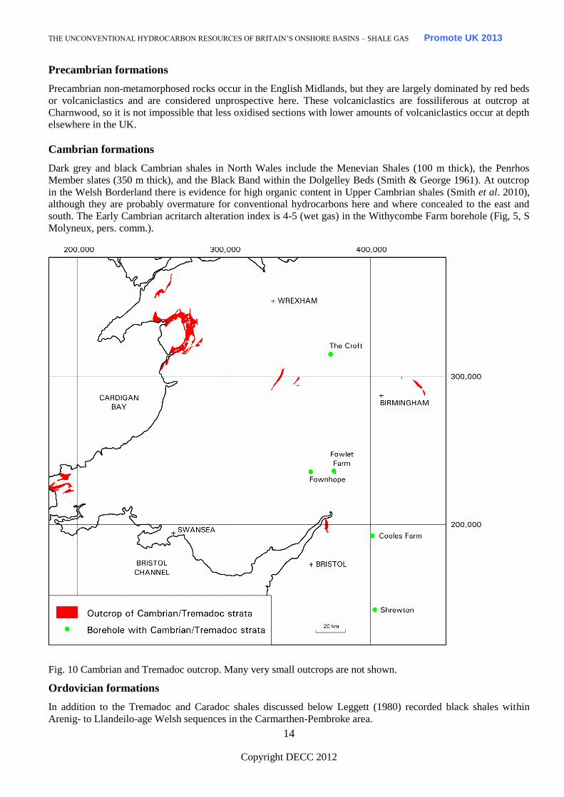
Cambrian formations
Dark grey and black Cambrian shales in North Wales include the Menevian Shales (100 m thick), the Penrhos
Member slates (350 m thick), and the Black Band within the Dolgelley Beds (Smith & George 1961). At outcrop
in the Welsh Borderland there is evidence for high organic content in Upper Cambrian shales (Smith et al. 2010),
although they are probably overmature for conventional hydrocarbons here and where concealed to the east and
south. The Early Cambrian acritarch alteration index is 4-5 (wet gas) in the Withycombe Farm borehole (Fig, 5, S
Molyneux, pers. comm.).
Fig. 10 Cambrian and Tremadoc outcrop. Many very small outcrops are not shown.
Ordovician formations
In addition to the Tremadoc and Caradoc shales discussed below Leggett (1980) recorded black shales within
Arenig- to Llandeilo-age Welsh sequences in the Carmarthen-Pembroke area.
Page 20
THE UNCONVENTIONAL HYDROCARBON RESOURCES OF BRITAIN’S ONSHORE BASINS – SHALE GAS Promote UK 2013
Copyright DECC 2012
15
Tremadoc
Tremadoc shales are widespread and thick on the Midland Microcraton (Smith & Rushton 1993), but are lean
where analysed and without high gamma values where drilled (Smith et al. in press). Tappin & Downie (1978)
recorded dark grey, thinly laminated, cleaved Tremadoc shales in core offshore of Tenby, south Wales, so parts of
the Midland Microcraton and outer Variscides may contain a relatively organic-rich facies.
At outcrop near Merevale in central England and in well samples at Shrewton in the Wessex Basin (Fig. 5),
Tremadoc shales have a maturity of 1.3-2.6 VR% equivalent (Smith 1993). Equivalent shales are also present in the
outer Variscan zones under the Weald and Wessex basins (Smith 1985). In the Shrewton well between 1,743 and
2,073 m depth, these shales have poor TOC values (0.20-0.38 %). Underlying Cambrian shales may be a potential
target at the southern end of the Palaeozoic Worcester Graben.
Tremadoc gas shows
Calvert well in Buckinghamshire (Fig. 5) discovered gas in 1911 over a 13.3 m interval in probable Tremadoc-age
non-black strata. Although the well was deepened and another well drilled farther east, there were no further signs
of gas. The gas composition was reported to be high in nitrogen and in ethane, though this may be incorrect.
Another sub-economic gasfield was found by BP to the north at Twyford (Fig. 5) in porous Late Triassic, Penarth
Group strata directly overlying Tremadoc shales. This gas also had high nitrogen content, but no ethane.
Brunstrom (1966) and Oswald (1996) noted the presence of helium in this gas. The most likely source for the gas
may be Westphalian strata in Oxfordshire to the west, rather than from Tremadoc shales. Helium and nitrogen do
not rule out a coal source, although high ethane values are relatively unusual for a coal source.
Caradoc
The Caradoc-age Nod Glas Formation and underlying beds of N Wales are up to 400 m thick and contain jet-black
shales (Smith & George 1961). Equivalent Caradoc black shales lie unconformably on Precambrian strata in
Shropshire, indicating a transgression which penetrated at least the NW margin of the Midland Microcraton. This
is the only post-Tremadoc-age Ordovician interval to be present on the Midland Microcraton (Smith 1987).
Ordovician to Silurian formations
The lead mine at Van in mid Wales (Fig. 11) encountered methane, water and hydrogen sulphide in Ashgill- and
Llandovery-age mudstones, beginning about the year 1865 and culminating in an explosion in 1908 (Hughes
1991).
Silurian formations
Silurian shales appear to be lean on the Midland Microcraton, based on their geophysical log character. Surface or
subsurface geochemical sampling is needed here. Silurian samples on the margin of the Weald Basin gave low
TOC, P1 and P2 yields. Graptolite reflectance and conodont alteration indices suggest oil window maturity in the
Welsh Borderland and higher maturity in the Welsh Basin. Velocity data (used as a proxy for maturity) suggest a
similar pattern for Silurian shales in the East Anglian Caledonides.
Leggett (1980, Fig. 11) illustrated the distribution of hemi-pelagic black Llandovery-age (Early Silurian) shales in
central Wales. The graptolitic basin facies of the Ludlow (Late Silurian) in the Clun Forest area may have some
shale gas potential (Earp & Hains 1971, fig. 35) – most of this sequence is described as grey in colour, with
slumped and turbiditic beds. None of the Silurian basin facies rocks have been drilled or logged except at Glan
Fred (Fig. 5).
Page 21
THE UNCONVENTIONAL HYDROCARBON RESOURCES OF BRITAIN’S ONSHORE BASINS – SHALE GAS Promote UK 2013
Copyright DECC 2012
16
10 km
Fig. 11 Silurian hemi-pelagic mudstones in Wales. NB Abrupt terminations reveal areas where not mapped in
detail. Red dot signifies gas shows at the Van lead mine, black squares indicate springs with hydrogen sulphide.
Devonian formations
Orcadian Basin
Lower and Middle Devonian clastic sediments unconformably overlie metamorphic basement in the Orcadian
Basin (northern Scotland) of Caithness, Orkney and Shetland islands. The Middle Devonian sediments include 180
m of rich, mature lacustrine source rocks (Eday Marls), which accumulated in Lake Orcadie. These have been
thoroughly studied because various geochemical data suggest their source rocks have contributed to fill of the
Beatrice Oilfield (Bailey et al. 1990).
In Orkney the average TOC of the Devonian is 1.4% (Marshall et al. 1985). Within this succession the Lower
Stromness Flagstones have TOC values over 6%, whereas the Sandwick Fish Bed (20 m thick) and Upper
Stromness Flagstones have an average TOC of 2.3%. A Permanent Lake facies occurs in cycles about 1.5 m thick,
repeated 108 times. The potential source rock is therefore dispersed between less promising sediment within a total
thickness of over 800 m. The organic matter is Type II, derived from cellulose of land plants. However, the
Devonian strata here are only marginally mature for oil generation in Orkney (Hillier & Marshall 1992) and are
hence unprospective for shale gas.
Towards the centre of the Orcadian Basin, the Devonian sequence exceeds 4,000 m in thickness. Based on
offshore data, this sequence may locally include significant thicknesses of Lower Devonian lacustrine shales, with
possible shale gas potential.
Page 22
THE UNCONVENTIONAL HYDROCARBON RESOURCES OF BRITAIN’S ONSHORE BASINS – SHALE GAS Promote UK 2013
Copyright DECC 2012
17
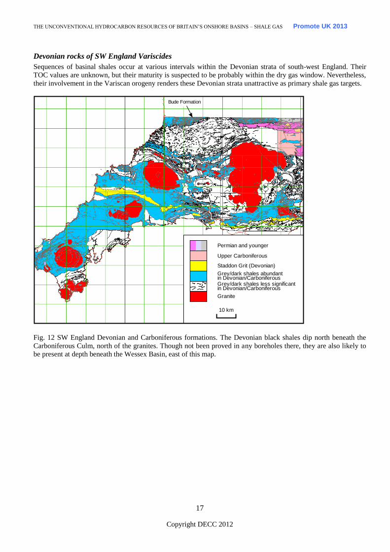
Devonian rocks of SW England Variscides
Sequences of basinal shales occur at various intervals within the Devonian strata of south-west England. Their
TOC values are unknown, but their maturity is suspected to be probably within the dry gas window. Nevertheless,
their involvement in the Variscan orogeny renders these Devonian strata unattractive as primary shale gas targets.
Bude Formation
Granite
Grey/dark shales less significantin Devonian/Carboniferous
Grey/dark shales abundantin Devonian/Carboniferous
Staddon Grit (Devonian)
Upper Carboniferous
Permian and younger
10 km
Fig. 12 SW England Devonian and Carboniferous formations. The Devonian black shales dip north beneath the
Carboniferous Culm, north of the granites. Though not been proved in any boreholes there, they are also likely to
be present at depth beneath the Wessex Basin, east of this map.
Page 23
THE UNCONVENTIONAL HYDROCARBON RESOURCES OF BRITAIN’S ONSHORE BASINS – SHALE GAS Promote UK 2013
Copyright DECC 2012
18
4. Shale gas prospectivity – UK Carboniferous to Triassic shale
formations
Lower Carboniferous shale formations
Early Carboniferous Strathclyde Group: former Oil-Shale Group of Scottish Midland Valley (West
Lothian)
Several oil-shale intervals in a 670 m sequence within the Strathclyde Group were extensively worked for
hydrocarbons between the years 1850-1962 (e.g. Carruthers et al. 1927). These source rocks are immature for oil
at crop in the oil-shale fields, but they display free oil adjacent to sill intrusions that have increased their maturity.
An interval termed Houston Marls tested 330 mcfd gas in BP Salsburgh 1A well (Fig. 5) at about 850 m downhole.
Unfortunately the well was not logged to TD so the identification of oil-shales in the well was derived only from
cuttings.
Tournaisian Lower Limestone Shale (now Avon Group)
Occupying the South Wales Variscan foreland basin, the earliest Carboniferous Lower Limestone Shale may have
some shale gas potential. It is generally black in South Wales, but at Cannington Park borehole south of Bristol
Channel (Fig. 13) it comprises dark grey mudstones interbedded with thin limestones. In this borehole it is
tectonised, with steep dips, overturned, much fractured and veined and is hence probably non-prospective. Total
organic carbon data is needed for the less tectonised South Wales sequence, but the vitrinite reflectance is high
(over 3.5%). The same formation evidently extends eastwards beneath the Weald Basin, but detailed sampling has
only been made at Warlingham borehole (Fig. 5), where the formation is 34 m thick and consists of dolomitic
siltstone and dark grey shelly mudstones (Worssam & Ivimey-Cook 1971).
Topmost Dinantian Upper Limestone Shales (Oystermouth Formation) to Early Namurian Marros
Group (lower part)
Together equivalent to the Lower and Upper Bowland Shales of the Pennine Basin, these formations of the South
Wales-Bristol Basin offer high gamma shales, but are interbedded with thick sandstones and underlain by
limestones in Maesteg borehole (Fig. 5). In Ashton Park borehole (Fig. 5) thin high gamma ray shales, with pyrite,
phosphates, fish debris, cherts and a marine fauna are present, interbedded with sandstones. If these shales thicken
to the south, which is likely, and maintain their high gamma ray characteristic they could provide a realistic shale
gas target.
Although perhaps having no relevance to shale gas prospectivity, the tectonic morphology of the South Wales-
Bristol Basin (Fig. 13) is remarkably similar to, but much smaller than the Fort Worth Basin (USA) containing the
Barnett Shale. Both are foreland basins, with aulacogens intervening perpendicular to an adjacent fold belt (Smith
et al. in press). However, the UK’s Lower Carboniferous shales rest conformably on Upper Devonian strata,
whereas the Barnett Shale lies unconformably on Lower Palaeozoic rocks. The South Wales-Bristol Basin thickens
toward the fold belt, whereas the Barnett Shale thickens towards the aulacogen.
Page 24
THE UNCONVENTIONAL HYDROCARBON RESOURCES OF BRITAIN’S ONSHORE BASINS – SHALE GAS Promote UK 2013
Copyright DECC 2012
19
Namurian to Lower Westphalian
Devonian undifferentiated
Upper Westphalian
Lower Devonian
Lower Carboniferous (limestone)
Silurian
Tremadoc and Cambrian
Precambrian
Upper Devonian
Silurian volcanics
Bristol - Somerset
BasinBath
10 km
Fig 13 Bristol-Somerset Basin, wedged between Variscan Front thrust (to south) and Worcester Uplift. The
Variscan Front bisects the Bristol Coalfield near Bath and affects the southern end of the Worcester Uplift.
Carboniferous of Pennine Basin – Lower Bowland Shale (Widmerpool Formation, Worston Shale,
Arundian Shale etc of Dinantian age)
Dinantian shales are often present on upstanding structural blocks in northern England (e.g. Rossendale) as thin
developments within a largely limestone sequence, but they expand considerably into adjacent half graben sub-
basins of the Pennine Basin (Kirby et al. 2000, Smith et al. 2005). These shales do not have the high gamma
signature of, and are hence less prospective than, the overlying Upper Bowland Shale.
Carboniferous of Pennine Basin – Upper Bowland Shale of early Namurian age
The Early Namurian shale units (local names Bowland, Edale, Holywell shales, top part of Craven Group) of the
Pennine Basin offer the best potential for shale gas exploration in the UK because they have sourced
hydrocarbons, and have high TOCs (Armstrong et al. 1997). These shales are more widespread than the Dinantian-
aged shales, because they were deposited as the extensional half graben subsidence was transforming to a more
regional thermal subsidence.
Upper Bowland Shale (Namurian)
Upper Bowland Shale – Total Organic Carbon (TOC)
Namurian marine shales have generally higher TOC values (over 4%) compared to non-marine shales (Spears &
Amin 1981), which have an average value of around 2% (Fig. 14).
Page 25
THE UNCONVENTIONAL HYDROCARBON RESOURCES OF BRITAIN’S ONSHORE BASINS – SHALE GAS Promote UK 2013
Copyright DECC 2012
20
F
ig. 14 Variation of TOC contents in Carboniferous boreholes from northern England. Gleaston borehole is in south
Cumbria; Ferneyrigg, Stonehaugh and Marshall Meadows are in the Northumberland Trough, Roddymoor is on
the Alston Block, Beckermonds is on the Askrigg Block, and all other boreholes are in the Pennine Basin.
Maynard et al. (1991) found that two thin Namurian black shale marine bands had a TOC content of between 10-
13%, whereas values within interbedded strata ranged between 2 and 3%. The Namurian Holywell Shale, source
rock for the southern East Irish Sea gas and oil fields and Formby oil field, has TOC values ranging from 0.7-5%,
with an average of 2.1% (Armstrong et al. 1997). The lower part of this formation has an average of 3% TOC with
pyrolsate yields of 7 kg/tonne –1
. These values are comparable with producing US gas shales.
Craven Group (including Upper Bowland Shale) – Thermal Maturity
There is no agreement on the lower limit of maturity for gas generation, which has variously been put at 2% Ro
(Landes 1967), 3% Ro (Dow 1977), 3.2% Ro (Dow & Connor 1982) and 5% Ro (Hood et al 1975). In this study a
value of 1.1% Ro has been used to differentiate maturity levels above and below the gas window (Fig. 15), because
this value defines the maturity limit for the Barnett Shale in the American Newark East gasfield (Pollastro et al.
2004). A number of papers now put the floor for shale gas prospectivity at Ro 3.5%, and it will be interesting to see
if this theoretical limit is tested in any of the developing plays worldwide.
Vitrinite reflectance (%Ro) measurements at outcrop and in boreholes provide a widely accepted proxy for thermal
maturity and hydrocarbon generation. These are shown for the nearest value analysed to the basal Namurian (Fig.
15). The orange and red symbols show boreholes drilled in sub-basins where the gas window is present (Cheshire
Basin SE of Milton Green, Gainsborough 2 in Gainsborough Trough. A vast area with no data probably also lies in
the gas window, for example between Trumfleet and Weeton (Fig. 5) and in the subsurface of the Craven Basin
and its adjacent West Lancashire Basin. The Widmerpool Gulf is defined by the white area SW of Duffield (Fig.
15), where there is no drilling. Duffield borehole (Fig. 5) lies within the oil window but lies north of the basin
depocentre. Most of the Cleveland Basin is within the gas window, with the southern line of gas fields (e.g. Kirby
Misperton) at a lower level of maturity on the crests of structures. The large area to the south of these fields has
thick, subcropping Coal Measures (Smith 1985), with no deep wells, but is probably also within the gas window.
Page 26
THE UNCONVENTIONAL HYDROCARBON RESOURCES OF BRITAIN’S ONSHORE BASINS – SHALE GAS Promote UK 2013
Copyright DECC 2012
21
Fig. 15 Maturity of wells in Pennine Basin (see text for details)
Duffield borehole
0
200
400
600
800
1000
1200
0 1 2 3 4 5 6 7
Total organic carbon
Dep
th (
m)
Namurian
Dinantian
VR %
Fig. 16 Range of total organic carbon contents and vitrinite reflectance in the BGS Duffield borehole, Widmerpool
Gulf (Fig. 5). The high VR% near the base of the borehole is caused by proximity to igneous sills – these may lead
to gas window maturity near or below terminal depth.
Craven Group (including Upper Bowland Shale) – Porosity, Permeability and Fracture Porosity
There is no porosity data available for Pennine Basin Namurian shales. From BGS boreholes in the southern
Midlands, porosities of 5-10% appear to survive to depths of over 900 m in Upper Palaeozoic shales (Poole 1977,
Page 27
THE UNCONVENTIONAL HYDROCARBON RESOURCES OF BRITAIN’S ONSHORE BASINS – SHALE GAS Promote UK 2013
Copyright DECC 2012
22
1978). Upper Carboniferous Coal Measures mudstones, seat-earths and siltstones have measured permeability
values in the range 4.34 x 10⁻⁶
to 7.1 x 10⁻³
mD (Oldroyd et al. 1971).
Joints, developed in the limestone platforms of Derbyshire and the Askrigg Block (Moseley & Ahmed 1967), are
predominantly sub-vertical and perpendicular to bedding. Joint development preceded the main phase of
movement on the main fault zones and they are frequently mineralized. Well-bedded marine shales between these
limestones tend to have a high joint density, in contrast to mudstones and sand-rich shale units. Minor joints are
more difficult to distinguish in argillaceous rocks, but master joints persist strongly with a high fracture density
(0.6-3 m spacing).
The predominant NW trend of the main Carboniferous joint sets is coincident with the present day maximum
horizontal stress direction (145/325o, Evans & Brereton 1990). Rogers (2003) predicted that the stress-induced
fracture permeability is likely to be highest along this trend in the current UK stress field.
Craven Group – Mineralogy
The Al2O3 content of UK Carboniferous mudstones ranges between 12-38%, with an average of around 25%
(Ramsbottom et al. 1981). Marine and non-marine shales in the Tansley borehole (Fig. 5) have average Al2O3
contents of 20.6% and 17.9% respectively, with clay minerals making up 59% and 56% of the shale matrix (Spears
& Amin 1981). The Barnett Shale has a relatively low clay content (c. 27%, Jarvie et al. 2004) compared to other
gas shales. The presence of significant amounts of quartz (45%) and carbonate (10%) in the shale matrix, imparts
brittleness to the rock, facilitating artificial fracturing.
Craven Group – Associated Gas Fields and Discoveries
The presence of conventional gas fields in UK Carboniferous basins (Fig. 4) demonstrates that gas has been
generated. In a few cases there is unambiguous evidence of the source being Namurian shales (e.g. the Elswick
Gasfield in the West Lancashire Basin, Fig. 3), because Coal Measures are absent in the subcrop (Smith 1985). In
some gas fields migration could have occurred from either a Coal Measures source or from Namurian strata
uplifted in an inverted basin (e.g. Nooks Farm, Fig. 5). Along the southern margin of the Cleveland Basin
(Marishes to Malton gas fields, Fig. 4) migration along E-W faults from the Southern North Sea, is also a
possibility.
Gas wetness (percentage of non-methane gas) values (Smith et al. in press, fig. 10) are high when gas is associated
with oil in the source rock, and lower (<5%) when the gas has been exclusively derived from coal-rich strata or is
biogenic or overmature. Jarvie et al. (2004) typified two gas samples in the Barnett Shale as overmature dry gas,
with gas wetness values of around 5%; in contrast oil associated gas had values over 12%. In the Carboniferous of
the UK, high gas wetness values measured at Welbeck Colliery are associated with oil shows, but at nearby
Thoresby Colliery (also associated with oil) the gas is rich in methane and was probably sourced from the Coal
Measures (Challinor 1990).
In most UK gas fields there are insufficient gas composition and carbon isotope data available to resolve the
migration directions. Carbon and hydrogen isotope data from methane samples accompanying water flows within
Wyresdale Tunnel (Fig. 15, the methane caused the Abbeystead explosion in 1985) in Namurian strata (Smith et
al. in press, fig. 7) suggest that the gas either had a modern biogenic origin or formed through CO2 reduction. The
US Antrim Shale and New Albany Shale (Smith et al. in press, fig. 7, Illinois Quaternary-hosted gas) have late
generation biogenic gas systems related to glacial meltwater ingress via fractures (Schurr & Ridgley 2002). US
exploration has used stable isotopes to confirm source, maturity and hydrocarbon generation zone. In the UK we
need to apply these methods to resolve the source of already discovered fields and shows.
Wherever present, the Upper Bowland Shale is an attractive prospect because high gamma shales are present
together with other shale-dominated facies. The gross thickness of the formation ranges from 0-300 m (Fig. 17).
The organic rich, net thickness is defined by gamma values greater than 180 API and ranges between 0-110 m
thickness. Other shales need to be mapped in the same way, in the overlying Namurian and underlying Dinantian
successions. The Dinantian half graben basins (Fraser et al. 1990, Fig. 18) indicate the areas where basin-centred
prospects exist.
Page 28
THE UNCONVENTIONAL HYDROCARBON RESOURCES OF BRITAIN’S ONSHORE BASINS – SHALE GAS Promote UK 2013
Copyright DECC 2012
23
Fig. 17 Gross thickness, and thickness of high gamma facies in the Upper Bowland Shale (Namurian part only).
Black circles show gross thickness (metres) and coloured circles show thickness of high gamma shales in metres.
In their written evidence to the ECC Select Committee Shale Gas Inquiry, IGAS reported the results of their
2010, Equipoise Solutions Ltd independent review of the shale gas potential of Holywell shale within the Point of
Ayr license. “This is spread across the North West of England (predominantly Cheshire) and North Wales (off the
coast to the north of Rhyl and Prestatyn). Estimates of GIIP aggregated over all of these interests indicate a low net
total of 31 bcf shale gas, a middle net total of 412 bcf shale gas and a high net total of 1,945 bcf shale gas. These
values assume that the Holywell shale is normally pressured. There is a possibility that part of the Holywell shale
is actually over-pressured (although the company currently has no evidence of this). This would mean much higher
gas content and higher initial production rates in those areas.” A subsequent report on their website on 23 May
2011 gave their entire shale gas portfolio an estimated range of gas in place as 89Bcf - 1,139Bcf - 4,644bcf.
In February 2011 Dart Europe took over Composite’s acreage and announced that they estimated approximately
1.22 trillion cubic feet of shale gas in place on their blocks.
On 21 September 2011 Cuadrilla announced that they estimate there to be some 200 trillion cubic feet of shale gas
in place within the licence area they have been exploring in Lancashire.
Page 29
THE UNCONVENTIONAL HYDROCARBON RESOURCES OF BRITAIN’S ONSHORE BASINS – SHALE GAS Promote UK 2013
Copyright DECC 2012
24
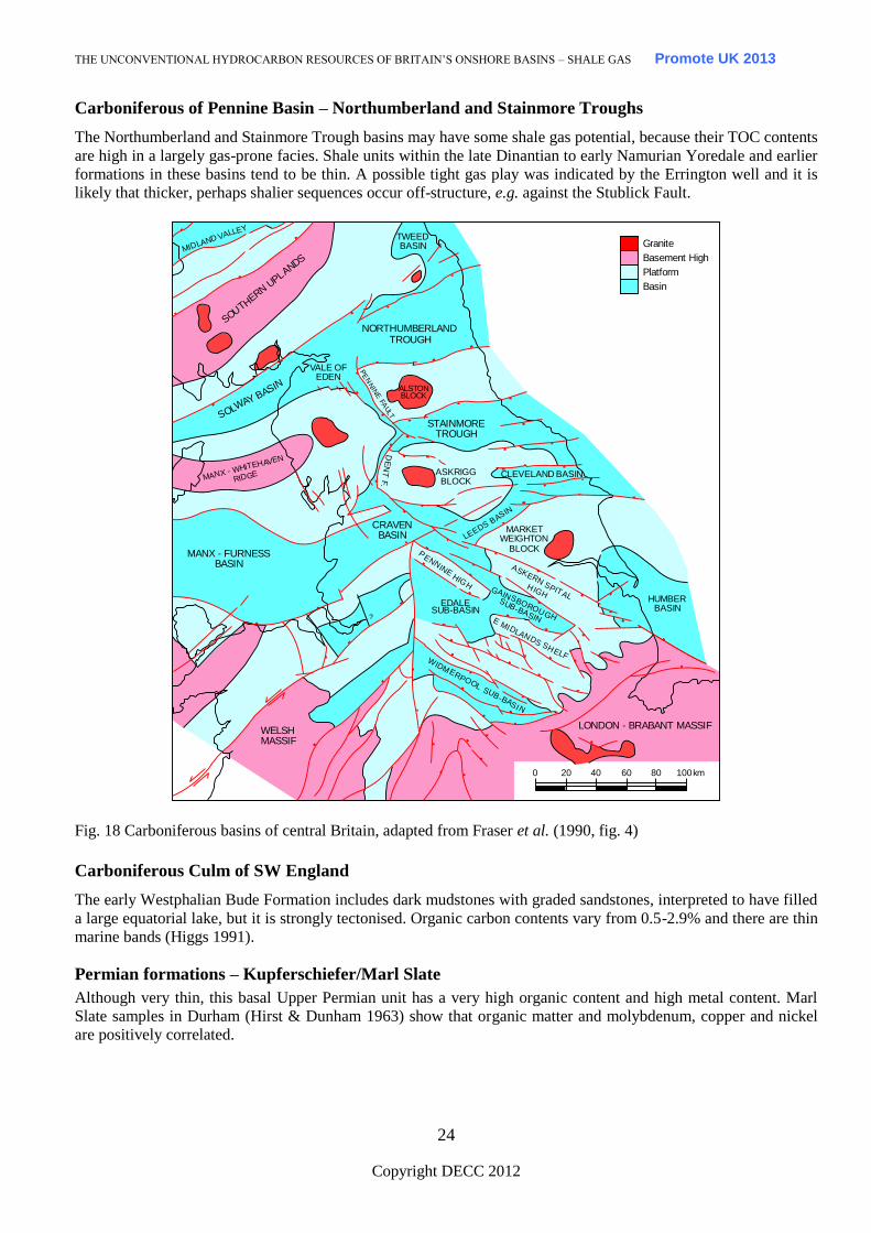
Carboniferous of Pennine Basin – Northumberland and Stainmore Troughs
The Northumberland and Stainmore Trough basins may have some shale gas potential, because their TOC contents
are high in a largely gas-prone facies. Shale units within the late Dinantian to early Namurian Yoredale and earlier
formations in these basins tend to be thin. A possible tight gas play was indicated by the Errington well and it is
likely that thicker, perhaps shalier sequences occur off-structure, e.g. against the Stublick Fault.
Granite
Basement High
Platform
Basin
ASKRIGGBLOCKMANX - W
HITEHAVEN
RIDGE
SOLWAY BASIN
MIDLAND VALLEY
SOUTH
ERN UPLANDS
DE
NT
F.
CLEVELAND BASIN
PE
NN
INE
FAU
LT
LEEDS BASIN
MARKETWEIGHTON
BLOCK
HUMBERBASIN
ASKERN SPITALHIGH
GAINSBOROUGH
SUB-BASINE MIDLANDS SHELF
EDALESUB-BASIN
WELSH MASSIF
WIDMERPOOL SUB-BASIN
LONDON - BRABANT MASSIF
0 20 40 60 80 100 km
PENN
INE HIGH
CRAVENBASIN
MANX - FURNESSBASIN
STAINMORETROUGH
NORTHUMBERLANDTROUGH
TWEEDBASIN
ALSTONBLOCK
VALE OFEDEN
?
Fig. 18 Carboniferous basins of central Britain, adapted from Fraser et al. (1990, fig. 4)
Carboniferous Culm of SW England
The early Westphalian Bude Formation includes dark mudstones with graded sandstones, interpreted to have filled
a large equatorial lake, but it is strongly tectonised. Organic carbon contents vary from 0.5-2.9% and there are thin
marine bands (Higgs 1991).
Permian formations – Kupferschiefer/Marl Slate
Although very thin, this basal Upper Permian unit has a very high organic content and high metal content. Marl
Slate samples in Durham (Hirst & Dunham 1963) show that organic matter and molybdenum, copper and nickel
are positively correlated.
Page 30
THE UNCONVENTIONAL HYDROCARBON RESOURCES OF BRITAIN’S ONSHORE BASINS – SHALE GAS Promote UK 2013
Copyright DECC 2012
25
Triassic formations
Almost all UK Triassic formations are strongly oxidised. The Westbury Formation in the uppermost Triassic
Penarth Group is a black shale that might have some potential if it weren’t immature for oil, even in the Bristol
Channel margins (Macquaker et al. 1986).
5. Shale gas prospectivity – UK Jurassic shale formations
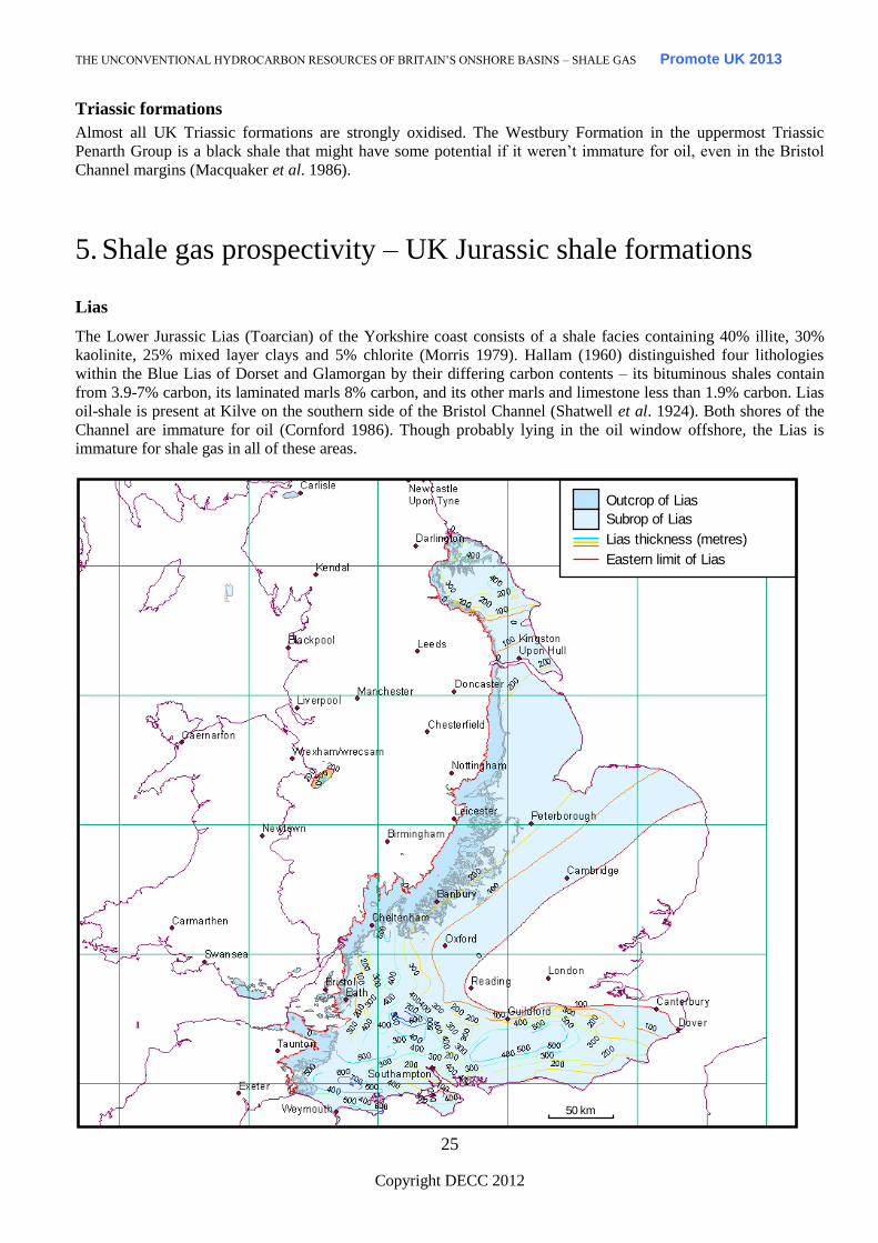
Lias
The Lower Jurassic Lias (Toarcian) of the Yorkshire coast consists of a shale facies containing 40% illite, 30%
kaolinite, 25% mixed layer clays and 5% chlorite (Morris 1979). Hallam (1960) distinguished four lithologies
within the Blue Lias of Dorset and Glamorgan by their differing carbon contents – its bituminous shales contain
from 3.9-7% carbon, its laminated marls 8% carbon, and its other marls and limestone less than 1.9% carbon. Lias
oil-shale is present at Kilve on the southern side of the Bristol Channel (Shatwell et al. 1924). Both shores of the
Channel are immature for oil (Cornford 1986). Though probably lying in the oil window offshore, the Lias is
immature for shale gas in all of these areas.
Outcrop of Lias
Lias thickness (metres)
Subrop of Lias
Eastern limit of Lias
50 km
Page 31
THE UNCONVENTIONAL HYDROCARBON RESOURCES OF BRITAIN’S ONSHORE BASINS – SHALE GAS Promote UK 2013
Copyright DECC 2012
26
Fig. 19 Outcrop and subcrop and thickness in metres of the Lias in eastern Britain
The Lias is the source rock for the Weald Basin petroleum system and for the Wessex Basin (Ebukanson &
Kinghorn 1986), with migration into 3 different reservoirs in Wytch Farm oil field. Colter & Havard (1981)
deduced that the Lias in the Arreton 2 well (Fig. 5) does not show a high gamma profile, and the sampled TOCs
are low. The well lies about 50 km east of the probable source of oil at Wytch Farm.
Maturity is low on the former tilt-block highs on the footwall to the syn-sedimentary faults in the Weald and
Wessex Basins. In the Cleveland Basin the Lias is within the oil window and there are extensive oil shows but no
gas in its iron-ore mines.
In Godley Bridge 1 well (Fig. 5) the Lias downhole gas readings are fairly low, whereas the overlying Fuller’s
Earth had higher values.
Fuller’s Earth
TOC values are good (up to 3.48%) within the Fuller’s Earth in the Weald Basin, but it has only reached oil
window maturity in the basin’s depocentre.
Oxford Clay
Overlying the Great Oolite Group oil reservoir in the Weald Basin, the Oxford Clay is affected by late Cimmerian
erosion (Fig. 20) on the tilt block highs, but thickens towards syn-sedimentary faults controlling the half graben
within the basins. The Oxford Clay is immature for hydrocarbon generation in the English Midlands, but it is
significantly organic-rich to be self-firing in the Fletton brick-making process (Gallois 1979). In the Weald Basin
its TOC reaches 7.83% and it lies within the oil window at the basin’s depocentre. In southern England and central
England there is often a bituminous horizon near the base, but this is absent in Yorkshire (Duff 1975). TOCs
average below 2% in the non-bituminous sections but are over 4% in most of the bituminous sections of central
England (Duff 1975), where they are immature for oil.
Page 32
THE UNCONVENTIONAL HYDROCARBON RESOURCES OF BRITAIN’S ONSHORE BASINS – SHALE GAS Promote UK 2013
Copyright DECC 2012
27
Outcrop of Oxford Clay
Eastern limit of Oxford Clay
50 km
Oxford Clay thickness (metres)
Fig. 20 Oxford Clay outcrop and isopachs in metres (from Whittaker 1985)
Shelly horizons within the Oxford Clay contain free oil in the Wytch Farm Oilfield (Colter & Havard 1981), but
this might represent migrated oil.
Kimmeridge Clay
The Kimmeridge Clay Formation of onshore eastern and southern England (Fig. 21) is a potentially prospective
shale (for oil and probably biogenic gas) because it contains ubiquitous oil-shale beds (Gallois 1979). Its
background shale has TOC up to about 10%, its bituminous shale has TOC values up to 30% and its oil-shales
have TOCs reaching 70% (e.g. the Blackstone Bed, Stocks & Lawrence 1990). Five basins show thickening of the
formation in response to syn-sedimentary faulting (Weald, Wessex, English Channel, Cleveland and Lincolnshire-
Norfolk).
Page 33
THE UNCONVENTIONAL HYDROCARBON RESOURCES OF BRITAIN’S ONSHORE BASINS – SHALE GAS Promote UK 2013
Copyright DECC 2012
28
Outcrop of Kimmeridge Clay
Thickness of Kimmeridge Clay (metres)
0 - 200
200 - 400
400 - 600
> 600
Normal fault
50 km
Fig. 21 Kimmeridge Clay outcrop and subcrop. The Kimmeridge Clay is immature in south-east England.
Nevertheless it is associated with oil and gas shows, indicating a probable biogenic gas play. Oil-shales have been
worked and assessed in Dorset and Norfolk-Lincolnshire. The isopachs are from Whittaker (1985).
The Kimmeridge Clay Formation is immature for thermogenic gas generation onshore (Scotchman 1991) and it is
only marginally mature for oil generation in the Weald Basin depocentre. Its carbonate content varies from 12%
(oil-shales) to 94% (limestones, Farrimond et al. 1984). Scotchman (1991) showed that high TOCs and
sedimentation rate result in high phytane/TOC values. The low maturity is confirmed by TMAX 403-437 °C on
pyrolysis. Samples confirmed kerogen of Type II or mixed Type II-III on the Van Krevelen diagram (Tissot et al
1974).
Exploration for oil-shale deposits was conducted in Dorset at Corton after World War 1 (Strahan 1920). Similarly,
English Oilfields Ltd and the Norfolk Oil Shale Syndicate drilled about 50 wells in an attempt to develop a mining
operation on an immature source rock in Norfolk at West Winch and Setch (Fig. 5), with over-optimistic
shareholder information becoming confused with scientific statements (Forbes-Leslie 1917a, 1920).
Key stratigraphic boreholes (Swanworth and Metherhills, Fig. 5) were drilled in the Wessex Basin for research
purposes (Taylor et al. 2001). The sediments encountered are immature for oil generation, with VR values < 0.4%.
After the first OPEC oil price increase of 1973, twelve additional wells were drilled along the Kimmeridge Clay
outcrop of eastern-southern England to assess the thickness, extent and composition of the oil-shales. These wells
showed a very condensed section near to the London-Brabant Massif from NE of Swindon to Cambridge (Fig. 21)
where the oil-shales are replaced by mudstones and the remaining beds are very thin. Near Swindon a sandy facies
is present (Gallois 1979).
Exploitation of these Kimmeridge Clay oil-shale beds was uneconomic because of the thinness of the beds and
high sulphur content. This may be overcome by horizontal drilling, and future exploration could be a combination
of coal bed methane-type exploration (in relatively thin oil-shale beds), and shale gas exploration in the formation
Page 34
THE UNCONVENTIONAL HYDROCARBON RESOURCES OF BRITAIN’S ONSHORE BASINS – SHALE GAS Promote UK 2013
Copyright DECC 2012
29
as a whole. The English Channel Basin, particularly south of Purbeck and on the southern Isle of Wight, contains
more mature source rocks at all levels than in the area near Wytch Farm oil field (Colter & Havard 1981), because
of Alpine inversion.. There are already precedents for deviating wells from the onshore to the offshore (Amoco’s
Down Barn (Fig. 5) and the Wytch Farm development wells in Dorset) to access the main part of the basin for
shale gas.
Kimmeridge Clay – gas shows
Shows of oil and gas were detected in several Weald Basin wells, including Sub-Wealden 1 & 2 (Fig. 5, Pearson
1904). The gas has migrated into reservoir beds (Corallian, Portland, Purbeck and Wealden), but its source is
probably Kimmeridge Clay or Purbeck Shales. The gas in the Heathfield wells (Fig. 5) is at various horizons, some
sandy but others in thin limestones and shale. As the deeper Lias shales are probably within the oil window at
depth here the gas, although relatively wet, is probably biogenic. It is probably not of post-Pleistocene age related
to bacteria-carrying meltwater, as in the Antrim Shale of USA, but it has begun migrating since the Alpine
anticlines were formed in Miocene times. Southard Quarry well (Fig. 5) discovered gas in an inversion anticline,
near to an offshore gas seep at Anvil Point and in well 98/11-2.
Kimmeridge Clay – gas fields
Small gas fields and gas discoveries occur in a line along the northern Weald Basin (Albury, Bletchingley,
Lingfield and Cowden), with Godley Bridge, Baxter’s Copse and Heathfield fields in the centre and south of the
basin (Fig. 5). The Heathfield gas has been used to light its railway station since 1899, producing about 20 mmcf.
Kimmeridge Clay – gas composition
Conventional gas exploration has distinguished between gas associated (with oil) and non-associated gas, the latter
deriving mostly from coal-bearing formations. Non-associated gas is characterised as a dry gas (low gas wetness)
according to Gadon (1987), but the gas wetness variability (e.g. Southern North Sea Hewett Field gas, assumed to
be derived from coals) seems to overlap with associated gas wetness values. Some obvious coal-derived gases do
show low gas wetness and it may be that a significant component of Southern North Sea gas is not derived from
coal (Lokhurst 1998). This leaves a problem attributing the source to some of the onshore gases discovered. They
might have potential for shale gas prospects if it could be shown that they were not derived from coal, but the gas
compositional evidence is ambiguous. Many fields and discoveries lie between a coal source on one side and an
inverted shale basin on the other side (e. g. Nooks Farm, Ryedale fields of southern Cleveland Basin and Cousland
in East Lothian). The Weald Basin wet gases confirm a non-coal source but do not discriminate between other
types of source (biogenic or thermogenic). From the work of Scotchman (1991) and others the Kimmeridge Clay is
shown to be immature for oil onshore. Therefore the many gas shows within the Kimmeridge Clay or probably
derived from it must be biogenic (e.g. Heathfield). Unfortunately there are no stable carbon isotopic analyses
available in the public domain to confirm this.
Purbeck
There is also a Purbeck oil-shale (Pearson 1904), at outcrop in the Purbeck Inlier on the Wealden Anticline in
Sussex.
Resource Estimate
Celtique Energie currently have an estimate on their website for their Weald acreage of mean recoverable shale oil
and shale gas resources are estimated at c. 125 mmbbl of oil and c. 10 tcf of gas, respectively. They go on to say
that “shale gas deposits are expected to yield wet gas, with significant quantities of condensate. The seismic data
and maturity modelling studies for the Weald basin also suggest that 2 shale gas resources may be located in the
centre of the Weald Basin. The area of Liassic source rock within the gas window is believed to be over 467
sq.kms (115,000 acres) at exploitable drilling depths between 9,000 and 13,000 feet true vertical depth. Based on
both volumetric analogy to typical US shale gas plays and by a pyrolysis method using S2 values, it is estimated
that the recoverable shale gas potential of the acreage could be as high as 14 tcf, with a mid-case estimate of 10 tcf
plus condensate.”
Page 35
THE UNCONVENTIONAL HYDROCARBON RESOURCES OF BRITAIN’S ONSHORE BASINS – SHALE GAS Promote UK 2013
Copyright DECC 2012
30
6. Environmental concerns
Shale gas production in the US has become controversial because of reports of environmental problems,
particularly contamination of drinking water. However, the evidence seems to show that where the problems are
genuinely attributable to shale gas operations, the problem is with poor well design and construction, rather than
anything distinctive to shale gas. In the UK, well design and construction is addressed by the Health and Safety
Executive through specific regulatory controls, which among other things require verification of the well design by
an independent third party.
Water use and disposal of recovered fluids are also of concern. Re-fracturing might be expected to be repeated
every 4-5 years in successful wells. About a third of the water is returned to the surface. It might be possible to re-
use produced water by a recycling process, or to reduce the potential environmental impact by changing the
chemicals added, but at the moment freshwater is needed for the fracturing.
Every shale gas drilling application must go through the local planning application process and before any drilling
occurs proposals must also be scrutinised by the Environment Agency or Scottish Environment Protection Agency
in Scotland to make sure there is no risk to the environment, and in particular to water sources, by the Health and
Safety Executive for safety, and DECC to ensure best use is made of the resources. As part of this process,
operators are required to disclose the content of fracking fluids to the Environment Agency. The HSE then
monitors progress on the well to determine if the Well Operator is conducting his operations as planned. The HSE
are also notified of any unplanned events and if it is deemed necessary, inspections may be undertaken to inspect
specific well operations on site.
Two small earthquakes were experienced near Blackpool (mag 2.3 and 1.5) in April and May 2011 and DECC had
discussions with Cuadrilla, the company carrying out shale gas exploration in that area, and agreed that a pause in
hydraulic fracture operations is appropriate so that a better understanding can be gained of the cause of the seismic
events. A geomechanical study is being undertaken, and DECC and the BGS will review this assessment before
any resumption of hydraulic fracture operations is approved.
In the light of the robust controls in place, outlined above, to protect the environment and ensure safe operation,
DECC see no need for any moratorium on shale gas. This is also the view of the Energy and Climate Change
Select Committee which held an inquiry into shale gas earlier this year and took evidence from Government,
regulators, the British Geological Survey, the oil and gas industry and environmental groups. The committee
concluded that hydraulic fracturing itself does not pose a direct risk to water aquifers, provided that the well-casing
is intact. Rather, that any risks that do arise are related to the integrity of the well, and are no different to issues
encountered when exploring for hydrocarbons in conventional geological formations.
Drilling close to urban areas may pose problems, but horizontal drilling can reduce the footprint. Land use issues
on a smaller scale in the UK were found and solved by BP at Gainsborough Oilfield in 1959, where the field
underlies the nearby village, and at Wareham, Dorset where the oilfield underlies the town. While landowners
have rights to minerals on or under their land, except where legislation has explicitly removed those rights,
successive Acts of Parliament have vested the right to explore for and extract hydrocarbons in the Secretary of
State for Energy and Climate Change. The operator must secure agreement with landowners for access to the land
concerned, likely resulting in a payment to the landowner, but the landowner has no entitlement to share in any
part of the revenues that the operator wins from his operations. Finding broad local support for shale gas
exploration and development may prove difficult, even with the promise of jobs and benefit to the local economy.
7. Shale oil
Oil-shales are immature source rocks, which have been mined and retorted to release oil, for example in the
Midland Valley of Scotland. Oil-shales which lie in the oil window, that is, down-dip of the near surface mines
Page 36
THE UNCONVENTIONAL HYDROCARBON RESOURCES OF BRITAIN’S ONSHORE BASINS – SHALE GAS Promote UK 2013
Copyright DECC 2012
31
could have potential for production of shale oil. The shale oil could be accessed by the sort of completion
techniques used to produce shale gas. Cannel coals (from most of the UK’s coalfields) have been used as sources
of oil and gas in industrial plants (Strahan 1920).
Conventional source rocks at oil window maturity could be targeted for shale oil. These source rocks could include
those lying close to the established oilfields in the East Midlands and Wessex-Weald basins (half-graben basins
controlled by syn-sedimentary faults).
Part of the Kimmeridge Bay Oilfield production was said to be derived from fractured Oxford Clay (Evans et al.
1998). Kimmeridge 2 well produced a few barrels on DST from sandstones within the Oxford Clay, so this oil is
unlikely to be indigenous to the Oxford Clay.
Page 37
THE UNCONVENTIONAL HYDROCARBON RESOURCES OF BRITAIN’S ONSHORE BASINS – SHALE GAS Promote UK 2013
Copyright DECC 2012
32
8. Conclusions
Shale gas exploration plays have been described as ‘basin-centred’. This term neatly reflects the difference in
drilling philosophy between conventional and unconventional plays. Conventional plays drill structural highs near
to mature source rocks but unconventional plays need to drill the basin depocentres. For this reason, conventional
hydrocarbon wells are not always useful for shale gas exploration because, having been drilled on highs, source
rocks in the wells are often thin or absent entirely. New wells specifically targeting shale gas are needed tested to
delineate the potential.
Shale gas is currently produced in significant volumes only in the US and that success has raised interest in the UK
potential. The untested shale rock volume in the UK is very large, however, more drilling, fracture stimulating
and production testing is necessary to prove that shale gas development is technically and economically viable.
Even if one assumes that the American shale gas producing analogies are valid, many of the operating conditions
are different in the UK. In the UK, land owners do not own mineral rights, so there is less incentive to support
development, and local authorities must grant planning consent. The US has relatively permissive environmental
regulations, low population densities, tax incentives, existing infrastructure, well developed supply chains and
access to technology. Cumulatively, these factors mean that it is far from certain that the conditions that underpin
shale gas production in North America will be replicable in the UK.
Page 38
THE UNCONVENTIONAL HYDROCARBON RESOURCES OF BRITAIN’S ONSHORE BASINS – SHALE GAS Promote UK 2013
Copyright DECC 2012
33
9. References and Links
ARMSTRONG, J.P., SMITH, J., D’ELIA, V.A. A. & TRUEBLOOD, S.P. 1997. The occurrence and correlation of oils and Namurian
source rocks in the Liverpool Bay-North Wales area. In: Meadows, N.S., Trueblood, S.P., Hardman, M. & Cowan, G. (eds) Petroleum
geology of the Irish Sea and adjacent areas. Geological Society Special Publication 124, 195-211
BAILEY, N.J.L., BURWOOD, R. & HARRIMAN, G.E. 1990. Application of pyrolysate carbon isotope and biomarker technology to
organofacies definition and oil correlation problems in the North Sea basins. Organic Geochemistry 16, 1157-1172.
BOWKER, K. 2002, Recent developments of the Barnett Shale play, Fort Worth Basin, in Law, B.E. and Wilson, M. (eds) Innovative Gas
Exploration Concepts Symposium: Rocky Mountain Association of Geologists and Petroleum Technology Transfer Council, October, 2002.
Denver, CO, 16 pp.
BRUNSTROM, R.G.W. 1966. Indigenous petroleum and natural gas in Britain. Institute of Petroleum, 20, 5-27.
CARRUTHERS, R G., CALDWELL, W., BAILEY, E.M. & CONACHER, H.R.J. 1927. Oil-shales of the Lothians. Memoirs of the
Geological Survey, Scotland. 3rd Edition.
CHALLINOR, P.J. 1990. Oil ingress into mine workings. The Mining Engineer, August 1990, 68-74.
COLTER, V.S. & HAVARD, D.J. 1981. The Wytch Farm Oilfield. In: Petroleum Geology of the Continental shelf of North-West Europe,
494-503.
CORNFORD, C. 1986. The Bristol Channel graben: organic geochemical limits on subsidence and speculation on the origin of inversion.
Proceedings of the Ussher Society, 6, 360-367.
CREEDY, D.P. 1988. Geological controls on the formation and distribution of gas in British coal measure strata. International Journal of
Coal Geology, 10, 1-31
CREEDY, D.P. 1989. Geological sources of methane in relation to surface and underground hazards. Paper 1.4 Methane- facing the
problems. Symposium Nottingham 26-28th September.
CUADRILLA RESOURCES LIMITED. 2009. Preese Hall hydrocarbon exploration site: Section 2 Supporting statement with respect to
Planning application to Lancashire County Council.
CUADRILLA RESOURCES LIMITED. 2010. Seismic interpretation. Appendix B to submission for Planning Permission to West Sussex
County Council.
DOW, W.G. 1977. Kerogen studies and geological interpretations. Journal of Geochemical Exploration, 7, 77-79.
DOW, W.G. & O'CONNOR, D.E. 1982. Kerogen maturity and type by reflected light microscopy applied to petroleum exploration. In:
Staplin, F.L., Dow, W.G., Milner, C.W.D., O'Connor, D.I., Pocock, S.A., Van Gijzel, J.P., Welte, D.H. & Yukler, M.A. (eds), How to
Assess Maturation and Paleotemperatures Short Course No. 7. Society of Economic Paleontologists and Mineralogists, 133–157.
DRAKE, S. 2007. Unconventional gas plays. SPEE 6th Dec. 2007.
DUFF, K.L. 1975. Palaeoecology of a bituminous shale- the Lower Oxford Clay of central England. Paleontology, 18, 443-482.
EARP, J.R. & HAINS, B.A. 1971. The Welsh Borderland. British Regional Geology Memoir of the British Geological Survey.
EBUKANSON, E.J. & KINGHORN, R.R.F. 1986. Oil and gas accumulations and their possible source rocks in southern England. Journal
of Petroleum Geology, 9, 4, 413-428.
EVANS, C.J. & BRERETON, N.R., 1990. In situ crustal stress in the United Kingdom from borehole breakouts. In: Hurst, A., Lovell, M.A.,
and Morton, A.C.,( eds)., Geological applications of wireline logs: Geological Society of London Special Publication, 48, 327-338.
EVANS, J., JENKINS, D, & GLUYAS, J. 1998. The Kimmeridge Bay Oilfield: an enigma demystified. Geological Society Special
Publication, 133, 407-413.
FARAJ, B., WILLIAMS, H., ADDISON, G. & MCKINSTRY, B. 2004. Gas potential of selected shale formations in the Western Canadian
Sedimentary Basin. GasTIPS, Winter 2004, 21-25.
FARRIMOND, P., COMET, P., EGLINTON, G., EVERSHED, R.P., HALL, M.A., PARK, D.W. & WARDROPER, A.M.K. 1984. Organic
geochemical study of the upper Kimmeridge Clay of the Dorset type area. Marine and Petroleum Geology, 1, 340-354.
FORBES-LESLIE, W. 1917a. The Norfolk oil-shales. Journal of the Institute of Petroleum Technology, 3, 3-35.
FORBES-LESLIE, W. 1920. English Oilfields Ltd. The Mining Journal, January 3rd, 16-17.
FRASER, A.J., NASH, A.J., STEELE, R.P. & EBDON, C.C. 1990. A regional assessment of the intra-Carboniferous play of northern
England. In: J. Brooks (ed.) Classic Petroleum Provinces. Special Publication No. 50, 417-440.
GADON, J. L. 1987.Test of distribution of natural gas reserves by composition. Revue Institute France Petrole, 42, 685-693.
GALLOIS, R.W. 1979. Oil shale resources in Great Britain. Institute of Geological Sciences. 158pp. (appendix by Williams, P.F.V. 1979).
Page 39
THE UNCONVENTIONAL HYDROCARBON RESOURCES OF BRITAIN’S ONSHORE BASINS – SHALE GAS Promote UK 2013
Copyright DECC 2012
34
HALLAM, A. 1960. A sedimentary and faunal study of the Blue Lias of Dorset and Glamorgan. Philosophical Transactions of the Royal
Society, 243B, 1-30.
HIGGS, R. 1991. The Bude Formation (Lower Westphalian), SW England: siliclastic shelf sedimentation in a large equatorial lake.
Sedimentology, 38, 445-469.
HILLIER, S. & MARSHALL, J.E.A. 1992.Organic maturation, thermal history and hydrocarbon generation in the Orcadian Basin,
Scotland. Journal of the Geological Society, London, 149, 491-502.
HIRST, D.M. & DUNHAM. K.C. 1963. Chemistry and petrography of the Marl Slate of S. E. Durham, England. Economic Geology, 58,
912-940.
HOOD, A, GUTJAHR, C.C.M. & HEACOCK, R.L. 1975. Organic metamorphism and the generation of petroleum. American Association
of Petroleum Geologists, 59, 6, 986-996.
HUGHES, S. J. S. 1991. The Van Mine, Llanidloes, Powys, Wales. UK Journal of Mines & Minerals, 9, 16-23.
HUTTON, A.C. 1987. Petrographic analysis of oil shales. International Journal of Coal Geology, 8, 203-231.
JARVIE, D., POLLASTRO, R., HILL, R., BOWKER, K., CLAXTON, B. & BURGESS, J. 2004. Evaluation of hydrocarbon generation and
storage in the Barnett Shale, Fort Worth Basin, Texas. http://blumtexas.tripod.com/sitebuildercontent/
sitebuilderfiles/humblebarnettshaleprespttc.pdf
.KIRBY, G.A., BAILY, H.E., CHADWICK, R.A., EVANS, D.J., HOLLIDAY, D.W., HOLLOWAY, S., HULBERT, A.G., PHARAOH,
T.C., SMITH, N J.P., AITKENHEAD, N. & BIRCH, B. 2000. The structure and evolution of the Craven Basin and adjacent areas.
Subsurface Memoir of the British Geological Survey.130pp.
LANDES, K.K. 1967. Eometamorphism, and oil and gas in time and space. Bulletin of the American Association of Petroleum Geologists,
51, 828-841.
LEGGETT, J.K 1980. British Lower Palaeozoic black shales and their palaeo-oceanographic significance. Journal of the Geological
Society, 137, 139-156.
LOKHURST, A. (ed) 1998. The Northwest European Gas Atlas. - Composition and Isotope Ratios of Natural Gases in Northwest European
Gasfields. NITG-TNO, Haarlem. (CD ROM).
MACQUAKER, J.H.S., FARRIMOND, P. & BRASSELL, S.C. 1986. Biological markers in the Rhaetian black shales of southwest Britain.
Organic Geochemistry, 10, 93-100.
MARSHALL, J.E.A., BROWN, J.F., & HINDMARSH, S. 1985. Hydrocarbon source rock potential of the Devonian rocks of the Orcadian
Basin. Scottish Journal of Geology, 21, 301-320.
MAYNARD, J.R., WIGNALL, P.B. & VARKER, W.G. 1991. A hot new shale facies from the Upper Carboniferous of Northern England.
Journal of the Geological Society, 148, 805-808.
MORRIS 1979
MOSELEY, F. & AHMED, S.M. 1967. Carboniferous joints in the north of England and their relation to earlier and later structures.
Proceedings of the Yorkshire Geological Society, 36, 61-90.
OLDROYD, G.C., MCPHERSON, M.J. & MORRIS, L.H. 1971. Investigations into sudden abnormal emissions of firedamp from the floor
strata of the Silkstone Seam at Cortonwood Colliery. The Mining Engineer, 130, 577-593.
OSWALD, D.H. 1996. Islip axis gas could support Central England power generation. Oil and Gas Journal, Aug. 5th, 55-57.
PEARSON, R. 1904. The discovery of natural gas in Sussex: Heathfield district. Transactions of the Institution of Mining Engineers, 26,
494-507.
POLLASTRO, R.M., HILL, R.J., AHLBRANDT, T.A., CHARPENTIER, R.R., COOK, T.A., KLETT, T., HENRY, R.M.E. & SCHENK,
C.J. 2004. Assessment of undiscovered oil and gas resources of the Bend Arch-Fort Worth Basin Province of North-Central Texas and
Southwestern Oklahoma, 2003: U.S. Geological Survey Fact Sheet 2004-3022, available online at: http://pubs.usgs.gov/fs/2004/3022/
POOLE, E.G. 1977. Stratigraphy of the Steeple Aston Borehole, Oxfordshire. Bulletin of the British Geological Survey, 57.
POOLE, E.G. 1978. Stratigraphy of the Withycombe Farm Borehole, near Banbury, Oxfordshire. Bulletin of the British Geological Survey,
68.
RAMSBOTTOM, W.H.C., SABINE, P.A., DANGERFIELD, J. & SABINE, P.W. 1981. Mudrocks in the Carboniferous of Britain.
Quarterly Journal of Engineering Geology, 14, 257-262.
ROGERS, S.F. 2003. Critical stress-related permeability in fractured rocks. In: Ameen, M (ed.) Fracture and In-situ Stress Characterization
of Hydrocarbon Reservoirs. Geological Society, London Special Publication, 209, 7-16.
SCHURR, G.W. & RIDGLEY, J.L. 2002. Unconventional shallow biogenic gas systems. Bulletin of the American Association of Petroleum
Geologists, 86, 1939-1969.
SCOTCHMAN, I.C. 1991. Kerogen facies and maturity of the Kimmeridge Clay Formation in southern and eastern England. Marine and
Petroleum Geology, 8, 278-295.
Page 40
THE UNCONVENTIONAL HYDROCARBON RESOURCES OF BRITAIN’S ONSHORE BASINS – SHALE GAS Promote UK 2013
Copyright DECC 2012
35
SHATWELL, H.G., NASH, A.W. & GRAHAM, J.I. 1924. Somerset oil-shales. Journal of the Institute of Petroleum Technology, 10, 872-
883.
SMITH, B. & GEORGE, T.N. 1961. North Wales. Geological Survey British Regional Geology. 97pp.
SMITH, N.J.P. (Compiler) 1985. Map 1: Pre-Permian Geology of the United Kingdom (South). 1:1,000,000 scale. British Geological
Survey.
SMITH, N.J.P. 1987. The deep geology of central England: prospectivity of the Palaeozoic rocks. In: J Brooks & K.W. Glennie (eds.)
Petroleum Geology of North West Europe. Graham & Trotman. 217-224.
SMITH, N.J.P. 1993. The case for exploration of deep plays in the Variscan fold belt and its foreland. In: Parker, J.R. (ed.) Petroleum
geology of Northwest Europe: Proceedings of the 4th Conference. Geological Society, London, 667-675.
SMITH, N.J.P. & RUSHTON, A.W.A. 1993. Cambrian and Ordovician stratigraphy related to structure and seismic profiles in the western part
of the English Midlands. Geological Magazine, 130, 665-671.
SMITH, N.J.P., KIRBY, G.A. & PHARAOH, T.C. 2005. Structure and evolution of the south-west Pennine Basin and adjacent area.
Subsurface Memoir of the British Geological Survey
SMITH, N, TURNER, P. & WILLIAMS, G. in press UK data and analysis for shale gas prospectivity. In: Vining, B. & Dore, A. (eds)
Petroleum Geology of NW Europe 7th Petroleum Conference.
SPEARS, D.A. & AMIN, M.A. 1981. Geochemistry and mineralogy of marine and non-marine Namurian black shales from the Tansley
borehole. Sedimentology, 28, 407-417.
STOCKS, A.E. & LAWRENCE, S.R. 1990. Identification of source rocks from wireline logs. In: Hurst, A., Lovell, M.A. & Morton, A.C.
(eds). Geological applications of wireline logs. Geological Society Special Publication, 48, 241-252.
STRAHAN. A. 1920. Mineral Oil, Kimmeridge Oil-Shale, Lignites, Jets, Cannel Coals etc. 2nd Edition, 7. Memoir of the Geological
Survey.
TAPPIN, D.R. & DOWNIE, C. 1978. New Tremadoc strata at outcrop in the Bristol Channel. Journal of the Geological Society, 135, 321.
TAYLOR, S.P., SELLWOOD, B., GALLOIS, R. & CHAMBERS, M. 2001. A sequence stratigraphy of the Kimmeridgean and Bolonian
stages (late Jurassic): Wessex-Weald basins, southern England. Journal of the Geological Society, 158, 179-192.
TISSOT, B., DURAND, B., ESPITALIE, J. & COMBAZ, A. 1974. Influence of the nature and diagenesis of organic matter in formation of
petroleum. American Association of Petroleum Geologists Bulletin, 58, 499-506.
WHITTAKER, A. (ed.). 1985. Atlas of onshore sedimentary basins in England and Wales. Blackie & Son
WORSSAM, B.C. & IVIMEY-COOK, H.C. 1971. The stratigraphy of the Geological Survey borehole at Warlingham, Surrey. Bulletin of
the Geological Survey of Great Britain, 36, 1-146.
House of Commons ECC Select committee inquiry on Shale Gas written and oral info
http://www.publications.parliament.uk/pa/cm201011/cmselect/cmenergy/writev/shale/contents.htm
The report http://www.publications.parliament.uk/pa/cm201012/cmselect/cmenergy/795/795.pdf
and the DECC response to their conclusions
http://www.publications.parliament.uk/pa/cm201012/cmselect/cmenergy/1449/1449.pdf
US Studies:
2011 MIT Study on the Future of Natural Gas, gives an estimate of about 50 widely reported incidents between
2005 and 2009 involving groundwater contamination, surface spills, off-site disposal issues, water issues, air
quality and blow outs, Table 2.3 and Appendix 2E. http://web.mit.edu/mitei/research/studies/naturalgas.html
SEAB Shale Gas Production Subcommittee, Ninety-Day Report – August 11, 2011
http://www.shalegas.energy.gov/resources/081111_90_day_report.pdf (President Barack Obama asked the DOE to
form a panel of academic and environmental experts to identify any immediate steps that can be taken to improve
the safety and environmental performance of fracking)
Colorado regulator view on GASLANDS flaming tap -
http://cogcc.state.co.us/library/GASLAND%20DOC.pdf