20
1 Winter 2007 RURAL LIVING IN ARIZONA Volume 1, Issue 3 Winter 2007 & Backyards Beyond ARIZONA COO PERATIVE E TENSION THE UNIVERSITY OF ARIZONA COLLEGE OF AGRICULTURE AND LIFE SCIENCES

1Winter 2007
R U R A L L I V I N G I N A R I Z O N A Volume 1, Issue 3Winter 2007
&
Backyards BeyondARIZONA COOPERATIVE
E TENSION THE UNIVERSITY OF ARIZONA COLLEGE OF AGRICULTURE AND LIFE SCIENCES

2&
Backyards Beyond
Feat
ured
Plan
t Thomas Nuttall named Gambel oak (Quercus gambelii) after William Gambel (see Featured Bird article). A deciduous tree that commonly occurs in Arizona’s ponderosa pine forests, Gambel oak grows at elevations between 5,000 to 8,000 feet. It is adapted to a variety of soils and can be found in poor, rocky soils or in more fertile soils. Trees normally vary in height from 10 to 30 feet tall, but can reach heights of 60 feet. The bark is gray and rough. The leaves are about 5 inches long and easily identified by several deep lobes. Bright green and glossy on top, and paler and sometimes hairy underneath, the leaves are smooth on the edges. The leaves do not have spines, as do several of the other oak species. During the fall, the leaves turn yellow to red and drop from the tree. Acorns are held by a cup that encloses about half of the acorn.
Gambel oak is commonly found growing in thickets. Although it reproduces from
Kim McReynolds, Area Extension Agent, Natural Resources, University of
Arizona Cooperative Extension, Cochise, Graham and Greenlee Counties
Common Name: Gambel Oak Scientific Name: Quercus gambelii
Feat
ured
Bird
Common Name: Gambel’s QuailScientific Name: Callipepla gambelii
Dr. William Gambel, the discoverer of this appealing ground-dwelling bird, could hardly have asked for a more exciting and beautiful avian namesake. In spring, the male Gambel´s Quail often perches atop a stump or some other prominent lookout, his black topknot or plume whifflling in the breeze, tilts his head back, and with closed eyes, repeatedly sings his lovely song. At this time he is seeking a mate while declaring his territory and warning off other males.
Occurring throughout the year in the southern and western desert and grassland regions of the state, Gambel´s Quail generally begin laying eggs in early March and usually hatch 10 to 14 chicks per clutch. The young are precocial, meaning they leave the nest almost immediately after hatching. In family coveys, they follow their parents for protection in tight groups, as their mortality rate can be extremely high. Fortunately, within several days the tiny chicks become accomplished flyers and often take to the wing to escape danger. Adult birds, especially the males, are very protective, sometimes losing their lives against predators in defense of their young.
With conditions uncertain and often far from normal, populations fluctuate greatly, but some areas seem to retain their numbers over the long haul by successfully fledging enough young to reach breeding age the following year. When predation is high and shelter is removed by human activity or if drought conditions persist, populations drop, at times amounting to a net loss. Their numbers have hardly been
Dan L. Fischer. Author of Early Southwest Ornithologists, 1528-1900, University of
Arizona Press.
Tom
DeG
omez
Dan
L. F
isch
er
acorns, the plant can spread rapidly from root sprouts that grow from underground structures called lignotubers. This feature makes Gambel oak resistant to wildfires, resprouting quickly after fire, and aids in watershed stabilization. It is also a fairly drought tolerant plant.
The foliage is an important source of food for a variety of wild animals, while the acorns are consumed by deer, elk, bear and turkey. The trees themselves also provide cover for wildlife. Gambel oak contains tannic acid. Livestock that forage on the plants can experience poisoning effects if it makes up more than 50% of the animals diet. American Indians soaked the acorns to remove the tannic acid and used them to thicken soup and make mush. Wood from Gambel oak is valued for fence posts and firewood. Gambel oak is truly a valuable Arizona plant for many reasons.
maintained over the years for in 1896, Harry S. Swarth, a young scientist, on his first horse and wagon trip to southern Arizona, wrote that they “were rarely, if ever, out of sight or hearing.” Although still common in some areas, their numbers do not begin to resemble the accounts of the early naturalists.
In 1841, William Gambel, a young enthusiastic naturalist of nineteen from Philadelphia, set out with a wagon train of traders and trappers in search of new flora and fauna in the west. Among the many new birds he noted was the first description of a “handsome species” that “conspicuously display the long crest.” He sent his complete description to Thomas Nuttall, his mentor and another great naturalist, who named it in Gambel´s honor. Returning east four years later, Gambel failed to gain a desired position as curator at the Academy of Natural Sciences of Philadelphia. Undaunted, he qualified to practice medicine, married and then preceded his bride to California with the intention of setting up a practice and further pursue his interests in natural history. Tragically, when undertaking the difficult crossing of the Sierra Nevada en route to San Francisco, he contracted typhoid fever while caring for sick gold miners, dying at the early age of only twenty-six in 1849. Even at his young age, Gambel had already published and made many new scientific discoveries. Mountain Chickadee (Poecile gambeli) and Gambel Oak (Quercus gambelii) also bear his name.

3Winter 2007
&Backyards Beyondr u r a l l i v i n g i n A r i z o n a
Winter 2007 Volume 1, Issue 3
Editors
Kim McReynoldsSusan PaterJeff Schalau
Contributing WritersMark Apel, Mike Crimmins, Dan Fischer, Larry Howery,
Kim McReynolds, Mary Olsen, Susan Pater, George Ruyle, Jeff Schalau, Anna Spitz, Russ Tronstad,
Deborah Young
Graphic Design & LayoutECAT
Backyards & Beyond is published quarterly by a cooperative team from the University of Arizona
Cooperative Extension.
Yearly subscription price $10http://cals.arizona.edu/backyards/
Issued in furtherance of Cooperative Extension work, acts of May 8 and June 30, 1914, in cooperation with the U.S. Department of Agriculture, James A. Christenson, Director, Cooperative Extension, College of Agriculture & Life Sciences, The University of Arizona. The University of Arizona is an equal opportunity/affirmative action institution. The University does not discriminate on the basis of race, color, religion, sex, national origin, age, disability, veteran status, or sexual orientation in its programs and activities.
Any products, services, or organizations that are mentioned, shown, or indirectly implied in this publication do not imply endorsement by the University of Arizona.
contentsFeatured Plant .......................................................................................2
Feature Bird ............................................................................................2
Sustainability, Working Landscapes and Living on the Land ..................4
State-Land & Public Domain Survey Systems .......................................5
Know Your Zoning ..................................................................................7
Backyard Poultry Flocks .........................................................................8
The House Mouse ..................................................................................9
El Niño, La Niña and Arizona Climate ..................................................10
How Much Does Your Animal Weigh? .................................................. 11
Integrating Information to Manage Water Sustainably..........................13
True Mistletoes .....................................................................................15
Why Do Animals Behave the Way They Do? .......................................17
Practice Being a Good Neighbor ..........................................................18
Connecting Consumers & Producers Using the Farm Directory Site ...19
Subscription Information ......................................................................19
ARIZONA COOPERATIVE
E TENSIONTHE UNIVERSITY OF ARIZONA COLLEGE OF AGRICULTURE AND LIFE SCIENCES
Cover Photo: Susan Pater
Susa
n Pa
ter
Susa
n Pa
ter
4&
Backyards Beyond
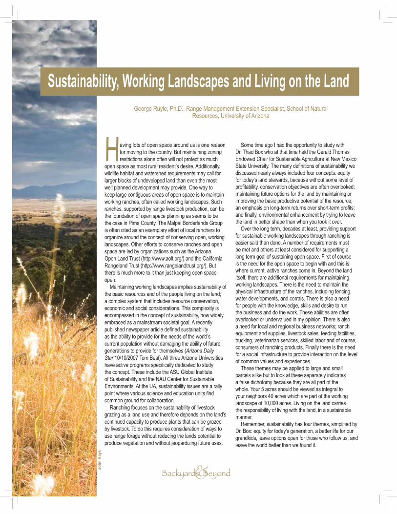
George Ruyle, Ph.D., Range Management Extension Specialist, School of Natural Resources, University of Arizona
Having lots of open space around us is one reason for moving to the country. But maintaining zoning restrictions alone often will not protect as much
open space as most rural resident’s desire. Additionally, wildlife habitat and watershed requirements may call for larger blocks of undeveloped land than even the most well planned development may provide. One way to keep large contiguous areas of open space is to maintain working ranches, often called working landscapes. Such ranches, supported by range livestock production, can be the foundation of open space planning as seems to be the case in Pima County. The Malpai Borderlands Group is often cited as an exemplary effort of local ranchers to organize around the concept of conserving open, working landscapes. Other efforts to conserve ranches and open space are led by organizations such as the Arizona Open Land Trust (http://www.aolt.org/) and the California Rangeland Trust (http://www.rangelandtrust.org/). But there is much more to it than just keeping open space open.
Maintaining working landscapes implies sustainability of the basic resources and of the people living on the land; a complex system that includes resource conservation, economic and social considerations. This complexity is encompassed in the concept of sustainability, now widely embraced as a mainstream societal goal. A recently published newspaper article defined sustainability as the ability to provide for the needs of the world’s current population without damaging the ability of future generations to provide for themselves (Arizona Daily Star 10/10/2007 Tom Beal). All three Arizona Universities have active programs specifically dedicated to study the concept. These include the ASU Global Institute of Sustainability and the NAU Center for Sustainable Environments. At the UA, sustainability issues are a rally point where various science and education units find common ground for collaboration.
Ranching focuses on the sustainability of livestock grazing as a land use and therefore depends on the land’s continued capacity to produce plants that can be grazed by livestock. To do this requires consideration of ways to use range forage without reducing the lands potential to produce vegetation and without jeopardizing future uses.
Some time ago I had the opportunity to study with Dr. Thad Box who at that time held the Gerald Thomas Endowed Chair for Sustainable Agriculture at New Mexico State University. The many definitions of sustainability we discussed nearly always included four concepts: equity for today’s land stewards, because without some level of profitability, conservation objectives are often overlooked; maintaining future options for the land by maintaining or improving the basic productive potential of the resource; an emphasis on long-term returns over short-term profits; and finally, environmental enhancement by trying to leave the land in better shape than when you took it over.
Over the long term, decades at least, providing support for sustainable working landscapes through ranching is easier said than done. A number of requirements must be met and others at least considered for supporting a long term goal of sustaining open space. First of course is the need for the open space to begin with and this is where current, active ranches come in. Beyond the land itself, there are additional requirements for maintaining working landscapes. There is the need to maintain the physical infrastructure of the ranches, including fencing, water developments, and corrals. There is also a need for people with the knowledge, skills and desire to run the business and do the work. These abilities are often overlooked or undervalued in my opinion. There is also a need for local and regional business networks; ranch equipment and supplies, livestock sales, feeding facilities, trucking, veterinarian services, skilled labor and of course, consumers of ranching products. Finally there is the need for a social infrastructure to provide interaction on the level of common values and experiences.
These themes may be applied to large and small parcels alike but to look at these separately indicates a false dichotomy because they are all part of the whole. Your 5 acres should be viewed as integral to your neighbors 40 acres which are part of the working landscape of 10,000 acres. Living on the land carries the responsibility of living with the land, in a sustainable manner.
Remember, sustainability has four themes, simplified by Dr. Box: equity for today’s generation, a better life for our grandkids, leave options open for those who follow us, and leave the world better than we found it.
Sustainability, Working Landscapes and Living on the LandJo
hn H
ays
4

5Winter 2007
When the thirteen colonies achieved their independence it generated many questions as to who would
have jurisdiction over the land and how it would be distributed. Did the land belong to the Indians, to the respective states, or to the central government? The argument was settled with the passing of the Land Ordinance of 1785 which provided for a rectangular system of survey. It drew from New England the idea of prior survey and orderly contiguous development and from the southern states it incorporated allocation directly to the individual. In terms of land distribution, the states fall into two classes: 1) State-land states where the state made the land grants and 2) Public-domain states where the federal government made the land grants.
Land in the state-land states, the original thirteen colonies, plus Maine, Vermont, Tennessee, Kentucky, Texas, West Virginia, and parts of Ohio, were surveyed with the Metes and Bounds surveying system. “Metes and bounds” refers to specific distance measurements (metes) and a general boundary description (bounds). This system uses natural land features, such as trees and streams, as well as neighboring land owners, along with distances to describe plots of land. An example of a metes and bound description might go something like this:
“Beginning at the black oak on the east bank of walnut creek, thence north 65 poles to the large standing rock, north 30 east 70 poles to the large oak tree, thence south 30 poles across the creek, thence east 40 poles to beginning.”
In the older indiscriminate metes and bounds, distance is measured in 16 ½ foot lengths which are interchangeably known as poles, rods, or
perches. The directions are
measured in degrees as compass bearings, beginning with the first direction listed and moving toward the second direction. Thus “north 30 east” means 30 degrees east of north.
Land in the public-domain states, as provided for in the Land Ordinance of 1785, was based on the Federal Township and Range System as illustrated and described below.
A baseline was run, east and west, and intersecting it at right angles every six miles are meridian lines (running north and south). The baseline and meridian meet in Arizona where the Gila and Salt Rivers meet. Baseline Road in Phoenix is named after our state’s baseline. The area between the two meridians is known as the “range.” From the intersection of these large meridians and baselines additional lines
State-Land and Public-Domain Survey SystemsSusan Pater, Extension Agent, 4-H Youth Development, University of Arizona Cooperative Extension, Cochise County

6&
Backyards Beyond
were set down to designate townships. Each township is six miles square, containing thirty-six one-mile square areas called sections. (Not all townships are exactly the same size due to the Earth’s curvature.) Each section contains 640 acres. Each section within the township is numbered in a zig zag fashion to aid in the original surveying. The land within a section is referred to as half and quarter sections. A one-sixteenth division is called a quarter of a quarter, as in the NW 1/4 of the NW 1/4. The descriptions are read from the smallest division to the largest. So, the example plot above would read as the southeast quarter of the northwest quarter of section 23, township one north, range one east. If you aren’t familiar with property descriptions take a look at your property tax statement. Where is your property located within your township?
Of the surveyed land, some of the land was held for the good of the nation at large. Section 16 in each township was set aside for schools, and sections 8, 11, 26 and 29 were reserved for future government purposes. However, these exact sections do not hold true for all western states, such as Arizona. In 1894 Arizona, Utah and New Mexico received four sections for education since the arid lands were thought to be less able to support schools. In Arizona Sections 1, 15, 32, and 36 were designated for schools. When school section lands were not available because they had been previously claimed the state was given the right to select equal acreage of Federal public domain land. The Bureau of Land Management is the custodian of the official land records of the United States.
Commonly Used Terms (from http://www.nationalatlas.gov/articles/boundaries/a_plss.html)
Base line—A parallel of latitude, or approximately a parallel of latitude, running through an arbitrary point chosen as the starting point for all sectionalized land within a given area.
Initial point—The starting point for a survey.Land Grant—A land grant is an area of land to which title was
conferred by a predecessor government and confirmed by the U.S Government after the territory in which it is situated was acquired by the United States. These lands were never part of the original public domain and were not subject to subdivision by the Public Land Survey System (PLSS).
Principal meridian—A meridian line running through an arbitrary point chosen as a starting point for all sectionalized land within a given area.
Public domain—Land owned by the Federal government for the benefit of the citizens. The original public domain included the lands that were turned over to the Federal Government by the Colonial States and the areas acquired later from the native Indians or foreign powers. Sometimes used interchangeably with Public lands.
Public lands—Lands in public ownership, therefore owned by the Federal government. Sometimes used interchangeably with Public domain.
Range—A vertical column of townships in the PLSS.Section—A one-square-mile block of land, containing 640 acres, or
approximately one thirty-sixth of a township. Due to the curvature of the Earth, sections may occasionally be slightly smaller than one square mile.
Township—An approximately 6-mile square area of land, containing 36 sections. Also, a horizontal row of townships in the PLSS.

7Winter 2007
KnowYourZoning
Contrary to popular belief, rural areas in Arizona are “zoned” by their respective county government. In addition to the other many duties that counties have on behalf of their residents,
such as taxing responsibilities, law enforcement, health standards, and road maintenance, Arizona Revised Statutes under Title 11 require land use planning and zoning. While planning is the process by which counties and their unincorporated communities determine the general category or designation of land uses for future development, zoning is the more specific determination of uses and development standards, such as lot sizes and setbacks, by zoning districts. Zoning is the mechanism by which government ensures uniform development in ad-dition to minimizing impacts to neighboring properties. This may not be new information to many, but the perception of the “wild frontier” free of regulation is still pervasive in sparsely populated areas. Certain general agriculture and ranching activities are statutorily exempt from zoning regulations in Arizona, but this isn’t the case for all other uses such as residential dwellings.
Where should a land owner go to find out about their zoning? A good place to start is the Internet and a county’s website for planning and zoning. Most counties in the state have a website usually chocked full of information on obtaining building permits, approval processes for land uses, and most importantly—their zoning regulations. Typing in the county’s name into any search engine will often pull up that county’s official website. From there, it’s usually one or two clicks to get to the county’s webpage for “Community Development” or “Planning and Zoning.” If the zoning regulations are not online, there is often contact information to obtain them.
So what should a land owner know about their zoning district? For one thing, the number of structures or houses they can build on their parcel of land. Zoning districts specify densities of residential development, usually based on square footages or acreage of land. For example, the vast majority of rural areas in Cochise County in the southeastern part of the state is zoned “Rural” with a minimum lot size of four acres. That means that if a land owner purchases a three acre parcel, they would not be able to obtain a building permit to construct a house for their family without an arduous, and likely unsuccessful, attempt to change their zoning.
In addition to a minimum lot size, and other development standards, zoning regulations will specify minimum distances, or setbacks from property boundaries and roads. Floodplain regulations will also dictate minimum distances from significant washes—even if they are dry most of the year.
Lastly, the activities a land owner can or cannot do on his or her property are described by zoning district. Some more intensive uses of rural property, such as manufacturing or other industrial activities may not be allowed at all. Or, they may only be allowed through a public hearing and special approval process with a county’s planning and zoning commission. Other less intensive uses, like a small bed and breakfast may be a use by right, but still require a permitting process to ensure that development meets the zoning district’s standards.
Rural properties, though sparsely populated and often remote, exist in a relationship to neighboring properties as well as the environment as a whole. Zoning standards are intended to minimize conflicts that may arise in those relationships.
Mark Apel, Area Extension Agent, Community Resources Development, University of Arizona Cooperative Extension, Southeastern Arizona
8&
Backyards Beyond
Many people live in rural areas with space (and zoning) that can support small poultry flocks. Poultry can benefit you in several ways: 1) food from eggs and/or meat; 2) weed control; 3) insect/
snail/slug control; and 4) nutrient-rich manure that can be composted or used as a garden soil amendment. Beside these benefits, home food production is fun, educational, and rewarding.
For gardening and manure production, a small flock of chickens is ideal. Manure can be collected inside the pen and the night roosting area (chicken house). Free ranging chickens also fertilize the area, but it’s difficult to collect the manure (except on the bottoms of your shoes). Chicken manure contains a good balance of essential plant nutrients. On average, it will have about 1-2% nitrogen, 1-2% phosphorus, and 1% potassium. If chicken manure is directly incorporated into soil, planting should be delayed for about a month. If composted, the nitrogen in the manure will enhance biological activity and consequent breakdown of other materials. Composting is recommended for bedding that contains shavings or straw.
An egg-producing chicken flock should be replaced every two or so years to maintain production levels. Buy chicks from reputable sources. Local feed stores usually get chicks in early spring. However, catalogs ship day-old chicks via air mail through summer and into fall. Some suppliers will determine sex of the chicks (with about 95% or greater reliability) for a little extra money. By the way, you do not need a rooster to produce eggs. In fact, the absence of roosters may be greatly appreciated by your neighbors. Young chicks need lots of care during the first few weeks and you should be prepared for them when they arrive. Reputable suppliers will provide feeding and care instructions.
The smaller the hen, the more efficient her production which also lowers your feed cost per dozen eggs. Leghorns and sex-link crosses have been developed for egg production and disease resistance. Most
pullets come into egg production at 20 to 24 weeks or age. You can expect about a dozen eggs from each four to five pounds of feed.
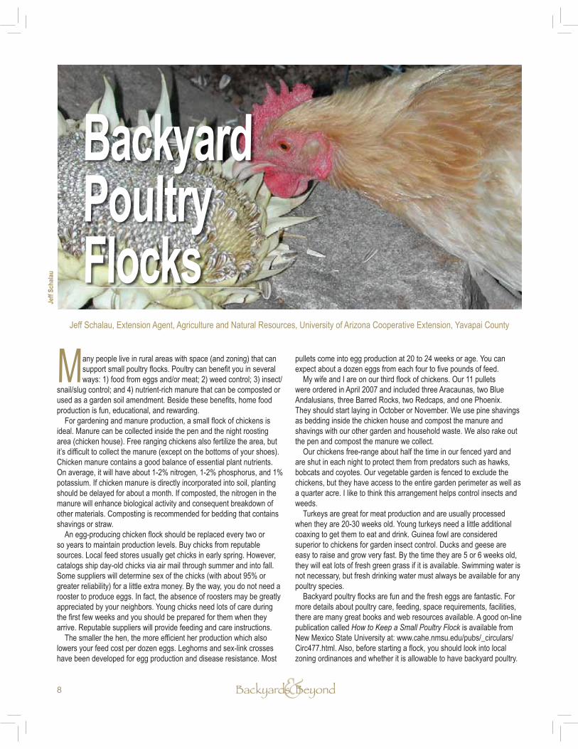
My wife and I are on our third flock of chickens. Our 11 pullets were ordered in April 2007 and included three Aracaunas, two Blue Andalusians, three Barred Rocks, two Redcaps, and one Phoenix. They should start laying in October or November. We use pine shavings as bedding inside the chicken house and compost the manure and shavings with our other garden and household waste. We also rake out the pen and compost the manure we collect.
Our chickens free-range about half the time in our fenced yard and are shut in each night to protect them from predators such as hawks, bobcats and coyotes. Our vegetable garden is fenced to exclude the chickens, but they have access to the entire garden perimeter as well as a quarter acre. I like to think this arrangement helps control insects and weeds.
Turkeys are great for meat production and are usually processed when they are 20-30 weeks old. Young turkeys need a little additional coaxing to get them to eat and drink. Guinea fowl are considered superior to chickens for garden insect control. Ducks and geese are easy to raise and grow very fast. By the time they are 5 or 6 weeks old, they will eat lots of fresh green grass if it is available. Swimming water is not necessary, but fresh drinking water must always be available for any poultry species.
Backyard poultry flocks are fun and the fresh eggs are fantastic. For more details about poultry care, feeding, space requirements, facilities, there are many great books and web resources available. A good on-line publication called How to Keep a Small Poultry Flock is available from New Mexico State University at: www.cahe.nmsu.edu/pubs/_circulars/Circ477.html. Also, before starting a flock, you should look into local zoning ordinances and whether it is allowable to have backyard poultry.
Backyard Poultry Flocks
Jeff Schalau, Extension Agent, Agriculture and Natural Resources, University of Arizona Cooperative Extension, Yavapai County
Jeff
Scha
lau
9Winter 2007
Winter weather often sends rodents looking for a warm, dry place to live. The house mouse (Mus musculus) is a common pest in houses and outbuildings. It is well adapted to sharing our living
space and resources and has been doing so for thousands of years. These little pests can share other things with us too: like diseases and parasites. Learning about their life cycle, habits, and preferences will help you to understand and control them.
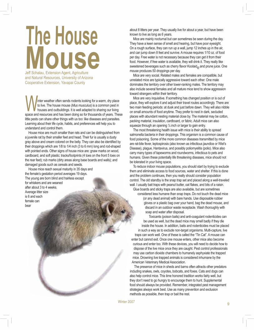
House mice are much smaller than rats and can be distinguished from a juvenile rat by their smaller feet and head. Their fur is usually a dusty gray above and cream colored on the belly. They can also be identified by their droppings which are 1/8 to 1/4 inch (3 to 6 mm) long and rod-shaped with pointed ends. Other signs of house mice are: gnaw marks on wood, cardboard, and soft plastic; tracks/footprints (4 toes on the front 5 toes on the rear feet); rub marks (dirty areas along base boards and walls); and damaged goods such as cereals and seeds.
House mice reach sexual maturity in 35 days and the female’s gestation period averages 19 days. The young are born blind and hairless except for whiskers and are weaned after about 3 to 4 weeks. Average litter size is 6 and each female can bear
about 8 litters per year. They usually live for about a year, but have been known to live as long as 6 years.
Mice are mainly nocturnal but can sometimes be seen during the day. They have a keen sense of smell and hearing, but have poor eyesight. On a rough surface, they can run up a wall, jump 12 inches up in the air, and can jump down 8 feet and survive. A mouse requires 1/10 oz. of food per day. Free water is not necessary because they can get it from their food. However, if free water is available, they will drink it. They really like sweetened beverages such as cherry flavor Koolaid® and prune juice. One mouse produces 50 droppings per day.
Mice are very social. Related males and females are compatible, but unrelated mice are typically aggressive toward each other. One male dominates the territory over other lower-ranking males. The territory may also include several females and all mature mice tend to show aggression toward strangers within their territory.
Mice are very inquisitive. If something has changed position or is out of place, they will explore it and adjust their travel routes accordingly. There are two main feeding periods: at dusk and just before dawn. They will also nibble on small amounts of food anytime. They prefer to nest in dark, secluded places with abundant nesting material close by. The material may be cotton, packing material, insulation, cardboard, or fabric. Adult mice can also squeeze through an opening ¼ inch or larger to gain entry.
The most threatening health issue with mice is their ability to spread salmonella bacteria in their droppings. This organism is a common cause of food poisoning. Some of the more common diseases transmitted by mice are rat-bite fever, leptospirosis (also known as infectious jaundice or Wiel’s Disease), plague, Hantavirus, and possibly poliomyelitis (polio). Mice also carry many types of tapeworms and roundworms, infectious to pets and humans. Given these potentially life threatening diseases, mice should not be tolerated in your living space.
To reduce indoor mouse populations, you should start by trying to exclude them and eliminate access to food sources, water and shelter. If this is done and the problem continues, then you really should consider population control. The old standby is the snap trap set and placed along a well-traveled wall. I usually bait traps with peanut butter, oat flakes, and bits of a raisin.
Glue boards and sticky traps are also available, but are sometimes considered less humane than snap traps. Do not touch the dead mice
(or any dead animal) with bare hands. Use disposable rubber gloves or a plastic bag over your hand, bag the dead mouse, and discard in an outdoor waste receptacle. Wash thoroughly with soap and water after disposal.
Toxicants (poison baits) and anti-coagulant rodenticides can be used as well, but the dead mice may smell badly if they die
inside the house. In addition, baits and rodenticides must be placed in such a way as to exclude non-target organisms. Multi-capture, live
traps can work well. One of these is called the “Tin Cat”. A mouse can enter but cannot exit. Once one mouse enters, other mice also become curious and enter too. With these devices, you will need to decide how to dispose of the live mice once they are caught. Pest control professionals may use carbon dioxide chambers to humanely asphyxiate the trapped mice. Drowning live trapped animals is considered inhumane by the American Veterinary Medical Association.
The presence of mice in sheds and barns often attracts other predators including snakes, owls, coyotes, bobcats, and foxes. Cats and dogs can also help control mice. This time honored tradition works fairly well, but they don’t need to go hungry to encourage them to hunt. Supplemental food should always be provided. Remember, integrated pest management strategies always work best. Use as many prevention and exclusion methods as possible, then trap or bait the rest.
The HouseMouseJeff Schalau, Extension Agent, Agriculture and Natural Resources, University of Arizona Cooperative Extension, Yavapai County
10&
Backyards Beyond
You may have heard the television or radio meteorologist mention that this winter looks like it is going to be a dry one. You may have
also thought to your self ‘how could they possibly know that?’. If they mentioned the words ‘La Niña’ this year or ‘El Niño’ in other years then that can clue you in to what weather forecasters are seeing down the road ahead.
So what are El Niño and La Niña?El Niño literally means, the Christ Child, referring
to a periodic warming of water along the South American coast noticed by fishermen around Christmas. Scientists have adopted the term to refer to the broader, periodic shift towards warmer-than-average waters in the eastern Pacific and the accompanying shift in larger-scale circulation patterns. El Niño is the warm phase of the El Niño-Southern Oscillation (ENSO) which typically cycles between a warm phase (El Niño) and cool phase (La Niña where water in the eastern Pacific is unusually cool) every three to seven years. El Niño and La Niña events can have major impacts on global circulation patterns by shifting major areas of warm water and accompanying thunderstorms back and forth across the Pacific Ocean. The position of large areas of warm water and thunderstorms can impact the location of surface high and low pressure systems and the track of jet streams. Global impacts can include extreme drought in some locations while other areas experience extreme flooding.
Why should I care? I don’t live near the Pacific Ocean
El Niña and La Niña events produce disruptions to larger-circulation patterns very distant from
their center of action in the Pacific. This is called a teleconnection pattern. Over a season, global-scale circulation patterns will adjust to the changes occurring across the Pacific. In Arizona, we can experience a teleconnection as a strengthening of the sub-tropical jet stream during an El Niño event. The sub-tropical jet can be an excellent mechanism to deliver moisture and energy for winter storms across the entire southern U.S. and especially so when an El Niño event is underway. This teleconnection with either El Niño or La Niña is strongest during the winter season in Arizona because of their ability to disrupt jet-stream patterns and storm tracks that are important for winter precipitation.
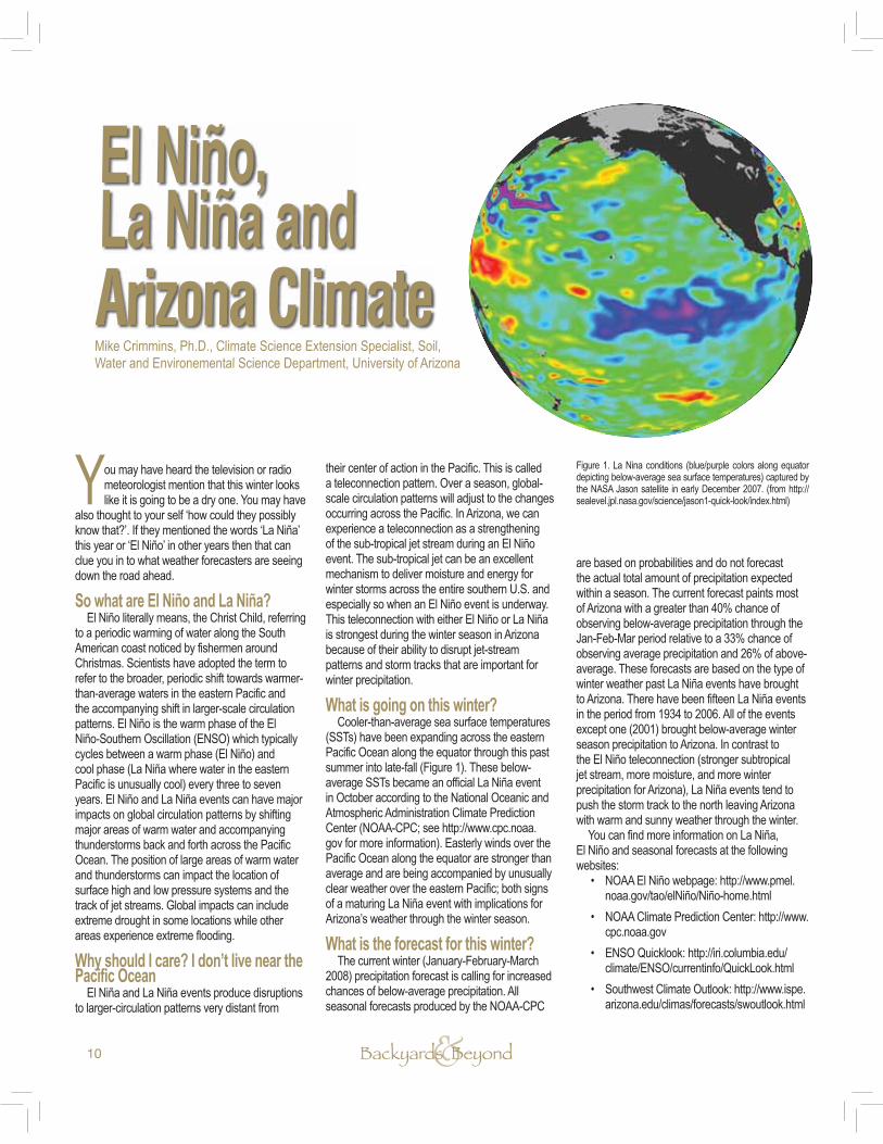
What is going on this winter? Cooler-than-average sea surface temperatures
(SSTs) have been expanding across the eastern Pacific Ocean along the equator through this past summer into late-fall (Figure 1). These below-average SSTs became an official La Niña event in October according to the National Oceanic and Atmospheric Administration Climate Prediction Center (NOAA-CPC; see http://www.cpc.noaa.gov for more information). Easterly winds over the Pacific Ocean along the equator are stronger than average and are being accompanied by unusually clear weather over the eastern Pacific; both signs of a maturing La Niña event with implications for Arizona’s weather through the winter season.
What is the forecast for this winter?The current winter (January-February-March
2008) precipitation forecast is calling for increased chances of below-average precipitation. All seasonal forecasts produced by the NOAA-CPC
Mike Crimmins, Ph.D., Climate Science Extension Specialist, Soil, Water and Environemental Science Department, University of Arizona
Figure 1. La Nina conditions (blue/purple colors along equator depicting below-average sea surface temperatures) captured by the NASA Jason satellite in early December 2007. (from http://sealevel.jpl.nasa.gov/science/jason1-quick-look/index.html)
are based on probabilities and do not forecast the actual total amount of precipitation expected within a season. The current forecast paints most of Arizona with a greater than 40% chance of observing below-average precipitation through the Jan-Feb-Mar period relative to a 33% chance of observing average precipitation and 26% of above-average. These forecasts are based on the type of winter weather past La Niña events have brought to Arizona. There have been fifteen La Niña events in the period from 1934 to 2006. All of the events except one (2001) brought below-average winter season precipitation to Arizona. In contrast to the El Niño teleconnection (stronger subtropical jet stream, more moisture, and more winter precipitation for Arizona), La Niña events tend to push the storm track to the north leaving Arizona with warm and sunny weather through the winter.
You can find more information on La Niña, El Niño and seasonal forecasts at the following websites:
• NOAA El Niño webpage: http://www.pmel.noaa.gov/tao/elNiño/Niño-home.html
• NOAA Climate Prediction Center: http://www.cpc.noaa.gov
• ENSO Quicklook: http://iri.columbia.edu/climate/ENSO/currentinfo/QuickLook.html
• Southwest Climate Outlook: http://www.ispe.arizona.edu/climas/forecasts/swoutlook.html
El Niño, La Niña andArizona Climate

11Winter 2007
Animal Weigh?Susan Pater, Extension Agent, 4-H Youth Development, University of Arizona Cooperative Extension, Cochise County
How Much Does Your
Livestock owners often need to know the weight of their animals in order to determine proper feed rations, to adminster the proper dosage of a medication, or to track how individual
animals grow and use their feed. Approved and properly calibrated livestock scales are the most accurate and consistent method for determining body weight. However, there are several methods that can be used to determine an animal’s weight when access to scales is not possible: visual observation or guessing, weigh tapes, and weight estimation formulas.
Visual observation is usually very inaccurate and not recommended for use when determining rations, medication dosages, or when an accurate weight is important.
Weigh tapes are specially marked tapes used to measure the heart girth and convert that measurement to a fairly accurate estimate of the animal’s body weight. Weigh tapes are easy to use and can be utilized effectively for monitoring purposes when used in a consistent manner by the same person. They can be purchased for cattle, sheep, goats, hogs and horses through various livestock supply companies.
With weight estimation formulas, a common tape measure is used to determine the heart girth and body length measurement. These measurements are then used to calculate the animal’s weight. The weight estimation formulas described below are usually more accurate than a weigh tape and almost always more accurate than visual observation in determining an animal’s weight.
Beef Cattle1. Measure the length of body, from the point-of-shoulder (A)
to the point-of-rump or pin bone (B).
2. Measure the circumference or heart girth (C). Measure from a point slightly behind the shoulder blade, down the fore-ribs and under the body behind the elbow all the way around. After these measurements are made in inches – use the following formula.
3. (Heart girth X heart girth X body length) ÷ 300 = weight in pounds.
12&
Backyards Beyond
Example:Heart girth (76”) X heart girth (76”) X body length (66”)
divided by 300 = 1,270 pounds.
76 X 76 = 5,776
5,776 X 66 = 381,216
381,216 divided by 300 = 1,270 pounds
Sheep and GoatsFor sheep and goats, use the same method described for beef cattle. When working with unshorn sheep, be sure to part or compress the wool to insure an accurate heart girth measurement.
Hogs1. Measure the length of body from A to B. Do this by restraining
the animal and measuring the length of body from between the ears (poll) over the backbone to the base of the tail.
2. Measure the circumference (heart girth) of body (C). After these measurements are made in inches – use the following formula.
3. (Heart girth X heart girth X body length) ÷ 400 = weight in pounds
Note: For hogs weighing less than 150 pounds, add 7 pounds to the weight figure from this formula; for hogs weighing 150 to 400 pounds, no further adjustment is needed.
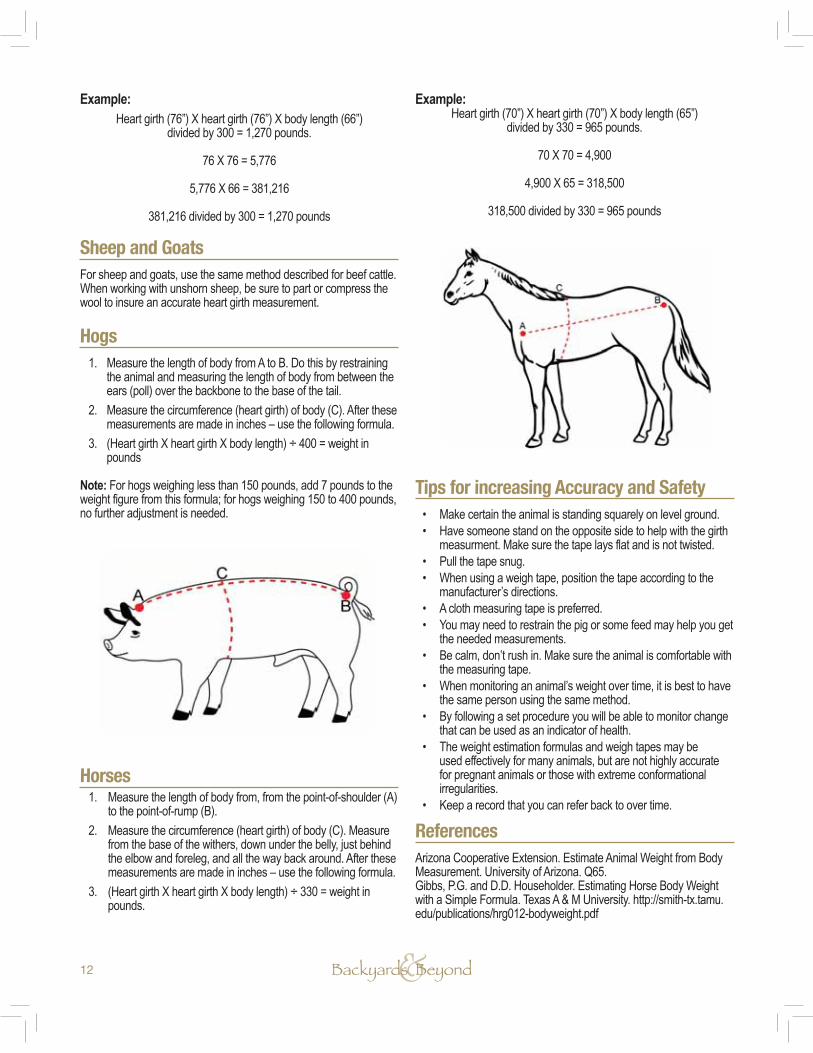
Horses1. Measure the length of body from, from the point-of-shoulder (A)
to the point-of-rump (B).
2. Measure the circumference (heart girth) of body (C). Measure from the base of the withers, down under the belly, just behind the elbow and foreleg, and all the way back around. After these measurements are made in inches – use the following formula.
3. (Heart girth X heart girth X body length) ÷ 330 = weight in pounds.
Example:Heart girth (70”) X heart girth (70”) X body length (65”)
divided by 330 = 965 pounds.
70 X 70 = 4,900
4,900 X 65 = 318,500
318,500 divided by 330 = 965 pounds
Tips for increasing Accuracy and Safety• Make certain the animal is standing squarely on level ground.• Have someone stand on the opposite side to help with the girth
measurment. Make sure the tape lays flat and is not twisted.• Pull the tape snug.• When using a weigh tape, position the tape according to the
manufacturer’s directions.• A cloth measuring tape is preferred.• You may need to restrain the pig or some feed may help you get
the needed measurements.• Be calm, don’t rush in. Make sure the animal is comfortable with
the measuring tape. • When monitoring an animal’s weight over time, it is best to have
the same person using the same method.• By following a set procedure you will be able to monitor change
that can be used as an indicator of health.• The weight estimation formulas and weigh tapes may be
used effectively for many animals, but are not highly accurate for pregnant animals or those with extreme conformational irregularities.
• Keep a record that you can refer back to over time.
ReferencesArizona Cooperative Extension. Estimate Animal Weight from Body Measurement. University of Arizona. Q65.Gibbs, P.G. and D.D. Householder. Estimating Horse Body Weight with a Simple Formula. Texas A & M University. http://smith-tx.tamu.edu/publications/hrg012-bodyweight.pdf
13Winter 2007
Water in the west: We know we need it, we know it’s a precious commodity; we know lots of people keep track of it. But how do we get to information that can help us manage it in a
sustainable manner? In Arizona, diverse agencies, researchers and institutions gather,
archive and present water-related information independently. The United States Geological Survey and the Arizona Department of Water Resources (ADWR) produce the greatest amount of water-related data but many other organizations generate, store and manipulate data about precipitation, wells, water resources, water quality, and riparian areas. The Salt River Project, the Central Arizona Project, the Bureau of Reclamation, counties, cities, universities, federal land management agencies and non-governmental entities such as The Nature Conservancy and individual citizens all produce facts, figures and numbers that they store in databases located in many different places and often on individual computers. Data are not shared even among researchers and within agencies let alone widely disseminated for use by landowners or the general public.
One of the most common concerns from individuals and professionals about water is the lack of hydrologic information or lack of access to hydrologic information. When these data become easily accessible, people can use and even combine the information sets available to produce new methods for solving ever more complex problems. A real need exists for a one-stop information resource. The easiest place to build this is on the Internet using web services, which are used to locate data and transform them into formats required by a particular user.
Rural Arizonans can benefit more than most people from easy and comprehensive web access to information about water in Arizona. They can benefit indirectly from research at universities that improves understanding, quality and sources. They can benefit directly by being informed about wells, drought and flood events that can affect their land and information that leads to more sustainable practices.
Established in 2006, the Arizona Water Institute (AWI) is a consortium of the three state universities (Arizona State University, Northern Arizona University and the University of Arizona) in partnership with three state agencies (Commerce, Environmental Quality and Water Resources). AWI’s mission is to provide access to hydrologic information, to support communities and to develop technologies to promote water sustainability. One project that promotes all three aspects of its mission is the Arizona Hydrologic Information System (AHIS).
AHIS is one of the priority projects for AWI. AHIS is a one-stop resource that provides user-friendly access to water-related data. AHIS development began as one of AWI’s four first year projects and continues as an ongoing effort of AWI in partnership with agencies, researchers and water-related centers – AHIS is an important long-term investment.
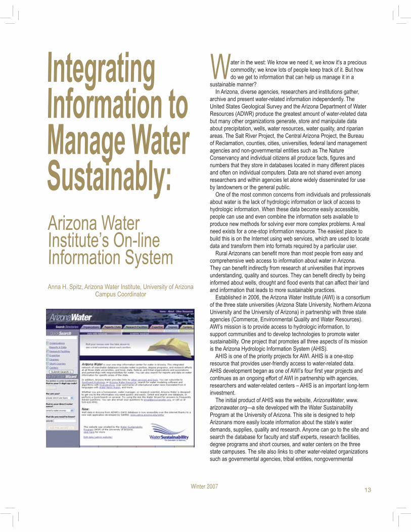
The initial product of AHIS was the website, ArizonaWater, www.arizonawater.org—a site developed with the Water Sustainability Program at the University of Arizona. This site is designed to help Arizonans more easily locate information about the state’s water demands, supplies, quality and research. Anyone can go to the site and search the database for faculty and staff experts, research facilities, degree programs and short courses, and water centers on the three state campuses. The site also links to other water-related organizations such as governmental agencies, tribal entities, nongovernmental
Integrating Information to Manage Water Sustainably: Arizona Water Institute’s On-line Information SystemAnna H. Spitz, Arizona Water Institute, University of Arizona
Campus Coordinator

14&
Backyards Beyond
organizations, private firms and professional organizations. Visitors to the site can sort the data by regions, scientific disciplines, organization types, schools and other mechanisms to narrow down searches to provide the most useful results.
The second product developed with ADWR, the US Geological Survey and the University of Arizona’s Sustainability of semi-Arid Hydrology and Riparian Areas (SAHRA) is ArizonaWells, the access system for the ADWR wells databases found at www.sahra.arizona.edu/wells/. This site is designed to help homeowners, water professionals and state agency workers locate well information more easily. Site visitors can find well locations, water level, ownership and water quality information found in government databases.
AHIS programmers and scientists continue to develop products for the public, government and researchers. Working with a growing list of local, regional, national and even international partners at universities, governmental and non-governmental groups, AWI partnerships and collaborations are expanding the database accessibility and developing new services for AHIS. Current work includes accessing ground- and surface water quality data from the Arizona Department of Environmental Quality. Plans to establish a framework to build knowledge, analyze complex environmental changes and address
water management questions are underway for the southwest US—a region facing long-term drought and climate change impacts. AWI is also working with national organizations to incorporate the Arizona data and interfaces into national systems. In the coming year, the AHIS team will develop a central web portal through which state agencies, researchers, private sector partners and the public will be able to easily share data and acquire water-related data. Portals present information from diverse sources in a unified way. All these efforts will serve Arizona water users and managers, as well as researchers.
AHIS offers “one-stop shopping” for water-related data for the full range of users, from the public to water professionals to academic researchers. AHIS enables agencies, academic institutions, policymakers, consultants, researchers and others access to catalogs for data discovery and real-time connections to appropriately prepared data. It is designed to work easily and comprehensively for users to benefit their water use, management and research for a more sustainable future.
Visit the Arizona Water Institute website at www.azwaterinstitute.org for ongoing developments. AHIS is developing its own web portal for launch in 2008.
15Winter 2007
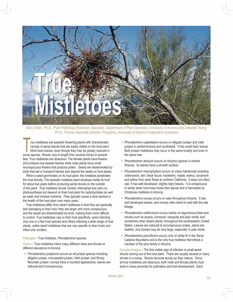
True mistletoes are parasitic flowering plants with characteristic clumps of aerial shoots that are easily visible on the host plant. Most have leaves, even though they may be greatly reduced in
some species. Shoots vary in length from several inches to several feet. True mistletoes are dioecious. The female plants have flowers and produce one-seeded berries while male plants have small inconspicuous flowers that produce pollen. Seeds are disseminated by birds that eat or transport berries and deposit the seeds on host plants.
When a seed germinates on its host plant, the mistletoe penetrates the host directly. The parasitic mistletoe plant develops inside its host for about two years before producing aerial shoots on the outside of the plant. True mistletoe shoots contain chlorophyll and carry on photosynthesis but depend on their host plant for carbohydrates as well as water and mineral nutrients. They typically cause a slow decline in the health of the host plant over many years.
True mistletoes differ from dwarf mistletoes in that they are generally less damaging to their host; they are larger and more conspicuous; and the seeds are disseminated by birds, making them more difficult to control. True mistletoes vary in their host specificity, some infecting only one or a few host species and others infecting a wide range of host plants, unlike dwarf mistletoes that are very specific to their hosts and infect only conifers.
Pathogen – True mistletoe, Phoradendron species
Hosts – True mistletoes infect many different trees and shrubs at different elevations in Arizona:
• Phoradendron juniperum occurs on all juniper species including alligator juniper, one-seeded juniper, Utah juniper, and Rocky Mountain juniper; clumps have a rounded appearance; leaves are reduced and inconspicuous.
• Phoradendron capitellatum occurs on alligator juniper and Utah juniper in central Arizona and southward. It has small hairy leaves. Both juniper mistletoes may occur in the same locality and even in the same tree.
• Phoradendron densum occurs on Arizona cypress in central Arizona. Its leaves have a smooth surface.
• Phoradendron macrophyllum occurs on many hardwoods including cottonwood, ash, black locust, hackberry, maple, walnut, sycamore and willow from west Texas to northern California. It does not infect oak. It has well developed, slightly hairy leaves. It is conspicuous in winter when host trees loose their leaves and is harvested as Christmas mistletoe in Arizona.
• Phoradendron coryae occurs on oaks throughout Arizona. It has well developed leaves, and clumps often blend in well with the oak foliage.
• Phoradendron californicum occurs mainly on leguminous trees and shrubs such as acacia, ironwood, mesquite and palo verde, and sometimes other desert plants, throughout the southwestern United States. Leaves are reduced to inconspicuous scales, stems are reddish, and clumps may be very large, especially in palo verde.
• Phoradendron pauciflorum occurs only on white fir in the Santa Catalina Mountains and is the only true mistletoe that infects a member of the pine family in Arizona.
Symptoms/signs – The first visible sign of infection is small aerial shoots coming out of the host plant. There are usually several or many shoots in a clump. Shoots become woody as they mature. Since all true mistletoes are dioecious, both male and female plants must exist in close proximity for pollination and fruit development. Each
True Mistletoes
Mary Olsen, Ph.D., Plant Pathology Extension Specialist, Department of Plant Sciences, University of Arizona and Deborah Young, Ph.D., Former Associate Director, Programs, University of Arizona Cooperative Extension
16&
Backyards Beyond
clump may develop into a large conspicuous growth. Swelling and branch distortions often occur at infection sites, and infected wood is weakened.
Disease – Mistletoes must have a living host plant on which to grow. Although true mistletoes are flowering plants and contain chlorophyll, they have no true roots and must obtain some carbohydrates as well as all their water and mineral nutrients from their hosts. Infections cause reduced host vigor because mistletoes compete with their hosts for nutrients and water.
Mistletoe seeds are disseminated by birds in several ways, depending on bird species. Seeds are disseminated as birds (1) wipe them off while preening, resulting primarily in dispersal in one host; (2) regurgitate them, resulting in dispersal to nearby hosts; or (3) excrete them after feeding on the berries, resulting in dispersal in a larger area.
The seeds germinate on host plants and penetrate directly by root-like structures that become progressively buried in the host wood. These structures (cortical haustoria in the phloem and sinkers in the wood) enable the mistletoe to acquire water and nutrients from the host. True mistletoes develop inside the host for up to two years before sending out aerial shoots.
Environmental conditions – Vigor of true mistletoe plants is usually related to that of the host, and it may decline in otherwise healthy trees during dry periods when host plants are water stressed. On the other hand, heavily infected trees are probably more susceptible to other stresses and insect infections. Seeds of most species require moisture for germination, so infections occur during rainy periods.
Prevention/control – Prevention of true mistletoe infections is very difficult since birds disseminate the seeds over large areas. True mistletoes are not aggressive pathogens, and it can take decades for mature, infested trees to die. Therefore, planting young trees, especially those that are not hosts, near older trees before they are removed or die is recommended. Young or small trees are seldom infected because birds prefer to perch in the tops of taller and/or more mature trees. Periodic recruitment of new young trees among older infested trees also allows some mistletoe to remain as part of the landscape. Since the berries of true mistletoes mature in winter, they are an important winter food source for many bird species. Clumps of mistletoe growth are also attractive nesting sites.
Area wide efforts to clean out trees in an entire neighborhood or development may be effective in preventing infections in new trees, but require the cooperation of a large number of people including homeowners, businesses and public agencies. Without community cooperation, infestations will recur.
Control of true mistletoe depends on physical removal of the aerial shoots from the host plant by pruning infected branches or by periodic removal of the shoots. Breaking off shoots every two or three years will reduce competition between the mistletoe and the host. Repetitive pruning also will prevent spread since the mistletoe will not have a chance to produce seed, but aerial shoot removal does not eradicate the mistletoe. Shoots also may be removed by application of ethefon products (ethylene) that cause abscission of the shoots but do not kill the internal infection. Infested limbs can be cut out every year at least one foot below the infection site or preferably pruned at the nearest crotch. Periodic aerial shoot removal is the only control in trees with main stem or trunk infections. For trees and shrubs where a heavy infestation has persisted for several years, removal may be the only remedy.
At a Glance
• True mistletoes are parasitic flowering plants with characteristic clumps of growth that are easily visible on the host plant.
• True mistletoe seeds are disseminated by birds that eat or transport the berries and deposit seeds on host plants.
• True mistletoes reduce the growth of infected hosts, but it usually takes many years for true mistletoe infections to kill a mature tree or shrub.
• True mistletoes are controlled by periodic manual removal of aerial shoots, by cutting off infected branches and by removal of heavily infested trees and shrubs.
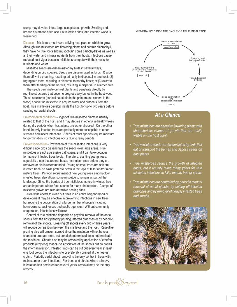
GENERALIZED DISEASE CYCLE OF TRUE MISTLETOE
aerial shoots visibleon host
year 2 and after
flowering andberry production
seed dispersalby birds
seed germinationand
penetration into host
year 1
initial developmentof sinkers and haustoria
in host tissue
year 1 - 2

17Winter 2007
Have you ever wondered why an animal behaves in a certain way? Animals learn about the consequences of their actions and their environment via two basic ways, operant conditioning and classical (or Pavlovian or respondent) conditioning.
Understanding operant and classical conditioning can help us to understand why animals behave the way they do as well as help us to train animals to behave in desirable ways.
Operant conditioning occurs when an animal voluntarily modifies its behavior following positive or negative consequences. Reinforcement and
punishment are the primary tools used by animal trainers to condition certain behaviors via operant conditioning. When a desired behavior
is rewarded by positive reinforcement (usually an attractive food or treat) the rate of the desired behavior increases, while the
opposite is true when punishment is administered. Most animal behavior experts concur that animals respond
more effectively to operant conditioning when positive reinforcement is used rather than punishment.
Classical conditioning occurs when an animal is presented with a previously neutral stimulus along with a stimulus of significance to elicit a “conditioned,”
involuntary response. For example, Ivan Pavlov noticed that dogs quickly learned to salivate when the lab technician who normally fed them entered the room. Pavlov also demonstrated that dogs learned to salivate in response to the sound of a bell (or metronome) after it and a food were paired on a few occasions. In both of these classical
conditioning examples, animals learned to associate a previously neutral stimulus (lab tech, bell, metronome) with an imminent food reward.
Both operant and classical conditioning involve learning about associations. However, an important difference between these two modes of learning is that classical conditioning involves an association between two stimuli, while operant conditioning involves learning the association between an animal’s behavior and the consequence immediately following
the behavior. Another important distinction is that classical conditioning involves modification of an involuntary or reflexive behavior, while operant
conditioning involves modification of a voluntary behavior. Both kinds of learning can be shaped by nature or by man.
Animal trainers use both operant and classical conditioning to teach animals to behave in certain ways. For example, dog trainers often use
treats to operantly instruct their dogs to sit, stay, come, etc. If the dog performs appropriately they are given a treat immediately following the desired behavior. With enough repetitions, dogs learn to associate appropriate behaviors with the positive consequences of receiving the treat. If an animal behaves inappropriately, it does
the Way They Do?Why Do Animals Behave
Larry D. Howery, Ph.D., Range Management Extension Specialist, School of Natural Resources, University of Arizona

18&
Backyards Beyond
not receive the treat and the inappropriate behavior will decline. Some animal trainers (especially marine animal trainers) use a “clicker” or a whistle to signal that a reward is forthcoming. Marine animal trainers use these tools because it is more difficult to reward a marine animal immediately after it performs a trick. Marine animals are first trained to associate the sound of the previously neutral clicker or whistle with a treat (i.e., learning the association between two stimuli – sound, then food, via classical conditioning). Then, when a desirable behavior occurs, the animal first hears the sound signifying that it has performed appropriately, and soon after receives the treat (i.e., learning the association between an appropriate behavior and its consequence via operant conditioning). Perhaps you have observed marine animal trainers using clickers or whistles to train whales, dolphins, and seals to do some amazing, sophisticated tricks using a combination of operant and classical conditioning. If you have ever watched a dog show, you have witnessed the principles and power of animal training and behavior.
Below are some examples of animal and human learning that you may have observed in your everyday life. Ask yourself the question, is this an example of operant or classical conditioning? Or both? Can you think of other examples?
‹ Birds learn the locations of feeders and other food sources.‹ Livestock learn to come to a truck to be fed or to move to a
new pasture at the sound of a horn.‹ Livestock learn to avoid areas surrounded by an electric
fence.
‹ Cats come running to the sound of a can opener.‹ Children work hard to earn good grades in anticipation of a
reward (or to avoid punishment!).‹ Animals learn to form preferences or aversions by
associating the taste of a food with its post-ingestive feedback.
‹ You try new food at a restaurant that causes food poisoning. The next time you smell the food, you feel nauseous.
‹ The smell of fresh baked bread makes your mouth water.‹ You get paid for working.‹ Child gets a dessert for eating her vegetables or ice cream
for begging incessantly.‹ Dog gets attention from people when he barks.‹ Toddler gets picked up and comforted for screaming.‹ Man hits a $20 “jackpot” and puts $100 more in the slot
machine.‹ Nurse says “Now this won’t hurt a bit” just before giving you
a shot. The next time you hear “This won’t hurt” you recoil.In some of these examples you may have noticed that we
sometimes unwittingly train unwanted behavior in our animals, our children, and even ourselves. It is important to keep in mind that for both operant and classical conditioning, behavior is a function of its consequences. When positive (negative) consequences follow a certain behavior, that behavior typically increases (decreases). To learn more about animal behavior as it pertains to wild and domesticated grazing animals check out http://behave.net.
Practice Being a Good Neighbor take responsibility to maintain the quality of life you and your neighbors desire
´ Establish good neighbor relationships. Practice citizenship, contribute to the community and respect neighboring properties and the rights of others.
´ Respect trespassing laws and inform children about safety issues. Many times neighboring properties are inviting playgrounds full of potential risks, i.e. equipment, ponds, large animals, rough terrain.
´ Assume responsibility for sustaining land, water and environmental quality. Attend educational programs and use resources of Coop-erative Extension, your Natural Resource Conservation District, the Game and Fish Department and other available resources.
´ Determine impact to others when you make decisions regarding your property. Examples include planting trees that eventually grow into power lines or clearing land that accelerates erosion.
´ Understand ownership responsibilities for pets, horses and other livestock. Loose animals cause safety concerns and overgrazing of your land can bring negative impact to adjoining property.
´ Don’t assume that complete freedom exists in the countryside. Shooting firearms, various commercial activities, outdoor collections of vehicles and equipment often are viewed as nuisances distracting from the neighborhood.
´ Acknowledge that expectations for snow removal on public roadways, emergency rescue, fire and law enforcement protection are much different in a country setting. Response times usually are longer due to distance, road conditions, etc.
´ Being a good neighbor means being responsible, courteous and respectful of others.
Adapted from: A Place in the Country: The Acreage Owner’s Guide http://lancaster.unl.edu/acreageguide/response.shtml

19Winter 2007
Name__________________________________________
Company_______________________________________
Address________________________________________
City____________________________________________
State______________________ Zip Code___________
e-mail__________________________________________
Bill
to
VISA/Master Card_______________________________________________
Card Number_______________________________________________
Expiration Date
_______________________________________________Signature
Order Form
Check or money order enclosed, payable to The University of Arizona Mail this form and your check or credit card information to:
CALSmart University of Arizona Office 520-318-7275 4101 N. Campbell Ave. Fax 520-795-8508 Bldg. 2006B Toll-free 877-763-5315 Tucson, AZ 85719
Name__________________________________________
Company_______________________________________
Address________________________________________
City____________________________________________
State______________________ Zip Code___________
e-mail__________________________________________
Ship
to
Payment
R U R A L L I V I N G I N A R I Z O N A&
Backyards Beyond
Publication Price Quantity Total Enclosed
Yearly subscription: Backyards & Beyond: Rural Living in Arizona $10.00
cals.arizona.edu/backyards/
Connecting Consumers & Producers Using the Farm Directory Site www.farmdirectory.org
An increasing number of producers are marketing food products directly to consumers rather than selling their goods as com-modities to a processor or middleman. For example, the number
of farmers’ markets in the U.S. grew from an estimated 1,755 in 1994 to 4,385 in 2006, an annual increase of around 8%. This growth is at-tributed to several factors including: a desire by consumers to eat more local/fresher foods and support the local economy, producers desiring to capture more of the marketing margin between the farm gate and retail market, consumer desire to know more about where and how their food was produced, and a desire of parents to educate their children on food production.
An interactive website tool, www.farmdirectory.org, has been devel-oped whereby producers can be more connected with local consum-ers. It was designed so that producers can easily list the availability of their farm products and events by season into a searchable database. Consumers can then search to find products within a specified distance from their zipcode. This is still in development, but we welcome you to give it a try.
If you have any problems signing up, please email [email protected] or [email protected] or call Russ Tronstad (520-621-2425) or Trent Teegerstrom (520-621-6245).
Russ Tronstad, Ph.D., Extension Specialist, Agricultural and Resource Economics,
University of Arizona
20&
Backyards Beyond
P.O.Box 210036Tucson, AZ 85721-0036
CHANGE SERVICE REQUESTED
Dou
g D
anfo
rth
John
Hay
s
John
Hay
s
John
Hay
s


