The Usage of ICT in Malaysian Meteorological The Usage of ICT in Malaysian Meteorological Department's Multi Department's Multi - - hazard Early Warning System hazard Early Warning System Mr. K.C. Low Mr. K.C. Low Malaysian Meteorological Department Malaysian Meteorological Department Ministry of Science, Technology and Innovation Ministry of Science, Technology and Innovation Fifth Technical Conference on Management of Meteorological and Hydrological Services in Regional Association V at PETALING JAYA, MALAYSIA 20 20 - - 24 April 2009 24 April 2009
Transcript
The Usage of ICT in Malaysian Meteorological The Usage of ICT in Malaysian Meteorological Department's MultiDepartment's Multi--hazard Early Warning Systemhazard Early Warning System
Mr. K.C. Low Mr. K.C. Low Malaysian Meteorological DepartmentMalaysian Meteorological Department
Ministry of Science, Technology and InnovationMinistry of Science, Technology and Innovation
Fifth Technical Conference onManagement of
Meteorological and Hydrological Services inRegional Association V
atPETALING JAYA, MALAYSIA
20 20 --24 April 200924 April 2009
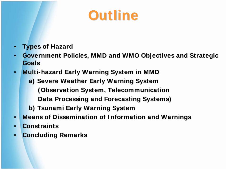
OutlineOutline
•• Types of HazardTypes of Hazard•• Government Policies, MMD and WMO Objectives and Strategic Government Policies, MMD and WMO Objectives and Strategic
GoalsGoals•• MultiMulti--hazard Early Warning System in MMDhazard Early Warning System in MMD
a) Severe Weather Early Warning Systema) Severe Weather Early Warning System(Observation System, Telecommunication (Observation System, Telecommunication Data Processing and Forecasting Systems)Data Processing and Forecasting Systems)
b) Tsunami Early Warning Systemb) Tsunami Early Warning System•• Means of Dissemination of Information and WarningsMeans of Dissemination of Information and Warnings•• ConstraintsConstraints•• Concluding RemarksConcluding Remarks
Types Of WeatherTypes Of Weather--related related And Geological HazardsAnd Geological Hazards
•• Wind Gust from Severe ThunderstormsWind Gust from Severe Thunderstorms•• LandslidesLandslides•• Tropical Storms/Typhoon (Rare occurrence)Tropical Storms/Typhoon (Rare occurrence)•• Earthquake/Tsunami (Rare occurrence)Earthquake/Tsunami (Rare occurrence)•• HazeHaze•• DroughtDrought
Flood in Kota Tinggi, Johore Flood in Kota Tinggi, Johore on 29 December 2006on 29 December 2006
Abnormal weather in Johor Dec 2006/Jan 2007Abnormal weather in Johor Dec 2006/Jan 2007
TSUNAMI
Flood
Severe Wx
Forest Fire
Earthquake/ Volcano
SMS
Fixed Line Phone
MMDMMD’’s Multis Multi--Hazard Early Hazard Early Warning CentreWarning Centre
Multi-Hazard Early Warning Centre (MMD)
Siren
Media
TV & Radio
Multi-hazard Early Warning CentreEarly Warning Centre
Government Policies Government Policies including Eincluding E--GovernmentGovernment
• Focus of e-Government is to enhance the public delivery system through the provision of integrated and efficient ICT solutions to ensure easier and speedier access to Government services, especially by the rural communities.
MMD Strategic GoalsMMD Strategic Goals
• Comprehensively serve the nation‘s needs for weather, climate and environmental information and demands for services;
• Comprehensively serve the nation’s needs for seismological information and tsunami warning services;
• Reinforce authority as the official voice on meteorological and seismological issues and the single official source of severe weather warnings;
• Enhance national, regional and international visibility and establish strong leadership in meteorology and seismology;
• Enhance commercialisation of services;• Enhance and seek synergistic partnership to improve capabilities; • Resolve cross cutting issues to enhance core capabilities.
Goal 1: Comprehensively serve the nation‘s needs for weather, climate and environmental information and demands for services
Strategies :
• Enhance observation program;• Invest in numerical weather, ocean, climate and environmental
prediction models;• Improve customer service and product base;• Work with users of climate information;• Support national needs for sustainable development.
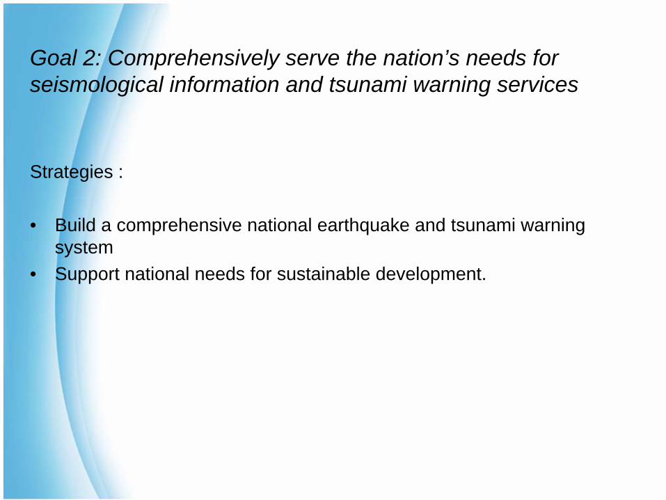
Goal 2: Comprehensively serve the nation’s needs for seismological information and tsunami warning services
Strategies :
• Build a comprehensive national earthquake and tsunami warning system
• Support national needs for sustainable development.
WMO Strategic PlanWMO Strategic Plan
WMO 3 Top-level Objectives :
• To produce more accurate, timely and reliable forecasts and warnings of weather, climate, water, and related environmental elements.
• To improve the delivery of weather, climate, water, and related environmental information and services to the public governments and other users.
• To provide scientific and technical expertise and advice in support of policy and decision-making and implementation of the agreed international development goals and multilateral agreements.
Automatic Weather Observing Automatic Weather Observing Network in MalaysiaNetwork in Malaysia
1. To monitor weather phenomena for forecasting, climatology and research.
2. To have a system with a horizontal spatial resolution of 20 km ×
20 km
1. Since 1995, a total of 180 AWS’s have/are being established over the country
2. Principal Stations (38), measuring 6 basic meteorological elements + RVR, Ceilometer and Wind on runway at airport stations
3. Climatological, measuring 5 elements (including rainfall and hail)
4. Real-time data collection and analysis including distribution to all central and regional meteorological offices
5. Real-time monitoring and maintenance using latest web technologies (http, VPN)
Automatic Stations
AimPrincipal
Auxiliary
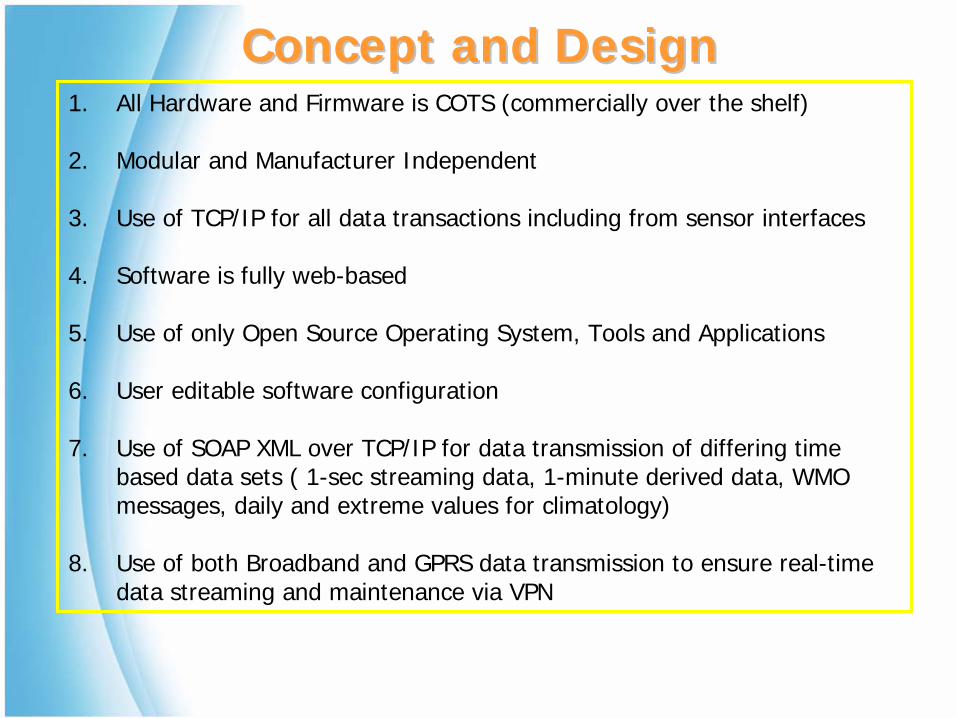
1. All Hardware and Firmware is COTS (commercially over the shelf)
2. Modular and Manufacturer Independent
3. Use of TCP/IP for all data transactions including from sensor interfaces
4. Software is fully web-based
5. Use of only Open Source Operating System, Tools and Applications
6. User editable software configuration
7. Use of SOAP XML over TCP/IP for data transmission of differing time based data sets ( 1-sec streaming data, 1-minute derived data, WMO messages, daily and extreme values for climatology)
8. Use of both Broadband and GPRS data transmission to ensure real-time data streaming and maintenance via VPN
•• Upgrading Internet Access Speed for MMD Headquarters from Upgrading Internet Access Speed for MMD Headquarters from 3 Mbps to 8 Mbps3 Mbps to 8 Mbps
•• Upgrading Internet Access Speed for Regional Forecast Upgrading Internet Access Speed for Regional Forecast Offices from 256 kbps to 1.5 MbpsOffices from 256 kbps to 1.5 Mbps
Use of S&T and ICT to Improve Use of S&T and ICT to Improve Weather and Climate ForecastingWeather and Climate Forecasting
Numerical Weather Numerical Weather Prediction ModelPrediction Model
Numerical Weather Numerical Weather Prediction Products From Prediction Products From
Major CentresMajor Centres
• ECMWF• NOAA• BOM• JMA• UK Met Office• KMA
MMD Capability On MMD Capability On Numerical Weather Numerical Weather
PredictionPrediction
SGI shared-memory, Symmetric multi-processor (SMP) Computing System
HARDWARE Specifications
1. Number of Head Management Node (Blade) per system: 1Number of Blades (Blade Architecture) per system: 64
2. Number of Processors per Blade: 2 processors per BladeSGI Numalink Interconnect between Blades. MPICH is the Message Passing Interface Used.
3. Processor Type: Intel Itanium 2 Dual Core Series 9000
4. Memory: 16Gb DDR2-400 ECC RAM per Blade
5. Direct Attached Data Storage System: 19.2Tb64 300Gb Fibre Channel Attached Hard Disks
6. Intel Fortran and C++ version 9 compilers
SOFTWARE1. Operating System: Suse Linux 10.3
2.Numerical Weather Models: Fifth Generation NCAR / Penn State Mesoscale Model (MM5)Weather Research and Forecasting (WRF)
Experimental Configurations of MM5Experimental Configurations of MM5
Typhoon Initialization Scheme at the Malaysian Meteorological Department
Justification: Lack of sufficient data over ocean presents difficulties in getting accurate representation of storms in the initial conditions for numerical weather models. Typhoon Initialization schemes areused to approach this difficulty.
On Research Mode, implementation is done with help of Scientistsfrom Shanghai Typhoon Institute, China Meteorological Administration.
Implementation is done on the MM5 model. Four Dimensional Variational (4DVar) data assimilation method is used. A synthetic (bogus) vortex is blended with the large scale analysis to improve the initial conditions for the numerical model. The bogus parameter assimilated is the Seal Level Pressure.
Experimental results show that typhoon initialization using the above mentioned method improves the performance of typhoon forecasting in general. Detailed evaluation of the performance of this technique will require a series of quasi-operational experiments.
NWP Models ProductsNWP Models Products
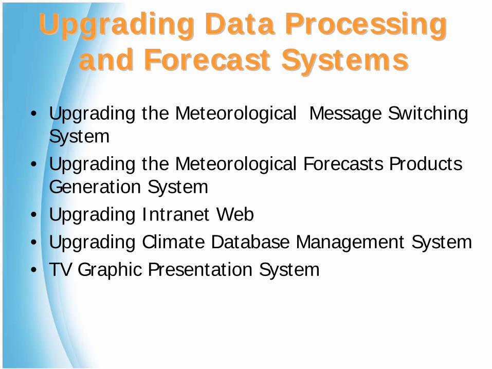
Upgrading Data Processing Upgrading Data Processing and Forecast Systemsand Forecast Systems
• Upgrading the Meteorological Message Switching System
• Upgrading the Meteorological Forecasts Products Generation System
• Upgrading Intranet Web• Upgrading Climate Database Management System• TV Graphic Presentation System
MMDMMD’’s Tsunami Early s Tsunami Early Warning SystemWarning System
Buoy Network
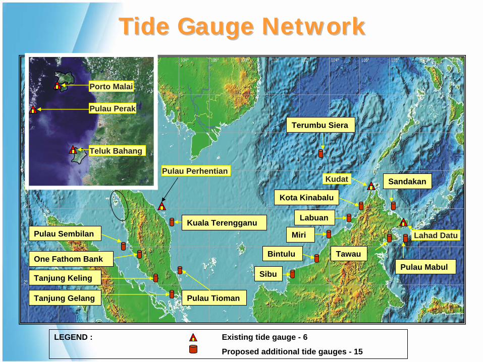
Tide Gauge Network
Tsunami Operations Centre
Warning and Information Dissemination
Coastal Camera Network
Integration
Analysis
Decision Making
TV & Mini Studio
Data C
omm
unication
PTWC / JMA / Other Linkages
Data & Information Gathering Component
Processing Component
Disemmination Component
National Seismic Network
SMS
Telefax
Webcast
Siren / PA
Cell Broadcast
Media Broadcast
Overview of SystemOverview of System
3 more seismic stations will be added in 2009
National Seismic NetworkNational Seismic Network14 Seismic Stations14 Seismic Stations
Broadband Strekeisen
STS-2
ES-T EpiSensor
Data Logger
Digitiser
Power Supply
VSAT
Instrumentation at Seismic StationInstrumentation at Seismic Station
Data Digitizer and Recorder
Sensors
Data Transmitter
Earth Station at
Cyberjaya
Router
VSAT64 kbps
MEASAT
MMD Operation’s Centre for Data Processing and Archiving
Seismic Monitoring Stations Using Satellite Seismic Monitoring Stations Using Satellite Communication Data TransmissionCommunication Data Transmission
Seismic Processing Software Seismic Processing Software and Hardwareand Hardware
2 Sun SPARC Enterprise M 4000 Server features
Hot Swappable :
• 2 Power Supply• Hard Disks• CPU (Each server has 2 boards,
each board has 2 CPU).
1 Sun Netra 240 server for data exchange
A Network of 40 Internationals and 14 Locals 3 Components Seismic Waveforms
Seismic Waves In Real TimeSeismic Waves In Real Time
Malaysia is receiving seismic waveform Malaysia is receiving seismic waveform data from USGS, IRIS, CTBTO, Indonesia, data from USGS, IRIS, CTBTO, Indonesia,
Singapore and Australia through Singapore and Australia through Internet/VSAT in near realInternet/VSAT in near real--time. time.
Malaysia is contributing realMalaysia is contributing real--time seismic time seismic waveform data from its broadband waveform data from its broadband
stations for regional and international stations for regional and international exchange.exchange.
International and Regional International and Regional CooperationCooperation
IndonesiaIndonesia’’s Seismic Network Link to SAATNMs Seismic Network Link to SAATNM
KMBOLAT : 1.1SLONG: 37.3E
FURILAT : 8.9NLONG: 37.3E
GNILAT : 40.1NLONG: 44.7E
AAKLAT : 42.6NLONG: 74.5E
MSEYLAT : 4.7SLONG: 55.5E
RERLAT : 21.1SLONG: 55.7E
DGARLAT :7.4SLONG: 72.5E
PALKLAT : 7.3NLONG: 80.7E
COCOLAT :12.2SLONG: 96.8E
XMISLAT :10.5SLONG: 105.7E
MBWALAT :21.2SLONG: 119.7E
WRABLAT :19.9SLONG: 134.4E
CTAOLAT :20.1SLONG: 146.3E
PMGLAT :10.5SLONG: 105.7E
HNRLAT :9.4SLONG :159.9E
BTDFLAT :1.4NLONG: 103.8E
DAVLAT :7.1NLONG: 125.6E
GUMOLAT :13.6NLONG: 144.9E
CHTOLAT :18.8NLONG: 99.0E
MAJOLAT :36.5SLONG: 138.2E
TPUBLAT :23.3NLONG: 120.6E TWGB
LAT :22.8NLONG: 121.1E
TATOLAT :25.0NLONG: 121.5E
USGS IRIS GEOSCIENCE AUSTRALIA INDONESIA TAIWAN SINGAPORE CHINA
QIZLAT :19.0NLONG: 109.8E
STKALAT :31.9SLONG: 141.6E
Exchange of Near RealExchange of Near Real--Time Seismic DataTime Seismic Data
BUOY 3
BUOY 2BUOY 1
Near Rondo Island Near Rondo Island Installed on 30 Dec 05Installed on 30 Dec 05
South China SeaSouth China SeaInstalled 7 Mac 06Installed 7 Mac 06
Sulu Sea by 2009
Tsunami Buoy NetworkTsunami Buoy Network
Data recorder
Sensors
Data Transmitter
Meteorology
Tsunami Module
Oceanography
National Operations Centre for Data Archiving and Processing
Earth Station (TM)
INMARSAT C
Data Telemetry From BuoyData Telemetry From Buoy
Porto Malai
Pulau Perak
Teluk Bahang
Pulau Perhentian
Kuala Terengganu
Pulau Tioman
Pulau Sembilan
One Fathom Bank
Tanjung Keling
Tanjung Gelang
Sibu
Bintulu
Miri
Labuan
Kota Kinabalu
Terumbu Siera
Sandakan
Pulau MabulTawau
Lahad Datu
Kudat
LEGEND : Existing tide gauge - 6
Proposed additional tide gauges - 15
Tide Gauge NetworkTide Gauge Network
Tolok pasang surutdi Porto Malai, Langkawi
Kudat Port, Kudat, Sabah
HANIMADHO, MALDIVES
GAN, MALDIVES
KO TAPHAO, THAILANGKAWI,MALAYSIA
SABANG,INDONESIA
PADANG,INDONESIA
SIBOLGA,INDONESIA
BENOA,INDONESIA
HANASAKI,JAPAN
OFUNATO,JAPAN
OMAEZAKI,JAPAN
TOSASHIMIZU,JAPAN
NAHA OKINAWA,JAPAN
ISHIGAKI,JAPAN
MALAKAL,BELAU
RODRIQUE,MAURITIUS
PT. LARUE,SEYCHELLIES
MALE, MALDIVESCOLOMBO,SRI LANKA
SITTWE
KO MIANG, THAI
SALALAH, OMAN
MASIRAH, OMAN
DEIGO GARCIA
ZANZIBAR,TANZANIA
MOMBASA, TANZANIALAMU, KENYA
PT. LUIS
TRINCONMALEE
KIRINDA
COCOS ISLAND
MANUS, PNG
YAP ISLAND
LEGASPI, PHILIPPINESMANILA, PHILIPPINES
QUI NHON, VIETNAM
International Tide Gauge NetworkInternational Tide Gauge Network
International Tide GaugesInternational Tide Gauges
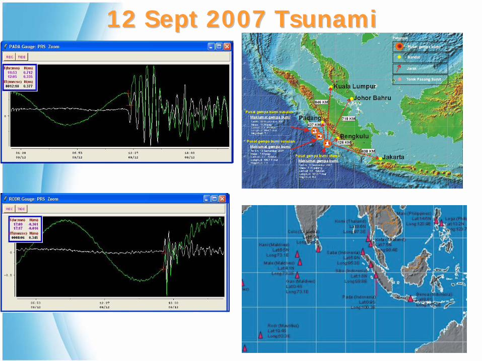
17 July 2006 Tsunami17 July 2006 TsunamiBenoa, Indonesia (8.8ºS, 115.2ºE), Arrival Time: 1009 UTC
Rodrigues, Mauritius (19.4ºS 63.3ºE) Arrival Time: 1509 UTC
12 Sept 2007 Tsunami12 Sept 2007 Tsunami
•• World Meteorological OrganisationWorld Meteorological Organisation•• UNESCO/IOCUNESCO/IOC
Enhanced operational and cost Enhanced operational and cost effectiveness of the National Tsunami effectiveness of the National Tsunami
14 Additional new coastal camera to be installed by 2009
Current CCTV
Coastal Camera NetworkCoastal Camera Network
Dissemination and Dissemination and CommunicationCommunication
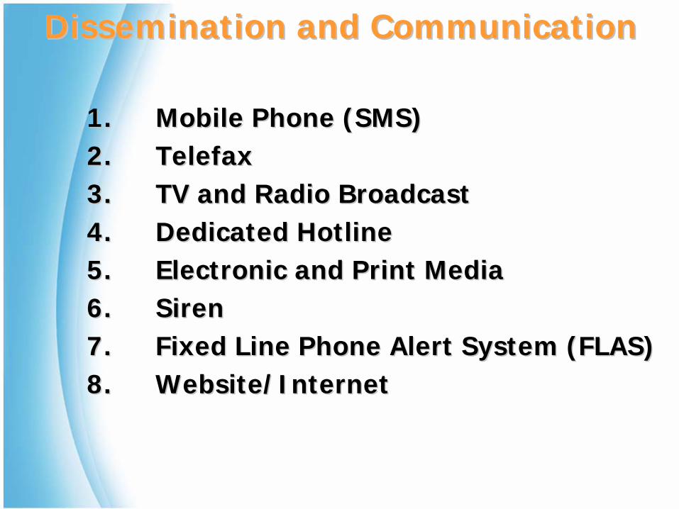
1.1. Mobile Phone (SMS)Mobile Phone (SMS)2.2. TelefaxTelefax3.3. TV and Radio BroadcastTV and Radio Broadcast4.4. Dedicated HotlineDedicated Hotline5.5. Electronic and Print MediaElectronic and Print Media6.6. SirenSiren7.7. Fixed Line Phone Alert System (FLAS)Fixed Line Phone Alert System (FLAS)8.8. Website/InternetWebsite/Internet
Dissemination and CommunicationDissemination and Communication
•• Broadcasting to Selected UsersBroadcasting to Selected Users
•• Information On DemandInformation On Demand
•• SubscriptionSubscription
Mobile Phone SMS ServicesMobile Phone SMS Services
Tsunami Server
Weather Server
7 days weather forecast7 days marine forecastHeavy rainfall warning
SMS ServicesSMS ServicesSend to 15888 Send to 15888 –– Government SMS GatewayGovernment SMS Gateway
LEGEND : Existing Siren - 13
Proposed additional sirens - 10
Pantai Chenang
SandakanKuala Kurau
Pulau Pangkor
Pulau Ketam Pulau Tioman
Kuala TerengganuMiri
Labuan
Kota Kinabalu Lahad Datu
Kudat
Teluk Bahang Kg. Kuala Sg. Muda
Kuala KedahTg. Bunggah
Batu Feringgi
Pasir Panjang
Kuala Teriang
Teluk CempedakSempornaTawauKunak
Siren NetworkSiren Network
Siren at Pantai Chenang, LangkawiSiren at Pantai Chenang, Langkawi
Tsunami Siren Warning SystemTsunami Siren Warning System
• Enable to broadcast alert message in the event of Tsunami to large volume of recipients. 150,000 individuals, in 15 minutes
• Other features that can be supported:Notify targeted community of health hazardAdvance notification of utility outagesForest fire alerts and fire alarmsBroadcast severe weather warnings i.e. flood
• FLAS Benefits:Quick broadcasting of clear, concise warning/alertProvides high volume of contacts/calls capacity at faster and lower costOperates 24X7 all year roundCustomized alert message that suits to the recipients need
Fixed Line Phone Alert SystemFixed Line Phone Alert System
Service Features & BenefitsService Features & Benefits
FLA Features & BenefitsFLA Features & Benefits
• Enable FLAS supports outbound calls to the identified tsunami areas based on the following level of area management:
StatesDistrictsTownsArea
STP
TLDT
STP
ISUP
KLGDT
7 E130 E1
13 E110 E1
IPDT
TCP/IP
IP Network
Remote
STPSTP
MCDT
STPSTP
TCP/IP
Administrator
PUJDAS3rd Floor, PUJ
STPSTP
20 E1
STPSTP
TCP/IP
Remote
TPDAS3rd Floor, TPG
STPSTPKLJ
4E136 E114 E1
KBDT ASDT
STPSTPTP
KUDT TGDT MRDT
FLAS System
PSTNPSTN
22 E16 E1
SJADT PUJDT
14 E1
Taiping - Backup
Putrajaya3rd Floor
1 C7
PCM PCM
RemoteAdministrator
PUJMMD
STPIPSTP
BRK
SPC=3142
SPC=3141 SPC=5142
SPC=5141
Note:
C7 Links: PUJ (8) TP (8)
Voice: 176 E1s
1st Floor, PUJ4th Floor,TP
2222 22
2222
22 2222
Legend:
Media Server
Application/Web/DB Server
Digital Trunk Switch
Element Management System (EMS)
STP Signaling Transfer Point
MMD Malaysian Meteorological Dept.
FLAS Network DiagramFLAS Network Diagram
1 km3 km
2 km
Select Area
Call Blasting Identified AreaCall Blasting Identified Area
ConstraintsConstraints• Financial
A number of the main applications are normally developed exclusive to meteorological services. Hence the cost of implementation of these applications charged by the Contractors tends to be expensive.
• TechnicalICT is evolving at a rate faster than what the staff can absorb and apply effectively.
• Human resource Require a group of innovative and skilled web designers, software developers, programmers and network security and system administrators.
Concluding RemarksConcluding Remarks
• ICT evolution will dictate how meteorological and seismological observations, communications and computations are performed and delivered to clients.
•• Advances in scientific knowledge and computerAdvances in scientific knowledge and computer-- based modelling capabilities in NWP enable based modelling capabilities in NWP enable higher resolution weather prediction models to higher resolution weather prediction models to make better predictions with greater details.make better predictions with greater details.
Concluding RemarksConcluding Remarks
• Rapid changes in technology also increases Rapid changes in technology also increases the challenge to integrating new technologies the challenge to integrating new technologies into the workflow.into the workflow.
• Strengthening telecommunication systems for an effective early warning system.
• Different level of expertise and technical capabilities within the region require capacity building for bridging the gap.