1 A RAPID ECOLOGICAL ASSESSMENT OF THE WAMI RIVER ESTUARY, TANZANIA Field study completed in March 2007 Authors: Elizabeth P. Anderson 1 and Catherine McNally 2 Collaborators: Baraka Kalangahe 3 , Halima Ramadhani 4 , and Hassan Mhitu 5 1 Department of Environmental Studies, Florida International University, USA 2 Department of Natural Resources, University of Rhode Island, USA 3 Tanzania Coastal Management Partnership, Dar es Salaam, Tanzania 4 Park Ecologist, Sadaani National Park, Tanzania 5 Marine Biologist, Dar es Salaam, Tanzania
Transcript
1
A RAPID ECOLOGICAL ASSESSMENT OF THE WAMI RIVER ESTUARY, TANZANIA
Field study completed in March 2007 Authors: Elizabeth P. Anderson1 and Catherine McNally2 Collaborators: Baraka Kalangahe3, Halima Ramadhani4, and Hassan Mhitu5
1Department of Environmental Studies, Florida International University, USA 2Department of Natural Resources, University of Rhode Island, USA 3Tanzania Coastal Management Partnership, Dar es Salaam, Tanzania 4Park Ecologist, Sadaani National Park, Tanzania 5Marine Biologist, Dar es Salaam, Tanzania
STUDY OBJECTIVES AND METHODS ..............................................................9
NATURAL CHARACTERISTICS OF THE WAMI RIVER ESTUARY ................11
VALUED ECOSYSTEM COMPONENTS OF THE WAMI RIVER ESTUARY ....20
CHALLENGES TO MANAGEMENT AND CONSERVATION............................24
CONCLUSIONS AND RECOMMENDATIONS ..................................................27
LITERATURE CITED .........................................................................................29
DATA APPENDIX...............................................................................................30
2
Acknowledgements This study would not have been possible without the financial and logistical support of several institutions and the hard work of many individuals. Thanks to the Coastal Resources Center at the University of Rhode Island for providing the initial impetus for the study and to the Tanzania Coastal Management Partnership for coordination of field work in Tanzania. We are grateful to the staff of Saadani National Park, who facilitated lodging for the field team, as well as access to Saadani Village, surrounding areas, and to the Wami River estuary. Special thanks go to the field team for their enthusiasm and attention to detail during long field days. The results and information presented here are truly the fruits of a team effort. We are grateful to the assistance provided by the boat drivers, land vehicle drivers, and field assistants. Pat McNally was of outstanding help during field sampling, in particular with solving technical problems with field equipment. Lastly, we would like to recognize the generosity with which so many people in the area of Saadani Village shared with us their own observations about the Wami River estuary and fishing practices in the region. We are especially grateful to the many fishermen who took time to talk to us on the beach and allow us to observe their technique and their catches of the day. Others who provided important information include Osvaldo Rock, Mr. Costa, and the staff of the Saadani Safari Lodge. We appreciate your genuine interest in the study presented here and your support for conservation efforts in the estuary.
3
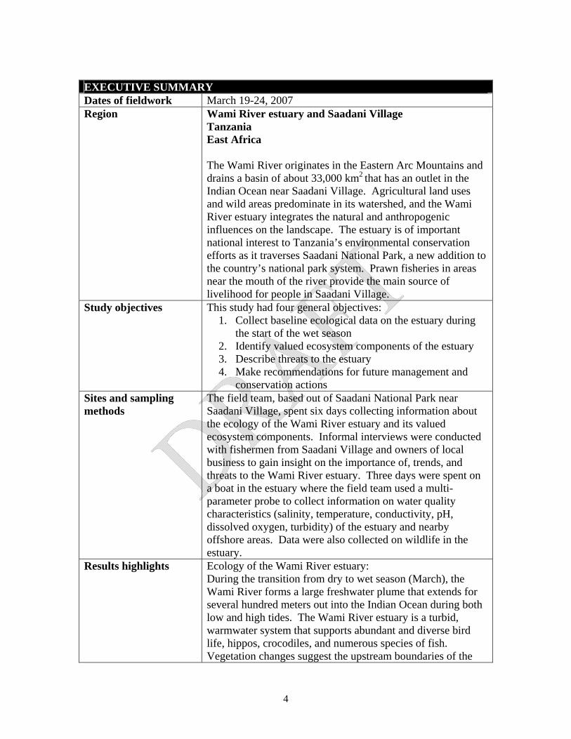
EXECUTIVE SUMMARY Dates of fieldwork March 19-24, 2007 Region Wami River estuary and Saadani Village
Tanzania East Africa The Wami River originates in the Eastern Arc Mountains and drains a basin of about 33,000 km2 that has an outlet in the Indian Ocean near Saadani Village. Agricultural land uses and wild areas predominate in its watershed, and the Wami River estuary integrates the natural and anthropogenic influences on the landscape. The estuary is of important national interest to Tanzania’s environmental conservation efforts as it traverses Saadani National Park, a new addition to the country’s national park system. Prawn fisheries in areas near the mouth of the river provide the main source of livelihood for people in Saadani Village.
Study objectives This study had four general objectives: 1. Collect baseline ecological data on the estuary during
the start of the wet season 2. Identify valued ecosystem components of the estuary 3. Describe threats to the estuary 4. Make recommendations for future management and
conservation actions Sites and sampling methods
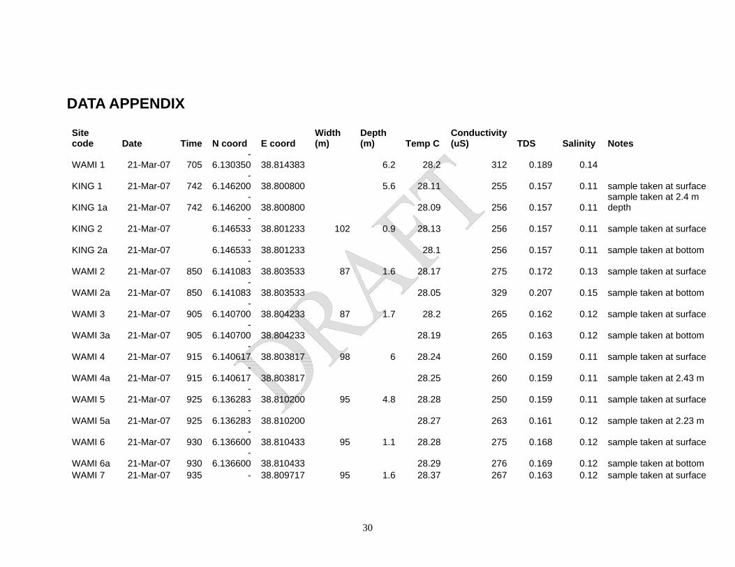
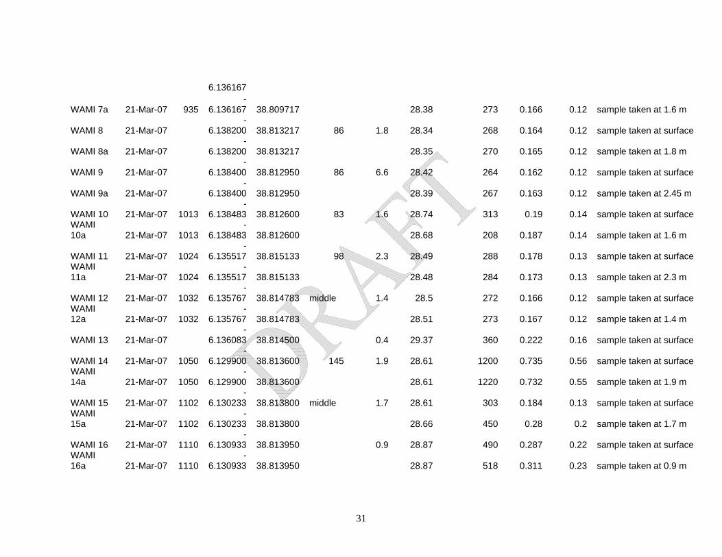
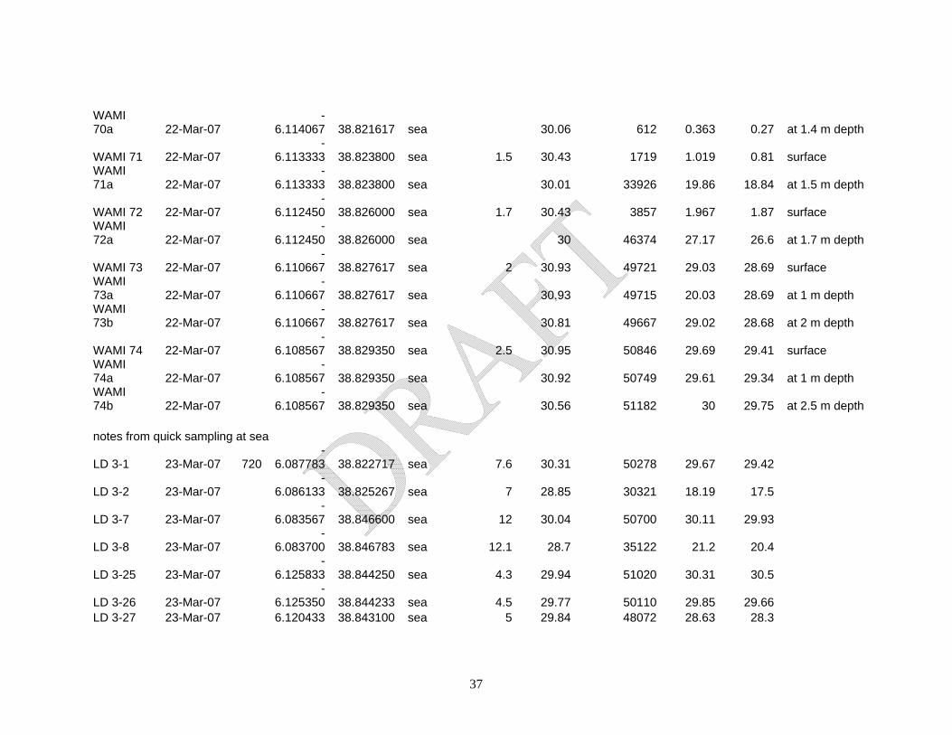
The field team, based out of Saadani National Park near Saadani Village, spent six days collecting information about the ecology of the Wami River estuary and its valued ecosystem components. Informal interviews were conducted with fishermen from Saadani Village and owners of local business to gain insight on the importance of, trends, and threats to the Wami River estuary. Three days were spent on a boat in the estuary where the field team used a multi-parameter probe to collect information on water quality characteristics (salinity, temperature, conductivity, pH, dissolved oxygen, turbidity) of the estuary and nearby offshore areas. Data were also collected on wildlife in the estuary.
Results highlights Ecology of the Wami River estuary: During the transition from dry to wet season (March), the Wami River forms a large freshwater plume that extends for several hundred meters out into the Indian Ocean during both low and high tides. The Wami River estuary is a turbid, warmwater system that supports abundant and diverse bird life, hippos, crocodiles, and numerous species of fish. Vegetation changes suggest the upstream boundaries of the
4
estuary, where mangroves give way to palm forests and then acacia stands. Salinity intrusion to the estuary mainly occurs during dry periods, as reported by local fishermen. Valued Ecosystem Components: The Wami River is very important to the prawn fishery along the coast near Saadani Village and to the newly created Saadani National Park. The river provides key freshwater inputs to coastal areas and its estuary provides nursery grounds for prawns. Prawn fisheries are the main source of livelihood for inhabitants of Saadani Village, and also spark movements in local human populations during peak times of the year. Saadani National Park protects a unique combination of bush / beach / river ecosystems. The Wami River is also an important source of water for park wildlife, especially during dry seasons. International and national tourists who come to the park often take wildlife spotting excursions on the river and report a high level of satisfaction with these trips.
Challenges to management and conservation of the Wami River estuary
The primary challenges to management and conservation of the Wami River estuary, as identified by local fishermen and the field team were:
1. Human population growth in Saadani Village and the subsequent increasing resource demands
2. Overfishing and fisheries-related conflicts between artesanal and commercial fishermen
3. Mangrove destruction 4. Expansion and growing importance of Saadani National
Park as a tourist destination 5. Land use changes and water withdrawals in upstream
areas
5
6
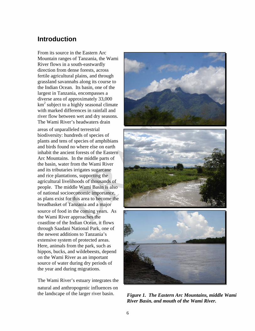
Introduction From its source in the Eastern Arc Mountain ranges of Tanzania, the Wami River flows in a south-eastwardly direction from dense forests, across fertile agricultural plains, and through grassland savannahs along its course to the Indian Ocean. Its basin, one of the largest in Tanzania, encompasses a diverse area of approximately 33,000 km2 subject to a highly seasonal climate with marked differences in rainfall and river flow between wet and dry seasons. The Wami River’s headwaters drain areas of unparalleled terrestrial biodiversity: hundreds of species of plants and tens of species of amphibians and birds found no where else on earth inhabit the ancient forests of the Eastern Arc Mountains. In the middle parts of the basin, water from the Wami River and its tributaries irrigates sugarcane and rice plantations, supporting the agricultural livelihoods of thousands of people. The middle Wami Basin is also of national socioeconomic importance, as plans exist for this area to become the breadbasket of Tanzania and a major source of food in the coming years. As the Wami River approaches the coastline of the Indian Ocean, it flows through Saadani National Park, one of the newest additions to Tanzania’s extensive system of protected areas. Here, animals from the park, such as hippos, bucks, and wildebeests, depend on the Wami River as an important source of water during dry periods of the year and during migrations. The Wami River’s estuary integrates the natural and anthropogenic influences on the landscape of the larger river basin. Figure 1. The Eastern Arc Mountains, middle Wami
River Basin, and mouth of the Wami River.
Spatial and seasonal heterogeneity of environmental conditions in the estuary, such as flow, water depth, and salinity, create diverse habitats for terrestrial and aquatic biota. Within approximately five kilometers of the shore, tropical forests and acacia stands on the banks of the Wami River give way to mangroves, signaling the boundary between freshwater and brackish environments. Although differences in riparian vegetation are clearly marked, within the river channel the lines between saltwater, estuarine, and freshwater environments are much more fluid, and subject to seasonal and tidal influences. During the wet season, the Wami River becomes a giant freshwater plume extending for several hundred meters into the Indian Ocean during both low and high tides. Conversely, intrusion of saline water during the dry season is a phenomenon that influences the Wami River channel, as reported by local residents. The Wami River estuary comprises distinct habitats such as mangrove forests, tidal creeks, and deep channel areas which harbor many species of birds and fish and provide nursery grounds for shrimp. The lives and livelihoods of people living in villages along and near the estuary are tightly linked to the environmental services that the estuary provides. At the mouth of the Wami River lies a small fishing camp, home to about 100 people whose main source of food and income are fish that inhabit the estuary and nearby offshore areas. Just north of the Wami River along the Indian Ocean coastline is Saadani Village, one of Tanzania’s oldest human settlements. Prawn fisheries drive the local economy of Saadani Village. Nearly all men in the village are involved in the prawn fishery in some way and during peak times of the year, the population increases dramatically as fishermen from other parts of the coastline migrate to Saadani Village for the prawn season. Prawns from the areas near Saadani Village garner high prices at markets in Dar es Salaam and other distant cities. The Wami River plays a key role in prawn fisheries: its estuary serves as a nursery ground for several prawn species and local prawn fisherman link freshwater inputs to coastal areas to shrimp production.
7
8
Figure 2. A small fishing camp lies on the north bank of the Wami River just before it reaches the Indian Ocean. The integrity of the Wami River estuary and its ability to provide key ecosystem goods and services have recently come under threat from activities occurring upstream in its basin and from localized impacts on mangrove forests. Heavy loads of suspended sediment in the Wami River reflect the influences of deforestation and intensive agriculture in other parts of the basin. Bare or sparse patches of mangrove along the estuary serve as evidence of local forest destruction for charcoal. Further offshore, during peak shrimp season, commercial boats trawl for shrimp using equipment that facilitates much larger catches than those made by local fisherman employing artesanal methods near shore. This report discusses observations made and data collected in the Wami River estuary and surrounding areas during an intensive week-long reconnaissance trip in March 2007. The information presented here is designed to provide an overview of current natural and anthropogenic influences on the general ecology of the estuary, and highlight the importance of this system to both national and local interests.
Study Objectives and Methods The study described here aimed to characterize the general ecological condition of the Wami River estuary and identify the ecosystem services it provides to local human communities. The study had the following specific goals: (1) collect baseline data on physical, chemical, and biological characteristics of the estuary during the wet season; (2) identify the valued ecosystem components of the estuary to local human populations; (3) describe the past, current, and emerging threats to the estuary; (4) make recommendations for future management and conservation actions. A field sampling campaign was conducted in March 2007 during the transition period from dry to wet seasons. The field team spent three full days on a boat in the estuary and the campaign included collection of quantitative data within the rough boundaries of the estuary, including basic water quality parameters, and vegetation and wildlife surveys. At more than 70 sampling stations, a multi-probe (YSI 556) was used to collect data on water temperature, conductivity, total dissolved solids, salinity, dissolved oxygen, and pH; turbidity of the water was also measured at each of these sites (Figure 3). Where possible, measurements were taken at the water surface and at depth intervals (usually 1 meter) up to 2.5 meters. Basic information about the channel, such as width and channel depth, was also collected along the Wami River. Riparian vegetation along the estuary was placed into general classes: mangroves, palms, woody species; mangroves were identified to the genus level. Occurrence of large wildlife such as hippos was noted during all three days of field sampling from the boat. A formal bird count was conducted from the boat along the Wami River starting from its mouth and continuing until the area near Gama Gate. Birds observed were identified to species where possible using the Birds of Kenya and Northern Tanzania field guide and relying on expertise of the field team.
9
10
Figure 3. Sampling sites along the Wami River and in nearby offshore areas. Qualitative data about the estuarine environment and its importance to human settlements were collected through a series of informal interviews and question-answer sessions with local fisherman, people in Saadani Village, people encountered along the banks of the
11
Wami River, and staff from Saadani Safari Lodge. Questions about perceived threats or recent observed changes in the estuary were also asked of all those interviewed. More targeted questions were asked, depending on the suspected interest of the person being interviewed. For example, fishermen were asked to provide lists of species that were typically captured in the estuary and nearby offshore areas; staff from Saadani Safari Lodge were asked to provide information about the economic value of the intact Wami River and estuary to their business. Information gathered in these interviews serves to complement quantitative data on the ecology of the estuary and the field team spoke with approximately 25 people during the course of the campaign.
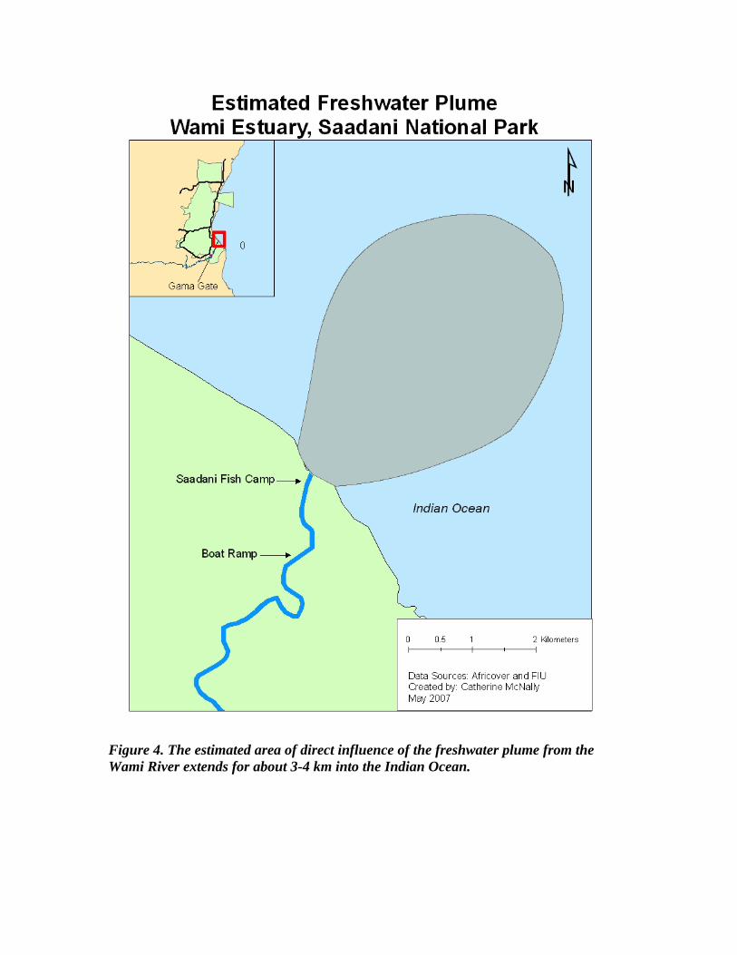
Natural characteristics of the Wami River estuary Spatial and temporal heterogeneity of environmental conditions, particularly salinity, characterize estuarine environments such as that of the Wami River estuary. During the time of this field campaign, water within the river channel was mainly fresh (< 1 ppm saline) and minimally brackish only in areas subject to direct influence of tidal creeks. In fact, low salinity values were common at the mouth of the river and for several hundred meters offshore, indicating that at this time of the year the Wami River functions as a large freshwater plume into the Indian Ocean (Figure 4). A salt wedge, distinguished by a difference in salinity between surface, water column, and bottom waters along a gradient and a common feature of many estuaries, was observed in the offshore areas several hundred meters from the mouth of the river in a northeasterly direction (Figure 4). The side of the salt wedge furthest from the river mouth, where salinity is nearly uniform in the water column, also coincided with a visible line that marked the edge of the freshwater plume, indicating the difference between the more turbid waters of the Wami River and seawater. The plume of freshwater into the Indian Ocean was observed during both high and low tides.
Figure 4. The estimated area of direct influence of the freshwater plume from the Wami River extends for about 3-4 km into the Indian Ocean.
13
Figure 5. The Wami River estuary is mainly freshwater within the river channel and brackish water in nearby offshore areas during the transitional dry to wet season in March.
While saline intrusion into the main Wami River channel west of the river mouth was not noted during this field campaign, it is likely to occur at other times of the year, especially during low flow events. This claim was corroborated by residents of Saadani Village and riparian areas. When asked about the extent of salinity intrusion into the Wami River channel during the dry season, responses ranged from as little as 5 km from the shore to as much as 25 km, or even as far as the location of Matipwili Village. Vegetation changes observed along the banks of the Wami River may also provide information about the extent of seasonal salinity intrusion and tidal creek influences. Marked differences in vegetation occurred in two places. Mangroves, common to brackish water environments throughout the tropics, lined the shore near the river mouth and dominated both banks of the Wami River to a distance of approximately 5 km from the Indian Ocean (Figure 5). A few small acacia-dominated stands and semi-open grasslands were interspersed with mangroves at the western end of this river segment. Differences in species composition within mangrove forests were also evident: Avicennia occurred throughout, while Rhizophora were common to areas closer to the shore and Ceriops and Xylocarpus extended further up the river banks (Figure 5). Moving upstream, date palm trees dominated riparian environments along a ~2 km river segment adjacent to mangrove forests. The difference between these two types of vegetation was clearly marked, and it is suspected that the extent of salinity intrusion occurs somewhere close to the line between mangrove and palm forests.
14
15
Figure 6. Three general transitions between dominant vegetation types occur along the lower Wami River as it approaches the Indian Ocean: grassland / acacia woodlands, palm forests, and mangroves. Other general water quality parameters that were sampled as part of this campaign provide additional descriptive information about the estuary during the transition from dry to wet season. These data also illuminate differences between river and nearby offshore areas of the ocean. The average water temperature of the Wami River during sampling was 28.63 °C, compared with an average water temperature of 30.23 °C in the nearby ocean areas where freshwater from the Wami is mixing with seawater. Marked differences also exist in turbidity between river channel and ocean areas. Average turbidity of water in the river channel was 444 NTUs, due to the large amount of suspended sediment in the river. In mixing zones just offshore, average turbidity values
were 83 NTUs, and declined with increasing distance from the river mouth. The average pH of the Wami River was 7.4; average dissolved oxygen in the river channel was 6.19. The benthic environment is an important component of the estuarine habitat and some information was gathered about bed sediments along the Wami River channel during this study. A modified grab sampler was used to collect sediments but was limited to areas that were less than two meters deep and without strong current. Silty clay comprised bed sediments at WAMI 6 and WAMI 18 sites; silty loam comprised bed sediments at KING 2, WAMI 2, and WAMI 8; and 100% sand was found at WAMI 12, WAMI 15, and WAMI 20 (Figure 3). These categories are based on the widely accepted soil textural triangle. Aquatic biota of the Wami River estuary The Wami River estuary and nearby coastal areas support one of the most important artesanal and commercial prawn fisheries along the coast of Tanzania. This fishery is based on four primary species: Ferropenaeus indicus, Metapenaeus monoceras, Penaeus monodon, Penaeus semisulcatus (Hassan Mhitu, personal communication). The peak season for prawn fishing occurs between March and May, and then there is another smaller peak that occurs between September and December. These seasons correspond with transitional and wet periods in the Wami River Basin. During the peak fishing season, some zonation occurs in the distribution and abundance of prawns in coastal areas north of the mouth of the Wami River. According to local fishermen, near the start of the March-May peak season, the catch is best around Saadani Village. As the season progresses, shifts occur in prawn distribution and abundance. Toward the end of the peak fishing season, catch is best in villages north of Saadani. Local fishermen claim that these shifts are driven by changes in winds, rather than being a response to prawn fishing pressures.
16
17
Figure 7. Jumbo prawns on the beach caught by fishermen in Saadani Village in March 2007. Local fishermen acknowledge the importance of the Wami River estuary and of freshwater flows to the prawn fishery around Saadani Village. Freshwater flows to the estuary transport fresh organic materials; muddy deposits and mangrove forests near river mouths serve as important breeding ground for several species of prawns. The prawn fishery is said to be more productive during wetter years: low flows in the Wami River during the transition and wet seasons are linked to lower shrimp abundance. Four artisanal fishermen from Buyuni Village provided anecdotal information that in 1998, an El Nino year, there were higher catches due to higher levels of precipitation, whereas the drought conditions experienced from 2003 to 2006 resulted in lower than average catch levels. Local fishermen believe that the estuary serves as a nursery ground for prawns and the deeper, middle areas of the Wami River Channel are viewed as particularly important. Juvenile shrimp are thought to inhabit the estuary during the short rains that occur annually in November and December, and migrate back out to the ocean during the longer rains that occur from March to May. Prawn fishing presently does not occur in the estuary, the main reason being fear of hippos and crocodiles rather than a desire to protect nursery areas. In fact, when asked directly, local fishermen stated that the estuary would be a good place to catch prawns, but that this action would require a boat, something to which few people had access.
18
Figure 8. Fishermen on the beach outside Saadani Village. Prawn fishing is usually done by men in pairs using a large seine net. Although the prawn fishery dominates the local economies of Saadani and surrounding smaller villages, estuarine fishes are also important source of food and income in the area, particularly to those people living along the banks of the Wami River. During the sampling campaign, information on fishes was gathered from local fishermen and through observations of recent catches. According to these sources, 16 species of fish are regularly captured in the Wami River estuary and nearby coastal areas (Table 1). Several of these species (papa, kungu, hongwe, and chewa) are thought to be diadromous, moving between sea and freshwater habitats during different periods in their life.
Table 1. List of fish species commonly found by fishermen in the Wami River estuary, according to informal interviews with local fishermen at Gama Gate and at the fishing camp near the mouth of the Wami River. Scientific names were provided by Hassan Mhitu and Halima Ramadhani assisted with interviews.
Hippos and crocodiles are also among the list of aquatic biota commonly found in the Wami River estuary. Hippos move between riparian forests and the main river channel, usually in groups that can sometimes comprise as many as 10-15 individuals. Crocodiles inhabit sandy beaches and shallow shore habitats along both banks of the Wami River. It is likely that crocodiles move longitudinally between the estuary and upstream areas of the Wami River in search of food or in response to flow conditions. Crocodiles have been used as an indicator species of the flow needs of river ecosystems elsewhere (Jimenez et al. 2005). Birds of the Wami River estuary The Wami River estuary harbors abundant and diverse bird life, in large part due to the habitat heterogeneity encountered in riparian areas (Table 2). Wading bird species like herons, storks and egrets are commonly found on sandy beaches along the meandering Wami River or wading through mangrove forests near the mouth of the river. Three species of kingfisher are typically seen perching on snags or riparian vegetation, and there is a large nesting area for Pied Kingfishers at the upstream end of the estuary which comprises a series of holes in the north bank of the Wami River. Weavers, bishops, and bee-eater also inhabit grassy areas and riparian vegetation near the upstream edge of the estuary.
19
Table 2. List of birds sighted in the Wami River estuary during the present sampling campaign. Identification was completed with the assistance of Halima Ramadhani, Elizabeth Anderson, and the Birds of Kenya and Northern Tanzania guide (Zimmerman et al. 1999).
Common name Scientific name Little egret Egretta garzetta Pied kingfisher Ceryle rudis Mangrove kingfisher Halcyon senegaloides Gray heron Ardea cinerea Sacred ibis Threskiornis aethiopicus African spoonbill Platalea alba Black-crowned night heron Nycticorax nycticorax Yellow-billed stork Mycteria ibis White-faced whistling duck Dendrocygna viduata Malachite kingfisher Alcedo cristata galerita Zanzibar red bishop Euplectes nigroventris Great egret Casmerodius albus
Valued ecosystem components of the Wami River estuary Maintaining the ecological integrity of the Wami River estuary is of important national interest to Tanzania and local interest to Saadani and other coastal villages, not only from an environmental conservation perspective but also on the basis of the important goods and services that the intact estuarine ecosystem provides. Fisheries Artisanal prawn and estuarine fisheries support the livelihoods of the majority of people in Saadani Village and the Saadani Fish Camp, and stimulate periodic changes in demography along the central Tanzanian coast. The Saadani Fish Camp, located less than one kilometer upstream of the mouth of the Wami estuary, is home to an estimated 100 people (20 households; 5 per household) throughout the year. According to 2002 census data, there are approximately 1,907 permanent residents of Saadani Village (58%
20
male, 42% female), but during the spring fishing season an influx of prawn fishermen causes the population to increase to approximately 3,000 individuals (Tobey et al., 2005; Tobey, unpublished report). These migrant fishermen typically come from other villages to the north or south of Saadani and stay in Saadani for the duration of the peak prawn fishing season. At the beginning of the high season, the fishermen gather prawns closer to the Wami estuary when the northeast winds predominate. Later in the high season, as the winds shift to a southeasterly direction due to seasonal changes in wind direction, the fishermen migrate to Buyuni to harvest prawns. During the peak season, artisanal prawn fishing is normally conducted daily for a period of three hours at low tide, but during the neap tides the fishermen often fish all day long (personal comm., artisanal fishermen 2007). Fishermen work in pairs and pull a seine net from neck deep water back towards the shore. Once the net is brought on shore, the fishermen sort through the catch, clear away any debris or aquatic vegetation attached to the net, prepare the net, walk back out to neck deep water, and repeat the process. Buyers, some of whom approach the fishermen on the beach or in the village, transport the shrimp in iceboxes by boat or road and sell them in surrounding districts, Dar es Salaam, and Zanzibar. At the time of this assessment, Saadani fishermen were receiving 8000 – 9000 Tsh/kg for Panaeus monodon (jumbo shrimp), 3000 Tsh/kg for tiger prawn, and 1500 Tsh/kg for the white shrimp from the buyers. Incidental bycatch organisms also serve as an important source of income not only for the artisanal fishermen but also the individuals engaged in their processing and selling (Semesi, 1991 as cited in Review of Marine Fisheries for Tanzania, date unknown). As the prawn season progresses, the percentage of jumbo shrimp harvested declines while the percentage of the smaller shrimp species rise. The end of the shrimp fishing season marks the end of any significant economic activity within Saadani Village (Tobey, unpublished report). Other livelihood activities, in particular salt production which takes place at the Coastal Salt Works, provide supplemental income during off-peak times. Commercial prawn fishing in nearby offshore areas of the Wami River estuary is important to national economic interests in Tanzania. Approximately five percent of the total marine fisheries production in Tanzania is from commercial fisheries (Review of Marine Fisheries for Tanzania, date unknown). Currently, the commercial fishing industry is limited to shrimp trawling along a 150 kilometer stretch of the coastline, which includes the area around the Wami River estuary, and small-scale offshore pelagic fishing. The Tanzania Fisheries Department divides the 150 kilometers of coastline into three zones: Zone 1 includes the area between Tanga and the Wami River; Zone 2 includes the area between the Wami and Rufiji Rivers; and Zone 3 includes the area between the Rufiji and Pascale Rivers (Hassan Mhitu, personal communication). The shrimp trawlers must apply for permits from the Fisheries Department. A committee within the Department sets the number of available permits and the amount of allowed catch per permit annually; usually, it grants permits to 24 large trawlers (500 horsepower) and 30 medium size trawlers (100 horsepower) (Hassan Mhitu, personal communication). The trawlers are allowed to fish from 6AM to 6PM from March 1st to November 30th. The prawn fishery is closed to the commercial fleet during the remainder of the year (Dec-Feb) when prawn breeding is known to occur. In the area around the Wami River
21
estuary, trawlers usually do not come until April and stay only until September. The commercial trawlers often fish very close to the shore, which has led to conflicts with the artisanal fishermen. The sandbar at the mouth of the Wami River estuary prevents commercial trawlers from being able to access and fish within the estuary itself. Commercially fished prawns are marketed in other parts of Tanzania and exported internationally. Hotels in Zanzibar and Dar es Salaam comprise the main domestic market. Some of the catch is also sold to Tanzanian residents at Banda Beach near the ferry terminal at Dar es Salaam, but the market cost of 15000 Tsh/kg is far out of reach for the majority of most Tanzanians (Hassan Mhitu, personal communication). The European Union is the main export market for the commercially-fished prawns. In 2004 and 2005, approximately 900 tons of shrimp were exported annually, but only 360 tons were exported in 2006. The reason for the marked decline in 2006 was that it was not economically feasible for the trawlers to fish because of the lower overall shrimp production that year due to the lower quantities of rainfall. Environmental conservation and tourism The Wami River estuary is surrounded by Saadani National Park (SANAPA), the newest addition to the Tanzania National Park Authority (TANAPA) and the only park in East Africa to contain both terrestrial and marine ecosystems. The combination of bush / beach / river is perhaps the most attractive feature that draws national and international tourists. SANAPA was formally established in 2005 and is located approximately 80 kilometers north of Dar es Salaam and approximately 25 kilometers west of Zanzibar. SANAPA encompasses a mixture of forest, woodland, savanna, and mangrove habitats, as well as 70 km2 of ocean with offshore coral reefs and one of the two breeding sites in Tanzania for endangered green turtles (Chelonia midas) (TANAPA 2003). It is home to 40 species of mammals, 27 species of reptiles, at least 20 species of amphibians, an unidentified number of fish and aquatic invertebrates and 266 species of birds (TANAPA 2003; Baldus date unknown). The total area that today comprises SANAPA is 1,137 km2 and is comprised of various areas acquired over more than three decades (Table 3). The first protected area, Saadani Game Reserve, was officially gazetted on January 24, 1969 after consultation with the Saadani village elders. The elders agreed, hoping to gain some revenue from the reserve, and were compensated for the loss of arable land (Baldus, 2001). The establishment of park boundaries in the areas adjacent to the Wami and Madete rivers and the west open area also included discussions with village elders.
22
Table 3. Saadani National Park is comprised of several land areas that were acquired over a thirty year period.
Name Area Date of Acquisition
Saadani Game Reserve 200 km2 1969 Mkwaja South 229 km2 1996 Mkwaja North 207 km2 2000 Zaraninge Forest Reserve 170 km2 2000 West Open Area 115 km2 2002 Ocean Extension 66 km2 2002 Wami North Bank 30 km2 2002 Wami South Bank 22 km2 2002 Madete Extension 23 km2 2002 Razaba Ranch 75 km2 2003 Total Area 1,137 km2
Source: TANAPA 2003 Wildlife conservation and management of unique ecosystems like those found in Saadani National Park are in line with Tanzanian national interests, as is the generation of revenue from tourism. The location of Saadani National Park along a relatively undeveloped coastline and adjacent to terrestrial habitat still supporting large wildlife species makes it a very unique holiday destination. The Wami River is a keystone of the Saadani National Park ecosystem and one of the biggest attractions for international tourists. Currently, tourist numbers are relatively low with approximately thirty to eighty people visiting the park each month. Access is one of the main factors influencing visitation rates and limiting development of the park. Roads to the park are all unpaved and often become impassable during the rainy season. Other modes of transport to the park, such as air travel from other parts of Tanzania and boat travel from Zanzibar, are also only reliable during certain times of the year, mainly the dry season. However, the Tanzania National Parks Authority anticipates a one hundred fold increase in the number of visitors once the district roads are upgraded to all-weather status and an old ferry crossing over the Wami River at Gama Gate is reinstated to facilitate faster access to the park from Bagamoyo and Dar es Salaam. Several lodges and campsites have been established within and around Saadani National Park, the largest being the Saadani Safari Lodge, located just north of Saadani Village. The Saadani Safari Lodge offers a suite of activities to guests, ranging from game drives, to beach excursions, to trips on the Wami River. According to the owner of the lodge, most guests list the Wami River trip as their favorite activity. The trip costs US $40 per person for two to three hours. During the high season, the lodge runs at least one and sometimes as many as three trips per day on the river, with nine passengers per trip. According to the boat driver for the lodge, tourists are most interested in bird watching along the estuary, and many come specifically in hopes of spotting three species: the Mangrove Kingfisher, the Malachite Kingfisher, and the African Fish Eagle.
23
Saadani National Park also plays an important role in the lives and livelihoods of local villagers by protecting the mangrove forests which line the Wami River estuary. Mangroves, which grow between the mean low and high spring tide water levels, provide habitat and breeding sites for many aquatic species, in particular the prawns and fishes that provide a primary source of income and food for villagers. The fruits of certain mangrove species are consumed by villagers for medicinal purposes (e.g., to alleviate stomach ailments) and the wood is utilized for fish traps, poles, roofing lattice, dhows and boat masts, and firewood (Baraka Kalangahe, personal communication).
Challenges to management and conservation Maintaining the integrity of the Wami River estuary in the future will depend on sustainable use and management of natural resources in areas within and adjacent to the estuary, as well as in areas in the greater Wami River Basin. Presently, emerging threats to the estuary include: human population growth of nearby human settlements, increasing importance of Saadani National Park, mangrove cutting, fisheries, and land use change and increasing water withdrawals in upstream areas. The potential consequences of each of these threats are discussed below. Population trends in Saadani Village The human population of Saadani Village has expanded rapidly over the past two decades, and recent trends suggest it will continue to grow in the near future. Between 1988 and 2002, national census statistics calculated a growth rate of 6.1%, compared to a rate of 1.0% in the ten years prior (URT, 2004 as cited in Tobey, unpublished report). This increase in growth rate has been attributed to an influx of residents drawn by prawn fisheries or the salt production, and the creation of Saadani National Park. Expanding human populations result in increased pressures on the resources of the Wami River estuary to support their lives and livelihoods. Increasing importance of Saadani National Park As Saadani National Park grows in popularity and more people visit the area, increasing demand for freshwater goods and services may place stress on the Wami River estuary. For example, during the dry season there may be additional demand for freshwater from the river caused by an increase in the number of tourists visiting SANAPA. More tourists could also mean more boat trips on the river and it is uncertain whether this increased river usage would compromise habitat for hippos and other channel-dwelling speces. These considerations are important for future tourist investment and lodge construction within the Saadani National Park and surrounding areas. Mangrove Cutting The 1990s saw a decline in the overall abundance of mangroves located along the coast between Saadani Village and the mouth of the Wami estuary, as well as the areas located adjacent to the southern banks of the Wami River and estuary (Figure 6). This trend was largely due to illegal cutting of mangroves by villagers and people from outside the
24
25
region for building materials, firewood, and charcoal, as well as mangrove removal for salt making. According to the Participatory Rapid Appraisal (PRA) conducted by the University of Rhode Island’s Coastal Resources Center, the loss of coastal mangroves caused the beach near the mouth of the Wami River and nearby areas to recede considerably and become more susceptible to erosion (Tobey, unpublished report).
Figure 9. Changes in land cover along the Wami River estuary during the period 1990-2000. As a result of increasing pressures on mangroves throughout the country, the Forest and Beekeeping Departments in Tanzania issued a legal mandate in 2003 to protect remaining mangrove forests. In the Wami River estuary, Saadani National Park personnel patrol mangrove areas within the park’s boundaries to reduce the amount of illegal harvesting and littering. Various sources report that mangroves have expanded along beaches and along southern banks of the Wami River since 2000 (PRA citation, local fishermen). Furthermore, many of the artisanal shrimp fishermen interviewed during the rapid assessment noted that since the creation of Saadani National Park there has been a decline in the prevalence of mangrove cutting. Although the threat of mangrove cutting has decreased in recent years, it is essential for Saadani National Park staff to continue their
enforcement efforts to ensure that the demand for charcoal in various areas of Tanzania does not result in the removal of mangroves within and around the Wami River estuary. Overfishing and Fishing Conflicts Overfishing by commercial trawlers and artisanal fishermen, as well as conflicts between these two user groups, are emerging concerns along the coast near the mouth of the Wami River. According to local fishermen, catch rates have declined in the area around the Wami estuary over the past 35 years (personal comm. artisanal fishermen, 2007). In the 1970s, a fisherman could catch over 100 kilograms per day in one meter deep water, but in recent years that number has dropped to less than 10 kilograms per day and working in deeper waters is now necessary to capture prawns (J. Tobey, unpublished report). Several reasons have been given for the noted decrease in shrimp catch. Primary among these are the increase of artisanal fishermen in the area, the smaller mesh size of the nets, lower amounts of rainfall, and the presence of commercial shrimp trawlers that work in the area during the high season (personal comm. artisanal fishermen, 2007). According to local fishermen, commercial prawn trawling boats disturb the ocean floor, catch large quantities of bycatch, and impact artisanal fishermen by interfering with their set gill nets and lowering the quantities of available catch in nearshore waters (J. Tobey, unpublished village report). Many of the artisanal fishermen interviewed during this assessment also commented that the commercial trawlers fish in very shallow water and use gear that tears up the sea bottom and causes turbidity. Furthermore, they claimed that when the trawlers are absent, some fishermen catch as much as 40 to 50 kilograms in a day, although 10-15 kg/day is more likely (personal comm. artisanal fishermen, 2007). Some of the other reasons given for the decrease in shrimp harvest are the cutting of mangroves and the use of poisonous herbs/roots (utupa) for fishing. Clear cutting of mangroves removes important breeding habitat for shrimp and allows water temperatures to increase, which prompts migration out into the ocean. Since the creation of Saadani National Park, mangrove cutting and the use of poisonous herbs/roots for fishing have decreased because there are extension officials that inform the fishermen of the laws and the penalties for breaking them (personal comm. artisanal fishermen, 2007). Changes in the quantity and quality of freshwater delivered to the estuary could also affect shrimp abundance and catch by artisanal fishermen. Survival and growth of juvenile shrimp in the estuary is influenced by salinity and temperature, both of which are parameters strongly related to freshwater flow from upstream areas. Shrimp abundance may fluctuate over time on the basis of inter-annual variability in these conditions. Maintenance of the estuary and river channel in the most natural state possible will create conditions that favor long-term survival and health of shrimp populations. Upstream impacts The location of the Wami estuary as the ultimate receiving water body of the 33,000 km2
Wami River Basin makes it susceptible to upstream activities that affect water quantity and water quality. Small-scale water abstractions occur throughout the basin, but currently there are only three large-scale projects that withdraw water from the Wami and other rivers in the basin: Chalinze Water Supply, Mtibwa Sugar, and Dakawa Rice. The
26
closest of these to the estuary is the Chalinze project, located at the bridge crossing over the Wami River on the road from Chalinze. The project currently withdraws 800-1000 m3 of water per day, but the design capacity of the pumping station is 7,200 m3 /day. There are also plans for major agricultural expansion in the Wami River Basin and surrounding areas near Morogoro, and in the coming years a substantial portion of Tanzania’s food may be grown in this region. Consequently, the amount of water withdrawn from the Wami and other rivers for irrigated agriculture is likely to increase, leading to a decrease in the amount of freshwater delivered to the estuary. Land use conversion from natural to agricultural areas may also influence water quality conditions in the Wami River estuary. Increases in suspended sediments and nutrient concentrations are probable consequences of agricultural expansion in the basin.
Conclusions and Recommendations This report is designed to provide an overview of the ecology of the Wami River estuary and to articulate the importance of the estuary to the lives and livelihoods of nearby human settlements in general terms. It is intended to be used by those people interested in further studies of the Wami River estuary, and as a springboard for developing guidelines for management and conservation of the estuary at present and in the near future. Present management recommendations for the Wami River estuary fall into two general categories: (1) filling important gaps in scientific information about the estuary; and (2) reducing current threats to the estuarine ecosystem. While this assessment provided an initial overview of environmental conditions in the estuary, data on physical, chemical, and biological characteristics may only be representative of estuarine conditions during the time of the year when information was collected. In order to best characterize temporal variation of environmental conditions in the Wami River estuary, it will be necessary to repeat sampling of the estuary during other times of the year, and in particular during dry periods. With respect to current threats to the Wami River estuary, some of those mentioned in the previous section, such as land development and water withdrawals in upstream areas or conflicts between trawlers and village fishermen, will need to be addressed within the framework of integrated water resources management or national policies. However, other more immediate, localized threats to the integrity of the estuary can be addressed in relatively simple ways. For example, bycatch from artisanal and commercial prawn fishermen often includes many different species, and is often left on beaches or on boats, where animals die on the beach and then are washed away with high tides; efforts could be made to separate bycatch and return animals to the oceans alive. Continued patrolling of the estuary by Saadani National Park staff is another important component to overall environmental management and reduction of current threats to the estuary. Actions taken over the next five years in Saadani Village, in Saadani National Park, and in upstream areas of the Wami River Basin have the potential to substantially affect the ecology of the estuary as well as the goods and services it provides to local human
27
populations. In Saadani Village, encouraging fishermen to collect information on prawn catches and observed trends in prawn abundance, distribution, and habitat availability will provide information about the status and sustainability of the prawn fishery. In Saadani National Park, sustainable tourism and consideration of water resources as an integral component of the park will be important components of future park management strategies. With respect to the Wami Basin as a whole, if maintenance of freshwater flows to the estuary is important to stakeholders, then water management tools such as environmental flow recommendations can be applied to balance freshwater needs for humans and nature, and provide guidelines for future water resources development.
28
29
Literature Cited Baldus, R.D., K. Roettcher, and D. Broska. 2001. Saadani: an introduction to Tanzania’s future 13th National Park. Tanzania Wildlife Discussion Paper No. 30: Rolf D. Baldus and Ludwig Siege (Eds.) Baldus, R.D. undated. Checklist of Birds of Saadani National Park. In www.wildlife-baldus.com/download/SaadaniBirdChecklist.pdf Blosch, U. and F. Klotzli. 2002. The vegetation of the Saadani National Park and possible conservation and management strategies. Tanzania Wildlife Discussion Paper No. 33: R.D. Baldus and L. Siege (Eds.). Review of Marine Fisheries for Tanzania, undated. Annex 1.1: Understanding Fisheries Livelihoods and Constraints to their Development, Kenya & Tanzania. Semesi, A.K. 1991. Management Plan for the mangrove ecosystem of Mainland Tanzania, Vol. 3. Mangrove Management Plan of Bagamoyo District, Ministry of Natural Resources and Tourism/NORAD. Catchment Forest Project 1991. TANAPA, 2003. Saadani National Park, Management Zone Plan Environmental Impact Assessment. TANAPA/Department of Planning and Project Development. Tobey, J. E. Torell, M. Thaxton, B. Crawford, B. Kalangahe, A. Issa, and N. Madulu. 2005. HIV/AIDS and Threats to Coastal Biodiversity in Tanzania Cross-Sectoral Dimensions of HIV/AIDS, Gender, and Population Dynamics in Critical Areas. Coastal Resources Center, University of Rhode Island. Tobey et al., unpublished report. Results of the Participatory Rapid Appraisal (PRA) conducted by the Tanzania Coastal Management Partnership (TCMP) and the Coastal Resources Center (CRC) in January 2005. Treydte, A.C. 2004. Ecosystem studies on the former Mkwaja Ranch and the Saadani National Park between 2001 and 2004. Tanzania. Tanzania Wildlife Discussion Paper No. 42: Rolf D. Baldus (Ed.). United States Forest Service, 2007. Wami River Resource Assessment: Rapid Assessment of the Interdependence of the Wami River to the Ecosystems and Biodiversity of Saadani National Park, United Republic of Tanzania. Zimmerman, D.A., D.A. Turner, and D.J. Pearson. 1999. Birds of Kenya and Northern Tanzania. Princeton University Press, New Jersey.