1 Thinking about Public Space and Automobile Traffic Culture -In the Context of Traffic Safety in the Age of Autonomous Driving- Katsutoshi OHTA Professor Emeritus, The University of Tokyo (2017.11.17)
Transcript
1
Thinking about Public Space and Automobile Traffic Culture -In the Context of Traffic Safety in the Age of
Autonomous Driving-
Katsutoshi OHTA Professor Emeritus, The University of Tokyo
(2017.11.17)
2
Contents
1. Introduction:Background and viewpoint
2. Concepts and the Context: Public space and transport behavior
3. Transport Behavior in Public Space: Research review
4. Theory of Street Planning and Design: Engineering standards and manuals
5. Toward the Future: Issues and proposals
3
1. Introduction
• Background:Behavior of the people in public space has changed very much recently with the carrying items (smartphones, carrying bags etc.) together with increasing numbers of older people and mothers with children. Some dangerous situation are often observed on our streets. *Pokemon GO fever.
• Stuns:Discuss street as the major public space here in the context of traffic safety and transport culture from urban transport planning perspective.
• Approach:Review the behavior studies , planning /design manuals and policies of the streets in Japan, England and USA in accommodating public space functions. Identify issues of current engineering approach and propose a way to design streets as a public space based upon quantitative measurements, taking into consideration of technological innovation of autonomous and connected vehicles(Auto Sapiens).
4
2. Concepts and the Context:
Public space and transport behavior
• Public Space of road transport:
・Subject: Public space accessible by general public in transport. Street
(urban roads), transport squares, station plaza, bus terminal ,parking area and other transport infrastructure(links and nodes).
・Land ownership: Public land(ROW) , some private lands of transport operators and some others are used for transport. Besides street’s surface, the underground and the overground spaces are used for transport. Also, front space of building and space between buildings are
recognize as public space and restricted their free uses.
・ Behavior of transport participants( persons and vehicles) with their purpose on the streets focusing on safety and security aspects. The use of streets reflects local conditions and transport culture.
5
3.Transport Behavior in Public Space : Japanese studies of transport space
• Modernologio (1930, Wajiro Kon): Observation and analysis of
present things and situation (behavior, customs). *Modernology ⇒ Archaeology on the past things and history
Kennji Ekuann et al:Study on the meanings of life focusing on the history of people’s life based on outdoor observation to discover the problems and issues.
• Life-oriented Behavioral Studies (2013,Zhang Junyi, et al):
Study on people’s life and the related situations from the viewpoint of human behavior.
-Interdisciplinary studies have been advanced. Related academic fields are folklore, cultural anthropology, ethology, architecture history, and industrial design, then recently transport planning/engineering, psychology and behavioral economics.
6
Front Cover of KOGENGAKU (Modernologio)
ーKon Wajiro,1930 ー
7
Transport in a Station Plaza (Hirosaki station)
8
Walking Course of a Modern Girl
Analysis of Vehicle Behavior on Street: A Study of Car Body Language (IATSS, 1991)
・Background: Driving behavior is different by region. Various spontaneously developed local rules or manners using body(voice, face expression and hands) and equipment(lights and horns) are found. But, some dangerous cases of these CBL should be modified.
-Function of CBL: Information exchange of the traffic situation, intention of the driver/greetings(takeover, tailgating, ‘After you’ and ‘ Thank you’.
-Intentional/Explicit vs Unintentional/implicit CBL. 1 or 2 way CBL
-Local CBL communication ability( understanding and responses) depends on driver’s skills/experiences, age and gender.
-Big risks of confusion, embarrassment and misunderstanding for new comers/visitors other than local peers.
*CBL is unofficial local Vehicle-to-Vehicle(V2V) communication rules.
**Body language: A form of nonverbal communication using conscious or unconscious gestures and movements.
9
Examples of Car Body Language
Younger drivers tend to communicate more using various vehicle equipments. They are more selfish and egoistic than older drivers. Source: Masaki Aoki(Pl.), A STUDY OF CAR BODY LANGAGE. IATSS. 1991.3
10
Transport Behavior in Public Space: Theories and Studies
Proxemics: Edward T.Hall, THE HIDDEN DIMENSION,1966
・Animal ethology, cultural anthropology: Concepts of distance coordination such as Spacing and Territory are applied to understand
human behavior in public space. 4 Distance zones/Territories Model:
-Intimate zone: Physical contacts with 5 senses(~46cm)
-Personal zone: A small protective space or ‘bubble’(46~122cm)
-Social zone: Outer area of ‘the limit of (direct) domination’.
Non-personal contact area. (1.2~3.7m)
-Public zone: Well outside of personal involvements. Possible to take evasive or defensive action(3.7~7.6+m)
*Useful concepts to understand behavior based on communication(P2P).
Road traffic safety: Identification of each transport participants and their
communication(P2V and V2V) of their real time distance zones are useful.
11
12
4 Theory of Street Planning and Design: Japanese standards and manuals
• Engineering standards for Street: Road Structure Law specifies alignment, width ,number of lanes and cross section based on design traffic volume, design speed etc.
―Developed based on vehicle traffic. At first, Street Structure Law(1919-1958) was specified separately. Consideration on pedestrian and bicycle traffic has improved since 1970’s.
・ Functions of Street: Transport Function(traffic function and access function) and Space Function(formation of urban skeleton and landscape, securing of environment, accommodating utility facilities and community building). Street as a public activity space is considered in space function. Under and over ground space is also used for transport. *Different from ROAD.
13
Function Effects
Traffic function
Transport services for vehicles, pedestrians, bicycles etc.
Improved safety, reduction of traffic congestion, travel time/cost, energy use and pollutions
Access function
Access to land, buildings and facilities along the street
Improved platform for regional development and life, promotion of land use
Space Function
Formation of urban skeleton・ landscape, securing good envi-ronment ,prevention of disaster damage, accommodation of public utility facilities, community building
Improved image of the city, formation of urban landscape, space for greening, ventilation and lighting, escape route, space for fire fighting and checking of fire spread, accommodation of subway and utility facilities(electricity, telephone, gas and water ), improved neighborhood contacts
Source: Niitani and Harata、URBAN TRANSORT PLANNING 3rd edition. 2017
Function of Street: Japanese case
Transport Function
14
Concepts of Street Planning and Design
-UK- TRAFFIC IN TOWNS (Buchanan Report), 1963 The Buchanan Principles:
1.Clear separation of urban rooms (Environmental Areas) from corridor (Distributors). 2. Functional hierarchy of urban distributors ( Primary, District, and Local distributors, and Access roads). 3. Three basic factors: The Accessibility and Living Environment are in trade- off, but they can be improved by infrastructure investments with Costs.
◆ It has widely accepted especially in planning new towns and residential developments in Japan and European countries. It proposed separation of vehicle traffic from pedestrians, but consideration of total transport modes ( public transport and bicycles) are limited. * Buchanan’s recollection: People have chose Accessibility, we have failed to improve our Environment. ** Motor vehicle is ‘the Beloved Monster’. AV?
15
・The Buchanan Report (HMSO,1963)
1958 1963
Car : “The beloved monster” ⇒ 2013 Even, today? YES.
16
・The Buchanan Principles
A. Urban room and corridor B. Environmental areas and distributors
Primary distributors District distributors Local distributors Environmental area boundaries
17
Function of Street: A new approach in England ー LINK AND PLACE
Source: Peter Jones et al, ‘LINK AND PLACE’ : A Guide to Street Planning and Design, 2007.
18
Street Type in Link/Place Matrices (Example)
Source: P. Jones et al, LINK & PLACE. 2007
19
The Coverage of the Link/Place Street Plan
a. Conventional scope of a road plan
b. Conventional scope of a land use plan
c. Scope of a Street Plan
*Note: Public space includes public land (street ROW ) plus privately owned land/space accessible or visible from the street (front areas of buildings , space between buildings and others). Source:Peter Jones et al, ‘LINK AND PLACE’ : A Guide to Street Planning and Design. Local Transport Today, 2007.
Case Example: London Mayor’s Proposal
Greater London Authority, ”Draft Mayor’s Transport Strategy” 2017
―A recent long-term proposal on London’s transport strategies ( Target
year 2041, over the next 25 years) by Mayor Sadiq Khan
‘The Healthy Street Approach’ with the following themes:
1. Healthy streets and healthy people-Less traffic and more active travel.
2. A good public transport experience-More pleasant, fast and reliable public
transport service with the expanded network. More affordable and accessible services.
3. New homes and jobs-Sustainable travel in regeneration and new developments.
*Targets: Traffic congestion ⇒ Quality of Life(Environment)/Health.
Reduction of vehicle trips(36% in 2015 to 20% in 2041).
20
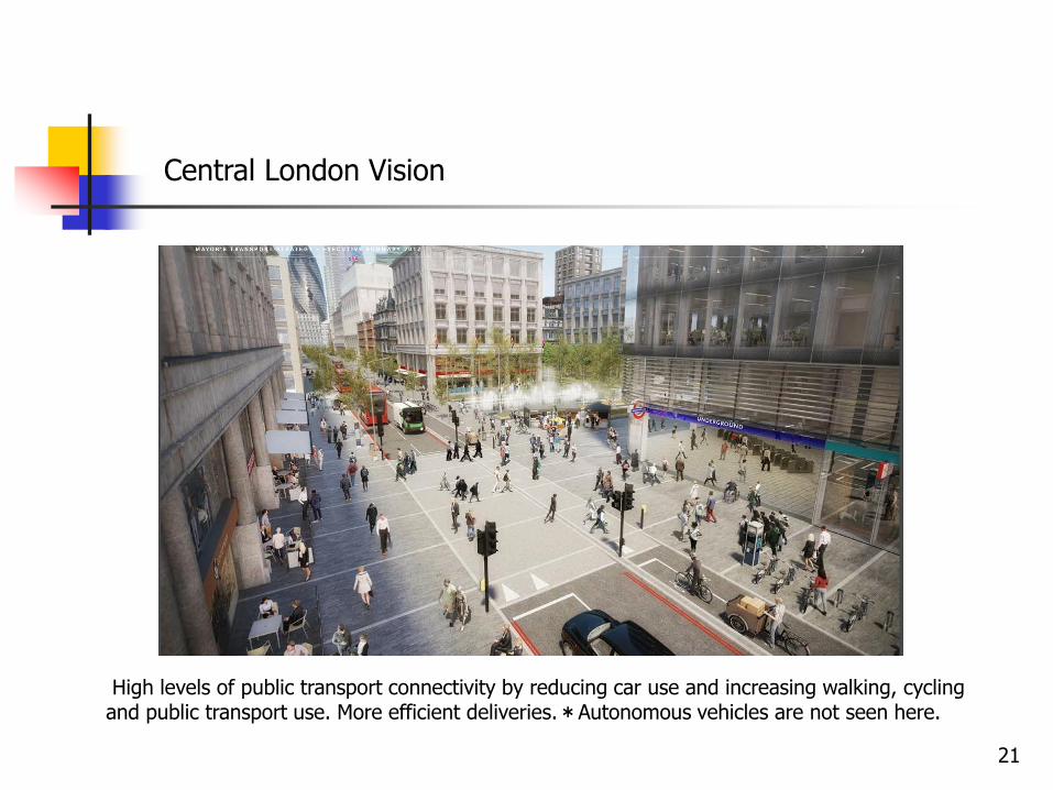
Central London Vision
High levels of public transport connectivity by reducing car use and increasing walking, cycling and public transport use. More efficient deliveries.*Autonomous vehicles are not seen here.
21
Concepts of Street Planning and Design ― USA ―
NATCO(National Association of City Transportation Officials),
URBAN STREET DESIGN MANNUAL, 2013
―Design principles and strategies for world-class streets of 21st century.
Five Principles of Urban Street design: ①Street are public spaces, ②Great streets
are great for business,③Design for safety,④Street can be changed,⑤Act now!
Street Function: ①Traffic flow and access, ②Multi-purpose public space
Sidewalk: 4 zones are identified for design from the building to the curb
①Frontage Zone, ②Pedestrian Through Zone, ③Street Furniture/Curb Zone,
④ Enhancement/Buffer Zone
* Besides traffic function, public space function is focused. Planning covers privately owned land such as building frontage area as a public domain. **NATCO’s President is the former New York City’s Transportation Commissioner, Janette Sadik – Khan(2007-2013), who promoted pedestrianized area of Times Square and expansion of the cycling network under former Mayor Michael Bloomberg. 22
Design Domain of Sidewalk Zones in NATCO’s Manual
① Frontage Zone ③ Street Furniture/Curb Zone ② Pedestrian Through Zone ④ Enhancement/Buffer Zone Cf. Austin City’s Draft Street Design Guide(2017) identifies three street zones, Pedestrian Zone, Bicycle and Street Edge Zone, and Motor Vehicle and Transit Zone. Pedestrian Zone includes building setbacks. 23
New York City, STREET DESIGN MANNUAL, 2nd ed. (2015)
Supplementary manual of conventional ones(MUTCD, AASHTO’s Green
Book ), showing design guidelines, policies and the management process.
Background: ‘ A more vibrant public realm, with safety, health and
economic benefits for all ’
*Succeeding a bold attempts of street’ redesign of the former Mayor.
Design Goals & Principles: ① Safety, ② Balance of local access and mobility,
③ Design for context, ④ Street as public spaces, ⑤ Sustainability and resiliency,
⑥ Cost-Effectiveness.
Recent Manual of Street Design: New York City
24
A Street Scene of New York City in the Early 20th Century -Street served as the front yards and public squares of citiesー
Source: New York City DOT, STREER DESIGN MANNUAL, 2015.
-Design standards for each road categories are specified by the technical standard laws and manuals.
-Basic units:Vehicle size and other characteristics are defined for the
street planning by standard design vehicles of motorcycle, car, truck and et al. Number of lanes and road width are decided by future traffic volumes per hour in pcu(passenger car unit). Similar approach is used for walkways.
・Recent Trends in Big Cities : All modes and inclusive design
Renewed focus on bicycle and pedestrian from health and environmental problems. Policy shifts to restraint of car use and sustainable transport. Road space reallocation, complete street , road diet, traffic calming, complete street, shared space and other key words show that redesign of streets have become new trend.
26
Traffic Behavior on Streets:
Approach from Traffic Engineering
・Fundamental Diagram of traffic flow
-Relations of traffic volume and the service level(speed), used in
deciding numbers of lanes, road width, alignment and cross/vertical-sectional structure and other elements of the road.
-Similar approach is used in designing walkway and cycle paths.
* The approach is useful for traffic function of streets, but difficult to analyze stationary traffic(parking and loading) and mixed traffic.
* For the quantitative analysis of space function of streets, appropriate measures are limited, besides the availability and size.
** Potential applicability of Proxemics: Ideas of distance based zones is useful for the description and analysis of traffic accident risk as well as potentials of human contacts. Connectedness of transport participants(street users) are analyzed as P2P,P2X communication.
27
Application of Proxemics Theory to Street Planning and Design
・Transport Function: Efficient provision of stationary/moving
transport services as derived demand. Safe and comfortable travel with less cost and time.
・Safety: Based upon mutual recognition and communication of all
transport participants, crash prevention/evasion, crash management
and other measures should be redefined by Proxemics in spatial domain.
*Each transport participant(person, cycle, vehicle, AV etc.) should show its identity(species, performance, intention of street use) by passive ID( respond only) or active ID( dispatch its intention as well).
・Space Function (Street activities):Time-space activity services as primary demand. Maximize safe and pleasant time-space experiences, and human contacts/meeting chance.
* Consideration of all street users’ needs: Provision of social zone and public zone based upon P2P(Peer to Peer),P2X connectivity.
28
Redefining Basic Units for Street Planning and Design -TSO(4 dimensions, ㎥・hour/use)ー
Basic Measures/Units Conventional measures such as traffic volumes(vehicles in pcu or person/hour) for traffic function and area(㎡) for space function are not appropriate to quantify mixed traffic and various activities on the street.
・Proposals: In quantifying various behavior of Transport Participants, their ‘slot’ in terms of distance zones based on Proxemics should be useful.
-Time-Space Occupancy TSO(Unit: TSO/use in ㎥・second/hour):Redefined capacity of public space applicable to street design, cost allocation, reservation of use(available ‘slot’ management).
-Time-Space Exposure (Unit: time/use in seconds): Environmental/health
risk(Exposure time per day) and personal contact chance( Number of chances per exposure time) can be quantified using TSO.
29
1. Street’s space function is also important. *Beside traffic function
2.Public space extends to public land including frontage areas of buildings and space between buildings.
3.Design and use of streets reflect local life, history and culture.
4.Conventional planning and design are mainly based on theories and standards of vehicle traffic, limited consideration of other modes and activities on the street.
5.People’s behavior has changing with innovations in IT and vehicle technology, and safety remains an issue. The trend is toward restraining vehicle use due to people’s valuing health and the environment.
6.New extended theories and basic quantitative indicators related street development and use are necessary. E.g. Proxemics ,TSO etc.