THIRD FIVE-YEAR REVIEW REPORT FOR BENNINGTON LANDFILL SUPERFUND SITE BENNINGTON COUNTY, VERMONT Superfund Records Center SITE: v LC BREAK: 3 OTHER: pro^° September 2014 Prepared by U.S. Environmental Protection Agency Region 1- New England BOSTON, MASSACHUSETTS -"f9- l James T. Owens, III, Director Date .Office of Site Remediation and Restoration
Transcript
THIRD FIVE-YEAR REVIEW REPORT FOR
BENNINGTON LANDFILL SUPERFUND SITE BENNINGTON COUNTY VERMONT
Superfund Records Center SITE v LC BREAK 3 OTHER
pro^deg
September 2014
Prepared by
US Environmental Protection Agency Region 1-New England
BOSTON MASSACHUSETTS
-f9- l
James T Owens III Director Date Office of Site Remediation and Restoration
2014 FIVE-YEAR REVIEW BENNINGTON LANDFILL SUPERFUND SITE
TABLE OF CONTENTS
EXECUTIVE SUMMARY vii
I INTRODUCTION 1
II PROGRESS SINCE THE LAST REVIEW 2
III FIVE-YEAR REVIEW PROCESS 3
IV TECHNICAL ASSESSMENT 7
V ISSUESRECOMMENDATIONS AND FOLLOW-UP ACTIONS 11
VI PROTECTIVENESS STATEMENTS 11
VII NEXT REVIEW 11
APPENDICES
APPENDIX A EXISTING SITE INFORMATION APPENDIX B PRESS RELEASE ANNOUNCING FIVE-YEAR REVIEW APPENDIX C TABLES APPENDIX D FIGURES APPENDIX E RECORD OF INTERVIEWS APPENDIX F SITE INSPECTION LOG AND PHOTOS APPENDIX G AMBIENT MONITORING TRANSER LETTER APPENDIX H GRANT OF ENVIRONMENTAL RESTRICTIONS AND RIGHT OF
ACCESS
iii
LIST OF ACRONYMS
ARAR Applicable or Relevant and Appropriate Requirement
CERCLA Comprehensive Environmental Response Compensation and Liability Act
EPA United States Environmental Protection Agency
CFR Code of Federal Regulations
CWA Clean Water Act
FYR Five-Year Review
GAC Granular activated carbon
HAAS Hazardous ambient air standards
IC Institutional control
IPC Influent pump chamber
LCTS Leachate collection treatment systems
LTMP Long-term monitoring plan
MCL Maximum Contaminant Level
MCLG Maximum Contaminant Level Goal
MW Monitoring well
NCP National Contingency Plan
NFA No Further Action
NPL National Priorities List
NTCRA Non-Time Critical Removal Action
OampF Operational and functional
OampM Operation and Maintenance
OU Operable Unit
PCB Polychlorinated Biphenyls
PCE 1 Tetrachloroethylene
PCOR Preliminary Close-Out Report
PRP Potentially Responsible Party
RA Remedial Action
RAO Remedial Action Objective
RD Remedial Design
RIFS Remedial InvestigationFeasibility Study
ROD Record of Decision
TAL Target analyte list
TCA 111-trichloroethane
TCE trichloroethylene
iv
TCG Target Cleanup Goals
VGES Vermont Groundwater Enforcement Standards
VOC Volatile Organic Compound
VT DEC Vermont Department of Environmental Conservation
VT DOH Vermont Department of Health
VTGWES Vermont Groundwater Enforcement Standard
UgL Microgram per Liter
v
EXECUTIVE SUMMARY
This is the third Five-Year Review (FYR) for the Bennington Landfill Superfund Site (Site) located at Houghton Lane Bennington VT The purpose of this FYR is to review information to determine if the remedy is and will continue to be protective of human health and the environment The methods findings and conclusions of these reviews are documented in the FYR Reports In addition FYR Reports identify issues found during the review if any and recommendations to address them
The Non-Time Critical Removal Action (NTCRA) for the Site included excavation and on-site disposal of contaminated soils a multi-layer landfill cap drainage controls passive gas vents an interceptor trench for surface and ground water groundwater and leachate collection and on-site treatment long-term monitoring and institutional controls A 1998 Record of Decision (ROD) made the final remedial decision that no further action (NFA) beyond the NTCRA was required at the Site to protect human health and the environment The Site achieved construction completion on June 30 1999 In the ROD EPA also determined that it would conduct FYRs of the Site as a matter of policy The first of these reviews was signed on September 21 2004 the second was signed on September 11 2009 and is the trigger date for this third five-year review report The VT Department of Environmental Conservation (VT DEC) has reviewed and provided input into this FYR report
This third FYR found that the remedy is constructed in accordance with the requirements of the NTCRA Action Memorandum Consent Decree (CD) and (ROD) The remedy is functioning as designed the response actions are protective and thus the remedy at this Site is protective of human health and the environment
Five-Year Review Summary Form
Lead agency EPA
Author name (Federal or State Project Manager) Almerinda Silva
Author affiliation EPA
Review period 1292014 -9112014
Date of site inspection June 6 2014
Type of review Policy
Review number 3
Triggering action date 9112009
Due date (fiveyears after triggering action date) 9112014
Protectiveness Statement(s)
Operable Unit Site Wide Protectiveness Determination OU1ampOU2 Protective
Protectiveness Statement Contamination at the Site has been addressed through excavation and on-site disposal of contaminatedsoil capping of contaminated soil on-site a leachate and groundwater collection system on-site treatment of contaminated groundwater and leachate gas collection vents and institutional controls thus there is no exposure of Site related waste to humans or the environment at levels that would represent a health concern Operation and maintenance activities and regular oversight inspections ensure that the remedy remains effective and the Site is protective of human health and the environment
Vll
I INTRODUCTION
The purpose of a Five-Year Review (FYR) is to evaluate the implementation and performance of a remedy in order to determine if the remedy will continue to be protective of human health and the environment The methods findings and conclusions of reviews are documented in FYR reports In addition FYR reports identify issues found during the review if any and document recommendations to address them
The US Environmental Protection Agency (EPA) prepares FYRs pursuant to the Comprehensive Environmental Response Compensation and Liability Act (CERCLA) Section 121 and the National Contingency Plan (NCP) CERCLA 121 states
If the President selects a remedial action that results in any hazardous substances pollutants or contaminants remaining at the site the President shall review such remedial action no less often than each five years after the initiation ofsuch remedial action to assure that human health and the environment are beingprotected by the remedial action being implemented In addition if upon such review it is the judgment of
the President that action is appropriate at such site in accordance with section [104]or [106] the President shall take or require such action The President shall report to the Congress a list offacilitiesfor which such review is required the results of all such reviews and any actions taken as a result ofsuch reviews
EPA interpreted this requirement further in the NCP 40 Code of Federal Regulations (CFR) Section 300430(f)(4)(ii) which states
If a remedial action is selected that results in hazardous substances pollutants or contaminants remaining at the site above levels that allowfor unlimited use and unrestricted exposure the lead agency shall review such actions no less often than every five years after the initiation of the selected remedialaction
The EPA conducted this FYR of the response actions implemented at the Bennington Landfill Superfund Site (Site) in Bennington VT This review was conducted from January 29 2014 through September 2014 The FYR included consultation with the VT Department of Environmental Conservation (VT DEC) This report documents the results of the review
This is the third FYR for the Site There are two operable units (OUs) at the Sitea non-time critical removal action (NTCRA) and a no further action (NFA) remedial decision Operation and maintenance continues at the Site Therefore this FYR addresses the status of the Site response actions in their entirety and considers components of both the NTCRA and the final remedial decision The triggering action for this policy review is the date of the previous FYR Report signed on September 11 2009 This policy review is conducted because hazardous substances pollutants or contaminants remain on-site above levels that allow for unlimited use and unrestricted exposure
1
II PROGRESS SINCE THE LAST REVIEW
The second Five-Year Review Report was signed on September 11 2009 and found the Site to be protective in the short and long-term
Protectiveness DeterminationsStatements from the 2009 FYR
Because the response actions at the entire Site are protective the Site is protective of human health and the environment Contamination at the Site has been addressed through excavation and on-site disposal of contaminated soil capping of contaminated soils on-site a leachate and groundwater collection system on-site treatment of contaminated groundwater and leachate gas collection vents and institutional controls Operation and maintenance activities and regular oversight inspections ensure that the remedy remains effective and the Site is protective of human health and the environment
Status of Issues and Recommendations from the 2009 FYR
There were no issues that affected current or future protectiveness identified in the 2009 FYR The Site inspection conducted during the 2009 FYR did identify several minor maintenance issues requiring attention which include
bull burrow holes and other areas of animal disturbance bull areas of mower damage that needed to be filled and seeded bull small trees and bushes near the perimeter of the landfiil cap extension that needed to be removed bull areas of subsidence and depressions that needed to be watched for increases in settling bull soil loss and settling along the northeastern perimeter ditches that needed filling seeding and
watch for future cap stability bull sediment was observed at the outlet pipe openings in the perimeter ditch near the northeast corner
of the landfill that needed to be removed periodically bull the gabions needed to continue to be monitored for evidence of overturning or other instability
especially in the area of the gabion retaining wall where the bulging has been noted in previous inspections and
bull monitoring should be done on a monthly basis or more frequently in time of high precipitation
All of these maintenance issues have been and continue to be promptly addressed as the need arises
An additional recommendation listed below that does not affect the protectiveness of the Site was identified in the 2009 FYR
The recommendation listed here simply transfers ambient monitoring responsibility from the EPA to the VT DEC as required per the Memorandum of Agreement dated August 2001 between the US EPA and VT DEC
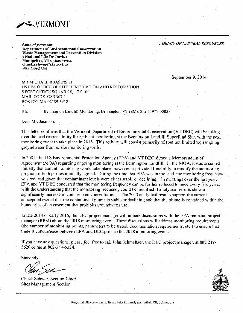
bull Transfer of ambient monitoring responsibility from the US EPA to VT DEC is documented in a letter dated September 9 2014 from Mr Chuck Schwer Section Chief of the Sites Management Section with the VT DEC to Mr Michael Jasinski Section Chief of MEVTCTNHRI Superfund Section with the US EPA (See Appendix G for copy of this letter)
2
Remedy Implementation Activities
No remedy implementation activities other than O amp M took place during this FYR period
System OperationOperation and Maintenance Activities
Long-term monitoring of groundwater surface water and sediment has continued during the period covered by this review (Fall 2009 to Summer 2014) Operation and maintenance activities continue to be performed by the Town of Bennington on a regular and timely basis
III FIVE-YEAR REVIEW PROCESS
Administrative Components
The Town of Bennington who is the PRP for the Site and the VT DEC were notified of the initiation of the FYR on January 29 2014 This FYR was led by Almerinda Silva the EPA Remedial Project Manager and John Schmeltzer the VT DEC Project Manager assisted in the review
The review which began on January 29 2014consisted of the following components
bull Community Notification and Involvement bull Document Review bull Data Review bull Site Inspection and bull Five-Year Review Report Development and Review
Community Notification and Involvement
Activities to involve the community in this five-year review process were initiated with a discussion in January 2014 between the Remedial Project Manager and Community Involvement Coordinator for the Site Per Region 1 policy a region-wide press release announcing all upcoming five-year reviews in New England was sent to all regional newspapers including the Bennington Banner The press release was sent on February 13 2014 and is attached in Appendix B The results of the review and the report will be made available at the Site information repository located at
Bennington Town Hall 205 South Street Bennington VT 05201
and at
US Environmental Protection Agency 5 Post Office Square Suite 100 Boston MA 02109-3912 3 v
Document Review
This five-year review consisted of a review of relevant documents including monitoring data Applicable groundwater surface water and sediment cleanup standards as listed in the 1998 Record of Decision and the Grant of Environmental Restrictions and Right of Access which describes institutional controls (See Appendix H for detail) were also reviewed
Data Review
A summary evaluation of groundwater surface water and sediment sampling results is presented below A No Further Action final Record of Decision (ROD) was signed in October 1998 which summarized the basis for the No Further Action (NFA) According to the ROD the NTCRA (ie landfill cap interceptor trench along with all of the other landfill cap components) resolved the exposure pathways with the exception of groundwater The ROD went on to say that the NTCRA institutional controls (ICs) will effectively prevent use of the contaminated groundwater at the Site Therefore the establishment of cleanup standards was not required for groundwater surface water or sediment Long-term monitoring is being performed to document that conditions documented in the Remedial InvestigationFeasibility Study (RIFS) and used as the basis for the NFA do not change Site-Specific Target Cleanup Goals (TCGs) were established for the long-term monitoring as a basis for evaluation of groundwater data The TCGs are the more stringent of the Maximum Contaminant Levels (MCLs) established by the Federal Safe Drinking Water Act or State of Vermont Groundwater Enforcement Standards (VTGWES) Contaminants of Concern (COCs) for the Site include metals (arsenic barium and manganese) and PCBs that have exceeded VTGWES and MCLs during long-term monitoring of Site groundwater Historically other metals that have been detected at the Site no longer exceed the TCGs Site groundwater monitoring wells surface water and sediment sampling locations are shown on Figure 2
Groundwater
According to the last FYR in 2009 groundwater data had indicated stable or decreasing trends in downgradient well contaminant levels Additionally at the time of the 2009 FYR the extent of downgradient metals and PCB impacts did not appear to be expanding beyond historic limits
Since the 2009 FYR groundwater surface water and sediment samples have been collected as part of the long-term monitoring required by the 1998 ROD In September 2009 groundwater samples were analyzed for volatile organic compounds (VOCs) semi-volatile organic compounds (SVOCs) metals and PCB homologs Surface water and sediment samples were analyzed for metals and PCB homologs In July 2010 groundwater surface water and sediment samples were analyzed for metals and PCB homologs In December 2013 groundwater surface water and sediment samples were also analyzed for metals and PCB homologs
A review of the results of September 2009 sampling indicates no VOCs or SVOCs were detected above the VTGWESMCL and most results were below laboratory detection limits Arsenic and manganese
4
concentrations were detected in exceedance of VTGWESMCL in several wells for both total and dissolved metals including well B-19 The highest concentration of arsenic (276 ugL) was detected at B-23 The highest concentration of manganese (3000 ugL) was detected at PZ-1 Groundwater samples were also analyzed for PCB homologs and samples from six of twenty-two wells contained PCBs at concentrations greater than 05 ugL The highest concentration (413 ugL) was detected at Bshy5-2
Twenty-two groundwater samples collected during July 2010 were only analyzed for metals and PCBs Arsenic and manganese concentrations were detected above the VTGWESMCL at most wells in both total and dissolved metals samples The highest arsenic concentration (921 ugL) was detected at B-2shy2 The highest manganese concentration (1953 ugL) was detected at B-19 Groundwater samples from five of twenty-two wells contained PCBs at concentrations greater than the target cleanup goal (TCG) of 05 ugL The highest concentration (209 J ugL) was detected at B-5-2
In 2013 groundwater samples were collected from 10 wells and analyzed for only total metals and PCB homologs Arsenic was not detected at concentrations exceeding the VTGWES however the detection limit was set at 20 ugL therefore concentrations were less than the detection limit but potentially higher than the VTGWES of 10 ppb Manganese concentrations were detected at concentrations above the VTGWES of 300 ppb (an MCL does not exist) in six of the ten wells sampled located upgradient from the landfill where manganese was 4-6 times higher than the VTGWES Total PCB concentrations did not exceed the 05ugL TCG
In summary concentrations of VOCs SVOCs metals and PCB homologs were within the historic range for samples collected as part of the RIFS and the 2006 long-term monitoring sample round with the exception of arsenic in the sample collected from well B-2-2 on July 26 2010 which was slightly higher than the historic range of concentrations The location and number of wells sampled as part of the long-term monitoring provide sufficient coverage to monitor the location and concentrations of the contaminated plume PCBs found were all located east of the edge of the landfill Based on the analytical data for the samples collected since the last FYR it appears that the contaminant plume has not expanded beyond its historic limits and it remains within the IC zone Concentrations of COCs detected in samples collected in 2009 2010 and 2013 are shown on Figure 3 in Appendix D and listed on Table 1 listed in Appendix C
Surface Water
Surface water samples have been collected as part of the long-term monitoring from wetlands and Hewitt Brook located hydraulically down gradient of the landfill According to the last FYR in 2009 surface water samples had only been collected in 1999 and 2000 up to that time Results of metals and PCBs were compared to RIFS data and concentrations were consistent As a result EPA determined surface water sampling was no longer necessary based on these unchanged conditions
Surface water sampling was reinstated as part of the long-term monitoring of the Site in 2009 Results of surface water samples collected in 2009 and 2010 indicated concentrations of metals were generally within the historic range detected in the RIFS with the exception of arsenic (591 ugL) and barium (2140 ugL) in the sample collected from SW-05 on September 18 2009 which were slightly higher than the historical range for samples collected as part of the Remedial Investigation In 2013 one surface water sample was collected at SW-02 which is immediately upstream from the Site boundary to
5
the east Concentrations of COCs in the2013 sample collected from SW-02 were lower than the 2010 sampling event and within the historic range of concentrations for surface water detected during the RI In general concentrations of COCs in surface water decrease with distance downstream of the landfill Concentrations of COCs detected in samples collected in 2009 2010 and 2013 are shown on Figure 4 in Appendix D and listed on Table 2 in Appendix C
Sediment
Sediment samples have been collected as part of long term monitoring from wetlands and Hewitt Brook located hydraulically down gradient of the landfill At the time of the last FYR in 2009 sediment samples had only been collected in 1999 In general the concentrations of PCBs were comparable to RIFS data Arsenic barium and iron were detected at higher concentrations however EPA concluded the concentrations did not pose an increased risk to human health or the environment As a result sediment sampling was discontinued
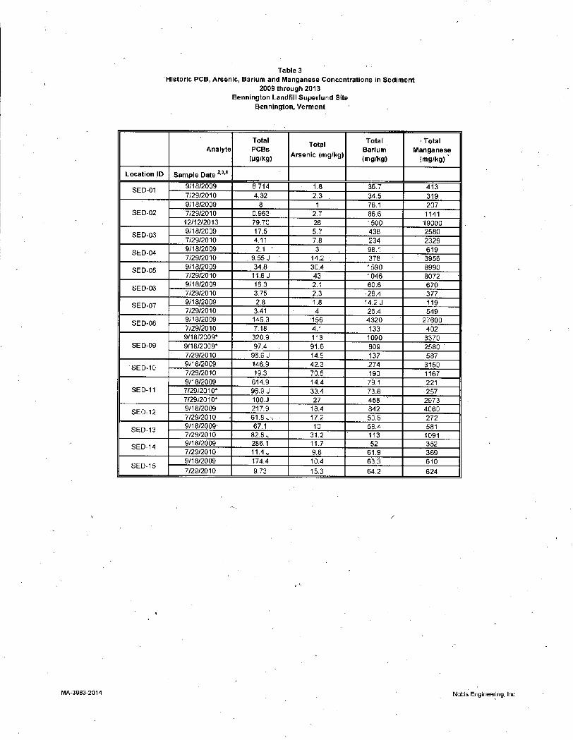
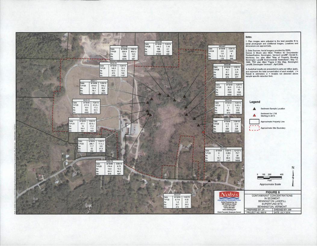
Sediment sampling was reinstated as part of the long-term monitoring of the Site in 2009 Numerous metals were detected in the sediment samples collected in September 2009 July 2010 and December 2013 Currently there are no standards for metals in sediments at the Site however these results are comparable to historical RIFS data and October 1999 long-term monitoring data The maximum concentrations of arsenic (156 mgkg) barium (4320 mgkg) and manganese (27600 ugL) were detected in thesample from SED-08 on September 18 2009 Concentrations of total PCB homologs were less than the NTCRA cleanup criteria of 1000 ugkg in long-term monitoring sediment samples collected in 2009 2010 and 2013 In general concentrations of COCs in sediment decrease with distance downstream of the landfill Concentrations of COCs detected in samples collected in 2009 2010 and 2013 are shown on Figure 5 and listed on Table 3
Site Inspection
The inspection of the Bennington Landfill was conducted on June 6 2014 In attendance were Almerinda Silva EPA Remedial Project Manager Michael Jasinski EPA MEVTCT amp NHRI Section Chief and Greg Michele Nobis Engineering Inc consultant to EPA Also in attendance were John Schmeltzer and James Surwilo representing VT DEC The purpose of the inspection was to assess the protectiveness of the remedy The inspection team walked the surface of the landfill and observed the condition of the landfill cap storm water drainage structures and gas vents Due to a significant reduction in the flow from the former landfill underdrain pipe the leachate collection treatment system (LCTS) installed to treat the landfill leachate was deactivated in 2008 and has not been used since that time Therefore the LCTS was not inspected A checklist was prepared during the inspection and photographs were taken to document the condition of the landfill all of which are presented in Appendix F
The landfill appeared to be in good condition on the date of the inspection The vegetated landfill surface was in good condition with no evidence of significant settlement erosion or damage Landfill gas vents and storm water drainage structures were observed to be in good working condition Several minor issues were identified during the inspection including
6
bull Several shallow holes less than 12 inches deep were observed on the eastern side of the landfill that may be animal burrows
bull Minor vegetation was observed growing in storm water drainage structures including slope benches and perimeter ditches
bull Woody vegetation was observed growing adjacent to the toe of the landfill cap and drainage structures in several locations
The Town should continue monitoring for and remove any burrowing animals found on the landfill Sediments and vegetation should be removed from drainage structures if the flow of storm water is impeded Woody vegetation growing adjacent to the landfill cap should be removed periodically These items can be addressed as part of the routine operation and maintenance and do not affect the protectiveness of the landfill cap system Changes in the use of the Site were not observed that would be inconsistent with the ICs place on the Site property
Interviews
During the FYR process interviews were conducted by Almerinda Silva EPA Remedial Project Manager with parties impacted by the Site These parties included Stuart Hurd Manager for the Town of Bennington and PRP representative John Schmeltzer VT DEC Project Manager Steve Bruso resident and Site gate keeper Dale Baker Manager for Cassella Waste Management and Brenda Rowland resident The purpose of the interviews was to document any perceived problems or successes with the remedy that has been implemented to date Interviews were conducted during the month of July 2014 The general consensus was that the Site was functioning as intended and being maintained properly No one had questions or concerns The record of interviews is included in Appendix E
IV TECHNICAL ASSESSMENT
QUESTION A Is the remedy functioning as intended by the decision documents
Yes
RemedialAction Performance
The long-term monitoring data and oversight inspections confirm that the NTCRA is functioning as intended and that the No Further Action ROD monitoring program is being implemented The information sources include review of the available documents review of post NTCRA monitoring data the interviews and the Site inspection The landfill cap and the leachate collection treatment system (LCTS) have achieved the remedial objectives to minimize the migration of contaminants and prevent direct contact with or ingestion of contaminants
7
Evidence to indicate that the remedy is performing as intended includes the following
bull The remedial objectives of the cap have been achieved by preventing direct exposure to waste and contaminated soils All waste materials consolidated under the cap as part of the NTCRA were placed at least 30 feet above the groundwater table to ensure there would be no further impact to area groundwater
bull There is no indication that the cap is leaking therefore the objective of reducing or eliminating the generation of landfill leachate has been met The cap is maintained and inspected by the Town of Bennington The Town is responsible for repair work at the landfill
bull At the time of this FYR the landfill cap and upgradient groundwater isolation system appear to be functioning as designed and in good overall condition The surface of the landfill remains stable and shows no signs of erosion or cracks The benches in the landfill surface are also functioning as designed and in good overall condition Perimeter ditches remain in good overall condition and operating as designed The outlet pipes and riprap outlet of the drainage layer at the perimeter of the cover system remains in good overall condition The upgradient groundwater isolation system continues to function as designed and requires minimal maintenance
bull Construction of the landfill cap and leachate collection system were designed to eliminate the discharge of contaminants to surface water receptors With continued maintenance of the landfill cap and decommissioning of the leachate collection system in 2008 future compliance regarding surface water and sediments can be expected without additional remedial action
System OperationsOampM
bull The operation and maintenance of the cap and the decommissioning of the leachate collection system has been and continues to be effective Issues identified during semi to annual inspections are regularly addressed or continue to be monitored The current sampling and analytical methods for groundwater surface water and sediment are adequate to evaluate the performance of the remedy The location and number of wells sampled give sufficient coverage to monitor the location and concentrations of the contaminated plume within the IC zone
Opportunitiesfor Optimization
bull EPA in consultation with VT DEC has reduced the number of wells to be sampled and the monitoring frequency to every five years unless a reason arises in the future that necessitates an increase in monitoring
Early Indicators of Potential Issues
bull There have not been any indicators of potential issues (such as IC non-compliance) since the last FYR
Implementation of Institutional Controls and Other Measures
bull A restrictive covenant has been placed on the property to prevent the use of contaminated groundwater and disturbance to the cap and its appurtenances The impacted groundwater has been reclassified as non-potable to further prevent future use No activities were observed that would have violated the institutional controls ICs ensure that the risk of exposure is low by preventing use of groundwater and any land activities that could threaten the effectiveness of the landfill cap and remedy as well as to protect against risk to human health and the environment
QUESTION B Are the exposure assumptions toxicity data cleanup levels and remedial action objectives (RAOs) used at the time of the remedy section still valid
No Although there have been changes in exposure assumptions and risk assessment methods since the risk assessments were conducted to support the 1998 ROD the changes do not affect the remedy protectiveness as discussed below
Changes in Standards and TBCs
As discussed in the 2009 FYR the MCL for arsenic was updated from 50 ppb to 10 ppb in 2002 There have been no other changes to the COCs identified in the February 1998 Risk Assessment As no groundwater cleanup levels were identified for the Site in the No Further Action ROD and institutional controls prevent the use of groundwater the new arsenic MCL does not affect the protectiveness of the remedy
Changes in ExposurePathways
For groundwater the exposure assumptions used to develop the ROD focused on the groundwater ingestion pathway potential dermal contact with groundwater used as a household water source and inhalation of volatiles during household water use were not evaluated However these pathways presently are not a concern because institutional controls prevent residential development installation of groundwater wells and use of groundwater for any purpose In addition based on the analytical data collected for the samples collected since the 2009 five-year review the contaminant plume has not expanded beyond its historical limits and COCs identified in the 1998 Risk Assessment do not appear to be migrating off site
The vapor intrusion pathway was not evaluated in the 1998 ROD The current and future land use of the landfill itself is considered non-residential because of the institutional controls which prevent
9
constructing residences on the landfill The areas surrounding the landfill are considered residential however the residences are not currently located in close proximity to the predicted location of the plume The transfer station adjacent to the landfill is not an enclosed structure and therefore any potential future vapor intrusion pathway for this building is not complete
Changes in Toxicity
There have been no changes to the toxicity values of the COCs identified in the February 1998 Risk Assessment since the 2009 FYR
Changes in Risk Assessment Methods
In 2014 EPA finalized a Directive to update standard default exposure factors and frequently asked questions associated with these updates httpwwwepagovoswerriskassessmentsuperfund hh exposurehtm (items 22 and 23 of this web link) Some of these exposure factors differ from those used in the risk assessments for the 1998 ROD These changes in general would result in a slight decrease of the risk estimates for most chemicals Also note that changes in exposure factors for the groundwater exposure pathway that have occurred since the 1998 ROD do not affect the remedy because of its reliance on institutional controls incorporated during the NTCRA which prevent residential development installation of groundwater wells and use of groundwater for any purpose
Expected Progress Towards Meeting RAOs
The remedy is progressing as expected Data indicate that the landfill cap and isolation trench are effective at preventing infiltration of water through the solid waste mass Decommissioning of the LCTS in 2008 is another measure that leachate has been significantly reduced thus is not negatively impacting the shallow unit of groundwater downgradient of the landfill Cleanup goals for arsenic iron manganese and PCBs are not fully met Flowever the contaminant plume has not expanded its extent either horizontally or vertically indicating that the remedy is effective at preventing the spread of site-related contamination There are no ARARs established at this Site and this FYR found no appreciable changes from the last two FYRs In addition ICs ensure that risk of exposure is low by preventing use of groundwater and any land activities that could threaten the effectiveness of the landfill cap and remedy as well as protect against risk to human health or the environment
QUESTION C Flas any other information come to light that could call into question the protectiveness of the remedy
No
10
Technical Assessment Summary
According to the data reviewed the Site inspection and the interviews the remedy is functioning as intended by the NTCRA Action Memorandum and ROD There have been no changes in the physical conditions of the Site that would affect the protectiveness of the remedy There have been no significant changes to the overall exposure assumptions used in evaluating human health and ecological risk Because the Site is a no further action there are no ARARs set in the 1998 ROD at this Site There is no other information that calls into question the protectiveness of the remedy
V ISSUESRECOMMENDATIONS AND FOLLOW-UP ACTIONS
There are no issues which affect the protectiveness of the remedy For continued protection and effectiveness of remedy implementation regular OampM should be continued by the Town of Bennington with oversight by VT DEC and EPA
While there are no protectiveness issues at this time it is possible that conditions not addressed by continued and timely OampM could potentially affect protectiveness in the future Future remedy protectiveness would only be affected if the OampM is not consistent at or above the level conducted at present
VI PROTECTIVENESS STATEMENTS
Protectiveness Statement(s)
Operable Unit Protectiveness Determination Addendum Due Date Operable Unit OU1 ampOU2 Site Wide Protectiveness Statement (if applicable)
Click here to enter a date
Protectiveness Statement Contamination at the Site has been addressed through excavation and on-site disposal of contaminated soil capping of contaminated soil on-site a leachate and groundwater collection system on-site treatment of contaminated groundwater and leachate gas collection vents and institutional controls thus there is no exposure of Site related waste to humans or the environment at levels that would represent a health concern Operation and maintenance activities and regular oversight inspections ensure that the remedy remains effective and the Site is protective of human health and the environment
VII NEXT REVIEW
The next five-year review report for the Bennington Landfill Superfund Site is required five years from the signature date of this review in 2019
11
APPENDIX A
Existing Site Information
APPENDIX A -EXISTING SITE INFORMATION
A SITE CHRONOLOGY
Table 1 Chronology of Site Events
Date Event
prior to 1969 Site run as a sand and gravel operation
1969-1985 Site leased by the Town of Bennington as a municipal solid waste and industrial dump
1969-1975 Portion of the site used as a liquid waste lagoon
1987 Landfill closed
March 31 1989 NPL listing
1990 State solid waste closure performed by the Town of Bennington
1991 Remedial Investigation (RI) begun
December 23 1994 Action Memorandum to initiate Non-Time Critical Removal Action (NTCRA) signed
November 26 1996 Administrative Order on Consent (AOC) for NTRCA design signed
December 1996 NTCRA design phase begins
August 18 1997 Consent Decree for construction and maintenance of NTCRA signed
September 1997 NTCRA construction begins
December 23 1997 RI completed
July 1 1998 Restrictive covenant and groundwater reclassification for landfill and area of groundwater impact implemented
September 29 1998 Record of Decision signed
1998 Maintenance and monitoring
June 30 1999 NTCRA construction completed PCOR signed
September 21 2004 First Five-Year Review Report signed
2004-2009 Ongoing Site monitoring maintenance and inspections
September 11 2009 Second Five-Year Review signed
14
August 2014 Long-Term Monitoring Transferred from EPA to VT DEC
September 2014 Third Eive-Year Review signed
B BACKGROUND
Physical Characteristics
The Site consists of a 15-acre municipal solid waste landfill and associated drainage pond situated in an 85-acre parcel owned by the Town of Bennington Vermont Prior to the landfill the location of the Site was a sand and gravel pit The areas to the north and east of the Site are former borrow pits The area directly east of the Site is wetlandwoodland that is within the groundwater institutional control area and is unlikely to be developed in the future The other areas surrounding the Site are residential The Site is bordered by wetlands serving as headwaters for Hewitt Brook to the east of the Site residential areas are to the south and US Route 7 to the west The 2006 US Census Bureau population estimate for the Town of Bennington is 36382
Hydrology
There are two groundwater systems at the Site The shallow system is comprised of a surficial sand and gravel unit that ranges in thickness from 7 to 29 feet The saturated thickness of the sand and gravel unit increases with the thickness of the unit The surficial sand and gravel unit is underlain by a dense glacial till This unit was consistently dry during drilling and has been characterized as a confining layer The till layer thickness ranges from 0 feet west of the landfill to 530 feet east of the landfill
The bedrock and a deep sand and gravel unit represent the second water bearing formation at the Site This unit is separated from the surficial sand and gravel unit by the till layer Bedrock is exposed in several locations upgradient of the landfill limiting the horizontal extent of the surficial sand and gravel unit Groundwater flow in the surficial sand and gravel unit is predominantly west to east with the headwaters of Hewitt Brook serving as a discharge zone for the groundwater This is confirmed by the pattern of groundwater contamination
Land and Resource Use
There were no zoning or other land use restrictions in place at the start of the remedial investigation and feasibility study (RIFS) that would have precluded future residential use of the Site The restrictive covenant implemented by the Town of Bennington and State of Vermont as part of the NTCRA prohibits residential development and helps prevent exposure to contaminated soil and groundwater Landfill use decisions in Bennington County are made by the Bennington County Regional Planning
15
Commission in accordance with their Regional Plan (most recent is May 17 2007)
A solid waste transfer station and recycling center are currently located adjacent to the landfill This transfer station accepts mixed solid waste and recyclables It is operated by Casella Waste Management
To compensate for Natural Resource Damages at the Site the US Fish and Wildlife Service and the Town of Bennington conducted a wetland restoration project approximately 3 miles southeast of the Site on Burgess Road An antiquated water collection system of concrete cisterns and underground pipes was removed to restore natural hydrologic conditions The restoration project was completed in 1998 with monitoring through 2001 The project restored 28 acres of wetland and protected 14 acres of wetland and upland in perpetuity via a conservation covenant as required by the 1997 Consent Decree
In addition as compensation for Natural Resource Damages at two other Superfund Site (the Burgess Brothers Landfill and the Tansitor Electronics Site) the US Fish and Wildlife Service has restored 2 acres of wetland and 7 acres of grassland immediately adjacent to the Bennington Landfill Superfund Site This effort was completed in partnership with the Town of Bennington and the USDA Natural Resource Conservation Service
History of Contamination
The landfill began operations in 1969 and received commercial residential and industrial solid and liquid wastes The Town of Bennington leased the property for use as a landfill until 1985 when the Town purchased the property In April 1987 the landfill was closed and the Town established a transfer station adjacent to the landfill
Throughout the entire period of operation (1969 - 1987) residential industrial and commercial waste was disposed in the landfill One portion of the landfill was used for disposal of liquid wastes from 1969 -1975 This area known as the lagoon was covered with debris and is within the limits of the current solid waste mass A drainage system was constructed within the landfill in 1976 to lower the groundwater level in the waste The outlet for this drainage system was a pipe the discharge from which was responsible for the creation of the drainage pond
The Town of Bennington performed a solid waste closure of the landfill in 1990 in accordance with the Vermont Solid Waste Program Collection of the underdrain discharge was not included in the solid waste closure
The surficial sand and gravel aquifer was impacted by the landfill PCBs VOCs (including vinyl chloride chloroethane 11-dichloroethene 12-dichloroethene 111-trichloroehtane trichoroethene methylene chloride and benzene) and several metals (arsenic barium and manganese) were detected at elevated levels Elevated levels of PCBs were also found in the soil and sediment of a small area of standing water near the outlet to the discharge from the drainage pipe
The contamination of the surficial sand and gravel aquifer extended from under the landfill to the area to the east where groundwater recharges the wetland serving as headwaters for Hewitt Brook Elevated levels of contaminants were detected in wells abutting the landfill and dropped significantly within several hundred feet of the landfill There was an increase in arsenic with distance from the landfill that was likely a results of the mobilization of arsenic from natural soil materials due to a reducing environment created by the presence of landfill leachate Very low levels of VOCs were detected in the
16
bedrock aquifer adjacent to the landfill High levels of PCBs were found in the soil and sediment adjacent to the discharges from the underdrain discharge pipe Some of the PCBs migrated into the sediments of the wetland and of Hewitt Brook
Initial Response
In December 1994 EPA signed an Action Memorandum to initiate a non-time-critical removal action (NTCRA) at the Site to address the source of contamination The NTCRA was designed to control the source of contamination to groundwater surface water and sediment The major components of the NTCRA are
bull Construction of a multi-barrier landfill cap over the entire waste mass bull Construction of an upgragdient interceptor trench to divert groundwater upgradient of the
landfill around the waste bull Construction of a leachate collection and treatment system to collect and treat discharge
from the underdrain discharge pipe and bull Excavation and consolidation of sediments and soils with PCB concentrations above 1
milligram per kilogram (mgkg)
The NTCRA also included ICs to prevent future use of the Site EPA entered into an Administrative Order with the potentially responsible parties (PRPs) for the design of the NTCRA in 1996 EPA and the PRPs entered into a CD in August 1997 The CD required the PRPs to perform construction activities implement ICs and perform long-term post-removal Site control (PRSC) All construction activities and ICs included in the NTCRA were completed in June 1999
Basis for Taking Action
The initial cleanup action was taken to address the PCB contamination in sediment adjacent to the landfill and to comply with federal and state landfill closure requirements The Human Health and Ecological Risk Assessment (HHERA) concluded that there was not an unacceptable risk to human health or the environment after completion of the NTCRA
C REMEDIAL ACTIONS
Remedy Selection
A ROD selecting no further action was signed in September 1998 This ROD records the final remedy decision for the Site Based on the RIFS HHERA and monitoring results upon the completions of the NTCRA the ROD determined that no further remedial action was required at the Site to ensure protectiveness of human health and the environment The ROD did include a long-term monitoring requirement to confirm that conditions upon which the remedy decision was based do not change EPA is responsible for monitoring activities during the first 10 years (December 1999 shyDecember 2009) of the Sites post construction life and the State of Vermont is responsible for the
17
remainder
Remedy Implementation
The long-term monitoring required by the ROD is being implemented by EPA The NTCRA construction activities and ICs were completed in June 1999 The cleanup actions implemented by the NTCRA are operated and maintained by the Town of Bennington in accordance with the Action Memorandum and the 1997 CD with EPA providing oversight
Institutional Controls
ICs are non-engineered instruments such as administrative andor legal controls that help minimize the potential for exposure to contamination and protect the integrity of the remedy Compliance with ICs is required to assure long-term protectiveness for any area that do not allow for unlimited use or unrestricted exposure (UUUE) ICs are required at the Site to ensure the protectiveness of the remedy and are selected in both the NTCRA Action Memorandum and ROD All non-UUUE areas are addressed effectively by ICs as determined by IC evaluation activities discussed below The ICs in use at this Site are effective and no further ICs or changes to the current ICs are recommended at this time
ICs in Site Documents
The 1993 Action Memorandum for the NTCRA included ICs and the 1997 CD and NTCRA Statement of Work (SOW) detailed IC requirements and outlined the objectives
bull restrict groundwater use bull limit exposure to landfill material bull bull protect remedy components and bull maintain effectiveness and integrity of response actions
The ROD states that the ICs implemented as part of the NTCRA adequately address the exposure potential from future use of groundwater
IC Implementation
The Town of Bennington as PRP and site owner recorded a restrictive covenant on the Site properties on July 1 1998 (Town of Bennington Landfill Records 0-343 p81) The Town is the grantor and the State the grantee on this covenant The covenant includes a 35 acre capped landfill parcel and a 46-acre groundwater restriction parcel Surveys of both parcels are included in the recorded covenant The covenant includes perpetual right of access listings of restricted activities emergency provisions enforcement stipulations and termination provisions The covenant runs with the land and is incorporated into all deeds mortgages leases and transfers In brief the restrictions included in the restrictive covenant are
bull no use that disturbs the integrity of the cap LCTS gas vents or other response action or monitoring structures
bull ho use of groundwater for any purpose
18
bull no installation of groundwater wells for purposes other than site-related monitoring and bull no residential development
In addition to the restrictive covenant the State of Vermont reclassified the groundwater at the Site as Class IV (non-potable) This IC provides a layered approach to the potential for groundwater exposure furtherensuring that the groundwater is not used for any purpose
Operation and Maintenance
The Town of Bennington is conducting long-term monitoring and maintenance activities associated with the PRSC Such activities focus on the condition of the multilayer landfill cap (eg vegetative cover erosion) the operation of the LTSC now decommissioned and underdrain system and groundwater monitoring The primary activities associated with maintenance and long-term monitoring include
bull regular monitoring and maintenance of the LCTS bull regular inspection of the landfill cap and
bull regular inspection of the landfill cap collection system
EPA conducts annual inspections of the Site as part of EPAs oversight of the Town of Bennington Inspections are typically conducted each spring Oversight of ambient monitoring was transferred from EPA to the State of VT on September 9 2014 The future monitoring will also include inspection to ensure that the prohibited activities associated with the land use restrictions do not occur EPA will remain responsible for conducting future Five-Year Reviews of this Site
19
APPENDIX B
PRESS RELEASE ANNOUNCING THE FIVE-YEAR REVIEW
I
^STy
j z EPA New England News Releaseraquo w1 o A Jy Protecting Human Health and the Environment
PRO
News Release US EnvironmentalProtection Agency New England Regional Office February 13 2014
Contact Emily Zimmerman 617-918-1037
EPA Will Review 27 Superfund Site Clean Ups This Year -
Boston Mass - (February 13 2014) - EPA will review site clean ups and remedies at 27 Superfund Sites across New England this year by doing routine Five-Year Reviews at each site
EPA conducts evaluations every five years on previously-completed clean up and remediation work performed at Superfund sites and Federal Facilities listed on the National Priorities List (aka Superfund sites) to determine whether the implemented remedies at the sites continue to be protective of human health and the environment Further five year review evaluations identify any deficiencies to the previous work and if called for recommend action(s) necessary to address them
In addition to a careful evaluation of technical work at the sites during the Five Year Review process EPA also provides the public with an opportunity to evaluate preliminary findings and to provide input on potential follow up activity that may be required following the review process
The Superfund Sites at which EPA is performing Five Year Reviews over the following several months include the following sites Please note the Web link provided after each site provides detailed information on site status and past assessment and cleanup activity
Notes Indicates a duplicate groundwater sample 1 All sample results in micrograms per liter (pgL) equivalent to parts per billion 2 VTGWES = Vermont Groundwater Enforcement Standard (State of Vermont Agency of Natural
Resources (VTANR) Revised May 2005) MCL = Maximum Contaminant Level (USEPA) 3 Interim VTGWES (VTANR 362009) 4 NS = No Standard established PCBs = polychlorinatedbiphenyls B = Value is between
instrument detection limit and Contract Required Detection Limit (CRDL) E = Estimated due to presence of interference J = Estimated value U = Not detected above specified instrument detection limit (prior to 2004) not detected above the Contract Required Quantification Limit (2004 Data) or below detection limit (2009 and 2010 data)
5 Bold values exceed VT-GWES andor MCL 6 Data dated 2009 excerpted from Draft Fall 2009 Groundwater Monitoring Datas Summary Report
Bennington LandfillSuperfund Site Bennington Vermont Nobis Engineering Inc June 2010 7 Data dated 2010 excerpted from July 2010 GroundwaterMonitoring Datas Summary
Bennington LandfillSuperfund Site Bennington Vermont Nobis Engineering Inc August 2011 8 Data dated 2013 collected by EPA 9 Yellow highlight signifies wells that were sampled in December 2013
MA-3983-2014 Nobis Engineering Inc
1
Table 2 Historic PCB Arsenic Bariumand Manganese Concentrations in Surface Water
2009 through 2013 Bennington LandfillSuperfund Site
Bennington Vermont
Total PCBs1 Total Arsenic Total Barium Total ManganeseAnalyte (ugL) (MS)-) (M9L) (M9-)
1 PCBs = polychlorinated biphenyls J = Estimated value U = Not detected above detection limit
2 Data dated 2009 excerpted from Draft Fall 2009 Groundwater MonitoringDatas Summary Report Bennington LandfillSuperfund Site Bennington Vermont Nobis Engineering Inc June 2010
3 Data dated 2010 excerpted from July 2010 GroundwaterMonitoring Datas Summary Bennington LandfillSuperfund Site Bennington Vermont Nobis Engineering Inc August 2011
4 Data dated 2013 collected by EPA
MA-3983-2014 Nobis Engineering Inc
Table 3 Historic PCB Arsenic Barium and Manganese Concentrations in Sediment
2009 through 2013 Bennington Landfill Superfund Site
Engineering a Susiainaote Future Nobis Engineering Inc 585 Middlesex Street
Lowell MA 01851 T(978) 683-0891
wwwnobiseng com Cbent-Focused Employee-Owned
F I G U R E 1
LOCUS MAP BENNINGTON LANDFILL
SUPERFUND SITE BENNINGTON VERMONT
PREPARED BY JH CHECKED BY GM PROJECT NO 80019 DATE JULY 2014
Notes
1 Plan images were adjusted to the best possible fit to aerial photograph and additional images Locations and dimensions are approximate
|Ba13(RZ)1 2 Data Sources Aerial imagery provided by ESRI
B-10(PZ) $bull Dames amp Moore plan tilled Petition for Groundwater Reclassification Bennington Vermont Landfill Gerald E Morrissey Inc plan titled Map of Property Showing Bennington Landfil Environmental Restrictions May 13 1998 TRC plan titled Figure 2 Site Map Bennington Landfill Bennington Vermont April 2006
Legend
^SWSEDg]
smsedI ZO Monitoring Well
Monitoring Well for LTM Starting in 2013
[SVySEDl13][S^EDSllMKSWSED^15]
[SWSEB05l
Surface Water Sediment Sample Location
Surface Water Sediment for LTM Starting in 2013
Approximate Property Line
| Approximate Site Boundary
|B83(AB)1
[sMsebioh Feet
Approximate Scale
FIGURE 2 SITE MAP
BENNINGTON LANDFILL SUPERFUND SITE
BENNINGTON VERMONT
PROJECT NO 80019 DATE JULY 2014
72710 00047 102 162 J 1963
121113 0002 J 20 U 130 1200
91509 000003 29 J
664 J 372
72710 00027 39 J
521 J 11SJ
Date T-PCB As Ba Mn
121113 00007 J
20 U
Date T-PCB As Ba Mn
9172009 0005 10 U
72910 00018 J
27 J
Notes
1 Plan images were adjusted to the best possible fit to aerial photograph and additional images Locations and dimensions are approximate
B-10(PZ) 2 Data Sources Aerial imagery provided by ESRI Dames amp Moore plan tilled Petition for Groundwater Reclassification Bennington Vermont Landfill Gerald E
91709 72810 Morrissey Inc plan titled Map of Property Showing 00418 Bennington Landfil Environmental Restrictions May 13
Date T-PCB
91509 72710 00815 Date 91509 72710
1998 TRC plan titled Figure 2 Site Map Bennington Landfill Bennington Vermont April2006
I As Ba
|Mn
91509 129 10U
27 J 487 64 J
7272010 0580 39 J
T-PCB As Ba Mn
0403 276 1160 504
0223 295 956 450 91609
136 228 651 716
72810 0620 J 226 631 640
121013
3 Analyticalresults are presented in parts per billion (ppb) and represent the total concentration of each analyte Bold values indicate an exceedance of Vermont Groundwater Enforcement Standard (VTGWES) or MCL J = Result is estimated U = Analyte not detected above sample specific detection limit T-PCB = Total Polychlorinated Biphenyl Homologues
91509 72710 121113 FIGURE 3 00002 0000121 0013 J CONTAMINANT CONCENTRATIONS IN 10 U
931 J 270
26 J 363 J 38 J
20 U 32
20 U
91509 00006 10U
72710 00069
3 J
121113 0002 J 20 U
GROUNDWATER BENNINGTON LANDFILL
SUPERFUND SITE 105 J 113
109 J 143
120 640
BENNINGTON VERMONT PREPARED BY JH CHECKED BY GM
PROJECT NO 80019 DATE JULY 2014
91809 NA NA NA NA
91809 01198 J
74 525 716
72910 00426 J
29 540
184
91809 010683 J
205 511 299
72910 00381 J
31 552 402
Date T-PCB As Ba Mn
91809 053176 J
54 435
1040
72910 00781 J
23 525
166
91809 047184 J
107 729 2080
72910 00474 J
27 551 515
Date T-PCB As Ba Mn
91809 064552 J
101 757 2300
SW-09 91809
NA NA NA NA
72910 00137 J 093 J 271 279
SW-08 91809
NA NA NA NA
72910 SW-07 91809
001208 J 119 611 5080
72910 00118
38 440
72910 NA NA NA NA
SW-06 91809 72910
NA 095 J
305 49
SW-05 91809
003775 J 72910
2140 14200
SW-04 91809
NA 72910 00198 J 067 J
744 749
SW-03 91809 72910
00108 J 041 J 548
SW-02 91809 72910 121213
NA 00072 J 00003 022 J 049 J 20 U
401 459 370 402 127 89
72910 00922 J
24 573
785
SW-01 91809 72910
NA 022 J
383 147 J
1 Plan images were adjusted to the best possible fit to aerial photograph and additional images Locations and dimensions are approximate
2 Data Sources Aerial imagery provided by ESRI Dames amp Moore plan titled Petition for Groundwater Reclassification Bennington Vermont Landfill Gerald E Morrissey Inc plan titled Map of Property Showing Bennington Landfil Environmental Restrictions May 13 1998 TRC plan titled Figure 2 Site Map Bennington Landfill Bennington Vermont April 2006
3 Analytical results are presented in parts per billion (ppb) and represent the total concentration of each analyte J = Result is estimated U = Analyte not detected above sample specific detection limit
585 Middlesex Street Lowell MA 01851 T(978) 683-0891
wwwnobisengcom Client-Focused Employee-Owned
Notes
1 Plan images were adjusted to the best possible fit to aerial photograph and additional images Locations and dimensions are approximate
2 Data Sources Aerial imagery provided by ESRI Dames amp Moore plan titled Petition for Groundwater Reclassification Bennington Vermont Landfill Gerald E Morrissey Inc plan titled Map of Property Showing Bennington Landfil Environmental Restrictions May 13 1998 TRC plan titled Figure 2 Site Map Bennington Landfill Bennington Vermont April 2006
3 Analytical results are presented in parts per billion (ppb) and represent the total concentration of each analyte J = Result is estimated U = Analyte not detected above sample specific detection limit
Legend
Sediment Sample Location
Sediment for LTM Starting in 2013
j Approximate Property Line
Approximate Site Boundary
0 100 200
Feet
Approximate Scale
FIGURE 5 CONTAMINANT CONCENTRATIONS
IN SEDIMENT BENNINGTON LANDFILL
SUPERFUND SITE BENNINGTON VERMONT
PREPARED BY JH CHECKED BY GM
PROJECT NO 80019 DATE JULY 2014
APPENDIX E
RECORD OF INTERVIEWS
INTERVIEW DOCUMENTATION FORM ( The following is a list of individuals interviewed for this five-year review See the attached
Record of Interviews for a detailed summary of the interviews
1 SETTLEMENT (LOW SPOTS) Yes bull No 0 Location (indicate on site map) Areal Extent v Depth
2 CRACKS Yes bull No 0 Location (indicate on site map) Length Width Depth
3 EROSION Yes bull No 0 Location (indicateon site map) Areal Extent Depth
[a sS i iA^-ov 54 HOLES Yes 0 No bull c-v- S~r sr t^-e poundr~Location (indicate on site map)
Areal Extent Depth (e rs Z-CfSuspected Cause (rodent or other)
5 VEGETATIVE COVER Yes f2]_ No bull Grass Condition TreesShrubs Yes bull No K Location (indicate on site map) Size
6 ARMORED COVER Yes bull No Material Type Condition
7 BULGES Yes bull No Location (indicate on site map) Areal Extent Height Suspected Cause (gas pressure or other)
1shy
1
ITEM
8 WET AREAS Ponding Location (indicate on site map) Areal Extent
Seeps Location (indicate on site map) Areal Extent Estimated Flow Rate
Soft Subgrade Location (indicate on site map) Areal Extent
9 SLOPE INSTABILITY Slides Location (indicate on site map) Areal Extent Probable Slide Interface Suspected Cause Exposed Cover Components
BENCHES
1 FLOW BYPASS BENCHES Location (indicate on site map) Description of Problem
2 BENCH BREACHED Location (indicate on site map) Description of Problem
LETDOWN CHANNELS
1 SETTLEMENT Location (indicate on site map) Areal Extent - Depth
2 MATERIAL DEGRADATION Material Type Location (indicate on site map) Areal Extent Degree of Degradation
3 EROSION Location (indicate on site map) Areal Extent Depth
REMARKS
Yes bull No
Yes bull No 0
Yes bullbull No 13
Yes bull No 0]
Yes bull No O
Yes bull No EL
Yes bull No i
Yes bull No JE
Yes bull No
2
ITEM REMARKS
4 UNDERCUTTING Yes bull No EL Location (indicate on site map) Areal Extent Depth
5 OBSTRUCTIONS Yes bull No 0 Type Location (indicate on site map) Areal Extent Size
6 VEGETATIVE GROWTH Yes El No bull Type Location (indicate on site map) Areal Extent
COVER PENETRATIONS
1 GAS VENTS Active (^Passive Located Yes 0 No bull Functioning Yes 0 No bull Condition
2 GAS MONITORING PROBES Yes bull No 0 Located Yes bull No bull Functioning Yes bull No bull Condition lt
MONITORING WELLS Yes B No bull Located Yes bull No S Functioning Yes bull No bull Condition l^gL va-qT Ueuro-l(
COVER DRAINAGE LAYER
1 OUTLET PIPES Yes 0L No bull Functioning Yesreg No bull Condition sgt lt=-bull
2 OUTLET ROCK Yes 0L No D Functioning Yes 0 No bull Condition
RETAINING WALLS (End of UGIT)
1 DEFORMATIONS Yes bull No Location (indicate on site map) Horizontal Displacement Vertical Displacement Rotational Displacement
2 DEGRADATION Yes bull No amp Location (indicate on site map) Description of Damage
A_ilt3YJTU Sgt ^ eraquo ^cX- ugt4-e_cA_r i~ gt p y VAOT cTo ^pc-cr-Ppt-sy CTe- gt T
3
ITEM REMARKS
GROUNDWATER SYSTEMS
1 LEACHATE COLLECTION AND tw ) bullgt- uj-CSi 3~T^shyTREATMENT SYSTEM Functioning Yes bull No
- Influent wet wellpumps Yes bull No bull Piping flow meters etc Yes bull No bull Particulate and Yes bull No bull carbon filters Effluent wet wellpumps Yes bull No bull
Routinely Monitored Yes bull No bull 2 UPGRADIENT GROUNDWATER
ISOLATION TRENCH Flowing Yes 0 No bull Estimated discharge
PERIMETER DITCHESOFF-SITE DISCHARGE
1 SILTATION Yes bull No Location (indicate on site map) Areal Extent Depth
2 VEGETATION GROWTH Yes No bull Location (indicate on site map) (-CKAcRci Areal Extent Type S
EROSION Yes O No aI Location (indicate on site map) Areal Extent Depth
j i S v c gt L Q G L Spound4 DISCHARGE STRUCTURE O C-ip( I O1-- ^ Functioning Yes IE No bull
Condition (Sroa cX
FENCING
1 FENCING DAMAGE Yes bull No Location (indicate on site map) Description of Damage
PERIMETER ROADS
1 ROADS DAMAGED Yes bull No Location (indicate on site map) Description of Damage
SITE ACCESS
1 ACCESS RESTRICTION Yes bull No
4
ITEM REMARKS
GENERAL
1 VANDALISM Location (indicate on site map) Description of Damage
2 CHANGED SITE CONDITION
Yes bull No
Yes bull No
J2L
[Zl
5
A
INTERVIEWS (conduct interviews if the following are present during inspection)
1 INTERVIEW WORKERS ON SITE l oT ^ ^ Problems Suggestions Attach Report
2 INTERVIEW SITE NEIGHBORS Af o T AV UltL Problems Suggestions Attach Report
3 INTERVIEW LOCAL OFFICIALS AJ T~ pre ^-sp-ampltrr~lt 0^ Problems Suggestions shyAttach Report
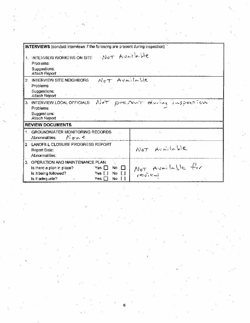
REVIEW DOCUMENTS
1 GROUNDWATER MONITORING RECORDS Abnormalities ^i copy vraquo eurobull
2 LANDFILL CLOSURE PROGRESS REPORT Report Date A)c t Av^ Abnormalities
3 OPERATION AND MAINTENANCE PLAN Is there a plan in place Yes bull No bull VioT i c- L Is it being followed Yes Q No O Is it adequate gt Yes bull No bull
6
Attachment 2I
Site Inspection Photographs June 6 2014
Bennington Landfill Superfund Site Site Inspection June 6 2014
Photo 2 Eastern perimeter ditch town transfer station to the left
Bennington Landfill Superfund Site Site Inspection June 6 2014
Photo 3 End of the Upgradient Groundwater Isolation Trench looking south
Photo 4 Southern side of landfill looking north
Bennington Landfill Superfund Site Site Inspection June 6 2014
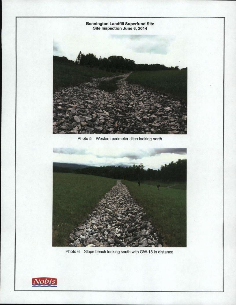
Photo 5 Western perimeter ditch looking north
Photo 6 Slope bench looking south with GW-13 in distance
Bennington Landfill Superfund Site Site Inspection June 6 2014
r
Photo 7 View from top of landfill looking east
Photo 8 View of gravel pit to the northwest of the landfill
Bennington Landfill Superfund Site Site InspectionJune 6 2014
Photo 9 Perimeter ditch at northwest corner of landfill from access road to gravel pit
Photo 10 View of northern slope of landfill looking east
Bennington Landfill Superfund Site Site Inspection June 6 2014
Photo 11 Slope bench at gas well GW-3
Photo 12 View of gravel pit to the north of the landfill
Bennington Landfill Superfund Site Site Inspection June 6 2014
Photo 13 View of the cap extension looking east from the main landfill
Photo 14 Possible animal burrows on the east side of the landfill
Bennington Landfill Superfund Site Site InspectionJune 6 2014
Photo 15 View of slope benches on the east side of the landfill looking north cap extension to the right
Riprap at the toe of the landfill cap southern side of the cap extension
APPENDIX G
AMBIENT MONITORING TRANSFER OF RESPONSIBILITY LETTER FROM VT DEC TO EPA
1
VERMONT
AGENCY OFNA TURAL RESOURCESState of Vermont Department of EnvironmentalConservation Waste Management and Prevention Division l National Life Dr-Davisl Montpelier VT 05620-3704 chuckschwerstatevtus 802249-5324
September 9 2014 MR MICHAEL R JASINSKI US EPA OFFICE OF SITE REMEDIATION AND RESTORATION 5 POST OFFICE SQUARE SUITE 100 MAIL CODE OSRR07-1 BOSTON MA 02109-3912
RE Bennington Landfill Monitoring Bennington VT (SMS Site 1977-0002)
Dear Mr Jasinski
This letter confirms that the Vermont Department of Environmental Conservation (VT DEC) will be taking over the lead responsibility for ambient monitoring at the Bennington Landfill Superfund Site with the next monitoring event to take place in 2018 This activity will consist primarily of (but not limited to) sampling groundwater from onsite monitoring wells
In 2001 the US Environmental Protection Agency (EPA) and VT DEC signed a Memorandum of Agreement (MOA) regarding ongoing monitoring at the Bennington Landfill In the MOA it was assumed initially that annual monitoring would take place however it provided flexibility to modify the monitoring program if both parties mutually agreed During the time that EPA was in the lead the monitoring frequency was reduced given that contaminant levels were either stable or declining In meetings over the last year EPA and VT DEC concurred that the monitoring frequency can be further reduced to once every five years with the understanding that the monitoring frequency could be modified if analytical results show a significantly increase in contaminant concentrations The 2013 analytical results support the current conceptual model that the contaminant plume is stable or declining and that the plume is contained within the boundaries of an easement that prohibits groundwater use
In late 2014 or early 2015 the DEC project manager will initiate discussions with the EPA remedial project manager (RPM) about the 2018 monitoring event These discussions will address monitoring requirements (the number of monitoring points parameters to be tested documentation requirements etc) to ensure that there is concurrence between EPA and DEC prior to the 2018 monitoring event
If you have any questions please feel free to call JohnSchmeltzer the DEC project jnanager at 802 249shy5620 or me at 802-249-5324
GRANT OF ENVIRONMENTAL RESTRICTIONS AND RIGHT OF ACCESS
bull rij RECORDS CTR
Downs Raghlin ampMartin pllc
A i R ii K k I S A t L a w -UUplusmn-
Dkacun JniIN IIoikwkik Hoi si bull u Lindkn STRUCT bull PO Box 9 bull Bkatti-kkiiko bull VHRMONT 05302 ltkilt)9 + I 802 2iH laquoI7(1 bull KAT +1 802 2Htt -IH7r
July 9 1998
Edward M Hathaway Remedial Program Manager US Environmental Protection Agency Office of Site Remediation amp Restoration JFK Federal Building (HBT) Boston MA 02203
Re Grant of Environmental Restrictions and Right of Access
Dear Ed
ltW Enclosed for your records please find a copy of the Grant of Environmental Restrictions and Right of Access as recorded with the Town of Bennington Land Records on July 1 1998 at Book 0-343 page 81
Very truly yours
sf enclosure
cc Hugh Martinez wenc Mark A Gallagher Esq wenc Mark Barash Esq wenc Stuart Hurd wenc Mary McCabe Esq VT Attorney Generals Office wenc Geoff Seibel wenc David Rosenblatt wenc Donald Robisky wenc
BRTO01588801
OPraquo
^0 aif)
Bl kllNCTIIN VT St JmiNsisiRY VT Littikton Nil i I HO2 802 227 + 1 1102 7IH 8321 + i rm 444 tuia
cP
GRANT OF ENVIRONMENTAL RESTRICTIONS AND RIGHT OF ACCESS
THIS AGREEMENT is made this day of July 1998 by THE TOWN OF BENNINGTON a Vermont municipal corporation in the County of Bennington and the State of Vermont (hereinafter referred to as Grantor) and the SECRETARY OF THE STATE OF THE VERMONT AGENCY OF NATURAL RESOURCES (hereinafter referred to as the Grantee)
WITNESSETH THAT
WHEREAS Grantor is the legal title holder in fee simple of certain real property parcels situated in Bennington County of Bennington State of Vermont more particularly depicted in Exhibit A and described as follows
CAPPED LANDFILL PARCEL Being a parcel of land consisting of thirty-five (35) acres more or less whereon the former Town of Bennington Landfill (the Landfill) is located more particularly described as the Capped Landfill Parcel on the survey plan dated May 13 1998 entitled Bennington Landfill Environmental Restrictions prepared by John Endres Registered Land Surveyor (the Environmental Restrictions Survey Plan) to be recorded concurrently herewith in the Town of Bennington Land Records (the Capped Landfill Parcel) Said Capped Landfill Parcel consists of lands conveyed to the Town of Bennington by Warranty Deed of Alden A Harbour dated December 3 1985 and recorded in Book 0-255 Page 12 of the Bennington Land Records which said lands were a portion of the land conveyed to Grantor Alden A Harbour by Warranty Deed of Thressia E Harbour to Alden A Harbour and Marion L Harbour dated September 2 1970 and recorded in Book 0-190 Page 194 of the Bennington Land Records Said Capped Landfill Parcel also consists of portions of land conveyed to the Town of Bennington by Warranty Deed of Frank N Rice Charles J Hogan and wife Barbara R Hogan dated January 13 1992 and recorded in Book 0-294 Page 190 of the Bennington Land Records and Warranty Deed of Robert A Church and Betty A Church dated November 23 1982 and recorded in Book 0-240 Page 124 of the Bennington Land Records
GROUNDWATER RESTRICTION PARCEL Being a parcel of land consisting of forty-six (46) acres more or less more particularly described as the Groundwater Restriction Parcel on the Environmental Restrictions Survey Plan to be recorded
concurrently herewith in the Town of Bennington Land Records (the Groundwater Restriction Parcel) Said Groundwater Restriction Parcel was conveyed to the Town of Bennington by Warranty Deed of Gary Harbour and Marilyn Watson dated August 6 1990 and recorded in Book 0-286 Page 215 of the Bennington Land Records Said Groundwater Restriction Parcel is a portion of the land decreed to Grantors Gary Harbour and Marilyn Watson by Decree of Distribution signed and entered in the Bennington County Probate Court on December 14 1989 and is a part of the same lands and premises conveyed to Alden A Harbour and Marion L Harbour by Warranty Deed of Thressia E Harbour dated September 2 1970 and recorded in Book 0-190 Page 3 94 of the Bennington Land Records
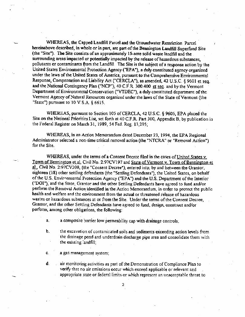
WHEREAS the Capped Landfill Parcel and the Groundwater Restriction Parcel hereinabove described in whole or in part are part of the Bennington Landfill Superfund Site (the Site) The Site consists of an approximately 15-acre solid waste landfill and the surrounding areas impacted or potentially impacted by the release of hazardoussubstances pollutants or contaminants from the Landfill The Site is thesubject of a response action by the United States Environmental Protection Agency (EPA) a duly constituted agency organized under the laws of the United States of America pursuant to the Comprehensive Environmental Response Compensation and Liability Act (CERCLA) as amended 42 USC sect 9601 et seg and the National Contingency Plan (NCP) 40 CFR 300400 et seg and by the Vermont Department of Environmental Conservation (VTDEC) a duly constituted department of the Vermont Agency of Natural Resources organized under the laws of the State of Vermont (the State) pursuant to 10 VSA sect 6615
WHEREAS pursuant to Section 105 of CERCLA 42 USC sect 9605 EPA placed the Site on the National Priorities List set forth at 40 CFR Part 300 Appendix B by publication in the Federal Register on March 31 1989 54 Fed Reg 13295
WHEREAS in an Action Memorandum dated December 23 1994 the EPA Regional Administrator selected a non-time critical removal action (the NTCRA or Removal Action) for the Site
WHEREAS under the terms of a Consent Decree filed in the cases of United States v Town of Bennington et ah Civil No 297CV197 and State of Vermont v Town of Bennington et a] Civil No 297CV208 (the Consent Decree) entered into by and between the Grantor eighteen (18) other settling defendants (the Settling Defendants) the United States on behalf of the US Environmental Protection Agency (EPA) and the US Department of the Interior (DOI) and the State Grantor and the other Settling Defendants have agreed to fund andor perform the Removal Action identified in the Action Memorandum in order to protect the public health and welfare and the environment from the actual or threatened release of hazardous wastes or hazardous substances at or from the Site Under the terms of the Consent Decree Grantor and the other Settling Defendants have agreed to fund design construct andor perform among other obligations the following
a a composite barrier low permeability cap with drainage controls
b the excavation of contaminated soils and sediments exceeding action levels from the drainage pond and underdrain discharge pipe area and consolidate them with the existing landfill
c a gas management system
d air monitoring activities as part of the Demonstration of Compliance Plan to verify that no air emissions occur which exceed applicable or relevant and appropriate state or federal limits or which represent an unacceptable threat to
2
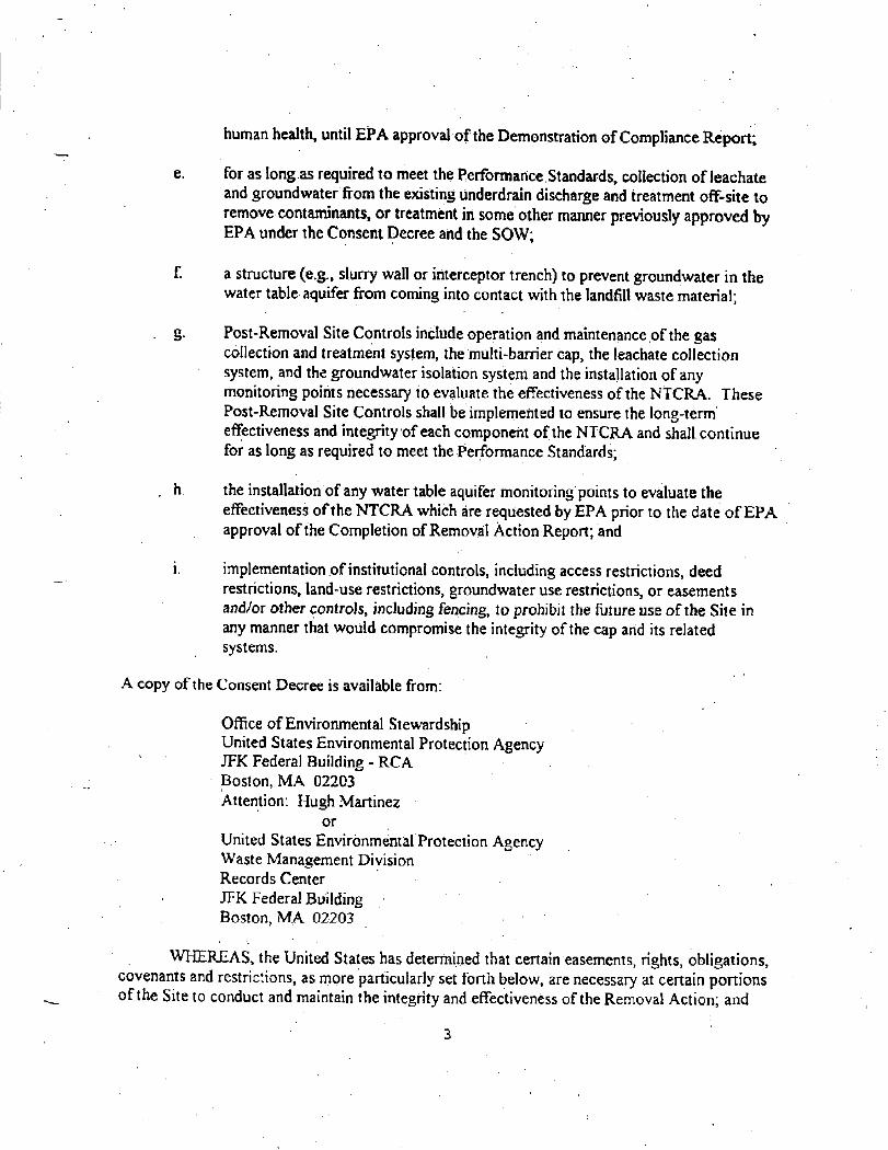
human health until EPA approval of the Demonstration of Compliance Report
e for as long as required to meet the Performance Standards collection of leachate and groundwater from the existing underdrain discharge and treatment off-site to remove contaminants or treatment in some other manner previously approved by EPA under the Consent Decree and the SOW
f a structure (eg slurry wall or interceptor trench) to prevent groundwater in the water table aquifer from coming into contact with the landfill waste material
g Post-Removal Site Controls include operation and maintenance of the gas collection and treatment system the multi-barrier cap the leachate collection system and the groundwater isolation system and the installation of any monitoring points necessary to evaluate the effectiveness of the NTCRA These Post-Removal Site Controls shall be implemented to ensure the long-term effectiveness and integrity of each component of the NTCRA and shall continue for as long as required to meet the Performance Standards
h the installation of any water table aquifer monitoring points to evaluate the effectiveness of the NTCRA which are requested by EPA prior to the date of EPA approval of the Completion of Removal Action Report and
i implementation of institutional controls including access restrictions deed restrictions land-use restrictions groundwater use restrictions or easements andor other controls including fencing to prohibit the future use of the Site in any manner that would compromise the integrity of the cap and its related systems
A copy of the Consent Decree is available from
Office of Environmental Stewardship United States Environmental Protection Agency JFK Federal Building - RCA Boston MA 02203 Attention Hugh Martinez
or United States EnvironmentalProtection Agency Waste Management Division Records Center JFK Federal Building Boston MA 02203
WHEREAS the United States has determined that certain easements rights obligations covenants and restrictions as more particularly set forth below are necessary at certain portions of the Site to conduct and maintain the integrity and effectiveness of the Removal Action and
3
WHEREAS the Grantor agrees to grant the aforesaid easements rights obligations covenants and restrictions as more particularly set forth below to the Grantee pursuant to the Consent Decree
NOW THEREFORE in consideration of the agreements reached in the Consent Decree Grantor hereby grants to the Grantee and its assigns including theEPA with WARRANTY COVENANTS the easements rights obligations covenants and restrictions (hereinafter collectively referred to as the Environmental Restrictions) the terms and conditions of which are as follows
1 Right of Access
a In establishing the within Environmental Restrictions Grantor hereby grants to the Grantee and its assigns including EPA a perpetual right of access (i) in on upon through over and under the portion of the Landfill Parcel described above and (ii) to pass and repass over the Site on the portion of the Landfill Parcel described above for the following purposes
i Monitoring the Removal Action including Operation and Maintenance of the Removal Action and anyfuture response action
ii Verifying any data or information submitted to the United States and the State
shy
iii Conducting investigations relating to the contamination at or near the Site
iv Obtaining samples
v Monitoring the groundwater surface water or air
vi Assessing the need for planning or implementing additional response actions at or near the Site
vii Inspecting and copying records operating logs contracts or other documents maintained or generated by Settling Defendants or their agents consistent with Section XXV of the Consent Decree
viii Assessing Settling Defendants compliance with the Consent Decree and
ix Conducting other investigations and response actions consistent with CERCLA the NCP andor other applicable State or Federal environmental regulations including but not limited to the performance of the Removal Action by the State andor EPA pursuant to Paragraph 95 of the Consent Decree
4
b With respect to the Groundwater Restricted Parcel described above Grantor hereby grants to the Grantee and its assigns including EPA a right of access (i) in on upon through over and under the Groundwater Restricted Parcel and (ii) to pass and repass over the Groundwater Restricted Parcel for thefollowing purposes
-J i Monitoring the Removal Action including Operation and Maintenance of
the Removal Action and any future response action
ii Verifying any data or information submitted to theUnited States and the State
iii Conducting investigations relating to contamination at or near the Site
iv Obtaining samples
v Monitoring the groundwater surface water or air
vi Assessing the need for planning or implementing additional response actions at or near the Site
vii Inspecting and copying records operating logs contracts or other documents maintained or generated by Settling Defendants or their agents consistent with Section XXV of the Consent Decree
viii Assessing Settling Defendants compliance with the Consent Decree and
ix Conducting other investigations and response actions consistent with CERCLA the NCP andor other applicable State or Federal environmental regulations including but not limited to the performance of the Removal Action by the State andor EPA pursuant to Paragraph 95 of the Consent Decree
Grantees right of access under this subparagraph lb shall expire 30 years from EPA approval of the Completion of Removal Action Report under paragraph 52 of the Consent Decree or sooner provided that Grantor has petitioned the Grantee for amendment modification or release of this Grant and such petition is approved by the Grantee pursuant to Paragraph 13 below Grantee may require Grantor to substantiate that such amendment modification or release is appropriate
2 Designation of Restricted Areas The Environmental Restrictions shall apply as set forth below in Paragraph 3 to
5
a the Capped Landfill Parcel e g that section of the land herein restricted which constitutes the cap and the gas collection system as identified in Exhibit A attached hereto and
b the Groundwater Restriction Parcel eg that section of the land herein restricted which includes the leachate collectiontreatment system and the remaining section of the land herein restricted at the Site This area is also identified in Exhibit A attached hereto
Restricted Uses and Activities Grantor shall neither perform nor suffer allow or cause any other person to perform any of the following activities or uses in on upon through over or under those portions of the Landfill Parcel and the Restricted Parcel
a The Capped Landfill Parcel Except pursuant to a plan approved by the Grantee (and by EPA pursuant to the Consent Decree) and in accordance with the procedures set forth in subsection 3 d below no use shall be made which disturbs the integrity of any of the layers ofthe cap the leachate collection system the gas collection system or any other structures for maintaining the effectiveness of the Removal Action whether in place now or put in place in the future Nor shall any use be made which disturbs or interferes with the function of any necessary system for monitoring these structures This restriction shall apply without limitation to all aspects of the cap and related structures identified in Exhibit A
b The Groundwater Restriction Parcel Except pursuant to a plan approved by the Grantee (and by EPA pursuant to the Consent Decree) and in accordance with the procedures set forth in subsection 3d below groundwater within the Groundwater Restriction Area shall hot be used in any manner including but not limited to use as a drinking water supply No groundwater wells shall be installed within the Groundwater Restriction Parcel except for purposes of groundwater monitoring pursuant to a plan approved by the Grantee and EPA
c The Capped Landfill Parcel and the Groundwater Restriction Parcel Except pursuant to a plan approved by the Grantee (and by EPA pursuant to the Consent Decree) and in accordance with the procedures set forth in subsection 3d below there shall be no residential development and no activity or use shall be conducted which adversely impacts the Removal Action or any aspect thereof whether now or in the future including without limitation (1) systems and areas to collect andor contain groundwater surface water runoff or leachate (2) systems or containment areas to excavate dewater store treat andor dispose of soils and sediments and (3) systems and studies to provide long-term environmental monitoring of on-site groundwater surface waters and to ensure the long-term effectiveness of the Removal Action and its protectiveness of human health and the environment
5
d The restrictions in 3a through 3c above shall not apply if and only if for the specific activity planned Grantor first obtains from the Grantee (and by EPA pursuant to the Consent Decree) a written approval to a demonstration by Grantor that the proposed disturbance (a) constitutes a permissible use and will not increase the potential hazard to public health safety or welfare or the environment or (b) is necessary to reduce a threat to public health safety or welfare orlhe environment The VTDEC Commissioner and EPAs Director Site Restoration and Remediation Division shall sign such written approval This approval shall be recorded andor registered by Grantor in the Town of Bennington Land Records within twenty-one (21) days of receipt A certified copy of the same shall be filed with VTDEC and EPA within twenty-one (21) days of the date of its recordation andor registration
e It is recognized and understood that a portion of the Capped Landfill Parcel and the Groundwater Restriction Parcel is comprised of an active facility used as an office and a solid waste transfer station a scale house a leachate collectiontreatment system and as a staging area for recycling and the storagedisposal of leafryard waste (identified as the Active Facility Areas on the Environmental Restrictions Survey Plan) Subject to the limitations in 3a through 3d above the Grantor its successors lessees and assigns shall have the right to continue to use the Capped Landfill Parcel and the Groundwater Restriction Parcel for the purposes listed above or for any other lawful use
4 Applicability The Environmental Restrictions established herein shall not apply to any and all activities or uses in on upon through over or under those portions of the Capped Landfill Parcel and the Groundwater Restriction Parcel situated within the Site or any portion thereof duly authorized or approved by the Grantee pursuant to 10 VSA sect 6615 and the Consent Decree and EPA pursuant to CERCLA and the Consent Decree including without limitation all response actions authorized or approved by the State andor EPA for the Site
Emergency Excavation In the event it becomes necessary to excavate a portion of the Capped Landfill Parcel or the Groundwater Restriction Parcel as part of a response to emergency repair of utility lines or as part of a response to emergencies such as fire or flood the activity and use restriction provisions of Paragraph 3 above which would otherwise restrict such excavation shall be suspended with respect to such excavation for the duration of such response provided that Grantor
a orally notifies the VTDECs Site Manager and EPAs Project Coordinator or in hit or her absence EPAs Alternate Project Coordinator or in the event of both of EPAs designated representatives are unavailable the Director of the Waste Management Division EPA Region I of such emergency as soon as possible but no more than two (2) hours after having learned thereof and follows up with a written notice to VTDEC and EPA and
7
b limits the actual disturbance involved in such excavation to the minimum reasonably necessary to adequately respond to the emergency
This provision shall not waive liability for releases of hazardous substances nor shall this provision excuse compliance with CERCLA or any other applicable federal or state laws and regulations
Severability If any court or other tribunal determines that any provision of this Grant is invalid or unenforceable such provision shall be deemed to have been modified automatically to conform to the requirements for validity and enforceability as determined by such court or tribunal In the event the provision invalidated is of such a nature that it cannot be so modified the provision shall be deemed deleted from this Grant as though it had never been included herein In either case the remaining provisions of this Grant shall remain in full force and effect provided however that the Grantee retains its right to modify this Grant pursuant to Paragraph 13 below
Enforcement Grantor expressly acknowledges that a violation of the terms of this Grant could result in the following
a Upon a determination by a court of competent jurisdiction in the issuance of criminal and civil penalties andor equitable remedies including but not limited to injunctive relief such injunctive relief could include without limitation the issuance of an order to modify or remove any improvements constructed upon those portions of the Capped Landfill Parcel and Groundwater Restriction Parcel situated within the Site in violation of the terms of the within Environmental Restrictions
b In the assessment of penalties and enforcement action by the Grantee or EPA to enforce the terms of the within Environmental Restrictions pursuant to CERCLA and the NCP separate from or in addition to any penalties applicable by virtue of non-compliance with the Consent Decree and
c In the assessment by Grantee of all costs and expenses incurred by the State or EPA in the event of either 7a or 7b above including without limitation attorneys fees
Any action taken by the Grantee or EPA pursuant to this Section shall be in addition to but not in lieu of such rights as EPA andor the State possess to enforce the terms and conditions of the Administrative Order and the Consent Decree which enforcement rights the State and EPA fully reserve
Provisions to Run With the Land These Environmental Restrictions set forth rights liabilities agreements and obligations upon and subject to which the Capped Landfill Parcel and the Groundwater Restriction Parcel or any portion thereof shall be improved held used occupied leased sold hypothecated encumbered or conveyed The rights
8
liabilities agreements and obligations herein set forth shall run with the Capped Landfill Parcel and the Groundwater Restriction Parcel as applicable thereto and any portion thereof and shall inure to the benefit of the Grantee and EPA and their successors and be binding upon Grantor and all parties claiming by through or under Grantor The rights hereby granted to the Grantee and their successors and assigns include the right of Grantee and EPA as its agent to enforce these Environmental Restrictions Grantor hereby covenants for itself and its executors administrators heirs successors and assigns to stand seized and hold title to the Capped Landfill Parcel and the Groundwater Restriction Parcel or any portion thereof subject to these Environmental Restrictions provided however that a violation of these Environmental Restrictions shall not result in a forfeiture or reversion of Grantors title to the Capped Landfill Parcel and the Groundwater Restriction Parcel
9 Grantor Concurrence Grantor and all parties claiming by through or under Grantor covenant and agree with the provisions herein set forth and agree for and among themselves and any party claiming by through or under them and their respective agents contractors sub-contractors and employees that the Environmental Restrictions herein established shall be adhered to and not violated and that their respective interests in the Capped Landfill Parcel and the Groundwater Restriction Parcel shall be subject to the provisions herein set forth
10 Incorporation into Deeds Mortgages Leases and Instruments of Transfer Grantor hereby agrees to incorporate this Grantin full or by reference into all deeds easements mortgages leases licenses occupancy agreements or any other instrument of transfer by which an interest in andor a right to use the Capped Landfill Parcel and the Groundwater Restriction Parcel or any portion thereof is conveyed Any transfer of the Capped Landfill Parcel and the Groundwater Restriction Parcel or any portion thereof shall take place only if the grantee agrees^ as a part of the agreement to purchase or otherwise obtain an interest in the Capped Landfill Parcel and the Groundwater Restriction Parcel that it will comply with the obligations of the Gfantor to provide access andor Institutional Controls as set forth in Section IX of the Consent Decree and this Grant with respect to such Capped Landfill Parcel andor Groundwater Restriction Parcel
11 Recordation Grantor shall record andor register this Grant with the Town of Bennington Land Records within ten (10) days of having received the Grantees written approval of this Grant The Grantor within thirty (30) days of the date of recordation andor registration shall mail a certified Registry copy of this Grant to EPA Project Manager and VTDEC Site Manager
Grantor shall record andor register any amendment to or release of this Grant made pursuant to Paragraph 13 below with the Town of Bennington Land Records within thirty (30) days of having received from the Grantee said amendment or release as agreed to and accepted by or granted by the Grantee and mailed to Grantor by certified mail return receipt requested Grantor shall file with VTDECs and EPAs Site Managers
9
a certified Registry copy of any such amendment or release as recorded andor registered within thirty (30) days of its date of recordation andor registration
This Grant shall become effective upon its recordation andor registration with the Town of Bennington Land Records
12 Legal Notice This Grant shall be published as a legal notice in a form prescribed by the Grantee after a reasonable opportunity for review and comment by EPA within fourteen (14) days of its date of execution in a newspaper which circulates in the community in which the Capped Landfill Parcel and the Groundwater Restriction Parcel are located
Any amendment to or release of this Grant made pursuant to Paragraph 13 below shall be published as a legal notice in a form prescribed by the Grantee after a reasonable opportunity for review and comment by EPA within fourteen (14) days of its date of execution in a newspaper which circulates in the community in which the Capped Landfill Parcel and the Groundwater Restriction Parcel are located
13 Amendment Modification and Release This Grant may be amended modified or released only by the Grantee after a reasonable opportunity for review and comment by EPA in accordance with CERCLA and the NCP to the extent applicable Grantor may submit to EPA and the VTDEC Site Manager a proposal for modifying or withdrawing the Environmental Restrictions or a portion thereof Said proposal shall demonstrate that the Environmental Restrictions contained herein may be modified or withdrawn in whole or in part consistent with the public interest and the public purposes of protecting human health and the environment The Grantee shall issue a written decision with an explanation of the reasons for the approval modification or denial of such petition
Grantor shall pay any and all recording fees land transfer taxes and other such transactional costs associated with any such amendment modification or release
14 No Dedication Intended Nothing herein set forth shall be construed to be a gift or dedication of the Landfill Parcel or the Restricted Parcel to the Grantee or to the general public for any purpose whatsoever
15 Rights Reserved It is expressly agreed that acceptance of this Grant by the Grantee shall not operate to bar diminish or in any way affect any legal or equitable right of the State andor EPA to issue any future order or take response action with respect to the Site or in any way affect any other claim action suit cause of action or demand which the State andor EPA may otherwise possess with respect thereto
16 Filings with Grantee All copies of instruments and documents to be filed with the VTDECs and EPAs Site Managers as required hereunder shall be delivered to the VTDEC and EPA by any of the following methods (i) hand delivery (ii) delivery by overnight mail or (iii) delivery by certified mail return receipt requested
10
17 Governine Law It is expressly agreed that the law of the State of Vermont is the Jaw governing this Grant and any disputes regarding its contents and interpretation
18 Dispute Resolution The dispute resolution procedures of this Paragraph shall be the exclusive mechanism to resolve disputes between the Grantor and Grantee or EPA regarding petitions for amendment modification and release under Paragraph 13 of this Grant
a Informal Negotiations - any dispute under this subparagraph shall in the first instance be the subject of informal negotiations between the parties to the dispute The period for informal negotiations shall not exceed 30 days from the time the dispute arises unless it is modified by written agreement of the parties The dispute shall be considered to have arisen when one party sends the other parties a written Notice of Dispute In the event that the parties cannot resolve a dispute by informal negotiations under this subparagraph then the position advanced by the State after a reasonable opportunity for review and comment by EPA shall be considered binding unless within twenty-one (21) days after the conclusion of the informal negotiation period Grantof invokes the formai dispute resolution procedures by serving on the State with a copy to EPA a written Statement of Position on the matter in dispute including but not limited to any factual data analysis or opinion supporting that position and any supporting documentation relied upon by the Grantor Within twenty-one (21) days after receipt of Grantors Statement of Position the State after a reasonable opportunity for review and comment by EPA will serve on Grantor its Statement of Position including but not limited to any factual date analysis or opinion supporting that position and supporting documentation relied upon by the State
b Formal Dispute Resolution - Formal dispute resolution shall provide for review on the administrative record under applicable principles of administrative law An administrative record of the dispute shall be maintained by the State and shall contain all Statements of Position including supporting documentation submitted pursuant to this subparagraph Where appropriate the State may allow submission of supplemental Statements of Position by themselves or the Grantor The VTDEC Sites Management Section will issue after a reasonable opportunity for review and comment by EPAs Director of the Office of Site Remediation and Restoration New England Region a final administrative decision resolving the dispute based on the administrative record This decision shall be binding upon the Grantor subject only to the right to seek judicial review pursuant to subparagraph 18c below
c Judicial Appeal - Any administrative decision made by the State pursuant to subparagraph 18b shall be reviewable by a Court of competent jurisdiction provided that a notice of judicial appeal is served by the Grantor on the State with a copy to the United States and within 10 days of receipt of the final administrative decision of the State The notice of judicial appeal shall include a
11
description of the matter in dispute the efforts made by the parties to resolve it and the relief requested The State may file within 30 days a response to Grantors notice of judicial appeal In proceedings on any dispute governed by this subparagraph Grantor shall have the burden of demonstrating that the decision of the VTDEC Director of Sites Management Section is arbitrary and capricious or otherwise not in accordance with law Judicial review of the decision by the State shall be on the administrative record compiled pursuant to subparagraph 18b above
IN WITNESS WHEREOF TOWN OF BENNINGTON as record title-holder of the above described lands and premises hereby submits this GRANT OF ENVIRONMENTAL RESTRICTIONS AND RIGHT OF ACCESS which said Grant shall be recorded in the Land Records of the Town of Bennington Vermont
Dated this day of July 1998
Witness Town of Bennington
Name Its Duly Authorized Agent
State of Vermont County of Bennington
On this day of July 1998 personally appeared signer and sealer of the foregoing written conveyance and acknowledged the same to be ) own free act and deed and the free act and deed of the Town of B
bull raquoM laquo P 2s 3 Lt So ccr S I bullbullbull
amplaquoc)Wi^relaquo laquourlaquocr0
- ^bulls2AC(ej bull - Rc f sitcopy- 2S61w i5
oif- iOC A raquoc yV X O t f o n
c-ffic-e of pound E-iyJb A Ifjty JA-C - Oa-frJ jygt-A -bullbull shy
X gte^J Ccm i i (ry -+Ulaquo4 pial Us Ue ^ ^^ b^F p(ib p kKTYmdashlaquopP iUg lnraquoos ^orycirraquoo4e ^laquor^orx ^v oltgt^ltsr 7-sL poundpound757-t e-T lt$ (OUA f (SffWriv^rbV-
Z ^ bull ^-bulls ^7a oV Vpound~^ssp a 7ltapound degf poundltpoundva^lt=gt poundT^oKKSserY XWltL~
2014 FIVE-YEAR REVIEW BENNINGTON LANDFILL SUPERFUND SITE
TABLE OF CONTENTS
EXECUTIVE SUMMARY vii
I INTRODUCTION 1
II PROGRESS SINCE THE LAST REVIEW 2
III FIVE-YEAR REVIEW PROCESS 3
IV TECHNICAL ASSESSMENT 7
V ISSUESRECOMMENDATIONS AND FOLLOW-UP ACTIONS 11
VI PROTECTIVENESS STATEMENTS 11
VII NEXT REVIEW 11
APPENDICES
APPENDIX A EXISTING SITE INFORMATION APPENDIX B PRESS RELEASE ANNOUNCING FIVE-YEAR REVIEW APPENDIX C TABLES APPENDIX D FIGURES APPENDIX E RECORD OF INTERVIEWS APPENDIX F SITE INSPECTION LOG AND PHOTOS APPENDIX G AMBIENT MONITORING TRANSER LETTER APPENDIX H GRANT OF ENVIRONMENTAL RESTRICTIONS AND RIGHT OF
ACCESS
iii
LIST OF ACRONYMS
ARAR Applicable or Relevant and Appropriate Requirement
CERCLA Comprehensive Environmental Response Compensation and Liability Act
EPA United States Environmental Protection Agency
CFR Code of Federal Regulations
CWA Clean Water Act
FYR Five-Year Review
GAC Granular activated carbon
HAAS Hazardous ambient air standards
IC Institutional control
IPC Influent pump chamber
LCTS Leachate collection treatment systems
LTMP Long-term monitoring plan
MCL Maximum Contaminant Level
MCLG Maximum Contaminant Level Goal
MW Monitoring well
NCP National Contingency Plan
NFA No Further Action
NPL National Priorities List
NTCRA Non-Time Critical Removal Action
OampF Operational and functional
OampM Operation and Maintenance
OU Operable Unit
PCB Polychlorinated Biphenyls
PCE 1 Tetrachloroethylene
PCOR Preliminary Close-Out Report
PRP Potentially Responsible Party
RA Remedial Action
RAO Remedial Action Objective
RD Remedial Design
RIFS Remedial InvestigationFeasibility Study
ROD Record of Decision
TAL Target analyte list
TCA 111-trichloroethane
TCE trichloroethylene
iv
TCG Target Cleanup Goals
VGES Vermont Groundwater Enforcement Standards
VOC Volatile Organic Compound
VT DEC Vermont Department of Environmental Conservation
VT DOH Vermont Department of Health
VTGWES Vermont Groundwater Enforcement Standard
UgL Microgram per Liter
v
EXECUTIVE SUMMARY
This is the third Five-Year Review (FYR) for the Bennington Landfill Superfund Site (Site) located at Houghton Lane Bennington VT The purpose of this FYR is to review information to determine if the remedy is and will continue to be protective of human health and the environment The methods findings and conclusions of these reviews are documented in the FYR Reports In addition FYR Reports identify issues found during the review if any and recommendations to address them
The Non-Time Critical Removal Action (NTCRA) for the Site included excavation and on-site disposal of contaminated soils a multi-layer landfill cap drainage controls passive gas vents an interceptor trench for surface and ground water groundwater and leachate collection and on-site treatment long-term monitoring and institutional controls A 1998 Record of Decision (ROD) made the final remedial decision that no further action (NFA) beyond the NTCRA was required at the Site to protect human health and the environment The Site achieved construction completion on June 30 1999 In the ROD EPA also determined that it would conduct FYRs of the Site as a matter of policy The first of these reviews was signed on September 21 2004 the second was signed on September 11 2009 and is the trigger date for this third five-year review report The VT Department of Environmental Conservation (VT DEC) has reviewed and provided input into this FYR report
This third FYR found that the remedy is constructed in accordance with the requirements of the NTCRA Action Memorandum Consent Decree (CD) and (ROD) The remedy is functioning as designed the response actions are protective and thus the remedy at this Site is protective of human health and the environment
Five-Year Review Summary Form
Lead agency EPA
Author name (Federal or State Project Manager) Almerinda Silva
Author affiliation EPA
Review period 1292014 -9112014
Date of site inspection June 6 2014
Type of review Policy
Review number 3
Triggering action date 9112009
Due date (fiveyears after triggering action date) 9112014
Protectiveness Statement(s)
Operable Unit Site Wide Protectiveness Determination OU1ampOU2 Protective
Protectiveness Statement Contamination at the Site has been addressed through excavation and on-site disposal of contaminatedsoil capping of contaminated soil on-site a leachate and groundwater collection system on-site treatment of contaminated groundwater and leachate gas collection vents and institutional controls thus there is no exposure of Site related waste to humans or the environment at levels that would represent a health concern Operation and maintenance activities and regular oversight inspections ensure that the remedy remains effective and the Site is protective of human health and the environment
Vll
I INTRODUCTION
The purpose of a Five-Year Review (FYR) is to evaluate the implementation and performance of a remedy in order to determine if the remedy will continue to be protective of human health and the environment The methods findings and conclusions of reviews are documented in FYR reports In addition FYR reports identify issues found during the review if any and document recommendations to address them
The US Environmental Protection Agency (EPA) prepares FYRs pursuant to the Comprehensive Environmental Response Compensation and Liability Act (CERCLA) Section 121 and the National Contingency Plan (NCP) CERCLA 121 states
If the President selects a remedial action that results in any hazardous substances pollutants or contaminants remaining at the site the President shall review such remedial action no less often than each five years after the initiation ofsuch remedial action to assure that human health and the environment are beingprotected by the remedial action being implemented In addition if upon such review it is the judgment of
the President that action is appropriate at such site in accordance with section [104]or [106] the President shall take or require such action The President shall report to the Congress a list offacilitiesfor which such review is required the results of all such reviews and any actions taken as a result ofsuch reviews
EPA interpreted this requirement further in the NCP 40 Code of Federal Regulations (CFR) Section 300430(f)(4)(ii) which states
If a remedial action is selected that results in hazardous substances pollutants or contaminants remaining at the site above levels that allowfor unlimited use and unrestricted exposure the lead agency shall review such actions no less often than every five years after the initiation of the selected remedialaction
The EPA conducted this FYR of the response actions implemented at the Bennington Landfill Superfund Site (Site) in Bennington VT This review was conducted from January 29 2014 through September 2014 The FYR included consultation with the VT Department of Environmental Conservation (VT DEC) This report documents the results of the review
This is the third FYR for the Site There are two operable units (OUs) at the Sitea non-time critical removal action (NTCRA) and a no further action (NFA) remedial decision Operation and maintenance continues at the Site Therefore this FYR addresses the status of the Site response actions in their entirety and considers components of both the NTCRA and the final remedial decision The triggering action for this policy review is the date of the previous FYR Report signed on September 11 2009 This policy review is conducted because hazardous substances pollutants or contaminants remain on-site above levels that allow for unlimited use and unrestricted exposure
1
II PROGRESS SINCE THE LAST REVIEW
The second Five-Year Review Report was signed on September 11 2009 and found the Site to be protective in the short and long-term
Protectiveness DeterminationsStatements from the 2009 FYR
Because the response actions at the entire Site are protective the Site is protective of human health and the environment Contamination at the Site has been addressed through excavation and on-site disposal of contaminated soil capping of contaminated soils on-site a leachate and groundwater collection system on-site treatment of contaminated groundwater and leachate gas collection vents and institutional controls Operation and maintenance activities and regular oversight inspections ensure that the remedy remains effective and the Site is protective of human health and the environment
Status of Issues and Recommendations from the 2009 FYR
There were no issues that affected current or future protectiveness identified in the 2009 FYR The Site inspection conducted during the 2009 FYR did identify several minor maintenance issues requiring attention which include
bull burrow holes and other areas of animal disturbance bull areas of mower damage that needed to be filled and seeded bull small trees and bushes near the perimeter of the landfiil cap extension that needed to be removed bull areas of subsidence and depressions that needed to be watched for increases in settling bull soil loss and settling along the northeastern perimeter ditches that needed filling seeding and
watch for future cap stability bull sediment was observed at the outlet pipe openings in the perimeter ditch near the northeast corner
of the landfill that needed to be removed periodically bull the gabions needed to continue to be monitored for evidence of overturning or other instability
especially in the area of the gabion retaining wall where the bulging has been noted in previous inspections and
bull monitoring should be done on a monthly basis or more frequently in time of high precipitation
All of these maintenance issues have been and continue to be promptly addressed as the need arises
An additional recommendation listed below that does not affect the protectiveness of the Site was identified in the 2009 FYR
The recommendation listed here simply transfers ambient monitoring responsibility from the EPA to the VT DEC as required per the Memorandum of Agreement dated August 2001 between the US EPA and VT DEC
bull Transfer of ambient monitoring responsibility from the US EPA to VT DEC is documented in a letter dated September 9 2014 from Mr Chuck Schwer Section Chief of the Sites Management Section with the VT DEC to Mr Michael Jasinski Section Chief of MEVTCTNHRI Superfund Section with the US EPA (See Appendix G for copy of this letter)
2
Remedy Implementation Activities
No remedy implementation activities other than O amp M took place during this FYR period
System OperationOperation and Maintenance Activities
Long-term monitoring of groundwater surface water and sediment has continued during the period covered by this review (Fall 2009 to Summer 2014) Operation and maintenance activities continue to be performed by the Town of Bennington on a regular and timely basis
III FIVE-YEAR REVIEW PROCESS
Administrative Components
The Town of Bennington who is the PRP for the Site and the VT DEC were notified of the initiation of the FYR on January 29 2014 This FYR was led by Almerinda Silva the EPA Remedial Project Manager and John Schmeltzer the VT DEC Project Manager assisted in the review
The review which began on January 29 2014consisted of the following components
bull Community Notification and Involvement bull Document Review bull Data Review bull Site Inspection and bull Five-Year Review Report Development and Review
Community Notification and Involvement
Activities to involve the community in this five-year review process were initiated with a discussion in January 2014 between the Remedial Project Manager and Community Involvement Coordinator for the Site Per Region 1 policy a region-wide press release announcing all upcoming five-year reviews in New England was sent to all regional newspapers including the Bennington Banner The press release was sent on February 13 2014 and is attached in Appendix B The results of the review and the report will be made available at the Site information repository located at
Bennington Town Hall 205 South Street Bennington VT 05201
and at
US Environmental Protection Agency 5 Post Office Square Suite 100 Boston MA 02109-3912 3 v
Document Review
This five-year review consisted of a review of relevant documents including monitoring data Applicable groundwater surface water and sediment cleanup standards as listed in the 1998 Record of Decision and the Grant of Environmental Restrictions and Right of Access which describes institutional controls (See Appendix H for detail) were also reviewed
Data Review
A summary evaluation of groundwater surface water and sediment sampling results is presented below A No Further Action final Record of Decision (ROD) was signed in October 1998 which summarized the basis for the No Further Action (NFA) According to the ROD the NTCRA (ie landfill cap interceptor trench along with all of the other landfill cap components) resolved the exposure pathways with the exception of groundwater The ROD went on to say that the NTCRA institutional controls (ICs) will effectively prevent use of the contaminated groundwater at the Site Therefore the establishment of cleanup standards was not required for groundwater surface water or sediment Long-term monitoring is being performed to document that conditions documented in the Remedial InvestigationFeasibility Study (RIFS) and used as the basis for the NFA do not change Site-Specific Target Cleanup Goals (TCGs) were established for the long-term monitoring as a basis for evaluation of groundwater data The TCGs are the more stringent of the Maximum Contaminant Levels (MCLs) established by the Federal Safe Drinking Water Act or State of Vermont Groundwater Enforcement Standards (VTGWES) Contaminants of Concern (COCs) for the Site include metals (arsenic barium and manganese) and PCBs that have exceeded VTGWES and MCLs during long-term monitoring of Site groundwater Historically other metals that have been detected at the Site no longer exceed the TCGs Site groundwater monitoring wells surface water and sediment sampling locations are shown on Figure 2
Groundwater
According to the last FYR in 2009 groundwater data had indicated stable or decreasing trends in downgradient well contaminant levels Additionally at the time of the 2009 FYR the extent of downgradient metals and PCB impacts did not appear to be expanding beyond historic limits
Since the 2009 FYR groundwater surface water and sediment samples have been collected as part of the long-term monitoring required by the 1998 ROD In September 2009 groundwater samples were analyzed for volatile organic compounds (VOCs) semi-volatile organic compounds (SVOCs) metals and PCB homologs Surface water and sediment samples were analyzed for metals and PCB homologs In July 2010 groundwater surface water and sediment samples were analyzed for metals and PCB homologs In December 2013 groundwater surface water and sediment samples were also analyzed for metals and PCB homologs
A review of the results of September 2009 sampling indicates no VOCs or SVOCs were detected above the VTGWESMCL and most results were below laboratory detection limits Arsenic and manganese
4
concentrations were detected in exceedance of VTGWESMCL in several wells for both total and dissolved metals including well B-19 The highest concentration of arsenic (276 ugL) was detected at B-23 The highest concentration of manganese (3000 ugL) was detected at PZ-1 Groundwater samples were also analyzed for PCB homologs and samples from six of twenty-two wells contained PCBs at concentrations greater than 05 ugL The highest concentration (413 ugL) was detected at Bshy5-2
Twenty-two groundwater samples collected during July 2010 were only analyzed for metals and PCBs Arsenic and manganese concentrations were detected above the VTGWESMCL at most wells in both total and dissolved metals samples The highest arsenic concentration (921 ugL) was detected at B-2shy2 The highest manganese concentration (1953 ugL) was detected at B-19 Groundwater samples from five of twenty-two wells contained PCBs at concentrations greater than the target cleanup goal (TCG) of 05 ugL The highest concentration (209 J ugL) was detected at B-5-2
In 2013 groundwater samples were collected from 10 wells and analyzed for only total metals and PCB homologs Arsenic was not detected at concentrations exceeding the VTGWES however the detection limit was set at 20 ugL therefore concentrations were less than the detection limit but potentially higher than the VTGWES of 10 ppb Manganese concentrations were detected at concentrations above the VTGWES of 300 ppb (an MCL does not exist) in six of the ten wells sampled located upgradient from the landfill where manganese was 4-6 times higher than the VTGWES Total PCB concentrations did not exceed the 05ugL TCG
In summary concentrations of VOCs SVOCs metals and PCB homologs were within the historic range for samples collected as part of the RIFS and the 2006 long-term monitoring sample round with the exception of arsenic in the sample collected from well B-2-2 on July 26 2010 which was slightly higher than the historic range of concentrations The location and number of wells sampled as part of the long-term monitoring provide sufficient coverage to monitor the location and concentrations of the contaminated plume PCBs found were all located east of the edge of the landfill Based on the analytical data for the samples collected since the last FYR it appears that the contaminant plume has not expanded beyond its historic limits and it remains within the IC zone Concentrations of COCs detected in samples collected in 2009 2010 and 2013 are shown on Figure 3 in Appendix D and listed on Table 1 listed in Appendix C
Surface Water
Surface water samples have been collected as part of the long-term monitoring from wetlands and Hewitt Brook located hydraulically down gradient of the landfill According to the last FYR in 2009 surface water samples had only been collected in 1999 and 2000 up to that time Results of metals and PCBs were compared to RIFS data and concentrations were consistent As a result EPA determined surface water sampling was no longer necessary based on these unchanged conditions
Surface water sampling was reinstated as part of the long-term monitoring of the Site in 2009 Results of surface water samples collected in 2009 and 2010 indicated concentrations of metals were generally within the historic range detected in the RIFS with the exception of arsenic (591 ugL) and barium (2140 ugL) in the sample collected from SW-05 on September 18 2009 which were slightly higher than the historical range for samples collected as part of the Remedial Investigation In 2013 one surface water sample was collected at SW-02 which is immediately upstream from the Site boundary to
5
the east Concentrations of COCs in the2013 sample collected from SW-02 were lower than the 2010 sampling event and within the historic range of concentrations for surface water detected during the RI In general concentrations of COCs in surface water decrease with distance downstream of the landfill Concentrations of COCs detected in samples collected in 2009 2010 and 2013 are shown on Figure 4 in Appendix D and listed on Table 2 in Appendix C
Sediment
Sediment samples have been collected as part of long term monitoring from wetlands and Hewitt Brook located hydraulically down gradient of the landfill At the time of the last FYR in 2009 sediment samples had only been collected in 1999 In general the concentrations of PCBs were comparable to RIFS data Arsenic barium and iron were detected at higher concentrations however EPA concluded the concentrations did not pose an increased risk to human health or the environment As a result sediment sampling was discontinued
Sediment sampling was reinstated as part of the long-term monitoring of the Site in 2009 Numerous metals were detected in the sediment samples collected in September 2009 July 2010 and December 2013 Currently there are no standards for metals in sediments at the Site however these results are comparable to historical RIFS data and October 1999 long-term monitoring data The maximum concentrations of arsenic (156 mgkg) barium (4320 mgkg) and manganese (27600 ugL) were detected in thesample from SED-08 on September 18 2009 Concentrations of total PCB homologs were less than the NTCRA cleanup criteria of 1000 ugkg in long-term monitoring sediment samples collected in 2009 2010 and 2013 In general concentrations of COCs in sediment decrease with distance downstream of the landfill Concentrations of COCs detected in samples collected in 2009 2010 and 2013 are shown on Figure 5 and listed on Table 3
Site Inspection
The inspection of the Bennington Landfill was conducted on June 6 2014 In attendance were Almerinda Silva EPA Remedial Project Manager Michael Jasinski EPA MEVTCT amp NHRI Section Chief and Greg Michele Nobis Engineering Inc consultant to EPA Also in attendance were John Schmeltzer and James Surwilo representing VT DEC The purpose of the inspection was to assess the protectiveness of the remedy The inspection team walked the surface of the landfill and observed the condition of the landfill cap storm water drainage structures and gas vents Due to a significant reduction in the flow from the former landfill underdrain pipe the leachate collection treatment system (LCTS) installed to treat the landfill leachate was deactivated in 2008 and has not been used since that time Therefore the LCTS was not inspected A checklist was prepared during the inspection and photographs were taken to document the condition of the landfill all of which are presented in Appendix F
The landfill appeared to be in good condition on the date of the inspection The vegetated landfill surface was in good condition with no evidence of significant settlement erosion or damage Landfill gas vents and storm water drainage structures were observed to be in good working condition Several minor issues were identified during the inspection including
6
bull Several shallow holes less than 12 inches deep were observed on the eastern side of the landfill that may be animal burrows
bull Minor vegetation was observed growing in storm water drainage structures including slope benches and perimeter ditches
bull Woody vegetation was observed growing adjacent to the toe of the landfill cap and drainage structures in several locations
The Town should continue monitoring for and remove any burrowing animals found on the landfill Sediments and vegetation should be removed from drainage structures if the flow of storm water is impeded Woody vegetation growing adjacent to the landfill cap should be removed periodically These items can be addressed as part of the routine operation and maintenance and do not affect the protectiveness of the landfill cap system Changes in the use of the Site were not observed that would be inconsistent with the ICs place on the Site property
Interviews
During the FYR process interviews were conducted by Almerinda Silva EPA Remedial Project Manager with parties impacted by the Site These parties included Stuart Hurd Manager for the Town of Bennington and PRP representative John Schmeltzer VT DEC Project Manager Steve Bruso resident and Site gate keeper Dale Baker Manager for Cassella Waste Management and Brenda Rowland resident The purpose of the interviews was to document any perceived problems or successes with the remedy that has been implemented to date Interviews were conducted during the month of July 2014 The general consensus was that the Site was functioning as intended and being maintained properly No one had questions or concerns The record of interviews is included in Appendix E
IV TECHNICAL ASSESSMENT
QUESTION A Is the remedy functioning as intended by the decision documents
Yes
RemedialAction Performance
The long-term monitoring data and oversight inspections confirm that the NTCRA is functioning as intended and that the No Further Action ROD monitoring program is being implemented The information sources include review of the available documents review of post NTCRA monitoring data the interviews and the Site inspection The landfill cap and the leachate collection treatment system (LCTS) have achieved the remedial objectives to minimize the migration of contaminants and prevent direct contact with or ingestion of contaminants
7
Evidence to indicate that the remedy is performing as intended includes the following
bull The remedial objectives of the cap have been achieved by preventing direct exposure to waste and contaminated soils All waste materials consolidated under the cap as part of the NTCRA were placed at least 30 feet above the groundwater table to ensure there would be no further impact to area groundwater
bull There is no indication that the cap is leaking therefore the objective of reducing or eliminating the generation of landfill leachate has been met The cap is maintained and inspected by the Town of Bennington The Town is responsible for repair work at the landfill
bull At the time of this FYR the landfill cap and upgradient groundwater isolation system appear to be functioning as designed and in good overall condition The surface of the landfill remains stable and shows no signs of erosion or cracks The benches in the landfill surface are also functioning as designed and in good overall condition Perimeter ditches remain in good overall condition and operating as designed The outlet pipes and riprap outlet of the drainage layer at the perimeter of the cover system remains in good overall condition The upgradient groundwater isolation system continues to function as designed and requires minimal maintenance
bull Construction of the landfill cap and leachate collection system were designed to eliminate the discharge of contaminants to surface water receptors With continued maintenance of the landfill cap and decommissioning of the leachate collection system in 2008 future compliance regarding surface water and sediments can be expected without additional remedial action
System OperationsOampM
bull The operation and maintenance of the cap and the decommissioning of the leachate collection system has been and continues to be effective Issues identified during semi to annual inspections are regularly addressed or continue to be monitored The current sampling and analytical methods for groundwater surface water and sediment are adequate to evaluate the performance of the remedy The location and number of wells sampled give sufficient coverage to monitor the location and concentrations of the contaminated plume within the IC zone
Opportunitiesfor Optimization
bull EPA in consultation with VT DEC has reduced the number of wells to be sampled and the monitoring frequency to every five years unless a reason arises in the future that necessitates an increase in monitoring
Early Indicators of Potential Issues
bull There have not been any indicators of potential issues (such as IC non-compliance) since the last FYR
Implementation of Institutional Controls and Other Measures
bull A restrictive covenant has been placed on the property to prevent the use of contaminated groundwater and disturbance to the cap and its appurtenances The impacted groundwater has been reclassified as non-potable to further prevent future use No activities were observed that would have violated the institutional controls ICs ensure that the risk of exposure is low by preventing use of groundwater and any land activities that could threaten the effectiveness of the landfill cap and remedy as well as to protect against risk to human health and the environment
QUESTION B Are the exposure assumptions toxicity data cleanup levels and remedial action objectives (RAOs) used at the time of the remedy section still valid
No Although there have been changes in exposure assumptions and risk assessment methods since the risk assessments were conducted to support the 1998 ROD the changes do not affect the remedy protectiveness as discussed below
Changes in Standards and TBCs
As discussed in the 2009 FYR the MCL for arsenic was updated from 50 ppb to 10 ppb in 2002 There have been no other changes to the COCs identified in the February 1998 Risk Assessment As no groundwater cleanup levels were identified for the Site in the No Further Action ROD and institutional controls prevent the use of groundwater the new arsenic MCL does not affect the protectiveness of the remedy
Changes in ExposurePathways
For groundwater the exposure assumptions used to develop the ROD focused on the groundwater ingestion pathway potential dermal contact with groundwater used as a household water source and inhalation of volatiles during household water use were not evaluated However these pathways presently are not a concern because institutional controls prevent residential development installation of groundwater wells and use of groundwater for any purpose In addition based on the analytical data collected for the samples collected since the 2009 five-year review the contaminant plume has not expanded beyond its historical limits and COCs identified in the 1998 Risk Assessment do not appear to be migrating off site
The vapor intrusion pathway was not evaluated in the 1998 ROD The current and future land use of the landfill itself is considered non-residential because of the institutional controls which prevent
9
constructing residences on the landfill The areas surrounding the landfill are considered residential however the residences are not currently located in close proximity to the predicted location of the plume The transfer station adjacent to the landfill is not an enclosed structure and therefore any potential future vapor intrusion pathway for this building is not complete
Changes in Toxicity
There have been no changes to the toxicity values of the COCs identified in the February 1998 Risk Assessment since the 2009 FYR
Changes in Risk Assessment Methods
In 2014 EPA finalized a Directive to update standard default exposure factors and frequently asked questions associated with these updates httpwwwepagovoswerriskassessmentsuperfund hh exposurehtm (items 22 and 23 of this web link) Some of these exposure factors differ from those used in the risk assessments for the 1998 ROD These changes in general would result in a slight decrease of the risk estimates for most chemicals Also note that changes in exposure factors for the groundwater exposure pathway that have occurred since the 1998 ROD do not affect the remedy because of its reliance on institutional controls incorporated during the NTCRA which prevent residential development installation of groundwater wells and use of groundwater for any purpose
Expected Progress Towards Meeting RAOs
The remedy is progressing as expected Data indicate that the landfill cap and isolation trench are effective at preventing infiltration of water through the solid waste mass Decommissioning of the LCTS in 2008 is another measure that leachate has been significantly reduced thus is not negatively impacting the shallow unit of groundwater downgradient of the landfill Cleanup goals for arsenic iron manganese and PCBs are not fully met Flowever the contaminant plume has not expanded its extent either horizontally or vertically indicating that the remedy is effective at preventing the spread of site-related contamination There are no ARARs established at this Site and this FYR found no appreciable changes from the last two FYRs In addition ICs ensure that risk of exposure is low by preventing use of groundwater and any land activities that could threaten the effectiveness of the landfill cap and remedy as well as protect against risk to human health or the environment
QUESTION C Flas any other information come to light that could call into question the protectiveness of the remedy
No
10
Technical Assessment Summary
According to the data reviewed the Site inspection and the interviews the remedy is functioning as intended by the NTCRA Action Memorandum and ROD There have been no changes in the physical conditions of the Site that would affect the protectiveness of the remedy There have been no significant changes to the overall exposure assumptions used in evaluating human health and ecological risk Because the Site is a no further action there are no ARARs set in the 1998 ROD at this Site There is no other information that calls into question the protectiveness of the remedy
V ISSUESRECOMMENDATIONS AND FOLLOW-UP ACTIONS
There are no issues which affect the protectiveness of the remedy For continued protection and effectiveness of remedy implementation regular OampM should be continued by the Town of Bennington with oversight by VT DEC and EPA
While there are no protectiveness issues at this time it is possible that conditions not addressed by continued and timely OampM could potentially affect protectiveness in the future Future remedy protectiveness would only be affected if the OampM is not consistent at or above the level conducted at present
VI PROTECTIVENESS STATEMENTS
Protectiveness Statement(s)
Operable Unit Protectiveness Determination Addendum Due Date Operable Unit OU1 ampOU2 Site Wide Protectiveness Statement (if applicable)
Click here to enter a date
Protectiveness Statement Contamination at the Site has been addressed through excavation and on-site disposal of contaminated soil capping of contaminated soil on-site a leachate and groundwater collection system on-site treatment of contaminated groundwater and leachate gas collection vents and institutional controls thus there is no exposure of Site related waste to humans or the environment at levels that would represent a health concern Operation and maintenance activities and regular oversight inspections ensure that the remedy remains effective and the Site is protective of human health and the environment
VII NEXT REVIEW
The next five-year review report for the Bennington Landfill Superfund Site is required five years from the signature date of this review in 2019
11
APPENDIX A
Existing Site Information
APPENDIX A -EXISTING SITE INFORMATION
A SITE CHRONOLOGY
Table 1 Chronology of Site Events
Date Event
prior to 1969 Site run as a sand and gravel operation
1969-1985 Site leased by the Town of Bennington as a municipal solid waste and industrial dump
1969-1975 Portion of the site used as a liquid waste lagoon
1987 Landfill closed
March 31 1989 NPL listing
1990 State solid waste closure performed by the Town of Bennington
1991 Remedial Investigation (RI) begun
December 23 1994 Action Memorandum to initiate Non-Time Critical Removal Action (NTCRA) signed
November 26 1996 Administrative Order on Consent (AOC) for NTRCA design signed
December 1996 NTCRA design phase begins
August 18 1997 Consent Decree for construction and maintenance of NTCRA signed
September 1997 NTCRA construction begins
December 23 1997 RI completed
July 1 1998 Restrictive covenant and groundwater reclassification for landfill and area of groundwater impact implemented
September 29 1998 Record of Decision signed
1998 Maintenance and monitoring
June 30 1999 NTCRA construction completed PCOR signed
September 21 2004 First Five-Year Review Report signed
2004-2009 Ongoing Site monitoring maintenance and inspections
September 11 2009 Second Five-Year Review signed
14
August 2014 Long-Term Monitoring Transferred from EPA to VT DEC
September 2014 Third Eive-Year Review signed
B BACKGROUND
Physical Characteristics
The Site consists of a 15-acre municipal solid waste landfill and associated drainage pond situated in an 85-acre parcel owned by the Town of Bennington Vermont Prior to the landfill the location of the Site was a sand and gravel pit The areas to the north and east of the Site are former borrow pits The area directly east of the Site is wetlandwoodland that is within the groundwater institutional control area and is unlikely to be developed in the future The other areas surrounding the Site are residential The Site is bordered by wetlands serving as headwaters for Hewitt Brook to the east of the Site residential areas are to the south and US Route 7 to the west The 2006 US Census Bureau population estimate for the Town of Bennington is 36382
Hydrology
There are two groundwater systems at the Site The shallow system is comprised of a surficial sand and gravel unit that ranges in thickness from 7 to 29 feet The saturated thickness of the sand and gravel unit increases with the thickness of the unit The surficial sand and gravel unit is underlain by a dense glacial till This unit was consistently dry during drilling and has been characterized as a confining layer The till layer thickness ranges from 0 feet west of the landfill to 530 feet east of the landfill
The bedrock and a deep sand and gravel unit represent the second water bearing formation at the Site This unit is separated from the surficial sand and gravel unit by the till layer Bedrock is exposed in several locations upgradient of the landfill limiting the horizontal extent of the surficial sand and gravel unit Groundwater flow in the surficial sand and gravel unit is predominantly west to east with the headwaters of Hewitt Brook serving as a discharge zone for the groundwater This is confirmed by the pattern of groundwater contamination
Land and Resource Use
There were no zoning or other land use restrictions in place at the start of the remedial investigation and feasibility study (RIFS) that would have precluded future residential use of the Site The restrictive covenant implemented by the Town of Bennington and State of Vermont as part of the NTCRA prohibits residential development and helps prevent exposure to contaminated soil and groundwater Landfill use decisions in Bennington County are made by the Bennington County Regional Planning
15
Commission in accordance with their Regional Plan (most recent is May 17 2007)
A solid waste transfer station and recycling center are currently located adjacent to the landfill This transfer station accepts mixed solid waste and recyclables It is operated by Casella Waste Management
To compensate for Natural Resource Damages at the Site the US Fish and Wildlife Service and the Town of Bennington conducted a wetland restoration project approximately 3 miles southeast of the Site on Burgess Road An antiquated water collection system of concrete cisterns and underground pipes was removed to restore natural hydrologic conditions The restoration project was completed in 1998 with monitoring through 2001 The project restored 28 acres of wetland and protected 14 acres of wetland and upland in perpetuity via a conservation covenant as required by the 1997 Consent Decree
In addition as compensation for Natural Resource Damages at two other Superfund Site (the Burgess Brothers Landfill and the Tansitor Electronics Site) the US Fish and Wildlife Service has restored 2 acres of wetland and 7 acres of grassland immediately adjacent to the Bennington Landfill Superfund Site This effort was completed in partnership with the Town of Bennington and the USDA Natural Resource Conservation Service
History of Contamination
The landfill began operations in 1969 and received commercial residential and industrial solid and liquid wastes The Town of Bennington leased the property for use as a landfill until 1985 when the Town purchased the property In April 1987 the landfill was closed and the Town established a transfer station adjacent to the landfill
Throughout the entire period of operation (1969 - 1987) residential industrial and commercial waste was disposed in the landfill One portion of the landfill was used for disposal of liquid wastes from 1969 -1975 This area known as the lagoon was covered with debris and is within the limits of the current solid waste mass A drainage system was constructed within the landfill in 1976 to lower the groundwater level in the waste The outlet for this drainage system was a pipe the discharge from which was responsible for the creation of the drainage pond
The Town of Bennington performed a solid waste closure of the landfill in 1990 in accordance with the Vermont Solid Waste Program Collection of the underdrain discharge was not included in the solid waste closure
The surficial sand and gravel aquifer was impacted by the landfill PCBs VOCs (including vinyl chloride chloroethane 11-dichloroethene 12-dichloroethene 111-trichloroehtane trichoroethene methylene chloride and benzene) and several metals (arsenic barium and manganese) were detected at elevated levels Elevated levels of PCBs were also found in the soil and sediment of a small area of standing water near the outlet to the discharge from the drainage pipe
The contamination of the surficial sand and gravel aquifer extended from under the landfill to the area to the east where groundwater recharges the wetland serving as headwaters for Hewitt Brook Elevated levels of contaminants were detected in wells abutting the landfill and dropped significantly within several hundred feet of the landfill There was an increase in arsenic with distance from the landfill that was likely a results of the mobilization of arsenic from natural soil materials due to a reducing environment created by the presence of landfill leachate Very low levels of VOCs were detected in the
16
bedrock aquifer adjacent to the landfill High levels of PCBs were found in the soil and sediment adjacent to the discharges from the underdrain discharge pipe Some of the PCBs migrated into the sediments of the wetland and of Hewitt Brook
Initial Response
In December 1994 EPA signed an Action Memorandum to initiate a non-time-critical removal action (NTCRA) at the Site to address the source of contamination The NTCRA was designed to control the source of contamination to groundwater surface water and sediment The major components of the NTCRA are
bull Construction of a multi-barrier landfill cap over the entire waste mass bull Construction of an upgragdient interceptor trench to divert groundwater upgradient of the
landfill around the waste bull Construction of a leachate collection and treatment system to collect and treat discharge
from the underdrain discharge pipe and bull Excavation and consolidation of sediments and soils with PCB concentrations above 1
milligram per kilogram (mgkg)
The NTCRA also included ICs to prevent future use of the Site EPA entered into an Administrative Order with the potentially responsible parties (PRPs) for the design of the NTCRA in 1996 EPA and the PRPs entered into a CD in August 1997 The CD required the PRPs to perform construction activities implement ICs and perform long-term post-removal Site control (PRSC) All construction activities and ICs included in the NTCRA were completed in June 1999
Basis for Taking Action
The initial cleanup action was taken to address the PCB contamination in sediment adjacent to the landfill and to comply with federal and state landfill closure requirements The Human Health and Ecological Risk Assessment (HHERA) concluded that there was not an unacceptable risk to human health or the environment after completion of the NTCRA
C REMEDIAL ACTIONS
Remedy Selection
A ROD selecting no further action was signed in September 1998 This ROD records the final remedy decision for the Site Based on the RIFS HHERA and monitoring results upon the completions of the NTCRA the ROD determined that no further remedial action was required at the Site to ensure protectiveness of human health and the environment The ROD did include a long-term monitoring requirement to confirm that conditions upon which the remedy decision was based do not change EPA is responsible for monitoring activities during the first 10 years (December 1999 shyDecember 2009) of the Sites post construction life and the State of Vermont is responsible for the
17
remainder
Remedy Implementation
The long-term monitoring required by the ROD is being implemented by EPA The NTCRA construction activities and ICs were completed in June 1999 The cleanup actions implemented by the NTCRA are operated and maintained by the Town of Bennington in accordance with the Action Memorandum and the 1997 CD with EPA providing oversight
Institutional Controls
ICs are non-engineered instruments such as administrative andor legal controls that help minimize the potential for exposure to contamination and protect the integrity of the remedy Compliance with ICs is required to assure long-term protectiveness for any area that do not allow for unlimited use or unrestricted exposure (UUUE) ICs are required at the Site to ensure the protectiveness of the remedy and are selected in both the NTCRA Action Memorandum and ROD All non-UUUE areas are addressed effectively by ICs as determined by IC evaluation activities discussed below The ICs in use at this Site are effective and no further ICs or changes to the current ICs are recommended at this time
ICs in Site Documents
The 1993 Action Memorandum for the NTCRA included ICs and the 1997 CD and NTCRA Statement of Work (SOW) detailed IC requirements and outlined the objectives
bull restrict groundwater use bull limit exposure to landfill material bull bull protect remedy components and bull maintain effectiveness and integrity of response actions
The ROD states that the ICs implemented as part of the NTCRA adequately address the exposure potential from future use of groundwater
IC Implementation
The Town of Bennington as PRP and site owner recorded a restrictive covenant on the Site properties on July 1 1998 (Town of Bennington Landfill Records 0-343 p81) The Town is the grantor and the State the grantee on this covenant The covenant includes a 35 acre capped landfill parcel and a 46-acre groundwater restriction parcel Surveys of both parcels are included in the recorded covenant The covenant includes perpetual right of access listings of restricted activities emergency provisions enforcement stipulations and termination provisions The covenant runs with the land and is incorporated into all deeds mortgages leases and transfers In brief the restrictions included in the restrictive covenant are
bull no use that disturbs the integrity of the cap LCTS gas vents or other response action or monitoring structures
bull ho use of groundwater for any purpose
18
bull no installation of groundwater wells for purposes other than site-related monitoring and bull no residential development
In addition to the restrictive covenant the State of Vermont reclassified the groundwater at the Site as Class IV (non-potable) This IC provides a layered approach to the potential for groundwater exposure furtherensuring that the groundwater is not used for any purpose
Operation and Maintenance
The Town of Bennington is conducting long-term monitoring and maintenance activities associated with the PRSC Such activities focus on the condition of the multilayer landfill cap (eg vegetative cover erosion) the operation of the LTSC now decommissioned and underdrain system and groundwater monitoring The primary activities associated with maintenance and long-term monitoring include
bull regular monitoring and maintenance of the LCTS bull regular inspection of the landfill cap and
bull regular inspection of the landfill cap collection system
EPA conducts annual inspections of the Site as part of EPAs oversight of the Town of Bennington Inspections are typically conducted each spring Oversight of ambient monitoring was transferred from EPA to the State of VT on September 9 2014 The future monitoring will also include inspection to ensure that the prohibited activities associated with the land use restrictions do not occur EPA will remain responsible for conducting future Five-Year Reviews of this Site
19
APPENDIX B
PRESS RELEASE ANNOUNCING THE FIVE-YEAR REVIEW
I
^STy
j z EPA New England News Releaseraquo w1 o A Jy Protecting Human Health and the Environment
PRO
News Release US EnvironmentalProtection Agency New England Regional Office February 13 2014
Contact Emily Zimmerman 617-918-1037
EPA Will Review 27 Superfund Site Clean Ups This Year -
Boston Mass - (February 13 2014) - EPA will review site clean ups and remedies at 27 Superfund Sites across New England this year by doing routine Five-Year Reviews at each site
EPA conducts evaluations every five years on previously-completed clean up and remediation work performed at Superfund sites and Federal Facilities listed on the National Priorities List (aka Superfund sites) to determine whether the implemented remedies at the sites continue to be protective of human health and the environment Further five year review evaluations identify any deficiencies to the previous work and if called for recommend action(s) necessary to address them
In addition to a careful evaluation of technical work at the sites during the Five Year Review process EPA also provides the public with an opportunity to evaluate preliminary findings and to provide input on potential follow up activity that may be required following the review process
The Superfund Sites at which EPA is performing Five Year Reviews over the following several months include the following sites Please note the Web link provided after each site provides detailed information on site status and past assessment and cleanup activity
Notes Indicates a duplicate groundwater sample 1 All sample results in micrograms per liter (pgL) equivalent to parts per billion 2 VTGWES = Vermont Groundwater Enforcement Standard (State of Vermont Agency of Natural
Resources (VTANR) Revised May 2005) MCL = Maximum Contaminant Level (USEPA) 3 Interim VTGWES (VTANR 362009) 4 NS = No Standard established PCBs = polychlorinatedbiphenyls B = Value is between
instrument detection limit and Contract Required Detection Limit (CRDL) E = Estimated due to presence of interference J = Estimated value U = Not detected above specified instrument detection limit (prior to 2004) not detected above the Contract Required Quantification Limit (2004 Data) or below detection limit (2009 and 2010 data)
5 Bold values exceed VT-GWES andor MCL 6 Data dated 2009 excerpted from Draft Fall 2009 Groundwater Monitoring Datas Summary Report
Bennington LandfillSuperfund Site Bennington Vermont Nobis Engineering Inc June 2010 7 Data dated 2010 excerpted from July 2010 GroundwaterMonitoring Datas Summary
Bennington LandfillSuperfund Site Bennington Vermont Nobis Engineering Inc August 2011 8 Data dated 2013 collected by EPA 9 Yellow highlight signifies wells that were sampled in December 2013
MA-3983-2014 Nobis Engineering Inc
1
Table 2 Historic PCB Arsenic Bariumand Manganese Concentrations in Surface Water
2009 through 2013 Bennington LandfillSuperfund Site
Bennington Vermont
Total PCBs1 Total Arsenic Total Barium Total ManganeseAnalyte (ugL) (MS)-) (M9L) (M9-)
1 PCBs = polychlorinated biphenyls J = Estimated value U = Not detected above detection limit
2 Data dated 2009 excerpted from Draft Fall 2009 Groundwater MonitoringDatas Summary Report Bennington LandfillSuperfund Site Bennington Vermont Nobis Engineering Inc June 2010
3 Data dated 2010 excerpted from July 2010 GroundwaterMonitoring Datas Summary Bennington LandfillSuperfund Site Bennington Vermont Nobis Engineering Inc August 2011
4 Data dated 2013 collected by EPA
MA-3983-2014 Nobis Engineering Inc
Table 3 Historic PCB Arsenic Barium and Manganese Concentrations in Sediment
2009 through 2013 Bennington Landfill Superfund Site
Engineering a Susiainaote Future Nobis Engineering Inc 585 Middlesex Street
Lowell MA 01851 T(978) 683-0891
wwwnobiseng com Cbent-Focused Employee-Owned
F I G U R E 1
LOCUS MAP BENNINGTON LANDFILL
SUPERFUND SITE BENNINGTON VERMONT
PREPARED BY JH CHECKED BY GM PROJECT NO 80019 DATE JULY 2014
Notes
1 Plan images were adjusted to the best possible fit to aerial photograph and additional images Locations and dimensions are approximate
|Ba13(RZ)1 2 Data Sources Aerial imagery provided by ESRI
B-10(PZ) $bull Dames amp Moore plan tilled Petition for Groundwater Reclassification Bennington Vermont Landfill Gerald E Morrissey Inc plan titled Map of Property Showing Bennington Landfil Environmental Restrictions May 13 1998 TRC plan titled Figure 2 Site Map Bennington Landfill Bennington Vermont April 2006
Legend
^SWSEDg]
smsedI ZO Monitoring Well
Monitoring Well for LTM Starting in 2013
[SVySEDl13][S^EDSllMKSWSED^15]
[SWSEB05l
Surface Water Sediment Sample Location
Surface Water Sediment for LTM Starting in 2013
Approximate Property Line
| Approximate Site Boundary
|B83(AB)1
[sMsebioh Feet
Approximate Scale
FIGURE 2 SITE MAP
BENNINGTON LANDFILL SUPERFUND SITE
BENNINGTON VERMONT
PROJECT NO 80019 DATE JULY 2014
72710 00047 102 162 J 1963
121113 0002 J 20 U 130 1200
91509 000003 29 J
664 J 372
72710 00027 39 J
521 J 11SJ
Date T-PCB As Ba Mn
121113 00007 J
20 U
Date T-PCB As Ba Mn
9172009 0005 10 U
72910 00018 J
27 J
Notes
1 Plan images were adjusted to the best possible fit to aerial photograph and additional images Locations and dimensions are approximate
B-10(PZ) 2 Data Sources Aerial imagery provided by ESRI Dames amp Moore plan tilled Petition for Groundwater Reclassification Bennington Vermont Landfill Gerald E
91709 72810 Morrissey Inc plan titled Map of Property Showing 00418 Bennington Landfil Environmental Restrictions May 13
Date T-PCB
91509 72710 00815 Date 91509 72710
1998 TRC plan titled Figure 2 Site Map Bennington Landfill Bennington Vermont April2006
I As Ba
|Mn
91509 129 10U
27 J 487 64 J
7272010 0580 39 J
T-PCB As Ba Mn
0403 276 1160 504
0223 295 956 450 91609
136 228 651 716
72810 0620 J 226 631 640
121013
3 Analyticalresults are presented in parts per billion (ppb) and represent the total concentration of each analyte Bold values indicate an exceedance of Vermont Groundwater Enforcement Standard (VTGWES) or MCL J = Result is estimated U = Analyte not detected above sample specific detection limit T-PCB = Total Polychlorinated Biphenyl Homologues
91509 72710 121113 FIGURE 3 00002 0000121 0013 J CONTAMINANT CONCENTRATIONS IN 10 U
931 J 270
26 J 363 J 38 J
20 U 32
20 U
91509 00006 10U
72710 00069
3 J
121113 0002 J 20 U
GROUNDWATER BENNINGTON LANDFILL
SUPERFUND SITE 105 J 113
109 J 143
120 640
BENNINGTON VERMONT PREPARED BY JH CHECKED BY GM
PROJECT NO 80019 DATE JULY 2014
91809 NA NA NA NA
91809 01198 J
74 525 716
72910 00426 J
29 540
184
91809 010683 J
205 511 299
72910 00381 J
31 552 402
Date T-PCB As Ba Mn
91809 053176 J
54 435
1040
72910 00781 J
23 525
166
91809 047184 J
107 729 2080
72910 00474 J
27 551 515
Date T-PCB As Ba Mn
91809 064552 J
101 757 2300
SW-09 91809
NA NA NA NA
72910 00137 J 093 J 271 279
SW-08 91809
NA NA NA NA
72910 SW-07 91809
001208 J 119 611 5080
72910 00118
38 440
72910 NA NA NA NA
SW-06 91809 72910
NA 095 J
305 49
SW-05 91809
003775 J 72910
2140 14200
SW-04 91809
NA 72910 00198 J 067 J
744 749
SW-03 91809 72910
00108 J 041 J 548
SW-02 91809 72910 121213
NA 00072 J 00003 022 J 049 J 20 U
401 459 370 402 127 89
72910 00922 J
24 573
785
SW-01 91809 72910
NA 022 J
383 147 J
1 Plan images were adjusted to the best possible fit to aerial photograph and additional images Locations and dimensions are approximate
2 Data Sources Aerial imagery provided by ESRI Dames amp Moore plan titled Petition for Groundwater Reclassification Bennington Vermont Landfill Gerald E Morrissey Inc plan titled Map of Property Showing Bennington Landfil Environmental Restrictions May 13 1998 TRC plan titled Figure 2 Site Map Bennington Landfill Bennington Vermont April 2006
3 Analytical results are presented in parts per billion (ppb) and represent the total concentration of each analyte J = Result is estimated U = Analyte not detected above sample specific detection limit
585 Middlesex Street Lowell MA 01851 T(978) 683-0891
wwwnobisengcom Client-Focused Employee-Owned
Notes
1 Plan images were adjusted to the best possible fit to aerial photograph and additional images Locations and dimensions are approximate
2 Data Sources Aerial imagery provided by ESRI Dames amp Moore plan titled Petition for Groundwater Reclassification Bennington Vermont Landfill Gerald E Morrissey Inc plan titled Map of Property Showing Bennington Landfil Environmental Restrictions May 13 1998 TRC plan titled Figure 2 Site Map Bennington Landfill Bennington Vermont April 2006
3 Analytical results are presented in parts per billion (ppb) and represent the total concentration of each analyte J = Result is estimated U = Analyte not detected above sample specific detection limit
Legend
Sediment Sample Location
Sediment for LTM Starting in 2013
j Approximate Property Line
Approximate Site Boundary
0 100 200
Feet
Approximate Scale
FIGURE 5 CONTAMINANT CONCENTRATIONS
IN SEDIMENT BENNINGTON LANDFILL
SUPERFUND SITE BENNINGTON VERMONT
PREPARED BY JH CHECKED BY GM
PROJECT NO 80019 DATE JULY 2014
APPENDIX E
RECORD OF INTERVIEWS
INTERVIEW DOCUMENTATION FORM ( The following is a list of individuals interviewed for this five-year review See the attached
Record of Interviews for a detailed summary of the interviews
1 SETTLEMENT (LOW SPOTS) Yes bull No 0 Location (indicate on site map) Areal Extent v Depth
2 CRACKS Yes bull No 0 Location (indicate on site map) Length Width Depth
3 EROSION Yes bull No 0 Location (indicateon site map) Areal Extent Depth
[a sS i iA^-ov 54 HOLES Yes 0 No bull c-v- S~r sr t^-e poundr~Location (indicate on site map)
Areal Extent Depth (e rs Z-CfSuspected Cause (rodent or other)
5 VEGETATIVE COVER Yes f2]_ No bull Grass Condition TreesShrubs Yes bull No K Location (indicate on site map) Size
6 ARMORED COVER Yes bull No Material Type Condition
7 BULGES Yes bull No Location (indicate on site map) Areal Extent Height Suspected Cause (gas pressure or other)
1shy
1
ITEM
8 WET AREAS Ponding Location (indicate on site map) Areal Extent
Seeps Location (indicate on site map) Areal Extent Estimated Flow Rate
Soft Subgrade Location (indicate on site map) Areal Extent
9 SLOPE INSTABILITY Slides Location (indicate on site map) Areal Extent Probable Slide Interface Suspected Cause Exposed Cover Components
BENCHES
1 FLOW BYPASS BENCHES Location (indicate on site map) Description of Problem
2 BENCH BREACHED Location (indicate on site map) Description of Problem
LETDOWN CHANNELS
1 SETTLEMENT Location (indicate on site map) Areal Extent - Depth
2 MATERIAL DEGRADATION Material Type Location (indicate on site map) Areal Extent Degree of Degradation
3 EROSION Location (indicate on site map) Areal Extent Depth
REMARKS
Yes bull No
Yes bull No 0
Yes bullbull No 13
Yes bull No 0]
Yes bull No O
Yes bull No EL
Yes bull No i
Yes bull No JE
Yes bull No
2
ITEM REMARKS
4 UNDERCUTTING Yes bull No EL Location (indicate on site map) Areal Extent Depth
5 OBSTRUCTIONS Yes bull No 0 Type Location (indicate on site map) Areal Extent Size
6 VEGETATIVE GROWTH Yes El No bull Type Location (indicate on site map) Areal Extent
COVER PENETRATIONS
1 GAS VENTS Active (^Passive Located Yes 0 No bull Functioning Yes 0 No bull Condition
2 GAS MONITORING PROBES Yes bull No 0 Located Yes bull No bull Functioning Yes bull No bull Condition lt
MONITORING WELLS Yes B No bull Located Yes bull No S Functioning Yes bull No bull Condition l^gL va-qT Ueuro-l(
COVER DRAINAGE LAYER
1 OUTLET PIPES Yes 0L No bull Functioning Yesreg No bull Condition sgt lt=-bull
2 OUTLET ROCK Yes 0L No D Functioning Yes 0 No bull Condition
RETAINING WALLS (End of UGIT)
1 DEFORMATIONS Yes bull No Location (indicate on site map) Horizontal Displacement Vertical Displacement Rotational Displacement
2 DEGRADATION Yes bull No amp Location (indicate on site map) Description of Damage
A_ilt3YJTU Sgt ^ eraquo ^cX- ugt4-e_cA_r i~ gt p y VAOT cTo ^pc-cr-Ppt-sy CTe- gt T
3
ITEM REMARKS
GROUNDWATER SYSTEMS
1 LEACHATE COLLECTION AND tw ) bullgt- uj-CSi 3~T^shyTREATMENT SYSTEM Functioning Yes bull No
- Influent wet wellpumps Yes bull No bull Piping flow meters etc Yes bull No bull Particulate and Yes bull No bull carbon filters Effluent wet wellpumps Yes bull No bull
Routinely Monitored Yes bull No bull 2 UPGRADIENT GROUNDWATER
ISOLATION TRENCH Flowing Yes 0 No bull Estimated discharge
PERIMETER DITCHESOFF-SITE DISCHARGE
1 SILTATION Yes bull No Location (indicate on site map) Areal Extent Depth
2 VEGETATION GROWTH Yes No bull Location (indicate on site map) (-CKAcRci Areal Extent Type S
EROSION Yes O No aI Location (indicate on site map) Areal Extent Depth
j i S v c gt L Q G L Spound4 DISCHARGE STRUCTURE O C-ip( I O1-- ^ Functioning Yes IE No bull
Condition (Sroa cX
FENCING
1 FENCING DAMAGE Yes bull No Location (indicate on site map) Description of Damage
PERIMETER ROADS
1 ROADS DAMAGED Yes bull No Location (indicate on site map) Description of Damage
SITE ACCESS
1 ACCESS RESTRICTION Yes bull No
4
ITEM REMARKS
GENERAL
1 VANDALISM Location (indicate on site map) Description of Damage
2 CHANGED SITE CONDITION
Yes bull No
Yes bull No
J2L
[Zl
5
A
INTERVIEWS (conduct interviews if the following are present during inspection)
1 INTERVIEW WORKERS ON SITE l oT ^ ^ Problems Suggestions Attach Report
2 INTERVIEW SITE NEIGHBORS Af o T AV UltL Problems Suggestions Attach Report
3 INTERVIEW LOCAL OFFICIALS AJ T~ pre ^-sp-ampltrr~lt 0^ Problems Suggestions shyAttach Report
REVIEW DOCUMENTS
1 GROUNDWATER MONITORING RECORDS Abnormalities ^i copy vraquo eurobull
2 LANDFILL CLOSURE PROGRESS REPORT Report Date A)c t Av^ Abnormalities
3 OPERATION AND MAINTENANCE PLAN Is there a plan in place Yes bull No bull VioT i c- L Is it being followed Yes Q No O Is it adequate gt Yes bull No bull
6
Attachment 2I
Site Inspection Photographs June 6 2014
Bennington Landfill Superfund Site Site Inspection June 6 2014
Photo 2 Eastern perimeter ditch town transfer station to the left
Bennington Landfill Superfund Site Site Inspection June 6 2014
Photo 3 End of the Upgradient Groundwater Isolation Trench looking south
Photo 4 Southern side of landfill looking north
Bennington Landfill Superfund Site Site Inspection June 6 2014
Photo 5 Western perimeter ditch looking north
Photo 6 Slope bench looking south with GW-13 in distance
Bennington Landfill Superfund Site Site Inspection June 6 2014
r
Photo 7 View from top of landfill looking east
Photo 8 View of gravel pit to the northwest of the landfill
Bennington Landfill Superfund Site Site InspectionJune 6 2014
Photo 9 Perimeter ditch at northwest corner of landfill from access road to gravel pit
Photo 10 View of northern slope of landfill looking east
Bennington Landfill Superfund Site Site Inspection June 6 2014
Photo 11 Slope bench at gas well GW-3
Photo 12 View of gravel pit to the north of the landfill
Bennington Landfill Superfund Site Site Inspection June 6 2014
Photo 13 View of the cap extension looking east from the main landfill
Photo 14 Possible animal burrows on the east side of the landfill
Bennington Landfill Superfund Site Site InspectionJune 6 2014
Photo 15 View of slope benches on the east side of the landfill looking north cap extension to the right
Riprap at the toe of the landfill cap southern side of the cap extension
APPENDIX G
AMBIENT MONITORING TRANSFER OF RESPONSIBILITY LETTER FROM VT DEC TO EPA
1
VERMONT
AGENCY OFNA TURAL RESOURCESState of Vermont Department of EnvironmentalConservation Waste Management and Prevention Division l National Life Dr-Davisl Montpelier VT 05620-3704 chuckschwerstatevtus 802249-5324
September 9 2014 MR MICHAEL R JASINSKI US EPA OFFICE OF SITE REMEDIATION AND RESTORATION 5 POST OFFICE SQUARE SUITE 100 MAIL CODE OSRR07-1 BOSTON MA 02109-3912
RE Bennington Landfill Monitoring Bennington VT (SMS Site 1977-0002)
Dear Mr Jasinski
This letter confirms that the Vermont Department of Environmental Conservation (VT DEC) will be taking over the lead responsibility for ambient monitoring at the Bennington Landfill Superfund Site with the next monitoring event to take place in 2018 This activity will consist primarily of (but not limited to) sampling groundwater from onsite monitoring wells
In 2001 the US Environmental Protection Agency (EPA) and VT DEC signed a Memorandum of Agreement (MOA) regarding ongoing monitoring at the Bennington Landfill In the MOA it was assumed initially that annual monitoring would take place however it provided flexibility to modify the monitoring program if both parties mutually agreed During the time that EPA was in the lead the monitoring frequency was reduced given that contaminant levels were either stable or declining In meetings over the last year EPA and VT DEC concurred that the monitoring frequency can be further reduced to once every five years with the understanding that the monitoring frequency could be modified if analytical results show a significantly increase in contaminant concentrations The 2013 analytical results support the current conceptual model that the contaminant plume is stable or declining and that the plume is contained within the boundaries of an easement that prohibits groundwater use
In late 2014 or early 2015 the DEC project manager will initiate discussions with the EPA remedial project manager (RPM) about the 2018 monitoring event These discussions will address monitoring requirements (the number of monitoring points parameters to be tested documentation requirements etc) to ensure that there is concurrence between EPA and DEC prior to the 2018 monitoring event
If you have any questions please feel free to call JohnSchmeltzer the DEC project jnanager at 802 249shy5620 or me at 802-249-5324
GRANT OF ENVIRONMENTAL RESTRICTIONS AND RIGHT OF ACCESS
bull rij RECORDS CTR
Downs Raghlin ampMartin pllc
A i R ii K k I S A t L a w -UUplusmn-
Dkacun JniIN IIoikwkik Hoi si bull u Lindkn STRUCT bull PO Box 9 bull Bkatti-kkiiko bull VHRMONT 05302 ltkilt)9 + I 802 2iH laquoI7(1 bull KAT +1 802 2Htt -IH7r
July 9 1998
Edward M Hathaway Remedial Program Manager US Environmental Protection Agency Office of Site Remediation amp Restoration JFK Federal Building (HBT) Boston MA 02203
Re Grant of Environmental Restrictions and Right of Access
Dear Ed
ltW Enclosed for your records please find a copy of the Grant of Environmental Restrictions and Right of Access as recorded with the Town of Bennington Land Records on July 1 1998 at Book 0-343 page 81
Very truly yours
sf enclosure
cc Hugh Martinez wenc Mark A Gallagher Esq wenc Mark Barash Esq wenc Stuart Hurd wenc Mary McCabe Esq VT Attorney Generals Office wenc Geoff Seibel wenc David Rosenblatt wenc Donald Robisky wenc
BRTO01588801
OPraquo
^0 aif)
Bl kllNCTIIN VT St JmiNsisiRY VT Littikton Nil i I HO2 802 227 + 1 1102 7IH 8321 + i rm 444 tuia
cP
GRANT OF ENVIRONMENTAL RESTRICTIONS AND RIGHT OF ACCESS
THIS AGREEMENT is made this day of July 1998 by THE TOWN OF BENNINGTON a Vermont municipal corporation in the County of Bennington and the State of Vermont (hereinafter referred to as Grantor) and the SECRETARY OF THE STATE OF THE VERMONT AGENCY OF NATURAL RESOURCES (hereinafter referred to as the Grantee)
WITNESSETH THAT
WHEREAS Grantor is the legal title holder in fee simple of certain real property parcels situated in Bennington County of Bennington State of Vermont more particularly depicted in Exhibit A and described as follows
CAPPED LANDFILL PARCEL Being a parcel of land consisting of thirty-five (35) acres more or less whereon the former Town of Bennington Landfill (the Landfill) is located more particularly described as the Capped Landfill Parcel on the survey plan dated May 13 1998 entitled Bennington Landfill Environmental Restrictions prepared by John Endres Registered Land Surveyor (the Environmental Restrictions Survey Plan) to be recorded concurrently herewith in the Town of Bennington Land Records (the Capped Landfill Parcel) Said Capped Landfill Parcel consists of lands conveyed to the Town of Bennington by Warranty Deed of Alden A Harbour dated December 3 1985 and recorded in Book 0-255 Page 12 of the Bennington Land Records which said lands were a portion of the land conveyed to Grantor Alden A Harbour by Warranty Deed of Thressia E Harbour to Alden A Harbour and Marion L Harbour dated September 2 1970 and recorded in Book 0-190 Page 194 of the Bennington Land Records Said Capped Landfill Parcel also consists of portions of land conveyed to the Town of Bennington by Warranty Deed of Frank N Rice Charles J Hogan and wife Barbara R Hogan dated January 13 1992 and recorded in Book 0-294 Page 190 of the Bennington Land Records and Warranty Deed of Robert A Church and Betty A Church dated November 23 1982 and recorded in Book 0-240 Page 124 of the Bennington Land Records
GROUNDWATER RESTRICTION PARCEL Being a parcel of land consisting of forty-six (46) acres more or less more particularly described as the Groundwater Restriction Parcel on the Environmental Restrictions Survey Plan to be recorded
concurrently herewith in the Town of Bennington Land Records (the Groundwater Restriction Parcel) Said Groundwater Restriction Parcel was conveyed to the Town of Bennington by Warranty Deed of Gary Harbour and Marilyn Watson dated August 6 1990 and recorded in Book 0-286 Page 215 of the Bennington Land Records Said Groundwater Restriction Parcel is a portion of the land decreed to Grantors Gary Harbour and Marilyn Watson by Decree of Distribution signed and entered in the Bennington County Probate Court on December 14 1989 and is a part of the same lands and premises conveyed to Alden A Harbour and Marion L Harbour by Warranty Deed of Thressia E Harbour dated September 2 1970 and recorded in Book 0-190 Page 3 94 of the Bennington Land Records
WHEREAS the Capped Landfill Parcel and the Groundwater Restriction Parcel hereinabove described in whole or in part are part of the Bennington Landfill Superfund Site (the Site) The Site consists of an approximately 15-acre solid waste landfill and the surrounding areas impacted or potentially impacted by the release of hazardoussubstances pollutants or contaminants from the Landfill The Site is thesubject of a response action by the United States Environmental Protection Agency (EPA) a duly constituted agency organized under the laws of the United States of America pursuant to the Comprehensive Environmental Response Compensation and Liability Act (CERCLA) as amended 42 USC sect 9601 et seg and the National Contingency Plan (NCP) 40 CFR 300400 et seg and by the Vermont Department of Environmental Conservation (VTDEC) a duly constituted department of the Vermont Agency of Natural Resources organized under the laws of the State of Vermont (the State) pursuant to 10 VSA sect 6615
WHEREAS pursuant to Section 105 of CERCLA 42 USC sect 9605 EPA placed the Site on the National Priorities List set forth at 40 CFR Part 300 Appendix B by publication in the Federal Register on March 31 1989 54 Fed Reg 13295
WHEREAS in an Action Memorandum dated December 23 1994 the EPA Regional Administrator selected a non-time critical removal action (the NTCRA or Removal Action) for the Site
WHEREAS under the terms of a Consent Decree filed in the cases of United States v Town of Bennington et ah Civil No 297CV197 and State of Vermont v Town of Bennington et a] Civil No 297CV208 (the Consent Decree) entered into by and between the Grantor eighteen (18) other settling defendants (the Settling Defendants) the United States on behalf of the US Environmental Protection Agency (EPA) and the US Department of the Interior (DOI) and the State Grantor and the other Settling Defendants have agreed to fund andor perform the Removal Action identified in the Action Memorandum in order to protect the public health and welfare and the environment from the actual or threatened release of hazardous wastes or hazardous substances at or from the Site Under the terms of the Consent Decree Grantor and the other Settling Defendants have agreed to fund design construct andor perform among other obligations the following
a a composite barrier low permeability cap with drainage controls
b the excavation of contaminated soils and sediments exceeding action levels from the drainage pond and underdrain discharge pipe area and consolidate them with the existing landfill
c a gas management system
d air monitoring activities as part of the Demonstration of Compliance Plan to verify that no air emissions occur which exceed applicable or relevant and appropriate state or federal limits or which represent an unacceptable threat to
2
human health until EPA approval of the Demonstration of Compliance Report
e for as long as required to meet the Performance Standards collection of leachate and groundwater from the existing underdrain discharge and treatment off-site to remove contaminants or treatment in some other manner previously approved by EPA under the Consent Decree and the SOW
f a structure (eg slurry wall or interceptor trench) to prevent groundwater in the water table aquifer from coming into contact with the landfill waste material
g Post-Removal Site Controls include operation and maintenance of the gas collection and treatment system the multi-barrier cap the leachate collection system and the groundwater isolation system and the installation of any monitoring points necessary to evaluate the effectiveness of the NTCRA These Post-Removal Site Controls shall be implemented to ensure the long-term effectiveness and integrity of each component of the NTCRA and shall continue for as long as required to meet the Performance Standards
h the installation of any water table aquifer monitoring points to evaluate the effectiveness of the NTCRA which are requested by EPA prior to the date of EPA approval of the Completion of Removal Action Report and
i implementation of institutional controls including access restrictions deed restrictions land-use restrictions groundwater use restrictions or easements andor other controls including fencing to prohibit the future use of the Site in any manner that would compromise the integrity of the cap and its related systems
A copy of the Consent Decree is available from
Office of Environmental Stewardship United States Environmental Protection Agency JFK Federal Building - RCA Boston MA 02203 Attention Hugh Martinez
or United States EnvironmentalProtection Agency Waste Management Division Records Center JFK Federal Building Boston MA 02203
WHEREAS the United States has determined that certain easements rights obligations covenants and restrictions as more particularly set forth below are necessary at certain portions of the Site to conduct and maintain the integrity and effectiveness of the Removal Action and
3
WHEREAS the Grantor agrees to grant the aforesaid easements rights obligations covenants and restrictions as more particularly set forth below to the Grantee pursuant to the Consent Decree
NOW THEREFORE in consideration of the agreements reached in the Consent Decree Grantor hereby grants to the Grantee and its assigns including theEPA with WARRANTY COVENANTS the easements rights obligations covenants and restrictions (hereinafter collectively referred to as the Environmental Restrictions) the terms and conditions of which are as follows
1 Right of Access
a In establishing the within Environmental Restrictions Grantor hereby grants to the Grantee and its assigns including EPA a perpetual right of access (i) in on upon through over and under the portion of the Landfill Parcel described above and (ii) to pass and repass over the Site on the portion of the Landfill Parcel described above for the following purposes
i Monitoring the Removal Action including Operation and Maintenance of the Removal Action and anyfuture response action
ii Verifying any data or information submitted to the United States and the State
shy
iii Conducting investigations relating to the contamination at or near the Site
iv Obtaining samples
v Monitoring the groundwater surface water or air
vi Assessing the need for planning or implementing additional response actions at or near the Site
vii Inspecting and copying records operating logs contracts or other documents maintained or generated by Settling Defendants or their agents consistent with Section XXV of the Consent Decree
viii Assessing Settling Defendants compliance with the Consent Decree and
ix Conducting other investigations and response actions consistent with CERCLA the NCP andor other applicable State or Federal environmental regulations including but not limited to the performance of the Removal Action by the State andor EPA pursuant to Paragraph 95 of the Consent Decree
4
b With respect to the Groundwater Restricted Parcel described above Grantor hereby grants to the Grantee and its assigns including EPA a right of access (i) in on upon through over and under the Groundwater Restricted Parcel and (ii) to pass and repass over the Groundwater Restricted Parcel for thefollowing purposes
-J i Monitoring the Removal Action including Operation and Maintenance of
the Removal Action and any future response action
ii Verifying any data or information submitted to theUnited States and the State
iii Conducting investigations relating to contamination at or near the Site
iv Obtaining samples
v Monitoring the groundwater surface water or air
vi Assessing the need for planning or implementing additional response actions at or near the Site
vii Inspecting and copying records operating logs contracts or other documents maintained or generated by Settling Defendants or their agents consistent with Section XXV of the Consent Decree
viii Assessing Settling Defendants compliance with the Consent Decree and
ix Conducting other investigations and response actions consistent with CERCLA the NCP andor other applicable State or Federal environmental regulations including but not limited to the performance of the Removal Action by the State andor EPA pursuant to Paragraph 95 of the Consent Decree
Grantees right of access under this subparagraph lb shall expire 30 years from EPA approval of the Completion of Removal Action Report under paragraph 52 of the Consent Decree or sooner provided that Grantor has petitioned the Grantee for amendment modification or release of this Grant and such petition is approved by the Grantee pursuant to Paragraph 13 below Grantee may require Grantor to substantiate that such amendment modification or release is appropriate
2 Designation of Restricted Areas The Environmental Restrictions shall apply as set forth below in Paragraph 3 to
5
a the Capped Landfill Parcel e g that section of the land herein restricted which constitutes the cap and the gas collection system as identified in Exhibit A attached hereto and
b the Groundwater Restriction Parcel eg that section of the land herein restricted which includes the leachate collectiontreatment system and the remaining section of the land herein restricted at the Site This area is also identified in Exhibit A attached hereto
Restricted Uses and Activities Grantor shall neither perform nor suffer allow or cause any other person to perform any of the following activities or uses in on upon through over or under those portions of the Landfill Parcel and the Restricted Parcel
a The Capped Landfill Parcel Except pursuant to a plan approved by the Grantee (and by EPA pursuant to the Consent Decree) and in accordance with the procedures set forth in subsection 3 d below no use shall be made which disturbs the integrity of any of the layers ofthe cap the leachate collection system the gas collection system or any other structures for maintaining the effectiveness of the Removal Action whether in place now or put in place in the future Nor shall any use be made which disturbs or interferes with the function of any necessary system for monitoring these structures This restriction shall apply without limitation to all aspects of the cap and related structures identified in Exhibit A
b The Groundwater Restriction Parcel Except pursuant to a plan approved by the Grantee (and by EPA pursuant to the Consent Decree) and in accordance with the procedures set forth in subsection 3d below groundwater within the Groundwater Restriction Area shall hot be used in any manner including but not limited to use as a drinking water supply No groundwater wells shall be installed within the Groundwater Restriction Parcel except for purposes of groundwater monitoring pursuant to a plan approved by the Grantee and EPA
c The Capped Landfill Parcel and the Groundwater Restriction Parcel Except pursuant to a plan approved by the Grantee (and by EPA pursuant to the Consent Decree) and in accordance with the procedures set forth in subsection 3d below there shall be no residential development and no activity or use shall be conducted which adversely impacts the Removal Action or any aspect thereof whether now or in the future including without limitation (1) systems and areas to collect andor contain groundwater surface water runoff or leachate (2) systems or containment areas to excavate dewater store treat andor dispose of soils and sediments and (3) systems and studies to provide long-term environmental monitoring of on-site groundwater surface waters and to ensure the long-term effectiveness of the Removal Action and its protectiveness of human health and the environment
5
d The restrictions in 3a through 3c above shall not apply if and only if for the specific activity planned Grantor first obtains from the Grantee (and by EPA pursuant to the Consent Decree) a written approval to a demonstration by Grantor that the proposed disturbance (a) constitutes a permissible use and will not increase the potential hazard to public health safety or welfare or the environment or (b) is necessary to reduce a threat to public health safety or welfare orlhe environment The VTDEC Commissioner and EPAs Director Site Restoration and Remediation Division shall sign such written approval This approval shall be recorded andor registered by Grantor in the Town of Bennington Land Records within twenty-one (21) days of receipt A certified copy of the same shall be filed with VTDEC and EPA within twenty-one (21) days of the date of its recordation andor registration
e It is recognized and understood that a portion of the Capped Landfill Parcel and the Groundwater Restriction Parcel is comprised of an active facility used as an office and a solid waste transfer station a scale house a leachate collectiontreatment system and as a staging area for recycling and the storagedisposal of leafryard waste (identified as the Active Facility Areas on the Environmental Restrictions Survey Plan) Subject to the limitations in 3a through 3d above the Grantor its successors lessees and assigns shall have the right to continue to use the Capped Landfill Parcel and the Groundwater Restriction Parcel for the purposes listed above or for any other lawful use
4 Applicability The Environmental Restrictions established herein shall not apply to any and all activities or uses in on upon through over or under those portions of the Capped Landfill Parcel and the Groundwater Restriction Parcel situated within the Site or any portion thereof duly authorized or approved by the Grantee pursuant to 10 VSA sect 6615 and the Consent Decree and EPA pursuant to CERCLA and the Consent Decree including without limitation all response actions authorized or approved by the State andor EPA for the Site
Emergency Excavation In the event it becomes necessary to excavate a portion of the Capped Landfill Parcel or the Groundwater Restriction Parcel as part of a response to emergency repair of utility lines or as part of a response to emergencies such as fire or flood the activity and use restriction provisions of Paragraph 3 above which would otherwise restrict such excavation shall be suspended with respect to such excavation for the duration of such response provided that Grantor
a orally notifies the VTDECs Site Manager and EPAs Project Coordinator or in hit or her absence EPAs Alternate Project Coordinator or in the event of both of EPAs designated representatives are unavailable the Director of the Waste Management Division EPA Region I of such emergency as soon as possible but no more than two (2) hours after having learned thereof and follows up with a written notice to VTDEC and EPA and
7
b limits the actual disturbance involved in such excavation to the minimum reasonably necessary to adequately respond to the emergency
This provision shall not waive liability for releases of hazardous substances nor shall this provision excuse compliance with CERCLA or any other applicable federal or state laws and regulations
Severability If any court or other tribunal determines that any provision of this Grant is invalid or unenforceable such provision shall be deemed to have been modified automatically to conform to the requirements for validity and enforceability as determined by such court or tribunal In the event the provision invalidated is of such a nature that it cannot be so modified the provision shall be deemed deleted from this Grant as though it had never been included herein In either case the remaining provisions of this Grant shall remain in full force and effect provided however that the Grantee retains its right to modify this Grant pursuant to Paragraph 13 below
Enforcement Grantor expressly acknowledges that a violation of the terms of this Grant could result in the following
a Upon a determination by a court of competent jurisdiction in the issuance of criminal and civil penalties andor equitable remedies including but not limited to injunctive relief such injunctive relief could include without limitation the issuance of an order to modify or remove any improvements constructed upon those portions of the Capped Landfill Parcel and Groundwater Restriction Parcel situated within the Site in violation of the terms of the within Environmental Restrictions
b In the assessment of penalties and enforcement action by the Grantee or EPA to enforce the terms of the within Environmental Restrictions pursuant to CERCLA and the NCP separate from or in addition to any penalties applicable by virtue of non-compliance with the Consent Decree and
c In the assessment by Grantee of all costs and expenses incurred by the State or EPA in the event of either 7a or 7b above including without limitation attorneys fees
Any action taken by the Grantee or EPA pursuant to this Section shall be in addition to but not in lieu of such rights as EPA andor the State possess to enforce the terms and conditions of the Administrative Order and the Consent Decree which enforcement rights the State and EPA fully reserve
Provisions to Run With the Land These Environmental Restrictions set forth rights liabilities agreements and obligations upon and subject to which the Capped Landfill Parcel and the Groundwater Restriction Parcel or any portion thereof shall be improved held used occupied leased sold hypothecated encumbered or conveyed The rights
8
liabilities agreements and obligations herein set forth shall run with the Capped Landfill Parcel and the Groundwater Restriction Parcel as applicable thereto and any portion thereof and shall inure to the benefit of the Grantee and EPA and their successors and be binding upon Grantor and all parties claiming by through or under Grantor The rights hereby granted to the Grantee and their successors and assigns include the right of Grantee and EPA as its agent to enforce these Environmental Restrictions Grantor hereby covenants for itself and its executors administrators heirs successors and assigns to stand seized and hold title to the Capped Landfill Parcel and the Groundwater Restriction Parcel or any portion thereof subject to these Environmental Restrictions provided however that a violation of these Environmental Restrictions shall not result in a forfeiture or reversion of Grantors title to the Capped Landfill Parcel and the Groundwater Restriction Parcel
9 Grantor Concurrence Grantor and all parties claiming by through or under Grantor covenant and agree with the provisions herein set forth and agree for and among themselves and any party claiming by through or under them and their respective agents contractors sub-contractors and employees that the Environmental Restrictions herein established shall be adhered to and not violated and that their respective interests in the Capped Landfill Parcel and the Groundwater Restriction Parcel shall be subject to the provisions herein set forth
10 Incorporation into Deeds Mortgages Leases and Instruments of Transfer Grantor hereby agrees to incorporate this Grantin full or by reference into all deeds easements mortgages leases licenses occupancy agreements or any other instrument of transfer by which an interest in andor a right to use the Capped Landfill Parcel and the Groundwater Restriction Parcel or any portion thereof is conveyed Any transfer of the Capped Landfill Parcel and the Groundwater Restriction Parcel or any portion thereof shall take place only if the grantee agrees^ as a part of the agreement to purchase or otherwise obtain an interest in the Capped Landfill Parcel and the Groundwater Restriction Parcel that it will comply with the obligations of the Gfantor to provide access andor Institutional Controls as set forth in Section IX of the Consent Decree and this Grant with respect to such Capped Landfill Parcel andor Groundwater Restriction Parcel
11 Recordation Grantor shall record andor register this Grant with the Town of Bennington Land Records within ten (10) days of having received the Grantees written approval of this Grant The Grantor within thirty (30) days of the date of recordation andor registration shall mail a certified Registry copy of this Grant to EPA Project Manager and VTDEC Site Manager
Grantor shall record andor register any amendment to or release of this Grant made pursuant to Paragraph 13 below with the Town of Bennington Land Records within thirty (30) days of having received from the Grantee said amendment or release as agreed to and accepted by or granted by the Grantee and mailed to Grantor by certified mail return receipt requested Grantor shall file with VTDECs and EPAs Site Managers
9
a certified Registry copy of any such amendment or release as recorded andor registered within thirty (30) days of its date of recordation andor registration
This Grant shall become effective upon its recordation andor registration with the Town of Bennington Land Records
12 Legal Notice This Grant shall be published as a legal notice in a form prescribed by the Grantee after a reasonable opportunity for review and comment by EPA within fourteen (14) days of its date of execution in a newspaper which circulates in the community in which the Capped Landfill Parcel and the Groundwater Restriction Parcel are located
Any amendment to or release of this Grant made pursuant to Paragraph 13 below shall be published as a legal notice in a form prescribed by the Grantee after a reasonable opportunity for review and comment by EPA within fourteen (14) days of its date of execution in a newspaper which circulates in the community in which the Capped Landfill Parcel and the Groundwater Restriction Parcel are located
13 Amendment Modification and Release This Grant may be amended modified or released only by the Grantee after a reasonable opportunity for review and comment by EPA in accordance with CERCLA and the NCP to the extent applicable Grantor may submit to EPA and the VTDEC Site Manager a proposal for modifying or withdrawing the Environmental Restrictions or a portion thereof Said proposal shall demonstrate that the Environmental Restrictions contained herein may be modified or withdrawn in whole or in part consistent with the public interest and the public purposes of protecting human health and the environment The Grantee shall issue a written decision with an explanation of the reasons for the approval modification or denial of such petition
Grantor shall pay any and all recording fees land transfer taxes and other such transactional costs associated with any such amendment modification or release
14 No Dedication Intended Nothing herein set forth shall be construed to be a gift or dedication of the Landfill Parcel or the Restricted Parcel to the Grantee or to the general public for any purpose whatsoever
15 Rights Reserved It is expressly agreed that acceptance of this Grant by the Grantee shall not operate to bar diminish or in any way affect any legal or equitable right of the State andor EPA to issue any future order or take response action with respect to the Site or in any way affect any other claim action suit cause of action or demand which the State andor EPA may otherwise possess with respect thereto
16 Filings with Grantee All copies of instruments and documents to be filed with the VTDECs and EPAs Site Managers as required hereunder shall be delivered to the VTDEC and EPA by any of the following methods (i) hand delivery (ii) delivery by overnight mail or (iii) delivery by certified mail return receipt requested
10
17 Governine Law It is expressly agreed that the law of the State of Vermont is the Jaw governing this Grant and any disputes regarding its contents and interpretation
18 Dispute Resolution The dispute resolution procedures of this Paragraph shall be the exclusive mechanism to resolve disputes between the Grantor and Grantee or EPA regarding petitions for amendment modification and release under Paragraph 13 of this Grant
a Informal Negotiations - any dispute under this subparagraph shall in the first instance be the subject of informal negotiations between the parties to the dispute The period for informal negotiations shall not exceed 30 days from the time the dispute arises unless it is modified by written agreement of the parties The dispute shall be considered to have arisen when one party sends the other parties a written Notice of Dispute In the event that the parties cannot resolve a dispute by informal negotiations under this subparagraph then the position advanced by the State after a reasonable opportunity for review and comment by EPA shall be considered binding unless within twenty-one (21) days after the conclusion of the informal negotiation period Grantof invokes the formai dispute resolution procedures by serving on the State with a copy to EPA a written Statement of Position on the matter in dispute including but not limited to any factual data analysis or opinion supporting that position and any supporting documentation relied upon by the Grantor Within twenty-one (21) days after receipt of Grantors Statement of Position the State after a reasonable opportunity for review and comment by EPA will serve on Grantor its Statement of Position including but not limited to any factual date analysis or opinion supporting that position and supporting documentation relied upon by the State
b Formal Dispute Resolution - Formal dispute resolution shall provide for review on the administrative record under applicable principles of administrative law An administrative record of the dispute shall be maintained by the State and shall contain all Statements of Position including supporting documentation submitted pursuant to this subparagraph Where appropriate the State may allow submission of supplemental Statements of Position by themselves or the Grantor The VTDEC Sites Management Section will issue after a reasonable opportunity for review and comment by EPAs Director of the Office of Site Remediation and Restoration New England Region a final administrative decision resolving the dispute based on the administrative record This decision shall be binding upon the Grantor subject only to the right to seek judicial review pursuant to subparagraph 18c below
c Judicial Appeal - Any administrative decision made by the State pursuant to subparagraph 18b shall be reviewable by a Court of competent jurisdiction provided that a notice of judicial appeal is served by the Grantor on the State with a copy to the United States and within 10 days of receipt of the final administrative decision of the State The notice of judicial appeal shall include a
11
description of the matter in dispute the efforts made by the parties to resolve it and the relief requested The State may file within 30 days a response to Grantors notice of judicial appeal In proceedings on any dispute governed by this subparagraph Grantor shall have the burden of demonstrating that the decision of the VTDEC Director of Sites Management Section is arbitrary and capricious or otherwise not in accordance with law Judicial review of the decision by the State shall be on the administrative record compiled pursuant to subparagraph 18b above
IN WITNESS WHEREOF TOWN OF BENNINGTON as record title-holder of the above described lands and premises hereby submits this GRANT OF ENVIRONMENTAL RESTRICTIONS AND RIGHT OF ACCESS which said Grant shall be recorded in the Land Records of the Town of Bennington Vermont
Dated this day of July 1998
Witness Town of Bennington
Name Its Duly Authorized Agent
State of Vermont County of Bennington
On this day of July 1998 personally appeared signer and sealer of the foregoing written conveyance and acknowledged the same to be ) own free act and deed and the free act and deed of the Town of B
bull raquoM laquo P 2s 3 Lt So ccr S I bullbullbull
amplaquoc)Wi^relaquo laquourlaquocr0
- ^bulls2AC(ej bull - Rc f sitcopy- 2S61w i5
oif- iOC A raquoc yV X O t f o n
c-ffic-e of pound E-iyJb A Ifjty JA-C - Oa-frJ jygt-A -bullbull shy
X gte^J Ccm i i (ry -+Ulaquo4 pial Us Ue ^ ^^ b^F p(ib p kKTYmdashlaquopP iUg lnraquoos ^orycirraquoo4e ^laquor^orx ^v oltgt^ltsr 7-sL poundpound757-t e-T lt$ (OUA f (SffWriv^rbV-
Z ^ bull ^-bulls ^7a oV Vpound~^ssp a 7ltapound degf poundltpoundva^lt=gt poundT^oKKSserY XWltL~
1 Plan images were adjusted to the best possible fit to aerial photograph and additional images Locations and dimensions are approximate
2 Data Sources Aerial imagery provided by ESRI Dames amp Moore plan titled Petition for Groundwater Reclassification Bennington Vermont Landfill Gerald E Morrissey Inc plan titled Map of Property Showing Bennington Landfil Environmental Restrictions May 13 1998 TRC plan titled Figure 2 Site Map Bennington Landfill Bennington Vermont April 2006
3 Analytical results are presented in parts per billion (ppb) and represent the total concentration of each analyte J = Result is estimated U = Analyte not detected above sample specific detection limit
585 Middlesex Street Lowell MA 01851 T(978) 683-0891
wwwnobisengcom Client-Focused Employee-Owned
Notes
1 Plan images were adjusted to the best possible fit to aerial photograph and additional images Locations and dimensions are approximate
2 Data Sources Aerial imagery provided by ESRI Dames amp Moore plan titled Petition for Groundwater Reclassification Bennington Vermont Landfill Gerald E Morrissey Inc plan titled Map of Property Showing Bennington Landfil Environmental Restrictions May 13 1998 TRC plan titled Figure 2 Site Map Bennington Landfill Bennington Vermont April 2006
3 Analytical results are presented in parts per billion (ppb) and represent the total concentration of each analyte J = Result is estimated U = Analyte not detected above sample specific detection limit
Legend
Sediment Sample Location
Sediment for LTM Starting in 2013
j Approximate Property Line
Approximate Site Boundary
0 100 200
Feet
Approximate Scale
FIGURE 5 CONTAMINANT CONCENTRATIONS
IN SEDIMENT BENNINGTON LANDFILL
SUPERFUND SITE BENNINGTON VERMONT
PREPARED BY JH CHECKED BY GM
PROJECT NO 80019 DATE JULY 2014
APPENDIX E
RECORD OF INTERVIEWS
INTERVIEW DOCUMENTATION FORM ( The following is a list of individuals interviewed for this five-year review See the attached
Record of Interviews for a detailed summary of the interviews
1 SETTLEMENT (LOW SPOTS) Yes bull No 0 Location (indicate on site map) Areal Extent v Depth
2 CRACKS Yes bull No 0 Location (indicate on site map) Length Width Depth
3 EROSION Yes bull No 0 Location (indicateon site map) Areal Extent Depth
[a sS i iA^-ov 54 HOLES Yes 0 No bull c-v- S~r sr t^-e poundr~Location (indicate on site map)
Areal Extent Depth (e rs Z-CfSuspected Cause (rodent or other)
5 VEGETATIVE COVER Yes f2]_ No bull Grass Condition TreesShrubs Yes bull No K Location (indicate on site map) Size
6 ARMORED COVER Yes bull No Material Type Condition
7 BULGES Yes bull No Location (indicate on site map) Areal Extent Height Suspected Cause (gas pressure or other)
1shy
1
ITEM
8 WET AREAS Ponding Location (indicate on site map) Areal Extent
Seeps Location (indicate on site map) Areal Extent Estimated Flow Rate
Soft Subgrade Location (indicate on site map) Areal Extent
9 SLOPE INSTABILITY Slides Location (indicate on site map) Areal Extent Probable Slide Interface Suspected Cause Exposed Cover Components
BENCHES
1 FLOW BYPASS BENCHES Location (indicate on site map) Description of Problem
2 BENCH BREACHED Location (indicate on site map) Description of Problem
LETDOWN CHANNELS
1 SETTLEMENT Location (indicate on site map) Areal Extent - Depth
2 MATERIAL DEGRADATION Material Type Location (indicate on site map) Areal Extent Degree of Degradation
3 EROSION Location (indicate on site map) Areal Extent Depth
REMARKS
Yes bull No
Yes bull No 0
Yes bullbull No 13
Yes bull No 0]
Yes bull No O
Yes bull No EL
Yes bull No i
Yes bull No JE
Yes bull No
2
ITEM REMARKS
4 UNDERCUTTING Yes bull No EL Location (indicate on site map) Areal Extent Depth
5 OBSTRUCTIONS Yes bull No 0 Type Location (indicate on site map) Areal Extent Size
6 VEGETATIVE GROWTH Yes El No bull Type Location (indicate on site map) Areal Extent
COVER PENETRATIONS
1 GAS VENTS Active (^Passive Located Yes 0 No bull Functioning Yes 0 No bull Condition
2 GAS MONITORING PROBES Yes bull No 0 Located Yes bull No bull Functioning Yes bull No bull Condition lt
MONITORING WELLS Yes B No bull Located Yes bull No S Functioning Yes bull No bull Condition l^gL va-qT Ueuro-l(
COVER DRAINAGE LAYER
1 OUTLET PIPES Yes 0L No bull Functioning Yesreg No bull Condition sgt lt=-bull
2 OUTLET ROCK Yes 0L No D Functioning Yes 0 No bull Condition
RETAINING WALLS (End of UGIT)
1 DEFORMATIONS Yes bull No Location (indicate on site map) Horizontal Displacement Vertical Displacement Rotational Displacement
2 DEGRADATION Yes bull No amp Location (indicate on site map) Description of Damage
A_ilt3YJTU Sgt ^ eraquo ^cX- ugt4-e_cA_r i~ gt p y VAOT cTo ^pc-cr-Ppt-sy CTe- gt T
3
ITEM REMARKS
GROUNDWATER SYSTEMS
1 LEACHATE COLLECTION AND tw ) bullgt- uj-CSi 3~T^shyTREATMENT SYSTEM Functioning Yes bull No
- Influent wet wellpumps Yes bull No bull Piping flow meters etc Yes bull No bull Particulate and Yes bull No bull carbon filters Effluent wet wellpumps Yes bull No bull
Routinely Monitored Yes bull No bull 2 UPGRADIENT GROUNDWATER
ISOLATION TRENCH Flowing Yes 0 No bull Estimated discharge
PERIMETER DITCHESOFF-SITE DISCHARGE
1 SILTATION Yes bull No Location (indicate on site map) Areal Extent Depth
2 VEGETATION GROWTH Yes No bull Location (indicate on site map) (-CKAcRci Areal Extent Type S
EROSION Yes O No aI Location (indicate on site map) Areal Extent Depth
j i S v c gt L Q G L Spound4 DISCHARGE STRUCTURE O C-ip( I O1-- ^ Functioning Yes IE No bull
Condition (Sroa cX
FENCING
1 FENCING DAMAGE Yes bull No Location (indicate on site map) Description of Damage
PERIMETER ROADS
1 ROADS DAMAGED Yes bull No Location (indicate on site map) Description of Damage
SITE ACCESS
1 ACCESS RESTRICTION Yes bull No
4
ITEM REMARKS
GENERAL
1 VANDALISM Location (indicate on site map) Description of Damage
2 CHANGED SITE CONDITION
Yes bull No
Yes bull No
J2L
[Zl
5
A
INTERVIEWS (conduct interviews if the following are present during inspection)
1 INTERVIEW WORKERS ON SITE l oT ^ ^ Problems Suggestions Attach Report
2 INTERVIEW SITE NEIGHBORS Af o T AV UltL Problems Suggestions Attach Report
3 INTERVIEW LOCAL OFFICIALS AJ T~ pre ^-sp-ampltrr~lt 0^ Problems Suggestions shyAttach Report
REVIEW DOCUMENTS
1 GROUNDWATER MONITORING RECORDS Abnormalities ^i copy vraquo eurobull
2 LANDFILL CLOSURE PROGRESS REPORT Report Date A)c t Av^ Abnormalities
3 OPERATION AND MAINTENANCE PLAN Is there a plan in place Yes bull No bull VioT i c- L Is it being followed Yes Q No O Is it adequate gt Yes bull No bull
6
Attachment 2I
Site Inspection Photographs June 6 2014
Bennington Landfill Superfund Site Site Inspection June 6 2014
Photo 2 Eastern perimeter ditch town transfer station to the left
Bennington Landfill Superfund Site Site Inspection June 6 2014
Photo 3 End of the Upgradient Groundwater Isolation Trench looking south
Photo 4 Southern side of landfill looking north
Bennington Landfill Superfund Site Site Inspection June 6 2014
Photo 5 Western perimeter ditch looking north
Photo 6 Slope bench looking south with GW-13 in distance
Bennington Landfill Superfund Site Site Inspection June 6 2014
r
Photo 7 View from top of landfill looking east
Photo 8 View of gravel pit to the northwest of the landfill
Bennington Landfill Superfund Site Site InspectionJune 6 2014
Photo 9 Perimeter ditch at northwest corner of landfill from access road to gravel pit
Photo 10 View of northern slope of landfill looking east
Bennington Landfill Superfund Site Site Inspection June 6 2014
Photo 11 Slope bench at gas well GW-3
Photo 12 View of gravel pit to the north of the landfill
Bennington Landfill Superfund Site Site Inspection June 6 2014
Photo 13 View of the cap extension looking east from the main landfill
Photo 14 Possible animal burrows on the east side of the landfill
Bennington Landfill Superfund Site Site InspectionJune 6 2014
Photo 15 View of slope benches on the east side of the landfill looking north cap extension to the right
Riprap at the toe of the landfill cap southern side of the cap extension
APPENDIX G
AMBIENT MONITORING TRANSFER OF RESPONSIBILITY LETTER FROM VT DEC TO EPA
1
VERMONT
AGENCY OFNA TURAL RESOURCESState of Vermont Department of EnvironmentalConservation Waste Management and Prevention Division l National Life Dr-Davisl Montpelier VT 05620-3704 chuckschwerstatevtus 802249-5324
September 9 2014 MR MICHAEL R JASINSKI US EPA OFFICE OF SITE REMEDIATION AND RESTORATION 5 POST OFFICE SQUARE SUITE 100 MAIL CODE OSRR07-1 BOSTON MA 02109-3912
RE Bennington Landfill Monitoring Bennington VT (SMS Site 1977-0002)
Dear Mr Jasinski
This letter confirms that the Vermont Department of Environmental Conservation (VT DEC) will be taking over the lead responsibility for ambient monitoring at the Bennington Landfill Superfund Site with the next monitoring event to take place in 2018 This activity will consist primarily of (but not limited to) sampling groundwater from onsite monitoring wells
In 2001 the US Environmental Protection Agency (EPA) and VT DEC signed a Memorandum of Agreement (MOA) regarding ongoing monitoring at the Bennington Landfill In the MOA it was assumed initially that annual monitoring would take place however it provided flexibility to modify the monitoring program if both parties mutually agreed During the time that EPA was in the lead the monitoring frequency was reduced given that contaminant levels were either stable or declining In meetings over the last year EPA and VT DEC concurred that the monitoring frequency can be further reduced to once every five years with the understanding that the monitoring frequency could be modified if analytical results show a significantly increase in contaminant concentrations The 2013 analytical results support the current conceptual model that the contaminant plume is stable or declining and that the plume is contained within the boundaries of an easement that prohibits groundwater use
In late 2014 or early 2015 the DEC project manager will initiate discussions with the EPA remedial project manager (RPM) about the 2018 monitoring event These discussions will address monitoring requirements (the number of monitoring points parameters to be tested documentation requirements etc) to ensure that there is concurrence between EPA and DEC prior to the 2018 monitoring event
If you have any questions please feel free to call JohnSchmeltzer the DEC project jnanager at 802 249shy5620 or me at 802-249-5324
GRANT OF ENVIRONMENTAL RESTRICTIONS AND RIGHT OF ACCESS
bull rij RECORDS CTR
Downs Raghlin ampMartin pllc
A i R ii K k I S A t L a w -UUplusmn-
Dkacun JniIN IIoikwkik Hoi si bull u Lindkn STRUCT bull PO Box 9 bull Bkatti-kkiiko bull VHRMONT 05302 ltkilt)9 + I 802 2iH laquoI7(1 bull KAT +1 802 2Htt -IH7r
July 9 1998
Edward M Hathaway Remedial Program Manager US Environmental Protection Agency Office of Site Remediation amp Restoration JFK Federal Building (HBT) Boston MA 02203
Re Grant of Environmental Restrictions and Right of Access
Dear Ed
ltW Enclosed for your records please find a copy of the Grant of Environmental Restrictions and Right of Access as recorded with the Town of Bennington Land Records on July 1 1998 at Book 0-343 page 81
Very truly yours
sf enclosure
cc Hugh Martinez wenc Mark A Gallagher Esq wenc Mark Barash Esq wenc Stuart Hurd wenc Mary McCabe Esq VT Attorney Generals Office wenc Geoff Seibel wenc David Rosenblatt wenc Donald Robisky wenc
BRTO01588801
OPraquo
^0 aif)
Bl kllNCTIIN VT St JmiNsisiRY VT Littikton Nil i I HO2 802 227 + 1 1102 7IH 8321 + i rm 444 tuia
cP
GRANT OF ENVIRONMENTAL RESTRICTIONS AND RIGHT OF ACCESS
THIS AGREEMENT is made this day of July 1998 by THE TOWN OF BENNINGTON a Vermont municipal corporation in the County of Bennington and the State of Vermont (hereinafter referred to as Grantor) and the SECRETARY OF THE STATE OF THE VERMONT AGENCY OF NATURAL RESOURCES (hereinafter referred to as the Grantee)
WITNESSETH THAT
WHEREAS Grantor is the legal title holder in fee simple of certain real property parcels situated in Bennington County of Bennington State of Vermont more particularly depicted in Exhibit A and described as follows
CAPPED LANDFILL PARCEL Being a parcel of land consisting of thirty-five (35) acres more or less whereon the former Town of Bennington Landfill (the Landfill) is located more particularly described as the Capped Landfill Parcel on the survey plan dated May 13 1998 entitled Bennington Landfill Environmental Restrictions prepared by John Endres Registered Land Surveyor (the Environmental Restrictions Survey Plan) to be recorded concurrently herewith in the Town of Bennington Land Records (the Capped Landfill Parcel) Said Capped Landfill Parcel consists of lands conveyed to the Town of Bennington by Warranty Deed of Alden A Harbour dated December 3 1985 and recorded in Book 0-255 Page 12 of the Bennington Land Records which said lands were a portion of the land conveyed to Grantor Alden A Harbour by Warranty Deed of Thressia E Harbour to Alden A Harbour and Marion L Harbour dated September 2 1970 and recorded in Book 0-190 Page 194 of the Bennington Land Records Said Capped Landfill Parcel also consists of portions of land conveyed to the Town of Bennington by Warranty Deed of Frank N Rice Charles J Hogan and wife Barbara R Hogan dated January 13 1992 and recorded in Book 0-294 Page 190 of the Bennington Land Records and Warranty Deed of Robert A Church and Betty A Church dated November 23 1982 and recorded in Book 0-240 Page 124 of the Bennington Land Records
GROUNDWATER RESTRICTION PARCEL Being a parcel of land consisting of forty-six (46) acres more or less more particularly described as the Groundwater Restriction Parcel on the Environmental Restrictions Survey Plan to be recorded
concurrently herewith in the Town of Bennington Land Records (the Groundwater Restriction Parcel) Said Groundwater Restriction Parcel was conveyed to the Town of Bennington by Warranty Deed of Gary Harbour and Marilyn Watson dated August 6 1990 and recorded in Book 0-286 Page 215 of the Bennington Land Records Said Groundwater Restriction Parcel is a portion of the land decreed to Grantors Gary Harbour and Marilyn Watson by Decree of Distribution signed and entered in the Bennington County Probate Court on December 14 1989 and is a part of the same lands and premises conveyed to Alden A Harbour and Marion L Harbour by Warranty Deed of Thressia E Harbour dated September 2 1970 and recorded in Book 0-190 Page 3 94 of the Bennington Land Records
WHEREAS the Capped Landfill Parcel and the Groundwater Restriction Parcel hereinabove described in whole or in part are part of the Bennington Landfill Superfund Site (the Site) The Site consists of an approximately 15-acre solid waste landfill and the surrounding areas impacted or potentially impacted by the release of hazardoussubstances pollutants or contaminants from the Landfill The Site is thesubject of a response action by the United States Environmental Protection Agency (EPA) a duly constituted agency organized under the laws of the United States of America pursuant to the Comprehensive Environmental Response Compensation and Liability Act (CERCLA) as amended 42 USC sect 9601 et seg and the National Contingency Plan (NCP) 40 CFR 300400 et seg and by the Vermont Department of Environmental Conservation (VTDEC) a duly constituted department of the Vermont Agency of Natural Resources organized under the laws of the State of Vermont (the State) pursuant to 10 VSA sect 6615
WHEREAS pursuant to Section 105 of CERCLA 42 USC sect 9605 EPA placed the Site on the National Priorities List set forth at 40 CFR Part 300 Appendix B by publication in the Federal Register on March 31 1989 54 Fed Reg 13295
WHEREAS in an Action Memorandum dated December 23 1994 the EPA Regional Administrator selected a non-time critical removal action (the NTCRA or Removal Action) for the Site
WHEREAS under the terms of a Consent Decree filed in the cases of United States v Town of Bennington et ah Civil No 297CV197 and State of Vermont v Town of Bennington et a] Civil No 297CV208 (the Consent Decree) entered into by and between the Grantor eighteen (18) other settling defendants (the Settling Defendants) the United States on behalf of the US Environmental Protection Agency (EPA) and the US Department of the Interior (DOI) and the State Grantor and the other Settling Defendants have agreed to fund andor perform the Removal Action identified in the Action Memorandum in order to protect the public health and welfare and the environment from the actual or threatened release of hazardous wastes or hazardous substances at or from the Site Under the terms of the Consent Decree Grantor and the other Settling Defendants have agreed to fund design construct andor perform among other obligations the following
a a composite barrier low permeability cap with drainage controls
b the excavation of contaminated soils and sediments exceeding action levels from the drainage pond and underdrain discharge pipe area and consolidate them with the existing landfill
c a gas management system
d air monitoring activities as part of the Demonstration of Compliance Plan to verify that no air emissions occur which exceed applicable or relevant and appropriate state or federal limits or which represent an unacceptable threat to
2
human health until EPA approval of the Demonstration of Compliance Report
e for as long as required to meet the Performance Standards collection of leachate and groundwater from the existing underdrain discharge and treatment off-site to remove contaminants or treatment in some other manner previously approved by EPA under the Consent Decree and the SOW
f a structure (eg slurry wall or interceptor trench) to prevent groundwater in the water table aquifer from coming into contact with the landfill waste material
g Post-Removal Site Controls include operation and maintenance of the gas collection and treatment system the multi-barrier cap the leachate collection system and the groundwater isolation system and the installation of any monitoring points necessary to evaluate the effectiveness of the NTCRA These Post-Removal Site Controls shall be implemented to ensure the long-term effectiveness and integrity of each component of the NTCRA and shall continue for as long as required to meet the Performance Standards
h the installation of any water table aquifer monitoring points to evaluate the effectiveness of the NTCRA which are requested by EPA prior to the date of EPA approval of the Completion of Removal Action Report and
i implementation of institutional controls including access restrictions deed restrictions land-use restrictions groundwater use restrictions or easements andor other controls including fencing to prohibit the future use of the Site in any manner that would compromise the integrity of the cap and its related systems
A copy of the Consent Decree is available from
Office of Environmental Stewardship United States Environmental Protection Agency JFK Federal Building - RCA Boston MA 02203 Attention Hugh Martinez
or United States EnvironmentalProtection Agency Waste Management Division Records Center JFK Federal Building Boston MA 02203
WHEREAS the United States has determined that certain easements rights obligations covenants and restrictions as more particularly set forth below are necessary at certain portions of the Site to conduct and maintain the integrity and effectiveness of the Removal Action and
3
WHEREAS the Grantor agrees to grant the aforesaid easements rights obligations covenants and restrictions as more particularly set forth below to the Grantee pursuant to the Consent Decree
NOW THEREFORE in consideration of the agreements reached in the Consent Decree Grantor hereby grants to the Grantee and its assigns including theEPA with WARRANTY COVENANTS the easements rights obligations covenants and restrictions (hereinafter collectively referred to as the Environmental Restrictions) the terms and conditions of which are as follows
1 Right of Access
a In establishing the within Environmental Restrictions Grantor hereby grants to the Grantee and its assigns including EPA a perpetual right of access (i) in on upon through over and under the portion of the Landfill Parcel described above and (ii) to pass and repass over the Site on the portion of the Landfill Parcel described above for the following purposes
i Monitoring the Removal Action including Operation and Maintenance of the Removal Action and anyfuture response action
ii Verifying any data or information submitted to the United States and the State
shy
iii Conducting investigations relating to the contamination at or near the Site
iv Obtaining samples
v Monitoring the groundwater surface water or air
vi Assessing the need for planning or implementing additional response actions at or near the Site
vii Inspecting and copying records operating logs contracts or other documents maintained or generated by Settling Defendants or their agents consistent with Section XXV of the Consent Decree
viii Assessing Settling Defendants compliance with the Consent Decree and
ix Conducting other investigations and response actions consistent with CERCLA the NCP andor other applicable State or Federal environmental regulations including but not limited to the performance of the Removal Action by the State andor EPA pursuant to Paragraph 95 of the Consent Decree
4
b With respect to the Groundwater Restricted Parcel described above Grantor hereby grants to the Grantee and its assigns including EPA a right of access (i) in on upon through over and under the Groundwater Restricted Parcel and (ii) to pass and repass over the Groundwater Restricted Parcel for thefollowing purposes
-J i Monitoring the Removal Action including Operation and Maintenance of
the Removal Action and any future response action
ii Verifying any data or information submitted to theUnited States and the State
iii Conducting investigations relating to contamination at or near the Site
iv Obtaining samples
v Monitoring the groundwater surface water or air
vi Assessing the need for planning or implementing additional response actions at or near the Site
vii Inspecting and copying records operating logs contracts or other documents maintained or generated by Settling Defendants or their agents consistent with Section XXV of the Consent Decree
viii Assessing Settling Defendants compliance with the Consent Decree and
ix Conducting other investigations and response actions consistent with CERCLA the NCP andor other applicable State or Federal environmental regulations including but not limited to the performance of the Removal Action by the State andor EPA pursuant to Paragraph 95 of the Consent Decree
Grantees right of access under this subparagraph lb shall expire 30 years from EPA approval of the Completion of Removal Action Report under paragraph 52 of the Consent Decree or sooner provided that Grantor has petitioned the Grantee for amendment modification or release of this Grant and such petition is approved by the Grantee pursuant to Paragraph 13 below Grantee may require Grantor to substantiate that such amendment modification or release is appropriate
2 Designation of Restricted Areas The Environmental Restrictions shall apply as set forth below in Paragraph 3 to
5
a the Capped Landfill Parcel e g that section of the land herein restricted which constitutes the cap and the gas collection system as identified in Exhibit A attached hereto and
b the Groundwater Restriction Parcel eg that section of the land herein restricted which includes the leachate collectiontreatment system and the remaining section of the land herein restricted at the Site This area is also identified in Exhibit A attached hereto
Restricted Uses and Activities Grantor shall neither perform nor suffer allow or cause any other person to perform any of the following activities or uses in on upon through over or under those portions of the Landfill Parcel and the Restricted Parcel
a The Capped Landfill Parcel Except pursuant to a plan approved by the Grantee (and by EPA pursuant to the Consent Decree) and in accordance with the procedures set forth in subsection 3 d below no use shall be made which disturbs the integrity of any of the layers ofthe cap the leachate collection system the gas collection system or any other structures for maintaining the effectiveness of the Removal Action whether in place now or put in place in the future Nor shall any use be made which disturbs or interferes with the function of any necessary system for monitoring these structures This restriction shall apply without limitation to all aspects of the cap and related structures identified in Exhibit A
b The Groundwater Restriction Parcel Except pursuant to a plan approved by the Grantee (and by EPA pursuant to the Consent Decree) and in accordance with the procedures set forth in subsection 3d below groundwater within the Groundwater Restriction Area shall hot be used in any manner including but not limited to use as a drinking water supply No groundwater wells shall be installed within the Groundwater Restriction Parcel except for purposes of groundwater monitoring pursuant to a plan approved by the Grantee and EPA
c The Capped Landfill Parcel and the Groundwater Restriction Parcel Except pursuant to a plan approved by the Grantee (and by EPA pursuant to the Consent Decree) and in accordance with the procedures set forth in subsection 3d below there shall be no residential development and no activity or use shall be conducted which adversely impacts the Removal Action or any aspect thereof whether now or in the future including without limitation (1) systems and areas to collect andor contain groundwater surface water runoff or leachate (2) systems or containment areas to excavate dewater store treat andor dispose of soils and sediments and (3) systems and studies to provide long-term environmental monitoring of on-site groundwater surface waters and to ensure the long-term effectiveness of the Removal Action and its protectiveness of human health and the environment
5
d The restrictions in 3a through 3c above shall not apply if and only if for the specific activity planned Grantor first obtains from the Grantee (and by EPA pursuant to the Consent Decree) a written approval to a demonstration by Grantor that the proposed disturbance (a) constitutes a permissible use and will not increase the potential hazard to public health safety or welfare or the environment or (b) is necessary to reduce a threat to public health safety or welfare orlhe environment The VTDEC Commissioner and EPAs Director Site Restoration and Remediation Division shall sign such written approval This approval shall be recorded andor registered by Grantor in the Town of Bennington Land Records within twenty-one (21) days of receipt A certified copy of the same shall be filed with VTDEC and EPA within twenty-one (21) days of the date of its recordation andor registration
e It is recognized and understood that a portion of the Capped Landfill Parcel and the Groundwater Restriction Parcel is comprised of an active facility used as an office and a solid waste transfer station a scale house a leachate collectiontreatment system and as a staging area for recycling and the storagedisposal of leafryard waste (identified as the Active Facility Areas on the Environmental Restrictions Survey Plan) Subject to the limitations in 3a through 3d above the Grantor its successors lessees and assigns shall have the right to continue to use the Capped Landfill Parcel and the Groundwater Restriction Parcel for the purposes listed above or for any other lawful use
4 Applicability The Environmental Restrictions established herein shall not apply to any and all activities or uses in on upon through over or under those portions of the Capped Landfill Parcel and the Groundwater Restriction Parcel situated within the Site or any portion thereof duly authorized or approved by the Grantee pursuant to 10 VSA sect 6615 and the Consent Decree and EPA pursuant to CERCLA and the Consent Decree including without limitation all response actions authorized or approved by the State andor EPA for the Site
Emergency Excavation In the event it becomes necessary to excavate a portion of the Capped Landfill Parcel or the Groundwater Restriction Parcel as part of a response to emergency repair of utility lines or as part of a response to emergencies such as fire or flood the activity and use restriction provisions of Paragraph 3 above which would otherwise restrict such excavation shall be suspended with respect to such excavation for the duration of such response provided that Grantor
a orally notifies the VTDECs Site Manager and EPAs Project Coordinator or in hit or her absence EPAs Alternate Project Coordinator or in the event of both of EPAs designated representatives are unavailable the Director of the Waste Management Division EPA Region I of such emergency as soon as possible but no more than two (2) hours after having learned thereof and follows up with a written notice to VTDEC and EPA and
7
b limits the actual disturbance involved in such excavation to the minimum reasonably necessary to adequately respond to the emergency
This provision shall not waive liability for releases of hazardous substances nor shall this provision excuse compliance with CERCLA or any other applicable federal or state laws and regulations
Severability If any court or other tribunal determines that any provision of this Grant is invalid or unenforceable such provision shall be deemed to have been modified automatically to conform to the requirements for validity and enforceability as determined by such court or tribunal In the event the provision invalidated is of such a nature that it cannot be so modified the provision shall be deemed deleted from this Grant as though it had never been included herein In either case the remaining provisions of this Grant shall remain in full force and effect provided however that the Grantee retains its right to modify this Grant pursuant to Paragraph 13 below
Enforcement Grantor expressly acknowledges that a violation of the terms of this Grant could result in the following
a Upon a determination by a court of competent jurisdiction in the issuance of criminal and civil penalties andor equitable remedies including but not limited to injunctive relief such injunctive relief could include without limitation the issuance of an order to modify or remove any improvements constructed upon those portions of the Capped Landfill Parcel and Groundwater Restriction Parcel situated within the Site in violation of the terms of the within Environmental Restrictions
b In the assessment of penalties and enforcement action by the Grantee or EPA to enforce the terms of the within Environmental Restrictions pursuant to CERCLA and the NCP separate from or in addition to any penalties applicable by virtue of non-compliance with the Consent Decree and
c In the assessment by Grantee of all costs and expenses incurred by the State or EPA in the event of either 7a or 7b above including without limitation attorneys fees
Any action taken by the Grantee or EPA pursuant to this Section shall be in addition to but not in lieu of such rights as EPA andor the State possess to enforce the terms and conditions of the Administrative Order and the Consent Decree which enforcement rights the State and EPA fully reserve
Provisions to Run With the Land These Environmental Restrictions set forth rights liabilities agreements and obligations upon and subject to which the Capped Landfill Parcel and the Groundwater Restriction Parcel or any portion thereof shall be improved held used occupied leased sold hypothecated encumbered or conveyed The rights
8
liabilities agreements and obligations herein set forth shall run with the Capped Landfill Parcel and the Groundwater Restriction Parcel as applicable thereto and any portion thereof and shall inure to the benefit of the Grantee and EPA and their successors and be binding upon Grantor and all parties claiming by through or under Grantor The rights hereby granted to the Grantee and their successors and assigns include the right of Grantee and EPA as its agent to enforce these Environmental Restrictions Grantor hereby covenants for itself and its executors administrators heirs successors and assigns to stand seized and hold title to the Capped Landfill Parcel and the Groundwater Restriction Parcel or any portion thereof subject to these Environmental Restrictions provided however that a violation of these Environmental Restrictions shall not result in a forfeiture or reversion of Grantors title to the Capped Landfill Parcel and the Groundwater Restriction Parcel
9 Grantor Concurrence Grantor and all parties claiming by through or under Grantor covenant and agree with the provisions herein set forth and agree for and among themselves and any party claiming by through or under them and their respective agents contractors sub-contractors and employees that the Environmental Restrictions herein established shall be adhered to and not violated and that their respective interests in the Capped Landfill Parcel and the Groundwater Restriction Parcel shall be subject to the provisions herein set forth
10 Incorporation into Deeds Mortgages Leases and Instruments of Transfer Grantor hereby agrees to incorporate this Grantin full or by reference into all deeds easements mortgages leases licenses occupancy agreements or any other instrument of transfer by which an interest in andor a right to use the Capped Landfill Parcel and the Groundwater Restriction Parcel or any portion thereof is conveyed Any transfer of the Capped Landfill Parcel and the Groundwater Restriction Parcel or any portion thereof shall take place only if the grantee agrees^ as a part of the agreement to purchase or otherwise obtain an interest in the Capped Landfill Parcel and the Groundwater Restriction Parcel that it will comply with the obligations of the Gfantor to provide access andor Institutional Controls as set forth in Section IX of the Consent Decree and this Grant with respect to such Capped Landfill Parcel andor Groundwater Restriction Parcel
11 Recordation Grantor shall record andor register this Grant with the Town of Bennington Land Records within ten (10) days of having received the Grantees written approval of this Grant The Grantor within thirty (30) days of the date of recordation andor registration shall mail a certified Registry copy of this Grant to EPA Project Manager and VTDEC Site Manager
Grantor shall record andor register any amendment to or release of this Grant made pursuant to Paragraph 13 below with the Town of Bennington Land Records within thirty (30) days of having received from the Grantee said amendment or release as agreed to and accepted by or granted by the Grantee and mailed to Grantor by certified mail return receipt requested Grantor shall file with VTDECs and EPAs Site Managers
9
a certified Registry copy of any such amendment or release as recorded andor registered within thirty (30) days of its date of recordation andor registration
This Grant shall become effective upon its recordation andor registration with the Town of Bennington Land Records
12 Legal Notice This Grant shall be published as a legal notice in a form prescribed by the Grantee after a reasonable opportunity for review and comment by EPA within fourteen (14) days of its date of execution in a newspaper which circulates in the community in which the Capped Landfill Parcel and the Groundwater Restriction Parcel are located
Any amendment to or release of this Grant made pursuant to Paragraph 13 below shall be published as a legal notice in a form prescribed by the Grantee after a reasonable opportunity for review and comment by EPA within fourteen (14) days of its date of execution in a newspaper which circulates in the community in which the Capped Landfill Parcel and the Groundwater Restriction Parcel are located
13 Amendment Modification and Release This Grant may be amended modified or released only by the Grantee after a reasonable opportunity for review and comment by EPA in accordance with CERCLA and the NCP to the extent applicable Grantor may submit to EPA and the VTDEC Site Manager a proposal for modifying or withdrawing the Environmental Restrictions or a portion thereof Said proposal shall demonstrate that the Environmental Restrictions contained herein may be modified or withdrawn in whole or in part consistent with the public interest and the public purposes of protecting human health and the environment The Grantee shall issue a written decision with an explanation of the reasons for the approval modification or denial of such petition
Grantor shall pay any and all recording fees land transfer taxes and other such transactional costs associated with any such amendment modification or release
14 No Dedication Intended Nothing herein set forth shall be construed to be a gift or dedication of the Landfill Parcel or the Restricted Parcel to the Grantee or to the general public for any purpose whatsoever
15 Rights Reserved It is expressly agreed that acceptance of this Grant by the Grantee shall not operate to bar diminish or in any way affect any legal or equitable right of the State andor EPA to issue any future order or take response action with respect to the Site or in any way affect any other claim action suit cause of action or demand which the State andor EPA may otherwise possess with respect thereto
16 Filings with Grantee All copies of instruments and documents to be filed with the VTDECs and EPAs Site Managers as required hereunder shall be delivered to the VTDEC and EPA by any of the following methods (i) hand delivery (ii) delivery by overnight mail or (iii) delivery by certified mail return receipt requested
10
17 Governine Law It is expressly agreed that the law of the State of Vermont is the Jaw governing this Grant and any disputes regarding its contents and interpretation
18 Dispute Resolution The dispute resolution procedures of this Paragraph shall be the exclusive mechanism to resolve disputes between the Grantor and Grantee or EPA regarding petitions for amendment modification and release under Paragraph 13 of this Grant
a Informal Negotiations - any dispute under this subparagraph shall in the first instance be the subject of informal negotiations between the parties to the dispute The period for informal negotiations shall not exceed 30 days from the time the dispute arises unless it is modified by written agreement of the parties The dispute shall be considered to have arisen when one party sends the other parties a written Notice of Dispute In the event that the parties cannot resolve a dispute by informal negotiations under this subparagraph then the position advanced by the State after a reasonable opportunity for review and comment by EPA shall be considered binding unless within twenty-one (21) days after the conclusion of the informal negotiation period Grantof invokes the formai dispute resolution procedures by serving on the State with a copy to EPA a written Statement of Position on the matter in dispute including but not limited to any factual data analysis or opinion supporting that position and any supporting documentation relied upon by the Grantor Within twenty-one (21) days after receipt of Grantors Statement of Position the State after a reasonable opportunity for review and comment by EPA will serve on Grantor its Statement of Position including but not limited to any factual date analysis or opinion supporting that position and supporting documentation relied upon by the State
b Formal Dispute Resolution - Formal dispute resolution shall provide for review on the administrative record under applicable principles of administrative law An administrative record of the dispute shall be maintained by the State and shall contain all Statements of Position including supporting documentation submitted pursuant to this subparagraph Where appropriate the State may allow submission of supplemental Statements of Position by themselves or the Grantor The VTDEC Sites Management Section will issue after a reasonable opportunity for review and comment by EPAs Director of the Office of Site Remediation and Restoration New England Region a final administrative decision resolving the dispute based on the administrative record This decision shall be binding upon the Grantor subject only to the right to seek judicial review pursuant to subparagraph 18c below
c Judicial Appeal - Any administrative decision made by the State pursuant to subparagraph 18b shall be reviewable by a Court of competent jurisdiction provided that a notice of judicial appeal is served by the Grantor on the State with a copy to the United States and within 10 days of receipt of the final administrative decision of the State The notice of judicial appeal shall include a
11
description of the matter in dispute the efforts made by the parties to resolve it and the relief requested The State may file within 30 days a response to Grantors notice of judicial appeal In proceedings on any dispute governed by this subparagraph Grantor shall have the burden of demonstrating that the decision of the VTDEC Director of Sites Management Section is arbitrary and capricious or otherwise not in accordance with law Judicial review of the decision by the State shall be on the administrative record compiled pursuant to subparagraph 18b above
IN WITNESS WHEREOF TOWN OF BENNINGTON as record title-holder of the above described lands and premises hereby submits this GRANT OF ENVIRONMENTAL RESTRICTIONS AND RIGHT OF ACCESS which said Grant shall be recorded in the Land Records of the Town of Bennington Vermont
Dated this day of July 1998
Witness Town of Bennington
Name Its Duly Authorized Agent
State of Vermont County of Bennington
On this day of July 1998 personally appeared signer and sealer of the foregoing written conveyance and acknowledged the same to be ) own free act and deed and the free act and deed of the Town of B
bull raquoM laquo P 2s 3 Lt So ccr S I bullbullbull
amplaquoc)Wi^relaquo laquourlaquocr0
- ^bulls2AC(ej bull - Rc f sitcopy- 2S61w i5
oif- iOC A raquoc yV X O t f o n
c-ffic-e of pound E-iyJb A Ifjty JA-C - Oa-frJ jygt-A -bullbull shy
X gte^J Ccm i i (ry -+Ulaquo4 pial Us Ue ^ ^^ b^F p(ib p kKTYmdashlaquopP iUg lnraquoos ^orycirraquoo4e ^laquor^orx ^v oltgt^ltsr 7-sL poundpound757-t e-T lt$ (OUA f (SffWriv^rbV-
Z ^ bull ^-bulls ^7a oV Vpound~^ssp a 7ltapound degf poundltpoundva^lt=gt poundT^oKKSserY XWltL~
Bennington Landfill Superfund Site Site Inspection June 6 2014
r
Photo 7 View from top of landfill looking east
Photo 8 View of gravel pit to the northwest of the landfill
Bennington Landfill Superfund Site Site InspectionJune 6 2014
Photo 9 Perimeter ditch at northwest corner of landfill from access road to gravel pit
Photo 10 View of northern slope of landfill looking east
Bennington Landfill Superfund Site Site Inspection June 6 2014
Photo 11 Slope bench at gas well GW-3
Photo 12 View of gravel pit to the north of the landfill
Bennington Landfill Superfund Site Site Inspection June 6 2014
Photo 13 View of the cap extension looking east from the main landfill
Photo 14 Possible animal burrows on the east side of the landfill
Bennington Landfill Superfund Site Site InspectionJune 6 2014
Photo 15 View of slope benches on the east side of the landfill looking north cap extension to the right
Riprap at the toe of the landfill cap southern side of the cap extension
APPENDIX G
AMBIENT MONITORING TRANSFER OF RESPONSIBILITY LETTER FROM VT DEC TO EPA
1
VERMONT
AGENCY OFNA TURAL RESOURCESState of Vermont Department of EnvironmentalConservation Waste Management and Prevention Division l National Life Dr-Davisl Montpelier VT 05620-3704 chuckschwerstatevtus 802249-5324
September 9 2014 MR MICHAEL R JASINSKI US EPA OFFICE OF SITE REMEDIATION AND RESTORATION 5 POST OFFICE SQUARE SUITE 100 MAIL CODE OSRR07-1 BOSTON MA 02109-3912
RE Bennington Landfill Monitoring Bennington VT (SMS Site 1977-0002)
Dear Mr Jasinski
This letter confirms that the Vermont Department of Environmental Conservation (VT DEC) will be taking over the lead responsibility for ambient monitoring at the Bennington Landfill Superfund Site with the next monitoring event to take place in 2018 This activity will consist primarily of (but not limited to) sampling groundwater from onsite monitoring wells
In 2001 the US Environmental Protection Agency (EPA) and VT DEC signed a Memorandum of Agreement (MOA) regarding ongoing monitoring at the Bennington Landfill In the MOA it was assumed initially that annual monitoring would take place however it provided flexibility to modify the monitoring program if both parties mutually agreed During the time that EPA was in the lead the monitoring frequency was reduced given that contaminant levels were either stable or declining In meetings over the last year EPA and VT DEC concurred that the monitoring frequency can be further reduced to once every five years with the understanding that the monitoring frequency could be modified if analytical results show a significantly increase in contaminant concentrations The 2013 analytical results support the current conceptual model that the contaminant plume is stable or declining and that the plume is contained within the boundaries of an easement that prohibits groundwater use
In late 2014 or early 2015 the DEC project manager will initiate discussions with the EPA remedial project manager (RPM) about the 2018 monitoring event These discussions will address monitoring requirements (the number of monitoring points parameters to be tested documentation requirements etc) to ensure that there is concurrence between EPA and DEC prior to the 2018 monitoring event
If you have any questions please feel free to call JohnSchmeltzer the DEC project jnanager at 802 249shy5620 or me at 802-249-5324
GRANT OF ENVIRONMENTAL RESTRICTIONS AND RIGHT OF ACCESS
bull rij RECORDS CTR
Downs Raghlin ampMartin pllc
A i R ii K k I S A t L a w -UUplusmn-
Dkacun JniIN IIoikwkik Hoi si bull u Lindkn STRUCT bull PO Box 9 bull Bkatti-kkiiko bull VHRMONT 05302 ltkilt)9 + I 802 2iH laquoI7(1 bull KAT +1 802 2Htt -IH7r
July 9 1998
Edward M Hathaway Remedial Program Manager US Environmental Protection Agency Office of Site Remediation amp Restoration JFK Federal Building (HBT) Boston MA 02203
Re Grant of Environmental Restrictions and Right of Access
Dear Ed
ltW Enclosed for your records please find a copy of the Grant of Environmental Restrictions and Right of Access as recorded with the Town of Bennington Land Records on July 1 1998 at Book 0-343 page 81
Very truly yours
sf enclosure
cc Hugh Martinez wenc Mark A Gallagher Esq wenc Mark Barash Esq wenc Stuart Hurd wenc Mary McCabe Esq VT Attorney Generals Office wenc Geoff Seibel wenc David Rosenblatt wenc Donald Robisky wenc
BRTO01588801
OPraquo
^0 aif)
Bl kllNCTIIN VT St JmiNsisiRY VT Littikton Nil i I HO2 802 227 + 1 1102 7IH 8321 + i rm 444 tuia
cP
GRANT OF ENVIRONMENTAL RESTRICTIONS AND RIGHT OF ACCESS
THIS AGREEMENT is made this day of July 1998 by THE TOWN OF BENNINGTON a Vermont municipal corporation in the County of Bennington and the State of Vermont (hereinafter referred to as Grantor) and the SECRETARY OF THE STATE OF THE VERMONT AGENCY OF NATURAL RESOURCES (hereinafter referred to as the Grantee)
WITNESSETH THAT
WHEREAS Grantor is the legal title holder in fee simple of certain real property parcels situated in Bennington County of Bennington State of Vermont more particularly depicted in Exhibit A and described as follows
CAPPED LANDFILL PARCEL Being a parcel of land consisting of thirty-five (35) acres more or less whereon the former Town of Bennington Landfill (the Landfill) is located more particularly described as the Capped Landfill Parcel on the survey plan dated May 13 1998 entitled Bennington Landfill Environmental Restrictions prepared by John Endres Registered Land Surveyor (the Environmental Restrictions Survey Plan) to be recorded concurrently herewith in the Town of Bennington Land Records (the Capped Landfill Parcel) Said Capped Landfill Parcel consists of lands conveyed to the Town of Bennington by Warranty Deed of Alden A Harbour dated December 3 1985 and recorded in Book 0-255 Page 12 of the Bennington Land Records which said lands were a portion of the land conveyed to Grantor Alden A Harbour by Warranty Deed of Thressia E Harbour to Alden A Harbour and Marion L Harbour dated September 2 1970 and recorded in Book 0-190 Page 194 of the Bennington Land Records Said Capped Landfill Parcel also consists of portions of land conveyed to the Town of Bennington by Warranty Deed of Frank N Rice Charles J Hogan and wife Barbara R Hogan dated January 13 1992 and recorded in Book 0-294 Page 190 of the Bennington Land Records and Warranty Deed of Robert A Church and Betty A Church dated November 23 1982 and recorded in Book 0-240 Page 124 of the Bennington Land Records
GROUNDWATER RESTRICTION PARCEL Being a parcel of land consisting of forty-six (46) acres more or less more particularly described as the Groundwater Restriction Parcel on the Environmental Restrictions Survey Plan to be recorded
concurrently herewith in the Town of Bennington Land Records (the Groundwater Restriction Parcel) Said Groundwater Restriction Parcel was conveyed to the Town of Bennington by Warranty Deed of Gary Harbour and Marilyn Watson dated August 6 1990 and recorded in Book 0-286 Page 215 of the Bennington Land Records Said Groundwater Restriction Parcel is a portion of the land decreed to Grantors Gary Harbour and Marilyn Watson by Decree of Distribution signed and entered in the Bennington County Probate Court on December 14 1989 and is a part of the same lands and premises conveyed to Alden A Harbour and Marion L Harbour by Warranty Deed of Thressia E Harbour dated September 2 1970 and recorded in Book 0-190 Page 3 94 of the Bennington Land Records
WHEREAS the Capped Landfill Parcel and the Groundwater Restriction Parcel hereinabove described in whole or in part are part of the Bennington Landfill Superfund Site (the Site) The Site consists of an approximately 15-acre solid waste landfill and the surrounding areas impacted or potentially impacted by the release of hazardoussubstances pollutants or contaminants from the Landfill The Site is thesubject of a response action by the United States Environmental Protection Agency (EPA) a duly constituted agency organized under the laws of the United States of America pursuant to the Comprehensive Environmental Response Compensation and Liability Act (CERCLA) as amended 42 USC sect 9601 et seg and the National Contingency Plan (NCP) 40 CFR 300400 et seg and by the Vermont Department of Environmental Conservation (VTDEC) a duly constituted department of the Vermont Agency of Natural Resources organized under the laws of the State of Vermont (the State) pursuant to 10 VSA sect 6615
WHEREAS pursuant to Section 105 of CERCLA 42 USC sect 9605 EPA placed the Site on the National Priorities List set forth at 40 CFR Part 300 Appendix B by publication in the Federal Register on March 31 1989 54 Fed Reg 13295
WHEREAS in an Action Memorandum dated December 23 1994 the EPA Regional Administrator selected a non-time critical removal action (the NTCRA or Removal Action) for the Site
WHEREAS under the terms of a Consent Decree filed in the cases of United States v Town of Bennington et ah Civil No 297CV197 and State of Vermont v Town of Bennington et a] Civil No 297CV208 (the Consent Decree) entered into by and between the Grantor eighteen (18) other settling defendants (the Settling Defendants) the United States on behalf of the US Environmental Protection Agency (EPA) and the US Department of the Interior (DOI) and the State Grantor and the other Settling Defendants have agreed to fund andor perform the Removal Action identified in the Action Memorandum in order to protect the public health and welfare and the environment from the actual or threatened release of hazardous wastes or hazardous substances at or from the Site Under the terms of the Consent Decree Grantor and the other Settling Defendants have agreed to fund design construct andor perform among other obligations the following
a a composite barrier low permeability cap with drainage controls
b the excavation of contaminated soils and sediments exceeding action levels from the drainage pond and underdrain discharge pipe area and consolidate them with the existing landfill
c a gas management system
d air monitoring activities as part of the Demonstration of Compliance Plan to verify that no air emissions occur which exceed applicable or relevant and appropriate state or federal limits or which represent an unacceptable threat to
2
human health until EPA approval of the Demonstration of Compliance Report
e for as long as required to meet the Performance Standards collection of leachate and groundwater from the existing underdrain discharge and treatment off-site to remove contaminants or treatment in some other manner previously approved by EPA under the Consent Decree and the SOW
f a structure (eg slurry wall or interceptor trench) to prevent groundwater in the water table aquifer from coming into contact with the landfill waste material
g Post-Removal Site Controls include operation and maintenance of the gas collection and treatment system the multi-barrier cap the leachate collection system and the groundwater isolation system and the installation of any monitoring points necessary to evaluate the effectiveness of the NTCRA These Post-Removal Site Controls shall be implemented to ensure the long-term effectiveness and integrity of each component of the NTCRA and shall continue for as long as required to meet the Performance Standards
h the installation of any water table aquifer monitoring points to evaluate the effectiveness of the NTCRA which are requested by EPA prior to the date of EPA approval of the Completion of Removal Action Report and
i implementation of institutional controls including access restrictions deed restrictions land-use restrictions groundwater use restrictions or easements andor other controls including fencing to prohibit the future use of the Site in any manner that would compromise the integrity of the cap and its related systems
A copy of the Consent Decree is available from
Office of Environmental Stewardship United States Environmental Protection Agency JFK Federal Building - RCA Boston MA 02203 Attention Hugh Martinez
or United States EnvironmentalProtection Agency Waste Management Division Records Center JFK Federal Building Boston MA 02203
WHEREAS the United States has determined that certain easements rights obligations covenants and restrictions as more particularly set forth below are necessary at certain portions of the Site to conduct and maintain the integrity and effectiveness of the Removal Action and
3
WHEREAS the Grantor agrees to grant the aforesaid easements rights obligations covenants and restrictions as more particularly set forth below to the Grantee pursuant to the Consent Decree
NOW THEREFORE in consideration of the agreements reached in the Consent Decree Grantor hereby grants to the Grantee and its assigns including theEPA with WARRANTY COVENANTS the easements rights obligations covenants and restrictions (hereinafter collectively referred to as the Environmental Restrictions) the terms and conditions of which are as follows
1 Right of Access
a In establishing the within Environmental Restrictions Grantor hereby grants to the Grantee and its assigns including EPA a perpetual right of access (i) in on upon through over and under the portion of the Landfill Parcel described above and (ii) to pass and repass over the Site on the portion of the Landfill Parcel described above for the following purposes
i Monitoring the Removal Action including Operation and Maintenance of the Removal Action and anyfuture response action
ii Verifying any data or information submitted to the United States and the State
shy
iii Conducting investigations relating to the contamination at or near the Site
iv Obtaining samples
v Monitoring the groundwater surface water or air
vi Assessing the need for planning or implementing additional response actions at or near the Site
vii Inspecting and copying records operating logs contracts or other documents maintained or generated by Settling Defendants or their agents consistent with Section XXV of the Consent Decree
viii Assessing Settling Defendants compliance with the Consent Decree and
ix Conducting other investigations and response actions consistent with CERCLA the NCP andor other applicable State or Federal environmental regulations including but not limited to the performance of the Removal Action by the State andor EPA pursuant to Paragraph 95 of the Consent Decree
4
b With respect to the Groundwater Restricted Parcel described above Grantor hereby grants to the Grantee and its assigns including EPA a right of access (i) in on upon through over and under the Groundwater Restricted Parcel and (ii) to pass and repass over the Groundwater Restricted Parcel for thefollowing purposes
-J i Monitoring the Removal Action including Operation and Maintenance of
the Removal Action and any future response action
ii Verifying any data or information submitted to theUnited States and the State
iii Conducting investigations relating to contamination at or near the Site
iv Obtaining samples
v Monitoring the groundwater surface water or air
vi Assessing the need for planning or implementing additional response actions at or near the Site
vii Inspecting and copying records operating logs contracts or other documents maintained or generated by Settling Defendants or their agents consistent with Section XXV of the Consent Decree
viii Assessing Settling Defendants compliance with the Consent Decree and
ix Conducting other investigations and response actions consistent with CERCLA the NCP andor other applicable State or Federal environmental regulations including but not limited to the performance of the Removal Action by the State andor EPA pursuant to Paragraph 95 of the Consent Decree
Grantees right of access under this subparagraph lb shall expire 30 years from EPA approval of the Completion of Removal Action Report under paragraph 52 of the Consent Decree or sooner provided that Grantor has petitioned the Grantee for amendment modification or release of this Grant and such petition is approved by the Grantee pursuant to Paragraph 13 below Grantee may require Grantor to substantiate that such amendment modification or release is appropriate
2 Designation of Restricted Areas The Environmental Restrictions shall apply as set forth below in Paragraph 3 to
5
a the Capped Landfill Parcel e g that section of the land herein restricted which constitutes the cap and the gas collection system as identified in Exhibit A attached hereto and
b the Groundwater Restriction Parcel eg that section of the land herein restricted which includes the leachate collectiontreatment system and the remaining section of the land herein restricted at the Site This area is also identified in Exhibit A attached hereto
Restricted Uses and Activities Grantor shall neither perform nor suffer allow or cause any other person to perform any of the following activities or uses in on upon through over or under those portions of the Landfill Parcel and the Restricted Parcel
a The Capped Landfill Parcel Except pursuant to a plan approved by the Grantee (and by EPA pursuant to the Consent Decree) and in accordance with the procedures set forth in subsection 3 d below no use shall be made which disturbs the integrity of any of the layers ofthe cap the leachate collection system the gas collection system or any other structures for maintaining the effectiveness of the Removal Action whether in place now or put in place in the future Nor shall any use be made which disturbs or interferes with the function of any necessary system for monitoring these structures This restriction shall apply without limitation to all aspects of the cap and related structures identified in Exhibit A
b The Groundwater Restriction Parcel Except pursuant to a plan approved by the Grantee (and by EPA pursuant to the Consent Decree) and in accordance with the procedures set forth in subsection 3d below groundwater within the Groundwater Restriction Area shall hot be used in any manner including but not limited to use as a drinking water supply No groundwater wells shall be installed within the Groundwater Restriction Parcel except for purposes of groundwater monitoring pursuant to a plan approved by the Grantee and EPA
c The Capped Landfill Parcel and the Groundwater Restriction Parcel Except pursuant to a plan approved by the Grantee (and by EPA pursuant to the Consent Decree) and in accordance with the procedures set forth in subsection 3d below there shall be no residential development and no activity or use shall be conducted which adversely impacts the Removal Action or any aspect thereof whether now or in the future including without limitation (1) systems and areas to collect andor contain groundwater surface water runoff or leachate (2) systems or containment areas to excavate dewater store treat andor dispose of soils and sediments and (3) systems and studies to provide long-term environmental monitoring of on-site groundwater surface waters and to ensure the long-term effectiveness of the Removal Action and its protectiveness of human health and the environment
5
d The restrictions in 3a through 3c above shall not apply if and only if for the specific activity planned Grantor first obtains from the Grantee (and by EPA pursuant to the Consent Decree) a written approval to a demonstration by Grantor that the proposed disturbance (a) constitutes a permissible use and will not increase the potential hazard to public health safety or welfare or the environment or (b) is necessary to reduce a threat to public health safety or welfare orlhe environment The VTDEC Commissioner and EPAs Director Site Restoration and Remediation Division shall sign such written approval This approval shall be recorded andor registered by Grantor in the Town of Bennington Land Records within twenty-one (21) days of receipt A certified copy of the same shall be filed with VTDEC and EPA within twenty-one (21) days of the date of its recordation andor registration
e It is recognized and understood that a portion of the Capped Landfill Parcel and the Groundwater Restriction Parcel is comprised of an active facility used as an office and a solid waste transfer station a scale house a leachate collectiontreatment system and as a staging area for recycling and the storagedisposal of leafryard waste (identified as the Active Facility Areas on the Environmental Restrictions Survey Plan) Subject to the limitations in 3a through 3d above the Grantor its successors lessees and assigns shall have the right to continue to use the Capped Landfill Parcel and the Groundwater Restriction Parcel for the purposes listed above or for any other lawful use
4 Applicability The Environmental Restrictions established herein shall not apply to any and all activities or uses in on upon through over or under those portions of the Capped Landfill Parcel and the Groundwater Restriction Parcel situated within the Site or any portion thereof duly authorized or approved by the Grantee pursuant to 10 VSA sect 6615 and the Consent Decree and EPA pursuant to CERCLA and the Consent Decree including without limitation all response actions authorized or approved by the State andor EPA for the Site
Emergency Excavation In the event it becomes necessary to excavate a portion of the Capped Landfill Parcel or the Groundwater Restriction Parcel as part of a response to emergency repair of utility lines or as part of a response to emergencies such as fire or flood the activity and use restriction provisions of Paragraph 3 above which would otherwise restrict such excavation shall be suspended with respect to such excavation for the duration of such response provided that Grantor
a orally notifies the VTDECs Site Manager and EPAs Project Coordinator or in hit or her absence EPAs Alternate Project Coordinator or in the event of both of EPAs designated representatives are unavailable the Director of the Waste Management Division EPA Region I of such emergency as soon as possible but no more than two (2) hours after having learned thereof and follows up with a written notice to VTDEC and EPA and
7
b limits the actual disturbance involved in such excavation to the minimum reasonably necessary to adequately respond to the emergency
This provision shall not waive liability for releases of hazardous substances nor shall this provision excuse compliance with CERCLA or any other applicable federal or state laws and regulations
Severability If any court or other tribunal determines that any provision of this Grant is invalid or unenforceable such provision shall be deemed to have been modified automatically to conform to the requirements for validity and enforceability as determined by such court or tribunal In the event the provision invalidated is of such a nature that it cannot be so modified the provision shall be deemed deleted from this Grant as though it had never been included herein In either case the remaining provisions of this Grant shall remain in full force and effect provided however that the Grantee retains its right to modify this Grant pursuant to Paragraph 13 below
Enforcement Grantor expressly acknowledges that a violation of the terms of this Grant could result in the following
a Upon a determination by a court of competent jurisdiction in the issuance of criminal and civil penalties andor equitable remedies including but not limited to injunctive relief such injunctive relief could include without limitation the issuance of an order to modify or remove any improvements constructed upon those portions of the Capped Landfill Parcel and Groundwater Restriction Parcel situated within the Site in violation of the terms of the within Environmental Restrictions
b In the assessment of penalties and enforcement action by the Grantee or EPA to enforce the terms of the within Environmental Restrictions pursuant to CERCLA and the NCP separate from or in addition to any penalties applicable by virtue of non-compliance with the Consent Decree and
c In the assessment by Grantee of all costs and expenses incurred by the State or EPA in the event of either 7a or 7b above including without limitation attorneys fees
Any action taken by the Grantee or EPA pursuant to this Section shall be in addition to but not in lieu of such rights as EPA andor the State possess to enforce the terms and conditions of the Administrative Order and the Consent Decree which enforcement rights the State and EPA fully reserve
Provisions to Run With the Land These Environmental Restrictions set forth rights liabilities agreements and obligations upon and subject to which the Capped Landfill Parcel and the Groundwater Restriction Parcel or any portion thereof shall be improved held used occupied leased sold hypothecated encumbered or conveyed The rights
8
liabilities agreements and obligations herein set forth shall run with the Capped Landfill Parcel and the Groundwater Restriction Parcel as applicable thereto and any portion thereof and shall inure to the benefit of the Grantee and EPA and their successors and be binding upon Grantor and all parties claiming by through or under Grantor The rights hereby granted to the Grantee and their successors and assigns include the right of Grantee and EPA as its agent to enforce these Environmental Restrictions Grantor hereby covenants for itself and its executors administrators heirs successors and assigns to stand seized and hold title to the Capped Landfill Parcel and the Groundwater Restriction Parcel or any portion thereof subject to these Environmental Restrictions provided however that a violation of these Environmental Restrictions shall not result in a forfeiture or reversion of Grantors title to the Capped Landfill Parcel and the Groundwater Restriction Parcel
9 Grantor Concurrence Grantor and all parties claiming by through or under Grantor covenant and agree with the provisions herein set forth and agree for and among themselves and any party claiming by through or under them and their respective agents contractors sub-contractors and employees that the Environmental Restrictions herein established shall be adhered to and not violated and that their respective interests in the Capped Landfill Parcel and the Groundwater Restriction Parcel shall be subject to the provisions herein set forth
10 Incorporation into Deeds Mortgages Leases and Instruments of Transfer Grantor hereby agrees to incorporate this Grantin full or by reference into all deeds easements mortgages leases licenses occupancy agreements or any other instrument of transfer by which an interest in andor a right to use the Capped Landfill Parcel and the Groundwater Restriction Parcel or any portion thereof is conveyed Any transfer of the Capped Landfill Parcel and the Groundwater Restriction Parcel or any portion thereof shall take place only if the grantee agrees^ as a part of the agreement to purchase or otherwise obtain an interest in the Capped Landfill Parcel and the Groundwater Restriction Parcel that it will comply with the obligations of the Gfantor to provide access andor Institutional Controls as set forth in Section IX of the Consent Decree and this Grant with respect to such Capped Landfill Parcel andor Groundwater Restriction Parcel
11 Recordation Grantor shall record andor register this Grant with the Town of Bennington Land Records within ten (10) days of having received the Grantees written approval of this Grant The Grantor within thirty (30) days of the date of recordation andor registration shall mail a certified Registry copy of this Grant to EPA Project Manager and VTDEC Site Manager
Grantor shall record andor register any amendment to or release of this Grant made pursuant to Paragraph 13 below with the Town of Bennington Land Records within thirty (30) days of having received from the Grantee said amendment or release as agreed to and accepted by or granted by the Grantee and mailed to Grantor by certified mail return receipt requested Grantor shall file with VTDECs and EPAs Site Managers
9
a certified Registry copy of any such amendment or release as recorded andor registered within thirty (30) days of its date of recordation andor registration
This Grant shall become effective upon its recordation andor registration with the Town of Bennington Land Records
12 Legal Notice This Grant shall be published as a legal notice in a form prescribed by the Grantee after a reasonable opportunity for review and comment by EPA within fourteen (14) days of its date of execution in a newspaper which circulates in the community in which the Capped Landfill Parcel and the Groundwater Restriction Parcel are located
Any amendment to or release of this Grant made pursuant to Paragraph 13 below shall be published as a legal notice in a form prescribed by the Grantee after a reasonable opportunity for review and comment by EPA within fourteen (14) days of its date of execution in a newspaper which circulates in the community in which the Capped Landfill Parcel and the Groundwater Restriction Parcel are located
13 Amendment Modification and Release This Grant may be amended modified or released only by the Grantee after a reasonable opportunity for review and comment by EPA in accordance with CERCLA and the NCP to the extent applicable Grantor may submit to EPA and the VTDEC Site Manager a proposal for modifying or withdrawing the Environmental Restrictions or a portion thereof Said proposal shall demonstrate that the Environmental Restrictions contained herein may be modified or withdrawn in whole or in part consistent with the public interest and the public purposes of protecting human health and the environment The Grantee shall issue a written decision with an explanation of the reasons for the approval modification or denial of such petition
Grantor shall pay any and all recording fees land transfer taxes and other such transactional costs associated with any such amendment modification or release
14 No Dedication Intended Nothing herein set forth shall be construed to be a gift or dedication of the Landfill Parcel or the Restricted Parcel to the Grantee or to the general public for any purpose whatsoever
15 Rights Reserved It is expressly agreed that acceptance of this Grant by the Grantee shall not operate to bar diminish or in any way affect any legal or equitable right of the State andor EPA to issue any future order or take response action with respect to the Site or in any way affect any other claim action suit cause of action or demand which the State andor EPA may otherwise possess with respect thereto
16 Filings with Grantee All copies of instruments and documents to be filed with the VTDECs and EPAs Site Managers as required hereunder shall be delivered to the VTDEC and EPA by any of the following methods (i) hand delivery (ii) delivery by overnight mail or (iii) delivery by certified mail return receipt requested
10
17 Governine Law It is expressly agreed that the law of the State of Vermont is the Jaw governing this Grant and any disputes regarding its contents and interpretation
18 Dispute Resolution The dispute resolution procedures of this Paragraph shall be the exclusive mechanism to resolve disputes between the Grantor and Grantee or EPA regarding petitions for amendment modification and release under Paragraph 13 of this Grant
a Informal Negotiations - any dispute under this subparagraph shall in the first instance be the subject of informal negotiations between the parties to the dispute The period for informal negotiations shall not exceed 30 days from the time the dispute arises unless it is modified by written agreement of the parties The dispute shall be considered to have arisen when one party sends the other parties a written Notice of Dispute In the event that the parties cannot resolve a dispute by informal negotiations under this subparagraph then the position advanced by the State after a reasonable opportunity for review and comment by EPA shall be considered binding unless within twenty-one (21) days after the conclusion of the informal negotiation period Grantof invokes the formai dispute resolution procedures by serving on the State with a copy to EPA a written Statement of Position on the matter in dispute including but not limited to any factual data analysis or opinion supporting that position and any supporting documentation relied upon by the Grantor Within twenty-one (21) days after receipt of Grantors Statement of Position the State after a reasonable opportunity for review and comment by EPA will serve on Grantor its Statement of Position including but not limited to any factual date analysis or opinion supporting that position and supporting documentation relied upon by the State
b Formal Dispute Resolution - Formal dispute resolution shall provide for review on the administrative record under applicable principles of administrative law An administrative record of the dispute shall be maintained by the State and shall contain all Statements of Position including supporting documentation submitted pursuant to this subparagraph Where appropriate the State may allow submission of supplemental Statements of Position by themselves or the Grantor The VTDEC Sites Management Section will issue after a reasonable opportunity for review and comment by EPAs Director of the Office of Site Remediation and Restoration New England Region a final administrative decision resolving the dispute based on the administrative record This decision shall be binding upon the Grantor subject only to the right to seek judicial review pursuant to subparagraph 18c below
c Judicial Appeal - Any administrative decision made by the State pursuant to subparagraph 18b shall be reviewable by a Court of competent jurisdiction provided that a notice of judicial appeal is served by the Grantor on the State with a copy to the United States and within 10 days of receipt of the final administrative decision of the State The notice of judicial appeal shall include a
11
description of the matter in dispute the efforts made by the parties to resolve it and the relief requested The State may file within 30 days a response to Grantors notice of judicial appeal In proceedings on any dispute governed by this subparagraph Grantor shall have the burden of demonstrating that the decision of the VTDEC Director of Sites Management Section is arbitrary and capricious or otherwise not in accordance with law Judicial review of the decision by the State shall be on the administrative record compiled pursuant to subparagraph 18b above
IN WITNESS WHEREOF TOWN OF BENNINGTON as record title-holder of the above described lands and premises hereby submits this GRANT OF ENVIRONMENTAL RESTRICTIONS AND RIGHT OF ACCESS which said Grant shall be recorded in the Land Records of the Town of Bennington Vermont
Dated this day of July 1998
Witness Town of Bennington
Name Its Duly Authorized Agent
State of Vermont County of Bennington
On this day of July 1998 personally appeared signer and sealer of the foregoing written conveyance and acknowledged the same to be ) own free act and deed and the free act and deed of the Town of B
bull raquoM laquo P 2s 3 Lt So ccr S I bullbullbull
amplaquoc)Wi^relaquo laquourlaquocr0
- ^bulls2AC(ej bull - Rc f sitcopy- 2S61w i5
oif- iOC A raquoc yV X O t f o n
c-ffic-e of pound E-iyJb A Ifjty JA-C - Oa-frJ jygt-A -bullbull shy
X gte^J Ccm i i (ry -+Ulaquo4 pial Us Ue ^ ^^ b^F p(ib p kKTYmdashlaquopP iUg lnraquoos ^orycirraquoo4e ^laquor^orx ^v oltgt^ltsr 7-sL poundpound757-t e-T lt$ (OUA f (SffWriv^rbV-
Z ^ bull ^-bulls ^7a oV Vpound~^ssp a 7ltapound degf poundltpoundva^lt=gt poundT^oKKSserY XWltL~
Bennington Landfill Superfund Site Site InspectionJune 6 2014
Photo 9 Perimeter ditch at northwest corner of landfill from access road to gravel pit
Photo 10 View of northern slope of landfill looking east
Bennington Landfill Superfund Site Site Inspection June 6 2014
Photo 11 Slope bench at gas well GW-3
Photo 12 View of gravel pit to the north of the landfill
Bennington Landfill Superfund Site Site Inspection June 6 2014
Photo 13 View of the cap extension looking east from the main landfill
Photo 14 Possible animal burrows on the east side of the landfill
Bennington Landfill Superfund Site Site InspectionJune 6 2014
Photo 15 View of slope benches on the east side of the landfill looking north cap extension to the right
Riprap at the toe of the landfill cap southern side of the cap extension
APPENDIX G
AMBIENT MONITORING TRANSFER OF RESPONSIBILITY LETTER FROM VT DEC TO EPA
1
VERMONT
AGENCY OFNA TURAL RESOURCESState of Vermont Department of EnvironmentalConservation Waste Management and Prevention Division l National Life Dr-Davisl Montpelier VT 05620-3704 chuckschwerstatevtus 802249-5324
September 9 2014 MR MICHAEL R JASINSKI US EPA OFFICE OF SITE REMEDIATION AND RESTORATION 5 POST OFFICE SQUARE SUITE 100 MAIL CODE OSRR07-1 BOSTON MA 02109-3912
RE Bennington Landfill Monitoring Bennington VT (SMS Site 1977-0002)
Dear Mr Jasinski
This letter confirms that the Vermont Department of Environmental Conservation (VT DEC) will be taking over the lead responsibility for ambient monitoring at the Bennington Landfill Superfund Site with the next monitoring event to take place in 2018 This activity will consist primarily of (but not limited to) sampling groundwater from onsite monitoring wells
In 2001 the US Environmental Protection Agency (EPA) and VT DEC signed a Memorandum of Agreement (MOA) regarding ongoing monitoring at the Bennington Landfill In the MOA it was assumed initially that annual monitoring would take place however it provided flexibility to modify the monitoring program if both parties mutually agreed During the time that EPA was in the lead the monitoring frequency was reduced given that contaminant levels were either stable or declining In meetings over the last year EPA and VT DEC concurred that the monitoring frequency can be further reduced to once every five years with the understanding that the monitoring frequency could be modified if analytical results show a significantly increase in contaminant concentrations The 2013 analytical results support the current conceptual model that the contaminant plume is stable or declining and that the plume is contained within the boundaries of an easement that prohibits groundwater use
In late 2014 or early 2015 the DEC project manager will initiate discussions with the EPA remedial project manager (RPM) about the 2018 monitoring event These discussions will address monitoring requirements (the number of monitoring points parameters to be tested documentation requirements etc) to ensure that there is concurrence between EPA and DEC prior to the 2018 monitoring event
If you have any questions please feel free to call JohnSchmeltzer the DEC project jnanager at 802 249shy5620 or me at 802-249-5324
GRANT OF ENVIRONMENTAL RESTRICTIONS AND RIGHT OF ACCESS
bull rij RECORDS CTR
Downs Raghlin ampMartin pllc
A i R ii K k I S A t L a w -UUplusmn-
Dkacun JniIN IIoikwkik Hoi si bull u Lindkn STRUCT bull PO Box 9 bull Bkatti-kkiiko bull VHRMONT 05302 ltkilt)9 + I 802 2iH laquoI7(1 bull KAT +1 802 2Htt -IH7r
July 9 1998
Edward M Hathaway Remedial Program Manager US Environmental Protection Agency Office of Site Remediation amp Restoration JFK Federal Building (HBT) Boston MA 02203
Re Grant of Environmental Restrictions and Right of Access
Dear Ed
ltW Enclosed for your records please find a copy of the Grant of Environmental Restrictions and Right of Access as recorded with the Town of Bennington Land Records on July 1 1998 at Book 0-343 page 81
Very truly yours
sf enclosure
cc Hugh Martinez wenc Mark A Gallagher Esq wenc Mark Barash Esq wenc Stuart Hurd wenc Mary McCabe Esq VT Attorney Generals Office wenc Geoff Seibel wenc David Rosenblatt wenc Donald Robisky wenc
BRTO01588801
OPraquo
^0 aif)
Bl kllNCTIIN VT St JmiNsisiRY VT Littikton Nil i I HO2 802 227 + 1 1102 7IH 8321 + i rm 444 tuia
cP
GRANT OF ENVIRONMENTAL RESTRICTIONS AND RIGHT OF ACCESS
THIS AGREEMENT is made this day of July 1998 by THE TOWN OF BENNINGTON a Vermont municipal corporation in the County of Bennington and the State of Vermont (hereinafter referred to as Grantor) and the SECRETARY OF THE STATE OF THE VERMONT AGENCY OF NATURAL RESOURCES (hereinafter referred to as the Grantee)
WITNESSETH THAT
WHEREAS Grantor is the legal title holder in fee simple of certain real property parcels situated in Bennington County of Bennington State of Vermont more particularly depicted in Exhibit A and described as follows
CAPPED LANDFILL PARCEL Being a parcel of land consisting of thirty-five (35) acres more or less whereon the former Town of Bennington Landfill (the Landfill) is located more particularly described as the Capped Landfill Parcel on the survey plan dated May 13 1998 entitled Bennington Landfill Environmental Restrictions prepared by John Endres Registered Land Surveyor (the Environmental Restrictions Survey Plan) to be recorded concurrently herewith in the Town of Bennington Land Records (the Capped Landfill Parcel) Said Capped Landfill Parcel consists of lands conveyed to the Town of Bennington by Warranty Deed of Alden A Harbour dated December 3 1985 and recorded in Book 0-255 Page 12 of the Bennington Land Records which said lands were a portion of the land conveyed to Grantor Alden A Harbour by Warranty Deed of Thressia E Harbour to Alden A Harbour and Marion L Harbour dated September 2 1970 and recorded in Book 0-190 Page 194 of the Bennington Land Records Said Capped Landfill Parcel also consists of portions of land conveyed to the Town of Bennington by Warranty Deed of Frank N Rice Charles J Hogan and wife Barbara R Hogan dated January 13 1992 and recorded in Book 0-294 Page 190 of the Bennington Land Records and Warranty Deed of Robert A Church and Betty A Church dated November 23 1982 and recorded in Book 0-240 Page 124 of the Bennington Land Records
GROUNDWATER RESTRICTION PARCEL Being a parcel of land consisting of forty-six (46) acres more or less more particularly described as the Groundwater Restriction Parcel on the Environmental Restrictions Survey Plan to be recorded
concurrently herewith in the Town of Bennington Land Records (the Groundwater Restriction Parcel) Said Groundwater Restriction Parcel was conveyed to the Town of Bennington by Warranty Deed of Gary Harbour and Marilyn Watson dated August 6 1990 and recorded in Book 0-286 Page 215 of the Bennington Land Records Said Groundwater Restriction Parcel is a portion of the land decreed to Grantors Gary Harbour and Marilyn Watson by Decree of Distribution signed and entered in the Bennington County Probate Court on December 14 1989 and is a part of the same lands and premises conveyed to Alden A Harbour and Marion L Harbour by Warranty Deed of Thressia E Harbour dated September 2 1970 and recorded in Book 0-190 Page 3 94 of the Bennington Land Records
WHEREAS the Capped Landfill Parcel and the Groundwater Restriction Parcel hereinabove described in whole or in part are part of the Bennington Landfill Superfund Site (the Site) The Site consists of an approximately 15-acre solid waste landfill and the surrounding areas impacted or potentially impacted by the release of hazardoussubstances pollutants or contaminants from the Landfill The Site is thesubject of a response action by the United States Environmental Protection Agency (EPA) a duly constituted agency organized under the laws of the United States of America pursuant to the Comprehensive Environmental Response Compensation and Liability Act (CERCLA) as amended 42 USC sect 9601 et seg and the National Contingency Plan (NCP) 40 CFR 300400 et seg and by the Vermont Department of Environmental Conservation (VTDEC) a duly constituted department of the Vermont Agency of Natural Resources organized under the laws of the State of Vermont (the State) pursuant to 10 VSA sect 6615
WHEREAS pursuant to Section 105 of CERCLA 42 USC sect 9605 EPA placed the Site on the National Priorities List set forth at 40 CFR Part 300 Appendix B by publication in the Federal Register on March 31 1989 54 Fed Reg 13295
WHEREAS in an Action Memorandum dated December 23 1994 the EPA Regional Administrator selected a non-time critical removal action (the NTCRA or Removal Action) for the Site
WHEREAS under the terms of a Consent Decree filed in the cases of United States v Town of Bennington et ah Civil No 297CV197 and State of Vermont v Town of Bennington et a] Civil No 297CV208 (the Consent Decree) entered into by and between the Grantor eighteen (18) other settling defendants (the Settling Defendants) the United States on behalf of the US Environmental Protection Agency (EPA) and the US Department of the Interior (DOI) and the State Grantor and the other Settling Defendants have agreed to fund andor perform the Removal Action identified in the Action Memorandum in order to protect the public health and welfare and the environment from the actual or threatened release of hazardous wastes or hazardous substances at or from the Site Under the terms of the Consent Decree Grantor and the other Settling Defendants have agreed to fund design construct andor perform among other obligations the following
a a composite barrier low permeability cap with drainage controls
b the excavation of contaminated soils and sediments exceeding action levels from the drainage pond and underdrain discharge pipe area and consolidate them with the existing landfill
c a gas management system
d air monitoring activities as part of the Demonstration of Compliance Plan to verify that no air emissions occur which exceed applicable or relevant and appropriate state or federal limits or which represent an unacceptable threat to
2
human health until EPA approval of the Demonstration of Compliance Report
e for as long as required to meet the Performance Standards collection of leachate and groundwater from the existing underdrain discharge and treatment off-site to remove contaminants or treatment in some other manner previously approved by EPA under the Consent Decree and the SOW
f a structure (eg slurry wall or interceptor trench) to prevent groundwater in the water table aquifer from coming into contact with the landfill waste material
g Post-Removal Site Controls include operation and maintenance of the gas collection and treatment system the multi-barrier cap the leachate collection system and the groundwater isolation system and the installation of any monitoring points necessary to evaluate the effectiveness of the NTCRA These Post-Removal Site Controls shall be implemented to ensure the long-term effectiveness and integrity of each component of the NTCRA and shall continue for as long as required to meet the Performance Standards
h the installation of any water table aquifer monitoring points to evaluate the effectiveness of the NTCRA which are requested by EPA prior to the date of EPA approval of the Completion of Removal Action Report and
i implementation of institutional controls including access restrictions deed restrictions land-use restrictions groundwater use restrictions or easements andor other controls including fencing to prohibit the future use of the Site in any manner that would compromise the integrity of the cap and its related systems
A copy of the Consent Decree is available from
Office of Environmental Stewardship United States Environmental Protection Agency JFK Federal Building - RCA Boston MA 02203 Attention Hugh Martinez
or United States EnvironmentalProtection Agency Waste Management Division Records Center JFK Federal Building Boston MA 02203
WHEREAS the United States has determined that certain easements rights obligations covenants and restrictions as more particularly set forth below are necessary at certain portions of the Site to conduct and maintain the integrity and effectiveness of the Removal Action and
3
WHEREAS the Grantor agrees to grant the aforesaid easements rights obligations covenants and restrictions as more particularly set forth below to the Grantee pursuant to the Consent Decree
NOW THEREFORE in consideration of the agreements reached in the Consent Decree Grantor hereby grants to the Grantee and its assigns including theEPA with WARRANTY COVENANTS the easements rights obligations covenants and restrictions (hereinafter collectively referred to as the Environmental Restrictions) the terms and conditions of which are as follows
1 Right of Access
a In establishing the within Environmental Restrictions Grantor hereby grants to the Grantee and its assigns including EPA a perpetual right of access (i) in on upon through over and under the portion of the Landfill Parcel described above and (ii) to pass and repass over the Site on the portion of the Landfill Parcel described above for the following purposes
i Monitoring the Removal Action including Operation and Maintenance of the Removal Action and anyfuture response action
ii Verifying any data or information submitted to the United States and the State
shy
iii Conducting investigations relating to the contamination at or near the Site
iv Obtaining samples
v Monitoring the groundwater surface water or air
vi Assessing the need for planning or implementing additional response actions at or near the Site
vii Inspecting and copying records operating logs contracts or other documents maintained or generated by Settling Defendants or their agents consistent with Section XXV of the Consent Decree
viii Assessing Settling Defendants compliance with the Consent Decree and
ix Conducting other investigations and response actions consistent with CERCLA the NCP andor other applicable State or Federal environmental regulations including but not limited to the performance of the Removal Action by the State andor EPA pursuant to Paragraph 95 of the Consent Decree
4
b With respect to the Groundwater Restricted Parcel described above Grantor hereby grants to the Grantee and its assigns including EPA a right of access (i) in on upon through over and under the Groundwater Restricted Parcel and (ii) to pass and repass over the Groundwater Restricted Parcel for thefollowing purposes
-J i Monitoring the Removal Action including Operation and Maintenance of
the Removal Action and any future response action
ii Verifying any data or information submitted to theUnited States and the State
iii Conducting investigations relating to contamination at or near the Site
iv Obtaining samples
v Monitoring the groundwater surface water or air
vi Assessing the need for planning or implementing additional response actions at or near the Site
vii Inspecting and copying records operating logs contracts or other documents maintained or generated by Settling Defendants or their agents consistent with Section XXV of the Consent Decree
viii Assessing Settling Defendants compliance with the Consent Decree and
ix Conducting other investigations and response actions consistent with CERCLA the NCP andor other applicable State or Federal environmental regulations including but not limited to the performance of the Removal Action by the State andor EPA pursuant to Paragraph 95 of the Consent Decree
Grantees right of access under this subparagraph lb shall expire 30 years from EPA approval of the Completion of Removal Action Report under paragraph 52 of the Consent Decree or sooner provided that Grantor has petitioned the Grantee for amendment modification or release of this Grant and such petition is approved by the Grantee pursuant to Paragraph 13 below Grantee may require Grantor to substantiate that such amendment modification or release is appropriate
2 Designation of Restricted Areas The Environmental Restrictions shall apply as set forth below in Paragraph 3 to
5
a the Capped Landfill Parcel e g that section of the land herein restricted which constitutes the cap and the gas collection system as identified in Exhibit A attached hereto and
b the Groundwater Restriction Parcel eg that section of the land herein restricted which includes the leachate collectiontreatment system and the remaining section of the land herein restricted at the Site This area is also identified in Exhibit A attached hereto
Restricted Uses and Activities Grantor shall neither perform nor suffer allow or cause any other person to perform any of the following activities or uses in on upon through over or under those portions of the Landfill Parcel and the Restricted Parcel
a The Capped Landfill Parcel Except pursuant to a plan approved by the Grantee (and by EPA pursuant to the Consent Decree) and in accordance with the procedures set forth in subsection 3 d below no use shall be made which disturbs the integrity of any of the layers ofthe cap the leachate collection system the gas collection system or any other structures for maintaining the effectiveness of the Removal Action whether in place now or put in place in the future Nor shall any use be made which disturbs or interferes with the function of any necessary system for monitoring these structures This restriction shall apply without limitation to all aspects of the cap and related structures identified in Exhibit A
b The Groundwater Restriction Parcel Except pursuant to a plan approved by the Grantee (and by EPA pursuant to the Consent Decree) and in accordance with the procedures set forth in subsection 3d below groundwater within the Groundwater Restriction Area shall hot be used in any manner including but not limited to use as a drinking water supply No groundwater wells shall be installed within the Groundwater Restriction Parcel except for purposes of groundwater monitoring pursuant to a plan approved by the Grantee and EPA
c The Capped Landfill Parcel and the Groundwater Restriction Parcel Except pursuant to a plan approved by the Grantee (and by EPA pursuant to the Consent Decree) and in accordance with the procedures set forth in subsection 3d below there shall be no residential development and no activity or use shall be conducted which adversely impacts the Removal Action or any aspect thereof whether now or in the future including without limitation (1) systems and areas to collect andor contain groundwater surface water runoff or leachate (2) systems or containment areas to excavate dewater store treat andor dispose of soils and sediments and (3) systems and studies to provide long-term environmental monitoring of on-site groundwater surface waters and to ensure the long-term effectiveness of the Removal Action and its protectiveness of human health and the environment
5
d The restrictions in 3a through 3c above shall not apply if and only if for the specific activity planned Grantor first obtains from the Grantee (and by EPA pursuant to the Consent Decree) a written approval to a demonstration by Grantor that the proposed disturbance (a) constitutes a permissible use and will not increase the potential hazard to public health safety or welfare or the environment or (b) is necessary to reduce a threat to public health safety or welfare orlhe environment The VTDEC Commissioner and EPAs Director Site Restoration and Remediation Division shall sign such written approval This approval shall be recorded andor registered by Grantor in the Town of Bennington Land Records within twenty-one (21) days of receipt A certified copy of the same shall be filed with VTDEC and EPA within twenty-one (21) days of the date of its recordation andor registration
e It is recognized and understood that a portion of the Capped Landfill Parcel and the Groundwater Restriction Parcel is comprised of an active facility used as an office and a solid waste transfer station a scale house a leachate collectiontreatment system and as a staging area for recycling and the storagedisposal of leafryard waste (identified as the Active Facility Areas on the Environmental Restrictions Survey Plan) Subject to the limitations in 3a through 3d above the Grantor its successors lessees and assigns shall have the right to continue to use the Capped Landfill Parcel and the Groundwater Restriction Parcel for the purposes listed above or for any other lawful use
4 Applicability The Environmental Restrictions established herein shall not apply to any and all activities or uses in on upon through over or under those portions of the Capped Landfill Parcel and the Groundwater Restriction Parcel situated within the Site or any portion thereof duly authorized or approved by the Grantee pursuant to 10 VSA sect 6615 and the Consent Decree and EPA pursuant to CERCLA and the Consent Decree including without limitation all response actions authorized or approved by the State andor EPA for the Site
Emergency Excavation In the event it becomes necessary to excavate a portion of the Capped Landfill Parcel or the Groundwater Restriction Parcel as part of a response to emergency repair of utility lines or as part of a response to emergencies such as fire or flood the activity and use restriction provisions of Paragraph 3 above which would otherwise restrict such excavation shall be suspended with respect to such excavation for the duration of such response provided that Grantor
a orally notifies the VTDECs Site Manager and EPAs Project Coordinator or in hit or her absence EPAs Alternate Project Coordinator or in the event of both of EPAs designated representatives are unavailable the Director of the Waste Management Division EPA Region I of such emergency as soon as possible but no more than two (2) hours after having learned thereof and follows up with a written notice to VTDEC and EPA and
7
b limits the actual disturbance involved in such excavation to the minimum reasonably necessary to adequately respond to the emergency
This provision shall not waive liability for releases of hazardous substances nor shall this provision excuse compliance with CERCLA or any other applicable federal or state laws and regulations
Severability If any court or other tribunal determines that any provision of this Grant is invalid or unenforceable such provision shall be deemed to have been modified automatically to conform to the requirements for validity and enforceability as determined by such court or tribunal In the event the provision invalidated is of such a nature that it cannot be so modified the provision shall be deemed deleted from this Grant as though it had never been included herein In either case the remaining provisions of this Grant shall remain in full force and effect provided however that the Grantee retains its right to modify this Grant pursuant to Paragraph 13 below
Enforcement Grantor expressly acknowledges that a violation of the terms of this Grant could result in the following
a Upon a determination by a court of competent jurisdiction in the issuance of criminal and civil penalties andor equitable remedies including but not limited to injunctive relief such injunctive relief could include without limitation the issuance of an order to modify or remove any improvements constructed upon those portions of the Capped Landfill Parcel and Groundwater Restriction Parcel situated within the Site in violation of the terms of the within Environmental Restrictions
b In the assessment of penalties and enforcement action by the Grantee or EPA to enforce the terms of the within Environmental Restrictions pursuant to CERCLA and the NCP separate from or in addition to any penalties applicable by virtue of non-compliance with the Consent Decree and
c In the assessment by Grantee of all costs and expenses incurred by the State or EPA in the event of either 7a or 7b above including without limitation attorneys fees
Any action taken by the Grantee or EPA pursuant to this Section shall be in addition to but not in lieu of such rights as EPA andor the State possess to enforce the terms and conditions of the Administrative Order and the Consent Decree which enforcement rights the State and EPA fully reserve
Provisions to Run With the Land These Environmental Restrictions set forth rights liabilities agreements and obligations upon and subject to which the Capped Landfill Parcel and the Groundwater Restriction Parcel or any portion thereof shall be improved held used occupied leased sold hypothecated encumbered or conveyed The rights
8
liabilities agreements and obligations herein set forth shall run with the Capped Landfill Parcel and the Groundwater Restriction Parcel as applicable thereto and any portion thereof and shall inure to the benefit of the Grantee and EPA and their successors and be binding upon Grantor and all parties claiming by through or under Grantor The rights hereby granted to the Grantee and their successors and assigns include the right of Grantee and EPA as its agent to enforce these Environmental Restrictions Grantor hereby covenants for itself and its executors administrators heirs successors and assigns to stand seized and hold title to the Capped Landfill Parcel and the Groundwater Restriction Parcel or any portion thereof subject to these Environmental Restrictions provided however that a violation of these Environmental Restrictions shall not result in a forfeiture or reversion of Grantors title to the Capped Landfill Parcel and the Groundwater Restriction Parcel
9 Grantor Concurrence Grantor and all parties claiming by through or under Grantor covenant and agree with the provisions herein set forth and agree for and among themselves and any party claiming by through or under them and their respective agents contractors sub-contractors and employees that the Environmental Restrictions herein established shall be adhered to and not violated and that their respective interests in the Capped Landfill Parcel and the Groundwater Restriction Parcel shall be subject to the provisions herein set forth
10 Incorporation into Deeds Mortgages Leases and Instruments of Transfer Grantor hereby agrees to incorporate this Grantin full or by reference into all deeds easements mortgages leases licenses occupancy agreements or any other instrument of transfer by which an interest in andor a right to use the Capped Landfill Parcel and the Groundwater Restriction Parcel or any portion thereof is conveyed Any transfer of the Capped Landfill Parcel and the Groundwater Restriction Parcel or any portion thereof shall take place only if the grantee agrees^ as a part of the agreement to purchase or otherwise obtain an interest in the Capped Landfill Parcel and the Groundwater Restriction Parcel that it will comply with the obligations of the Gfantor to provide access andor Institutional Controls as set forth in Section IX of the Consent Decree and this Grant with respect to such Capped Landfill Parcel andor Groundwater Restriction Parcel
11 Recordation Grantor shall record andor register this Grant with the Town of Bennington Land Records within ten (10) days of having received the Grantees written approval of this Grant The Grantor within thirty (30) days of the date of recordation andor registration shall mail a certified Registry copy of this Grant to EPA Project Manager and VTDEC Site Manager
Grantor shall record andor register any amendment to or release of this Grant made pursuant to Paragraph 13 below with the Town of Bennington Land Records within thirty (30) days of having received from the Grantee said amendment or release as agreed to and accepted by or granted by the Grantee and mailed to Grantor by certified mail return receipt requested Grantor shall file with VTDECs and EPAs Site Managers
9
a certified Registry copy of any such amendment or release as recorded andor registered within thirty (30) days of its date of recordation andor registration
This Grant shall become effective upon its recordation andor registration with the Town of Bennington Land Records
12 Legal Notice This Grant shall be published as a legal notice in a form prescribed by the Grantee after a reasonable opportunity for review and comment by EPA within fourteen (14) days of its date of execution in a newspaper which circulates in the community in which the Capped Landfill Parcel and the Groundwater Restriction Parcel are located
Any amendment to or release of this Grant made pursuant to Paragraph 13 below shall be published as a legal notice in a form prescribed by the Grantee after a reasonable opportunity for review and comment by EPA within fourteen (14) days of its date of execution in a newspaper which circulates in the community in which the Capped Landfill Parcel and the Groundwater Restriction Parcel are located
13 Amendment Modification and Release This Grant may be amended modified or released only by the Grantee after a reasonable opportunity for review and comment by EPA in accordance with CERCLA and the NCP to the extent applicable Grantor may submit to EPA and the VTDEC Site Manager a proposal for modifying or withdrawing the Environmental Restrictions or a portion thereof Said proposal shall demonstrate that the Environmental Restrictions contained herein may be modified or withdrawn in whole or in part consistent with the public interest and the public purposes of protecting human health and the environment The Grantee shall issue a written decision with an explanation of the reasons for the approval modification or denial of such petition
Grantor shall pay any and all recording fees land transfer taxes and other such transactional costs associated with any such amendment modification or release
14 No Dedication Intended Nothing herein set forth shall be construed to be a gift or dedication of the Landfill Parcel or the Restricted Parcel to the Grantee or to the general public for any purpose whatsoever
15 Rights Reserved It is expressly agreed that acceptance of this Grant by the Grantee shall not operate to bar diminish or in any way affect any legal or equitable right of the State andor EPA to issue any future order or take response action with respect to the Site or in any way affect any other claim action suit cause of action or demand which the State andor EPA may otherwise possess with respect thereto
16 Filings with Grantee All copies of instruments and documents to be filed with the VTDECs and EPAs Site Managers as required hereunder shall be delivered to the VTDEC and EPA by any of the following methods (i) hand delivery (ii) delivery by overnight mail or (iii) delivery by certified mail return receipt requested
10
17 Governine Law It is expressly agreed that the law of the State of Vermont is the Jaw governing this Grant and any disputes regarding its contents and interpretation
18 Dispute Resolution The dispute resolution procedures of this Paragraph shall be the exclusive mechanism to resolve disputes between the Grantor and Grantee or EPA regarding petitions for amendment modification and release under Paragraph 13 of this Grant
a Informal Negotiations - any dispute under this subparagraph shall in the first instance be the subject of informal negotiations between the parties to the dispute The period for informal negotiations shall not exceed 30 days from the time the dispute arises unless it is modified by written agreement of the parties The dispute shall be considered to have arisen when one party sends the other parties a written Notice of Dispute In the event that the parties cannot resolve a dispute by informal negotiations under this subparagraph then the position advanced by the State after a reasonable opportunity for review and comment by EPA shall be considered binding unless within twenty-one (21) days after the conclusion of the informal negotiation period Grantof invokes the formai dispute resolution procedures by serving on the State with a copy to EPA a written Statement of Position on the matter in dispute including but not limited to any factual data analysis or opinion supporting that position and any supporting documentation relied upon by the Grantor Within twenty-one (21) days after receipt of Grantors Statement of Position the State after a reasonable opportunity for review and comment by EPA will serve on Grantor its Statement of Position including but not limited to any factual date analysis or opinion supporting that position and supporting documentation relied upon by the State
b Formal Dispute Resolution - Formal dispute resolution shall provide for review on the administrative record under applicable principles of administrative law An administrative record of the dispute shall be maintained by the State and shall contain all Statements of Position including supporting documentation submitted pursuant to this subparagraph Where appropriate the State may allow submission of supplemental Statements of Position by themselves or the Grantor The VTDEC Sites Management Section will issue after a reasonable opportunity for review and comment by EPAs Director of the Office of Site Remediation and Restoration New England Region a final administrative decision resolving the dispute based on the administrative record This decision shall be binding upon the Grantor subject only to the right to seek judicial review pursuant to subparagraph 18c below
c Judicial Appeal - Any administrative decision made by the State pursuant to subparagraph 18b shall be reviewable by a Court of competent jurisdiction provided that a notice of judicial appeal is served by the Grantor on the State with a copy to the United States and within 10 days of receipt of the final administrative decision of the State The notice of judicial appeal shall include a
11
description of the matter in dispute the efforts made by the parties to resolve it and the relief requested The State may file within 30 days a response to Grantors notice of judicial appeal In proceedings on any dispute governed by this subparagraph Grantor shall have the burden of demonstrating that the decision of the VTDEC Director of Sites Management Section is arbitrary and capricious or otherwise not in accordance with law Judicial review of the decision by the State shall be on the administrative record compiled pursuant to subparagraph 18b above
IN WITNESS WHEREOF TOWN OF BENNINGTON as record title-holder of the above described lands and premises hereby submits this GRANT OF ENVIRONMENTAL RESTRICTIONS AND RIGHT OF ACCESS which said Grant shall be recorded in the Land Records of the Town of Bennington Vermont
Dated this day of July 1998
Witness Town of Bennington
Name Its Duly Authorized Agent
State of Vermont County of Bennington
On this day of July 1998 personally appeared signer and sealer of the foregoing written conveyance and acknowledged the same to be ) own free act and deed and the free act and deed of the Town of B
bull raquoM laquo P 2s 3 Lt So ccr S I bullbullbull
amplaquoc)Wi^relaquo laquourlaquocr0
- ^bulls2AC(ej bull - Rc f sitcopy- 2S61w i5
oif- iOC A raquoc yV X O t f o n
c-ffic-e of pound E-iyJb A Ifjty JA-C - Oa-frJ jygt-A -bullbull shy
X gte^J Ccm i i (ry -+Ulaquo4 pial Us Ue ^ ^^ b^F p(ib p kKTYmdashlaquopP iUg lnraquoos ^orycirraquoo4e ^laquor^orx ^v oltgt^ltsr 7-sL poundpound757-t e-T lt$ (OUA f (SffWriv^rbV-
Z ^ bull ^-bulls ^7a oV Vpound~^ssp a 7ltapound degf poundltpoundva^lt=gt poundT^oKKSserY XWltL~
Bennington Landfill Superfund Site Site Inspection June 6 2014
Photo 13 View of the cap extension looking east from the main landfill
Photo 14 Possible animal burrows on the east side of the landfill
Bennington Landfill Superfund Site Site InspectionJune 6 2014
Photo 15 View of slope benches on the east side of the landfill looking north cap extension to the right
Riprap at the toe of the landfill cap southern side of the cap extension
APPENDIX G
AMBIENT MONITORING TRANSFER OF RESPONSIBILITY LETTER FROM VT DEC TO EPA
1
VERMONT
AGENCY OFNA TURAL RESOURCESState of Vermont Department of EnvironmentalConservation Waste Management and Prevention Division l National Life Dr-Davisl Montpelier VT 05620-3704 chuckschwerstatevtus 802249-5324
September 9 2014 MR MICHAEL R JASINSKI US EPA OFFICE OF SITE REMEDIATION AND RESTORATION 5 POST OFFICE SQUARE SUITE 100 MAIL CODE OSRR07-1 BOSTON MA 02109-3912
RE Bennington Landfill Monitoring Bennington VT (SMS Site 1977-0002)
Dear Mr Jasinski
This letter confirms that the Vermont Department of Environmental Conservation (VT DEC) will be taking over the lead responsibility for ambient monitoring at the Bennington Landfill Superfund Site with the next monitoring event to take place in 2018 This activity will consist primarily of (but not limited to) sampling groundwater from onsite monitoring wells
In 2001 the US Environmental Protection Agency (EPA) and VT DEC signed a Memorandum of Agreement (MOA) regarding ongoing monitoring at the Bennington Landfill In the MOA it was assumed initially that annual monitoring would take place however it provided flexibility to modify the monitoring program if both parties mutually agreed During the time that EPA was in the lead the monitoring frequency was reduced given that contaminant levels were either stable or declining In meetings over the last year EPA and VT DEC concurred that the monitoring frequency can be further reduced to once every five years with the understanding that the monitoring frequency could be modified if analytical results show a significantly increase in contaminant concentrations The 2013 analytical results support the current conceptual model that the contaminant plume is stable or declining and that the plume is contained within the boundaries of an easement that prohibits groundwater use
In late 2014 or early 2015 the DEC project manager will initiate discussions with the EPA remedial project manager (RPM) about the 2018 monitoring event These discussions will address monitoring requirements (the number of monitoring points parameters to be tested documentation requirements etc) to ensure that there is concurrence between EPA and DEC prior to the 2018 monitoring event
If you have any questions please feel free to call JohnSchmeltzer the DEC project jnanager at 802 249shy5620 or me at 802-249-5324
GRANT OF ENVIRONMENTAL RESTRICTIONS AND RIGHT OF ACCESS
bull rij RECORDS CTR
Downs Raghlin ampMartin pllc
A i R ii K k I S A t L a w -UUplusmn-
Dkacun JniIN IIoikwkik Hoi si bull u Lindkn STRUCT bull PO Box 9 bull Bkatti-kkiiko bull VHRMONT 05302 ltkilt)9 + I 802 2iH laquoI7(1 bull KAT +1 802 2Htt -IH7r
July 9 1998
Edward M Hathaway Remedial Program Manager US Environmental Protection Agency Office of Site Remediation amp Restoration JFK Federal Building (HBT) Boston MA 02203
Re Grant of Environmental Restrictions and Right of Access
Dear Ed
ltW Enclosed for your records please find a copy of the Grant of Environmental Restrictions and Right of Access as recorded with the Town of Bennington Land Records on July 1 1998 at Book 0-343 page 81
Very truly yours
sf enclosure
cc Hugh Martinez wenc Mark A Gallagher Esq wenc Mark Barash Esq wenc Stuart Hurd wenc Mary McCabe Esq VT Attorney Generals Office wenc Geoff Seibel wenc David Rosenblatt wenc Donald Robisky wenc
BRTO01588801
OPraquo
^0 aif)
Bl kllNCTIIN VT St JmiNsisiRY VT Littikton Nil i I HO2 802 227 + 1 1102 7IH 8321 + i rm 444 tuia
cP
GRANT OF ENVIRONMENTAL RESTRICTIONS AND RIGHT OF ACCESS
THIS AGREEMENT is made this day of July 1998 by THE TOWN OF BENNINGTON a Vermont municipal corporation in the County of Bennington and the State of Vermont (hereinafter referred to as Grantor) and the SECRETARY OF THE STATE OF THE VERMONT AGENCY OF NATURAL RESOURCES (hereinafter referred to as the Grantee)
WITNESSETH THAT
WHEREAS Grantor is the legal title holder in fee simple of certain real property parcels situated in Bennington County of Bennington State of Vermont more particularly depicted in Exhibit A and described as follows
CAPPED LANDFILL PARCEL Being a parcel of land consisting of thirty-five (35) acres more or less whereon the former Town of Bennington Landfill (the Landfill) is located more particularly described as the Capped Landfill Parcel on the survey plan dated May 13 1998 entitled Bennington Landfill Environmental Restrictions prepared by John Endres Registered Land Surveyor (the Environmental Restrictions Survey Plan) to be recorded concurrently herewith in the Town of Bennington Land Records (the Capped Landfill Parcel) Said Capped Landfill Parcel consists of lands conveyed to the Town of Bennington by Warranty Deed of Alden A Harbour dated December 3 1985 and recorded in Book 0-255 Page 12 of the Bennington Land Records which said lands were a portion of the land conveyed to Grantor Alden A Harbour by Warranty Deed of Thressia E Harbour to Alden A Harbour and Marion L Harbour dated September 2 1970 and recorded in Book 0-190 Page 194 of the Bennington Land Records Said Capped Landfill Parcel also consists of portions of land conveyed to the Town of Bennington by Warranty Deed of Frank N Rice Charles J Hogan and wife Barbara R Hogan dated January 13 1992 and recorded in Book 0-294 Page 190 of the Bennington Land Records and Warranty Deed of Robert A Church and Betty A Church dated November 23 1982 and recorded in Book 0-240 Page 124 of the Bennington Land Records
GROUNDWATER RESTRICTION PARCEL Being a parcel of land consisting of forty-six (46) acres more or less more particularly described as the Groundwater Restriction Parcel on the Environmental Restrictions Survey Plan to be recorded
concurrently herewith in the Town of Bennington Land Records (the Groundwater Restriction Parcel) Said Groundwater Restriction Parcel was conveyed to the Town of Bennington by Warranty Deed of Gary Harbour and Marilyn Watson dated August 6 1990 and recorded in Book 0-286 Page 215 of the Bennington Land Records Said Groundwater Restriction Parcel is a portion of the land decreed to Grantors Gary Harbour and Marilyn Watson by Decree of Distribution signed and entered in the Bennington County Probate Court on December 14 1989 and is a part of the same lands and premises conveyed to Alden A Harbour and Marion L Harbour by Warranty Deed of Thressia E Harbour dated September 2 1970 and recorded in Book 0-190 Page 3 94 of the Bennington Land Records
WHEREAS the Capped Landfill Parcel and the Groundwater Restriction Parcel hereinabove described in whole or in part are part of the Bennington Landfill Superfund Site (the Site) The Site consists of an approximately 15-acre solid waste landfill and the surrounding areas impacted or potentially impacted by the release of hazardoussubstances pollutants or contaminants from the Landfill The Site is thesubject of a response action by the United States Environmental Protection Agency (EPA) a duly constituted agency organized under the laws of the United States of America pursuant to the Comprehensive Environmental Response Compensation and Liability Act (CERCLA) as amended 42 USC sect 9601 et seg and the National Contingency Plan (NCP) 40 CFR 300400 et seg and by the Vermont Department of Environmental Conservation (VTDEC) a duly constituted department of the Vermont Agency of Natural Resources organized under the laws of the State of Vermont (the State) pursuant to 10 VSA sect 6615
WHEREAS pursuant to Section 105 of CERCLA 42 USC sect 9605 EPA placed the Site on the National Priorities List set forth at 40 CFR Part 300 Appendix B by publication in the Federal Register on March 31 1989 54 Fed Reg 13295
WHEREAS in an Action Memorandum dated December 23 1994 the EPA Regional Administrator selected a non-time critical removal action (the NTCRA or Removal Action) for the Site
WHEREAS under the terms of a Consent Decree filed in the cases of United States v Town of Bennington et ah Civil No 297CV197 and State of Vermont v Town of Bennington et a] Civil No 297CV208 (the Consent Decree) entered into by and between the Grantor eighteen (18) other settling defendants (the Settling Defendants) the United States on behalf of the US Environmental Protection Agency (EPA) and the US Department of the Interior (DOI) and the State Grantor and the other Settling Defendants have agreed to fund andor perform the Removal Action identified in the Action Memorandum in order to protect the public health and welfare and the environment from the actual or threatened release of hazardous wastes or hazardous substances at or from the Site Under the terms of the Consent Decree Grantor and the other Settling Defendants have agreed to fund design construct andor perform among other obligations the following
a a composite barrier low permeability cap with drainage controls
b the excavation of contaminated soils and sediments exceeding action levels from the drainage pond and underdrain discharge pipe area and consolidate them with the existing landfill
c a gas management system
d air monitoring activities as part of the Demonstration of Compliance Plan to verify that no air emissions occur which exceed applicable or relevant and appropriate state or federal limits or which represent an unacceptable threat to
2
human health until EPA approval of the Demonstration of Compliance Report
e for as long as required to meet the Performance Standards collection of leachate and groundwater from the existing underdrain discharge and treatment off-site to remove contaminants or treatment in some other manner previously approved by EPA under the Consent Decree and the SOW
f a structure (eg slurry wall or interceptor trench) to prevent groundwater in the water table aquifer from coming into contact with the landfill waste material
g Post-Removal Site Controls include operation and maintenance of the gas collection and treatment system the multi-barrier cap the leachate collection system and the groundwater isolation system and the installation of any monitoring points necessary to evaluate the effectiveness of the NTCRA These Post-Removal Site Controls shall be implemented to ensure the long-term effectiveness and integrity of each component of the NTCRA and shall continue for as long as required to meet the Performance Standards
h the installation of any water table aquifer monitoring points to evaluate the effectiveness of the NTCRA which are requested by EPA prior to the date of EPA approval of the Completion of Removal Action Report and
i implementation of institutional controls including access restrictions deed restrictions land-use restrictions groundwater use restrictions or easements andor other controls including fencing to prohibit the future use of the Site in any manner that would compromise the integrity of the cap and its related systems
A copy of the Consent Decree is available from
Office of Environmental Stewardship United States Environmental Protection Agency JFK Federal Building - RCA Boston MA 02203 Attention Hugh Martinez
or United States EnvironmentalProtection Agency Waste Management Division Records Center JFK Federal Building Boston MA 02203
WHEREAS the United States has determined that certain easements rights obligations covenants and restrictions as more particularly set forth below are necessary at certain portions of the Site to conduct and maintain the integrity and effectiveness of the Removal Action and
3
WHEREAS the Grantor agrees to grant the aforesaid easements rights obligations covenants and restrictions as more particularly set forth below to the Grantee pursuant to the Consent Decree
NOW THEREFORE in consideration of the agreements reached in the Consent Decree Grantor hereby grants to the Grantee and its assigns including theEPA with WARRANTY COVENANTS the easements rights obligations covenants and restrictions (hereinafter collectively referred to as the Environmental Restrictions) the terms and conditions of which are as follows
1 Right of Access
a In establishing the within Environmental Restrictions Grantor hereby grants to the Grantee and its assigns including EPA a perpetual right of access (i) in on upon through over and under the portion of the Landfill Parcel described above and (ii) to pass and repass over the Site on the portion of the Landfill Parcel described above for the following purposes
i Monitoring the Removal Action including Operation and Maintenance of the Removal Action and anyfuture response action
ii Verifying any data or information submitted to the United States and the State
shy
iii Conducting investigations relating to the contamination at or near the Site
iv Obtaining samples
v Monitoring the groundwater surface water or air
vi Assessing the need for planning or implementing additional response actions at or near the Site
vii Inspecting and copying records operating logs contracts or other documents maintained or generated by Settling Defendants or their agents consistent with Section XXV of the Consent Decree
viii Assessing Settling Defendants compliance with the Consent Decree and
ix Conducting other investigations and response actions consistent with CERCLA the NCP andor other applicable State or Federal environmental regulations including but not limited to the performance of the Removal Action by the State andor EPA pursuant to Paragraph 95 of the Consent Decree
4
b With respect to the Groundwater Restricted Parcel described above Grantor hereby grants to the Grantee and its assigns including EPA a right of access (i) in on upon through over and under the Groundwater Restricted Parcel and (ii) to pass and repass over the Groundwater Restricted Parcel for thefollowing purposes
-J i Monitoring the Removal Action including Operation and Maintenance of
the Removal Action and any future response action
ii Verifying any data or information submitted to theUnited States and the State
iii Conducting investigations relating to contamination at or near the Site
iv Obtaining samples
v Monitoring the groundwater surface water or air
vi Assessing the need for planning or implementing additional response actions at or near the Site
vii Inspecting and copying records operating logs contracts or other documents maintained or generated by Settling Defendants or their agents consistent with Section XXV of the Consent Decree
viii Assessing Settling Defendants compliance with the Consent Decree and
ix Conducting other investigations and response actions consistent with CERCLA the NCP andor other applicable State or Federal environmental regulations including but not limited to the performance of the Removal Action by the State andor EPA pursuant to Paragraph 95 of the Consent Decree
Grantees right of access under this subparagraph lb shall expire 30 years from EPA approval of the Completion of Removal Action Report under paragraph 52 of the Consent Decree or sooner provided that Grantor has petitioned the Grantee for amendment modification or release of this Grant and such petition is approved by the Grantee pursuant to Paragraph 13 below Grantee may require Grantor to substantiate that such amendment modification or release is appropriate
2 Designation of Restricted Areas The Environmental Restrictions shall apply as set forth below in Paragraph 3 to
5
a the Capped Landfill Parcel e g that section of the land herein restricted which constitutes the cap and the gas collection system as identified in Exhibit A attached hereto and
b the Groundwater Restriction Parcel eg that section of the land herein restricted which includes the leachate collectiontreatment system and the remaining section of the land herein restricted at the Site This area is also identified in Exhibit A attached hereto
Restricted Uses and Activities Grantor shall neither perform nor suffer allow or cause any other person to perform any of the following activities or uses in on upon through over or under those portions of the Landfill Parcel and the Restricted Parcel
a The Capped Landfill Parcel Except pursuant to a plan approved by the Grantee (and by EPA pursuant to the Consent Decree) and in accordance with the procedures set forth in subsection 3 d below no use shall be made which disturbs the integrity of any of the layers ofthe cap the leachate collection system the gas collection system or any other structures for maintaining the effectiveness of the Removal Action whether in place now or put in place in the future Nor shall any use be made which disturbs or interferes with the function of any necessary system for monitoring these structures This restriction shall apply without limitation to all aspects of the cap and related structures identified in Exhibit A
b The Groundwater Restriction Parcel Except pursuant to a plan approved by the Grantee (and by EPA pursuant to the Consent Decree) and in accordance with the procedures set forth in subsection 3d below groundwater within the Groundwater Restriction Area shall hot be used in any manner including but not limited to use as a drinking water supply No groundwater wells shall be installed within the Groundwater Restriction Parcel except for purposes of groundwater monitoring pursuant to a plan approved by the Grantee and EPA
c The Capped Landfill Parcel and the Groundwater Restriction Parcel Except pursuant to a plan approved by the Grantee (and by EPA pursuant to the Consent Decree) and in accordance with the procedures set forth in subsection 3d below there shall be no residential development and no activity or use shall be conducted which adversely impacts the Removal Action or any aspect thereof whether now or in the future including without limitation (1) systems and areas to collect andor contain groundwater surface water runoff or leachate (2) systems or containment areas to excavate dewater store treat andor dispose of soils and sediments and (3) systems and studies to provide long-term environmental monitoring of on-site groundwater surface waters and to ensure the long-term effectiveness of the Removal Action and its protectiveness of human health and the environment
5
d The restrictions in 3a through 3c above shall not apply if and only if for the specific activity planned Grantor first obtains from the Grantee (and by EPA pursuant to the Consent Decree) a written approval to a demonstration by Grantor that the proposed disturbance (a) constitutes a permissible use and will not increase the potential hazard to public health safety or welfare or the environment or (b) is necessary to reduce a threat to public health safety or welfare orlhe environment The VTDEC Commissioner and EPAs Director Site Restoration and Remediation Division shall sign such written approval This approval shall be recorded andor registered by Grantor in the Town of Bennington Land Records within twenty-one (21) days of receipt A certified copy of the same shall be filed with VTDEC and EPA within twenty-one (21) days of the date of its recordation andor registration
e It is recognized and understood that a portion of the Capped Landfill Parcel and the Groundwater Restriction Parcel is comprised of an active facility used as an office and a solid waste transfer station a scale house a leachate collectiontreatment system and as a staging area for recycling and the storagedisposal of leafryard waste (identified as the Active Facility Areas on the Environmental Restrictions Survey Plan) Subject to the limitations in 3a through 3d above the Grantor its successors lessees and assigns shall have the right to continue to use the Capped Landfill Parcel and the Groundwater Restriction Parcel for the purposes listed above or for any other lawful use
4 Applicability The Environmental Restrictions established herein shall not apply to any and all activities or uses in on upon through over or under those portions of the Capped Landfill Parcel and the Groundwater Restriction Parcel situated within the Site or any portion thereof duly authorized or approved by the Grantee pursuant to 10 VSA sect 6615 and the Consent Decree and EPA pursuant to CERCLA and the Consent Decree including without limitation all response actions authorized or approved by the State andor EPA for the Site
Emergency Excavation In the event it becomes necessary to excavate a portion of the Capped Landfill Parcel or the Groundwater Restriction Parcel as part of a response to emergency repair of utility lines or as part of a response to emergencies such as fire or flood the activity and use restriction provisions of Paragraph 3 above which would otherwise restrict such excavation shall be suspended with respect to such excavation for the duration of such response provided that Grantor
a orally notifies the VTDECs Site Manager and EPAs Project Coordinator or in hit or her absence EPAs Alternate Project Coordinator or in the event of both of EPAs designated representatives are unavailable the Director of the Waste Management Division EPA Region I of such emergency as soon as possible but no more than two (2) hours after having learned thereof and follows up with a written notice to VTDEC and EPA and
7
b limits the actual disturbance involved in such excavation to the minimum reasonably necessary to adequately respond to the emergency
This provision shall not waive liability for releases of hazardous substances nor shall this provision excuse compliance with CERCLA or any other applicable federal or state laws and regulations
Severability If any court or other tribunal determines that any provision of this Grant is invalid or unenforceable such provision shall be deemed to have been modified automatically to conform to the requirements for validity and enforceability as determined by such court or tribunal In the event the provision invalidated is of such a nature that it cannot be so modified the provision shall be deemed deleted from this Grant as though it had never been included herein In either case the remaining provisions of this Grant shall remain in full force and effect provided however that the Grantee retains its right to modify this Grant pursuant to Paragraph 13 below
Enforcement Grantor expressly acknowledges that a violation of the terms of this Grant could result in the following
a Upon a determination by a court of competent jurisdiction in the issuance of criminal and civil penalties andor equitable remedies including but not limited to injunctive relief such injunctive relief could include without limitation the issuance of an order to modify or remove any improvements constructed upon those portions of the Capped Landfill Parcel and Groundwater Restriction Parcel situated within the Site in violation of the terms of the within Environmental Restrictions
b In the assessment of penalties and enforcement action by the Grantee or EPA to enforce the terms of the within Environmental Restrictions pursuant to CERCLA and the NCP separate from or in addition to any penalties applicable by virtue of non-compliance with the Consent Decree and
c In the assessment by Grantee of all costs and expenses incurred by the State or EPA in the event of either 7a or 7b above including without limitation attorneys fees
Any action taken by the Grantee or EPA pursuant to this Section shall be in addition to but not in lieu of such rights as EPA andor the State possess to enforce the terms and conditions of the Administrative Order and the Consent Decree which enforcement rights the State and EPA fully reserve
Provisions to Run With the Land These Environmental Restrictions set forth rights liabilities agreements and obligations upon and subject to which the Capped Landfill Parcel and the Groundwater Restriction Parcel or any portion thereof shall be improved held used occupied leased sold hypothecated encumbered or conveyed The rights
8
liabilities agreements and obligations herein set forth shall run with the Capped Landfill Parcel and the Groundwater Restriction Parcel as applicable thereto and any portion thereof and shall inure to the benefit of the Grantee and EPA and their successors and be binding upon Grantor and all parties claiming by through or under Grantor The rights hereby granted to the Grantee and their successors and assigns include the right of Grantee and EPA as its agent to enforce these Environmental Restrictions Grantor hereby covenants for itself and its executors administrators heirs successors and assigns to stand seized and hold title to the Capped Landfill Parcel and the Groundwater Restriction Parcel or any portion thereof subject to these Environmental Restrictions provided however that a violation of these Environmental Restrictions shall not result in a forfeiture or reversion of Grantors title to the Capped Landfill Parcel and the Groundwater Restriction Parcel
9 Grantor Concurrence Grantor and all parties claiming by through or under Grantor covenant and agree with the provisions herein set forth and agree for and among themselves and any party claiming by through or under them and their respective agents contractors sub-contractors and employees that the Environmental Restrictions herein established shall be adhered to and not violated and that their respective interests in the Capped Landfill Parcel and the Groundwater Restriction Parcel shall be subject to the provisions herein set forth
10 Incorporation into Deeds Mortgages Leases and Instruments of Transfer Grantor hereby agrees to incorporate this Grantin full or by reference into all deeds easements mortgages leases licenses occupancy agreements or any other instrument of transfer by which an interest in andor a right to use the Capped Landfill Parcel and the Groundwater Restriction Parcel or any portion thereof is conveyed Any transfer of the Capped Landfill Parcel and the Groundwater Restriction Parcel or any portion thereof shall take place only if the grantee agrees^ as a part of the agreement to purchase or otherwise obtain an interest in the Capped Landfill Parcel and the Groundwater Restriction Parcel that it will comply with the obligations of the Gfantor to provide access andor Institutional Controls as set forth in Section IX of the Consent Decree and this Grant with respect to such Capped Landfill Parcel andor Groundwater Restriction Parcel
11 Recordation Grantor shall record andor register this Grant with the Town of Bennington Land Records within ten (10) days of having received the Grantees written approval of this Grant The Grantor within thirty (30) days of the date of recordation andor registration shall mail a certified Registry copy of this Grant to EPA Project Manager and VTDEC Site Manager
Grantor shall record andor register any amendment to or release of this Grant made pursuant to Paragraph 13 below with the Town of Bennington Land Records within thirty (30) days of having received from the Grantee said amendment or release as agreed to and accepted by or granted by the Grantee and mailed to Grantor by certified mail return receipt requested Grantor shall file with VTDECs and EPAs Site Managers
9
a certified Registry copy of any such amendment or release as recorded andor registered within thirty (30) days of its date of recordation andor registration
This Grant shall become effective upon its recordation andor registration with the Town of Bennington Land Records
12 Legal Notice This Grant shall be published as a legal notice in a form prescribed by the Grantee after a reasonable opportunity for review and comment by EPA within fourteen (14) days of its date of execution in a newspaper which circulates in the community in which the Capped Landfill Parcel and the Groundwater Restriction Parcel are located
Any amendment to or release of this Grant made pursuant to Paragraph 13 below shall be published as a legal notice in a form prescribed by the Grantee after a reasonable opportunity for review and comment by EPA within fourteen (14) days of its date of execution in a newspaper which circulates in the community in which the Capped Landfill Parcel and the Groundwater Restriction Parcel are located
13 Amendment Modification and Release This Grant may be amended modified or released only by the Grantee after a reasonable opportunity for review and comment by EPA in accordance with CERCLA and the NCP to the extent applicable Grantor may submit to EPA and the VTDEC Site Manager a proposal for modifying or withdrawing the Environmental Restrictions or a portion thereof Said proposal shall demonstrate that the Environmental Restrictions contained herein may be modified or withdrawn in whole or in part consistent with the public interest and the public purposes of protecting human health and the environment The Grantee shall issue a written decision with an explanation of the reasons for the approval modification or denial of such petition
Grantor shall pay any and all recording fees land transfer taxes and other such transactional costs associated with any such amendment modification or release
14 No Dedication Intended Nothing herein set forth shall be construed to be a gift or dedication of the Landfill Parcel or the Restricted Parcel to the Grantee or to the general public for any purpose whatsoever
15 Rights Reserved It is expressly agreed that acceptance of this Grant by the Grantee shall not operate to bar diminish or in any way affect any legal or equitable right of the State andor EPA to issue any future order or take response action with respect to the Site or in any way affect any other claim action suit cause of action or demand which the State andor EPA may otherwise possess with respect thereto
16 Filings with Grantee All copies of instruments and documents to be filed with the VTDECs and EPAs Site Managers as required hereunder shall be delivered to the VTDEC and EPA by any of the following methods (i) hand delivery (ii) delivery by overnight mail or (iii) delivery by certified mail return receipt requested
10
17 Governine Law It is expressly agreed that the law of the State of Vermont is the Jaw governing this Grant and any disputes regarding its contents and interpretation
18 Dispute Resolution The dispute resolution procedures of this Paragraph shall be the exclusive mechanism to resolve disputes between the Grantor and Grantee or EPA regarding petitions for amendment modification and release under Paragraph 13 of this Grant
a Informal Negotiations - any dispute under this subparagraph shall in the first instance be the subject of informal negotiations between the parties to the dispute The period for informal negotiations shall not exceed 30 days from the time the dispute arises unless it is modified by written agreement of the parties The dispute shall be considered to have arisen when one party sends the other parties a written Notice of Dispute In the event that the parties cannot resolve a dispute by informal negotiations under this subparagraph then the position advanced by the State after a reasonable opportunity for review and comment by EPA shall be considered binding unless within twenty-one (21) days after the conclusion of the informal negotiation period Grantof invokes the formai dispute resolution procedures by serving on the State with a copy to EPA a written Statement of Position on the matter in dispute including but not limited to any factual data analysis or opinion supporting that position and any supporting documentation relied upon by the Grantor Within twenty-one (21) days after receipt of Grantors Statement of Position the State after a reasonable opportunity for review and comment by EPA will serve on Grantor its Statement of Position including but not limited to any factual date analysis or opinion supporting that position and supporting documentation relied upon by the State
b Formal Dispute Resolution - Formal dispute resolution shall provide for review on the administrative record under applicable principles of administrative law An administrative record of the dispute shall be maintained by the State and shall contain all Statements of Position including supporting documentation submitted pursuant to this subparagraph Where appropriate the State may allow submission of supplemental Statements of Position by themselves or the Grantor The VTDEC Sites Management Section will issue after a reasonable opportunity for review and comment by EPAs Director of the Office of Site Remediation and Restoration New England Region a final administrative decision resolving the dispute based on the administrative record This decision shall be binding upon the Grantor subject only to the right to seek judicial review pursuant to subparagraph 18c below
c Judicial Appeal - Any administrative decision made by the State pursuant to subparagraph 18b shall be reviewable by a Court of competent jurisdiction provided that a notice of judicial appeal is served by the Grantor on the State with a copy to the United States and within 10 days of receipt of the final administrative decision of the State The notice of judicial appeal shall include a
11
description of the matter in dispute the efforts made by the parties to resolve it and the relief requested The State may file within 30 days a response to Grantors notice of judicial appeal In proceedings on any dispute governed by this subparagraph Grantor shall have the burden of demonstrating that the decision of the VTDEC Director of Sites Management Section is arbitrary and capricious or otherwise not in accordance with law Judicial review of the decision by the State shall be on the administrative record compiled pursuant to subparagraph 18b above
IN WITNESS WHEREOF TOWN OF BENNINGTON as record title-holder of the above described lands and premises hereby submits this GRANT OF ENVIRONMENTAL RESTRICTIONS AND RIGHT OF ACCESS which said Grant shall be recorded in the Land Records of the Town of Bennington Vermont
Dated this day of July 1998
Witness Town of Bennington
Name Its Duly Authorized Agent
State of Vermont County of Bennington
On this day of July 1998 personally appeared signer and sealer of the foregoing written conveyance and acknowledged the same to be ) own free act and deed and the free act and deed of the Town of B
bull raquoM laquo P 2s 3 Lt So ccr S I bullbullbull
amplaquoc)Wi^relaquo laquourlaquocr0
- ^bulls2AC(ej bull - Rc f sitcopy- 2S61w i5
oif- iOC A raquoc yV X O t f o n
c-ffic-e of pound E-iyJb A Ifjty JA-C - Oa-frJ jygt-A -bullbull shy
X gte^J Ccm i i (ry -+Ulaquo4 pial Us Ue ^ ^^ b^F p(ib p kKTYmdashlaquopP iUg lnraquoos ^orycirraquoo4e ^laquor^orx ^v oltgt^ltsr 7-sL poundpound757-t e-T lt$ (OUA f (SffWriv^rbV-
Z ^ bull ^-bulls ^7a oV Vpound~^ssp a 7ltapound degf poundltpoundva^lt=gt poundT^oKKSserY XWltL~
GRANT OF ENVIRONMENTAL RESTRICTIONS AND RIGHT OF ACCESS
bull rij RECORDS CTR
Downs Raghlin ampMartin pllc
A i R ii K k I S A t L a w -UUplusmn-
Dkacun JniIN IIoikwkik Hoi si bull u Lindkn STRUCT bull PO Box 9 bull Bkatti-kkiiko bull VHRMONT 05302 ltkilt)9 + I 802 2iH laquoI7(1 bull KAT +1 802 2Htt -IH7r
July 9 1998
Edward M Hathaway Remedial Program Manager US Environmental Protection Agency Office of Site Remediation amp Restoration JFK Federal Building (HBT) Boston MA 02203
Re Grant of Environmental Restrictions and Right of Access
Dear Ed
ltW Enclosed for your records please find a copy of the Grant of Environmental Restrictions and Right of Access as recorded with the Town of Bennington Land Records on July 1 1998 at Book 0-343 page 81
Very truly yours
sf enclosure
cc Hugh Martinez wenc Mark A Gallagher Esq wenc Mark Barash Esq wenc Stuart Hurd wenc Mary McCabe Esq VT Attorney Generals Office wenc Geoff Seibel wenc David Rosenblatt wenc Donald Robisky wenc
BRTO01588801
OPraquo
^0 aif)
Bl kllNCTIIN VT St JmiNsisiRY VT Littikton Nil i I HO2 802 227 + 1 1102 7IH 8321 + i rm 444 tuia
cP
GRANT OF ENVIRONMENTAL RESTRICTIONS AND RIGHT OF ACCESS
THIS AGREEMENT is made this day of July 1998 by THE TOWN OF BENNINGTON a Vermont municipal corporation in the County of Bennington and the State of Vermont (hereinafter referred to as Grantor) and the SECRETARY OF THE STATE OF THE VERMONT AGENCY OF NATURAL RESOURCES (hereinafter referred to as the Grantee)
WITNESSETH THAT
WHEREAS Grantor is the legal title holder in fee simple of certain real property parcels situated in Bennington County of Bennington State of Vermont more particularly depicted in Exhibit A and described as follows
CAPPED LANDFILL PARCEL Being a parcel of land consisting of thirty-five (35) acres more or less whereon the former Town of Bennington Landfill (the Landfill) is located more particularly described as the Capped Landfill Parcel on the survey plan dated May 13 1998 entitled Bennington Landfill Environmental Restrictions prepared by John Endres Registered Land Surveyor (the Environmental Restrictions Survey Plan) to be recorded concurrently herewith in the Town of Bennington Land Records (the Capped Landfill Parcel) Said Capped Landfill Parcel consists of lands conveyed to the Town of Bennington by Warranty Deed of Alden A Harbour dated December 3 1985 and recorded in Book 0-255 Page 12 of the Bennington Land Records which said lands were a portion of the land conveyed to Grantor Alden A Harbour by Warranty Deed of Thressia E Harbour to Alden A Harbour and Marion L Harbour dated September 2 1970 and recorded in Book 0-190 Page 194 of the Bennington Land Records Said Capped Landfill Parcel also consists of portions of land conveyed to the Town of Bennington by Warranty Deed of Frank N Rice Charles J Hogan and wife Barbara R Hogan dated January 13 1992 and recorded in Book 0-294 Page 190 of the Bennington Land Records and Warranty Deed of Robert A Church and Betty A Church dated November 23 1982 and recorded in Book 0-240 Page 124 of the Bennington Land Records
GROUNDWATER RESTRICTION PARCEL Being a parcel of land consisting of forty-six (46) acres more or less more particularly described as the Groundwater Restriction Parcel on the Environmental Restrictions Survey Plan to be recorded
concurrently herewith in the Town of Bennington Land Records (the Groundwater Restriction Parcel) Said Groundwater Restriction Parcel was conveyed to the Town of Bennington by Warranty Deed of Gary Harbour and Marilyn Watson dated August 6 1990 and recorded in Book 0-286 Page 215 of the Bennington Land Records Said Groundwater Restriction Parcel is a portion of the land decreed to Grantors Gary Harbour and Marilyn Watson by Decree of Distribution signed and entered in the Bennington County Probate Court on December 14 1989 and is a part of the same lands and premises conveyed to Alden A Harbour and Marion L Harbour by Warranty Deed of Thressia E Harbour dated September 2 1970 and recorded in Book 0-190 Page 3 94 of the Bennington Land Records
WHEREAS the Capped Landfill Parcel and the Groundwater Restriction Parcel hereinabove described in whole or in part are part of the Bennington Landfill Superfund Site (the Site) The Site consists of an approximately 15-acre solid waste landfill and the surrounding areas impacted or potentially impacted by the release of hazardoussubstances pollutants or contaminants from the Landfill The Site is thesubject of a response action by the United States Environmental Protection Agency (EPA) a duly constituted agency organized under the laws of the United States of America pursuant to the Comprehensive Environmental Response Compensation and Liability Act (CERCLA) as amended 42 USC sect 9601 et seg and the National Contingency Plan (NCP) 40 CFR 300400 et seg and by the Vermont Department of Environmental Conservation (VTDEC) a duly constituted department of the Vermont Agency of Natural Resources organized under the laws of the State of Vermont (the State) pursuant to 10 VSA sect 6615
WHEREAS pursuant to Section 105 of CERCLA 42 USC sect 9605 EPA placed the Site on the National Priorities List set forth at 40 CFR Part 300 Appendix B by publication in the Federal Register on March 31 1989 54 Fed Reg 13295
WHEREAS in an Action Memorandum dated December 23 1994 the EPA Regional Administrator selected a non-time critical removal action (the NTCRA or Removal Action) for the Site
WHEREAS under the terms of a Consent Decree filed in the cases of United States v Town of Bennington et ah Civil No 297CV197 and State of Vermont v Town of Bennington et a] Civil No 297CV208 (the Consent Decree) entered into by and between the Grantor eighteen (18) other settling defendants (the Settling Defendants) the United States on behalf of the US Environmental Protection Agency (EPA) and the US Department of the Interior (DOI) and the State Grantor and the other Settling Defendants have agreed to fund andor perform the Removal Action identified in the Action Memorandum in order to protect the public health and welfare and the environment from the actual or threatened release of hazardous wastes or hazardous substances at or from the Site Under the terms of the Consent Decree Grantor and the other Settling Defendants have agreed to fund design construct andor perform among other obligations the following
a a composite barrier low permeability cap with drainage controls
b the excavation of contaminated soils and sediments exceeding action levels from the drainage pond and underdrain discharge pipe area and consolidate them with the existing landfill
c a gas management system
d air monitoring activities as part of the Demonstration of Compliance Plan to verify that no air emissions occur which exceed applicable or relevant and appropriate state or federal limits or which represent an unacceptable threat to
2
human health until EPA approval of the Demonstration of Compliance Report
e for as long as required to meet the Performance Standards collection of leachate and groundwater from the existing underdrain discharge and treatment off-site to remove contaminants or treatment in some other manner previously approved by EPA under the Consent Decree and the SOW
f a structure (eg slurry wall or interceptor trench) to prevent groundwater in the water table aquifer from coming into contact with the landfill waste material
g Post-Removal Site Controls include operation and maintenance of the gas collection and treatment system the multi-barrier cap the leachate collection system and the groundwater isolation system and the installation of any monitoring points necessary to evaluate the effectiveness of the NTCRA These Post-Removal Site Controls shall be implemented to ensure the long-term effectiveness and integrity of each component of the NTCRA and shall continue for as long as required to meet the Performance Standards
h the installation of any water table aquifer monitoring points to evaluate the effectiveness of the NTCRA which are requested by EPA prior to the date of EPA approval of the Completion of Removal Action Report and
i implementation of institutional controls including access restrictions deed restrictions land-use restrictions groundwater use restrictions or easements andor other controls including fencing to prohibit the future use of the Site in any manner that would compromise the integrity of the cap and its related systems
A copy of the Consent Decree is available from
Office of Environmental Stewardship United States Environmental Protection Agency JFK Federal Building - RCA Boston MA 02203 Attention Hugh Martinez
or United States EnvironmentalProtection Agency Waste Management Division Records Center JFK Federal Building Boston MA 02203
WHEREAS the United States has determined that certain easements rights obligations covenants and restrictions as more particularly set forth below are necessary at certain portions of the Site to conduct and maintain the integrity and effectiveness of the Removal Action and
3
WHEREAS the Grantor agrees to grant the aforesaid easements rights obligations covenants and restrictions as more particularly set forth below to the Grantee pursuant to the Consent Decree
NOW THEREFORE in consideration of the agreements reached in the Consent Decree Grantor hereby grants to the Grantee and its assigns including theEPA with WARRANTY COVENANTS the easements rights obligations covenants and restrictions (hereinafter collectively referred to as the Environmental Restrictions) the terms and conditions of which are as follows
1 Right of Access
a In establishing the within Environmental Restrictions Grantor hereby grants to the Grantee and its assigns including EPA a perpetual right of access (i) in on upon through over and under the portion of the Landfill Parcel described above and (ii) to pass and repass over the Site on the portion of the Landfill Parcel described above for the following purposes
i Monitoring the Removal Action including Operation and Maintenance of the Removal Action and anyfuture response action
ii Verifying any data or information submitted to the United States and the State
shy
iii Conducting investigations relating to the contamination at or near the Site
iv Obtaining samples
v Monitoring the groundwater surface water or air
vi Assessing the need for planning or implementing additional response actions at or near the Site
vii Inspecting and copying records operating logs contracts or other documents maintained or generated by Settling Defendants or their agents consistent with Section XXV of the Consent Decree
viii Assessing Settling Defendants compliance with the Consent Decree and
ix Conducting other investigations and response actions consistent with CERCLA the NCP andor other applicable State or Federal environmental regulations including but not limited to the performance of the Removal Action by the State andor EPA pursuant to Paragraph 95 of the Consent Decree
4
b With respect to the Groundwater Restricted Parcel described above Grantor hereby grants to the Grantee and its assigns including EPA a right of access (i) in on upon through over and under the Groundwater Restricted Parcel and (ii) to pass and repass over the Groundwater Restricted Parcel for thefollowing purposes
-J i Monitoring the Removal Action including Operation and Maintenance of
the Removal Action and any future response action
ii Verifying any data or information submitted to theUnited States and the State
iii Conducting investigations relating to contamination at or near the Site
iv Obtaining samples
v Monitoring the groundwater surface water or air
vi Assessing the need for planning or implementing additional response actions at or near the Site
vii Inspecting and copying records operating logs contracts or other documents maintained or generated by Settling Defendants or their agents consistent with Section XXV of the Consent Decree
viii Assessing Settling Defendants compliance with the Consent Decree and
ix Conducting other investigations and response actions consistent with CERCLA the NCP andor other applicable State or Federal environmental regulations including but not limited to the performance of the Removal Action by the State andor EPA pursuant to Paragraph 95 of the Consent Decree
Grantees right of access under this subparagraph lb shall expire 30 years from EPA approval of the Completion of Removal Action Report under paragraph 52 of the Consent Decree or sooner provided that Grantor has petitioned the Grantee for amendment modification or release of this Grant and such petition is approved by the Grantee pursuant to Paragraph 13 below Grantee may require Grantor to substantiate that such amendment modification or release is appropriate
2 Designation of Restricted Areas The Environmental Restrictions shall apply as set forth below in Paragraph 3 to
5
a the Capped Landfill Parcel e g that section of the land herein restricted which constitutes the cap and the gas collection system as identified in Exhibit A attached hereto and
b the Groundwater Restriction Parcel eg that section of the land herein restricted which includes the leachate collectiontreatment system and the remaining section of the land herein restricted at the Site This area is also identified in Exhibit A attached hereto
Restricted Uses and Activities Grantor shall neither perform nor suffer allow or cause any other person to perform any of the following activities or uses in on upon through over or under those portions of the Landfill Parcel and the Restricted Parcel
a The Capped Landfill Parcel Except pursuant to a plan approved by the Grantee (and by EPA pursuant to the Consent Decree) and in accordance with the procedures set forth in subsection 3 d below no use shall be made which disturbs the integrity of any of the layers ofthe cap the leachate collection system the gas collection system or any other structures for maintaining the effectiveness of the Removal Action whether in place now or put in place in the future Nor shall any use be made which disturbs or interferes with the function of any necessary system for monitoring these structures This restriction shall apply without limitation to all aspects of the cap and related structures identified in Exhibit A
b The Groundwater Restriction Parcel Except pursuant to a plan approved by the Grantee (and by EPA pursuant to the Consent Decree) and in accordance with the procedures set forth in subsection 3d below groundwater within the Groundwater Restriction Area shall hot be used in any manner including but not limited to use as a drinking water supply No groundwater wells shall be installed within the Groundwater Restriction Parcel except for purposes of groundwater monitoring pursuant to a plan approved by the Grantee and EPA
c The Capped Landfill Parcel and the Groundwater Restriction Parcel Except pursuant to a plan approved by the Grantee (and by EPA pursuant to the Consent Decree) and in accordance with the procedures set forth in subsection 3d below there shall be no residential development and no activity or use shall be conducted which adversely impacts the Removal Action or any aspect thereof whether now or in the future including without limitation (1) systems and areas to collect andor contain groundwater surface water runoff or leachate (2) systems or containment areas to excavate dewater store treat andor dispose of soils and sediments and (3) systems and studies to provide long-term environmental monitoring of on-site groundwater surface waters and to ensure the long-term effectiveness of the Removal Action and its protectiveness of human health and the environment
5
d The restrictions in 3a through 3c above shall not apply if and only if for the specific activity planned Grantor first obtains from the Grantee (and by EPA pursuant to the Consent Decree) a written approval to a demonstration by Grantor that the proposed disturbance (a) constitutes a permissible use and will not increase the potential hazard to public health safety or welfare or the environment or (b) is necessary to reduce a threat to public health safety or welfare orlhe environment The VTDEC Commissioner and EPAs Director Site Restoration and Remediation Division shall sign such written approval This approval shall be recorded andor registered by Grantor in the Town of Bennington Land Records within twenty-one (21) days of receipt A certified copy of the same shall be filed with VTDEC and EPA within twenty-one (21) days of the date of its recordation andor registration
e It is recognized and understood that a portion of the Capped Landfill Parcel and the Groundwater Restriction Parcel is comprised of an active facility used as an office and a solid waste transfer station a scale house a leachate collectiontreatment system and as a staging area for recycling and the storagedisposal of leafryard waste (identified as the Active Facility Areas on the Environmental Restrictions Survey Plan) Subject to the limitations in 3a through 3d above the Grantor its successors lessees and assigns shall have the right to continue to use the Capped Landfill Parcel and the Groundwater Restriction Parcel for the purposes listed above or for any other lawful use
4 Applicability The Environmental Restrictions established herein shall not apply to any and all activities or uses in on upon through over or under those portions of the Capped Landfill Parcel and the Groundwater Restriction Parcel situated within the Site or any portion thereof duly authorized or approved by the Grantee pursuant to 10 VSA sect 6615 and the Consent Decree and EPA pursuant to CERCLA and the Consent Decree including without limitation all response actions authorized or approved by the State andor EPA for the Site
Emergency Excavation In the event it becomes necessary to excavate a portion of the Capped Landfill Parcel or the Groundwater Restriction Parcel as part of a response to emergency repair of utility lines or as part of a response to emergencies such as fire or flood the activity and use restriction provisions of Paragraph 3 above which would otherwise restrict such excavation shall be suspended with respect to such excavation for the duration of such response provided that Grantor
a orally notifies the VTDECs Site Manager and EPAs Project Coordinator or in hit or her absence EPAs Alternate Project Coordinator or in the event of both of EPAs designated representatives are unavailable the Director of the Waste Management Division EPA Region I of such emergency as soon as possible but no more than two (2) hours after having learned thereof and follows up with a written notice to VTDEC and EPA and
7
b limits the actual disturbance involved in such excavation to the minimum reasonably necessary to adequately respond to the emergency
This provision shall not waive liability for releases of hazardous substances nor shall this provision excuse compliance with CERCLA or any other applicable federal or state laws and regulations
Severability If any court or other tribunal determines that any provision of this Grant is invalid or unenforceable such provision shall be deemed to have been modified automatically to conform to the requirements for validity and enforceability as determined by such court or tribunal In the event the provision invalidated is of such a nature that it cannot be so modified the provision shall be deemed deleted from this Grant as though it had never been included herein In either case the remaining provisions of this Grant shall remain in full force and effect provided however that the Grantee retains its right to modify this Grant pursuant to Paragraph 13 below
Enforcement Grantor expressly acknowledges that a violation of the terms of this Grant could result in the following
a Upon a determination by a court of competent jurisdiction in the issuance of criminal and civil penalties andor equitable remedies including but not limited to injunctive relief such injunctive relief could include without limitation the issuance of an order to modify or remove any improvements constructed upon those portions of the Capped Landfill Parcel and Groundwater Restriction Parcel situated within the Site in violation of the terms of the within Environmental Restrictions
b In the assessment of penalties and enforcement action by the Grantee or EPA to enforce the terms of the within Environmental Restrictions pursuant to CERCLA and the NCP separate from or in addition to any penalties applicable by virtue of non-compliance with the Consent Decree and
c In the assessment by Grantee of all costs and expenses incurred by the State or EPA in the event of either 7a or 7b above including without limitation attorneys fees
Any action taken by the Grantee or EPA pursuant to this Section shall be in addition to but not in lieu of such rights as EPA andor the State possess to enforce the terms and conditions of the Administrative Order and the Consent Decree which enforcement rights the State and EPA fully reserve
Provisions to Run With the Land These Environmental Restrictions set forth rights liabilities agreements and obligations upon and subject to which the Capped Landfill Parcel and the Groundwater Restriction Parcel or any portion thereof shall be improved held used occupied leased sold hypothecated encumbered or conveyed The rights
8
liabilities agreements and obligations herein set forth shall run with the Capped Landfill Parcel and the Groundwater Restriction Parcel as applicable thereto and any portion thereof and shall inure to the benefit of the Grantee and EPA and their successors and be binding upon Grantor and all parties claiming by through or under Grantor The rights hereby granted to the Grantee and their successors and assigns include the right of Grantee and EPA as its agent to enforce these Environmental Restrictions Grantor hereby covenants for itself and its executors administrators heirs successors and assigns to stand seized and hold title to the Capped Landfill Parcel and the Groundwater Restriction Parcel or any portion thereof subject to these Environmental Restrictions provided however that a violation of these Environmental Restrictions shall not result in a forfeiture or reversion of Grantors title to the Capped Landfill Parcel and the Groundwater Restriction Parcel
9 Grantor Concurrence Grantor and all parties claiming by through or under Grantor covenant and agree with the provisions herein set forth and agree for and among themselves and any party claiming by through or under them and their respective agents contractors sub-contractors and employees that the Environmental Restrictions herein established shall be adhered to and not violated and that their respective interests in the Capped Landfill Parcel and the Groundwater Restriction Parcel shall be subject to the provisions herein set forth
10 Incorporation into Deeds Mortgages Leases and Instruments of Transfer Grantor hereby agrees to incorporate this Grantin full or by reference into all deeds easements mortgages leases licenses occupancy agreements or any other instrument of transfer by which an interest in andor a right to use the Capped Landfill Parcel and the Groundwater Restriction Parcel or any portion thereof is conveyed Any transfer of the Capped Landfill Parcel and the Groundwater Restriction Parcel or any portion thereof shall take place only if the grantee agrees^ as a part of the agreement to purchase or otherwise obtain an interest in the Capped Landfill Parcel and the Groundwater Restriction Parcel that it will comply with the obligations of the Gfantor to provide access andor Institutional Controls as set forth in Section IX of the Consent Decree and this Grant with respect to such Capped Landfill Parcel andor Groundwater Restriction Parcel
11 Recordation Grantor shall record andor register this Grant with the Town of Bennington Land Records within ten (10) days of having received the Grantees written approval of this Grant The Grantor within thirty (30) days of the date of recordation andor registration shall mail a certified Registry copy of this Grant to EPA Project Manager and VTDEC Site Manager
Grantor shall record andor register any amendment to or release of this Grant made pursuant to Paragraph 13 below with the Town of Bennington Land Records within thirty (30) days of having received from the Grantee said amendment or release as agreed to and accepted by or granted by the Grantee and mailed to Grantor by certified mail return receipt requested Grantor shall file with VTDECs and EPAs Site Managers
9
a certified Registry copy of any such amendment or release as recorded andor registered within thirty (30) days of its date of recordation andor registration
This Grant shall become effective upon its recordation andor registration with the Town of Bennington Land Records
12 Legal Notice This Grant shall be published as a legal notice in a form prescribed by the Grantee after a reasonable opportunity for review and comment by EPA within fourteen (14) days of its date of execution in a newspaper which circulates in the community in which the Capped Landfill Parcel and the Groundwater Restriction Parcel are located
Any amendment to or release of this Grant made pursuant to Paragraph 13 below shall be published as a legal notice in a form prescribed by the Grantee after a reasonable opportunity for review and comment by EPA within fourteen (14) days of its date of execution in a newspaper which circulates in the community in which the Capped Landfill Parcel and the Groundwater Restriction Parcel are located
13 Amendment Modification and Release This Grant may be amended modified or released only by the Grantee after a reasonable opportunity for review and comment by EPA in accordance with CERCLA and the NCP to the extent applicable Grantor may submit to EPA and the VTDEC Site Manager a proposal for modifying or withdrawing the Environmental Restrictions or a portion thereof Said proposal shall demonstrate that the Environmental Restrictions contained herein may be modified or withdrawn in whole or in part consistent with the public interest and the public purposes of protecting human health and the environment The Grantee shall issue a written decision with an explanation of the reasons for the approval modification or denial of such petition
Grantor shall pay any and all recording fees land transfer taxes and other such transactional costs associated with any such amendment modification or release
14 No Dedication Intended Nothing herein set forth shall be construed to be a gift or dedication of the Landfill Parcel or the Restricted Parcel to the Grantee or to the general public for any purpose whatsoever
15 Rights Reserved It is expressly agreed that acceptance of this Grant by the Grantee shall not operate to bar diminish or in any way affect any legal or equitable right of the State andor EPA to issue any future order or take response action with respect to the Site or in any way affect any other claim action suit cause of action or demand which the State andor EPA may otherwise possess with respect thereto
16 Filings with Grantee All copies of instruments and documents to be filed with the VTDECs and EPAs Site Managers as required hereunder shall be delivered to the VTDEC and EPA by any of the following methods (i) hand delivery (ii) delivery by overnight mail or (iii) delivery by certified mail return receipt requested
10
17 Governine Law It is expressly agreed that the law of the State of Vermont is the Jaw governing this Grant and any disputes regarding its contents and interpretation
18 Dispute Resolution The dispute resolution procedures of this Paragraph shall be the exclusive mechanism to resolve disputes between the Grantor and Grantee or EPA regarding petitions for amendment modification and release under Paragraph 13 of this Grant
a Informal Negotiations - any dispute under this subparagraph shall in the first instance be the subject of informal negotiations between the parties to the dispute The period for informal negotiations shall not exceed 30 days from the time the dispute arises unless it is modified by written agreement of the parties The dispute shall be considered to have arisen when one party sends the other parties a written Notice of Dispute In the event that the parties cannot resolve a dispute by informal negotiations under this subparagraph then the position advanced by the State after a reasonable opportunity for review and comment by EPA shall be considered binding unless within twenty-one (21) days after the conclusion of the informal negotiation period Grantof invokes the formai dispute resolution procedures by serving on the State with a copy to EPA a written Statement of Position on the matter in dispute including but not limited to any factual data analysis or opinion supporting that position and any supporting documentation relied upon by the Grantor Within twenty-one (21) days after receipt of Grantors Statement of Position the State after a reasonable opportunity for review and comment by EPA will serve on Grantor its Statement of Position including but not limited to any factual date analysis or opinion supporting that position and supporting documentation relied upon by the State
b Formal Dispute Resolution - Formal dispute resolution shall provide for review on the administrative record under applicable principles of administrative law An administrative record of the dispute shall be maintained by the State and shall contain all Statements of Position including supporting documentation submitted pursuant to this subparagraph Where appropriate the State may allow submission of supplemental Statements of Position by themselves or the Grantor The VTDEC Sites Management Section will issue after a reasonable opportunity for review and comment by EPAs Director of the Office of Site Remediation and Restoration New England Region a final administrative decision resolving the dispute based on the administrative record This decision shall be binding upon the Grantor subject only to the right to seek judicial review pursuant to subparagraph 18c below
c Judicial Appeal - Any administrative decision made by the State pursuant to subparagraph 18b shall be reviewable by a Court of competent jurisdiction provided that a notice of judicial appeal is served by the Grantor on the State with a copy to the United States and within 10 days of receipt of the final administrative decision of the State The notice of judicial appeal shall include a
11
description of the matter in dispute the efforts made by the parties to resolve it and the relief requested The State may file within 30 days a response to Grantors notice of judicial appeal In proceedings on any dispute governed by this subparagraph Grantor shall have the burden of demonstrating that the decision of the VTDEC Director of Sites Management Section is arbitrary and capricious or otherwise not in accordance with law Judicial review of the decision by the State shall be on the administrative record compiled pursuant to subparagraph 18b above
IN WITNESS WHEREOF TOWN OF BENNINGTON as record title-holder of the above described lands and premises hereby submits this GRANT OF ENVIRONMENTAL RESTRICTIONS AND RIGHT OF ACCESS which said Grant shall be recorded in the Land Records of the Town of Bennington Vermont
Dated this day of July 1998
Witness Town of Bennington
Name Its Duly Authorized Agent
State of Vermont County of Bennington
On this day of July 1998 personally appeared signer and sealer of the foregoing written conveyance and acknowledged the same to be ) own free act and deed and the free act and deed of the Town of B
bull raquoM laquo P 2s 3 Lt So ccr S I bullbullbull
amplaquoc)Wi^relaquo laquourlaquocr0
- ^bulls2AC(ej bull - Rc f sitcopy- 2S61w i5
oif- iOC A raquoc yV X O t f o n
c-ffic-e of pound E-iyJb A Ifjty JA-C - Oa-frJ jygt-A -bullbull shy
X gte^J Ccm i i (ry -+Ulaquo4 pial Us Ue ^ ^^ b^F p(ib p kKTYmdashlaquopP iUg lnraquoos ^orycirraquoo4e ^laquor^orx ^v oltgt^ltsr 7-sL poundpound757-t e-T lt$ (OUA f (SffWriv^rbV-
Z ^ bull ^-bulls ^7a oV Vpound~^ssp a 7ltapound degf poundltpoundva^lt=gt poundT^oKKSserY XWltL~