12
THIRD GRADE 1 WEEK LESSON PLANS AND ACTIVITIES

THIRD GRADE
1 WEEKLESSON PLANS AND
ACTIVITIES
Math/Science Nucleus © 1990, 2001 2
UNIVERSE CYCLE
OVERVIEW OF THIRD GRADE
UNIVERSE
WEEK 1. PRE: Contrasting different components of the Universe. LAB: Comparing and contrasting stars. POST: Comparing relative and absolute brightness.
SOLAR SYSTEM
WEEK 2. PRE: Distinguishing between revolution and rotation. LAB: Discovering the terrestrial planets.POST: Investigating the gas giants.
EARTH
WEEK 3. PRE: Comparing lunar and solar eclipses.LAB: Discovering how landforms are created on Earth. POST: Exploring the reasons for seasons.
GEOGRAPHY
WEEK 4. PRE: Describing different types of maps. LAB: Exploring how to make a map. POST: Comparing maps and globes.
Math/Science Nucleus © 1990, 2001 3
Solar eclipse
Lunar eclipse
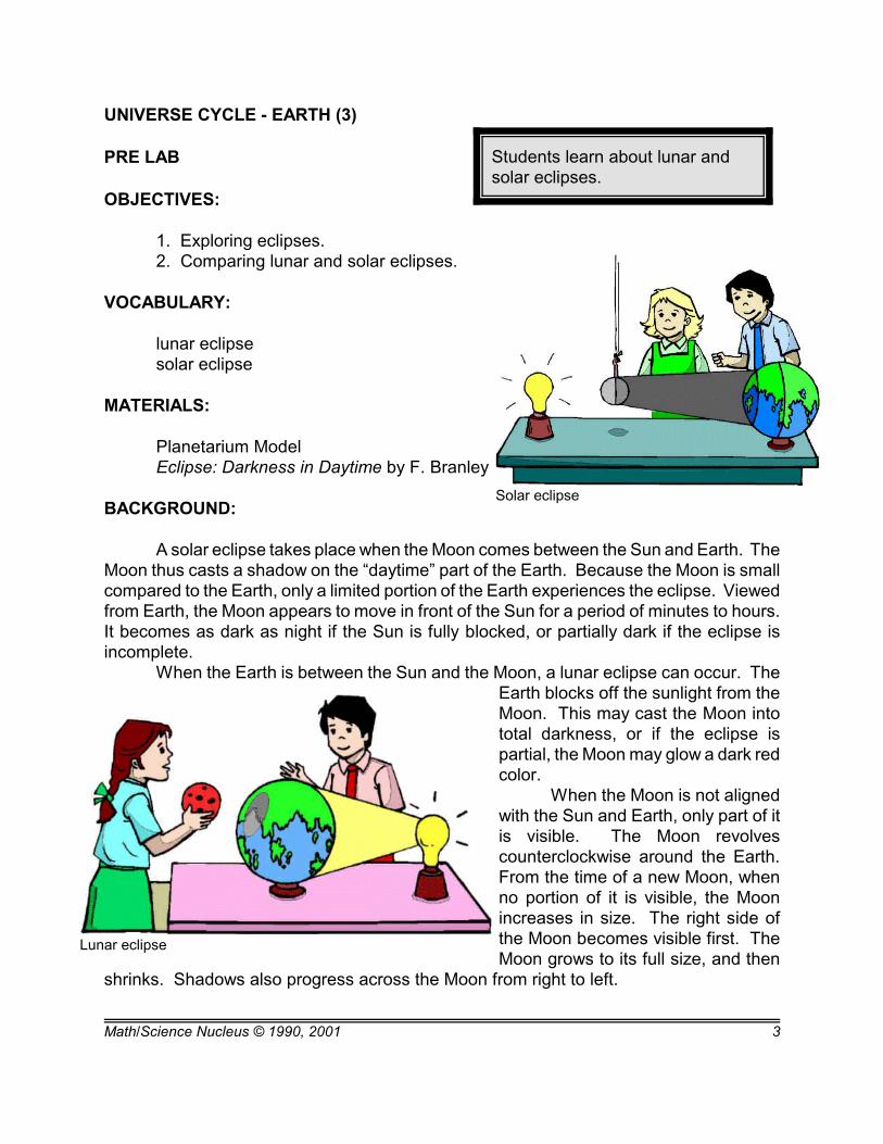
Students learn about lunar andsolar eclipses.
UNIVERSE CYCLE - EARTH (3)
PRE LAB
OBJECTIVES:
1. Exploring eclipses.2. Comparing lunar and solar eclipses.
VOCABULARY:
lunar eclipsesolar eclipse
MATERIALS:
Planetarium ModelEclipse: Darkness in Daytime by F. Branley
BACKGROUND:
A solar eclipse takes place when the Moon comes between the Sun and Earth. TheMoon thus casts a shadow on the “daytime” part of the Earth. Because the Moon is smallcompared to the Earth, only a limited portion of the Earth experiences the eclipse. Viewedfrom Earth, the Moon appears to move in front of the Sun for a period of minutes to hours.It becomes as dark as night if the Sun is fully blocked, or partially dark if the eclipse isincomplete.
When the Earth is between the Sun and the Moon, a lunar eclipse can occur. TheEarth blocks off the sunlight from theMoon. This may cast the Moon intototal darkness, or if the eclipse ispartial, the Moon may glow a dark redcolor.
When the Moon is not alignedwith the Sun and Earth, only part of itis visible. The Moon revolvescounterclockwise around the Earth.From the time of a new Moon, whenno portion of it is visible, the Moonincreases in size. The right side ofthe Moon becomes visible first. TheMoon grows to its full size, and then
shrinks. Shadows also progress across the Moon from right to left.

Math/Science Nucleus © 1990, 2001 4
PROCEDURE:
1. The book, Eclipse: Darkness in Daytime describes how scientists predict whenan eclipse will take place and where the Moon's shadow will fall. Read Eclipse: Darknessin Daytime to the class. Make sure the students understand what an eclipse is. Explainhow the appearance of the Moon changes as it rotates around the Earth. It may help todraw diagrams on the board.
2. Set up the planetarium as shown in the diagrams below. Ask the students thequestions that follow, and have them answer them out loud. The answers are given belowin parentheses.
General questions: (1) Ask the students how many planets are shown on the model. (2) Have the students name them. (Venus, Earth) (3) Which inner planets are missing?(Mercury and Mars). (4) Which planet on this model receives the most heat from theSun? (5) (Venus is the closest on this model.)Diagram A: Are there any areas of the Earth and Moon that are not receiving sunlight?What is it called when this happens? (Yes, part of the Earth is in shadow. This is calleda solar eclipse). Diagram B: Are there any areas of the Earth and Moon that are not receiving anysunlight? What is it called when this happens? (Yes, this time part of the Moon isin shadow. This is called a lunar eclipse).Diagram C: How much of the Moon is visible from Earth? (Half) Make sure the studentssee that the right half of the Moon is visible. Diagram D: How much of the Moon is visible from Earth? Is it the same part of the Moonas in the last question? (Half of the Moon is visible again. No, the left half of the Mooncan be seen this time.)
3. For more information on past and future eclipses, visit :http://sunearth.gsfc.nasa.gov/eclipse/OH/OH2002.html.
This is a NASA website with links to solar and lunar eclipse information, includingmaps, up to 3 years into the future.
Math/Science Nucleus © 1990, 2001 5
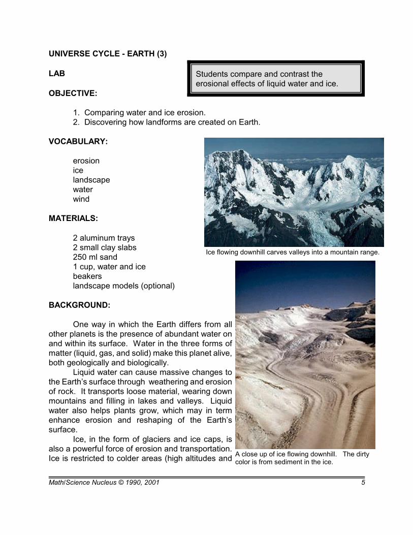
Students compare and contrast theerosional effects of liquid water and ice.
Ice flowing downhill carves valleys into a mountain range.
A close up of ice flowing downhill. The dirtycolor is from sediment in the ice.
UNIVERSE CYCLE - EARTH (3)
LAB
OBJECTIVE:
1. Comparing water and ice erosion.2. Discovering how landforms are created on Earth.
VOCABULARY:
erosionicelandscapewaterwind
MATERIALS:
2 aluminum trays2 small clay slabs 250 ml sand 1 cup, water and ice beakerslandscape models (optional)
BACKGROUND:
One way in which the Earth differs from allother planets is the presence of abundant water onand within its surface. Water in the three forms ofmatter (liquid, gas, and solid) make this planet alive,both geologically and biologically.
Liquid water can cause massive changes tothe Earth’s surface through weathering and erosionof rock. It transports loose material, wearing downmountains and filling in lakes and valleys. Liquidwater also helps plants grow, which may in termenhance erosion and reshaping of the Earth’ssurface.
Ice, in the form of glaciers and ice caps, isalso a powerful force of erosion and transportation.Ice is restricted to colder areas (high altitudes and
Math/Science Nucleus © 1990, 2001 6
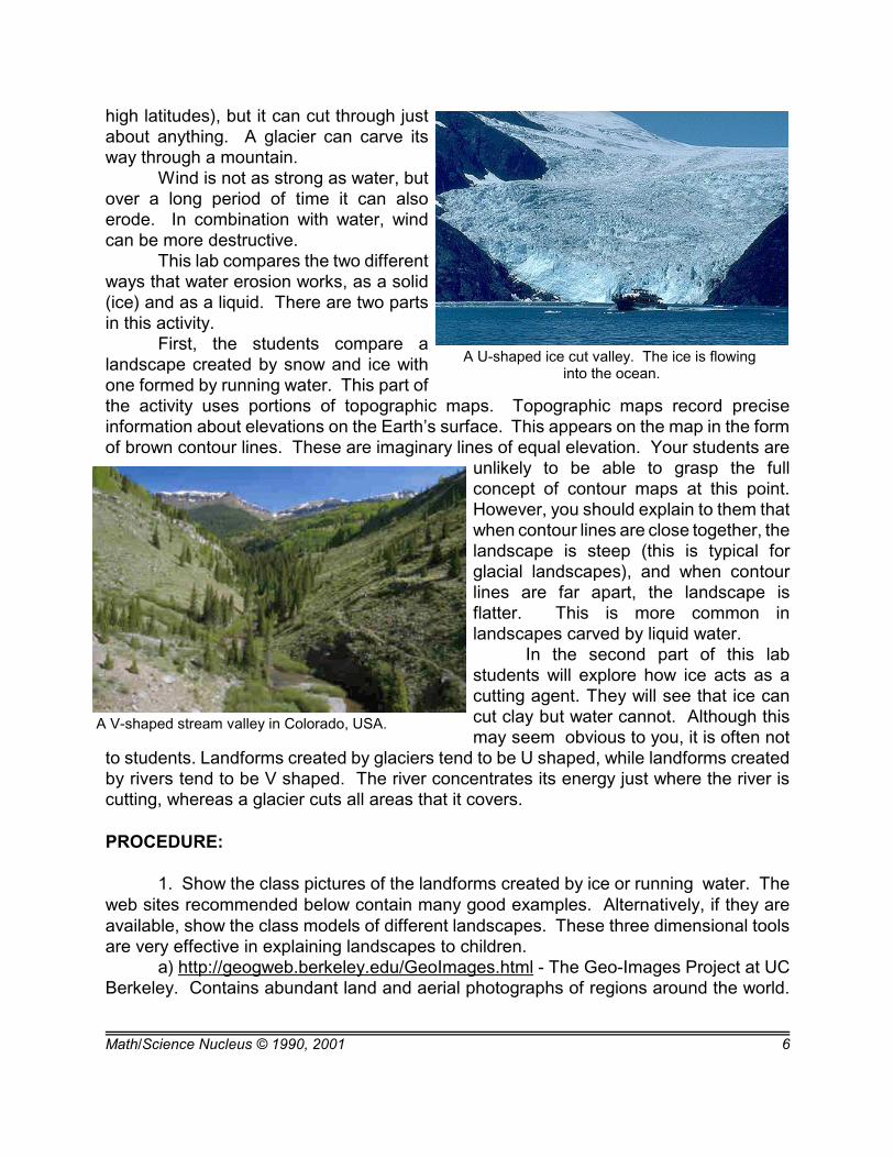
A U-shaped ice cut valley. The ice is flowing into the ocean.
A V-shaped stream valley in Colorado, USA.
high latitudes), but it can cut through justabout anything. A glacier can carve itsway through a mountain.
Wind is not as strong as water, butover a long period of time it can alsoerode. In combination with water, windcan be more destructive.
This lab compares the two differentways that water erosion works, as a solid(ice) and as a liquid. There are two partsin this activity.
First, the students compare alandscape created by snow and ice withone formed by running water. This part ofthe activity uses portions of topographic maps. Topographic maps record preciseinformation about elevations on the Earth’s surface. This appears on the map in the formof brown contour lines. These are imaginary lines of equal elevation. Your students are
unlikely to be able to grasp the fullconcept of contour maps at this point.However, you should explain to them thatwhen contour lines are close together, thelandscape is steep (this is typical forglacial landscapes), and when contourlines are far apart, the landscape isflatter. This is more common inlandscapes carved by liquid water.
In the second part of this labstudents will explore how ice acts as acutting agent. They will see that ice cancut clay but water cannot. Although thismay seem obvious to you, it is often not
to students. Landforms created by glaciers tend to be U shaped, while landforms createdby rivers tend to be V shaped. The river concentrates its energy just where the river iscutting, whereas a glacier cuts all areas that it covers.
PROCEDURE:
1. Show the class pictures of the landforms created by ice or running water. Theweb sites recommended below contain many good examples. Alternatively, if they areavailable, show the class models of different landscapes. These three dimensional toolsare very effective in explaining landscapes to children.
a) http://geogweb.berkeley.edu/GeoImages.html - The Geo-Images Project at UCBerkeley. Contains abundant land and aerial photographs of regions around the world.
Math/Science Nucleus © 1990, 2001 7
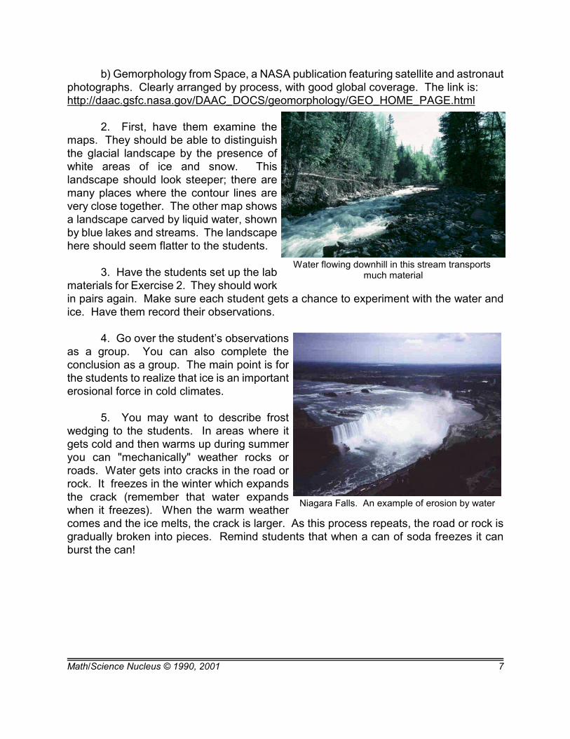
Water flowing downhill in this stream transports much material
Niagara Falls. An example of erosion by water
b) Gemorphology from Space, a NASA publication featuring satellite and astronautphotographs. Clearly arranged by process, with good global coverage. The link is: http://daac.gsfc.nasa.gov/DAAC_DOCS/geomorphology/GEO_HOME_PAGE.html
2. First, have them examine themaps. They should be able to distinguishthe glacial landscape by the presence ofwhite areas of ice and snow. Thislandscape should look steeper; there aremany places where the contour lines arevery close together. The other map showsa landscape carved by liquid water, shownby blue lakes and streams. The landscapehere should seem flatter to the students.
3. Have the students set up the labmaterials for Exercise 2. They should workin pairs again. Make sure each student gets a chance to experiment with the water andice. Have them record their observations.
4. Go over the student’s observationsas a group. You can also complete theconclusion as a group. The main point is forthe students to realize that ice is an importanterosional force in cold climates.
5. You may want to describe frostwedging to the students. In areas where itgets cold and then warms up during summeryou can "mechanically" weather rocks orroads. Water gets into cracks in the road orrock. It freezes in the winter which expandsthe crack (remember that water expandswhen it freezes). When the warm weathercomes and the ice melts, the crack is larger. As this process repeats, the road or rock isgradually broken into pieces. Remind students that when a can of soda freezes it canburst the can!

Math/Science Nucleus © 1990, 2001 8
UNVERSE CYCLE - EARTH (3) LAB
PROBLEM: How does nature change the Earth's surface over time in areas where it isextremely cold?PREDICTION: _________________________________________________________PROCEDURE:EXERCISE 1. Look at the maps on the next two pages. Compare their landscapes.1. Write the name of the location of each map.
2. Which map has more snow and ice? _________________ How can you tell? _____________________________________________________________________3. Which map has more lakes and ponds?______________________________________How can you tell? _________________________________________________________4. Which area has been more effected by ice and snow? Explain your answer. _____________________________________________________________________EXERCISE 2.MATERIALS: 2 trays, sand, 2 small clay slabs, beaker, water and ice cubes1. Place one slab of clay into a tray. Try to "carve" a landscape in one of the slabs of clayby pouring about 100 ml of water on it. Is there any way that you can make the water "cut" the clay? Explain your answer._____________________________________________________________________2. Remove the clay from the tray. Take 250 ml of sand and pour it into the tray, makinga hill. Pour 100 ml of water on the top of the sand hill. Record what happens.__________________________________________________________________________________________________________________________________________3. Now put the second slab of clay into a tray. Using a piece of ice, try to "carve" alandscape in it. Does the ice cut the clay? Can you actually make a landscape? _____________________________________________________________________4. Draw your top and side views of your ice-carved landscape on the next page.
TOP VIEW SIDE VIEW
CONCLUSION: Is water or ice the main agent of erosion in areas where it is extremelycold? What do you think is the major agent of erosion in warm areas?_____________________________________________________________________

Math/Science Nucleus © 1990, 2001 9
Map 1: Denali National Park, Alaska
UNIVERSE CYCLE - EARTH (3) LAB

Math/Science Nucleus © 1990, 2001 10
Map 2: Yosemite National Park,California
UNIVERSE CYCLE - EARTH (3) LAB

Math/Science Nucleus © 1990, 2001 11
Students read aloud to determinewhy the Earth has seasons.
UNIVERSE CYCLE - EARTH (3)
POST LAB
OBJECTIVES:
1. Exploring the reason for seasons. 2. Discovering seasons.
VOCABULARY:
fallseasonspringsummerwinter
MATERIALS:
Sunshine Makes the Seasons F. Branley
BACKGROUND:
In the Solar System, the Earth is a unique planet. Its surface has abundant liquidwater, and supports a great diversity of life. Another factor that makes the Earth specialis that its seasons allow for cold to hot climates which make living here just right forhumans.
Seasons are caused by the tilt of the Earth's axis which allows the Sun's rays towarm to cool the planet depending on the angle of the Sun’s rays.
Many people logically conclude that since we are warm in summer we are closerto the Sun., but this is false. The seasons are caused by the positioning of the Earth asit revolves around the Sun, and by the tilt of the Earth’s axis. The Earth’s axis is tilted23.5o from the vertical. This means that solar energy strikes the Earth’s surface unevenly.
It is summer in the NorthernHemisphere when the North Poletilts toward the Sun. This puts theSun more overhead, so solar energystrikes the Earth most directly. Simultaneously, the SouthernHemisphere is experiencing winter,because the Sun’s rays are leastdirectly overhead. In half of arevolution (6 months), the North Pole

Math/Science Nucleus © 1990, 2001 12
tilts away from the Sun, making solar energy least direct, so it is winter in the NorthernHemisphere, and summer in the Southern Hemisphere. Fall and spring occur in betweenthese two extremes when the axis is tilted neither toward or away from the Sun.
PROCEDURE:
1. Have the students read Sunshine Makes the Seasons out loud.
2. Ask the students if they think the book is informative about the seasons. Askthem to comment on the pictures and the writing style. Ask them each to find one goodpoint and one bad point as they critique the book.
3. Ask the students what season is occurring in Australia if the United States ishaving summer conditions (the answer is winter, because the sunlight hits Australia leastdirectly). If the students have read and understood both books, they should be able todetermine the answer.


![Spatio-Temporal Variations of Precipitation …and location of precipitation [5]. The Yangtze River (Changjiang) (Figure 1), being the longest river in China and the third longest](https://static.documents.pub/doc/80x56/5fe1237f457901682c25915a/spatio-temporal-variations-of-precipitation-and-location-of-precipitation-5-the.jpg)