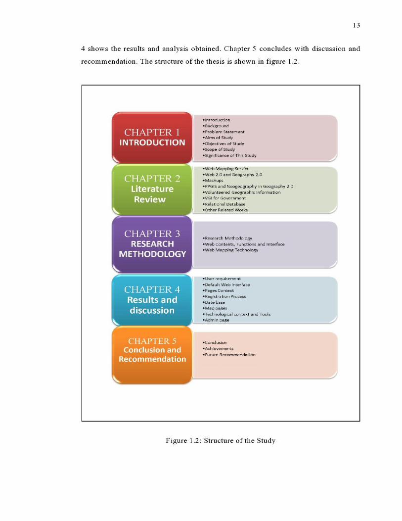
34


This d issertat ion is dedicated to m y family fo r the ir end les s support and
encouragement.
II

III
A CKNOWL EDGEMENT
Firs t a nd fo remost , I wou ld like to express hea rtfelt gratitude to m y
superv isor ASSO C . PR O F. MOHD SA FIE M O H D for hi s con stant support d urin g
m y stud y at U TM . He inspired me greatly to w ork in this project. His w ill ingness to
motivat e me contributed tremendous ly to our project . I have learn ed a lot from h im
and I am fortu nate to ha ve h im as m y mentor and supervisor
Besides , I w o ul d like to thank the authority ofU niv ers it i Tekno logi Mala ys ia
(UTM ) for providing me w ith a go od envi ronment and faci lities such as computer
la bo ra to ry to com p lete th is project w ith data and softw are w hich I need during
process.
Last but not leas t , [ wish to express m y s inc ere apprec iatio n to m y dear
friend , Mr, Mojtab a G h a naa tPis h eh, for encouragement, ass istance and friendship.
W ith out h is cont inued assi st ance and in te re st , this project w ou ld no t have been the
sa me as presented here .
IV
ABSTRACT
In recen t years new in te ract ive web s erv ices are dramati cally a lte ri ng th e way
in w hich o rdinary c itizens can create digita l spatia l data and m aps. individua lly and
collect ive ly , to produce new form s of d igita l spatia l data th at som e term "vo lunteered
geograph ic inform at ion ' (VGI). Furthermore d ue to recent convergence of grea te r
access to Internet connections . th e availa b il ity o f Global Positioning Sys tem s (GPS)
at afforda ble pr ices, and more participat ive fo rm s of inte rac t ion o n th e W eb (Web
2 .0) vast num bers of in d ivid ua ls are able to create and share geograph ic in formation .
D ue to this reason s m an y govern ments are cons idering how th ey can better engage
w ith and accept cit izen in put o nl ine, pa rt icu la r ly through th e gathering and use of
V G L T here are var ie ty types of supp lem en tary dat a that govern ment s can collect by
VGI sys tem s . One of these types is digita l photo (that cap tu red by G eo tagging).
Geotagging is the process of adding geospat ia l data to d ifferent fo rm s of m edia . This
involves enriching va rious m edi a (such as tex ts , photos or video) with locati on dat a;
latitude, lon g itude, an d a lti tude . P hotos can prov e volun teered report a nd give m ore
use ful info rmat ion of problem s to go vernment s , so can be v ery use ful fo r
government. This s tudy attempt to dev elo p a process for vo lunteered report ing of
urban road problems to local govern ments based on VGI System . Therefore, attem pt
to design a nd dev elo p a G eow eb by usi ng Google Map Apjs and rel ate d tool s and
fun ctions for running the process o f vo lun teered reporting a nd Geotaggmg dat a to
reports . Moreov er, attem pt to deve lop a database fo r s tore da ta by codi ng and
connect ing to brow ser-s ide . Finally te st the process by im po rting some su ppos it io n
reports an d . This s tudy cou ld be ex te nd ing database and adding Placemarks o n th e
streamed B aseM ap from Google for c itizens to add and Geotag inform ati on .

v
ABSTRAK
Perkh idmatan larn an sesawang interak t if yang ak uf sejak kebelakangan ill I
m embetika n pelua ng ya ng baik kepada m asyarakat mereka peta dan data spatia l
d igi tal . untuk m en gh asi lkan data reruang d igital ya ng dikena li V G L Perkembangan
ya ng m emberangs an gkan da lam du nia lnternet da n kehadira n GPS pa da harga ya ng
berpatu tan d i pasaran, se la in kew ujudan laman-laman inte rak tif te lah membantu
m en am bahkan bilanga n m asyarak at yang berkeupayaan m ereka da n berk on gs i
m aklumat geogra fi . Mengam bi l k ira perkem bangan ini . sem akin banyak insti tusi
kerajaan m empertimba ngkan pen ggun aan 1am an intera kt if dalam m endapat ka n input
daripada rnasya ra ka t te ru tamanya den gan penggunaan VGI. P elbagai bentuk data dan
m aklumat boleh dipero leh i o leh pi hak kerajaa n den gan pe ngguna an VG l. dan satu
darinya ada lah foto digi ta l yang dip erol ehi secara Geota gging. G eotagging
m erupak an sa tu proses m emasu kk an dat a geo spa tia l ke dalam pelbagai be nt uk
m edi a . In i d ilakukan denga n m elen gk apkan media-m edia te rsebut (sepert i tek s , fo to
atau v ideo) den gan m ak lumat keduduka n; lati tud, lon gitud, dan alt itud. Fo to
m erupak an bukri ya ng pal ing baik dan m aklumat paling berguna ya ng m embantu
pih ak keraj aan m en ye les aikan m asal ah-m asa lah yang dihadapi. Kaj ia n rm
m en gh asilkan prosedur pelaporan secara sukarela untuk isu-isu berkairan j alan
ban dar yang d iuru skan o leh pihak berk uasa tempa tan berda sarkan s istem V GL
Se te rusn ya , menghasi lkan G eoweb m en ggunakan Google Map A P Is dan fun gs i
fun gsi berkait an dalam m elaksan ak an pelaporan secara sukarela dan G eotagging.
K ajian in i j uga akan m embina pan gk ala n data bagi peny impanan makl umat dan
dihubungkan ke brow ser-side . B eberapa pe rc ubaan dilakukan bagi m en guj r
keberkesa na n si s tem VGI yang dihasilka n. Kaj ia n lanj ut boleh d ilakukan bagi
m emperkem as dan m emberi peluan g kep ada m asyarakat untu k melengkapkan
m aklumat pelaporan , antara nya den gan m en ambah bai k pan gkalan dat a dan
m embolehkan m asyarakat m em asukk an Placemarks .