21

Tim Homan
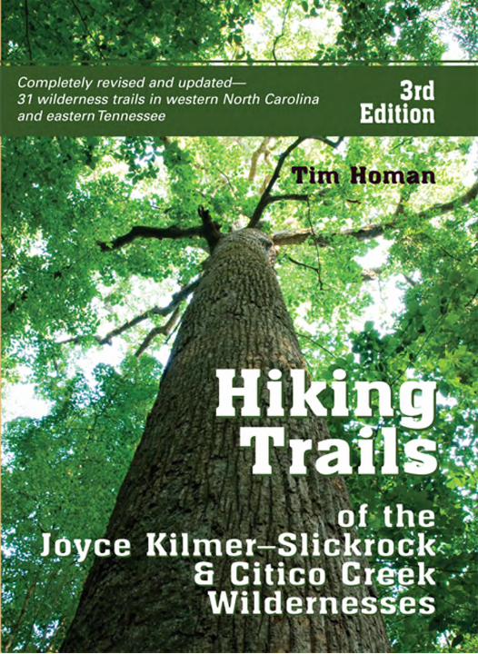
Completely revised and updated:31 wilderness trails
in western North Carolina and eastern Tennessee
Third Edition
Hikingof the
HikingTrailsTrails
of theJJoyce Kilmer–SlickrockJJoyce Kilmer–Slickrock
& Citico Creek& Citico CreekWildernessesWildernesses

Published by
PEACHTREE PUBLISHERS, LTD.1700 Chattahoochee AvenueAtlanta, Georgia 30318-2112www.peachtree-online.com
Text ©1990, 1998, 2007 by Tim HomanCover photographs ©2007 by Josh LeventhalPhotographs ©1998, 2007 by David Acton Brown, Pete Schrantz, William Houghton, Page Luttrell
Interior illustrations by Vicky HolifieldBook design by Loraine M. JoynerBook composition by Robin Sherman
Maps by XNR Productions, Middleton, WI
All rights reserved. No part of this publication may be reproduced, stored in a retrieval system, or transmitted in any form or by any means—electronic, mechanical, photocopy, recording, or any other—except for brief quotations in printed reviews, without the prior permission of the publisher.
Printed in the United States of America10 9 8 7 6 5 4 3 2 1 Third Edition
Library of Congress Cataloging-in-Publication DataHoman, Tim.
Hiking Trails of Joyce Kilmer–Slickrock and Citico Creek Wildernesses / Tim Homan. — 3rd ed.p. cm.
Includes bibliographical references and index.ISBN 13: 978-1-56145-415-0 / ISBN 10: 1-56145-415-X (alk. paper)1. Hiking—Tennessee—Citico Creek Wilderness—Guidebooks. 2. Hiking—Joyce Kilmer–Slick-
rock Wilderness (N.C. and Tenn.)—Guidebooks. 3. Citico Creek Wilderness—Guidebooks.4. Joyce Kilmer–Slickrock Wilderness (N.C. and Tenn.)—Guidebooks.I. Title.
GV199.42.T22C585 2007917.56’97—dc22
2007009461
Cover photos: Big Poplar, Chipmunk’s View (front) and Mountain View (back) by Josh LeventhalPhoto credits: pages 35 and 173 by David Acton Brown; pages 57 and 199 by Peter Schrantz; page 131 by William Houghton; page 83 by Page Luttrell

Contents
Acknowledgments iiiPreface viiiThe Combined Wilderness 1
Citico Creek History . . . . . . . . . . . . . . . . . . . . . . . . . . . . . . . . . . . 1Slickrock Creek History. . . . . . . . . . . . . . . . . . . . . . . . . . . . . . . . . 3Little Santeetlah Creek History. . . . . . . . . . . . . . . . . . . . . . . . . . . 6Wild Boar . . . . . . . . . . . . . . . . . . . . . . . . . . . . . . . . . . . . . . . . . . . . 9The Skyway. . . . . . . . . . . . . . . . . . . . . . . . . . . . . . . . . . . . . . . . . . 11The Hemlock Woolly Adelgid. . . . . . . . . . . . . . . . . . . . . . . . . . . 13The Benton MacKaye Trail . . . . . . . . . . . . . . . . . . . . . . . . . . . . . 17
Things to Know Before You Go 19Signs and Blazes . . . . . . . . . . . . . . . . . . . . . . . . . . . . . . . . . . . . . . 19Stream Crossings . . . . . . . . . . . . . . . . . . . . . . . . . . . . . . . . . . . . . 20Trail Maintenance . . . . . . . . . . . . . . . . . . . . . . . . . . . . . . . . . . . . 20Camping Areas . . . . . . . . . . . . . . . . . . . . . . . . . . . . . . . . . . . . . . . 21Hunting Seasons . . . . . . . . . . . . . . . . . . . . . . . . . . . . . . . . . . . . . 22Weather . . . . . . . . . . . . . . . . . . . . . . . . . . . . . . . . . . . . . . . . . . . . . 23
How To Use This Guide 25Trail Descriptions. . . . . . . . . . . . . . . . . . . . . . . . . . . . . . . . . . . . . 25Trail Ratings . . . . . . . . . . . . . . . . . . . . . . . . . . . . . . . . . . . . . . . . . 25
Regional Directions and Maps 28

vi n Contents
Part I—JJoyce Kilmer–Slickrock Wilderness
Slickrock Creek Trailhead 35Slickrock Creek Trailhead Directions and Map 36Slickrock Creek Trail . . . . . . . . . . . . . . . . . . . . . . . . . . . . . . . . . . 38Ike Branch–Benton MacKaye Trail. . . . . . . . . . . . . . . . . . . . . . . 46Yellowhammer Gap Trail. . . . . . . . . . . . . . . . . . . . . . . . . . . . . . . 51
Big Fat Gap Trailhead 57Big Fat Gap Trailhead Directions and Map 58Hangover Lead North Trail . . . . . . . . . . . . . . . . . . . . . . . . . . . . . 60Hangover Lead South Trail . . . . . . . . . . . . . . . . . . . . . . . . . . . . . 64Big Fat Trail . . . . . . . . . . . . . . . . . . . . . . . . . . . . . . . . . . . . . . . . . 69Windy Gap Trail. . . . . . . . . . . . . . . . . . . . . . . . . . . . . . . . . . . . . . 73Nichols Cove Trail . . . . . . . . . . . . . . . . . . . . . . . . . . . . . . . . . . . . 76
Joyce Kilmer Forest Trailheads 83Joyce Kilmer Forest Trailheads Directions and Map 84Deep Creek Trail . . . . . . . . . . . . . . . . . . . . . . . . . . . . . . . . . . . . . 86Haoe Lead Trail . . . . . . . . . . . . . . . . . . . . . . . . . . . . . . . . . . . . . . 92Jenkins Meadow Trail . . . . . . . . . . . . . . . . . . . . . . . . . . . . . . . . . 99Joyce Kilmer National Recreation Trail . . . . . . . . . . . . . . . . . . 104Naked Ground Trail. . . . . . . . . . . . . . . . . . . . . . . . . . . . . . . . . . 110Stratton Bald Trail . . . . . . . . . . . . . . . . . . . . . . . . . . . . . . . . . . . 117Wolf Laurel Trail . . . . . . . . . . . . . . . . . . . . . . . . . . . . . . . . . . . . 125
n

Contents n vii
Part II—Citico Creek Wilderness
Sassafras Ridge Trailheads 131Sassafras Ridge Trailheads Directions and Map 132Fodderstack–Benton MacKaye Trail . . . . . . . . . . . . . . . . . . . . 134Stratton Bald Alternate . . . . . . . . . . . . . . . . . . . . . . . . . . . . . . . 141Cold Spring Gap Trail . . . . . . . . . . . . . . . . . . . . . . . . . . . . . . . . 145Falls Branch Trail . . . . . . . . . . . . . . . . . . . . . . . . . . . . . . . . . . . . 150Jeffrey Hell Trail . . . . . . . . . . . . . . . . . . . . . . . . . . . . . . . . . . . . . 154Grassy Branch Trail . . . . . . . . . . . . . . . . . . . . . . . . . . . . . . . . . . 159Flats Mountain Trail . . . . . . . . . . . . . . . . . . . . . . . . . . . . . . . . . 164
Citico Creek Trailheads 173Citico Creek Trailheads Directions and Map 174South Fork Citico Trail . . . . . . . . . . . . . . . . . . . . . . . . . . . . . . . 176North Fork Citico Trail . . . . . . . . . . . . . . . . . . . . . . . . . . . . . . . 182Brush Mountain Trail . . . . . . . . . . . . . . . . . . . . . . . . . . . . . . . . 189Pine Ridge Trail . . . . . . . . . . . . . . . . . . . . . . . . . . . . . . . . . . . . . 194
Doublecamp Creek Trailheads 199Doublecamp Creek Trailheads Directions and Map 200Rocky Flats Trail. . . . . . . . . . . . . . . . . . . . . . . . . . . . . . . . . . . . . 202Mill Branch Trail . . . . . . . . . . . . . . . . . . . . . . . . . . . . . . . . . . . . 207Crowder Branch Trail . . . . . . . . . . . . . . . . . . . . . . . . . . . . . . . . 211Big Stack Gap Branch Trail . . . . . . . . . . . . . . . . . . . . . . . . . . . . 215Stiffknee–Benton MacKaye Trail . . . . . . . . . . . . . . . . . . . . . . . 220
The Idea of Wilderness 227The Wilderness Act . . . . . . . . . . . . . . . . . . . . . . . . . . . . . . . . . . 229
Environmental and Courtesy Guidelines 231Before the Hike. . . . . . . . . . . . . . . . . . . . . . . . . . . . . . . . . . . . . . 231On the Trail . . . . . . . . . . . . . . . . . . . . . . . . . . . . . . . . . . . . . . . . 231No-Trace Camping . . . . . . . . . . . . . . . . . . . . . . . . . . . . . . . . . . 232Backcountry Courtesy. . . . . . . . . . . . . . . . . . . . . . . . . . . . . . . . 233
Tips for Beginning Hikers 235Adopt-a-Trail 238Addresses and Maps 240Index of Nature Illustrations 241Hiking Guides by Tim Homan 243
Preface
The Third EditionDuring the spring, summer, and early autumn of 2006, I hiked all
of the trails included in this guide except for Brush Mountain, whichhad not been maintained in some years and was being considered forpossible decommissioning by the Forest Service. (Brush Mountainwas not decommissioned, but it still needs a maintenance makeover.)As in 1988, when I last hiked every trail in the combined wilderness, Ipushed a big orange, incessantly clicking, spoked wheel device thatresembles a unicycle. By using the wheel, I was able to record dis-tances in feet, such as 69,545 feet for the Fodderstack Trail, then con-vert the large numbers to the nearest tenth. If a measurement fellexactly between tenths, 2.75 for example, the figure was rounded upto the nearest tenth.
Over the months of hiking on weekends, holidays, and vacationdays, I discovered a surprising number of changes, both large andsmall. Insect pests and floods brought change to the forests andstreams. Additions, deletions, and relocations brought change to thetrail network.
An especially deadly outbreak of pine beetles (natural home-grown insects that have long played an integral role in forest succes-sion) killed over 90 percent of the mature pitch, Virginia, and TableMountain pines in the combined wilderness. The hemlock woollyadelgid, an exotic and prolific pest, is killing the area’s remainingold-growth hemlocks with methodical swiftness. Entire groves ofthese large, small-needled conifers are already dead or doomed inthe upper Slickrock Creek basin and the Joyce Kilmer Memorial For-est. Their sudden mass death is an aesthetic and ecological loss nosugar coating can soothe.
But not all is death and destruction. The pines will come backafter the next big disturbance, probably a hot, hardwood-killing fire,and there is realistic hope that the hemlock will survive as a wide-spread species. In the interim, eastern white pine continue to invade

the uplands, bringing their tiered grace and year-round green to the forests where the other pines have recently died. Wildflowers still quilt the north-facing slopes, waterfalls still bend to gravity’sbidding as they leap white and full of froth over ledges, SlickrockCreek’s outsized pools are still an inviting green, and old-growth yel-low buckeyes still grow noticeably thicker from decade to decade.And the Southern Appalachians are still an outdoor magic show,with enough surprise and beauty to last a lifetime of looking.
Hurricane-caused floods have eroded and, in some places,washed away short sections of the old railroad grades. These ram-paging floods made footing a little more difficult, forced changes inthe number and location of fords, and required short trail reloca-tions above and away from the dangerously steep creek banks. Onthe positive side, these battering-ram floods help the streams toreclaim the land’s former contours, to gradually erase the flat, thelinear, and the manmade.
Over the years there have been numerous minor changes in thetrail system. Naked Ground Trail is now 0.2 mile longer. SlickrockCreek Trail now has twelve signed fords instead of ten unsignedfords. The Forest Service moved South Fork Citico’s trailhead out toFS 35, making the trail a little more than a tenth-mile longer, and thetrailhead much cleaner and safer. Thanks go to the Forest Service.Good job.
Hikers have changed Big Fat Trail’s second stream crossing backto its original location. Big Fat now officially ends at its junctionwith the Slickrock Creek Trail, and Nichols Cove Trail now ends atits junction with Big Fat Trail, making Nichols Cove 0.1 mileshorter. The lower-elevation end of Grassy Branch Trail has beenrerouted, eliminating one Eagle Branch crossing and making theroute 0.1 mile shorter.
The old Naked Ground cutoff—the path that once by-passed thelast pull to the top of the Haoe for Haoe Lead Trail hikers headedtoward Naked Ground—is long gone. And the Forest Service will nolonger maintain the Jenkins Meadow Connector, the 0.9-mile paththat linked Naked Ground and Jenkins Meadow Trails. And so onand so forth.
The two most noteworthy changes in the trail system are therouting of the long-distance Benton MacKaye Trail through the
Preface n ix
combined wilderness and the relocation and further lengthening ofthe Fodderstack Trail, which the Benton MacKaye follows. At ColdSpring Gap, where Fodderstack once rose with the ridgeline to thenortheast toward Stratton Bald, it now winds to the north throughthe Citico Creek Wilderness on Cold Spring Gap Trail’s formertreadway. After forking away from Cold Spring Gap Trail, Fodder-stack follows a 1.2-mile stretch of treadway to the northeast, where itties back into the old Fodderstack route 0.3 mile south of Cherry LogGap. The Benton MacKaye Trail Association built this 1.2-mile seg-ment in 2004.
Fodderstack’s relocation made it easier to hike and 0.6 milelonger, and it made Cold Spring Gap Trail 1.3 miles shorter. It also leftthe former Fodderstack section from Cold Spring Gap to 0.3 milesouth of Cherry Log Gap nameless and numberless. This 1.9-miletrail segment has been christened the Stratton Bald Alternate, trail54A. All this moving and renaming means that the Stratton BaldTrail’s upper-elevation end connects with the Stratton Bald Alter-nate, not Fodderstack as always before. It also means the Alternate isfoot travel only; legal horse traffic has been rerouted away from thesometimes steep portion of trail up to and over Stratton Bald’s west-ern shoulder.
Over the last twenty to twenty-five years nature has made herown addition, a welcome wildness to the mile-high mountains ofthe wilderness. In 1988, when I camped in or beside the designatedwilderness for four or five days at a stretch, I never heard the firstnote of coyote music. This go-around, their chorused yipping wokeme on three different occasions. On my last backpack trip in thewilderness, the newcomers animated midnight with a ringing songjust up the ridgeline from my tent.
As always, enjoy the mountains.
x n Preface

We do not go to the green woods and crystal waters to rough it, we go to smooth it. We get it rough enough at home; in towns and cities; in shops, offices, stores,banks—anywhere that we may be placed—with the necessity of being on time and up to our work; ofproviding for the dependent ones; of keeping up,catching up, or getting left.
“Nessmuk”Woodcraft and Camping

Slickrock CreekIke Branch–Benton MacKayeYellowhammer Gap
Wildcat Falls
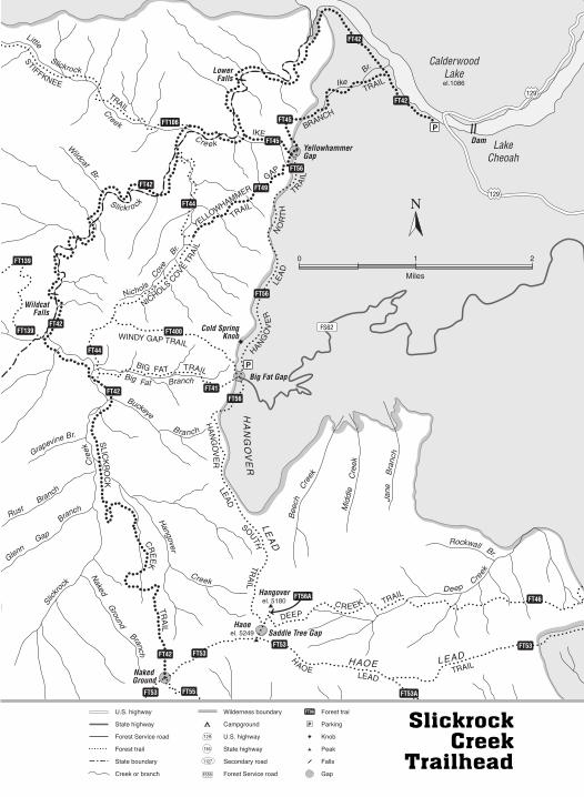
Slickrock Creek Trailhead
Trails
Slickrock Creek Trailhead Directions and Map
THE SLICKROCK CREEK TRAILHEAD is on the west side of US 129 atthe southern end of the bridge over Calderwood Lake, which is theboundary between North Carolina’s Graham and Swain Counties.Signs for the Little Tennessee River and the two bordering counties(the welcome to/leaving kind) mark both ends of the bridge. Thesouth side of the bridge (the trailhead side) is further distinguishedby a fancy Graham County sign.
Approach from the south. Take US 129 North slightly over14.0 miles beyond where NC 143 West turns left toward Joyce Kil-mer Memorial Forest. This three-way intersection is approximately1.0 mile north of Robbinsville, North Carolina. As you near thetrailhead, US 129 parallels the Cheoah River (Cheoah means otterin Cherokee), passes the signed turn for Big Fat Gap, then finallycrosses the Cheoah River at the community of Tapoco (name de-rived from Tallassee Power Company). After crossing the Cheoah,continue approximately 0.4 mile to the single-track road (pavedentrance) to the left of the highway immediately before it crossesthe bridge over Calderwood Lake. That road is the beginning of thetrail. There is pull-off and pull-in parking along and slightly infrom the highway at the trailhead.
Approach from the north. From the US 129–Foothills Parkwayjunction in Tennessee, travel US 129 South (the bridge is 2.1 milesbeyond the Highway 129– Highway 28 junction) across the bridgeover Calderwood Lake, then immediately turn off the highway to theright.
Approach from the southwest. If you are already near the JoyceKilmer Memorial Forest, or if you are traveling from the south-west—from Tennessee on the Cherohala Skyway—take the shortcutthrough Horse Cove Campground. Once you reach US 129, turn leftand proceed northward approximately 7.5 miles to the trailhead tothe left immediately before the bridge. (See page 32 for the shortcutdirections from Joyce Kilmer Memorial Forest to US 129.)
36 n
0 1 2
129
129
FS62
WildcatFalls
LowerFalls
Dam
Cold SpringKnob
Miles
Hangoverel. 5180
Haoeel. 5249
EENKFFITS
LIART
KC
OR
KCI
LS
KE
ERC
LIA
RT
RE
VO
GN
AH
DAEL
HTUOS
LIA
RT
BIG FAT TRAIL
LIARTPAGYDNIW
LIA
RTEVOC
SLOHCIN
RE
VO
GNAH
DA
ELH
TR
ON
LIA
RTREMMAHWOLLEY
PAG
EKI
HCNARB
LIART
EOA
H
DAELLIART
PEED
KEERCLIART
SNIKNEJ
LIART
Slickrock
Little
Creek
Br.
Naked
Ground
Branch
Slick
rock
Cre
ek
Hangover
Creek
GlennGap
BranchRust
Branch
Grapevine Br.
Buckeye
Branch
Big Fat Branch
W
ildcatBr.
Creek
Slickrock
Nichols
Cove
Br.
IkeBr.
Bee
chC
reek
Mid
dle
Cre
ek
Jane
Bra
nch
Rockwall Br.
DeepCre
ek
Horsecove
Adamca
mp
CalderwoodLakeel.1086
LakeCheoah
TEN
NESSEE
HA
NG
OV
ER
LE
AD
HAOE LEAD
FT56
FT56
FT56
FT41
FT44
FT44
FT42
FT42
FT42
FT49
FT45
FT42
FT42
FT45
FT55
FT53FT53 FT53
FT46
FT42
FT53
FT139
FT106
FT139 FT400
FT53A
Big Fat Gap
YellowhammerGap
Saddle Tree Gap
Naked Ground
P
P
P
P
P
P P
P
P
P
P
P
P
P
P
FT56A
U.S. highway
State highway
Forest Service road
Forest trail
State boundary
Creek or branch
129
FS59
Wilderness boundary
Campground
U.S. highway
State highway
Secondary road
Forest Service road
FT98
P
Forest trail
Parking
Knob
Peak
Falls
Gap
165
1127
SlickrockCreek
Trailhead

Slickrock Creek TrailFoot Trail 42: 13.3 miles
n Trail Difficulty See trail descriptionn Start Slickrock Creek Trailhead, 1,160 feetn End Haoe Lead and Naked Ground Trails at Naked
Ground, 4,860 feetn Trail Junctions Ike Branch–Benton MacKaye (two),
Benton MacKaye (three), Stiffknee–Benton MacKaye,Nichols Cove, Big Stack Gap Branch, Big Fat, HaoeLead, Naked Ground
n Topographic Quadrangles Tapoco NC-TN,Whiteoak Flats TN-NC (small amount)
n Features Cascades and waterfalls; old-growth forest;excellent spring wildflower display
SLICKROCK CREEK IS THE LONGEST AND WETTEST (twelve fords)trail in the combined wilderness. The stream it follows and fords
is well-known for its clear water, cascades, waterfalls, swimmingholes—and people. Its popularity combined with its easy access havea predictable outcome: Slickrock Creek’s northernmost 8.0 miles,from its beginning to its Big Fat junction, is the most heavily hikedlong section of trail in this guide. On hot summer weekends thereare often large groups of swimmers in the pools below the waterfalls.In season, hunters and fishermen also tread parts of this trail.
In addition to being the longest trail in the entire wilderness,Slickrock Creek also gains more elevation—3,700 feet—than anyother footpath in this guide. Two factors make an overall difficultyrating impractical, if not laughably inaccurate. The first is that rela-tively few hikers walk the whole trail at one time. Most people traipsesegments of the path parallel to the stream north of the Big Fat junc-tion. The second is that the elevation gain is unevenly distributed.The route’s first 8.0 miles, from the trailhead to its twelfth and finalford, average a very gentle gradient of 105 feet of elevation gain per
38 n Slickrock Creek Trailhead
mile. Despite its rocky footing and occasional dips and rises, thislong section is easy to moderate walked in either direction, dayhik-ing or backpacking.
In contrast, the trail’s last 5.3 miles—from its Big Fat junction toNaked Ground—ascend 535 feet per mile. Near its end, this stretchhas a few short, rocky surges that are the steepest pitches in the com-bined wilderness. This portion of the walkway is, overall, moderateto strenuous for dayhikers and strenuous for backpackers.
Slickrock Creek, which originates outside of the wilderness,starts at the lowest elevation of any trail in this guide. This descrip-tion begins at the trailhead bulletin board, 0.1 mile down the oldroad from US 129. The opening segment follows the road to thenorthwest, parallel to the shoreline of Calderwood Lake. Rock out-crops and boulders protrude from the upslope. Growing betweenthe boulders is a diverse, second-growth forest—tall and straightand predominantly deciduous. For now at least, the over-100-foot-high white ashes and sweetgums are keeping up with the yellowpoplars.
At 0.6 mile the treadway arrives at the first of its many junctions.Ike Branch Trail angles up and to the left. Continuing straight ahead,the well-constructed sidehill trail crosses Ike Branch, then undulateseasily on the steep slope high above the lake. The rock outcrops arepart of the bluff carved by the Little Tennessee, the river that wasdammed to make the green lake below.
There are a few yellowwoods, a scarce tree of scattered and local-ized occurrence, on the downslope along this stretch. Its fragrant flow-ers, with their typical Pea-family shape, hang in white, wisterialikeclusters, occasionally over a foot long. The yellowwoods throughout agiven area bloom together, during the first half of May, at irregularintervals of two to five years.
Slickrock Creek Trail enters the wilderness in the middle of adescending horseshoe bend at mile 1.6. Once inside the boundary,the walkway swings to the south, then steadily works its way downbelow bluffs to Slickrock Creek. Here, where the treadway picks upthe old logging railroad bed at approximately 1,160 feet, is the lowesttrailside elevation within the two-state wilderness. Powerful floodshave ripped up some of the old railroad grades where they wereespecially close to the creek. The result is the beginning of a more
Slickrock Creek Trail n 39

natural contour and rough, wet, and rocky walking in places—toughgoing for the stumblefooted.
Almost as soon as it reaches stream level, the footpath rises upand away from the water before coming right back down to it. This ispart of the pattern. For the next 7.5 miles, the trail parallels windingSlickrock Creek up its basin to the south. It often leads up and awayor out and away from the stream, then returns. Despite these repeatedrovings, the route frequently remains right on the bank with scarcelya rhododendron branch between you and the rushing water.
At mile 2.8 where the wide walkway becomes pinched, andwhere the railroad once crossed over on a bridge, the track fordsSlickrock Creek (east side to west side, North Carolina to Tennessee)for the first of twelve signed times. The Cherokee word for thiswatercourse means “slick rock.” As was so often the case, early settlerssimply translated the Native American name. The Cherokee wereright; the rocks are slippery.
Three-tenths mile beyond the first ford, you arrive at a particu-larly high cascade that drops, perhaps 15 feet altogether, over twowide ledges. This cascade is labeled as Lower Falls on the topo map.While this falls is small by Southern Appalachian standards, itsplunge pool is remarkable by any standard. A slightly flattened circle,wider than long, this catch pool is one of the largest I have ever seenon a creek-sized stream. Lower Falls pool is the dark green color of agood, over-your-head-deep, goose-pimple-cold swimming hole.
The railroad grade treadway runs past fords and junctions inrapid succession above Lower Falls. The second ford is at mile 3.6.Two-tenths mile upstream from that ford, Slickrock Creek comes toits second connection with Ike Branch at a campsite and sign. Theroute fords for the third time at mile 4.0. Three-tenths mile after thisford, Stiffknee Trail ends at its usually signed junction immediatelybefore the main trail rock-steps across Little Slickrock Creek. Slightlymore than 50 yards beyond where it regains the eastern bank afterthe fourth ford, the track passes its meeting with Nichols Cove Trailat mile 4.5.
Shortly after crossing Nichols Cove Branch, the course closelyparallels the creek below occasional bluffs or rocky cut-banks. Inplaces the corduroy ripples of the old railroad ties are still evident.
40 n Slickrock Creek Trailhead

Here the walking, down and upstream from the fifth ford at mile 4.9,leads beside a series of cascades.
Since this trail is so long and there is not space enough to men-tion every shoaling run, every bedroom-sized boulder, every enticingpool, every bank-to-bank ledge, I will simply state that this fast-footed creek is the embodiment of mountain water, which is to saythat it abounds with the innately pleasing power and grace andbeauty of a crystal clear stream flowing white through gray rock. Allof this color and motion is flanked with forest and covered with skyand clouds, enhanced by the play of sun quiver and shadow on themoving mirror, and the unwavering sound of water wearing downrock. In the old days people categorized flowing water as quick andclean, clear water as sweet. This creek is quick and sweet.
The forest along Slickrock Creek was cut clean for miles up itswatershed during the South’s hell-for-leather logging days, in this casefrom 1915 to 1922. Today, the riverine and lower-slope forest is diverse, predominantly deciduous, and entirely second-growth. As youcan see, the trees have grown up, competing for the canopy, ratherthan out. Yellow poplar, white ash, sweetgum, and an occasional syca-more and white pine are already at or above 100 feet in height.
Thirty yards after crossing a small side branch at mile 5.9, thetrail bends sharply back to the right and up, bypassing a now prob-lematic goat path on the high cutbank straight ahead. Starting withthe sixth ford at mile 6.4, the route makes four fords in 0.3 mile. Atmile 7.0 you come to Wildcat Falls—a series of four high cascades,sluicing raceways, and short free falls, cutting back into a series ofstubborn ledges. The lowermost two chutes pour 20 feet into thelarger of the two dividing catch pools.
The route fords for the tenth time right after the falls, then fordsagain at mile 7.3. Big Stack Gap Branch Trail ties into Slickrock CreekTrail at a campsite and signpost immediately across the eleventh ford.
Most of the next 0.6 mile is easy walking through a floodplainforest out of sight of the stream. This is the only stretch of trail in theentire wilderness where the umbrella magnolia is conspicuouslycommon. This deciduous magnolia, distinguished from the muchmore abundant Fraser magnolia by its uneared leaf base, has thelargest simple leaves and flowers of any tree in the wilderness.
Slickrock Creek Trail n 41

Approximately 100 yards after the route returns to the rockycreekside, it reaches its twelfth and final ford at 7.9 miles and an ele-vation of approximately 2,010 feet. Once across, you will quicklyarrive at the usually signed Slickrock Creek–Big Fat junction (mile8.0). If you want to exit the wilderness by way of Big Fat Trail, turnleft (northeast) onto the end of Big Fat and walk the well-worntreadway 0.1 mile to the Big Fat–Nichols Cove connection beforeturning right and slightly uphill with Big Fat Trail.
Slickrock Creek Trail proceeds southward up the watershed onthe east side of the stream. The hiking, rising easily between dips totributaries, is usually on railroad grade and often out of good sightof the brook. At mile 8.2 the track rock-hops Buckeye Branch; 0.8mile farther it crosses Hangover Creek on a jumble of small boul-ders. As coolness and moisture increase with elevation, the trees,including several 35-foot-tall umbrella magnolias, become notice-ably thicker than along the lower creek.
The route turns sharply left, up and away from its creek, atapproximately 2,640 feet at mile 9.3. Over the years the sign that hasmarked this turn has had a few carved PG-13 phrases alluding to theclimb ahead. The second word of the most recent hiker carving was“buster.” Above the turn, where the treadway no longer parallelsSlickrock Creek, the ascent to Naked Ground begins. This final seg-ment gains 2,220 feet in 3.9 miles. If you walk slowly, this lightlytraveled section is not as bad as entering the infernal regions, as for-mer graffiti suggested. The overwhelming majority of the grades arebetween easy and moderate. The short surges—the rocky scramblesthat gain 30 to 50 feet of elevation on what seems like a 45-degreepitch—are challenging and memorable, especially during or rightafter rain.
The trail follows a logging spur to a fork of Hangover Creekbefore switchbacking up and away from the branch at mile 10.4.From here the footpath rises steadily by switchback to the crest of aspur ridge, and the first of the steep climbs. The track remains on ornear the rocky keel for a few tenths of a mile, then half-circlesthrough an impressive old-growth forest on a northwest-facingslope. At first the forest is dominated by both hemlock and Carolinasilverbell. Many of the hemlocks are 9 to 12 feet in circumferenceand well over 100 feet in height, and many of the dark-barked
42 n Slickrock Creek Trailhead

silverbells are 6 to 8 1/2 feet around and 80 feet tall. Clumps of mul-tiple-boled Fraser magnolia are common and easily recognized bytheir smooth, light-gray bark and whorls of large leaves. At mile11.3 the thickest trailside silverbell—an impressive specimen 8 feet8 inches around with particularly dark and flaky bark—stands onthe upslope just above the treadway.
The look and feel of the hemlock-silverbell forest has changeddramatically since the late 1980s. Then the understory was oftenscant and the forest floor was dark with dense hemlock shade. Nowwith many of the hemlocks already dead or dying and with the entirestand in danger of succumbing to the hemlock woolly adelgid, thenumerous light gaps have encouraged rapid understory growth.
Farther up the slope, this respite of easy walking passes besidelarge red and sugar maples, some 9 to 12 feet in circumference.Most of the upper Slickrock basin above the clear-cut was high-graded—selectively cut for valuable species. Timbering in the basincame to a halt when Calderwood Lake flooded the railroad system.Thus, as the lake neared completion, the loggers were forced tohurry, leaving the old-growth sugar maple. They did, however,manage to drag out the virgin black cherry.
The treadway winds back up to the crest and continues to climbon or near its narrow spine. Here, where the bare rock backbone ofthe steep-sided ridge frequently pokes out, and where picturesque,old-growth hemlocks and yellow birches stand in the full force of thewind, the land has that rugged look of out-West country.
The narrow, rocky path ascends a ledged pitch with root holds atmile 11.9. At mile 12.5 the walking tunnels into a heath bald (the oneplainly visible from the Hangover) composed primarily of Catawbarhododendron. Three-tenths of a mile into the tangle, the right forkleads a very short distance to an open view (over the rhododendron)of the Haoe and the rocky heath bald atop the Hangover.
The final 0.4 mile, out of the rhododendron and into northernhardwoods shading grass and ferns, angles to the west away from theridgeline. Seventy-five yards before Naked Ground, a side path bendsback to the right to a last-water spring. Slickrock Creek Trail ends atNaked Ground—a gap that is a major trail intersection and anoverused camping area. Haoe Lead passes through the gap; NakedGround Trail ends at its south side, opposite Slickrock Creek.
Slickrock Creek Trail n 43

Slickrock is the widest and deepest creek in the combinedwilderness. Its fords can become dangerous following heavy rainfallduring any season. The water level is normally highest in winter andearly spring before leaf-out. Throughout this time of the year, thelower fords often remain midthigh to crotch deep for weeks. Withnormal spring precipitation, the stream flows fairly full until leaf-outreaches the highest ridges in late May. During summer and fall,except after thunderstorms, the fords usually present no problemsfor adults, other than slipping and getting wet. Several of the upperfords may be crossed dry-shod during drought.
Nature NotesSlickrock Creek’s two most spectacular spring wildflower dis-
plays occur at opposite ends of the route—roughly 12.0 miles, 3,300feet of elevation, and two months apart. The initial area is on therocky northeast-facing slope at the beginning of the trail. Here, onthe incredibly lush hillside above Calderwood Lake, spring firstunfolds within the area covered by this book. A warm spell in latewinter may bring the hepaticas to bloom in early March. This tract,which rivals Poplar Cove in sheer numbers of ground-carpetingwildflowers, peaks in diversity from March 20 through April 10. (SeeIke Branch, the following trail, for a more detailed description.)
The second show starts when the heath bald blossoms along thenarrow ridge near the top end of the path. Although the bald is prac-tically a monoculture of the Catawba rhododendron, this particularflowering species has blooms that are big and showy and, in a goodyear, abundant. This evergreen shrub ordinarily peaks sometime inlate May or early June.
The pocket of old-growth forest starting at mile 11.2 has ahigher concentration of mature Carolina silverbell than any othertrail-traversed area in the combined wilderness. The silverbell wasone of the moist-site species that loggers routinely left when theyhigh-graded the woods above the end of the clear-cut. Thus today, atthe higher elevations in the wilderness, from the end of the old clear-cuts to the tree’s upper elevation limit at approximately 4,800 feet,burly, old-growth silverbells are common on moist slopes and ridges.
The Carolina silverbell is also known as snowdrop tree andmountain silverbell. Throughout most of its range, which is confined
44 n Slickrock Creek Trailhead
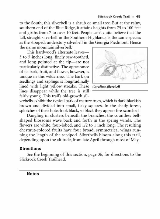
to the South, this silverbell is a shrub or small tree. But at the rainy,southern end of the Blue Ridge, it attains heights from 75 to 100 feetand girths from 7 to over 10 feet. People can’t quite believe that thetall, straight silverbell in the Southern Highlands is the same speciesas the stooped, understory silverbell in the Georgia Piedmont. Hencethe name mountain silverbell.
This hardwood’s alternate leaves—3 to 5 inches long, finely saw-toothed,and long pointed at the tip—are notparticularly distinctive. The appearanceof its bark, fruit, and flower, however, isunique in this wilderness. The bark onseedlings and saplings is longitudinallylined with light yellow streaks. Theselines disappear while the tree is stillfairly young. This trail’s old-growth sil-verbells exhibit the typical bark of mature trees, which is dark blackishbrown and divided into small, flaky squares. In the shady forest,splotches of their boles look black, so black they appear fire-scorched.
Dangling in clusters beneath the branches, the countless bell-shaped blossoms wave back and forth in the spring winds. Theflowers are white, four-lobed, and 1/2 to 1 inch long. The resultingchestnut-colored fruits have four broad, symmetrical wings run-ning the length of the seedpod. Silverbells bloom along this trail,depending upon the altitude, from late April through most of May.
DirectionsSee the beginning of this section, page 36, for directions to the
Slickrock Creek Trailhead.
Notes
Slickrock Creek Trail n 45
Carolina silverbell


![Rasinski, Homan Biggs.515.106[1]](https://static.documents.pub/doc/80x56/55cf9ceb550346d033ab87b5/rasinski-homan-biggs5151061.jpg)


