In October 2008, the Society of American Foresters will hold its convention in Reno, Nevada. Attendees can visit nearby Virginia City, the home of America’s first major “silver rush,” the Comstock Lode. Virginia City was built over one of North America’s largest silver deposits and a “forest of underground timbers.” Demand for timber was satisfied by the large forest at the upper elevations of the Sierra Nevada, especially around Lake Tahoe. After discussing historical background, this article offers a short forest history tour based on Nevada historical markers and highlighting Lake Tahoe logging history. TIMBER FOR THE COMSTOCK G old was discovered in western Nevada around 1850 by prospectors on their way to California. In early 1859, James Finney and a small group of prospectors discovered the first indications of silver ore near present-day Virginia City. Later that year other prospectors located the ledge of a major gold lode. Fellow prospector Henry Comstock claimed the ledge as being on his property and soon gained an interest in the area, and the strike became known as the Comstock Lode. Finney, nicknamed “Old Virginny” after his birthplace, reportedly named the collection of mining tents in honor of himself during a drunken celebration. As he watched precious whiskey seep from a broken bottle into the desert sand, he christened the new set- tlement “Old Virginny Town.” In time, it became Virginia City and is now one of the best-preserved mining boom towns in the West. 1 Part of its enduring fame can be attributed to the long- running television series, Bonanza, which situated the Cartwright family’s Ponderosa ranch near Virginia City. Over the next twenty years, the 2 1 / 2-mile deposit of high-grade ore would produce nearly $400 million in silver and gold, create several fortunes, and lead to Nevada’s early admission to the Union during the Civil War, even though it lacked the popula- tion required by the Constitution to become a state. 2 In 1873, a huge ore body of vast richness named the Big Bonanza was opened, and it made its four investors into tycoons. 3 Virginia City quickly became one of the most important cities between Chicago and San Francisco. But when the mines, which went into decline after 1874, closed in 1898, Virginia City just as quickly became a ghost town. BY THOMAS J. STRAKA 4 FOREST HISTORY TODAY | SPRING/FALL 2007
Transcript
In October 2008, the Society of American Foresters will hold its convention in Reno, Nevada. Attendees can visit nearby Virginia City, the home of America’s first major “silver rush,” the Comstock Lode.
Virginia City was built over one of North America’s largest silver deposits and a “forest of underground timbers.”Demand for timber was satisfied by the large forest at the upper elevations of the Sierra Nevada,
especially around Lake Tahoe. After discussing historical background, this article offers a short forest history tourbased on Nevada historical markers and highlighting Lake Tahoe logging history.
TIMBER FOR THE
COMSTOCK
Gold was discovered in western Nevada around 1850 by prospectors on theirway to California. In early 1859, James Finney and a small group ofprospectors discovered the first indications of silver ore near present-dayVirginia City. Later that year other prospectors located the ledge of a major
gold lode. Fellow prospector Henry Comstock claimed the ledgeas being on his property and soon gained an interest in the area,and the strike became known as the Comstock Lode. Finney,nicknamed “Old Virginny” after his birthplace, reportedly namedthe collection of mining tents in honor of himself during adrunken celebration. As he watched precious whiskey seep froma broken bottle into the desert sand, he christened the new set-tlement “Old Virginny Town.” In time, it became Virginia Cityand is now one of the best-preserved mining boom towns in theWest.1 Part of its enduring fame can be attributed to the long-running television series, Bonanza, which situated the Cartwrightfamily’s Ponderosa ranch near Virginia City.
Over the next twenty years, the 21⁄2-mile deposit of high-gradeore would produce nearly $400 million in silver and gold, createseveral fortunes, and lead to Nevada’s early admission to theUnion during the Civil War, even though it lacked the popula-tion required by the Constitution to become a state.2 In 1873, ahuge ore body of vast richness named the Big Bonanza wasopened, and it made its four investors into tycoons.3 Virginia Cityquickly became one of the most important cities betweenChicago and San Francisco. But when the mines, which wentinto decline after 1874, closed in 1898, Virginia City just as quicklybecame a ghost town.
BY THOMAS J. STRAKA
4 FOREST HISTORY TODAY | SPRING/FALL 2007
FOREST HISTORY TODAY | SPRING/FALL 2007 5
SQUARE-SET TIMBERING AND THE V-FLUME
After the initial gold strike in 1850, as prospectors dug for goldin Gold Canyon, bluish mud clung to their shovels and picks. Inthe summer of 1859, someone had the “blue stuff ” assayed inCalifornia. It turned out to be silver, worth $3,876 to the ton ata time when anything over $100 a ton was a good miningprospect, the value being one-fourth gold and three-fourths sil-ver. To the prospectors’ sur-prise, the silver was worth morethan the gold they had beenpanning for the last decade.This area became the Ophirmine, part of the ComstockLode.4 The silver rush was on.
The Ophir mine was the firstto encounter problems with theloose, crumbly ore body. At adepth of 50 feet, the tunnel was10 to 12 feet wide, but by thetime it reached the 180-footlevel, it was 40 to 50 feet wide.5Local pine was limited, and tim-ber from the short, scrubbytrees, spliced together with ironbolts and bars, could not with-stand the pressure of the con-stantly shifting earth. Soon themine was too unsafe to operate:though it contained vast trea-sure, the superincumbent “bluestuff ” had rendered the mineshafts unstable and dangerous.6In 1860 a German engineer,Philip Deidesheimer, wasbrought in to solve the prob-lem. Inspired by the honeybee’scomb, he invented square-settimbering, a framing systemthat used interlocking rectan-gular timber sets to support theunstable rocks. These cubescould be filled with waste rockto form support pillars, and thefinished structure resembled ahoneycomb. So much woodwas used in its construction thatis was said “a forest of under-ground timbers of enormousdimensions” lay under VirginiaCity. Eventually, the constantpressure of moving earthwould compress even thestrongest timbers. Wood thatwas originally fourteen inchesthick was squeezed to a thick-ness of two to three inches. Thetremendous pressure made it“as easy to cut as if it were so
much iron,” and locals call it petrified wood.7Though stable, square-set timbering required huge amounts
of timber.8 Over the next twenty years, the Comstock Lode con-sumed 600 million board feet of lumber for the mines and 2 mil-lion cords of firewood for running the steam engines in the minesand mills.9 William Wright’s firsthand account of the timber sit-uation on the Comstock in 1876 painted a bleak picture:
The Comstock Lode may truthfully be said to be the tomb of
Pernell Roberts as “Adam Cartwright” and Dan Blocker as “Hoss” examine a model of square-settimbering, in a scene from “The Phillip Diedesheimer Story,” a critically acclaimed episode ofthe television series Bonanza. Writer Thomas Thompson based this 1959 episode on historical fact.
COUR
TESY
OF
BON
ANZA
VEN
TURE
S, IN
C. P
HOTO
BY
HERB
BAL
L. C
OPYR
IGHT
195
9, N
ATIO
NAL
BRO
ADCA
STIN
G CO
MPA
NY,
INC.
COP
YRIG
HT R
ENEW
ED, 2
007,
NBC
UN
IVER
SAL
INC.
ALL
RIG
HTS
RESE
RVED
. FRO
M T
HE A
NDR
EW J
. KLY
DE C
OLLE
CTIO
N
6 FOREST HISTORY TODAY | SPRING/FALL 2007
the forest of the Sierra. Millions upon millions of feet of lumberare annually buried in the mines, nevermore to be resur-rected....The pine forests of the Sierra Nevada Mountains aredrawn upon for everything in the shape of wood or lumber, andhave been upon for many years. For a distance of 50 or 60 milesall the hills of the eastern slope of the Sierra have been to a greatextent denuded of trees of every kind—those suitable only forwood as well as those fit for the manufacture of lumber for usein the mines.10
With little timber near Virginia City, miners quickly turnedto the “unlimited” timber resources of the nearby Sierra Nevada.Trees on the lower slopes of the Sierra Nevada were harvestedfirst. Deidesheimer’s square-set timbering could make the minessafe, but it would take a second major invention to get the woodout of the mountains.
Loggers constructed gravitation flumes that operated with-
out the aid of water in some very steep places. The logs slid downstraight chutes faster than speeding trains, sometimes leaving atrail of fire and smoke. These flumes ended at a lake so that thelogs would not be “shivered to pieces.” On occasion a daring log-ger would ride a log down the chute, ending with a “wild leapof twenty or thirty feet into the lake”—if the logger was lucky.11
When operations moved deeper into the Sierra Nevada, how-ever, transportation became a major problem. As early as 1854on the Sierra Nevada, U-shaped flumes carrying a stream of waterhad been used to transport lumber downhill. U-flumes, typicallyfour feet wide at the bottom, five feet wide at the top, and thirty-two inches in depth, did not work well: the lumber often becamelodged, causing overflows and washouts.12
James W. Haines is commonly credited with constructing thefirst successful V-shaped flume on the Sierra, in 1867. “Therewere often sawmills at the staging areas,” sending large volumesof logs down the flumes. Overflows and washouts slowed downproductions. The V-flume avoided those and other problems withits simple construction: two boards joined at a ninety-degreeangle, supported by a trestle that ensures downward slope, andpartway filled with flowing water. It could carry sawn timber six-teen inches square and up to forty feet long rapidly and eco-nomically down the mountain. The V-flume had a greatadvantage over the U-flume: if lumber or timber got caught,water would back up, elevate the wood, and release it. The U-flume, by contrast, did not allow for the water to be restricted.13
The V-flume is considered a Nevada institution, but Haineslost a court battle defending his 1870 patent on the invention. Thefirst V-flume associated with Haines ran 32.5 miles from AlpineCounty, California, to Empire City, Nevada, and connected therevia rail to the Comstock. The new technology was quicklyadopted by firms profiting from the Comstock Lode market fortimber. In his 1879–1880 report, the surveyor general for Nevadareported ten major flumes with a length of 80 miles transporting33.3 million board feet of lumber and 171,000 cords of wood.14
A mine engineering report from 1947 described the tree speciesthat supplied the Comstock and their size, without the apparentexaggeration found in some accounts:
The Western White Pine or Silver Pine makes a sparse growththroughout the region in elevations from 8,000 to 9,500 feet. Itwas worthless for lumber or wood. Sugar Pine is found betweenelevations 4,000 to 8,000 feet. It grows to heights from 160 to 180feet, and in diameter from 4 to 7 feet. It is valuable for buildingpurposes, as being soft it is easily worked and produces a greaterpercentage of clear lumber. Western Yellow Pine [ponderosa pine]was abundant, ranging from 4,000 to 8,000 feet elevation. Thetrees grew to heights from 125 to 140 feet, and in diameters 3 to4 feet, but in some instances up to 6 feet. Yellow Pine was best forgeneral purposes, having a good percentage of clear lumber andbeing stronger than Sugar Pine. The Jeffrey Pine, which differssomewhat from Yellow Pine, grows in the region in similar sizesand general characteristics. Generally, the two trees are both calledYellow Pine. White or Silver Fir was abundant in the Tahoeregion. It was cut mostly into firewood, together with the pinetops left in logging. It takes a long time to dry, and as it warpsbadly, it was not used for building. The extreme diameter reached5 feet and the range was from 4,000 to 7,500 feet. The DouglasFir, or Douglas Spruce, is found around Lake Tahoe, but not onthe eastern slope of the mountains. It reaches heights of 100 to
COUR
TESY
OF
THE
NEV
ADA
HIST
ORIC
AL S
OCIE
TY
Timber hits Lake Tahoe after its long ride down a log flume.
FOREST HISTORY TODAY | SPRING/FALL 2007 7
150 feet, and diameters from 3 to 6 feet. On account of the strengthof the wood, it is one of the most valuable of forest trees. Red Firgrows over the entire range, but was not very abundant or acces-sible, being found between elevations 7,000 to 8,500 feet, and indiameters up to 5 feet. Red Cedar [incense cedar] was used prin-cipally in structures in contact with the ground, the hear woodonly being resistant to decay. There is no hemlock or spruce in theTahoe region and the only tamarack is the useless Lodgepole Pine,so called.15
NEVADA’S “SEAPORT” AND THE V&T RAILROAD
The Comstock was also supplied with fuelwood and lumber vialarge wood drives on the Carson River. Trees were harvested atthe headwaters of the Carson River, high in the Sierra Nevada,processed into fuelwood and timber at staging areas, and col-lected on the banks of the river for seasonal transport down themountain to the sawmills at Empire City. Up to 100,000 cordscame down the river each spring, just after the seasonal floodsthat would have scattered the wood over the desert. It was col-lected with booms at Empire City, and teams of horses pulled itfrom the river. So much wood came down the river that EmpireCity was called the Seaport of Nevada.16 Thanks to its amplewater supply, Empire City soon became an industrial hub, with
large stamp (ore-crushing) mills located both up and down theCarson River, the terminus of the early V-flumes from the SierraNevada, and the rail line that connected the Comstock to theCentral Pacific Railroad.17
In the late 1860s, it became apparent that a rail line was neededto connect the Comstock to the mills on the Carson River, andto get wood and lumber to the Comstock. The owners of theBank of California, who had made their money in Virginia City,financed the Virginia and Truckee Railroad to become this con-nection. By 1870, Virginia City and Carson City were connectedby rail, and by 1872 the line was extended to Reno and the CentralPacific transcontinental railroad. Once Virginia City and CarsonCity were served by rail, the price of wood dropped from $15 to$11.50 per cord.18
THE THREE GREAT LUMBER AND FLUMING COMPANIES
Control of the Comstock meant more than controlling themines. Transportation, water, and wood were also at stake. Therewas plenty of capital available from the Comstock to developlarge lumber and fluming companies, of which three in partic-ular stand out.
The oldest and most important was the Carson and TahoeLumber and Fluming Company. As early as 1861, sawmills were
COUR
TESY
OF
THE
NEV
ADA
HIST
ORIC
AL S
OCIE
TY
The flume near Carson City as it comes off the mountain. This is where Nevada Historical Marker #11 may be found.
8 FOREST HISTORY TODAY | SPRING/FALL 2007
built at Glenbrook on Lake Tahoe. Ox teams hauled wood andtimber over the Spooner Summit down to Carson City and onto Virginia City. By the late 1860s, “timber ranches” existed inthe Spooner’s Summit area, and V-flumes that would run all theway to Empire City were being constructed along Clear Creek.19
To extend their monopoly of the Comstock to the wood sup-ply coming into the mines and surrounding towns, the Bank ofCalifornia owners acquired mills and land at Glenbrook and landaround Lake Tahoe and its southern end. They operated a bargesystem that floated timber to the mills at Glenbrook and built an83⁄4-mile narrow-gauge railroad to transport the timber toSpooner’s Summit. There, it was deposited into a twelve-mile-long V-flume that ran into a large wood yard just south of CarsonCity, where a connection was made with the V&T. The flumeand rail connected at Summit Camp, which also was the end forfeeder flumes that brought wood and water to the site.20
The second major firm, the Sierra Nevada Wood and LumberCompany, operated out of what is now Incline City on Mill Creek.Formed in 1878, it controlled timber it had purchased for $2.50to $12.50 per acre on the far northeastern side of Lake Tahoeand on its southeastern shore. The company used rafts to floatits timber nearly twenty miles from across the lake and laid a rail-road to Sand Harbor, where the wood came ashore. A narrow-gauge track continued another two miles around the lake.21
This company was best known for the “Great Tramway ofTahoe.” From the mill, the wood and lumber were hoisted up avery steep incline to the summit and then loaded into a V-flume;the flume passed through a tunnel into a wood yard at LakeviewHill on a spur track of the V&T. This was the same company
that built the “Great Incline of the Sierra Nevada,” a double-tracknarrow-gauge tramline, eighteen feet in overall width,
engineered by Captain Overton to run straight up the side of themountain east of the mill. Cross ties spiked to a solid long bedcarried the rails on which the lumber and cordwood cars were tooperate, with the cars canted at an angle so that a near level incli-nation could be maintained on the steep grade. From the stagingyard adjoining the mill, a spur track feeder line ran southeastone-eighth of a mile to join the tramline near its base. Here thecarriers were loaded for the trip up the 4,000-foot-long, 1,400-footvertical lift to the V-flume running below the granite outcroppingthat anchored the top of the structure. Three-quarters of the wayup the mountain, an eight-foot rise in every twelve was encoun-tered, giving a near 67 per cent track gradient.22
The company used a dozen combination cordwood-lumbercars. Each car held 11⁄2 cords of wood or a comparable amountof lumber. The system could deliver 300 cords of wood or itsequivalent per day to the V-flume. The trip up the mountain tooktwenty minutes.23
A vivid description of the rafting operations on Lake Tahoewas published in 1876 in The Big Bonanza:
The rafts of logs are towed across the lake by small steam-boats. This rafting is of a novel character. The logs forming theraft are not pinned or in any way fastened together. The steam-boat runs up to a bay or other place where logs are lying and castsanchor. A boat is then sent out that carries a cable strung full oflarge buoys. This cable is carried round a proper fleet of logs asa seine is carried round a school of fish. The steamer then weighs
COUR
TESY
OF
THE
NEV
ADA
HIST
ORIC
AL S
OCIE
TY
A typical wood drive down the Carson River to Empire City in the late 1800s. Nevada Historical Marker #6 is located near this spot.
FOREST HISTORY TODAY | SPRING/FALL 2007 9
anchor and starts across the lake, towing along all the logs aboutwhich the cable has been cast. No matter how rough the lake maybe, the logs remain in a bunch, being attracted one to another andclinging together as bits of stick and chips are often seen to dowhen floating on a lake or stream.24
In 1875, the Consolidated Virginia Silver Mine, better knownas the Bonanza firm, established a fluming company in its effortto oust the Bank of California owners from their Comstock Lodemonopoly. Its timber came from a 12,000-acre tract on the east-ern slope of the Sierra Nevada, above Reno. The company con-structed a fifteen-mile V-flume that extended from Hunter’s Creekon Mount Rose—between Lake Tahoe and Reno—to Huffaker’sStation on the V&T. With two sawmills and about 200 miles of
logging roads, the first complete season produced a run of about15 million board feet of lumber and 75,000 cords of wood.25
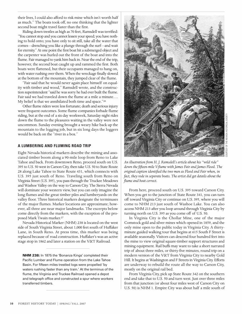
This particular flume is associated with a harrowing storyinvolving the two principals of the Bonanza firm. James C. Floodand James G. Fair decided to baptize their flume with a ride downthe mountain. H. J. Ramsdell, a reporter for the New York Tribune,was “lucky” enough to get invited along. Ramsdell found him-self at the top of the fifteen-mile run in a flume boat—little morethan a “pig trough with one end knocked out,” sixteen feet longand V-shaped like the flume. The men embarked in two boats:Fair, Ramsdell, and a “volunteered” carpenter in the front boat,and Flood in the rear boat with the flume’s construction super-intendent. Ramsdell was reluctant but reasoned that “if menworth twenty-five or thirty million apiece could afford to risk
COUR
TESY
OF
THE
NEV
ADA
HIST
ORIC
AL S
OCIE
TY
The Carson and Tahoe Lumber and Fluming Company Spooner Summit flume, looking west, 1890. Nevada Historical Marker #10 is locatednear this spot.
10 FOREST HISTORY TODAY | SPRING/FALL 2007
their lives, I could also afford to risk mine which isn’t worth halfas much.” The boats took off, no one thinking that the lightersecond boat might travel faster than the first.
Riding down trestles as high as 70 feet, Ramsdell was terrified:“You cannot stop and you cannot lessen your speed; you have noth-ing to hold onto; you have only to sit still, take all the water thatcomes—drenching you like a plunge through the surf—and waitfor eternity.” At one point the first boat hit a submerged object andthe carpenter was hurled out the front of the boat and into theflume. Fair managed to yank him back in. Near the end of the trip,however, the second boat caught up and rammed the first. Bothboats were flattened, but their occupants managed to hang on,with water rushing over them. When the wreckage finally slowedat the bottom of the mountain, they jumped clear of the flume.
“Fair said that he would never again place himself on equal-ity with timber and wood,” Ramsdell wrote, and the construc-tion superintendent “said he was sorry he had ever built the flume.Fair said we had traveled down the flume at a mile a minute….My belief is that we annihilated both time and space.”26
Other flume riders were less fortunate; death and serious injurywere frequent outcomes. Some flume companies forbade flumeriding, but at the end of a six-day workweek, Saturday night ridesdown the flume to the pleasures waiting in the valley were notuncommon. Sunday evening brought a weary hike back up themountain to the logging job, but in six long days the loggerswould be back on the “river in a box.”
A LUMBERING AND FLUMING ROAD TRIP
Eight Nevada historical markers describe the mining and asso-ciated timber boom along a 90-mile loop from Reno to LakeTahoe and back. From downtown Reno, proceed south on U.S.395 to U.S. 50 west in Carson City, then take U.S. 50 to State Route28 along Lake Tahoe to State Route 431, which connects withU.S. 395 just south of Reno. Traveling south from Reno onVirginia Street (U.S. 395), you pass through the Truckee Meadowsand Washoe Valley on the way to Carson City. The Sierra Nevadawill dominate your western view, but you can only imagine thelong flumes and the great timber piles and lumberyards on thevalley floor. Three historical markers designate the terminusesof the major flumes. Marker locations are approximate; how-ever, all three are near major landmarks. The excerpts belowcome directly from the markers, with the exception of the pro-posed Mark Twain marker.27
Nevada Historical Marker (NHM) 238 is located on the westside of South Virginia Street, about 1,000 feet south of HuffakerLane, in South Reno. At press time, this marker was beingreplaced because of road construction. Huffaker’s was an activestage stop in 1862 and later a station on the V&T Railroad.
NHM 238: In 1875 the ‘Bonanza Kings’ completed theirPacific Lumber and Flume operation from the Lake TahoeBasin. For fifteen miles trestled logs were propelled ‘bywaters rushing faster than any train.’ At the terminus of theflume, the Virginia and Truckee Railroad opened a depotand telegraph office and constructed a spur where workerstransferred timbers.
From here, proceed south on U.S. 395 toward Carson City.When you get to the junction of State Route 341, you can turnoff toward Virginia City or continue on U.S. 395, where you willcome to NHM 213 just south of Washoe Lake. You can alsoaccess NHM 213 after you loop around through Virginia City byturning north on U.S. 395 as you come off of U.S. 50.
In Virginia City is the Chollar Mine, one of the majorComstock gold and silver mines which opened in 1859, and theonly mine open to the public today in Virginia City. A thirty-minute guided walking tour that begins at 615 South F Street isavailable seasonally. Visitors can descend four hundred feet intothe mine to view original square-timber support structures andmining equipment. Rail buffs may want to take a short narratedtrip of about three miles, or thirty-five minutes, round trip on amodern version of the V&T from Virginia City to nearby GoldHill. It begins at Washington and F Streets in Virginia City. Effortsare underway to rebuild the route all the way to Carson City,mostly on the original rail bed.
From Virginia City, pick up State Route 342 on the southernend and take that to U.S. 50 and turn west. Just over three milesfrom that junction (or about four miles west of Carson City onU.S. 50) is NHM 1. Empire City was about half a mile south of
An illustration from H. J. Ramsdell’s article about his “wild ride”down the fifteen-mile V-flume with James Fair and James Flood. Theoriginal caption identified the two men as Flood and Fair when, infact, they rode in separate boats. The artist did get details about theflume and boat correct.
COUR
TESY
OF
THE
NEV
ADA
HIST
ORIC
AL S
OCIE
TY
FOREST HISTORY TODAY | SPRING/FALL 2007 11
NHM 1 on the south side of U.S. 50 (between mileposts 14 and15). Once considered the Seaport of Nevada, Empire City doesnot appear on any modern map. Near the NHM is Deer RunRoad, which runs south a short distance to the river. The dirtroad to the left at the bridge goes past the mill foundations. Allthat is left of Empire City is a cemetery and some old ore-processing mill foundations.28
From NHM 1, follow U.S. 50 west into Carson City, and thenhead north on U.S. 395 to see NHM 213. NHM 213, Lakeview, isat the top of the Lakeview Grade of U.S. 395 at the boundary ofWashoe County and Carson City. It is on the east side of the high-way, and the Lakeview interchange provides northbound accessonly. Lakeview was also a station on the V&T.
NHM 213: As early as 1881, Lakeview became a lumberstorage area for timber cut in the Lake Tahoe Basin. In 1887,shipping activity was accelerated as lumber was fed to theyard by a V-flume originating above the present InclineVillage. From here timber products were shipped toComstock mines and other points via V.&T.R.R. cars.Activity ceased in 1896.
In downtown Carson City, two museums bear mentioning.The Nevada State Museum, at 600 North Carson Street, has a300-foot tunnel illustrating a typical Nevada mine, with the var-ious kinds of timbering and support systems used by the miningindustry. Working models and full-scale exhibits illustrate thedifferent kinds of mining operations. The exhibit on square-settimbering clearly shows how the system worked. The NevadaState Railroad Museum, at 2180 South Carson Street, featuresan exhibit on the Virginia and Truckee Railroad.
NHM 193, Historic Flume and Lumberyard, is just north ofthe State Railroad Museum in a small park on the west side ofU.S. 395 at its intersection with Stewart Street.
NHM 193: Approximately one-half mile south of this pointand west of the present highway lay the immense lumber-yard of the Carson-Tahoe Lumber and Fluming Company,the greatest of the Comstock lumbering combines operat-ing in the Lake Tahoe Basin during 1870–1898. Situated atthe terminus of the 12-mile ‘V’ flume from SpoonerSummit in the Sierra Nevada, the lumberyard was approxi-mately one mile long and one-half mile wide. A spur line ofthe Virginia and Truckee Railroad served the lumberyard.The spur ran adjacent to this site and carried rough lumberto the company’s planing mill and box factory, one-halfmile north on Stewart Street. It also carried timber andcordwood to the Carson Yards to be hauled to theComstock mines and mills.
The flume from Spooner Summit ran down Clear CreekCanyon. The first right off of U.S. 395 just past the intersectionwhere U.S. 50 heads west to Glenbrook is Clear Creek Road, whichgoes partway up this canyon and ends at a government facility.The sign for Clear Creek Road is visible from the stoplight at theintersection. The road hugs Clear Creek and you can get a goodfeeling for the terrain that supported the flume. It goes only a fewmiles up the canyon and is paved all the way, but the drive is worthit. You must backtrack to get back on U.S. 50.
Once you turn right on U.S. 50, follow Clear Creek Canyon upto Spooner Summit. At the summit, about 12 miles west of CarsonCity, is NHM 261, on the left. The display includes photographsand additional history on toll roads, early motoring, and the road’s
COUR
TESY
OF
LIBR
ARY
OF C
ONGR
ESS,
GEO
GRAP
HY A
ND
MAP
DIV
ISIO
N
MAP
BY
HEAT
HER
IRW
IN
An 1874 map showing the Virginia and Truckee Railroad. Modernroads (right) closely follow the old routes.
( ((̂
((̂
395
(̂
(̂
(̂
(̂
(̂
(̂
50
(̂
(̂
395
50
50
431
28
341
Lake
Tahoe
Nevada
Cal
iforn
ia
Reno Sparks
VirginiaCity
Carson City
NHM238
NHM246
NHM221
NHM225
NHM261
NHM219
NHM193
NHM213
NHM1
Washoe
Lake
12 FOREST HISTORY TODAY | SPRING/FALL 2007
status as part of the Lincoln Highway. Photographs includeSpooner’s Station in the 1860s and 1870s, Swift’s Station, the loco-motive Tahoe unloading wood, and Summit Camp in 1876.
NHM 261: Massive amounts of wood were sent to theComstock Lode from the Carson Range and the TahoeBasin. Initially wood was hauled by wagon, but soon thetransport system included trains, steamboats, and waterflumes. Spooner Summit is in the midst of a former log-ging landscape. In 1873, logging in the area was consoli-dated by the formation of the Carson and Tahoe Lumberand Fluming Company. Workers were housed at a smallsettlement called Summit Camp, built along one side of thetoll road. From 1875 to 1898 the company operated theLake Tahoe Railroad along 8.75 miles of line fromGlenbrook to this spot. The difficult route included switch-backs and a 487-foot tunnel just west of the summit. Thenarrow-gauge railroad’s sole purpose was to haul timberand lumber for building purposes and cordwood for fuel.This wood was transferred to an 11-mile long V-flume thatextended from Spooner Summit down Clear Creek toCarson Valley. There the wood was loaded on the Virginiaand Truckee Railroad for the rest of its trip to the Comstock.At its peak the Comstock consumed about 80 million boardfeet of lumber and 2 million cords of firewood each year.About 300,000 board feet of wood passed over SpoonerSummit each day.
A short distance up U.S. 50, past the junction with State Route28, is NHM 219, Glenbrook, on the right as you approach LakeTahoe. This marker mentions King’s Canyon Road, the othermajor route to the summit. It begins in downtown Carson City(where West King Street becomes King’s Canyon Road) and runsto the north of U.S. 50. The road is currently washed out and isnot passable on the upper reaches.
NHM 219: Lumbering operations in the Glenbrook area ofLake Tahoe began in 1861. Consolidation of V-flume systemsin and near Clear Creek Canyon by 1872 made it possible tofloat lumber, cordwood, and sawed material from Spooner’sSummit to Carson City and to eliminate wagon hauling overthe 9-year old Lake Bigler Toll Road (King’s Canyon Road). In1873, the new Carson & Tahoe Lumber and FlumingCompany, under Duane Bliss, assumed all operations,becoming the largest Comstock wood and lumber combine.It controlled over 50,000 acres of timberland, operating 2 to 4sawmills, 2 Lake Tahoe steam tugs to tow logs, 2 loggingrailroads, the logging camps employing 500 men, and aplaning mill and box factory in Carson City. Timber depletionand reduced Comstock mining closed the company in 1898;it had taken 750,000,000 board feet of lumber and 500,000cords from Tahoe Basin forests during its lifetime.
Backtrack to State Route 28 for NHM 225, Spooner Area,which addresses logging and lumbering from 1868 to 1895. It is
The Carson City lumber yard, facing north, ca. 1876. Engine I.E. James is in the foreground. The area is now the site of the State Railroad Museum.
COUR
TESY
OF
THE
NEV
ADA
STAT
E RA
ILRO
AD M
USEU
M
FOREST HISTORY TODAY | SPRING/FALL 2007 13
located inside Spooner Park, just past the guardhouse, on theright as you exit the park. (If you are going just to read the his-torical marker, you can likely talk the guard into forgoing theentrance fee.)
NHM 225: This area bears the name of Michele E. Spooner,a French Canadian entrepreneur, who, along with others,was instrumental in establishing the wood and lumberindustry which supplied the needs of the Comstock minesand mills. In 1868 Spooner became a partner with Oliverand John Lonkey, the Elliot Brothers, Henry M. Yerington,William Fairburn and Simon Dubois in the Summit FlumingCompany and operated a shingle mill and sawmill. In 1870Yerington, Bliss & Company took over the Summit FlumingCompany. In 1873 another sawmill was erected at SpoonerMeadows. Later in 1873, all the mills were taken over by the Carson & Tahoe Lumber and Fluming Company. Thiscompany, headquartered in Glenbrook, went on to becomethe largest of the three huge combines supplying wood and lumber to the Comstock.
Using his real name, Samuel Clemens, Mark Twain onceworked as a reporter on the Virginia City newspaper, the TerritorialEnterprise; a historical marker there notes his time in the city andthat there he adopted his nom de plume. Before that, he tried andfailed as a miner and then as a “timber rancher.” This unsuccess-ful venture took place near Glenbrook, and while it has no his-torical marker, what happened there is worthy of one. In 1861the Comstock’s demand drove up the price of wood, and manythought they could become wealthy by meeting it. Clemens and
a friend decided this was a wonderful opportunity to see “the mar-velous beauty of Lake Tahoe” and “to take up a wood ranch orso ourselves and become wealthy.” If there were a historicalmarker it would read:
In 1861, Samuel Clemens (“Mark Twain”) visited Lake Tahoeto seek riches by establishing a timber ranch. He and afriend set out on foot from Carson City and first crossed amountain “about a thousand miles high” and then another“three or four thousand miles high” and eventually burstupon Lake Tahoe. He described it as “a noble sheet of bluewater lifted six thousand three hundred feet above the levelof the sea, and walled in by a rim of snow-clad mountainpeaks that towered aloft full three thousand feet higherstill!” They claimed a 300-acre timber ranch. A few dayslater, Mark Twain’s campfire is credited with starting a majorwildfire on the shores of Lake Tahoe that devoured muchmore than his timber ranch and burned for four hoursbefore it left his range of vision. Mark Twain later describedit in his book, Roughing It: “The ground was deeply carpetedwith dry pine needles and the fire touched them off as ifthey were gunpowder. It was wonderful to see with whatfierce speed the tall sheet of flame traveled! My coffeepotwas gone, and everything with it. In a minute and a half thefire seized upon a dense growth of dry manzanita chaparralsix or eight feet high, and then the roaring and popping andcrackling was terrific.... Within a half an hour all before uswas a tossing, blinding tempest of flame!…till as far as theeyes could reach the lofty mountain fronts were webbed asit were with a tangled network of red lava streams.”29
The Carson and Tahoe Lumber and Fluming Company’s flume in Clear Creek Canyon. Clear Creek Road follows the old flume route.
COUR
TESY
OF
THE
NEV
ADA
STAT
E RA
ILRO
AD M
USEU
M
14 FOREST HISTORY TODAY | SPRING/FALL 2007
NHM 221, Sand Harbor, is on the left at Lake Tahoe StatePark, at the Sand Harbor boat ramp.
NHM 221: History records Sand Harbor as playing animportant role in the operations of the Sierra Nevada Woodand Lumber Company, one of three large combines supply-ing lumber and cordwood to the Comstock mines duringthe late 19th century. Walter Scott Hobart organized thecompany and John Bear Overton was its general manager.The steamer ‘Niagara’ towed log rafts from company landat the south end of Lake Tahoe to Sand Harbor. Here thelogs were loaded on narrow-gauge railway cars and takentwo miles north to a sawmill on Mill Creek. Lumber andcordwood were started on the way to Virginia City via anincline tramway 4,000 feet long, and rising 1,400 feet up themountainside where the material was transferred to waterflumes and transported to Lakeview just north of CarsonCity. The tramway has been described as ‘the Great Inclineof the Sierra Nevada.’
NHM 246, “The Great Incline of the Sierra Nevada,” is locatedon the right side of State Route 28 in Incline Village.30
NHM 246: The scars on the mountain above are the rem-nants of the ‘Great Incline of the Sierra Nevada.’ Completedin 1880, this 4,000-foot-long lift was constructed by theSierra Nevada Wood and Lumber Company. A uniquesteam-powered cable railway carried cordwood and lumberup 1,800 feet to a V-flume which carried the lumber down toWashoe Valley where it was loaded on wagons for use in themines of the Comstock. Driven by an engine on the summit,8,000 continuous feet of wire cable, wrapped aroundmassive bull wheels pulled canted cars up a double tracktramline. This engineering feat would transport up to 300cords a day from the mill located on what is now Mill Creek.
From Incline Village, take State Route 431 back toward U.S.395 and stop at the vista area, where a metal plaque locates allthe Lake Tahoe Basin sites you have just visited. It gives greatperspective to the geography of the lumbering operations and
COUR
TESY
OF
THE
NEV
ADA
HIST
ORIC
AL S
OCIE
TY
“The Great Incline of the Sierra Nevada,” around 1885. The incline rose 1,400 feet up the mountainside. From there, lumber was transferred towater flumes and transported to Lakeview just north of Carson City. It is now the location of Nevada Historical Marker #17.
FOREST HISTORY TODAY | SPRING/FALL 2007 15
the opportunity to take in a great view of Lake Tahoe from theNevada side. From there, take U.S. 395 north back to Reno.
Once you understand how the markers are connected, the pic-ture of Lake Tahoe Basin logging becomes clearer. Having seenthe mountains down which the flumes delivered timber, you willbetter understand what it was like to get timber out of the basinand see the connection between one of the biggest mining oper-ations in American history and a large piece of forest history. ��
Thomas J. Straka is a professor in the Department of Forestry andNatural Resources at Clemson University in South Carolina. He has akeen interest in Nevada history and has completed this tour from Renomany times.
NOTES1. William Wright (Dan De Quille), The Big Bonanza (1876; repr., New
York: Alfred A. Knopf, 1947), 24–29. This is likely the most-cited“authentic account of the discovery, history, and working of the world-renowned Comstock Lode of Nevada,” written by a reporter forVirginia City’s Territorial Enterprise. Finney, Comstock, and the otherearly prospectors did not make much money off the Comstock Lode,and many of them died penniless.
2. Russell R. Elliott, History of Nevada (Lincoln: University of NebraskaPress, 1987), 83–84. Nevada’s early admission stemmed from PresidentAbraham Lincoln’s need for the electoral votes in the 1864 election andcongressional votes for his Reconstruction package.
3. Oscar Lewis, Silver Kings: The Lives and Times of Mackay, Fair, Flood, andO’Brien, Lords of the Nevada Comstock Lode (New York: Alfred A. Knopf,1947). Early financial control of the Comstock Lode was by the “BankCrowd,” primarily the Bank of California, represented by WilliamSharon. By 1875 control shifted to the Bonanza firm, and the “lords” ofthe Comstock Lode became John W. Mackay, James G. Fair, James C.Flood, and William S. O’Brien.
4. Grant H. Smith, The History of the Comstock Lode: 1850–1997 (Reno:University of Nevada Press, 1998) 7–11.
5. Elliott, History of Nevada, 96–97.6. Wright, Big Bonanza, 89–92.7. Sam P. Davis, ed., The History of Nevada, vol. 1 (Reno, NV: Elms
Publishing Co., 1913), 410. 8. Wright, Big Bonanza, 174–180.9. Eliot Lord, Comstock Mining and Miners (Washington, DC: Government
Printing Office, 1883), 351. Mines used lots of fuelwood: Ore washoisted up with steam engines, pumps constantly cleared the mines ofwater, and lots of mines had stamp mills onsite, which used lots ofsteam. They even had power drills that ran on steam.
10. Wright, The Big Bonanza, 174.11. Ibid., 175.12. Myron Angel, ed., History of Nevada (Oakland, CA: Thompson and
West, 1881), 188.13. Smith, History of the Comstock Lode, 247–248.14. Angel, History of Nevada, 188–191.15. John D. Galloway, Early Engineering Works Contributing to the Comstock
(University of Nevada Bulletin No. 5, Geology and Mining Series No.45. Nevada State Bureau of Mines and the Mackay School of Mines,Reno, 1947), quoted in: Dennis D. Murphy and Christopher M. Knopp,eds., Lake Tahoe Watershed Assessment, vol. I (USDA Forest ServiceGeneral Technical Report PSW-GTR-175, Albany, CA: PacificSouthwest Research Station, 2000), 51.
16. Wright, Big Bonanza, 178–79.17. Stanley W. Paher, Nevada Ghost Towns and Mining Camps (Berkeley, CA:
Howell-North Books, 1970), 47–51. This book contains a wonderful setof five photographs of Carson River wood drives.
18. Elliott, History of Nevada, 126–28. 19. Angel, History of Nevada, 188–90.20. Edward B. Scott, The Saga of Lake Tahoe (Lake Tahoe, NV: Sierra-Tahoe
Publishing Co., 1957), 263–74, 291–97. See also Elliott, History ofNevada, 139–40.
21. Scott, Saga of Lake Tahoe, 305–12. See also Elliott, History of Nevada,140.
22. Scott, Saga of Lake Tahoe, 306.23. Ibid.24. Wright, Big Bonanza, 176–77.25. Elliott, History of Nevada, 140–41. Nevada State Route 431 is also called
Mount Rose Highway.26. The story ended up in the paper and eventually as an amusing maga-
zine article: Bert Goldrath, “River in a Box,” Argosy 352 (March 1961):34–39, 104–105.
27. Dave Basso, Nevada Historical Marker Guidebook (Las Vegas: NevadaPublications, 1986). The Nevada State Historic Preservation Officemaintains an up-to-date list of markers athttp://dmla.clan.lib.nv.us/docs/shpo/markers. Ronald M. James andMara Thiessen Jones from that office provided valuable backgroundused in this article.
28. Mary E. and Al Glass, Touring Nevada: A Historic and Scenic Guide (Reno:University of Nevada Press, 1983), 32–33. This book contains fascinat-ing road tours of Nevada. On pages 31–34 is the Comstock Lode tour,which includes Virginia City.
29. Samuel Clemens (Mark Twain), Roughing It (1872; repr., New York:Penguin Group, 1962), 133–41.
30. The marker incorrectly states that the incline was 1,800 feet in length.It was 1,400 feet, as is stated on NHM 221.