19
Background Report December 2014 Date endorsed by WAPC Tjukurla Layout Plan 2 Amendments Amendment 1 - February 2018 Amendment 2 - September 2020

Background Report
December 2014 Date endorsed by WAPC
TjukurlaLayout Plan 2
Amendments Amendment 1 - February 2018Amendment 2 - September 2020

___________________________________________________________________________________________________________Planwest (WA) Pty Ltd Tjukurla Community Layout Plan No.2
1
CONTENTS
CONTENTS ...................................................................................................................................... 1
CONTACTS & CONSULTATION ...................................................................................................... 2
EXECUTIVE SUMMARY .................................................................................................................. 3
1. BACKGROUND ....................................................................................................................... 4
2. EXISTING SITUATION ............................................................................................................ 5
3. REGIONAL TOWN PLANNING ............................................................................................... 8
4. LOCAL TOWN PLANNING ...................................................................................................... 8
5. COMMUNITY ASPIRATIONS .................................................................................................. 8
6. DEVELOPMENT PROJECTS & REQUIRED IMPROVEMENTS ............................................ 9
7. CONSULTATION SUMMARY ............................................................................................... 10
8. ENDORSEMENTS ................................................................................................................. 11
Tjukurla Aboriginal Corporation Endorsement .................................................................. 12 Yarnangu Ngaanyatjarraku Parna Aboriginal Corporation Endorsement ......................... 13 Shire of Ngaanyatjarraku Endorsement ........................................................................... 14 Western Australian Planning Commission Endorsement ................................................. 15
9. AMENDMENTS ..................................................................................................................... 16
NOTE:
The Tjukurla Community Layout Plan No.2 was prepared during 2007 and 2008 by planning consultants Planwest (WA) Pty Ltd on behalf of the Department for Planning and Infrastructure. The plan was not endorsed by any party at that time.
The report and map-set are substantially as per the version prepared in consultation with the community in 2008, but do include: updated data as appropriate, including changes that are a consequence of the conversion of the map-set from CAD to GIS.

___________________________________________________________________________________________________________Planwest (WA) Pty Ltd Tjukurla Community Layout Plan No.2
2
CONTACTS & CONSULTATION Community Contacts
Corporation Tjukurla Aboriginal Corporation
Telephone 8956 7388
Fax 8956 7345
Email [email protected]
Postal Address Tjukurla Community, PMB 37, Via Alice Springs 0872
PRESCRIBED BODY CORPORATE
Nominated Prescribed Body Corporate:
Yarnangu Ngaanyatjarraku Parna (Aboriginal Corporation)

___________________________________________________________________________________________________________Planwest (WA) Pty Ltd Tjukurla Community Layout Plan No.2
3
EXECUTIVE SUMMARY
Preamble
The Tjukurla Community is remote. Its locational difficulty is not just the distance but the time. The quality of the road access to the community is very poor and in some locations speeds need to be reduced to 40km/hr.
The level of development in the community is generally reasonable, the roads, although not sealed are in good condition, as is the majority of the infrastructure. However, due to its remoteness, servicing is difficult and expensive.
Development at Tjukurla This Community Layout Plan includes the following development and works.
Within the next year 1. A new rubbish tip 2. A community use complex to support the community garden, arts and crafts centre
and women’s centre.
Within the next 5 years 1. Several future residential areas. 2. Visitor camping area.
___________________________________________________________________________________________________________Planwest (WA) Pty Ltd Tjukurla Community Layout Plan No.2
4
1. BACKGROUND
Location
The community area is located 80 kilometres north of the Great Central Road. The community is situated about 166km north-east of Warakurna and approximately 30 kilometres west of the Northern Territory border.
Climate
Tjukurla has a climate that is classified as sub-tropical by BoM. Characterised by summer rainfall and dry winters. Summers are hot, and winter mild to cool.
Mean daily temperature ranges;
22-37 in summer
6-20 in winter
Average annual rainfall; 168mm
History
In the early 1980s a bore was put down near what is today Tjukurla. This was a part of what was then a vibrant and energetic outstation movement. In mid 1981 an outstation was established at Kintore which provided an opportunity for those living at Papunya to move west, closer to their traditional lands. From Kintore many people moved to Tjukurla as that community’s infrastructure developed. Residents also came from Warakurna and Docker River. It is understood that a small number of people also relocated from Warburton. By 1986 the community was permanently occupied and in the following year it became incorporated and a member of the Ngaanyatjarra Council.
Governance
The land is owned by the Aboriginal Lands Trust. The Shire of Ngaanyatjarraku and the Community Council determine project approval, and obtain support from Ngaanyatjarra Council as the traditional owners of the land.
Previous Layout Plans
Layout Plan No.1 was prepared in March 2002 by Connell Wagner, but was not endorsed by any party.

___________________________________________________________________________________________________________Planwest (WA) Pty Ltd Tjukurla Community Layout Plan No.2
5
2. EXISTING SITUATION Land Tenure
Tjukurla is on one land parcel, being:
Lot 9 Crown Reserve 17614 i
Crown Lease GE I798552 leased to the Community
Aboriginal Lands Trust owned
8 023 546.09 ha
The land tenure map clearly shows the land ownership situation at Tjukurla. Lot 9 is extraordinarily large, being just over 80,000 square kilometres. Several other settlements distant from Tjukurla are also on Lot 9.
Native Title
Native Title was determined in 2005 covering the majority of the Shire area and a portion of the Laverton Shire.
Justice Black determined that the Ngaanyatjarra people held NT Rights and interests to the exclusion of all others. See details at www.nntt.gov.au .
Access & Dedicated Roads
The road system in the locality of the community is not a dedicated network. All roads are on Lot 9. Generally, the roads are all-weather roads but can be problematic in wet weather conditions.
Population
Notwithstanding the EHN survey (2008) a core of about 114 is expected as a stable population throughout the year. The population can vary from 10 to 1500 - depending on funerals or law periods. The 2001 Censusii counted 130 people. In a field visit in 2002 there were an additional 30 people from the Kiwirrkurra.
Housing
There are 27 houses at Tjukurla.
Stormwater Drainage
There is no formal drainage system in or about the community. Very heavy rains have caused flooding in the community area.
___________________________________________________________________________________________________________Planwest (WA) Pty Ltd Tjukurla Community Layout Plan No.2
6
Community and Social Services
The existing primary and pre-primary schools are staffed by 3 resident teachers and 3 teacher aids. The existing clinic is staffed by a resident nurse and 2 health workers. The community has a small church. There is no police station. Warakurna station provides the service where required. The cemetery is located about 2.3 kilometres south of the community
Electricity Supply
There is a reticulated electricity network servicing Tjukurla. The power supply is provided by the Department of Housing, which is an unregulated supplier. There are 3 diesel generators with a 29,000 litre storage located south west of the community. These generators operate 24 hours a day and are considered reliable.
Wastewater
There is no reticulated waste water service at Tjukurla. Each dwelling in the community has a septic tank and leach drain system.
Water Supply
There is a reticulated drinking water network servicing Tjukurla. The drinking water service is provided by the Department of Housing, which is an unregulated supplier. Tjukurla does not have a Drinking Water Source Protection Plan.
The Tjukurla drinking water source is currently from a bore located about 3.6 kilometres east of the community. The bores are solar powered. A comment in the community has been made that the solar powered bores may be too close to a rock hole frequently used by large numbers of camels. The presence of the camels is impacting on the water quality from the bores.
A back-up bore is located about 1.7 kilometres south of the community on the edge of the main entry road. The bore is diesel powered and manually operated by setting a time clock so it pumps for a given period (eg 24 hours). This is necessary when the weather is overcast and the solar pumps cannot operate. There are plans to install a remote operating system in the future. Current demand is about 145KL/day.
Rubbish Disposal
The existing Tjukurla rubbish tip is located 700 metres south west of the community. The tip is community operated with the Shire assisting with upgrades. The tip is unregulated.
Also located south west of the community (only about 300 metres away) is a wrecking yard mainly for old motor vehicles. It was suggested that this was too close to the community area and should be relocated further away to the south west.

___________________________________________________________________________________________________________Planwest (WA) Pty Ltd Tjukurla Community Layout Plan No.2
7
Air Strip
The Tjukurla Air Strip is located 1.8 kilometres south east of the community. It is a dry weather day/night unsealed gravel sheeted landing strip built to RFDS standard. There is a single runway nearly 2 kilometres long.
Mechanical Workshop
There are two workshops in the community, one is CDEP run. Near to the workshops is the power station and a fuel supply. The fuel supply provides Opal fuel in underground tanks and diesel in a raised small tank.
Outstations
Turkey Bore, Yulpikarri, Larrara, Kuruyultu, Puyur and Karku.
Culturally Sensitive Areas
The area north of the community area has been identified as a culturally significant area (men’s ‘no go’ area) and should not form part of any CLP proposals. There exists a power line into the north of the community (running east west) that could service new houses but it was suggested that this would be inappropriate. It is recommended that this portion of power line be removed to avoid any temptation to use the service later on. A women’s area has been mentioned but it is included in the men’s ‘no go’ area.
Visitor Camping
Camping/visitors area has been designated on the CLP. This was suggested to be located south of the community area. One group suggested about a kilometre south whilst another group suggested only about 200 metres south.
.

___________________________________________________________________________________________________________Planwest (WA) Pty Ltd Tjukurla Community Layout Plan No.2
8
3. REGIONAL TOWN PLANNING Regional Planning
There is no operative Regional Planning Scheme covering Tjukurla.
State Planning Policies
State Planning Policies are prepared and adopted by the WAPC under statutory procedures set out in section 26 of the Planning and Development Act 2005.
The WAPC and local governments must have 'due regard' to the provisions of statements of planning policy when preparing or amending town planning schemes and when making decisions on planning matters. The State Administrative Tribunal is also required to take account of statements of planning policy when determining appeals.
The following SPPs were given due regard in the preparation of CLP No.2:
SPP 3 - Urban Growth and Management
SPP 3.2 - Planning for Aboriginal Communities
SPP 2.7 - Public Drinking Water Source
4. LOCAL TOWN PLANNING
There is no operative Local Planning Scheme or Local Planning Strategy covering Tjukurla.
5. COMMUNITY ASPIRATIONS
Providing sufficient standard of living for the current population of Tjukurla and future residents is dependent on maintaining and improving the existing facilities and making sure that there is the right mix of housing and other uses. There is an understanding that development of Tjukurla is something that has taken time, and will happen over many years. The ideas for improvements to the facilities noted by the Tjukurla Aboriginal Corporation when developing the Community Layout Plan are listed below. Not all of these aspirations can be incorporated into a CLP, but have been noted as a record of a more general community improvement plan.
1. The Community purposes area to provide for a wide range of community uses including the community garden, women’s and men’s centres and arts centre.
2. Renovation of 4 houses.
3. Continued development of Community orchard.
4. Creation of an industrial area.
5. Substantial future residential areas.
6 Creation of Visitor Camping area.
7. Need a nurse for 2 nights per week.

___________________________________________________________________________________________________________Planwest (WA) Pty Ltd Tjukurla Community Layout Plan No.2
9
6. DEVELOPMENT PROJECTS & REQUIRED IMPROVEMENTS Design Summary
The future plans for Tjukurla are based on visits to the community and advice from relevant government agencies, including the Remote Area Essential Services Program (RAESP) managers Parson Brinkerhoff, surveyors Sinclair Knight Merz, Shire of Ngaanyatjarraku and the 2002 Connell Wagner CLP report.
The general design principles of the plan are:
1. Maintain adequate separation between incompatible uses.
2. Define a road network that is suitable for all uses, including water, electricity, and other services.
3. Plan for future growth by developing new residential lots.
4. Allocate land for a range of land uses that may be needed in the future.
The Tjukurla Community Layout Plan shows all proposed improvements to Tjukurla. The plan is included in section 9 of this report. The following provides a brief explanation of the design principles and required improvements that are shown on the plan.
Road Layout
Road alignments mostly follow used roads. New roads will need construction some time in the future. There are some major changes to the Connell Wagner plan including;
the airstrip road into the community being maintained as a direct route;
deletion of the 4 way intersection that runs through the church;
additional housing area being located south of the community area;
additional land areas towards the oval (for future staff housing).

___________________________________________________________________________________________________________Planwest (WA) Pty Ltd Tjukurla Community Layout Plan No.2
10
7. CONSULTATION SUMMARY Preparation of this Community Layout Plan is the result of consultation with the community representatives and a range of agencies, authorities, non-government organisations. This has included referral letters to the following agencies. Organisation Date Community consultation includes the following; Visit 1 No contact. VISIT 2 No contact. VISIT 3 Met with Lindsay Jones (CDA), Judy and Laurie (store manager and CD officer). Marlene Young (Chairperson) was in Adelaide. Met with Lyal Giles (Community Elder) and discussed CLP. No real issues were raised, and support for the plan was offered.
July 2006 August 2006 28 April 2008
Department of Indigenous Affairs Letter dated 7 Feb 2006 Advice of Act, list of sites Response 24 Feb 2006 Aboriginal Lands Trust Letter dated 7 Feb 2006 Local Government Met with CEO and the
Council on several occasions regarding CLPs and LPS.
Main Roads WA Letter dated 7 Feb 2006 Upgrades, permits vs road reserve, mining vs roads Response May 2006 Department for Housing & Works Letter dated 7 Feb 2006 Department of Education, Training & Employment Letter dated 7 Feb 2006 Agriculture and Food Dept Letter dated 7 Feb 2006 WA Water Corporation Letter dated 7 Feb 2006 Conservation and Land Management Letter dated 7 Feb 2006 CALM estate received from Kalgoorlie office Response March 2006 Environmental Protection Authority Letter dated 7 Feb 2006 Refers to Guidance No 33 and web site Response March 2006 Parsons Brinkerhoff Data on Global Groundwater April 2006 Department for Planning & Infrastructure/WAPC Letter dated 7 Feb 2006 FESA Letter dated 7 Feb 2006 GEDC Letter dated 7 Feb 2006 WA Tourism Commission Letter dated 7 Feb 2006 Supports Eco tourism, Highway access, checklist Response April 2006 Waters and Rivers Commission Letter dated 7 Feb 2006 Department of Industry and Resources Letter dated 7 Feb 2006 Education Dept WA Letter dated 7 Feb 2006 Enrolment stats – no new schools in the region Response March 2006 City of Canning (Paul Todd EHO for Shire of NG) March-May 2009

___________________________________________________________________________________________________________Planwest (WA) Pty Ltd Tjukurla Community Layout Plan No.2
11
8. ENDORSEMENTS


___________________________________________________________________________________________________________Planwest (WA) Pty Ltd Tjukurla Community Layout Plan No.2
13
Yarnangu Ngaanyatjarraku Parna Aboriginal Corporation Endorsement
Tjukurla Layout Plan No.2
The Yarnangu Ngaanyatjarraku Parna Aboriginal Corporation (representing the traditional owners) hereby adopts the Tjukurla Layout Plan No. 2 (2008) as a basis for future growth and development within Tjukurla community.
The …………………………Day of ………………………………2014
Representative 1 Representative 2
(Please print and sign name) (Please print and sign name)

___________________________________________________________________________________________________________Planwest (WA) Pty Ltd Tjukurla Community Layout Plan No.2
14
Shire of Ngaanyatjarraku Endorsement
Tjukurla Layout Plan No.2
The Shire of Ngaanyatjarraku hereby adopts the Tjukurla Layout Plan No. 2 (2008) as a basis for future growth and development within Tjukurla community.
The …………………………Day of …………………………………… 2012
Endorsed by the Shire of Ngaanyatjarraku:
Shire President CEO
(Please print and sign name) (Please print and sign name)
Council
Seal


___________________________________________________________________________________________________________Planwest (WA) Pty Ltd Tjukurla Community Layout Plan No.2
16
9. AMENDMENTS

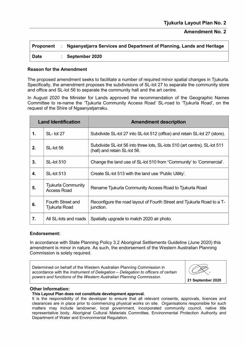
Tjukurla Layout Plan No. 2 Amendment No. 2
Proponent : Ngaanyatjarra Services and Department of Planning, Lands and Heritage
Date : September 2020
Reason for the Amendment
The proposed amendment seeks to facilitate a number of required minor spatial changes in Tjukurla. Specifically, the amendment proposes the subdivisions of SL-lot 27 to separate the community store and office and SL-lot 56 to separate the community hall and the art centre. In August 2020 the Minister for Lands approved the recommendation of the Geographic Names Committee to re-name the ‘Tjukurla Community Access Road’ SL-road to ‘Tjukurla Road’, on the request of the Shire of Ngaanyatjarraku.
Land Identification Amendment description
1. SL- lot 27 Subdivide SL-lot 27 into SL-lot 512 (office) and retain SL-lot 27 (store).
2. SL-lot 56 Subdivide SL-lot 56 into three lots, SL-lots 510 (art centre), SL-lot 511 (hall) and retain SL-lot 56.
3. SL-lot 510 Change the land use of SL-lot 510 from “Community’ to ‘Commercial’.
4. SL-lot 513 Create SL-lot 513 with the land use ‘Public Utility’.
5. Tjukurla Community Access Road Rename Tjukurla Community Access Road to Tjukurla Road
6. Fourth Street and Tjukurla Road
Reconfigure the road layout of Fourth Street and Tjukurla Road to a T-junction.
7. All SL-lots and roads Spatially upgrade to match 2020 air photo.
Endorsement:
In accordance with State Planning Policy 3.2 Aboriginal Settlements Guideline (June 2020) this amendment is minor in nature. As such, the endorsement of the Western Australian Planning Commission is solely required.
Other Information: This Layout Plan does not constitute development approval. It is the responsibility of the developer to ensure that all relevant consents, approvals, licences and clearances are in place prior to commencing physical works on site. Organisations responsible for such matters may include landowner, local government, incorporated community council, native title representative body, Aboriginal Cultural Materials Committee, Environmental Protection Authority and Department of Water and Environmental Regulation.
Determined on behalf of the Western Australian Planning Commission in accordance with the Instrument of Delegation – Delegation to officers of certain powers and functions of the Western Australian Planning Commission.
21 September 2020


