1 Topics Geo Annual review: Natural catastrophes 2005 Knowledge series Natural catastrophes in 2005 Great natural catastrophes since 1950 Hurricane season – Time to rethink The Kashmir quake The climate conference in Montreal Climate review 2005
Supervisory BoardDr. jur. Hans-Jürgen Schinzler (Chairman), Herbert Bach, Hans-Georg Appel, Holger Emmert, Ulrich Hartmann, Dr. rer. nat. Rainer Janßen, Prof. Dr. rer. nat. Henning Kagermann, Prof. Dr. rer. nat. Drs. h. c. mult. Hubert Markl,Wolfgang Mayrhuber, Kerstin Michl, Prof. Karel Van Miert, Ingrid Müller, Prof. Dr. jur. Dr.-Ing. E. h. Heinrich v. Pierer, Dr. e. h. Dipl.-Ing. Bernd Pischetsrieder, Dr. rer. nat. Jürgen Schimetschek, Dr. jur. Dr. h. c. Albrecht Schmidt, Dr. phil. Ron Sommer, Wolfgang Stögbauer,Josef Süßl, Judy Võ
Responsible for contentCorporate Underwriting/Global ClientsGeo Risks Research/Environmental Management
The broad range of Munich Re’s geoscientificknowledge may be found at www.munichre.com.Besides supplying basic scientific and insuranceinformation on the subject of natural hazards, it presents analyses of topical loss events andinteractive hazard maps for all regions of theworld.
1
Munich Re, Topics Geo 2005 Contents
Natural catastrophes in 2005Review – OutlookPictures of the yearStatistics
Great natural catastrophes 1950–2005
NatCatSERVICE informationIncreasing intensity and costs of natural catastrophes – Is this a long-term trend?
Hurricane season 2005
Earthquake in Pakistan
Floods and stormsSummer 2005 in central Europe: Many Alpine valleys under waterFloods in Mumbai
Geographical underwriting – A central component of risk management
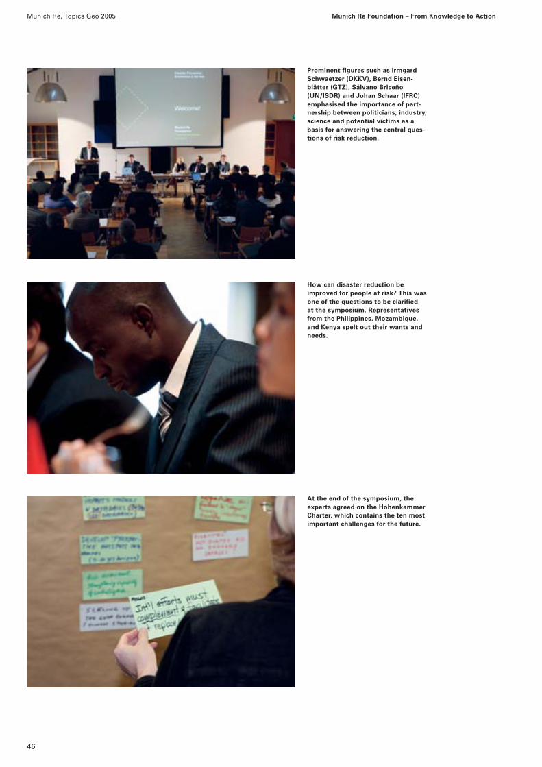
Munich Re Foundation – From Knowledge to ActionRisk awareness is the key
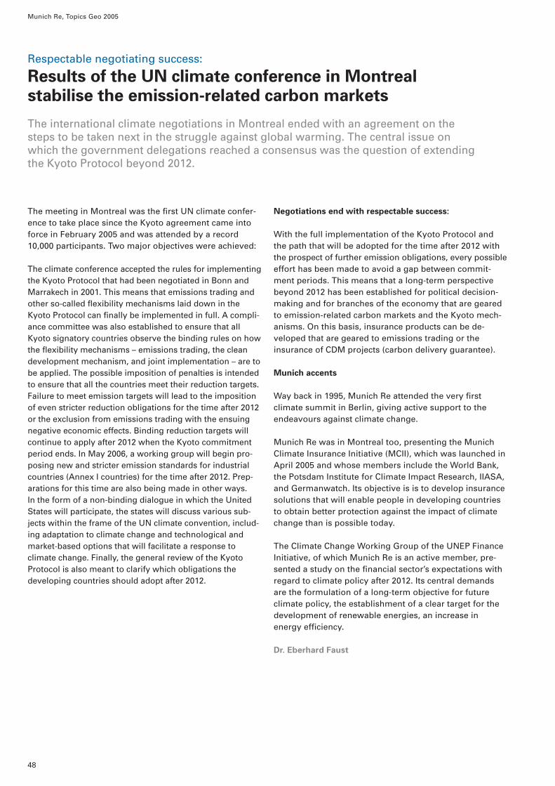
Results of the UN climate conference in Montreal
Climate review 2005
InsertsWorld Map of Natural Catastrophes 2005MRNatCatPOSTER Natural catastrophes in 2005
Page
268
10
14
18
30
3438
41
45
48
51
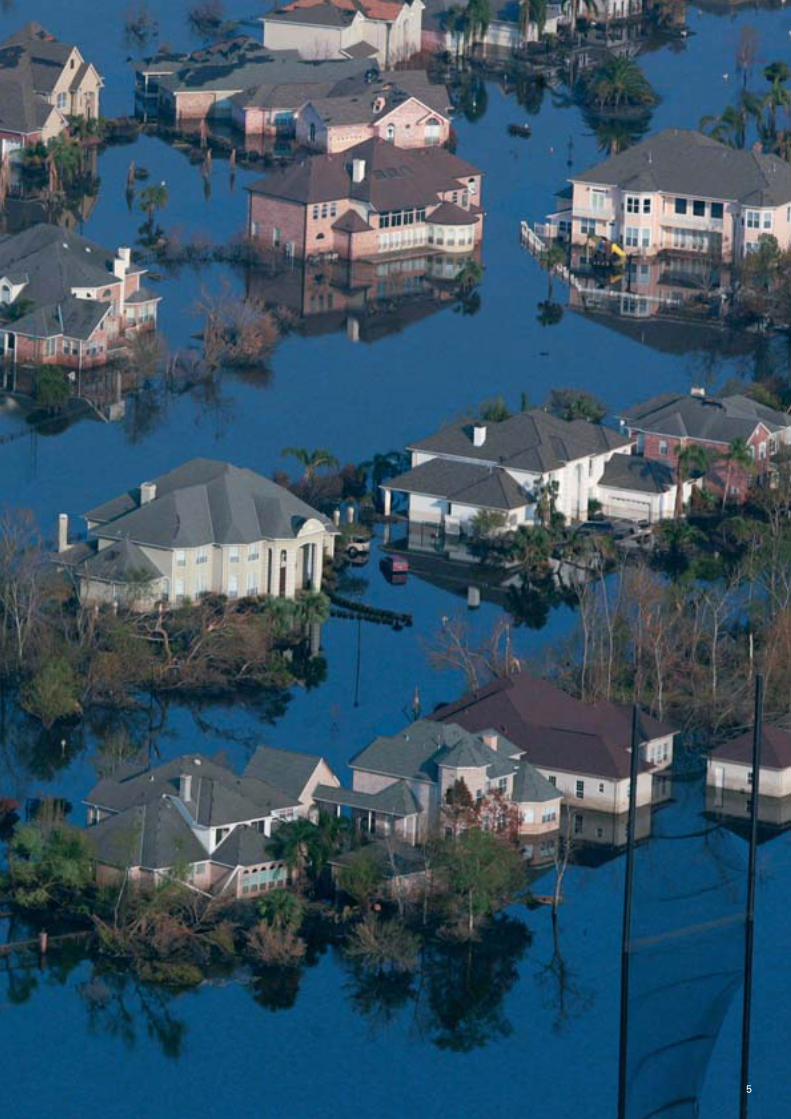
Cover:2005 was the most active hurricane season since recordings began and the most expensivein the history of the insurance industry. Thiswas the flooded centre of New Orleans at theend of August after Hurricane Katrina. The Superdome provided shelter for 20,000 home-less people. However, a further evacuation was imperative as the Superdome’s roof hadbeen damaged in the storm, and supplying thepeople with provisions was difficult in theflooded city.
Left:The first evacuees from New Orleans arrived in Houston on 31 August. More than 24,000homeless people crowded into the Astrodome,where they received all they needed. It was the largest emergency shelter in the history of the American Red Cross.
Munich Re, Topics Geo 2005
2
Katrina was the sixth strongest hurricane since recordingsbegan in 1851 – and losses amounting to US$ 60bn (private insurance: US$ 45bn; National Flood InsuranceProgram: US$ 15bn) made it the most expensive naturalcatastrophe loss in history. Rita, the fourth strongesthurricane ever registered, reached mean wind speeds of up to 280 km/h. Stan progressed at a relatively slowspeed but carried enormous amounts of rain into MiddleAmerica, causing thousands of landslides, under whichmore than 800 people were buried. Wilma was thestrongest hurricane ever registered in the Atlantic, withoverall losses amounting to approx. US$ 18bn. At the end of November, Delta became the first tropical cycloneever to be registered in the Canaries. You will find adetailed description of the 2005 hurricane seasonbeginning on page 18.
Munich Re has also published a special brochure entitled“Hurricanes – More intense, more frequent, more expen-sive“, which describes the effects on the insurance indus-try and summarises the conclusions to be drawn.
Geological events
In the past year, 70 damaging earthquakes and 13 vol-canic eruptions were registered around the world. Theoverall loss came to approx. US$ 6bn.
In February 2005, a 6.5-magnitude earthquake occurred in Iran. Although the region affected is only sparsely pop-ulated, more than 600 people were killed. In March, an8.7-magnitude earthquake occurred off the coast of Suma-tra, demolishing thousands of houses on the island ofNias and killing 1,700 inhabitants. The earthquake that hitthe border region between Pakistan and India in October2005 triggered one of the worst human catastrophes ofthe last one hundred years. It only lasted 50 seconds, butmore than 2,000 settlements were almost completely destroyed and 88,000 people were killed. Thousands oflandslides blocked the roads to the areas with the greatestdevastation and thus prevented international aid organi-sations from taking prompt and effective action. Furtherdetails may be found in the article beginning on page 30.
2005, the year of records
The year 2005 was marked by weather-related natural catastrophes. Roughly half of all the loss events recordedwere windstorms, with costs to be borne by the world’seconomies exceeding US$ 185bn. The most severe human catastrophe was triggered by an earthquake that occurred in October in the border area between Pakistanand India and, with a death toll of 88,000, was one of thefive most destructive quakes of the last 100 years.
Loss figures
Overall losses exceeding US$ 210bn set a new record (the most expensive year before that was 1995 with US$ 175bn, in original values), although, with some650 loss events registered, the number of natural catas-trophes was in line with the average of the last ten years.More than one hundred thousand people were killed as aresult of natural catastrophes last year. Such a large num-ber of fatalities has been recorded only twice in the last25 years: in 1991, following a storm surge in Bangladesh,and 2004, following the tsunami in South Asia.
Consequently, it is not surprising that insured losses alsoreached unprecedented dimensions. The year’s overallbalance for the insurance industry was US$ 94bn, doub-ling the previous record set in 2004.
Windstorms
As in previous years, windstorms dominated the insurers’loss figures. In January, Winter Storm Erwin crossed Scotland and southern Scandinavia at up to 120 km/h on a path that took it as far as Russia. It was the strongeststorm in Norway for over ten years, in Sweden for overthirty years. For the European insurance industry, it wasthe fifth most expensive storm of the past fifty years.
The hurricanes in the United States, the Caribbean, andMexico alone destroyed insured values exceeding US$ 83bn. In the Atlantic, 27 tropical storms and hurri-canes broke all meteorological and monetary records. For the first time since its introduction in 1953, the offi-cial list of 21 names was not long enough and had to be supplemented by the first six letters of the Greekalphabet.
Natural catastrophes in 2005Review – Outlook
3
Munich Re, Topics Geo 2005 Natural catastrophes in 2005: Review – Outlook
Floods
In August 2005, profuse rainfall caused floods in nearly all Alpine countries. You can read more on this occur-rence, the largest loss incurred by the Swiss Natural Perils Pool in its 30-year history, in the article beginningon page 34. Mumbai, the megacity on the west coast ofIndia with over 15 million inhabitants, was swamped byextreme rainfalls in July 2005. A precipitation depth of944 mm was recorded within 24 hours, almost as much as the annual average. Our description of this natural catastrophe, the most expensive insurance loss in Indiato date, begins on page 38.
Wildfires, heatwaves, and droughts
In August, the scene in the Alps was dominated by floods and flash floods, whereas southern Europe had to contend with wildfires and droughts. Portugal experi-enced one of the most extreme dry periods of the last100 years, Spain and France were forced to introducewater rationing, and the agricultural sector was con-fronted with widespread crop failures. The overall loss is estimated to exceed US$ 3bn.
Brazil’s Amazon Basin went through its worst drought for more than 60 years. Many stretches of river dried up,resulting in losses for the shipping industry, agriculture, and fishery. The connections between the drought in the north of Brazil and the exceptional hurricane seasonin the Atlantic are illuminated in the climate review onpage 51.
Disaster reduction – Risk awareness is the key
The series of dramatic natural catastrophes shows no signof stopping. The Bam earthquake in 2003, the South Asiatsunami in 2004, the New Orleans floods, and the Kashmirearthquake in 2005: these are just a few examples.
With its motto “From Knowledge to Action“, the MunichRe Foundation commenced its work in April 2005. Its ob-jective is to support people at risk and improve their livingsituation. The repercussions of natural catastrophes canonly be reduced in a lasting way if the people are taughtabout the effects of earthquakes, cyclones, and floods and
learn how to protect themselves. At an international sym-posium organised in November by the Munich Re Foun-dation, “Worldwide disaster reduction – Risk awareness isthe key“, the ten leading challenges of the future relatingto disaster prevention and reduction were formulated.The article beginning on page 45 informs you about thework packages of the Hohenkammer Charter that wasadopted by one hundred experts.
Outlook
All loss records were broken in 2005, which finally led to the climate change debate taking on a new quality. Thewind of change already made itself felt at the Montreal climate summit in December. The article beginning onpage 48 has more about the outcome of the Canadiansummit.
Munich Re has long been warning that increasing globalwarming will be accompanied by extraordinary weather-related natural catastrophes and explaining why there is alikelihood of greater loss potentials. The company’s fearswere confirmed in 2005.
The international insurance industry managed to copewith 2005’s record losses, but the ability to provide coverfor natural hazards in the future will depend on the devel-opment of adequate insurance solutions for catastrophescenarios that have hitherto been inconceivable.
Angelika Wirtz
Hurricane Katrina made landfall on 29 August some 30 kmeast of New Orleans. Hours after the low-pressure vortexhad passed, the levees and floodwalls were breached andlarge parts of the city were flooded. As the affected areaswere below sea level, draining was only possible usingpumps and by natural evaporation. It was three monthsbefore New Orleans was fully accessible again.
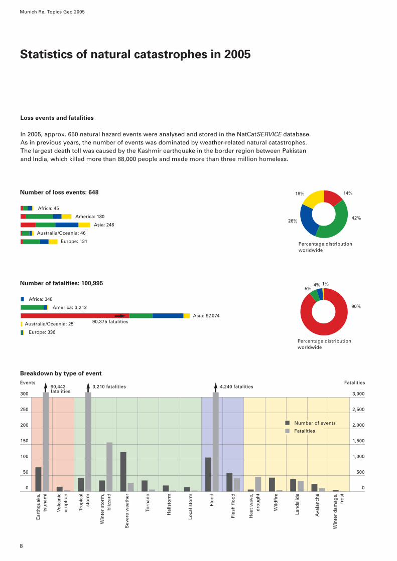
In 2005, approx. 650 natural hazard events were analysed and stored in the NatCatSERVICE database.As in previous years, the number of events was dominated by weather-related natural catastrophes.The largest death toll was caused by the Kashmir earthquake in the border region between Pakistanand India, which killed more than 88,000 people and made more than three million homeless.
Africa: 348
America: 3,212
Asia: 97,074
Australia/Oceania: 25
Europe: 336
90,375 fatalities
Ear
thq
uak
e,ts
un
ami
Volc
anic
eru
pti
on
Tro
pic
alst
orm
Win
ter
sto
rm,
bliz
zard
Sev
ere
wea
ther
Torn
ado
Hai
lsto
rm
Loca
l sto
rm
Flo
od
Flas
h fl
oo
d
Hea
t w
ave,
dro
ug
ht
Wild
fire
Lan
dsl
ide
Ava
lan
che
Win
ter
dam
age,
fro
st
9
Munich Re, Topics Geo 2005 Statistics of natural catastrophes in 2005
Breakdown by type of event
9
8
7
6
5
4
3
2
1
0
US$ 173/83bn US$ 16bn
Earthquake, tsunami, volcanic eruption
Windstorm
Flood
Temperature extremes and mass movement
(e.g. drought, frost, avalanche)
Overall losses (US$ bn)
Insured losses (US$ bn)
Insured losses: US$ 94,379m
87%
3%
4%
7% 3%Overall losses: US$ 212,127m
Africa: 31
America: 173,730
Asia: 21,717
Australia/Oceania: 647
Europe: 16,002 Percentage distributionworldwide
96%
Percentage distributionworldwide
Overall losses and insured losses
2005 was a record year: the most expensive natural catastrophe year in insurance history and forthe world’s economies as a whole. The hurricane losses in North and Middle America and in theCaribbean caused roughly 80% of the overall economic losses and 88% of the insured losses.
Africa: 10
America: 88,062
Asia: 1,060
Australia/Oceania: 372
Europe: 4,875
US$ bn
Ear
thq
uak
e,ts
un
ami
Volc
anic
eru
pti
on
Tro
pic
alst
orm
Win
ter
sto
rm,
bliz
zard
Sev
ere
wea
ther
Torn
ado
Hai
lsto
rm
Loca
l sto
rm
Flo
od
Flas
h fl
oo
d
Hea
t w
ave,
dro
ug
ht
Wild
fire
Lan
dsl
ide
Ava
lan
che
Win
ter
dam
age,
fro
st
In spite of the complete destruction of entire towns and a death toll in the tens of thousands, life must go on. Just a few weeks after the earthquake catastrophe in the border area between Pakistan and India on 8 October,the first merchants opened for business again in the midst of the devastation, although aftershocks could havecaused the ruins to collapse at any time.
10
11
Great natural catastrophes 1950–2005
As in the previous year, great natural catastrophes set newrecords again in 2005, and the trend towards higher and higherlosses continues.
About 650 loss events occurred around the world in 2005.They were duly analysed by Geo Risks Research and storedin NatCatSERVICE®, Munich Re’s natural catastrophe data-base. The number of events registered was in line withthe average of the last ten years. The monetary and human
consequences, however, were extraordinary, since 2005was the costliest natural catastrophe year ever for the insurance industry and one of the three deadliest years in the last quarter of a century.
Six natural hazard events complied with the definition of“great natural catastrophes“ in 2005. They accounted formore than 91,000 deaths (out of a total of 100,000); andgenerated overall losses of US$ 170bn (total: US$ 212bn)and insured losses of US$ 82bn (total: US$ 94bn).
– Floods, India (August)– Hurricane Katrina, USA (August)– Hurricane Rita, USA (September)– Hurricane Stan, Middle America (October)– Earthquake in Pakistan and India (October)– Hurricane Wilma, Mexico, USA, Caribbean (October)(See the insert “World map of natural catastrophes 2005“for the extent of losses from the six great catastrophes.)
Definition“Great natural catastrophes“
In line with definitions used by the United Nations, natural catastrophes are considered “great“ if the affectedregions’ ability to help themselves is clearly over-stretched and supraregional or international assistance is required. As a rule, this is the case when there are thousands of fatalities, when hundreds of thousands ofpeople are made homeless, or when the overall losses –depending on the economic circumstances of the countryconcerned – and/or insured losses reach exceptional orders of magnitude.
The tables allow a comparison of the aggregate loss figures of recent decades. Comparing the last ten yearswith the 1960s makes the increase in natural catas-
trophes particularly clear. This applies both to the numberof events and to the extent of the losses incurred.
Comparison of decades 1950–2005
Decade 1950–1959 1960–1969 1970–1979 1980–1989 1990–1999 Last 10 years
Number of 21 27 47 63 91 57events
Overall losses 48.1 87.5 151.7 247.0 728.8 575.2
Insured losses 1.6 7.1 14.6 29.9 137.7 176.0
Losses in US$ bn (2005 values)
A comparison of the last ten years with the 1960s reveals a dramatic increase.
Munich Re, Topics Geo 2005
12
last 10:60s
2.1
6.6
24.8
Overall losses and insured losses – Absolute values and long-term trends
The chart shows for each year the number of great natural catastrophes, divided up by type of event.
Flood
Temperature extremes (e.g. heatwave, drought, wildfire)
14
12
10
8
6
4
2
0
The chart presents the overall losses and insured losses – adjusted to present values. The trendcurves verify the increase in catastrophe losses since 1950.
Munich Re, Topics Geo 2005 Great natural catastrophes 1950–2005
Over the past year we have continuedour research into the possibility ofidentifying natural hazard trends witheven greater accuracy and certainty.To this end, the data stored in MunichRe’s natural catastrophe database,NatCatSERVICE®, was prepared tomake it more amenable to systematicanalysis. We are pleased to publishthe results of our work for the firsttime in this edition of Topics Geo. ThisNatCatSERVICE® information exam-ines whether there is a discernibletrend towards larger natural catas-trophes, where in the world such atrend may be evident and how it may manifest itself.
Data sources, data preparation, classification
The whole process of evaluatingmacroeconomic losses is subject tosignificant uncertainty and fluctua-tion, as we discussed in detail in topics – Annual Review: Natural Catastrophes 2000.
We used the Munich Re natural catastrophe categories as a basis forour investigation of possible trends(Fig. 1). This seven-level scale – from0, natural event, to 6, great catas-trophe – makes it possible to assigneach loss event to a particular cate-gory, even if the exact extent of theoverall losses are not known or cannot be determined.
Our analysis examined 16,000 naturalcatastrophes in the period between1980 and 2005. Only about a quarterof all events were backed up by reli-able official figures concerning theeconomic losses involved. Since themid-1990s, however, there has been a distinct improvement in the report-ing of overall losses (Fig. 3).
Munich Re’s experts estimated thelosses from the remaining 12,000events on the basis of claims notifica-tions and global comparisons withsimilar events, considering in eachcase the affected national economy.
Two examples of this procedure
Example 1
– Estimate of the overall losses on thebasis of known insured losses usingthe factor of insurance penetration,a value that is known for all marketsand for all the various types ofevent. This method factors in thetype of natural hazard, the region ofa country affected (urban, rural,population density, quality of build-ings), and the classes of insurancebusiness that were affected bylosses. This information is the basisfor a realistic loss estimate (Fig. 2).
Example 2
– If insured losses are not known, asis frequently the case in developingcountries, Munich Re’s loss esti-mate is based on the following par-ameters: type and duration of thenatural catastrophe, region affected(urban, rural, population density,
NatCatSERVICE information
Increasing intensity and costs of natural catastrophes – Is this a long-term trend?2005 broke all negative records. Natural catastrophes have never been so expensive, either for the world’s economies or for the insurance industry. It was also one of the deadliest years of recent decades.
Munich Re’s natural catastrophedatabase NatCatSERVICE® recordsbetween 600 and 900 events everyyear. Depending on their financialand human impact, events are as-signed to one of seven categories –from a simple natural event withvery little economic impact to agreat natural catastrophe. Our eval-uations and statistics do not con-sider pure natural events (catas-trophe category 0).
Munich Re, Topics Geo 2005
14
Fig. 1 Natural catastrophes – Breakdown into seven catastrophe categories
0 Natural event No property damage (e.g. forest fire with no damage to buildings)
1 Small-scale loss event 1–9 fatalities and/or hardly any damage
2 Moderate loss event 10–19 deaths and/or damage to buildings and other property
6 Great natural catastrophe Thousands of fatalities, economy severely affected, extreme insured losses(UN definition)
wealth structure), damage to prop-erty, infrastructure, and public utili-ties, the number of people involved,and the death toll. On the basis ofthis data, an approximation tech-nique then searches for all compar-ative catastrophes in the affectedregion for which there is detailedand reliable information on overalllosses. The events are clusteredand realistic values derived for in-dividual units (e.g. average value of a residential building in a ruralarea). In this way, the event can be assigned to a certain category of loss.
In order to determine the extent ofthe loss, all events were assigned toone of seven categories of natural catastrophe. Catastrophe category 0was disregarded for the purposes ofour analysis, as it is used for naturalevents which have little or no eco-nomic impact. The remaining events
were divided into three main cate-gories:
– Small-scale and moderate lossevents (categories 1 and 2)
– Severe and major catastrophes (categories 3 and 4)
– Devastating and great natural catas-trophes (categories 5 and 6)
The analysis
– There were hardly any noticeabledifferences in the percentage break-down of the types of event acrossthe three main categories. The ex-ceptions to this are earthquakes andvolcanic eruptions. The proportionof windstorms in the three maingroups is in fact absolutely identi-cal. Overall, weather-related naturalcatastrophes dominated with ashare of over 85% in all catastrophecategories (Fig. 4).
%
35
30
25
20
15
10
51980 1985 1990 1995 2000 2005
Fig. 3 Percentages of natural catastrophes with very good reporting of economic losses from 1980 to 2005
Fig. 2 Example of a loss estimate: Hurricane Ivan, USA, 2004
Insured losses Estimated direct (US$ m) overall losses (US$ m)
Insured property damage– USA (average loss US$ 11,500, 7,110 10,000 *
especially Florida and Alabama, approx. 500 000 claims notifications)
– offshore facilities 3,000 3,000 **– under the National Flood 1,000 2,000 ***
Insurance Program
Damage to infrastructure andsupply facilities 3,000
approx. 12,000 approx. 18,000
* approx. 70% insurance penetration.** 100% insured, no further effect on the overall losses.*** 50–60% insurance penetration.
15
Munich Re, Topics Geo 2005 NatCatSERVICE information
As a rule, the figures for direct economic losses are stored in theNatCatSERVICE database. Theseare immediately visible and count-able losses, e.g. damage to homesand vehicles. The replacementcosts including the costs of remov-ing the damage are estimated.
Precise loss analyses and reportsare compiled by governments and other official offices only after significant natural catastrophes.Since the mid-1990s, the quality of reporting has risen perceptibly.
– If one considers the number ofevents from 1980 up to the presentday in their respective categories, it can be seen that the proportion of catastrophes in category 1 has diminished while there has been asignificant increase in categories 2 and 3 (Fig. 5).
– A similar breakdown by continentshows that Asia – the continent withthe most towns and conurbations –clearly dominates in terms of thenumber of events. Asia experienced4,500 events, 70% of which were so-called “small loss events“. At thesame time, however, Asia also ex-perienced the greatest number ofdevastating and great natural catas-trophes (225 events).
– Asia was also hardest hit in termsof the number of fatalities (800,000).Almost 90% of these fatalities werecaused by events in catastrophecategories 5 and 6 (devastating andgreat catastrophes).
A comparison of Europe and NorthAmerica (USA and Canada) showsthat the two continents were affectedby about the same number of naturalcatastrophes (Fig. 6). However, whileEurope was hit primarily by smallevents, North America had to con-tend with a greater number of severeand great natural catastrophes (cate-gories 3–6). This trend is also re-flected in the loss figures: overalllosses in North America were almostthree times as high as those in
Europe and insured losses about fourtimes as high. In absolute terms,more people died in Europe, but thiscan be largely attributed to a singleevent: the 2003 heatwave, which af-fected the whole continent. The finaldeath toll was more than 35,000.
Earthquake, tsunami, volcanic eruption
Windstorm
Flood
Temperature extremes (e.g. heatwave, wildfire), mass movement (e.g. avalanche, landslide)
Fig. 4 Percentage distribution of events (1980–2005) by catastrophe category and type of natural event
The breakdown of natural hazardlosses into natural catastrophe cat-egories reveals an increase in themoderate loss events (category 2)and severe natural catastrophes(category 3). There is a downwardtrend as far as small-scale lossevents are concerned.
900
800
700
600
500
400
300
200
100
0
Fig. 5 Number of events per year (1980–2005) broken down into catastrophe categories
1980 1985 1990 1995 2000 2005
Small-scale loss events
Moderate loss events
Severe catastrophes
Major catastrophes
Devastating catastrophes
Great natural catastrophes
Munich Re, Topics Geo 2005 NatCatSERVICE information
16
Small-scale and moderate loss events(categories 1 and 2)
Severe and major catastrophes(categories 3 and 4)
Devastating and great natural catastrophes(categories 5 and 6)
Categories 1–6
16%
42%
14%
28%
7%
42%
17%
34%
18%
42%
12%
28%
Results
The categorisation of natural hazardevents into a seven-stage catastrophescale marked an important step for-ward in this trend analysis. Assigningevents to size categories makes itpossible to analyse trends more ac-curately and reliably.
This reveals that the devastating andgreat catastrophes in categories 5and 6 are responsible for most of thelosses and deaths, causing 86% of all fatalities, 86% of overall losses,and 80% of insured losses. However,these categories account for only 3%of all events. The small loss eventsstill predominate, but there is a dis-tinct trend towards more intensive
and costlier natural catastrophes. Thequality of reporting by official insti-tutions on the economic impact ofnatural hazard events has improvedconsiderably in recent years. This isvery good news, as the powers-that-be can only implement appropriateand effective measures to tackle, mitigate, or prevent losses if theyhave reliable information on the trueextent of natural catastrophes.
Summary
Countless measures will have to betaken around the world in order tosoften the effects of a persistent trendtowards ever-larger and more cata-strophic natural events. Knowledgemust be imparted and awareness
Fig. 6 Natural catastrophes 1980–2005 broken down into catastrophe categories – A comparison between Europe and North America
Small-scale and moderate loss events (categories 1 and 2)
Severe and major catastrophes(categories 3 and 4)
Devastating and great naturalcatastrophes (categories 5 and 6)
17
Munich Re, Topics Geo 2005 NatCatSERVICE information
Europe
North America
Number of events
0 1,000 2,000 3,000 4,000 5,000
Europe
North America
Fatalities
0 20,000 40,000 60,000 80,000 100,000
Europe
North America
Overall losses (US$ bn)
0 180 360 540 720 900
Europe
North America
Insured losses (US$ bn)
0 80 160 240 320 400
sharpened. For the people at risk it isquite literally vital to know what to do before an imminent catastrophearrives and how to react when itstrikes. Insurance cover remains themost effective way of protectingproperty and belongings. People inthe poorer regions of the world couldacquire such protection through so-called microinsurance programmes.Munich Re, the World Bank and localinsurers already offer this option ofaffordable basic cover in some coun-tries of the world – to the great bene-fit of the people concerned.
Angelika Wirtz
The 2005 hurricane season broke all records – with 27 tropicalcyclones in the Atlantic. Hurricane Wilma was the strongesthurricane ever recorded, Katrina the most expensive. Thisphoto shows the remains of a souvenir centre in Biloxi. Katrinaalmost completely destroyed this tourist attraction with itssculptures on the façade.
18
19
Munich Re, Topics Geo 2005
20
New meteorological records and unusual tracks
An account of the 2005 hurricane season is virtually a listof unusual events, many of which have never been ob-served before – at least, not since recordings of theweather in the Atlantic have been made on a systematicbasis.
– Highly active start to the season· Seven tropical cyclones occur in June and July.· Previous to that, a maximum of five such storms had
been observed before the end of July (1887, 1933, 1936,1959, 1966, 1995, 1997).
– Peak intensity values· Three of the ten strongest hurricanes ever recorded occurred in 2005.
· Hurricane Wilma had the lowest central pressure everrecorded in the Atlantic (882 hPa) and hence, in allprobability, the highest wind speeds (Fig. 1).
– Record number of tropical cyclones· The 27 named tropical cyclones in 2005 (15 of which
reached hurricane force) broke all past records: 21tropical storms in 1933 and 12 hurricanes in 1969.
· For the first time ever, the list of 21 names chosen bythe World Meteorological Organisation (WMO) was not long enough. The last six cyclones were thereforenamed after the first six letters in the Greek alphabet:Alpha, Beta, Gamma, Delta, Epsilon, and Zeta.
– New areas affected: Europe and Africa· At the beginning of October, Hurricane Vince formed
near the island of Madeira, the most easterly andnortherly tropical cyclone ever to occur in the Atlantic.Its track ran northeast towards the European mainland.Vince weakened and reached the Spanish coast nearHuelva as a tropical depression on 11 October.
Hurricane season 2005: Time to rethink
With insured losses of US$ 30bn from tropical cyclones, 2004 was consid-ered an exceptional year. However, this new record did not last long andwas already broken in 2005. The most active tropical cyclone season sincerecordings began in 1851 is costing the private insurance industry morethan US$ 80bn.
Fig. 1 Tracks of all tropical cyclones in the North Atlantic in 2005
Fig. 2 Tropical cyclones in the Gulf of Mexico and the Caribbean
New York
New Orleans
Miami
Mexico City
Lisbon
New York
New Orleans
Miami
Mexico City
Arlene
Cindy
Katrina
GertBret
Gamma
Beta
Emily Dennis
Alpha
WilmaTammy
Stan
Wind speeds in km/h(categories on the Saffir-Simpson Hurricane Scale)
· At te end of November, Tropical Storm Delta passedover the Canaries and continued towards the Moroccancoast. It was the first tropical cyclone ever in this region.
– Last hurricane of the season in December· According to the US National Hurricane Center, the
Atlantic hurricane season lasts from the beginning ofJune to the end of November; but when Epsilon devel-oped into a Category 1 hurricane, it was already De-cember. The 2005 season finally came to an end withTropical Cyclone Zeta at the end of December.
· There have only been four other years since 1851 inwhich a tropical cyclone strengthened to a hurricane in December: 1887, 1925, 1954, 1984.
The most significant events of the 2005 hurricane season
Katrina – The costliest windstorm of all time
Hurricane Katrina, which developed out of a low-pressurevortex over the Bahamas on 23 August and made land-fall on the evening of 25 August as a Category 1 hurricanenear Miami, was the 11th tropical cyclone of the season. It generated insured losses in southern Florida amountingto roughly US$ 1bn.
In the days that followed, Katrina moved over the easternpart of the Gulf of Mexico with a rapid increase in inten-sity. On 28 August, it was already a Category 5 hurricaneover those areas where the water temperature was cur-rently 1–3°C above the long-term average, with peak gustsof around 340 km/h. Katrina maintained this strength as
it crossed the oilfields off the coast of Louisiana and Mississippi. On 29 August, shortly before hitting the main-land some 50 km east of New Orleans, it weakened to aCategory 3 windstorm.
The wind and storm surge damage was horrendous: partsof New Orleans were flooded when levees along LakePontchartrain and artificial drainage canals failed; manyoffshore plants in the Gulf of Mexico were destroyed;more than 1,300 people were killed. The direct overalllosses are at least US$ 125bn. It will probably cost the pri-vate insurance industry some US$ 45bn (as at February2006), making it the most expensive loss ever from onesingle event. In addition, there are also insured floodclaims from the National Flood Insurance Program (NFIP),currently estimated to be approaching the two-digit billiondollar range.
The full extent of the loss was still not clear even at thebeginning of 2006. The scale of the insured losses and theexperience from the years 2004 and 2005 suggest that thiskind of event is no longer a meteorological anomaly. Theinsurance industry is therefore giving intense thought tothe question of how the hurricane hazard must be evalu-ated in the future. The focus of the current scientific de-bate is on the effects of the natural climate oscillation inthe North Atlantic and the impact of global warming onthe frequency and intensity of tropical cyclones.
A further question is whether the knowledge gained fromKatrina makes it necessary to re-analyse the loss accumu-lation levels of other perils (e.g. earthquakes) and otherregions and countries.
Fig. 3 The ten hurricanes with the lowest central pressures
Year Name Lowest Sea areapressure (HPa)
2005 Wilma 882 Caribbean
1988 Gilbert 888 Caribbean
1935 Labor Day Hurricane 892 Florida Keys
2005 Rita 897 Gulf of Mexico
1980 Allen 899 Caribbean
2005 Katrina 902 Gulf of Mexico
1998 Mitch 905 Offshore Honduras
1969 Camille 905 Gulf of Mexico
2004 Ivan 910 Caribbean
1955 Janet 914 Caribbean
Fig. 4 Tropical cyclones and hurricanes in the Atlantic in 2005
6
5
4
3
2
1
0
Number
June July Aug. Sept. Oct. Nov. Dec.
Munich Re, Topics Geo 2005 Hurricane season 2005
22
This relates to the following aspects:
– Dimensions of the storm surgeThe storm surge triggered by Katrina hit the states ofLouisiana, Mississippi, and Alabama along a 150-kmstretch of coast. The flood wave, which was 10 m high inparts, was able to penetrate several hundred metres in-land and in some cases, where the topography allowed,as much as a kilometre. In those areas where the hinter-land is traversed by a network of natural water courses(bayous), wind set-up drove the storm surge distancesof several kilometres.
This resulted in areas being flooded that were outsidethe 500-year zone (areas which, on a long-term average,are flooded less than once in 500 years) on the floodhazard map used by the Federal Emergency Manage-ment Agency (FEMA). The majority of buildings in thisregion were total losses. The restoration of risks withbusiness interruption cover is likely to take time as theinfrastructure (roads, bridges, utility lines) was alsodamaged or destroyed.
– Partial flooding of New Orleans following levee failuresThe insurance industry must not only reconsider thestructural engineering methods and design criteria forthe levee protection around Lake Pontchartrain but alsothe accumulation assessment of other well-known lossscenarios. In spite of the warnings from scientists anddisaster management organisations, the insurance in-dustry underestimated New Orleans’ exposure to stormsurges and floods.
– Inordinate increase in insured losses as a result ofmacroeconomic influencesAfter the 2004 hurricanes in Florida, an attempt wasmade to explain the often underestimated losses by citing such effects as demand surge and major catas-trophe surcharges. Following Katrina, many insurersfound that the losses they finally had to pay were oftenfar higher than their initial forecast. This was due to thefact that the scale of a major catastrophe is enhanced bythe shortage of resources (construction materials andworkers needed for reconstruction work) and the limitedavailability of infrastructure installations. A number offundamental questions emerge: Do the methods usedhitherto in the analysis of accumulation loss potentialsneed to be supplemented by appropriate components?Can past experience be applied to future megacatas-trophes in the form of a quasilinear approximation orare new approaches needed here too?
– Differentiation between wind and water losses in wind-storm policiesThe standard US policies for the windstorm hazard basic-ally exclude flood damage to residential buildings andcontents. The same applies to small commercial risks aswell. Owners of residential and small commercial build-ings in the USA can insure their property against floodsand other water-related causes of loss that are not covered by private insurance through the National FloodInsurance Program (NFIP). Accordingly, flood damage is explicitly included in the scope of cover provided bythe NFIP, and this has always been acknowledged in theloss adjustment process up to now. Building owners
Abb. 6 Wind field of Hurricane KatrinaAbb. 5 Track of Hurricane Katrina
without an additional NFIP policy carried the flood riskthemselves. Katrina has triggered an intense discussionon this approach in both legal and political circles. Theoutcome of this debate will show whether insurers,which had not included a premium for flood damage intheir policies, can count on the distinction between windand water covers being maintained or whether, and if so how, the legal situation will change.
– High death toll from weather-related natural catas-trophes in industrial countries tooThe death toll from windstorm and flood events in industrial countries has been falling continuously in recent decades. This is due to the success of improvedearly-warning systems and resolute evacuation meas-ures, particularly in the United States. Since the worstnatural catastrophe in US history – the Galveston hurri-cane in 1,900 with a death toll exceeding 8,000 – thenumber of people killed in hurricanes has been steadilydecreasing. It was not until Hurricane Katrina that thethreshold of 1,000 deaths was surpassed for the firsttime since 1928 (Fig 7).
Although the large number of Katrina victims cannot betaken as an indication of what will happen in futureevents, it does show that weather-related events can haveserious human repercussions even in industrial countriesif there is a coincidence of unfavourable factors. For theinsurance industry this means additional claims costsabove all in life, personal accident, and workers’ compen-sation and an increase in the overall accumulation fromlife and non-life policies.
Hurricane Rita – A close call for Houston, Texas
Hardly a month had passed after Katrina when Ritaformed in the southern part of the Bahamas as the secondCategory 5 hurricane of the season. It had a central pres-sure of 897 hPa, one of the lowest readings ever for aNorth Atlantic hurricane (Fig. 3). Some of the predictionmodels used by the National Hurricane Center in Miami(Florida) indicated temporarily that Rita would make land-fall near Galveston/Houston (Texas) with a force of 4 to 5.This scenario would have meant an even more seriouscase of accumulation for the insurance industry, with in-sured losses that would have far surpassed those causedby Katrina because the insured values in Galveston/Hous-ton (residential buildings, contents, and commercial andindustrial risks) were about twice as high as in the areasaffected by Katrina (even including New Orleans). Also,given a Category 5 landfall, the vulnerability of buildingsand contents would have been much higher again, as itincreases exponentially with wind speed.
Fig. 7 Tropical cyclones in the United States with more than 100 fatalities
Year Region Number of fatalities
1856 LA, Last Island 400
1875 TX 176
1881 GA, SC 700
1886 TX, Indianola 150
1893 LA, Cheniere Caminada 1,250
1893 GA, SC 1,500
1896 FL, GA, SC 130
1898 GA, SC, NC 179
1900 TX, Galveston 8,000
1906 FL (southeast) 164
1906 134
1909 LA, Grand Isle 350
1915 LA, New Orleans 275
1915 TX, Galveston 275
1919 FL, Keys, TX (south) 287
1926 FL, Miami, MS, AL, Pensacola 372
1928 FL, Lake Okeechobee 2,500
1935 FL, Keys 408
1938 Northeast coast 600
1955 Hurricane Diane, east coast 184
1957 Hurricane Audrey, LA (southwest), TX (north) 400
1969 Hurricane Camille, MS, FL, TN, LA, VA 256
1972 Hurricane Agnes, FL, northeast coast 122
2005 Hurricane Katrina, AL, FL, LA, MS 1,322
Munich Re, Topics Geo 2005 Hurricane season 2005
24
However, when Rita made landfall on 24 September nearSabine Pass in the border area between Texas andLouisiana, it was a Category 3 hurricane with peak gustsof 250 km/h. This near miss made many insurers suddenlyaware that they had seriously underestimated the loss potential in the Gulf of Mexico, both in terms of the lossesfrom one single event and in terms of the accumulationfrom several moderate to major hurricanes hitting coastalareas with high concentrations of values within a singleyear.
The insured loss from Rita is estimated to be around US$ 5bn from residential, commercial, and industrial risksin the United States and a further sum of up to US$ 6bnfrom offshore energy plants in the Gulf of Mexico (as atFebruary 2006). In the case of Rita too, the overall lossamount was increased by a storm surge in the borderarea between Texas and Louisiana.
Hurricane Stan – A death toll exceeding 1,500 likely inMiddle America
One of the worst human catastrophes in the history ofMiddle America was triggered in 2005 by Hurricane Stan.The storm developed on 1 October some 200 km east ofthe Mexican peninsula of Yucatan, crossing it the day after as a tropical storm and intensifying to a Category 1hurricane over the Bay of Campeche. Stan reached theMexican mainland for the second time at Veracruz andgradually weakened as it moved southwest over largeparts of the country. Although its track was restricted toMexico, the resulting torrential rain had a much greater
impact in other Middle American countries. More than840 people were killed by floods and landslides in El Salvador, Guatemala, Nicaragua, and Mexico, whilst 800are still listed as missing in Guatemala following a land-slide.
Hurricane Wilma – Lowest central pressure measuredsince 1851
The season’s 21st tropical cyclone and 13th hurricane inthe North Atlantic was an event of meteorological su-perlatives, causing record losses in Mexico and high in-sured losses in Florida. On 19 October, over the warmCaribbean water, Wilma had a central pressure of 882hPa, lower than any other recorded in a hurricane. With a drop in pressure of 88 hPa in 15 hours (including 53 hPain just 4 hours) this storm counts as a “meteorologicalbomb“ on account of its explosive intensification.
For the first time since Hurricane Gilbert in 1988, thetourist centres on the Mexican peninsula of Yucatan andthe offshore island of Cozumel were hit by a major hurri-cane. When it made landfall in Mexico on 21 October,Wilma was a Category 4 hurricane, with average windspeeds of 225 km/h. As the region’s infrastructure hadbeen undergoing massive development in recent years,the property values were concentrated in the immediatevicinity of the coast (many of them with business inter-ruption covers). The resulting insured loss will come tosome US$ 2bn (as at February 2006), making it the mostexpensive loss ever for the insurance industry from onesingle event in Mexico.
Fig. 8 Track of Hurricane Rita Fig. 9 Wind field of Hurricane Rita
Washington
New York
Dallas
HoustonNew Orleans
Miami
Santo Domingo
Mexico City
Miami
Houston New OrleansSt. Louis
Wind speeds in km/h(categories on the Saffir-Simpson Hurricane Scale)
Wind speeds in km/h(categories on the Saffir-Simpson Hurricane Scale)
Source: NOAA, HRD, Miami
25
Munich Re, Topics Geo 2005 Hurricane season 2005
After remaining more or less stationary over Yucatan forseveral hours, the low-pressure vortex weakened and, on23 October, slowly shifted northeast towards Florida. Thenext day, Wilma crossed over the west coast of Florida asa Category 3 hurricane near Cape Romano. It moved for-wards at high speed and after less than five hours sweptout into the open Atlantic again, north of Palm Beach, as a Category 2 hurricane.
The insured market loss in Florida is currently estimatedto be US$ 8.5bn, an amount similar to that generated byboth Charley and Ivan in 2004.
Hurricane activity – Climatic setting
Recent findings of climate research confirm that the cy-clone hazard in the North Atlantic has increased markedlysince the mid-1990s. Cyclones there have become moreintense, reaching very high wind speeds for longer andlonger periods.
The increase in intensity is associated with a global increasein sea surface temperatures, averaging approx. 0.5°C dur-ing the summer season in all tropical ocean regions since1970. A comparison of the recorded trend and computersimulations reveals that this warming can only be the re-sult of anthropogenic climate change. Globally, the annualnumber of strong storms (categories 4 and 5 on the Saffir-Simpson Scale) has more than doubled from around 8 atthe beginning of the 1970s to 18 in the period 2000–2004.An average of about 80 cyclones form every year.
In the North Atlantic, it is not only the intensity that is in-creasing but also the frequency. The prime factor for thisis the natural cycle of sea surface temperatures. Therecord number of cyclones in the 2005 season coincideswith what current data indicates to be the highest meanannual temperature measured in the North Atlantic sincerecordings began in 1880.
This is due to the simultaneous influence of two processeswhich determine sea temperatures and hurricane activity:the natural climate oscillation and the linear warming pro-cess caused by anthropogenic climate change.
The natural climate oscillation involves phases of excep-tionally warm and exceptionally cool sea surface tem-peratures, each lasting several decades. The margin of deviation is roughly 0.5°C, with an oscillation period inthe 20th century of about 65 years. This oscillation isdriven by large-scale ocean currents. Warm phases gen-erate distinctly more hurricanes and a higher intensity,whereas cold phases have the opposite effect. Since themid-1990s, we have been in a warm phase which will con-tinue for a number of years, if not decades. In this phase,there have been 4.1 major (Category 3–5) hurricanes on ayearly average, compared with only 1.5 in the last coldphase – an increase of about 170%. Needless to say, thedefinitive average level of activity can only be calculatedwhen the current warm phase has ended.
At the same time, the natural oscillation between thesephases is being intensified by a long-term warmingprocess so that sea surface temperature and hurricane
Fig. 10 Tracks of Hurricanes Stan and Wilma
St. Louis Washington
New York
Dallas
HoustonNew Orleans
Miami
Santo Domingo
Guatemala City
Mexico City
Wilma
Stan
The tourist centres on the Mex-ican peninsula of Yucatan and theoffshore island of Cozumel werebadly hit by Hurricane Wilma. Thehard gypsum panels mounted onthe steel-frame structure of this
apartment block in Cozumel werenot sturdy enough to withstandthe persistent high wind speeds.
Wind speeds in km/h(categories on the Saffir-Simpson Hurricane Scale)
activity are increasing from warm phase to warm phase.The rise in the number of strong hurricanes per year from2.6 to 4.1 from the previous warm phase to the currentwarm phase corresponds to an increase of around 60%.There are strong indications that climate change isresponsible for this long-term warming.
The change in the level of activity also influences thenumber of landfalls and hence the losses incurred. In thecase of major hurricanes, the annual average number oflandfalls in the United States has increased by about230% from 0.3 to 1.0 compared with the last cold phase(approx. 1971–1994) and by about 70% from 0.6 to 1.0compared with the last warm phase (approx. 1926–1970).
What conclusions can the insurance industry draw fromthese observations? We must expect a different loss dis-tribution in the current warm phase than in the years be-fore. As the models have a loss distribution based usuallyon all loss events since 1900 and make no differentiationbetween the various phases, it is inevitable that the cur-rent loss level is underestimated, because the loss distri-bution of the current warm phase is likely to deviate sig-nificantly from that of the entire period since 1900. This isborne out by a comparison of hurricane intensity distribu-tions for the whole period 1900–2005 and the current
warm phase (1995–2005). Category 4 hurricanes accountfor 14% of all hurricanes since 1900 and Category 5 hurri-canes 6%, compared with 21% and 10% respectively inthe current warm phase distribution. Weaker hurricanes(categories 1 and 2) have been less frequent in the currentphase. In Munich Re’s analyses, the annual loss ex-pectancy increases distinctly if the loss distribution of thecurrent warm phase is taken as a basis rather than onethat does not consider the different phases.
To sum up, the higher frequencies and intensities of hurri-canes in the North Atlantic are almost certainly due to thecombined impact of an unfavourable natural climatephase and anthropogenic climate change. Our analysessuggest that the natural climate oscillation is responsiblefor about two-thirds of the overall effect and global warm-ing about one-third. The effect of the natural climate oscil-lation will weaken in a few years or decades and then gointo reverse, whilst global warming must be expected toaccelerate.
The storm surge wave and highwind speeds of Hurricane Katrinawrenched the floating casinosfrom their moorings on the Gulf
Coast of Mississippi and carriedthem several hundred metres inland.
27
Munich Re, Topics Geo 2005 Hurricane season 2005
Hurricane season 2005
Name Date Maximum Maximum Affected Fatalities Estimated Estimatedcategory on wind speeds areas overall insuredSaffir-Simpson losses losses Scale (US$ m) (US$ m)
Tropical Storm Arlene 8–13 June 110 km/h USA: FL 1
Tropical Storm Bret 28–29 June 65 km/h Mexico 2 10
Hurricane Cindy 3–7 July 1 120 km/h Mexico. 3 250 160USA: AL, LA, MS, GA
Hurricane Dennis 5–13 July 4 240 km/h Jamaica. Haiti. Cuba.USA: FL, AL, MS, GA 76 3,100 1,200
Hurricane Emily 11–21 July 4 245 km/h Caribbean. Mexico 13 400 250
Tropical Storm Franklin 21–29 July 110 km/h Bahamas
Tropical Storm Gert 23–25 July 75 km/h Mexico
Tropical Storm Harvey 2–8 Aug 105 km/h Bermuda
Hurricane Irene 4–18 Aug 2 175 km/h
Tropical Storm Jose 22–23 Aug 80 km/h Mexico 6
Hurricane Katrina 23–31 Aug 5 280 km/h USA: AL, FL, LA, MS 1,322 125,000 60,000
Hurricane Rita 18–26 Sept 5 280 km/h USA: FL, LA, TX, MS 10 16,000 11,000
Hurricane Stan 1–5 Oct 1 130 km/h Mexico. Guatemala > 840 3,000 100
Tropical Storm Tammy 5–6 Oct 80 km/h USA: FL, GA
Hurricane Vince 9–11 Oct 1 120 km/h Portugal. Spain
Hurricane Wilma 15–25 Oct 5 280 km/h Mexico. USA: FL 38 18,000 10,500
Tropical Storm Alpha 22–24 Oct 80 km/h Dominican Republic. Haiti 28
Hurricane Beta 27–31 Oct 3 185 km/h Nicaragua. Colombia. 10Honduras
Tropical Storm Gamma 18–21 Nov 80 km/h Honduras. Belize 37
Tropical Storm Delta 23–28 Nov 110 km/h Spain: Canary Islands. 20 375Morocco
Hurricane Epsilon 29 Nov–8 Dec 1 140 km/h
Tropical Storm Zeta 30 Dec 2005 100 km/h–6 Jan 2006
Source: NHC and MRNatCatSERVICE ®.
Munich Re, Topics Geo 2005 Hurricane season 2005
28
Models require adjusting
The extremely active windstorm years of 2004 and 2005,tropical cyclones in regions where such events were notpreviously expected, and new scientific findings on natur-al climate oscillations and the effect of climate change onthe hurricane hazard make it absolutely essential to revisethe hurricane simulation models.
The central issue is the risk of change and its repercus-sions with regard to risk measurement (e.g. accumulationexposure and pricing). Because one thing is clear: short-term measures will probably be able to contend with thenew hazard situation for no more than a few years. Themore realistic approach would be for science and the insurance industry to join forces in a longer-term processin order to analyse the new conditions and find adequatesolutions.
Munich Re had already adjusted its methods and modelsin the past with a view to keeping them in line with cur-rent scientific knowledge. However, it has made furtheradjustments in its frequency and intensity assumptions inthe wake of Katrina and other major hurricane events.Loss-aggravating effects in complex large and extremelylarge losses have also been accounted for in the riskanalysis. The loss distributions with which the hurricanerisk is evaluated have therefore changed radically.
These new distributions have an impact on many pro-cesses – pricing, the calculation of the required risk capit-al, and profit-oriented portfolio management. The adjust-ments that need to be made will vary from insurer toinsurer, but they will be substantial in every case.
Dr. Eberhard Faust, Ernst Rauch
29
The windward façade of this high-rise in Fort Lauderdale,Florida was damaged by wind-blown objects and building debris during Hurricane Wilma.
30
31
Kashmir and parts of North Pakistan were devastated whenthe magnitude 7.6 earthquake struck at 8.52 local time on 8 October 2005. The tremors lasted for 50 seconds, causingthe collapse of some 200,000 houses and razing entiretowns and villages to the ground. With 88,000 fatalities,approx. 200,000 injured, and more than three millionhomeless, the Kashmir quake ranks second only to the De-cember 2004 tsunami as the worst natural catastrophe ofthe past decade. A generation of young people was almostcompletely wiped out when hundreds of schools collapsed.
Inadequate construction methods have devastatingeffects
Several million people live in the regions affected – somein cities like Muzaffarabad and Balakot, but many more inthe innumerable small mountain villages and houses thatcling to the steep flanks of the valleys. The houses of therural population are simple, made of irregular bricks andpoor-quality mortar. The stone walls caved in during thequake, burying the inhabitants under heavy roofs. Largeparts of the infrastructure were destroyed by hundreds oflandslides. Transport helicopters were needed to carry theheavy clearance and rescue equipment into the destroyedtowns and villages. Many areas could not be reached onthe ground and had to be supplied from the air.
In spite of enormous efforts on the part of local authorities,the military, and international aid organisations, the workhad to concentrate initially on the larger towns. Here toothe construction of the buildings was not commensuratewith the hazard to which they were exposed. The picturewas the same in many districts. The few houses that didnot collapse were made uninhabitable, and will remain so for a long time to come. Although the majority of publicbuildings (schools, hospitals, public offices) were rein-forced concrete frame structures, both the material and the construction work were of inadequate quality. Many of the concrete columns buckled, and the heavy concreteceilings gave way.
At a distance of 25 km from the epicentre, more than 50%of the buildings were badly damaged. In Islamabad, how-ever, there were hardly any notable losses – apart fromthe collapse of an apartment complex.
Further quakes to be expected in the Himalayas
The epicentre was a little less than 100 km north of Islam-abad in the mountainous Kashmir region of Pakistan. Thefracture face stretched over a length of 90 km and reachedinto the Indian part of Kashmir. The whole region had longbeen classed as highly exposed to earthquake. The hypo-centre was at the western end of a fault system running adistance of almost 2,000 km along the Himalayas. This fracture was caused by the Indian subcontinent driftingnorthwards and colliding with Eurasia and is frequently thelocation of extreme earthquakes with magnitudes of 8 andabove. The last major quake in the northwest of India andthe Kashmir region was in 1555. Since then, an enormousamount of seismic energy has built up, of which no morethan 10–20% was released in this most recent quake. Seis-mologists expect even more destructive earthquakes to occur in future along the southern edge of the Himalayas.
Earthquake report
Kashmir quake claims 88,000 lives
The earth only shook for 50 seconds on the morning of 8 October 2005. But that was enough to make hundreds of schools in Kashmir collapse,obliterating a whole generation in many places.
Munich Re, Topics Geo 2005
Clean-up operations are making slowprogress, and, just months after thecatastrophe, it is still too early tothink of rebuilding. Many years willpass before normal living conditionsare restored in the disaster region.
Munich Re, Topics Geo 2005 Earthquake report
32
Microinsurances can help
An antagonism only at first sight: one of the biggest natur-al catastrophes in recent decades was practically a non-event for the insurance industry. In Pakistan, most of therisks covered by earthquake insurance are large industrialplants. Since the region affected is very rural, the insuredloss was low. As in the earthquakes that hit India in 2001(20,000 deaths) and Iran in 2003 (26,000) and the tsunamiof 2004 (more than 200,000), it was the poor sections ofthe population that had the most fatalities to mourn. Thosewho survived the quake were left with nothing. Hundredsof thousands have to endure the fierce winter in tents thatwere pitched on or immediately next to the remains oftheir ruined houses. Although an international aid confer-ence promised funds of roughly €5bn, the question iswhether earthquake-resistant rebuilding will be possiblegiven the time constraints and the adverse geographicalconditions.
The people in the poorer regions of the world must begiven assistance proactively and not only when a catas-trophe occurs. The insurance industry can contribute tothis process and provide affordable insurance solutions.The microinsurance sector, for example, has an importantrole to play in the fight against poverty, and a successfulstart has already been made in the agricultural sector andin life and health insurance. It is possible to extend theseconcepts to natural hazard covers as well. Better insur-ance protection can be attained – in cooperation with de-velopment banks, for example – by setting up insurancepools for residential buildings, as happened after the 1999earthquake in Turkey, for instance. Supported by buildingcodes and education measures, this helps bring about the risk minimisation that is so urgently required.
Alexander Allmann
Probable maximum intensity(Modified Mercalli IntensityScale) with an exceedance prob-ability of 10% in 50 years (cor-responding to a return period of475 years) given average subsoilconditions.
Earthquakes
MM ≤ V
MM VI
MM VII
MM VIII
MM ≥ IX
Epicentre
Aftershocks
8 October 2005
10 October 2005
12 October 2005
14 October 2005
16 October 2005
Seismic hazard map of Pakistan and North India and the location of the epicentre
India
Pakistan
India/Pakistan
0 125 250 500 km
Muzaffarabad
Faisalabad
Hyderabad
Karachi
LahorePakistan
Islamabad
Muzaffarabad
Islamabad
★
0 25 50 100 km
India/Pakistan
★
Source: Munich Re, World Map of Natural Hazards
★
33
Munich Re, Topics Geo 2005 Earthquake report
Hundreds of thousands are home-less and must spend the harshwinter at tent camps in the val-leys. Although access to cleanwater and food is largely assured,diseases are spreading rapidly,and particularly colds. Many ofthe tents are not winterproof andwarm winter clothes are in shortsupply.
The ruins of collapsed houses pile up wherever one looks. Togather building materials fromthe piles of debris, people usesledgehammers or even theirbare hands. Given the wintry conditions, the clean-up opera-tions are making slow progress,and so far there has been littlechance of anything being re-stored.
Many districts present a pictureof total destruction, with everysingle building having collapsed.Low hills like the one in the background appear to have beenhit particularly hard, probably because topographical focusingeffects amplified the tremorsduring the earthquake. In manycases, the buildings slid down the hill as the simple foundationswere not able to withstand theground motion.
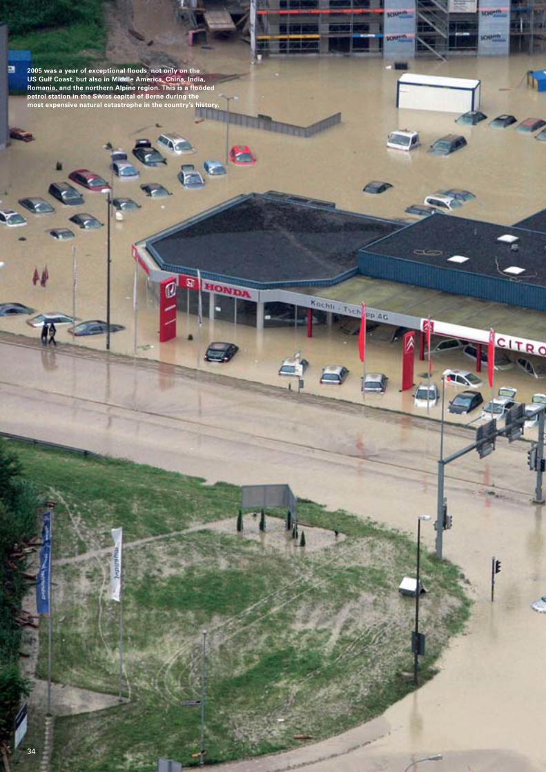
2005 was a year of exceptional floods, not only on the US Gulf Coast, but also in Middle America, China, India, Romania, and the northern Alpine region. This is a floodedpetrol station in the Swiss capital of Berne during the most expensive natural catastrophe in the country’s history.
34
35
Munich Re, Topics Geo 2005
36
The events as they unfolded
On 20 August, a low-pressure system (Norbert) formedover southern France. It slowly made its way eastwardsacross the Gulf of Genoa, picking up substantial quantitiesof moisture on its southern flank along the way. As low-pressure vortices in the northern hemisphere always rotate in an anticlockwise direction, the moist air first im-pinged on the eastern end of the southern Alps and then,following further rotation, advanced towards the moun-tains from the north. The air cooled as it was forced up-wards and heavy rainfall ensued in the entire region northof the main Alpine ridge – in places there was more than200 mm rain in 24 hours and over 300 mm in 72 hours,setting new rainfall records at many places in this area.
Perilous slopes
Torrential rain has a much more devastating effect in themountains than in flat terrain. The water flows down themountainside at a much faster pace and causes signifi-cant erosion of slopes and channels. Infiltrating water can trigger landslides, which then deposit easily erodablematerial in the river valleys. This may lead to dangerousand destructive debris flows – a mixture of water andsolid materials. In such circumstances, a mountain streamcan be transformed from a babbling brook into a ragingtorrent in the space of just a few minutes, leaving little orno time for effective protection measures. It is thereforevitally important to have accurate forecasts of the ex-pected rainfall. However, this is particularly difficult inmountain regions and fraught with uncertainty.
The damage in figures
Switzerland
Summer 2005 surpassed anything Switzerland had ever experienced in terms of flooding, especially as regards thesize of the area affected. There was hardly a single moun-tain stream, river, or lake in central Switzerland that did notburst its banks. Discharge return periods of well over 100years were widespread. Worst hit were the catchments ofthe Aare upstream of Lake Biel, the Emme, and the Reuss.Several lakes not only reached record levels but exceededthe previous 1999 records by as much as a metre.
Thousands of people had to be evacuated, tens of thou-sands were without electricity and drinking water. Six people died. Some 5000 buildings were damaged in theBerne region alone. In other areas the water flooded thousands of buildings and filled many with mud, sand, or gravel. Traffic was severely disrupted and many vehi-cles were swept away by the flood waters. Not surpris-ingly, business interruption losses were enormous. Thiswas Switzerland’s costliest natural catastrophe of all time,with economic and insured losses around 50% higher than those generated by the previous record event (WinterStorm Lothar in 1999). One especially significant figure is the average loss for buildings of approx. sfr 30,000 (sfr 1 = US$ 0.80 ). It was roughly double the figure for the1999 losses, which helps illustrate the intensity of the 2005event. Average losses were even as high as sfr 100,000 in some regions.
Germany (Bavaria)
In many ways, the hydrological event in 2005 was on a parwith the Whitsun floods of 1999. The amounts of precipita-tion were higher in 1999 but the peak intensities were lower.However, overall losses remained comparatively low in2005: economic losses came to approx. US$ 220, insuredlosses a little under US$ 50m – barely half the 1999 levelsin spite of the increase in values during that period.
Austria
Heavy flooding in 2005 was essentially restricted to thewestern states of Vorarlberg and Tyrol. By contrast, the twofloods in quick succession in 2002 hit pretty much all ofnorthern Austria and caused losses of US$ 3,000m, ofwhich US$ 400m was insured. The absolute loss figure in2005 came to about one-third of the 2002 amount. How-ever, the value per unit area is higher than three years ago.
Summer 2005 in central Europe: Many Alpine valleys under water
While southern Europe was labouring under drought-like conditions,people in the Alps had more water than they could cope with, withextreme floods hitting the entire northern Alpine region.
Floods in the Alpine region in the summer of 2005
Country Overall losses Insured losses(US$ m) (US$ m)
Switzerland 2,100 1,250
Germany 220 50
Austria 700 150
37
Munich Re, Topics Geo 2005 Floods and storms
Partnerships to enhance risk prevention
Flood management in all three countries worked quitewell on the whole. In Bavaria, the 2005 floods hit many ofthe same towns and villages as the floods in 1999. Allthose concerned, both authorities and local people, hadlearned from the floods just six years before. Technicalprotection measures had been improved and the rightconditions created for much more efficient catastrophemanagement. However, one possible problem is that thislargely positive experience, coupled with political prom-ises to further improve local flood protection in manyareas, may lead to a false sense of security, which wouldbe counterproductive to maintaining risk awareness.
Switzerland is well prepared for the financial burden of tack-ling flood catastrophes. Most of the cantons have joinedforces in a common risk community. They all contribute tothe costs and have a major say on rural and urban develop-ment policy and on structural flood protection for individualbuildings. Germany also passed a law in May 2005 restrict-ing building development in flood plains. However, it re-mains to be seen whether this law will significantly reduceloss potentials in the future.
The German zoning system to assess the flood risk(ZÜRS) is now proven and firmly established. It is soon tobe enhanced by a new accumulation loss model, devel-oped with the help of Munich Re. ZÜRS classifies floodexposure nationwide into four categories of statistical re-turn periods (0–10, 10–50, 50–200, >200 years). The accu-mulation model is based on the stochastic simulation of10,000 artificially generated flood events. A similar system(HORA) will be in place for Austria as of mid-2006.
Outlook
There are clear signs that there has not only been anincrease in the number of westerly weather conditions,responsible for winter floods in western parts of centralEurope, but also a significant rise in so-called Vb weatherconditions. In recent years, these systems have been thecause of the flood catastrophes on the Odra (1997), theElbe, and the Danube (2002), and in the northern Alps(1999, 2005). What was new in 2005 was that there werethree instances of Vb conditions within the space of justsix weeks – a clear sign that climate change is alreadyhappening in central Europe. This will result in more fre-quent and more severe events – and, of course, more lossand damage, to which the insurance industry and societyas a whole must devise an effective response.
Dr.-Ing. Wolfgang Kron
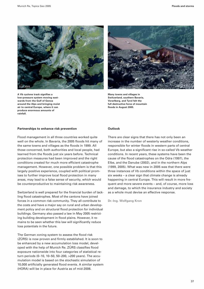
A Vb cyclone track signifies a low-pressure system moving east-wards from the Gulf of Genoaaround the Alps and bringing moistair to central Europe, where it canproduce enormous amounts of rainfall.
Many towns and villages in Switzerland, southern Bavaria, Vorarlberg, and Tyrol felt the full destructive force of mountainfloods in August 2005.
22.8.2005
Munich Re, Topics Geo 2005
38
Meteorological background
The precipitation pattern in India is primarily governed bymonsoons. The southwest or summer monsoon that blowsinland from the sea between June and October brings copious rainfall to most parts of the country. The largest volumes of rain are recorded on the west coast, in the West-ern Ghats, on the slopes of the Himalayas, and in northeastIndia (Cherrapunji: 11,000 mm/year). In the majority of thecountry, the summer monsoon accounts for 80–90% ofannual rainfall. Prolonged heavy downpours regularly causelarge-scale flooding, often accompanied by landslides. The valleys of the Jumma, Ganges, and Brahmaputra areseverely affected, with hundreds of people being killed every year.
The first monsoon rains of 2005 claimed no fewer than 200lives in the state of Gujarat between 25 June and 4 July.400,000 people had to be evacuated, and insured lossesamounted to approx. US$ 50m. On 26 and 27 July, theheaviest rainfall ever recorded in India fell in the state of
Maharashtra, including the financial and commercial centreMumbai. A precipitation depth of 944 mm was recorded in just 24 hours – surpassing the previous record for onesingle day in India (Cherrapunji, 1910). 94% of this amount(885 mm) fell in just 12 hours (between 11.30 a.m. and11.30 p.m. on 26 July). The downpour was accompanied byheavy thunderstorms and storm gusts. The meteorologicalreasons for this particularly extreme event are still uncer-tain. Prior to 26 July 2005, there had already been heavyrain in Goa and on the coast of Karnataka, which is an indi-cation of strong convection over the eastern Arabian Sea.Generally, rainfall activity in the Mumbai region reaches itshighest intensity in the last two weeks of July. However,the volumes varied widely from area to area. Whilst it wasthe meteorological station at Santa Cruz in the north ofMumbai that registered the amount of 944 mm, Colaba inthe south of the city only recorded 73 mm.
The entire system had an expanse of only 20–30 km, but radar measurements put the height of the cloud towers at 15 km.
Floods in Mumbai
Severe monsoon rains on the west coast of India caused high losses andclaimed many lives in the summer of 2005. The areas worst hit were thestates of Gujarat at the end of June and Maharashtra at the end of July.
Source: IE Graphics/B.K. Sharma, Indian Express Newspapers, Mumbai
Pune
Rajapur
2 The winds turn northwards, formingthroughs and even-tually vortexes.
1 High windsblow in fromthe ArabianSea.
3 Low pressure formsand strong windsshoot upwards, re-sulting in heavy rain.
Normalwinddirection
Torrential rain priorto 26 July
Gujarat
Maharashtra
Goa
ArabianSea
Mumbai
2
3
1
Precipitation distribution in Maharashtra, 25–27 July 2005 Schematic representation of an offshore vortex
Source: http://earthobservatory.nasa.gov
Inches
75 150 225
3 6 9
mm
Mumbai
39
Munich Re, Topics Geo 2005 Floods and storms
There were several determining factors
This kind of cloud system may be the result of an “offshorevortex“, in which strong winds with a high concentration of water vapour flow from the Arabian Sea onto the westcoast of India and come up against the Western Ghatsmountain range. As they cannot overcome this obstacle,the winds change direction and stream northwards alongthe mountains. This finally results in a vortex, which makesthe air masses spiral upwards in an anticlockwise directionand leads to heavy precipitation. Unlike a normal cloud-burst, which is of short duration because the rainfall vol-ume is limited by the amount of moisture transported, thisparticular cloud system was fed for quite some time withmoist air masses from the Arabian Sea. It is still not knownwhy an essentially short-lived vortex should have stayed in a stationary position over Mumbai for such a long time.The theory of an offshore vortex being the cause of the tor-rential rain in Mumbai is therefore contentious. The mostprobable explanation is that there was a combination ofvarious interrelated factors. The Intertropical ConvergenceZone, for example, which leads to intense convectionprocesses in the atmosphere (and hence to large volumesof rain), was directly at the latitude of Mumbai during theprecipitation event.
Mumbai flooded
The torrential rain swamped many districts of the city up to a depth of 3 m. Schools, banks, the stock exchange, andthe airport had to be closed. Traffic came to a standstill,and suburban and long-distance rail links were cut. 150,000people were stranded in railway stations. The situation wasparticularly critical in the area around Bhiwandi in thenortheast of the city, where large warehouses were badlydamaged. Bhiwandi is an important terminal for goods andcargo intended for Mumbai and the western Indian states.
The situation deteriorated east of Mumbai when the up-river dams were opened, causing the river to rise byabout 2 m within the space of an hour. Conditions in theslums, where about 70% of the city’s population live, werecatastrophic. Countless huts were so flimsy that they col-lapsed, and the occupants lost all their worldly posses-sions. The immense volumes of rain triggered scores oflandslides. Many people were electrocuted, buried undercollapsing walls, or drowned in flooded vehicles. Thedeath toll in Maharashtra was about 1,100. Hundreds ofcases of gastrointestinal diseases like cholera and dysen-tery were registered because the water was contamina-ted. With the warehouses in Bhiwandi damaged, therewere inadequate supplies of medication for the people.
The population was exposed to a further health hazard in the form of chemicals like cyanide, lead, zinc, and sul-phates which were found in the Mithi, the river that flowsthrough Mumbai. Most of these toxins came from illegalindustrial plants in the region and had been washed intothe river network by the rain.
The strong monsoon downpours put wholeareas of the state of Maharashtra under water,causing severe agricultural losses and damag-ing roads and railway lines.
Munich Re, Topics Geo 2005 Floods and storms
40
Overall claims picture and consequences for theinsurance industry
The floods in Mumbai were not only a human disaster butalso the costliest natural catastrophe in the history of theIndian insurance market. Munich Re’s estimate puts theoverall loss at US$ 770m. The main reason is that, unlikethe rest of the country, Mumbai has a high property insur-ance penetration. India’s largest primary insurance com-pany, for example, earns approx. 20–22% of its premiumincome in the Mumbai region. The average insurancepremium per person in Maharashtra is US$ 12, comparedwith about US$ 4 in India as a whole.
Although motor own damage accounted for the majority ofclaims, the overall loss amount is dominated by fire insur-ance claims. This was due to the fact that the standard firepolicy in India automatically includes flood damage. Mostof the policies in this sector cover depots and warehousesfor pharmaceutical products, electrical household appli-ances, electronic equipment, and textiles. The largest indi-vidual loss involved a sum of US$ 18m, which was due to a refinery being flooded. The Indian insurance industry sawthe floods in Mumbai as a landmark event – in a year al-ready characterised by natural catastrophes. As far as pri-mary insurers were concerned, however, its direct effectswere limited because the greater part of the loss was car-ried by the national and international reinsurance market.
In the short term, risk awareness may be expected to in-crease in the industrial sector of the Indian economy, buthardly among the population at large. Nevertheless, in-surance companies and the authorities resumed their discussion of the insurability of such accumulation lossesand the possibility of setting up a natural hazard reinsur-ance pool in India. Regardless of how natural hazards arereinsured in the future, by a pool or in the reinsurancemarket as in the past, the central issues for the Indian in-surance industry after the Mumbai floods are improvedtransparency of liabilities and risk-adequate premiums.
Tobias Ellenrieder
Mumbai, the financial and commercial centre,experienced record rainfalls at the end of July.Public life largely came to a standstill, in manyareas there was no electricity or drinking water.
For the Indian insurance industry, the floods inMumbai generated the most expensive naturalcatastrophe ever at US$ 770m. A loss adjusterindicates the water level in the storage depotof a pharmaceutical company.
From mid-June onwards, India experienced itsfirst heavy monsoon storms of 2005. This photo-graph of Ahmadabad in the state of Gujarat wastaken on 2 July.
41
Munich Re, Topics Geo 2005
Geographical underwriting – A central component of risk managementGeoinformatics is a discipline that Munich Re has pursued for more thanten years. Originally a piece of visionary thinking, it has developed overrecent years into applications that are now an indispensable part of riskmanagement.
Even in the mid-1990s, Geographical Information Systems(GIS) were still used at most as standalone solutions tosupport geo experts. Nowadays, complex GIS applicationsare an integral part of the IT environment at insurancecompanies and are widely used by underwriters in theirdaily business. The potential fields of application includevirtually all phases of the underwriting process, rangingfrom data capture and geocoding of insured risks to riskanalysis (accumulation issues and the identification of con-centrations and patterns of values), risk modelling, and thevisualisation of results. Our clients also benefit from thisarray of uses in the form of portfolio and claims analyses.
Success with address-based geocoding of risks
High-quality geocoding of portfolio and claims data iscrucial for risk management and portfolio optimisation inlines of business involving natural hazards and man-maderisks like terrorism. More than ten million risks have beengeocoded with their streets and house numbers in
18 European core markets and the US market – an importantstep towards more risk transparency in the underwritingprocess (Fig. 4).
Munich Re’s innovative web technologies provide under-writers with access to the Geo Data Service (GDS) andthus to the address-based geocoding of risks. Portfolioand claims data may be georeferenced in unlimited num-bers and used for detailed simulations and analyses.
Thanks to the excellent performance, large treaty portfolioswith over a million risk addresses can now be processed. Incountries with no address-based data, coarser geocoding iscarried out on the basis of the known CRESTA zones and aglobal city database.
Fig. 1 Identification of risks affected in flooded New Orleansafter Hurricane Katrina on 29 August 2005.
Flooded areas
Severely affected
Moderately affected
Risks in the affected area
Major damage
Slight damage
No damage
City centre New Orleans
Superdome
Lake Pontchartrain
Sources: Google Earth.com, fema.gov, digitalglobe.com
Munich Re, Topics Geo 2005 Geographical underwriting
42
These functions are also used in our products NATHAN andCatLossEstimation. The latter system is still being tested.Taking liability data and the latest information on wind-storms and severe weather events as a basis, it provides aquick estimate of the losses to be expected and their focalareas. The aim is to optimise loss management in themedium term.
As many primary insurers make little use of address-basedgeocoded portfolio data, Munich Re offers its clients a spe-cial service: MRGAP (Geographical Analysis of Portfolios),which is based on anonymised portfolio and claims data.The spatial analyses of property insurance portfolios makeit possible to identify unknown accumulation situations(hot spots) and potential accumulation effects of multi-location policies. Primary insurers are using this informa-tion more and more not only in traditional hazard-relatedanalyses but also for the purposes of managing their salesoperations and client acquisition.
Crucial test following Hurricane Katrina
In the aftermath of Hurricane Katrina, a team of MunichRe staff planned and performed a loss inspection usingfor the first time ever a mobile GIS unit (Fig. 2). These mobile systems make it possible to link up the damageidentified during the inspection with the liability datastored at the company. This kind of unit is usually madeup of a robust Personal Digital Assistant (PDA) and a powerful GPS receiver. The apparatus is fed with the geodata and software it needs for a specific situation. Beforethe team left for its loss inspection in August 2005, thesection of the portfolio for the region affected was pro-jected onto maps and satellite images stored in the sys-tem. Street data were used to plan the best possibleroute, and risks were soon identified. The incorporation of preliminary loss maps provided by the Federal Emer-gency Management Agency (FEMA) permitted speedyidentification and assessment of significant individuallosses. The team’s impressions from the inspection of numerous individual losses and the different levels ofdamage to residential, commercial, and industrial build-ings made it possible to make a preliminary estimate of the overall loss (Fig. 1).
Fig. 2 Munich Re’s geo expertswere on the spot inspecting lossesjust a few days after HurricaneKatrina struck.
Louisiana
Mississippi Alabama
Baton Rouge
New Orleans
Fig. 3 Distribution of offshorebusiness in the Gulf of Mexico.Superimposing the hurricanes’wind speeds gives an indicationof the exploration fields and rigsthat will be most seriously affec-ted and the losses that are to be expected.
Munich Re, Topics Geo 2005 Geographical underwriting
Geodatabases were also set up last year for the oil rigs inthe Gulf of Mexico. A good estimate of the losses causedby the hurricanes in 2005 was possible on the basis ofwind speed data. Firstly, liability values and the scope ofcover had to be specified for all the rigs. This informationforms the basis for simulating historical events, which isnecessary in order to calibrate the loss estimation model.Approaching storms can also be examined in terms oftheir loss potential for offshore business (Fig. 3).
Options far from being exhausted
These examples demonstrate only some of the methodsthat are already in use today, and represent only a fractionof the complete range of applications. Internet-based toolslike Google Earth (http://earth.google.com/) are a striking il-lustration of how Geographical Information Systems can bemade available to new target groups. Because once everypoint on earth can be accessed with just a few mouse clickson satellite images, this technology represents an efficientand practical tool for risk managers and underwriters. Whatis more, all kinds of cartographic data, such as risk loca-tions, can be superimposed on the images (Fig. 5). If thesetechniques can be integrated in operative processes in thecoming years, they will mark the beginning of a new era inrisk transparency.
Dr. Jürgen Schimetschek, Andreas Siebert
Fig.4 Countries covered by MunichRe’s street-based or address-basedgeocoding (January 2006).
Fig. 5 Detail from Google Earth.The fascinating combination ofsatellite imaging and specialist information will influence riskmanagement in the future.
Street-based or address-basedgeocoded locations of com-mercial risks in New Orleans.
Munich Re, Topics Geo 2005 Geographical underwriting
44
NATHAN
Global risk assessment of natural hazards – NATHAN(NATural Hazards Assessment Network):
NATHAN is based on “World of Natural Hazards“, aCD-ROM originally published in 2000, which has con-tinuously been updated since then. More than 100,000copies have now been produced, making it the mostwidely distributed media product in Munich Re’s 125-year history.
Our aim is to share our knowledge with the public. A free version of NATHAN can be accessed on the internet:
>> http://mrnathan.munichre.com
These are the features offered by NATHAN.
NATHAN is composed of three modules:
In the Natural Hazard Maps module, you place theHazard Pointer on any desired point on the earth’s landsurface and immediately get a qualitative estimate ofthe natural-hazard situation there.
The Major Disasters module provides information oneconomic and human losses from current and historicalnatural catastrophes worldwide.
The Country Profiles module provides an overview ofthe selected country’s geography, population, and economy, and shows its overall natural hazard situation.
Our clients can also access an extended version ofNATHAN at connect.munichre, which provides exclusive use of additional functions:
>> http://connect.munichre.com
Natural Hazard Maps
NATHAN – home page
Major Disasters
Country Profiles
45
Munich Re, Topics Geo 2005
Munich Re Foundation – From Knowledge to Action
Risk awareness is the key
The series of dramatic natural events shows no sign of stopping. The year 2005 has shown us once again that these kinds of catastrophes areunavoidable. The first requirement for effective disaster reduction is investment in greater risk awareness.
New records are being set every year. The sheer numberof events that happen, as reflected again in this edition ofTopics Geo, almost makes us forget that it is only oneyear since the huge tsunami in the Indian Ocean with itsdeath toll of more than 200,000 people.
No let-up
A look back: The United Nations declared the 1990s the“International Decade for Natural Disaster Reduction“(IDNDR) following the alarming catastrophe trends of the1980s. Subsequently, numerous national and internationalinitiatives were set up (e.g. UN-ISDR) with a view to opti-mising disaster reduction, many of which are still in placetoday. Although disaster victims have benefited from thisin many countries, we are still a long, long way from beingable to issue any kind of all-clear signal. In Bangladesh,which was hit by severe cyclones and devastating stormsurges in 1970 (300,000 fatalities) and 1991 (140,000 fatal-ities), a protection programme has been developed whichsignificantly reduces the number of victims. Today, peopleat risk from a natural catastrophe can seek protection atspecially built shelters. A warning signal tells them when itis time to go there.
And yet every year natural catastrophes still claim thelives of countless victims in countries around the world.The Bam earthquake in Iran with 26,000 fatalities, thetsunami in Asia and the earthquake in Pakistan are sadreminders that natural catastrophes still cause enormousdamage and loss of life. Numerous factors point to anequally bleak outlook for the future. Catastrophes willcontinue to increase around the world. The reasons forthis include population growth, an increasing concentra-tion of people and values as a consequence of urbanisa-tion, the settlement and industrialisation of exposed areassuch as coasts and river basins, the greater susceptibilityof modern societies and technologies and – especiallyhazardous – changes in the climate and the environment.
Early warning and the “last mile“
In January 2005, the Japanese city of Kobe hosted thesecond World Conference on Disaster Reduction (WCDR)after 1995. More than 3,000 delegates from 120 countriesdiscussed how we can improve disaster reduction acrossthe globe. The tsunami tragedy in the Indian Ocean cast a long shadow over the conference.
The phrase “last mile“ featured prominently in the Kobediscussions on improved early-warning systems. This re-volves around the issue of how to ensure that a technicallyimproved system – involving satellites, monitoring buoys,streams of messages, etc. – reaches the people at risk. It ispossible to develop an early-warning system which cansound the alarm many minutes before a tsunami strikes.The important thing, however, is to ensure that the warn-ings reach the people affected, such as the fishermen in Sri Lanka or the tourists in Thailand. This was the centralmessage of the deliberations.
There is no doubt that effective early-warning systems arevital. But it is here that the debate reveals its first inherentflaw. Doesn’t disaster reduction have to be designed withthe people at risk and their immediate needs in mind? Dothe people that make such decisions in the donor coun-tries really understand what a basket weaver in Vietnamor a fisherman in Indonesia needs? Shouldn’t the veryconcept of protecting people consider first and foremostthe different needs in different regions of the world anduse them as a basis for developing an adequate system of protection? Such a system acknowledges that people at risk in different cultural backgrounds and with manydifferent levels of education and needs will inevitably re-act in different ways to natural hazards. If we consider thepeople at risk to be in the “last mile“, we will continue tobe confronted with devastating images and tragedies inthe very first mile.
Munich Re, Topics Geo 2005 Munich Re Foundation – From Knowledge to Action
46
Prominent figures such as IrmgardSchwaetzer (DKKV), Bernd Eisen-blätter (GTZ), Sálvano Briceño(UN/ISDR) and Johan Schaar (IFRC)emphasised the importance of part-nership between politicians, industry,science and potential victims as a basis for answering the central ques-tions of risk reduction.
How can disaster reduction be improved for people at risk? This wasone of the questions to be clarified at the symposium. Representativesfrom the Philippines, Mozambique,and Kenya spelt out their wants andneeds.
At the end of the symposium, theexperts agreed on the HohenkammerCharter, which contains the ten mostimportant challenges for the future.
47
Munich Re, Topics Geo 2005 Munich Re Foundation – From Knowledge to Action
The last micrometre
The USA has excellent early-warning systems. Today, wecan follow live images of a hurricane as it happens. We aregiven “real time“ reports on the size of a storm, its inten-sity, path, landfall area, and the people at risk. In 2005,when Hurricane Katrina claimed the lives of more than1,300 people in one of the richest countries in the world, it helped to illustrate a particularly vital point: that even thebest and most sophisticated warning system is useless ifthe alert fails to reach the people at risk, or if the people arenot aware of how to act in a way that is appropriate to therisk. In New Orleans, a range of factors meant that manypeople did not heed the calls to evacuate – most of the rea-sons were poverty-related. Only if the people at risk are ad-equately informed about the consequences of earthquakes,cyclones and floods and know how to protect themselves insuch a situation is there any chance of actually reducing thedevastating effects of catastrophes. It is therefore not aquestion of the first or the last mile, it is about the final mi-crometre, the switch in your head that triggers appropriateindividual action. Risk awareness is the key here. If the people around the Indian Ocean had known more abouttsunamis and flood risks, thousands of lives would havebeen saved.
What can be done?
In November 2005, the Munich Re Foundation staged anevent at Hohenkammer near Munich, which was attendedby 100 participants from 30 countries, including leadingrepresentatives of international government and non-gov-ernment organisations, financial experts, and practition-ers. It was a symposium entitled “Worldwide disaster re-duction – Awareness is the key“ for insurance specialistsand experts from such institutions as the InternationalRed Cross, the GTZ (German Association for Technical Cooperation), the United Nations and the World Bank. The delegates addressed the most pressing tasks neededto optimise disaster reduction.
Thomas Loster
Hohenkammer CharterThe ten most important challenges for optimised risk reduction
PovertyPeople living in poverty are especially vulnerable; povertyrelief is therefore a key element.
PeopleDisaster reduction efforts must start with the people inthe areas at risk.
Decision-makersThe swift implementation of viable preventative measurespresupposes the committed involvement of decision-makers from communal to national government level.
DialogueThe exchange of views between those concerned must be actively pursued in order to achieve a common under-standing of the problems and solutions.
PartnershipsPoliticians, trade and industry, scientists and those af-fected have to cooperate better and more efficiently.Alliances – public-private partnerships – have to beinfused with life.
Development policyRisk reduction has to be singled out as one of the centralcomponents of development cooperation and nationalprogrammes, and implemented accordingly.
PropagationPromising approaches in respect of risk-adequate precau-tions that currently exist at local level must be transmittedand propagated worldwide.
IncentivesPolitical, legal and economic incentives are called for tosupport investment in disaster reduction, and to acceleratethe processes involved.
InsuranceRisk transfer, such as insurance and solidarity networks,helps reduce the vulnerability of governments and peoplein risk situations.
Raising risk awarenessDeveloping awareness is the key to the implementation of adequate measures before disaster strikes.
Munich Re, Topics Geo 2005
48
The meeting in Montreal was the first UN climate confer-ence to take place since the Kyoto agreement came intoforce in February 2005 and was attended by a record10,000 participants. Two major objectives were achieved:
The climate conference accepted the rules for implementingthe Kyoto Protocol that had been negotiated in Bonn andMarrakech in 2001. This means that emissions trading andother so-called flexibility mechanisms laid down in the Kyoto Protocol can finally be implemented in full. A compli-ance committee was also established to ensure that all Kyoto signatory countries observe the binding rules on howthe flexibility mechanisms – emissions trading, the cleandevelopment mechanism, and joint implementation – are tobe applied. The possible imposition of penalties is intendedto ensure that all the countries meet their reduction targets.Failure to meet emission targets will lead to the impositionof even stricter reduction obligations for the time after 2012or the exclusion from emissions trading with the ensuingnegative economic effects. Binding reduction targets willcontinue to apply after 2012 when the Kyoto commitmentperiod ends. In May 2006, a working group will begin pro-posing new and stricter emission standards for industrialcountries (Annex I countries) for the time after 2012. Prep-arations for this time are also being made in other ways. In the form of a non-binding dialogue in which the UnitedStates will participate, the states will discuss various sub-jects within the frame of the UN climate convention, includ-ing adaptation to climate change and technological andmarket-based options that will facilitate a response to climate change. Finally, the general review of the Kyoto Protocol is also meant to clarify which obligations the developing countries should adopt after 2012.
Respectable negotiating success:
Results of the UN climate conference in Montrealstabilise the emission-related carbon markets
The international climate negotiations in Montreal ended with an agreement on thesteps to be taken next in the struggle against global warming. The central issue onwhich the government delegations reached a consensus was the question of extendingthe Kyoto Protocol beyond 2012.
Negotiations end with respectable success:
With the full implementation of the Kyoto Protocol andthe path that will be adopted for the time after 2012 withthe prospect of further emission obligations, every possibleeffort has been made to avoid a gap between commit-ment periods. This means that a long-term perspectivebeyond 2012 has been established for political decision-making and for branches of the economy that are gearedto emission-related carbon markets and the Kyoto mech-anisms. On this basis, insurance products can be de-veloped that are geared to emissions trading or the insurance of CDM projects (carbon delivery guarantee).
Munich accents
Way back in 1995, Munich Re attended the very first climate summit in Berlin, giving active support to the endeavours against climate change.
Munich Re was in Montreal too, presenting the MunichClimate Insurance Initiative (MCII), which was launched inApril 2005 and whose members include the World Bank,the Potsdam Institute for Climate Impact Research, IIASA,and Germanwatch. Its objective is is to develop insurancesolutions that will enable people in developing countriesto obtain better protection against the impact of climatechange than is possible today.
The Climate Change Working Group of the UNEP FinanceInitiative, of which Munich Re is an active member, pre-sented a study on the financial sector’s expectations withregard to climate policy after 2012. Its central demandsare the formulation of a long-term objective for futureclimate policy, the establishment of a clear target for thedevelopment of renewable energies, an increase inenergy efficiency.
Dr. Eberhard Faust
49
Munich Re, Topics Geo 2005 Climate conference in Montreal
In April 2005, Munich Re launched theMunich Climate Insurance Initiative.Its objective is to devise insurancesolutions with which people in devel-oping countries can protect them-selves against the impact of climatechange better than they can at pres-ent. The initiative was presented anddiscussed at the UN climate confer-ence in Montreal.
At the end of the climate conference,former US President Bill Clinton gavea spirited speech championing cli-mate protection and highlighting theopportunities it presents for businessand the economy.
The Amazon Basin went through its worst drought for 60 years. Many stretches of river dried up, and hundreds ofvillages were cut off from the outside world. The agricul-tural sector and the fishing industry suffered large losses,whilst the overall loss is estimated to exceed US$ 1.6bn.
50
51
Munich Re, Topics Geo 2005
Climate review 2005
Climate change continues unabated. This is clearly con-firmed by the results of research in 2005, a year that islikely to go down as the second warmest year everrecorded.
According to provisional calculations by the World Me-teorological Organisation (WMO), the mean global tem-perature in 2005 deviated by +0.47°C from the average of the climate normal period 1961–1990. It is thus one of thewarmest years since recordings began in 1861 and cur-rently ranks as the second warmest year worldwide. The WMO will publish the final figures in February 2006.Nothing provides more striking evidence of the continualwarming of our planet than the fact that the nine warmestyears have all occurred between 1995 and 2005. In fact, in the northern hemisphere, 2005 is likely to go down asthe warmest year ever recorded, with an anomaly of+0.65°C.
In September 2005, ocean ice in the north covered lessthan six million square kilometres for the first time sincesatellite observations began in the 1970s. September isthe month in which it typically reaches its minimum. Thesea ice cover registered at the end of that month showeda reduction of 8% in the last 25 years.
A major part in this development was played by the NorthAtlantic, where the surface temperature in 2005 currentlyranks as the warmest annual mean figure ever registered(Fig. 1). The exceptionally large anomalies in a beltaround 50°N and record values in the Caribbean and thetropical Atlantic were particularly noticeable. One of theeffects of this was the extreme drought in the Amazon region. This was due to the higher level of evaporationand precipitation formation over the warm sea surfaces,whilst in the neighbouring region of North Brazil the prevailing conditions were a subsidence of air and clouddispersion.
A study by the Scripps Institute of Oceanography was the first to show that anthropogenic climate change is responsible for the rising temperatures in the upper layers of all the earth’s oceans. This influence far out-weighs the effects of natural climate variability and exter-nal forcings like changes in solar radiation and volcanicactivity.
Examples of extreme weather patterns in 2005
– Between October 2004 and June 2005, the total volumeof precipitation in western France, Spain, Portugal, andthe United Kingdom was only half the long-term aver-age. As a consequence, Spain and Portugal sufferedtheir worst drought since the 1940s, resulting in manywildfires. And that only two years after the hot and dryhundred-year summer of 2003.
– With an anomaly of +1.75°C in the first five months,2005 was the hottest year in Australia since recordingsbegan in 1910.
– There was hardly any rain in Brazil, leading to extremedryness in the south (Rio Grande do Sul) and theAmazon region and producing the worst drought for 60 years.
– In contrast, July presented Mumbai with the greatest 24-hour precipitation volume ever recorded in India.
Dr. Eberhard Faust
Fig. 1 Anomalies in the mean annualsea surface temperature in the NorthAtlantic relative to the average for the years 1961–1990. Black bar: average for January–November 2005.Grey: smoothed curve.
0.8
0.6
0.4
0.2
0.0
–0.2
–0.4
–0.6
Source: The Met Office and the University of East Anglia statement on the climate of 2005, 15 December 2005.
Fig. 1 Annual average sea surface temperaturein the North Atlantic
Supervisory BoardDr. jur. Hans-Jürgen Schinzler (Chairman), Herbert Bach, Hans-Georg Appel, Holger Emmert, Ulrich Hartmann, Dr. rer. nat. Rainer Janßen, Prof. Dr. rer. nat. Henning Kagermann, Prof. Dr. rer. nat. Drs. h. c. mult. Hubert Markl,Wolfgang Mayrhuber, Kerstin Michl, Prof. Karel Van Miert, Ingrid Müller, Prof. Dr. jur. Dr.-Ing. E. h. Heinrich v. Pierer, Dr. e. h. Dipl.-Ing. Bernd Pischetsrieder, Dr. rer. nat. Jürgen Schimetschek, Dr. jur. Dr. h. c. Albrecht Schmidt, Dr. phil. Ron Sommer, Wolfgang Stögbauer,Josef Süßl, Judy Võ
Responsible for contentCorporate Underwriting/Global ClientsGeo Risks Research/Environmental Management
The broad range of Munich Re’s geoscientificknowledge may be found at www.munichre.com.Besides supplying basic scientific and insuranceinformation on the subject of natural hazards, it presents analyses of topical loss events andinteractive hazard maps for all regions of theworld.