Page 1
2018 RIDE ROUTE UPDATED 5/22/18 | THERIDEFORMISSINGCHILDREN.COM | #RFMC
RIDE ROUTE OVERVIEW & STOPS: JUNE 1ST, 2018 Updated 5/22/2018
Leg Miles Depart Arrive Stop Time
Troop D to Staley 1 18.7 07:50a 9:16a 40 min Breakfast
Staley to Hart’s Hill 2 15.6 09:56a 11:14a 35 min Rest
Hart’s Hill to General Herkimer 3 9.9 11:49a 12:48p 40 min Lunch
General Herkimer to Barringer Rd. 4 11.2 1:28p 2:29p 35 min Rest
Barringer Rd. to MVCC 5 12.5 3:04p 4:19p 30 min Snack
MVCC to St. Luke’s 6 7.5 4:49p 5:30p 20 min Rest
St. Luke’s to Rec. Center 7 4.4 5:50p 6:19p Closing Ceremony
Total: 79.8
Join Us! Everyone is invited to join us at the New Hartford Recreation Center to welcome the
Riders home and for our Closing Ceremony with music and food!
Page 2
LEG 1: Troop D to Staley
Troop D - Staley
261 Genesee St, Oneida, NY
13421, USA
620 E Bloomfield St, Rome, NY
13440, USA
18.7 miles
Page 3
2018 RIDE ROUTE UPDATED 5/22/18 | THERIDEFORMISSINGCHILDREN.COM | #RFMC
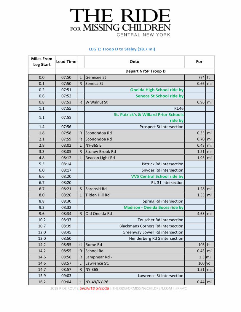
LEG 1: Troop D to Staley (18.7 mi)
Miles From
Leg Start Lead Time
Onto For
Depart NYSP Troop D
0.0 07:50 L Genesee St 774 ft
0.1 07:50 R Seneca St 0.66 mi
0.2 07:51 Oneida High School ride by
0.6 07:52 Seneca St School ride by
0.8 07:53 R W Walnut St 0.96 mi
1.1 07:55 Rt.46
1.1 07:55 St. Patrick's & Willard Prior Schools
ride by
1.4 07:56 Prospect St intersection
1.8 07:58 R Sconondoa Rd 0.33 mi
2.1 07:59 R Sconondoa Rd 0.70 mi
2.8 08:02 L NY-365 E 0.48 mi
3.3 08:05 R Stoney Brook Rd 1.51 mi
4.8 08:12 L Beacon Light Rd 1.95 mi
5.3 08:14 Patrick Rd intersection
6.0 08:17 Snyder Rd intersection
6.6 08:20 VVS Central School ride by
6.7 08:20 Rt. 31 intersection
6.7 08:21 S Sarenski Rd 1.28 mi
8.0 08:26 L Tilden Hill Rd 1.55 mi
8.8 08:30 Spring Rd intersection
9.2 08:32 Madison - Oneida Boces ride by
9.6 08:34 R Old Oneida Rd 4.63 mi
10.2 08:37 Teuscher Rd intersection
10.7 08:39 Blackmans Corners Rd intersection
12.0 08:45 Greenway Lowell Rd intersection
13.0 08:50 Henderberg Rd S intersection
14.2 08:55 sL Rome Rd 105 ft
14.2 08:55 R School Rd 0.43 mi
14.6 08:56 R Lamphear Rd - 1.3 mi
14.6 08:57 L Lawrence St. 100 yd
14.7 08:57 R NY-365 1.51 mi
15.9 09:03 Lawrence St intersection
16.2 09:04 L NY-49/NY-26 0.44 mi
Page 4
2018 RIDE ROUTE UPDATED 5/22/18 | THERIDEFORMISSINGCHILDREN.COM | #RFMC
16.6 09:06 S NY-26/NY-49/Erie Blvd 0.98 mi
17.0 09:08 Bridge over canal
17.6 09:11 R Black River Blvd 0.45 mi
17.9 09:12 Rome Fire Department
18.0 09:13 R Floyd Ave 1,319 ft
18.3 09:14 R E Bloomfield St 0.34 mi
18.6 09:15 R School on the right 315 ft
18.7 09:16 Staley Upper Elementary School on right (40 minute stop)
Page 5
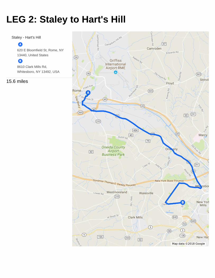
LEG 2: Staley to Hart's Hill
Staley - Hart's Hill
620 E Bloomfield St, Rome, NY
13440, United States
8610 Clark Mills Rd,
Whitesboro, NY 13492, USA
15.6 miles
Page 6
2018 RIDE ROUTE UPDATED 5/22/18 | THERIDEFORMISSINGCHILDREN.COM | #RFMC
LEG 2: Staley to Hart’s Hill (15.6 mi)
Miles From
Leg Start Lead Time
Onto For
Depart Staley Upper Elementary School
0.0 09:56 R E Bloomfield St 361 ft
0.1 09:56 R 6th St 0.28 mi
0.4 09:57 R Mohawk St 299 ft
0.4 09:58 L 5th St 889 ft
0.6 09:59 S Harbor Way 0.28 mi
0.9 10:00 L Mill St 1,214 ft
1.1 10:01 L Martin St 0.73 mi
1.8 10:05 L NY-69 4.96 mi
2.2 10:07 Stanwix Ave intersection
3.9 10:15 Teusher Rd
4.2 10:17 Nelson Hwy Intersection
4.5 10:18 Reber Rd
5.2 10:22 Monument Rd intersection
6.1 10:26 Airport Rd intersection
6.8 10:30 Utica St 1.54 mi
7.5 10:33 Oriskany High School ride by
7.9 10:35 Oriskany Fire Department
8.3 10:37 L Oklahoma Ave 148 ft
8.3 10:37 R NY-69/Erie Blvd 2.94 mi
8.6 10:39 N A Walbran elementary School
ride by
8.6 10:39 Shacksbury Rd intersection
9.2 10:42 Under power lines
9.8 10:45 Dale Rd. intersection
9.9 10:45 291 intersection
10.6 10:49 Under Thruway bridge
11.2 10:52 Whitesboro VFD Tribute
11.3 10:52 R Clinton St 381 ft
11.3 10:52 R West St 0.97 mi
11.7 10:54 Pine St and 1st St intersections
11.8 10:55 Hughes St intersection
12.0 10:56 Wilcox Intersection
12.1 10:56 Pleasantview Pl and Olena Dr intersections
Page 7
2018 RIDE ROUTE UPDATED 5/22/18 | THERIDEFORMISSINGCHILDREN.COM | #RFMC
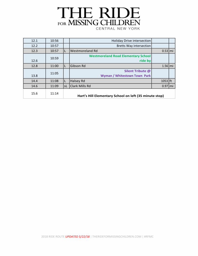
12.1 10:56 Holiday Drive intersection
12.2 10:57 Bretts Way intersection
12.3 10:57 L Westmoreland Rd 0.53 mi
12.6
10:59 Westmoreland Road Elementary School
ride by
12.8 11:00 L Gibson Rd 1.56 mi
13.8
11:05 Silent Tribute @
Wyman / Whitestown Town Park
14.4 11:08 L Halsey Rd 1053 ft
14.6 11:09 sL Clark Mills Rd 0.97 mi
15.6 11:14
Hart’s Hill Elementary School on left (35 minute stop)
Page 8
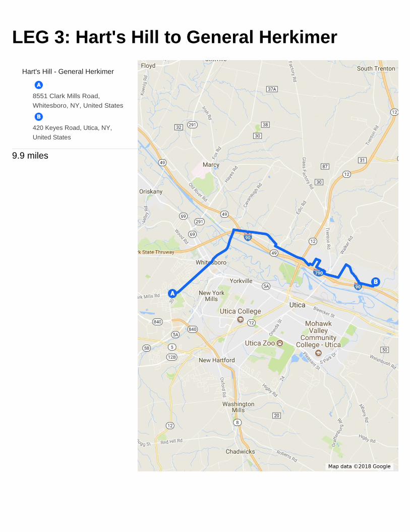
LEG 3: Hart's Hill to General Herkimer
Hart's Hill - General Herkimer
8551 Clark Mills Road,
Whitesboro, NY, United States
420 Keyes Road, Utica, NY,
United States
9.9 miles
Page 9
2018 RIDE ROUTE UPDATED 5/22/18 | THERIDEFORMISSINGCHILDREN.COM | #RFMC
LEG 3: Hart’s Hill to General Herkimer (9.9 mi)
Miles From
Leg Start Lead Time
Onto For
Depart Hart’s Hill Elementary School
0.0 11:49 L Clark Mills Rd 705 ft
0.1 11:49 S 30/Clinton St 1.62 mi
0.6 11:52 Hollywood Dr. intersection
1.1 11:55 Cresthill Dr. intersection
1.6 11:58 Rt. 69
1.8 11:59 S Mohawk St 1.22 mi
1.9 12:00 Bridge over train tracks
2.7 12:05 Silent Tribute on left
Immediately before canal
3.0 12:06 S Cavanaugh Rd 1,007 ft
3.2 12:07 R River Rd 0.5 mi
3.7 12:10 L Maynard Dr 1.2 mi
4.0 12:12 Marcy Elementary School ride by
4.0 12:13 Maynard Fire Department ride by
4.9 12:18 L River Rd 1.35 mi
5.2 12:20 Maynard Park intersection
5.4 12:21 Flanagan Rd intersection
5.9 12:24 Under Rt. 12
6.2 12:26 L Cosby Rd 335 ft
6.3 12:26 R Riverside Dr 499 ft
6.4 12:27 L Utica Rd 1,273 ft
6.6 12:28 R Booth St 807 ft
6.7
12:28 Thomas Jefferson Elementary School
ride by
6.8 12:29 R Coolidge Rd 1309 ft
7.0 12:30 L Riverside Dr 0.328 mi
7.3 12:32 R Riverside Dr 633 ft
7.5 12:33 S River Rd 0.46 mi
7.9 12:36 L Van Rensselaer Rd 0.52 mi
8.2 12:38 Garfield St intersection
8.4 12:39 R Deerfield Dr E 0.80 mi
8.6 12:40 John F. Kennedy Middle School
ride by
Page 10
2018 RIDE ROUTE UPDATED 5/22/18 | THERIDEFORMISSINGCHILDREN.COM | #RFMC
9.2 12:44 L Herkimer Rd 0.51 mi
9.8 12:47 L Keyes Rd 932 ft
9.9 12:48 General Herkimer Elementary School on right (40 minute stop)
Page 11
LEG 4: General Herkimer to Barringer Rd.
General Herkimer - Barringer Rd
420 Keyes Rd, Utica, NY 13502
326 Barringer Rd, Ilion, NY
13357, United States
11.2 miles
Page 12
2018 RIDE ROUTE UPDATED 5/22/18 | THERIDEFORMISSINGCHILDREN.COM | #RFMC
LEG 4: General Herkimer to Barringer Rd. (11.2 mi)
Miles From
Leg Start Lead Time
Onto For
Depart General Herkimer Elementary School
0.0 13:28 L Keyes Rd 1,109 ft
0.2 13:29 L Herkimer Rd 7.71 mi
0.5 13:31 Brody Dr. intersection
0.7 13:32 Park Edge Dr. intersection
0.9 13:33 Concord Dr. intersection
1.1 13:34 County Rd. intersection
1.3 13:35 Rodeo Dr. intersection
1.6 13:36 Wood Ln. intersection
1.6 13:36 Slavic School Ride by
2.0 13:39 Dyke Rd / Newport Rd intersection
3.0 13:44 Windfall Rd intersection
3.6 13:47 Drive In Rd. intersection
3.7 13:48 Bridge over NYS Thruway
4.6 13:53 Triple Rd. intersection
5.5 13:58 Carder Lane Rd. Intersection
6.1 14:01 Paratore Rd. intersection
6.4 14:03 Millers Grove Rd. intersection
7.0 14:06 Moss Rd. intersection
7.2 14:07 Watkins Rd. intersection
7.9 14:11 R Railroad St 0.60 mi
8.3 14:13 Silent Tribute on right
Frankfort Marina
8.4 14:14 Industrial Dr. intersection
8.5 14:14 L E Main St 0.48 mi
8.6 14:15 N/S Frankfort St. intersection
8.8 14:16 Palmer St. intersection
9.0 14:17 S Acme Rd 0.97 mi
9.2 14:18 Ives St. intersection
9.9 14:22 Under Rt. 5 overpass
10.0 14:22 S W Main St 0.26 mi
10.2 14:24 R Barringer Rd 1 mi
10.4 14:25 W Prospect St. intersection
10.5 14:25 W. Montgomery St. intersection
10.6 14:26 2nd St. intersection
Page 13
2018 RIDE ROUTE UPDATED 5/22/18 | THERIDEFORMISSINGCHILDREN.COM | #RFMC
10.9 14:27 Ray St. N intersection
11.1 14:28 Ade St. intersection
11.2 14:29 Barringer Rd. Elementary School on Right (35 minute stop)
Page 14
LEG 5: Barringer Rd. to MVCC
Barringer Rd. - MVCC
326 Barringer Rd, Ilion, NY
13357
1245 Tilden Ave, Utica, NY
13501, USA
12.5 miles
Page 15
2018 RIDE ROUTE UPDATED 5/22/18 | THERIDEFORMISSINGCHILDREN.COM | #RFMC
LEG 5: Barringer Rd. to MVCC (12.5 mi)
Miles From
Leg Start Lead Time
Onto For
Depart Barringer Rd. Elementary School
0.0 15:04 L Barringer Rd 0.68 mi
0.2 15:05 George St. intersection
0.3 15:06 Concord St. intersection
0.5 15:07 2nd St. intersection
0.7 15:08 L W Montgomery St 535 ft
0.8 15:09 R Division St 673 ft
0.9 15:10 L W Prospect St 0.34 mi
1.2 15:12 R McGowan Rd 1296 ft
1.5 15:13 L W Main St 591 ft
1.6 15:14 S Acme Rd 0.88 mi
1.6 15:14 Under Rt. 5 overpass
2.3 15:18 Ives St. intersection
2.5 15:19 S E Main St 1.27 mi
2.7 15:20 Palmer St. intersection
2.9 15:21 N/S Frankfort St. intersection
3.0 15:22 N/S Litchfield St. intersection
3.2 15:23 Cemetery St. intersection
3.6 15:26 Adams St. intersection
3.8 15:27 S Southside Rd 4.98 mi
4.6 15:32 Mucky Run Rd. intersection
8.1 15:53 E River R. intersection
8.7 15:57 R Dyke Rd Spur 436 ft
8.8 15:57 L Dyke Rd 0.27 mi
9.1 15:59 R Bleecker St 741 ft
9.2 16:00 L Ferguson Rd 0.93 mi
9.4 16:01 Towne Rd. intersection
9.6 16:02 Argyle Rd. intersection
9.7 16:02 Willow Ln. intersection
9.8 16:03 School Ln. intersection
9.8 16:03 Utica Charter School of Science ride by
10.2 16:05 R Welshbush Rd 1.54 mi
10.4 16:07 Industrial Park Dr. intersection
10.8 16:09 Rolling Hills Dr. intersection
Page 16
2018 RIDE ROUTE UPDATED 5/22/18 | THERIDEFORMISSINGCHILDREN.COM | #RFMC
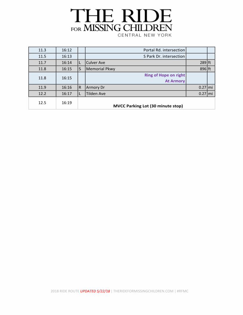
11.3 16:12 Portal Rd. intersection
11.5 16:13 S Park Dr. intersection
11.7 16:14 L Culver Ave 289 ft
11.8 16:15 S Memorial Pkwy 896 ft
11.8 16:15 Ring of Hope on right
At Armory
11.9 16:16 R Armory Dr 0.27 mi
12.2 16:17 L Tilden Ave 0.27 mi
12.5 16:19 MVCC Parking Lot (30 minute stop)
Page 17
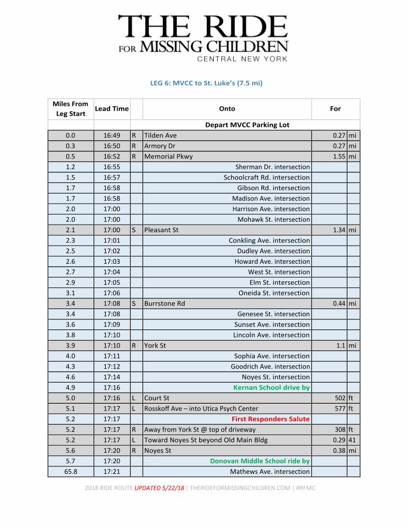
LEG 6: MVCC to St. Luke's
MVCC - St. Luke's
1245 Tilden Ave, Utica, NY
13501, USA
1756 Burrstone Rd, New
Hartford, NY 13413, USA
7.5 miles
Page 18
2018 RIDE ROUTE UPDATED 5/22/18 | THERIDEFORMISSINGCHILDREN.COM | #RFMC
LEG 6: MVCC to St. Luke’s (7.5 mi)
Miles From
Leg Start Lead Time
Onto For
Depart MVCC Parking Lot
0.0 16:49 R Tilden Ave 0.27 mi
0.3 16:50 R Armory Dr 0.27 mi
0.5 16:52 R Memorial Pkwy 1.55 mi
1.2 16:55 Sherman Dr. intersection
1.5 16:57 Schoolcraft Rd. intersection
1.7 16:58 Gibson Rd. intersection
1.7 16:58 Madison Ave. intersection
2.0 17:00 Harrison Ave. intersection
2.0 17:00 Mohawk St. intersection
2.1 17:00 S Pleasant St 1.34 mi
2.3 17:01 Conkling Ave. intersection
2.5 17:02 Dudley Ave. intersection
2.6 17:03 Howard Ave. intersection
2.7 17:04 West St. intersection
2.9 17:05 Elm St. intersection
3.1 17:06 Oneida St. intersection
3.4 17:08 S Burrstone Rd 0.44 mi
3.4 17:08 Genesee St. intersection
3.6 17:09 Sunset Ave. intersection
3.8 17:10 Lincoln Ave. intersection
3.9 17:10 R York St 1.1 mi
4.0 17:11 Sophia Ave. intersection
4.3 17:12 Goodrich Ave. intersection
4.6 17:14 Noyes St. intersection
4.9 17:16 Kernan School drive by
5.0 17:16 L Court St 502 ft
5.1 17:17 L Rosskoff Ave – into Utica Psych Center 577 ft
5.2 17:17 First Responders Salute
5.2 17:17 R Away from York St @ top of driveway 308 ft
5.2 17:17 L Toward Noyes St beyond Old Main Bldg 0.29 41
5.6 17:20 R Noyes St 0.38 mi
5.7 17:20 Donovan Middle School ride by
65.8 17:21 Mathews Ave. intersection
Page 19
2018 RIDE ROUTE UPDATED 5/22/18 | THERIDEFORMISSINGCHILDREN.COM | #RFMC
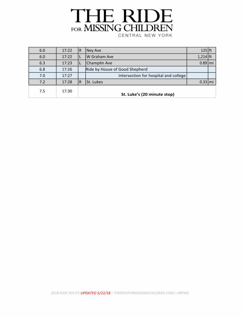
6.0 17:22 R Ney Ave 125 ft
6.0 17:22 L W Graham Ave 1,214 ft
6.3 17:23 L Champlin Ave 0.89 mi
6.8 17:26 Ride by House of Good Shepherd
7.0 17:27 Intersection for hospital and college
7.2 17:28 R St. Lukes 0.33 mi
7.5 17:30 St. Luke’s (20 minute stop)
Page 20
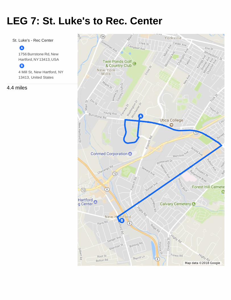
LEG 7: St. Luke's to Rec. Center
St. Luke's - Rec Center
1756 Burrstone Rd, New
Hartford, NY 13413, USA
4 Mill St, New Hartford, NY
13413, United States
4.4 miles
Page 21
LEG 7: St. Luke’s to Rec. Center (4.4 mi)
Miles From
Leg Start Lead Time
Onto For
Depart St. Lukes
0.0 17:50 R Burrstone Rd 1125 ft
0.2 17:51 L Business Park Dr 0.606 mi
0.8 17:55 L Notre Dame Ln 0.258 mi
1.1 17:57 Notre Dame School ride by
1.1 17:57 R Burrstone Rd 1.3 mi
1.5 18:00 Champlin Ave. intersection
1.8 18:02 Arterial entrance/exit intersection
2.1 18:04 Lincoln Ave. intersection
2.4 18:06 Sunset Ave. intersection
2.4 18:06 R Genesee St 1.93 mi
2.8 18:09 Arnold Ave. intersection
3.1 18:11 Amy Ave. intersection
3.4 18:13 Melrose Ave. intersection
3.7 18:15 Meeker Ave. intersection
4.0 18:16 Railroad tracks
4.3 18:18 Richardson Ave. intersection
4.3 18:18 L Oxford Rd 387 ft
4.4 18:19 L Mill St. 230 ft
4.4 18:19
New Hartford Rec. Center (end of ride)
2018 RIDE ROUTE UPDATED 5/22/18 | THERIDEFORMISSINGCHILDREN.COM | #RFMC