40
ICHARM Public Works Research Institute (PWRI) Tsukuba, Japan Akira TERAKAWA Toward Integrated Flood Risk Management ー ー ー Outline of ICHARM ー ー ー

ICHARM
Public Works Research Institute (PWRI)
Tsukuba, Japan
Akira TERAKAWA
Toward Integrated Flood Risk Management
ーーーー Outline of ICHARM ーーーー
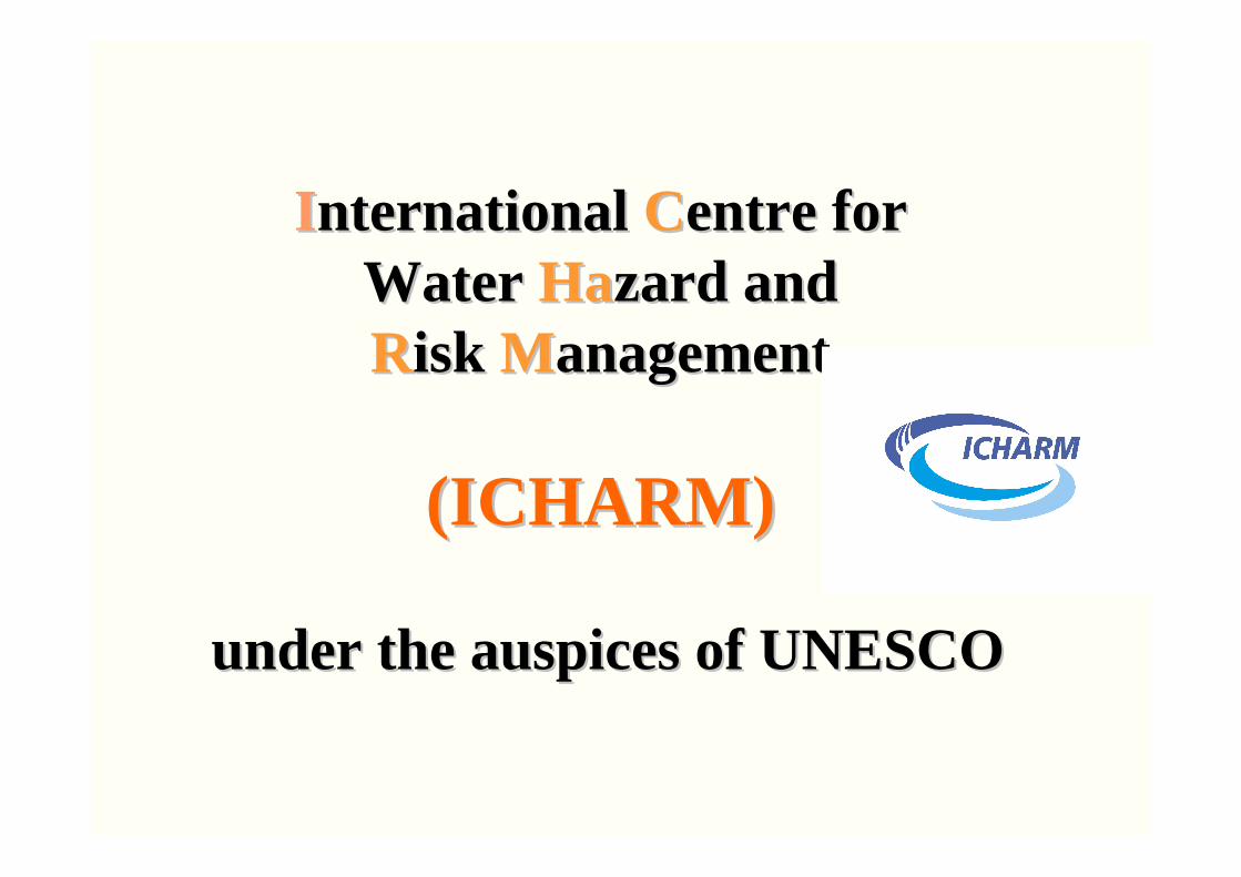
IInternational nternational CCentre for entre for Water Water HaHazard and zard and RRisk isk MManagementanagement
(ICHARM)(ICHARM)
under the auspices of UNESCOunder the auspices of UNESCO

Background: Birth of ICHARM
• IDNDR 1990-1999 & ISDR 2000-, MDGs, WSSD, Hyogo Framework of Action 2005 etc.
• ICHARM was proposed by the Japanese Government and approved at UNESCO 33rd
General Conference, October 2005• Agreements signed by UNESCO, G of
Japan & PWRI on March 3, 2006• ICHARM was established on March 6, 2006
– A UNESCO Category II Global Center hosted by Public Works Research Institute (PWRI), Tsukuba, Japan
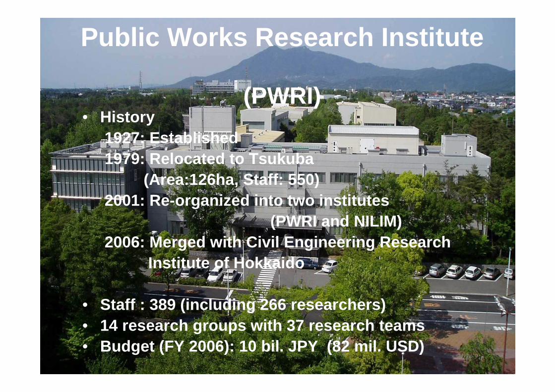
Public Works Research Institute
(PWRI)• History
1927: Established1979: Relocated to Tsukuba
(Area:126ha, Staff: 550) 2001: Re-organized into two institutes
(PWRI and NILIM)2006: Merged with Civil Engineering Research
Institute of Hokkaido
• Staff : 389 (including 266 researchers)• 14 research groups with 37 research teams• Budget (FY 2006): 10 bil. JPY (82 mil. USD)

Missions of ICHARMThe mission of ICHARM is to function as an international center for providing and assisting the implementation of the most practicable strategies to prevent and mitigate water related disasters (floods, droughts, sediment-related disasters, tsunamis, storm surges, water contamination, etc.) in the world.
※ Focus on flood related disasters at the initial stage
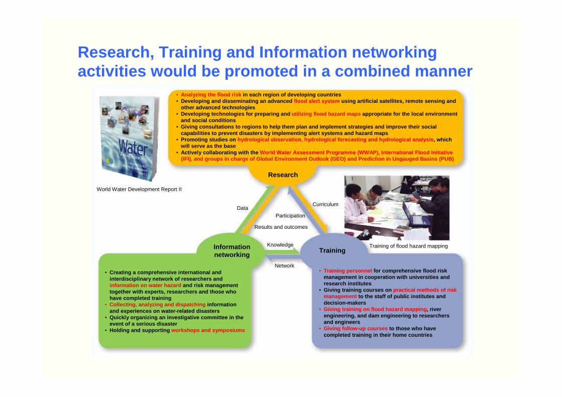
• Analyzing the flood risk in each region of developing countries• Developing and disseminating an advanced flood alert system using artificial satellites, remote sensing and
other advanced technologies• Developing technologies for preparing and utilizing flood hazard maps appropriate for the local environment
and social conditions• Giving consultations to regions to help them plan a nd implement strategies and improve their social
capabilities to prevent disasters by implementing a lert systems and hazard maps• Promoting studies on hydrological observation, hydrological forecasting and hydrological analysis , which
will serve as the base• Actively collaborating with the World Water Assessment Programme (WWAP), Internatio nal Flood Initiative
(IFI), and groups in charge of Global Environment O utlook (GEO) and Prediction in Ungauged Basins (PUB)
World Water Development Report II
Research
DataCurriculum
Results and outcomes
Participation
Knowledge
Network
Training of flood hazard mappingInformation networking
Training
• Creating a comprehensive international and interdisciplinary network of researchers and information on water hazard and risk management together with experts, researchers and those who have completed training
• Collecting, analyzing and dispatching information and experiences on water-related disasters
• Quickly organizing an investigative committee in th e event of a serious disaster
• Holding and supporting workshops and symposiums
• Training personnel for comprehensive flood risk management in cooperation with universities and research institutes
• Giving training courses on practical methods of risk management to the staff of public institutes and decision-makers
• Giving training on flood hazard mapping , river engineering, and dam engineering to researchers and engineers
• Giving follow-up courses to those who have completed training in their home countries
Research, Training and Information networking activities would be promoted in a combined manner
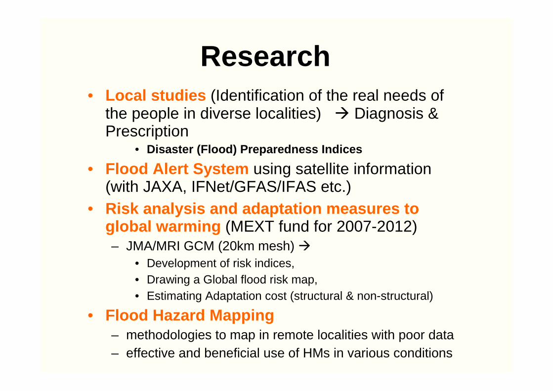
Research• Local studies (Identification of the real needs of
the people in diverse localities) � Diagnosis & Prescription
• Disaster (Flood) Preparedness Indices
• Flood Alert System using satellite information (with JAXA, IFNet/GFAS/IFAS etc.)
• Risk analysis and adaptation measures to global warming (MEXT fund for 2007-2012) – JMA/MRI GCM (20km mesh) �
• Development of risk indices, • Drawing a Global flood risk map, • Estimating Adaptation cost (structural & non-structural)
• Flood Hazard Mapping– methodologies to map in remote localities with poor data– effective and beneficial use of HMs in various conditions
Capacity Building• Training courses
– Flood hazard mapping course started in 2004
– River and Dam engineering course started in 1969
• Follow up program for ex-trainees
• Master course on Flood Disaster Management with National Graduate Institute for Policy Studies (GRIPS)
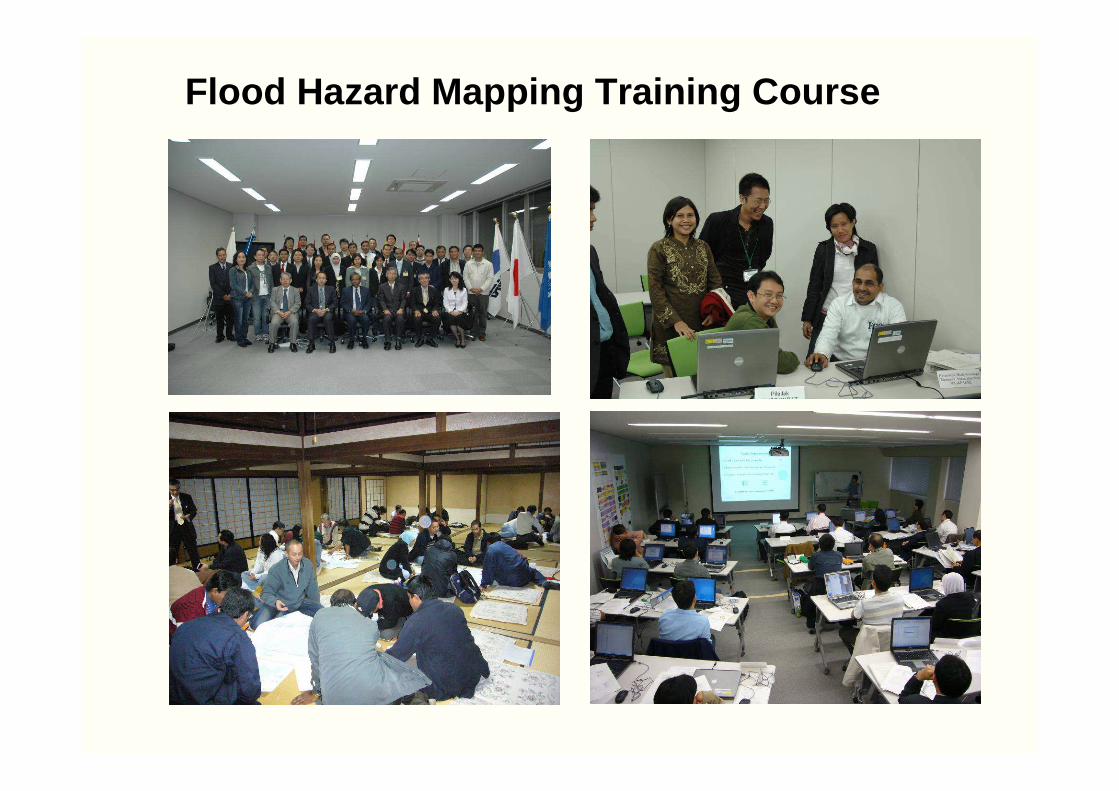
Flood Hazard Mapping Training Course
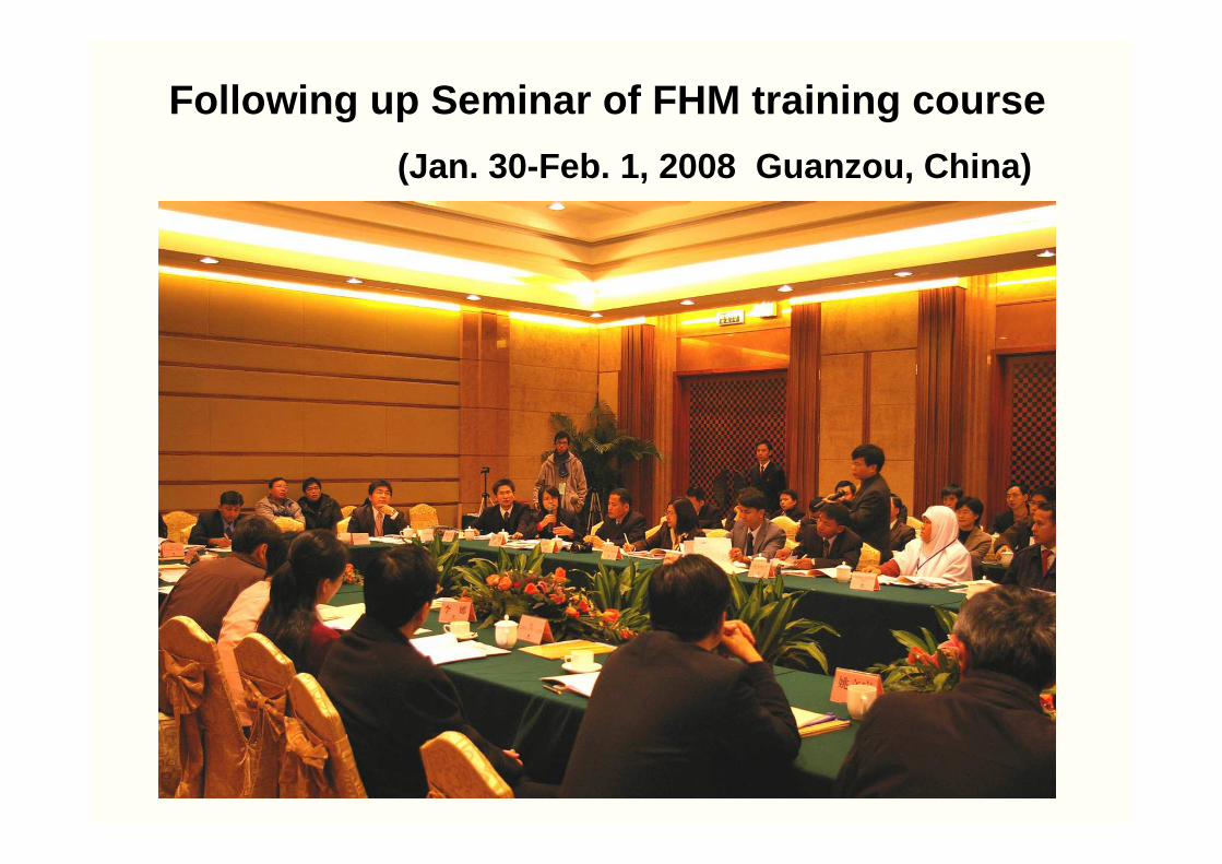
Following up Seminar of FHM training course
(Jan. 30-Feb. 1, 2008 Guanzou, China)
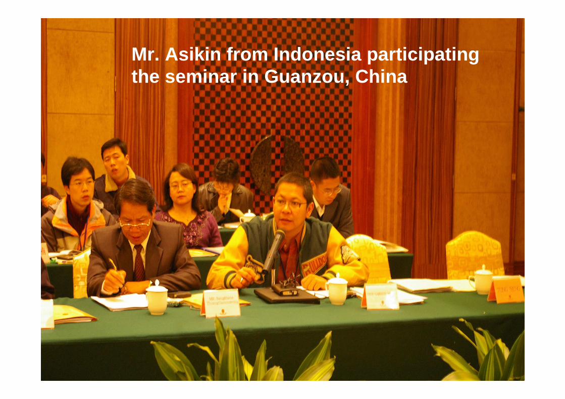
Mr. Asikin from Indonesia participating the seminar in Guanzou, China
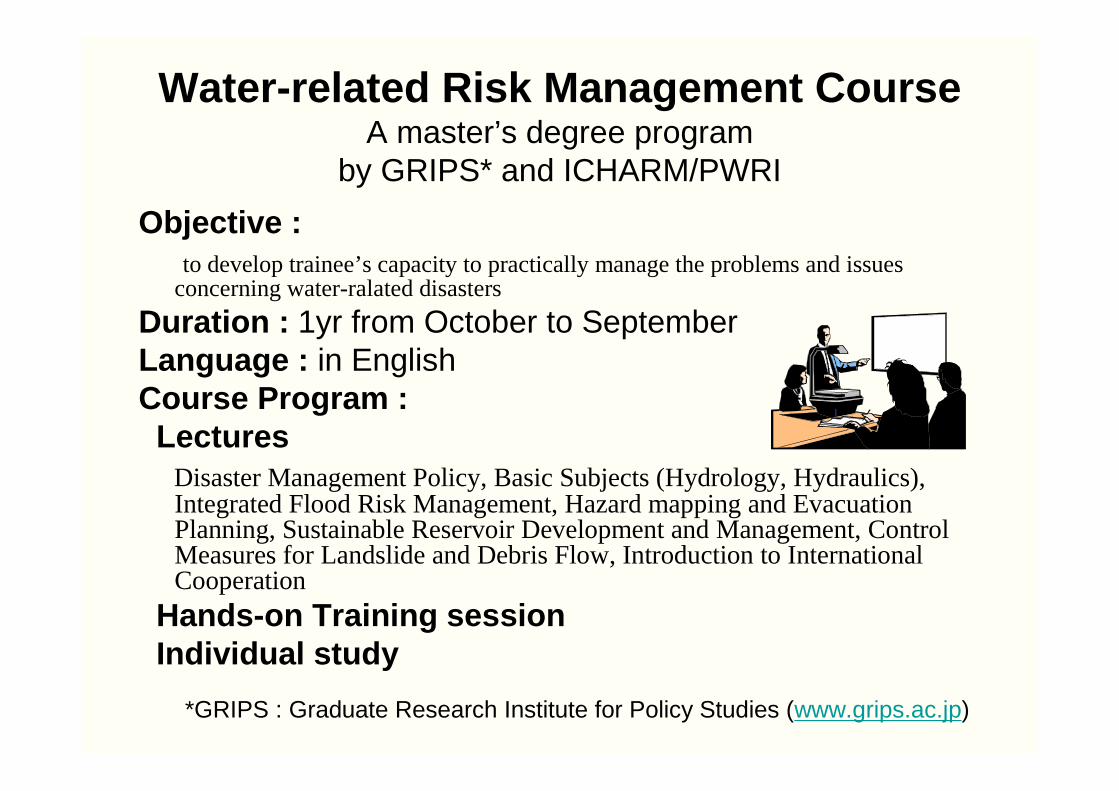
Water-related Risk Management CourseA master’s degree program
by GRIPS* and ICHARM/PWRI
Objective :to develop trainee’s capacity to practically manage the problems and issues
concerning water-ralated disasters
Duration : 1yr from October to SeptemberLanguage : in EnglishCourse Program :Lectures
Disaster Management Policy, Basic Subjects (Hydrology, Hydraulics), Integrated Flood Risk Management, Hazard mapping and Evacuation Planning, Sustainable Reservoir Development and Management, Control Measures for Landslide and Debris Flow, Introduction to International Cooperation
Hands-on Training sessionIndividual study
*GRIPS : Graduate Research Institute for Policy Studies (www.grips.ac.jp)
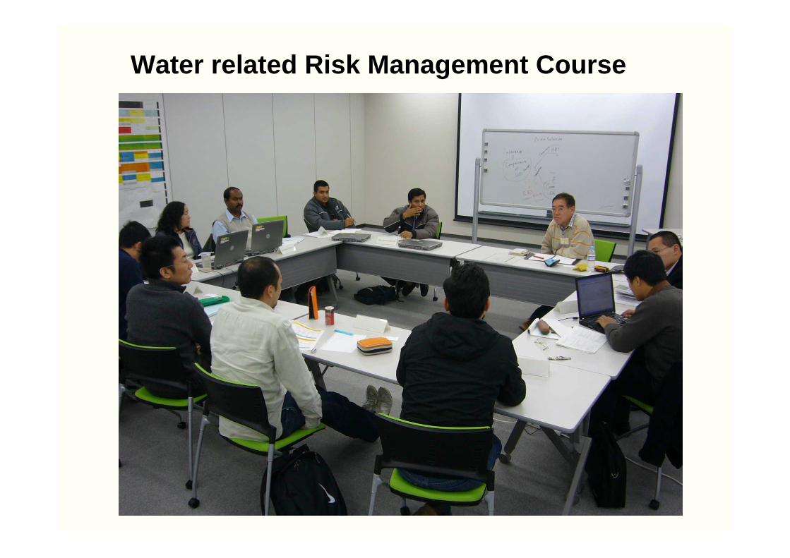
Water related Risk Management Course
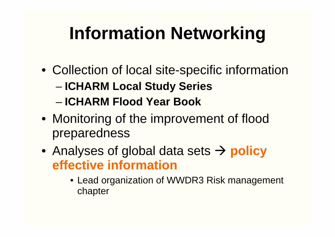
Information Networking
• Collection of local site-specific information– ICHARM Local Study Series – ICHARM Flood Year Book
• Monitoring of the improvement of flood preparedness
• Analyses of global data sets � policy effective information
• Lead organization of WWDR3 Risk management chapter
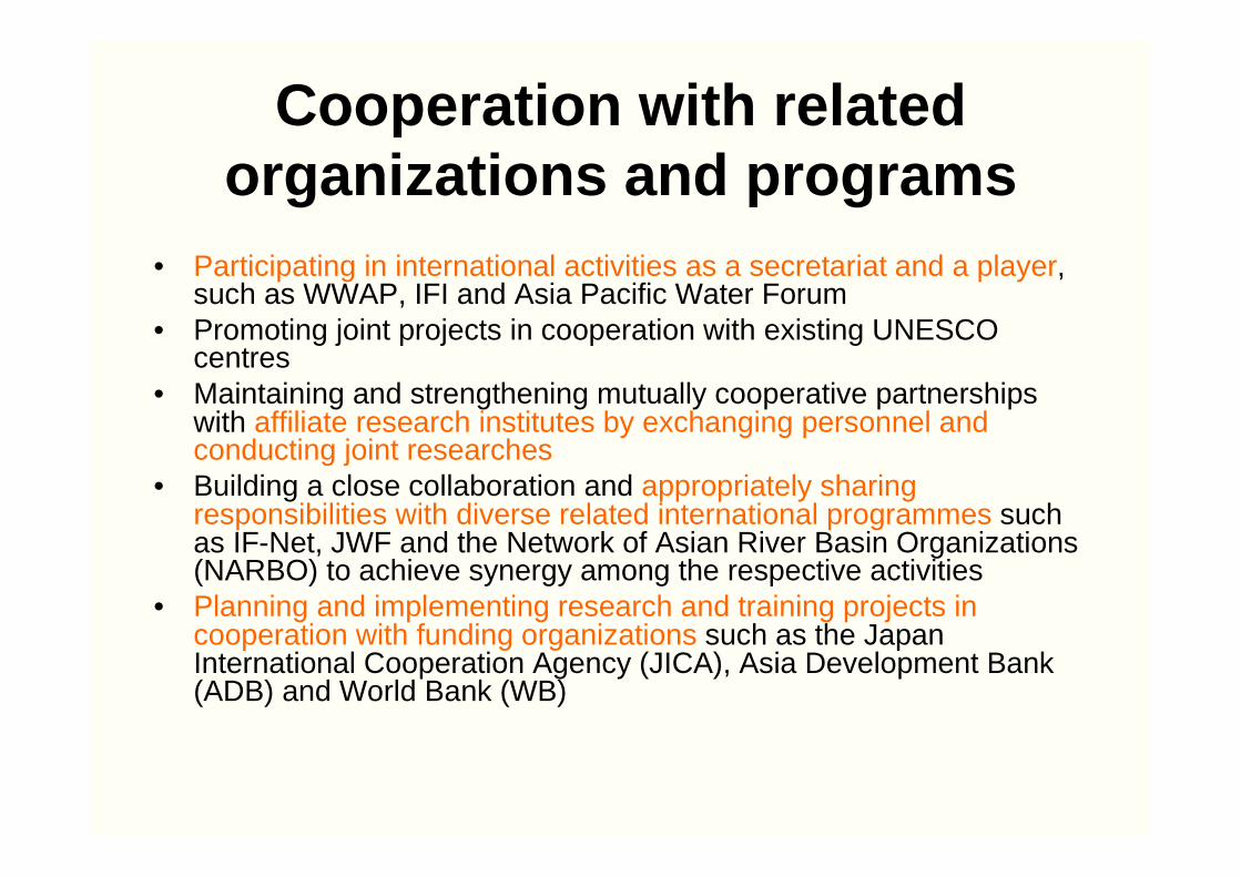
Cooperation with related organizations and programs
• Participating in international activities as a secretariat and a player, such as WWAP, IFI and Asia Pacific Water Forum
• Promoting joint projects in cooperation with existing UNESCO centres
• Maintaining and strengthening mutually cooperative partnerships with affiliate research institutes by exchanging personnel and conducting joint researches
• Building a close collaboration and appropriately sharing responsibilities with diverse related international programmes such as IF-Net, JWF and the Network of Asian River Basin Organizations (NARBO) to achieve synergy among the respective activities
• Planning and implementing research and training projects in cooperation with funding organizations such as the Japan International Cooperation Agency (JICA), Asia Development Bank (ADB) and World Bank (WB)
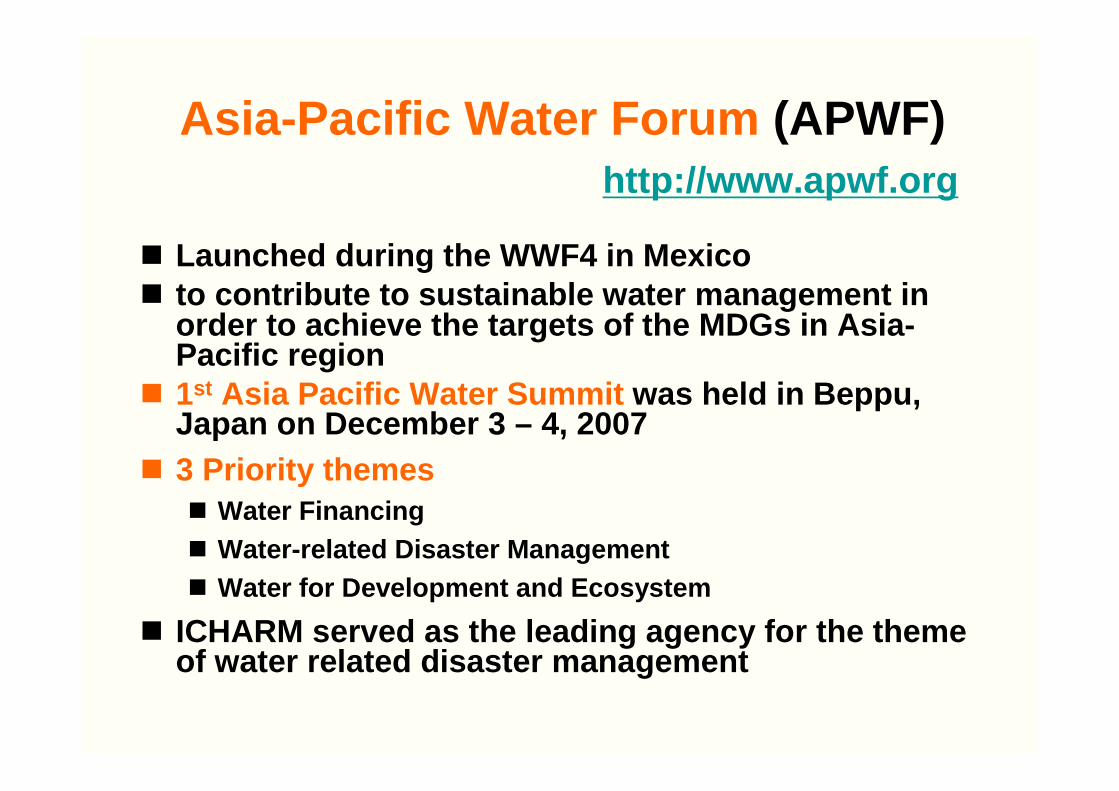
� Launched during the WWF4 in Mexico� to contribute to sustainable water management in
order to achieve the targets of the MDGs in Asia-Pacific region
� 1st Asia Pacific Water Summit was held in Beppu, Japan on December 3 – 4, 2007
� 3 Priority themes� Water Financing� Water-related Disaster Management� Water for Development and Ecosystem
� ICHARM served as the leading agency for the theme of water related disaster management
Asia-Pacific Water Forum (APWF)http://www.apwf.org

Recommendations agreed among the participants for Theme B session
• Integrate water-related Disaster Risk Reduction (DRR) into national development plans, recognizing adaptation to increasing risks from climate change as a “highest”priority issue.
• Recognize the importance of IWRM for water-related DRR and the need to strengthen comprehensive structural and non-structural measures
• Establish national and local goals/targets for water-related DRR, taking the impacts of climate change into consideration
• Develop preparedness indices for water-related DRR for the Asia-Pacific region
• Develop water-related disaster warning systems and human capacities
• Establish regional knowledge hub for Water-related DRR
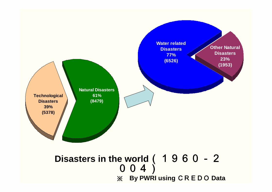
Disasters in the world (1960-2(1960-2(1960-2(1960-2004)004)004)004)※※※※ By PWRI using CREDOCREDOCREDOCREDO Data
Natural Disasters61%
(8479)Technological
Disasters39%
(5378)
Water relatedDisasters
77%(6526)
Other NaturalDisasters
23%(1953)
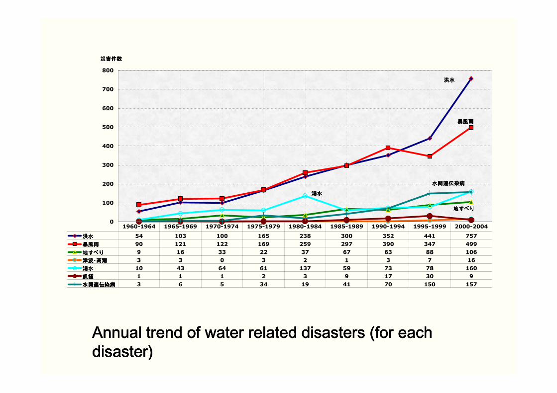
洪水洪水洪水洪水
暴風雨暴風雨暴風雨暴風雨
地すべり地すべり地すべり地すべり
渇水渇水渇水渇水
水関連伝染病水関連伝染病水関連伝染病水関連伝染病
0
100
200
300
400
500
600
700
800
災害件数災害件数災害件数災害件数
洪水洪水洪水洪水 54 103 100 165 238 300 352 441 757
暴風雨暴風雨暴風雨暴風雨 90 121 122 169 259 297 390 347 499
地すべり地すべり地すべり地すべり 9 16 33 22 37 67 63 88 106
津波・高潮津波・高潮津波・高潮津波・高潮 3 3 0 3 2 1 3 7 16
渇水渇水渇水渇水 10 43 64 61 137 59 73 78 160
飢饉飢饉飢饉飢饉 1 1 1 2 3 9 17 30 9
水関連伝染病水関連伝染病水関連伝染病水関連伝染病 3 6 5 34 19 41 70 150 157
1960-1964 1965-1969 1970-1974 1975-1979 1980-1984 1985-1989 1990-1994 1995-1999 2000-2004
Annual trend of water related disasters (for each Annual trend of water related disasters (for each Annual trend of water related disasters (for each Annual trend of water related disasters (for each disaster)disaster)disaster)disaster)
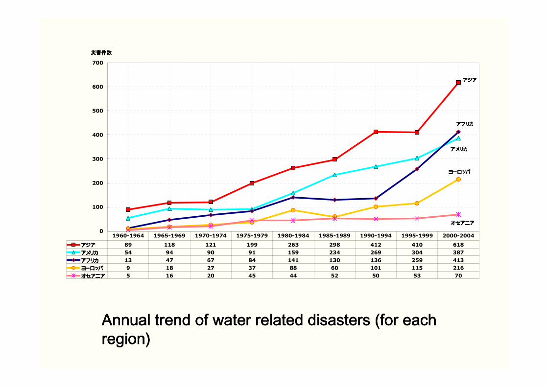
アジアアジアアジアアジア
アメリカアメリカアメリカアメリカ
アフリカアフリカアフリカアフリカ
ヨーロッパヨーロッパヨーロッパヨーロッパ
オセアニアオセアニアオセアニアオセアニア0
100
200
300
400
500
600
700
災害件数災害件数災害件数災害件数
アジアアジアアジアアジア 89 118 121 199 263 298 412 410 618
アメリカアメリカアメリカアメリカ 54 94 90 91 159 234 269 304 387
アフリカアフリカアフリカアフリカ 13 47 67 84 141 130 136 259 413
ヨーロッパヨーロッパヨーロッパヨーロッパ 9 18 27 37 88 60 101 115 216
オセアニアオセアニアオセアニアオセアニア 5 16 20 45 44 52 50 53 70
1960-1964 1965-1969 1970-1974 1975-1979 1980-1984 1985-1989 1990-1994 1995-1999 2000-2004
Annual trend of water related disasters (for each Annual trend of water related disasters (for each Annual trend of water related disasters (for each Annual trend of water related disasters (for each region)region)region)region)

EmergencyFlood fightingInformation sharingEvacuation orderRescue operationEvacuation camp
PreventionRiver improvementStrengthening of leveeStorage facilityLand use regulationembankment
MitigationFlood hazard mapFlood forecasting/warningFlood insuranceDisaster prevention drillWater proofing of buildings
RecoveryRecovery operationPrevention of epidemicsReconstruction of buildingsInvestigation of causeDrawing lessons
Proactive Reactive
Integrated risk management considering the total balance of proactive and reactive measures is important
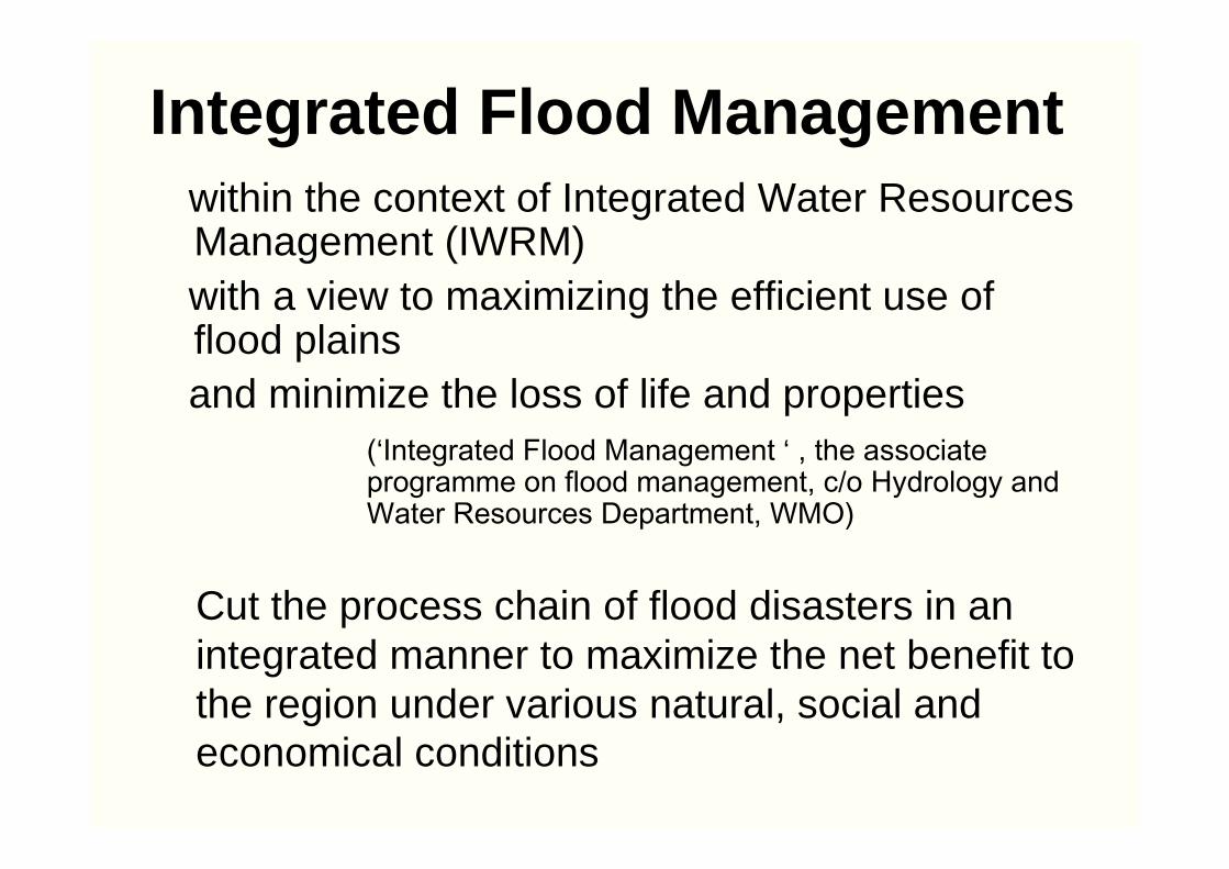
Integrated Flood Managementwithin the context of Integrated Water Resources Management (IWRM)with a view to maximizing the efficient use of flood plainsand minimize the loss of life and properties
(‘Integrated Flood Management ‘ , the associate programme on flood management, c/o Hydrology and Water Resources Department, WMO)
Cut the process chain of flood disasters in an integrated manner to maximize the net benefit to the region under various natural, social and economical conditions
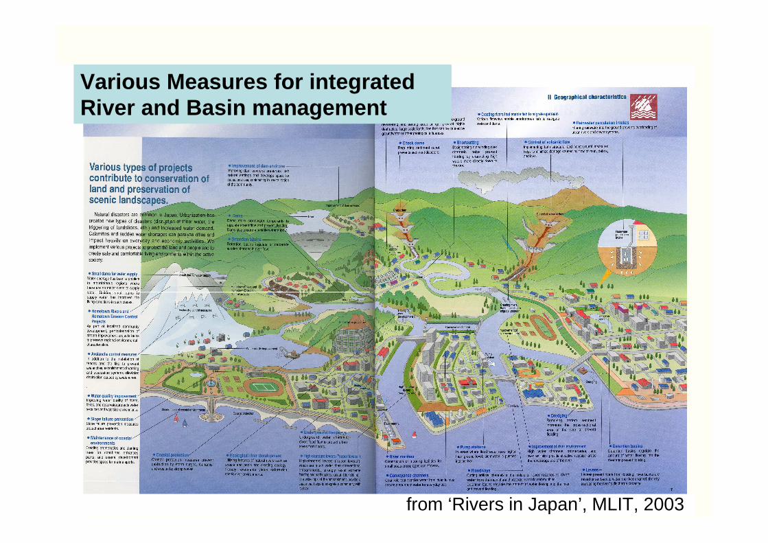
Various Measures for integrated River and Basin management
from ‘Rivers in Japan’, MLIT, 2003

Urbanization rate of 10% I n 1958
Urbanization rate of 60% in 1975
Urbanization rate of 84.3% in 1997
Flooding of September 1976
Developments of Heights and Hilly Zones: Tsurumi River (through Tokyo metropolis and Kanagawa Prefecture)
Flooded areas
Extensive Housing Land Development has been in Progress in the Heights and Hilly Zones of the Suburban Areas in the Three Major Metropolitan Regions.
Extensive Housing Land Development has been in Progress iExtensive Housing Land Development has been in Progress in the n the Heights and Hilly Zones of the Suburban Areas in the Three MajoHeights and Hilly Zones of the Suburban Areas in the Three Major r Metropolitan Regions.Metropolitan Regions.
Non-urbanized area
Urbanized area
Before
Before
After
After
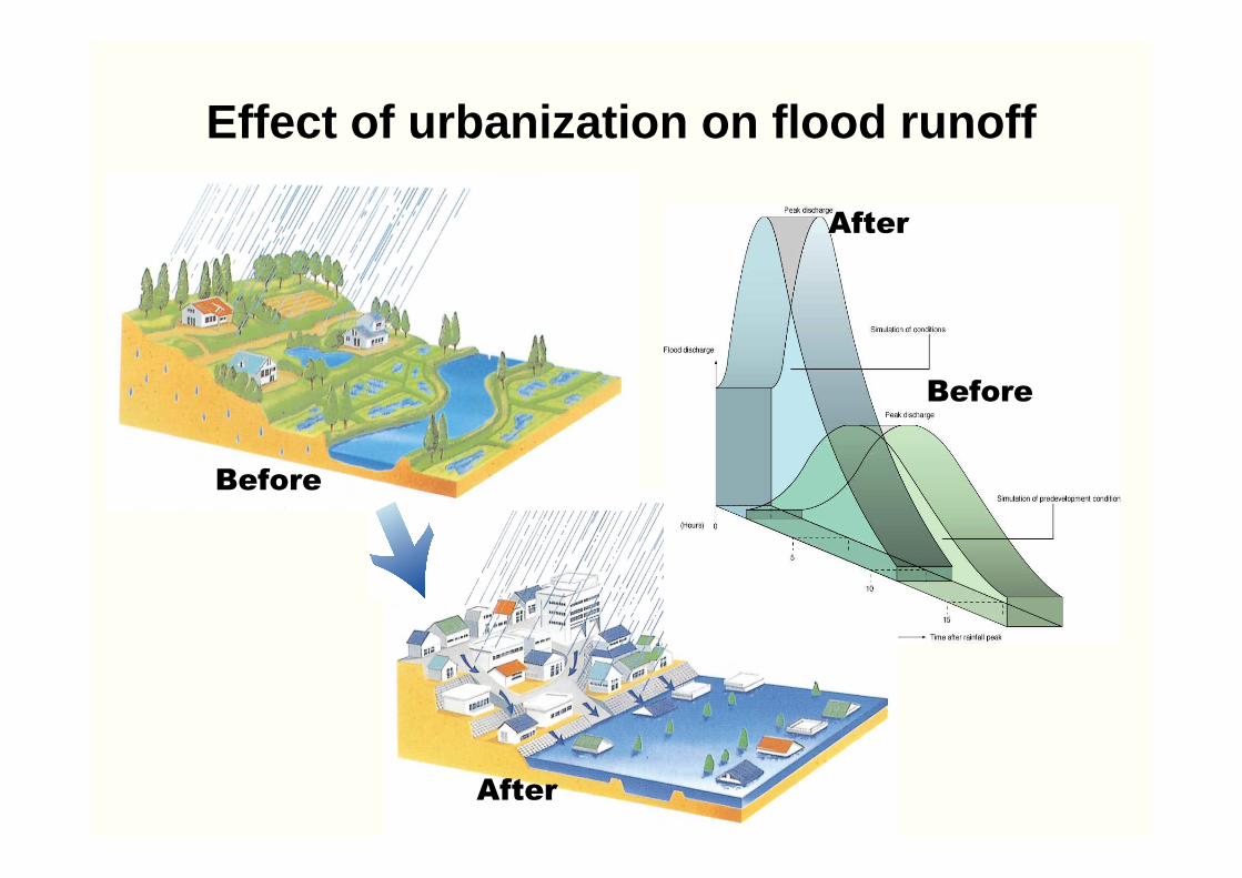
Effect of urbanization on flood runoff

Tsurumi River Naka River and Ayase River
出典:『鶴見川とその流域の再生鶴見川流域水マスタープラン策定に向けた提言』
出典:パンフレット『水害から私たちのまちを守るためには…』
Widening of river channel is difficult in the highly urbanized areaWidening of river channel is difficult in Widening of river channel is difficult in the highly urbanized areathe highly urbanized area
Source: “Tsurumi River and Renewal of Its Basin –Suggestions toward Formulation of Master Plan for Development of Tsurumi River Basin Water Resources”
Source: Brochure “For Prptecing Our Town from Flood Disasters”
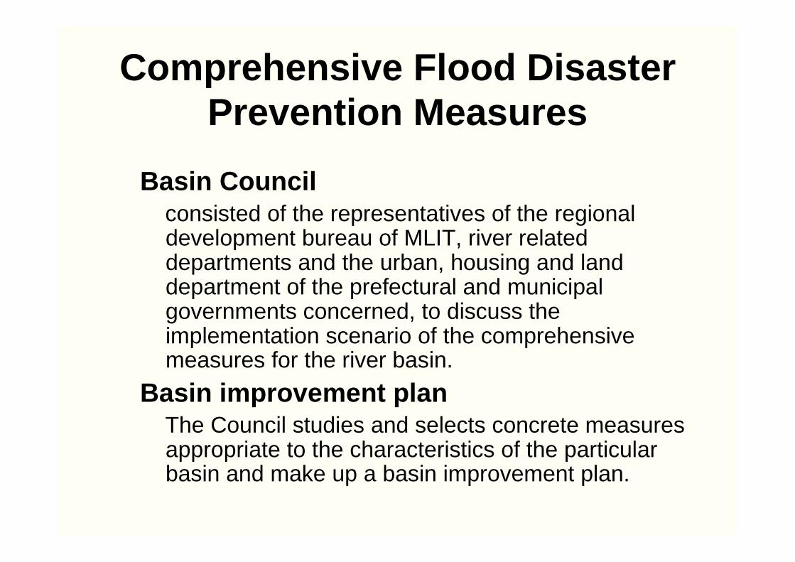
Comprehensive Flood Disaster Prevention Measures
Basin Councilconsisted of the representatives of the regional development bureau of MLIT, river related departments and the urban, housing and land department of the prefectural and municipal governments concerned, to discuss the implementation scenario of the comprehensive measures for the river basin.
Basin improvement planThe Council studies and selects concrete measures appropriate to the characteristics of the particular basin and make up a basin improvement plan.
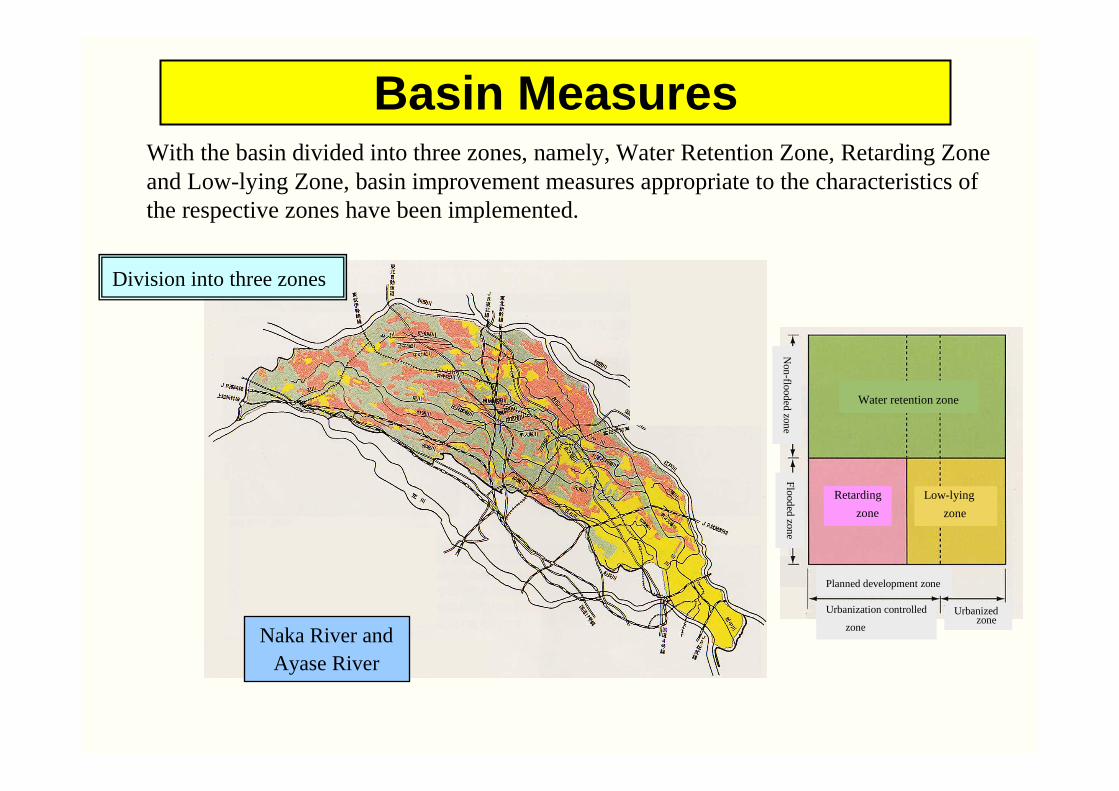
Basin MeasuresWith the basin divided into three zones, namely, Water Retention Zone, Retarding Zone and Low-lying Zone, basin improvement measures appropriate to the characteristics of the respective zones have been implemented.
Naka River and Ayase River
Division into three zones
Non
-flooded
zone
Flood
ed zon
e
Water retention zone
Retarding
zone
Low-lying
zone
Planned development zone
Urbanization controlled
zone
Urbanizedzone
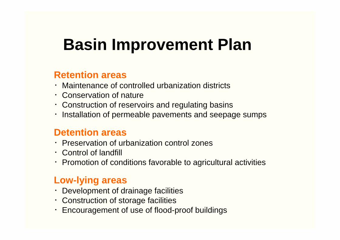
Retention areas・Maintenance of controlled urbanization districts・Conservation of nature・Construction of reservoirs and regulating basins・Installation of permeable pavements and seepage sumps
Detention areas・Preservation of urbanization control zones・Control of landfill・Promotion of conditions favorable to agricultural activities
Low-lying areas・Development of drainage facilities・Construction of storage facilities・Encouragement of use of flood-proof buildings
Basin Improvement Plan
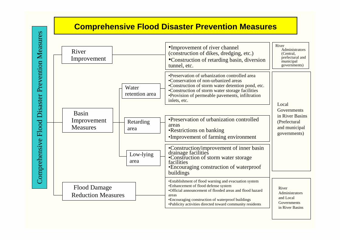
Comprehensive Flood Disaster Prevention Measures
総
合
治
水
対
策
害 策
Water retention area
Retarding area
Low-lying area
•Improvement of river channel (construction of dikes, dredging, etc.) •Construction of retarding basin, diversion tunnel, etc.
•Preservation of urbanization controlled area •Conservation of non-urbanized areas•Construction of storm water detention pond, etc.•Construction of storm water storage facilities•Provision of permeable pavements, infiltration inlets, etc.
•Preservation of urbanization controlled areas•Restrictions on banking•Improvement of farming environment
•Construction/improvement of inner basin drainage facilities•Construction of storm water storage facilities•Encouraging construction of waterproof buildings•Establishment of flood warning and evacuation system•Enhancement of flood defense system•Official announcement of flooded areas and flood hazard areas•Encouraging construction of waterproof buildings•Publicity activities directed toward community residents
Local Governments in River Basins (Prefecturaland municipal governments)
RiverAdministratorsand Local Governments in River Basins
Com
pre
hens
ive
Flo
od D
isa
ste
r P
reve
ntio
n M
ea
sure
s
Basin Improvement Measures
Flood Damage Reduction Measures
River Improvement
River Administrators (Central, prefectural and municipal governments)

Example of Basin Measures
Multipurpose Retarding Basin for Tsurumi River
Construction of Retarding Basin and Diversion Tunnel
Retarding basin Tsurumi River
Yokohama International General Athletic Stadium
Dike Overflow type dike Dike
Ove
rflo
w t
ype
dik
e
Tsur
umi R
iver

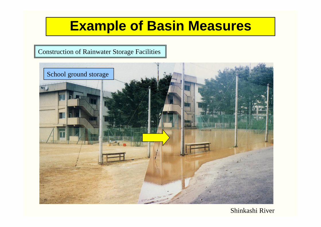
Example of Basin Measures
School ground storage
Shinkashi River
Construction of Rainwater Storage Facilities

Example of Basin Measures
Permeable pavement Permeable tile pavement
Tokyo Metropolis
Construction of Permeable Pavements and Infiltration Inlets
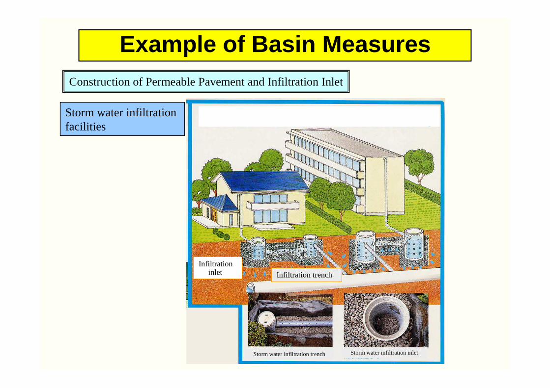
Example of Basin Measures
Storm water infiltration facilities
Construction of Permeable Pavement and Infiltration Inlet
Infiltration inlet Infiltration trench
Storm water infiltration trench Storm water infiltration inlet
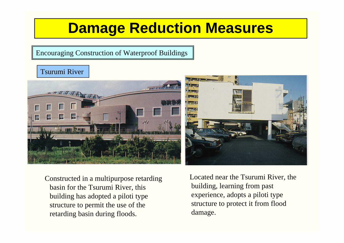
Damage Reduction Measures
Located near the Tsurumi River, the building, learning from past experience, adopts a piloti type structure to protect it from flood damage.
Tsurumi River
Encouraging Construction of Waterproof Buildings
Constructed in a multipurpose retarding basin for the Tsurumi River, this building has adopted a piloti type structure to permit the use of the retarding basin during floods.

Role of flood hazard map
1.Advance preparation1.Advance preparation 2. 2. Damage mitigation in the event of a disasterDamage mitigation in the event of a disaster
3. 3. Increasing awareness of disaster preventionIncreasing awareness of disaster prevention
Flood hazard map of X city
Communication channel of information
Distribution of
underground space
Hints / possessions on evacuation
Flood-predicted area, flooded depth manifested
Contact information-Administrative agency-Medical institution-Lifeline administrator
Location / name of evacuation site
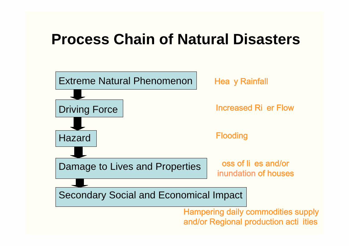
Process Chain of Natural Disasters
Extreme Natural Phenomenon
Driving Force
Hazard
Damage to Lives and Properties
Secondary Social and Economical Impact
Hea y RainfallHea y RainfallHea y RainfallHea y Rainfall
Increased Ri er FlowIncreased Ri er FlowIncreased Ri er FlowIncreased Ri er Flow
FloodingFloodingFloodingFlooding
oss of li es and/or oss of li es and/or oss of li es and/or oss of li es and/or inundationinundationinundationinundation of housesof housesof housesof houses
Hampering daily commodities supply Hampering daily commodities supply Hampering daily commodities supply Hampering daily commodities supply and/or Regional production acti itiesand/or Regional production acti itiesand/or Regional production acti itiesand/or Regional production acti ities
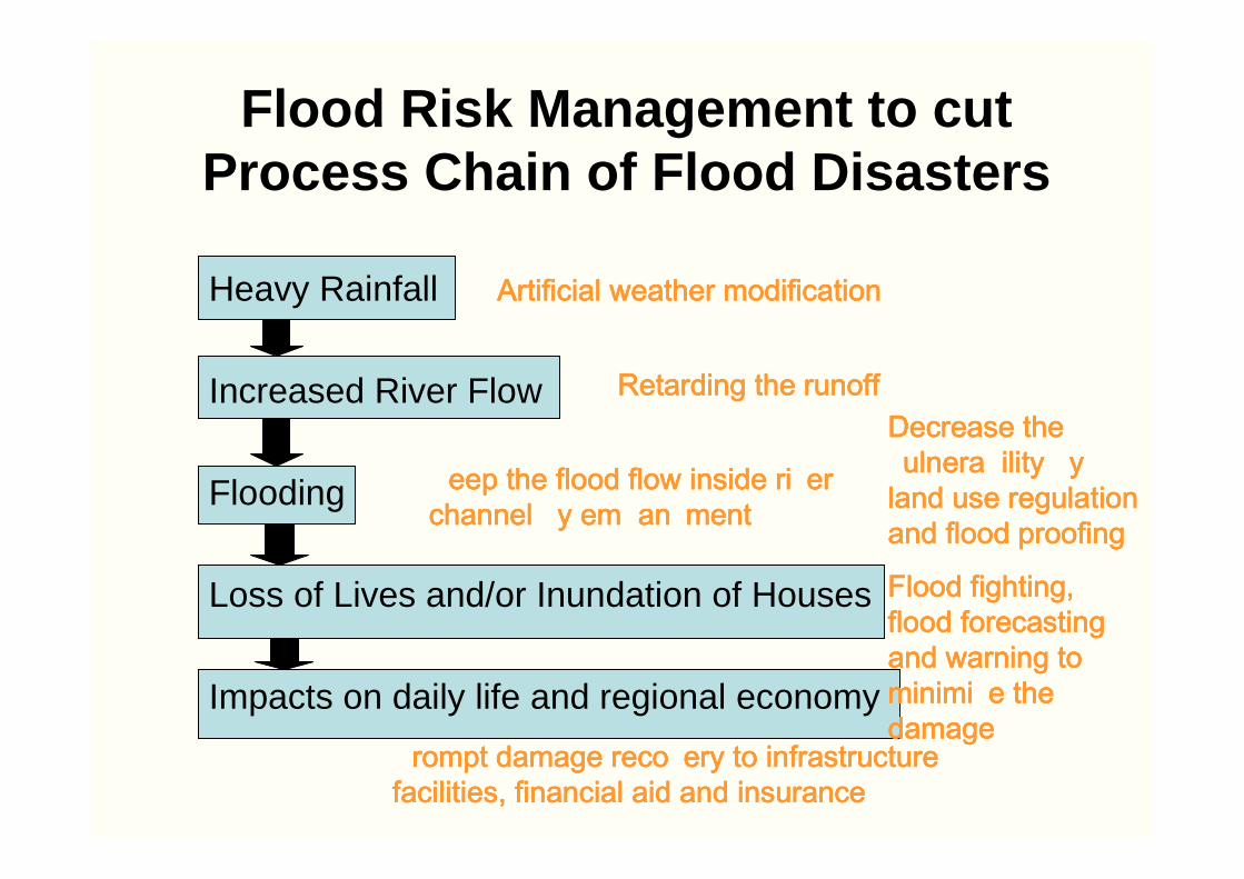
Flood Risk Management to cut Process Chain of Flood Disasters
Heavy Rainfall
Increased River Flow
Flooding
Loss of Lives and/or Inundation of Houses
Impacts on daily life and regional economy
Artificial weather modificationArtificial weather modificationArtificial weather modificationArtificial weather modification
Retarding the runoffRetarding the runoffRetarding the runoffRetarding the runoff
eep the flood flow inside ri er eep the flood flow inside ri er eep the flood flow inside ri er eep the flood flow inside ri er channel y em an mentchannel y em an mentchannel y em an mentchannel y em an ment
Decrease the Decrease the Decrease the Decrease the ulnera ility y ulnera ility y ulnera ility y ulnera ility y
land use regulation land use regulation land use regulation land use regulation and flood proofingand flood proofingand flood proofingand flood proofing
Flood fighting, Flood fighting, Flood fighting, Flood fighting, flood forecasting flood forecasting flood forecasting flood forecasting and warning to and warning to and warning to and warning to minimi e the minimi e the minimi e the minimi e the damagedamagedamagedamage
rompt damage reco ery to infrastructure rompt damage reco ery to infrastructure rompt damage reco ery to infrastructure rompt damage reco ery to infrastructure facilities, financial aid and insurancefacilities, financial aid and insurancefacilities, financial aid and insurancefacilities, financial aid and insurance
ENDENDThank you for your attention
http://www.icharm.pwri.go.jp


