Towards a real-time aerial image mosaicing solution Alexander Kern * , Markus Bobbe and Ulf Bestmann TU Braunschweig, Germany ABSTRACT Real-time aerial image mosaicing is a crucial task for future search and rescue missions. Solv- ing the correspondence problem, estimating a valid transformation and visualizing the result is computational intensive. It becomes more chal- lenging if the flying platform is a small micro air vehicle (MAV), which limits the available mar- gin for payload significantly. This paper proposes a robust algorithm that is able to create and update photo maps in a fixed period of time. The approach uses a high num- ber of features and strict match filtering to allow robust matching without additional sensor infor- mation. Subsequently the ability of todays most common single board computers (SBC) to run the presented algorithm is examined. Together with the selection of a lightweight board camera the setup is less than 100 grams allowing even small MAVs to generate maps in real-time. 1 I NTRODUCTION In recent years the development of unmanned aircrafts considerably reduced the costs and effort required to gener- ate aerial images. As a result aerial mapping is getting more common in various fields such as agriculture or construc- tion side documentation. Common mapping results are 2D pseudo-orthophotos and 3D surface meshes. Both are com- monly generated using structure from motion or photogram- metry workflows which are started after the survey flight and usually take several hours. The capability for cost and time efficient aerial map- ping is also needed by various emergency response units. In civil catastrophe scenarios for instance after earthquakes or tsunamis these maps can be used by rescue workers to get an overview of the situation. While a 3D mesh of the area gener- ated by structure from motion or photogrammetry can fulfill the need for an all around perspective at best, it is compu- tationally intensive and therefore too time consuming. Cer- tainly time is of critical importance to maintain an effective coordination of the emergency aid to save human lifes. This paper aims to provide a solution for a 2D real-time mapping implementation. In its first half a suitable mosaicing algorithm is discussed and presented. Afterwards the hard- ware requirements are determined and compared to hardware * contact: [email protected]available today. The ultimate goal is to create a lightweight standalone package capable of performing the image acquisi- tion and mapping task independently from the aerial vehicle it is attached to. Figure 1: General approach to image mosaicing. 2 REAL- TIME CAPABLE MOSAICING ALGORITHM In this section the focus lies on the algorithms used for image mosaicing. The choice is highly influenced by the requirements emerging from real-time performance. While classic approaches use bundle adjustment to minimize the re- projection error over all images in a single, iterative step to get a global consistent solution, it is not feasible for real-time applications. The computational time is too high and will increase with every image taken as the complexity increases with O((m + n) 3 ), where m is the number of images and n is the number of structure points [1]. The real-time performance imposes the requirement of a constant maximum time frame for every stitching iteration. This time frame has to be inde- pendent from the number of images that have already been taken. To allow such performance the extensive OpenCV 3.0 C++ library is well suited and is therefore used for this task. 1
Transcript
Towards a real-time aerial image mosaicing solutionAlexander Kern∗, Markus Bobbe and Ulf Bestmann
TU Braunschweig, Germany
ABSTRACT
Real-time aerial image mosaicing is a crucialtask for future search and rescue missions. Solv-ing the correspondence problem, estimating avalid transformation and visualizing the result iscomputational intensive. It becomes more chal-lenging if the flying platform is a small micro airvehicle (MAV), which limits the available mar-gin for payload significantly.
This paper proposes a robust algorithm that isable to create and update photo maps in a fixedperiod of time. The approach uses a high num-ber of features and strict match filtering to allowrobust matching without additional sensor infor-mation. Subsequently the ability of todays mostcommon single board computers (SBC) to runthe presented algorithm is examined. Togetherwith the selection of a lightweight board camerathe setup is less than 100 grams allowing evensmall MAVs to generate maps in real-time.
1 INTRODUCTION
In recent years the development of unmanned aircraftsconsiderably reduced the costs and effort required to gener-ate aerial images. As a result aerial mapping is getting morecommon in various fields such as agriculture or construc-tion side documentation. Common mapping results are 2Dpseudo-orthophotos and 3D surface meshes. Both are com-monly generated using structure from motion or photogram-metry workflows which are started after the survey flight andusually take several hours.
The capability for cost and time efficient aerial map-ping is also needed by various emergency response units. Incivil catastrophe scenarios for instance after earthquakes ortsunamis these maps can be used by rescue workers to get anoverview of the situation. While a 3D mesh of the area gener-ated by structure from motion or photogrammetry can fulfillthe need for an all around perspective at best, it is compu-tationally intensive and therefore too time consuming. Cer-tainly time is of critical importance to maintain an effectivecoordination of the emergency aid to save human lifes.
This paper aims to provide a solution for a 2D real-timemapping implementation. In its first half a suitable mosaicingalgorithm is discussed and presented. Afterwards the hard-ware requirements are determined and compared to hardware
available today. The ultimate goal is to create a lightweightstandalone package capable of performing the image acquisi-tion and mapping task independently from the aerial vehicleit is attached to.
Figure 1: General approach to image mosaicing.
2 REAL-TIME CAPABLE MOSAICING ALGORITHM
In this section the focus lies on the algorithms used forimage mosaicing. The choice is highly influenced by therequirements emerging from real-time performance. Whileclassic approaches use bundle adjustment to minimize the re-projection error over all images in a single, iterative step toget a global consistent solution, it is not feasible for real-timeapplications. The computational time is too high and willincrease with every image taken as the complexity increaseswithO((m+n)3), wherem is the number of images and n isthe number of structure points [1]. The real-time performanceimposes the requirement of a constant maximum time framefor every stitching iteration. This time frame has to be inde-pendent from the number of images that have already beentaken. To allow such performance the extensive OpenCV 3.0C++ library is well suited and is therefore used for this task.
1
2.1 Feature Extraction
In figure 1 the general approach for image mosaicing isdisplayed. As soon as a new image is acquired and sent tothe pipeline, the first step is initiated. This step combines de-tection of markable points and description of the pixels nearenvironment. For this task the ORB algorithm is used. Itis based on the FAST keypoint detector and the BRIEF de-scription of these keypoints [2]. The fact ORB uses a binarydescriptor allows very efficient logical operations and com-parisons, which fits the need for a real-time capable systemexcellently.
2.2 Feature Matching
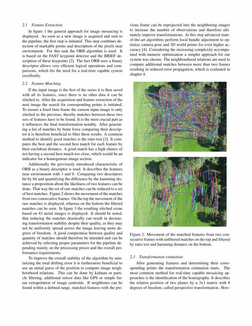
If the input image is the first of the series it is then savedwith all its features, since there is no other data it can bestitched to. After the acquisition and feature extraction of thenext image the search for corresponding points is initiated.To ensure a fixed time frame the current input image is onlystitched to the previous, thereby matches between these twosets of features have to be found. It is the most crucial part asit influences the final transformation notably. After generat-ing a list of matches by brute force comparing their descrip-tor it is therefore beneficial to filter these results. A commonmethod to identify good matches is the ratio test [3]. It com-pares the best and the second best match for each feature bytheir euclidean distance. A good match has a high chance ofnot having a second best match too close, which would be anindicator for a homogenous image section.
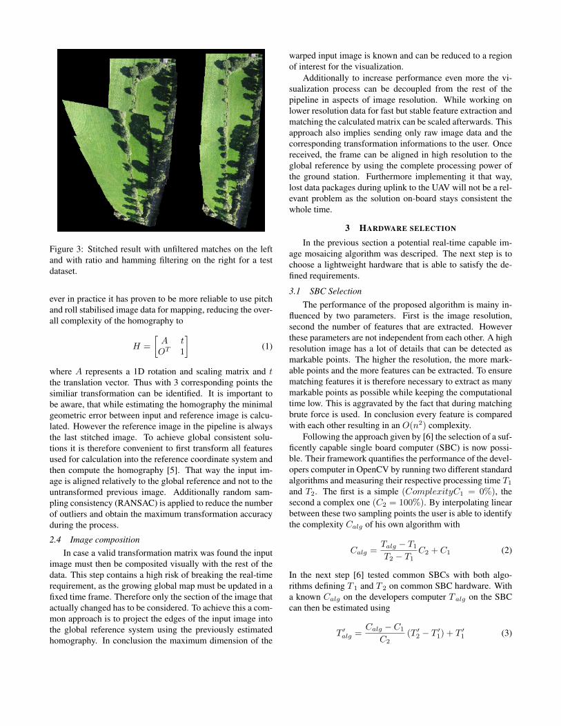
Additionally the previously introduced characteristic ofORB as a binary descriptor is used. It describes the featuresnear environment with 1 and 0. Comparing two descriptorsbit by bit and quantifying the difference by the hamming dis-tance a proposition about the likeliness of two features can bedone. That way the set of raw matches can be reduced to a setof best matches. Figure 2 shows the movement of the matchesfrom two consecutive frames. On the top the movement of theraw matches is displayed, whereas on the bottom the filteredmatches can be seen. In figure 3 the resulting stitched scenebased on 43 aerial images is displayed. It should be noted,that reducing the matches drastically can result in decreas-ing transformation stability despite their quality, as they maynot be uniformly spread across the image leaving more de-grees of freedom. A good compromise between quality andquantity of matches should therefore be intended and can beachieved by selecting proper parameters for the pipeline de-pending mainly on the processing power and the overall per-formance requirements.
To improve the overall stability of the algorithm by min-imizing the total drifting error it is furthermore beneficial touse an initial guess of the position to compute image neigh-boorhood relations. This can be done by kalman or parti-cle filtering, additional sensor data like GPS or simple lin-ear extrapolation of image centroids. If neighbours can befound within a defined range, matched features with the pre-
vious frame can be reprojected into the neighboring imagesto increase the number of observations and therefore ulti-mately improve transformations. At this step advanced state-of-the-art algorithms perform local bundle adjustment to op-timize camera pose and 3D world points for even higher ac-curacy [4]. Considering the increasing complexity accompa-nied with numeric optimization a simpler approach for oursystem was chosen. The neighbourhood relations are used tocompute additional matches between more than two framesresulting in reduced error propagation, which is evaluated inchapter 4.
Figure 2: Movement of the matched features from two con-secutive frames with unfiltered matches on the top and filteredby ratio test and hamming distance on the bottom.
2.3 Transformation estimation
After generating features and determining their corre-sponding points the transformation estimation starts. Themost common method for real-time capable mosaicing ap-proaches is the identification of the homography. It describesthe relative position of two planes by a 3x3 matrix with 8degrees of freedom, called perspective transformation. How-
Figure 3: Stitched result with unfiltered matches on the leftand with ratio and hamming filtering on the right for a testdataset.
ever in practice it has proven to be more reliable to use pitchand roll stabilised image data for mapping, reducing the over-all complexity of the homography to
H =
[A tOT 1
](1)
where A represents a 1D rotation and scaling matrix and tthe translation vector. Thus with 3 corresponding points thesimiliar transformation can be identified. It is important tobe aware, that while estimating the homography the minimalgeometric error between input and reference image is calcu-lated. However the reference image in the pipeline is alwaysthe last stitched image. To achieve global consistent solu-tions it is therefore convenient to first transform all featuresused for calculation into the reference coordinate system andthen compute the homography [5]. That way the input im-age is aligned relatively to the global reference and not to theuntransformed previous image. Additionally random sam-pling consistency (RANSAC) is applied to reduce the numberof outliers and obtain the maximum transformation accuracyduring the process.
2.4 Image compositionIn case a valid transformation matrix was found the input
image must then be composited visually with the rest of thedata. This step contains a high risk of breaking the real-timerequirement, as the growing global map must be updated in afixed time frame. Therefore only the section of the image thatactually changed has to be considered. To achieve this a com-mon approach is to project the edges of the input image intothe global reference system using the previously estimatedhomography. In conclusion the maximum dimension of the
warped input image is known and can be reduced to a regionof interest for the visualization.
Additionally to increase performance even more the vi-sualization process can be decoupled from the rest of thepipeline in aspects of image resolution. While working onlower resolution data for fast but stable feature extraction andmatching the calculated matrix can be scaled afterwards. Thisapproach also implies sending only raw image data and thecorresponding transformation informations to the user. Oncereceived, the frame can be aligned in high resolution to theglobal reference by using the complete processing power ofthe ground station. Furthermore implementing it that way,lost data packages during uplink to the UAV will not be a rel-evant problem as the solution on-board stays consistent thewhole time.
3 HARDWARE SELECTION
In the previous section a potential real-time capable im-age mosaicing algorithm was descriped. The next step is tochoose a lightweight hardware that is able to satisfy the de-fined requirements.
3.1 SBC SelectionThe performance of the proposed algorithm is mainy in-
fluenced by two parameters. First is the image resolution,second the number of features that are extracted. Howeverthese parameters are not independent from each other. A highresolution image has a lot of details that can be detected asmarkable points. The higher the resolution, the more mark-able points and the more features can be extracted. To ensurematching features it is therefore necessary to extract as manymarkable points as possible while keeping the computationaltime low. This is aggravated by the fact that during matchingbrute force is used. In conclusion every feature is comparedwith each other resulting in an O(n2) complexity.
Following the approach given by [6] the selection of a suf-ficently capable single board computer (SBC) is now possi-ble. Their framework quantifies the performance of the devel-opers computer in OpenCV by running two different standardalgorithms and measuring their respective processing time T1and T2. The first is a simple (ComplexityC1 = 0%), thesecond a complex one (C2 = 100%). By interpolating linearbetween these two sampling points the user is able to identifythe complexity Calg of his own algorithm with
Calg =Talg − T1T2 − T1
C2 + C1 (2)
In the next step [6] tested common SBCs with both algo-rithms defining T 1 and T 2 on common SBC hardware. Witha known Calg on the developers computer T alg on the SBCcan then be estimated using
T ′alg =Calg − C1
C2(T ′2 − T ′1) + T ′1 (3)
Table 1 shows the resulting processing performance of theproposed mosaicing algorithm with a working resolution of480 x 360 pixels and roughly 500 extracted features per im-age on different SBCs. Furthermore table 2 shows the spec-ifications of the boards allowing to choose the best match-ing component concerning size and weight. Overall the Brixboard is the best compromise by performance and weight. Italso outperforms the Intel NUC while being less than half asheavy. However considering the goal of a very lightweightsetup the Odroid XU3 offers the best solution. In our finalssystem an Odroid XU4 was selected as it comes with the sameprocessing hardware but less periphery.
Board Estimated fpsITX i7 31.3Brix 53.5NUC 43.3Odroid XU3 12.3Odroid U3 8.1ITX atom 9.3Jetson 6.6Rasp. Pi B 0.6
Table 1: Processing performance for the proposed algorithmwith different SBCs [7].
3.2 Camera specificationsAt first it is important to determine the general mission
requirements. In an emergency aid scenario a human shouldbe indentifiable on the aerial images. Therefore a resolutionof 5 pixels per 30 cm should at least be maintained resulting ina ground sampling distance (GSD) of 6 cm / pixel. Taking theimage resolution defined in section 3.1 into account this leadsto an image ground dimension of 28.8 x 21.6 m. The vehicleoperation altitude can vary but was chosen to be at least 30 mto prevent collisions with high trees or other obsticles.
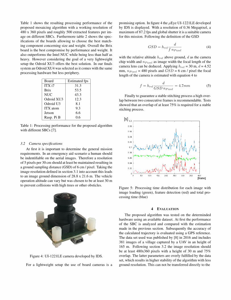
Figure 4: UI-1221LE camera developed by IDS.
For a lightweight setup the use of board cameras is a
promising option. In figure 4 the µEye UI-1221LE developedby IDS is displayed. With a resolution of 0.36 Megapixel, amaximum of 87.2 fps and global shutter it is a suitable camerafor this mission. Following the definition of the GSD
GSD = hreld
f nPixel(4)
with the relative altitude hrel above ground, d as the camerachip width and nPixel as image width the focal length of thecamera lens can be deduced. Applying hrel = 30 m, d = 4.52mm, nPixel = 480 pixels and GSD = 6 cm / pixel the focallength of the camera is estimated with equation 4 to
f = hreld
GSD nPixel= 4.7mm (5)
Finally to guarantee a stable stitching process a high over-lap between two consecutive frames is recommendable. Testsshowed that an overlap of at least 75% is required for a stablestiching process.
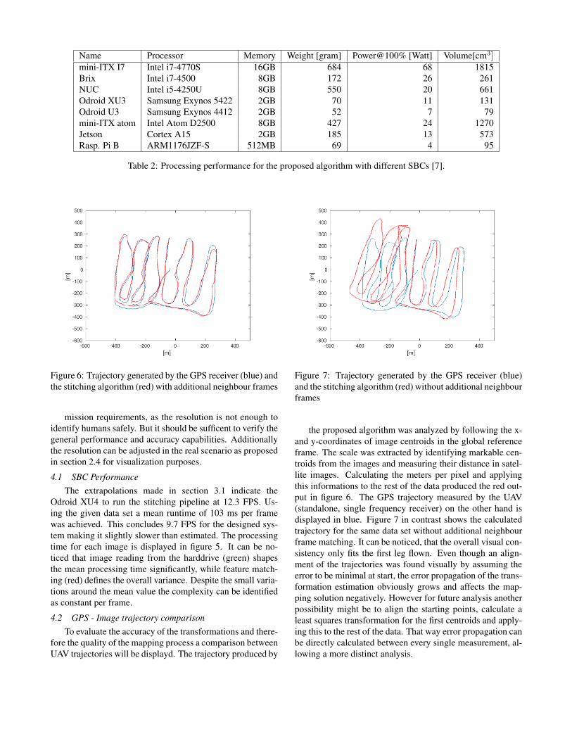
Figure 5: Processing time distribution for each image withimage loading (green), feature detection (red) and total pro-cessing time (blue)
4 EVALUATION
The proposed algorithm was tested on the determindedhardware using an available dataset. At first the performanceof the SBC is analyzed and compared with the estimationmade in the previous section. Subsequently the accuracy ofthe calculated trajectory is evaluated using a GPS reference.The data set used was published by [8] in 2016 and includes381 images of a village captured by a UAV in an height of165 m. Following section 3.2 the image resolution shouldbe at least 480x360 pixels with a height of 30 m and 75%overlap. The latter parameters are overly fulfilled by the dataset, which results in higher stability of the algorithm with lessground resolution. This can not be transferred directly to the
Table 2: Processing performance for the proposed algorithm with different SBCs [7].
Figure 6: Trajectory generated by the GPS receiver (blue) andthe stitching algorithm (red) with additional neighbour frames
mission requirements, as the resolution is not enough toidentify humans safely. But it should be sufficent to verify thegeneral performance and accuracy capabilities. Additionallythe resolution can be adjusted in the real scenario as proposedin section 2.4 for visualization purposes.
4.1 SBC PerformanceThe extrapolations made in section 3.1 indicate the
Odroid XU4 to run the stitching pipeline at 12.3 FPS. Us-ing the given data set a mean runtime of 103 ms per framewas achieved. This concludes 9.7 FPS for the designed sys-tem making it slightly slower than estimated. The processingtime for each image is displayed in figure 5. It can be no-ticed that image reading from the harddrive (green) shapesthe mean processing time significantly, while feature match-ing (red) defines the overall variance. Despite the small varia-tions around the mean value the complexity can be identifiedas constant per frame.
4.2 GPS - Image trajectory comparisonTo evaluate the accuracy of the transformations and there-
fore the quality of the mapping process a comparison betweenUAV trajectories will be displayd. The trajectory produced by
Figure 7: Trajectory generated by the GPS receiver (blue)and the stitching algorithm (red) without additional neighbourframes
the proposed algorithm was analyzed by following the x-and y-coordinates of image centroids in the global referenceframe. The scale was extracted by identifying markable cen-troids from the images and measuring their distance in satel-lite images. Calculating the meters per pixel and applyingthis informations to the rest of the data produced the red out-put in figure 6. The GPS trajectory measured by the UAV(standalone, single frequency receiver) on the other hand isdisplayed in blue. Figure 7 in contrast shows the calculatedtrajectory for the same data set without additional neighbourframe matching. It can be noticed, that the overall visual con-sistency only fits the first leg flown. Even though an align-ment of the trajectories was found visually by assuming theerror to be minimal at start, the error propagation of the trans-formation estimation obviously grows and affects the map-ping solution negatively. However for future analysis anotherpossibility might be to align the starting points, calculate aleast squares transformation for the first centroids and apply-ing this to the rest of the data. That way error propagation canbe directly calculated between every single measurement, al-lowing a more distinct analysis.
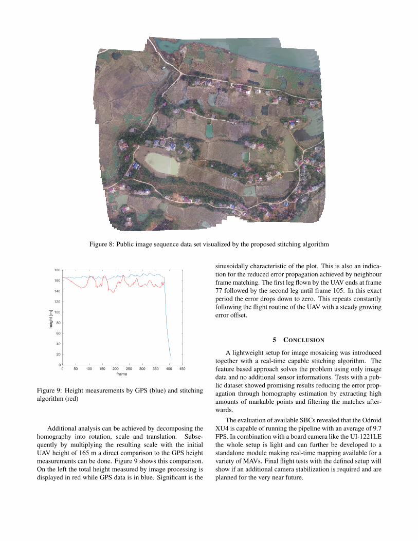
Figure 8: Public image sequence data set visualized by the proposed stitching algorithm
0 50 100 150 200 250 300 350 400 450
frame
0
20
40
60
80
100
120
140
160
180
he
igh
t [m
]
Figure 9: Height measurements by GPS (blue) and stitchingalgorithm (red)
Additional analysis can be achieved by decomposing thehomography into rotation, scale and translation. Subse-quently by multiplying the resulting scale with the initialUAV height of 165 m a direct comparison to the GPS heightmeasurements can be done. Figure 9 shows this comparison.On the left the total height measured by image processing isdisplayed in red while GPS data is in blue. Significant is the
sinusoidally characteristic of the plot. This is also an indica-tion for the reduced error propagation achieved by neighbourframe matching. The first leg flown by the UAV ends at frame77 followed by the second leg until frame 105. In this exactperiod the error drops down to zero. This repeats constantlyfollowing the flight routine of the UAV with a steady growingerror offset.
5 CONCLUSION
A lightweight setup for image mosaicing was introducedtogether with a real-time capable stitching algorithm. Thefeature based approach solves the problem using only imagedata and no additional sensor informations. Tests with a pub-lic dataset showed promising results reducing the error prop-agation through homography estimation by extracting highamounts of markable points and filtering the matches after-wards.
The evaluation of available SBCs revealed that the OdroidXU4 is capable of running the pipeline with an average of 9.7FPS. In combination with a board camera like the UI-1221LEthe whole setup is light and can further be developed to astandalone module making real-time mapping available for avariety of MAVs. Final flight tests with the defined setup willshow if an additional camera stabilization is required and areplanned for the very near future.
REFERENCES
[1] Kaushik Mitra and Rama Chellappa. A scalable projec-tive bundle adjustment algorithm using the l infinty norm.Sixth Indian Conference on Computer Vision, GraphicsImage Processing, 2008.
[2] Ethan Rublee, Vincent Rabaud, Kurt Konolige, and GaryBradski. Orb: an efficient alternative to sift or surf. 2011International Conference on Computer Vision, 2011.
[3] David G. Lowe. Distinctive image features from scale-invariant keypoints. International Journal of ComputerVision, 2004.
[4] Montiel J. M. M. Mur-Artal, Raul and Juan D. Tardos.ORB-SLAM: a versatile and accurate monocular SLAMsystem. IEEE Transactions on Robotics, 31(5):1147–1163, 2015.
[5] Taygun Kekec, Alper Yildrim, and Mustafa Unel. Anew approach to real-time mosaicing of aerial images.Robotics and Autonomous Systems, 62:1755–1767, 2014.
[6] Dries Hulens, Jon Verbeke, and Toon Goedem. How tochoose the best embedded processing platform for on-board uav image processing? VISSAPP 2015, 2015.


![Robust Outliers Detection in Image Point Matching · 1. Introduction 1.1. Motivations and context Image registration has many applications such as stere-ovision [ 18 ], mosaicing](https://static.documents.pub/doc/80x56/5f73c47abbff0b61bc522f5b/robust-outliers-detection-in-image-point-matching-1-introduction-11-motivations.jpg)


