Towards an improved understanding of flood extremes Prof Hannah Cloke Director of Hydrology, University of Reading FRIEND WATER – Floods theme coordinator [email protected]Newcastle, UK, 28 June 2012
Transcript
Towards an improved understanding of flood extremes
A global hydrological research network program that
aims at:
- improving water science
- sustainable use of current and future water resources
- running for over 25 years.
UNESCO IHP-VIII FRIEND-Water programme
FRIEND-Water goals are achieved through:
collecting and exchanging river flow and other hydrological data, particularly in an
international context
enhancing scientific understanding of hydrological processes across scales from
local up to global
developing innovative analytical tools for further improvement of water resource
management and reduction of hydrohazards’ risk (floods and droughts)
educating and developing capacity building pathways through PhD and MSc
courses and technical training courses
disseminating knowledge in publications, books, conferences, workshops and
cooperating with other international networks and professional organizations
UNESCO IHP-VIII FRIEND-Water programme
FRIEND - Global Geographical Coverage
UNESCO IHP-VIII FRIEND-Water programme
FRIEND Water Themes
Techniques:
• satellite data assimilation
• uncertainty representation
UNESCO IHP-VIII FRIEND-Water programme
Making a difference to flood preparedness: operational use of ensembles
Stephens E & Cloke HL (2014) Improving flood forecasts for better flood preparedness in the UK (and beyond) The Geographical Journal doi: 10.1111/geoj.12103
Cloke & Pappenberger (2009) Ensemble flood forecasting: a review. Journal of Hydrology. 375 613-626
Floods in Central Europe June 2013
• EFAS: pioneer of ensemble flood forecasts
• June 2013, EFAS warnings and alerts were issued for all major rivers in central Europe(Elbe, Danube, Rhine) upto 8 days in advance
Pappenberger et al (2011) The impact of weather forecast improvements on large scale hydrology: analysing a decade of forecasts. Hydrological Processes. 25: 7
The image shows the EFAS multi-model streamflow prediction for Passau, Germany. Forecast date is 30/05/2013 12 UTC. The colours indicate the different alert levels.
The box plots show the ECMWF EPS, the red line the ECMWF Highres, the black line the DWD COSMO.
The forecasts gives a clear indication of a flooding in 3-4 days
Somerset Levels, February 2014 This winter (2013/14) coastal storms and an unprecedented amount of rainfall led to significant and widespread flooding across the southern UK.
Stephens E & Cloke HL (2014) Improving flood forecasts for better flood preparedness in the UK (and beyond) The Geographical Journal doi: 10.1111/geoj.12103
UK Winter Floods 2013/2014
Some ensemble systems
implemented. Others in
testing.
2 scenarios shown in the
ensemble surge forecasts;
- Most likely = just crossing
alert thresholds.
- ‘Reasonable worst case’ =
significant surge.
- 7/8 days before event –
early discussions with civil
protection.
Stephens & Cloke (2014) Improving flood forecasts for better flood preparedness in the UK (and beyond) The Geographical Journal doi: 10.1111/geoj.12103
Dale et al (2013) Applying probabilistic flood forecasting in flood incident management. Technical Report. Project SC090032. DEFRA/Environment Agency joint Flood and Coastal Erosion Risk Management Research and Development Programme.
12
71 severe
flood
warnings
Flood Warnings – 6 Dec 14:00
Over
160,000
warning
messages
sent to
homes and
businesses
43000 flood
warnings
issued in 1
hour (6 Dec)
Ensemble forecasts and warnings can only reach their full potential if they are understood and acted upon by the person receiving
Coproduction of warning systems
Demeritt D, Nobert S, Cloke HL, Pappenberger F (2013) The European Flood Alert System (EFAS) and the communication, perception and use of ensemble predictions for operational flood risk management. Hydrological Processes, 27 (1). pp. 147-157.
Wetterhall F, Pappenberger F, Cloke HL et al + 30 authors (2013) Forecasters priorities for improving probabilistic flood forecasts, Hydrology and Earth System Sciences, 17, 4389-4399
Resolution v Representation of uncertainty
Computational cost
Beven, K. J. and H. L. Cloke (2012), Comment on “Hyperresolution global land surface modeling: Meeting a grand challenge for monitoring Earth's terrestrial water” by Eric F. Wood et al., Water Resour. Res., 48, W01801, doi:10.1029/2011WR010982.
Beven et al (in press) Hyperresolution information and hyperresolution ignorance in modelling the hydrology of the land surface. Science China
Assimilating remotely sensed soil moisture into
a hydrological model
Detection of topographic signal in high resolution ASAR data.
Improving initial conditions for hydrological and land surface modelling of FFIR events.
Backscatter over Severn/Avon for (left) dry, (right) wet period (brighter soil = wetter).
Mason et al (in review) Evidence of a topographic signal in surface soil moisture derived from ENVISAT ASAR Wide Swath data. International Journal of Applied Earth Observation and Geoinformation
Earth Observation based flood forecasting:
Assimilating remotely sensed flood water levels
Garcia-Pintado et al (in review) Satellite-supported flood forecasts in river networks. Journal of Hydrology
evaluating the assimilation of WLOs obtained from a sequence of real SAR overpasses (the X-band COSMO-Skymed constellation) with Ensemble Transfer Kalman Filter
Mining of archives.
Hayley Fowler, Stephen Blenkinsop & David Archer: Newcastle University
Hayley Fowler, Stephen Blenkinsop, Geoff Parkin & David Archer: Newcastle University
Improving our evidence base:
Joint archive of flood events and impactsMining newspaper and administrative records
Public-sourced evidence/social media
Dynamic flood levels in Morpeth reconstructed from public-sourced evidence
5pm, 6 Sept 2008
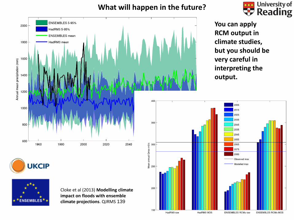
You can apply RCM output in climate studies, but you should be very careful in interpreting the output.
Cloke et al (2013) Modelling climate impact on floods with ensemble climate projections. QJRMS 139