22
Town of Barkhamsted: Amphibian and Reptile Biodiversity Study Metropolitan Conservation Alliance a program of the MCA Technical Paper Series: No. 16
Town of Barkhamsted: Amphibian and Reptile Biodiversity Study
Metropolitan Conservation Alliance
a program of the
MCA Technical Paper Series: No. 16
Town of Barkhamsted: Amphibian and Reptile Biodiversity Study
by
Eric R. Davison, BSc
and
Michael W. Klemens, PhD
Metropolitan Conservation Alliance - A program of the Cary Institute of Ecosystem Studies
Box A-B Millbrook, New York
12545-0129
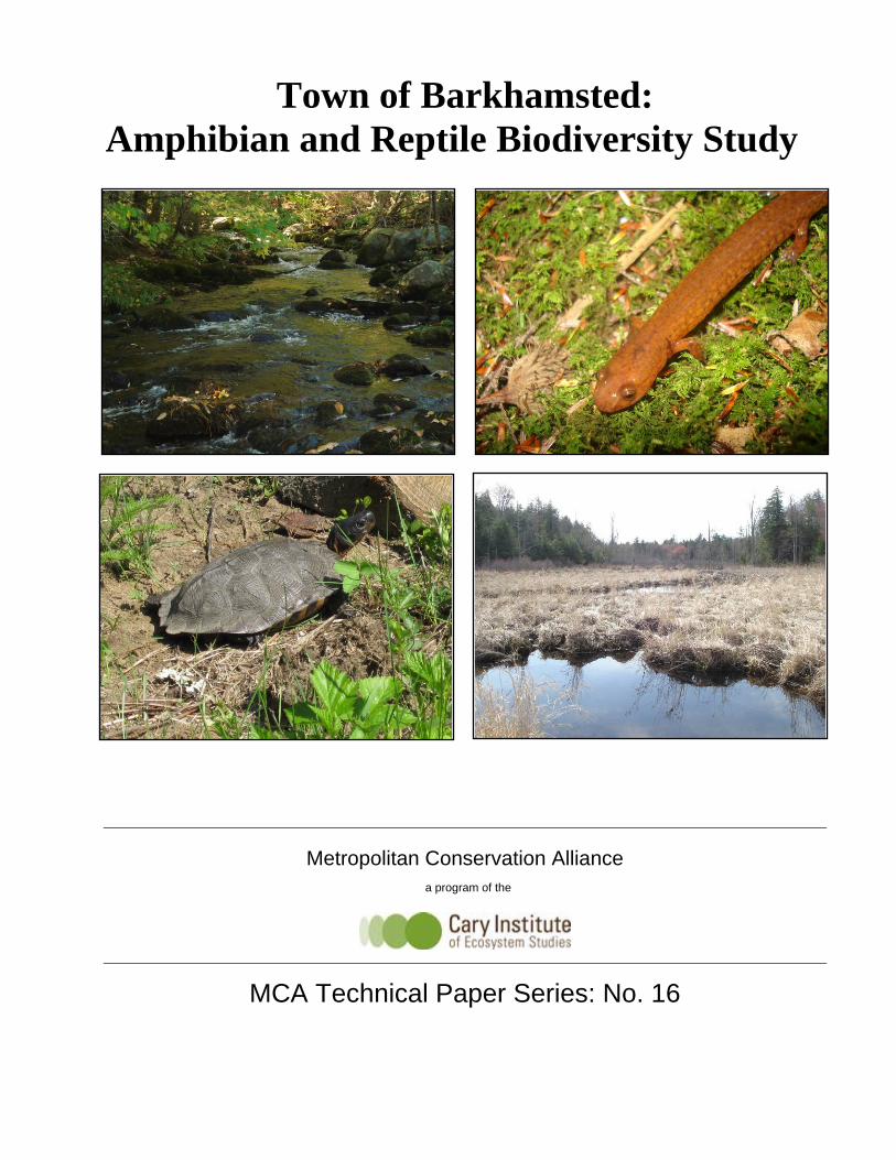
Front cover images: Morgan Brook (top left), Northern Spring Salamander from Morgan Brook (top right), Wood Turtle near Pleasant Valley (bottom left) and Hoyt Hayes Swamp (bottom right).
Suggested citation:
Davison, E.R., and M.W. Klemens. 2011. Town of Barkhamsted Amphibian and Reptile Biodiversity Study. MCA Technical Paper No. 16, Metropolitan Conservation Alliance, Cary Institute of Ecosystem Studies, Millbrook, New York.
Barkhamsted Amphibian & Reptile Biodiversity Study 2010 1 | P a g e
1.0 INTRODUCTION 1.1 Project history This project was funded by a Farmington River Enhancement Grant made by the Connecticut Department of Environmental Protection to the town of Barkhamsted, with additional support provided by a grant from the Field Day Foundation to the Metropolitan Conservation Alliance (MCA), a program of the Cary Institute. The project’s primary focus was to evaluate and incorporate low impact development (LID) standards into the town’s land‐use regulations based on biological information collected by MCA. The project aimed to indentify challenges and opportunities for the conservation of ecological resources and functions as part of this process. Barkhamsted has been working towards revising its regulations to incorporate such practices as private roads and shared driveways, unpaved roads, cluster housing and other practices that can be aligned with LID practices. LID practices aim to reduce the amount of land that is disturbed during the land development process, thereby reducing the negative impacts of development on water quality and quantity. These concepts are consistent with the general goal of retaining Barkhamstedʹs rural character and protecting its valuable water resources. The purpose of the biodiversity study was to identify and map sensitive biological resources. Revisions to the land‐use regulations would then be done in a manner that ensures that they were compatible with these biological resources, that conservation of biodiversity and naturally functioning systems will be an integral part of the regulatory review process and that LID practices would benefit biodiversity. 1.2 Acknowledgements We gratefully acknowledge the citizens of Barkhamsted for their interest and support of this project, and are especially thankful for the landowners who granted permission for us to access their properties for this research. This project was carried out under the aegis of the Barkhamsted LID Committee, chaired by Michael Beauchene. Special thanks are due to First Selectman Don Stein and his staff for their support and technical assistance, including obtaining written permission from landowners to access their properties. Deborah Simon, a member of the LID Committee, participated in the collection of field data, and was invaluable to the success of our efforts. We gratefully acknowledge the financial support of Julia Widdowson through the Field Day Foundation. 1.3 Town information The town of Barkhamsted encompasses approximately 25,000 acres of land located in Connecticut’s Northwest Highlands, a region characterized by narrow valleys and steep ridgelines extending into Connecticut from the Berkshire Mountains of Massachusetts. The town is sparsely developed, with commercial and residential development clustered along
Barkhamsted Amphibian & Reptile Biodiversity Study 2010 2 | P a g e
Route 44 as well as within the villages of Pleasant Valley and Riverton, which lie within the narrow Farmington River valley. The town’s political and socio‐economic center is along the Farmington River’s West Branch, a designated National Wild and Scenic River system. A large proportion of the town’s land mass is owned by public or quasi‐public entities, the State of Connecticut’s Department of Environmental Protection, which operates the American Legion Campground, People’s State Forest, Tunxis State Forest and Ender’s State Forest and the Metropolitan District Commission, which operates two large regional drinking water reservoirs. 2.0 MATERIALS and METHODS
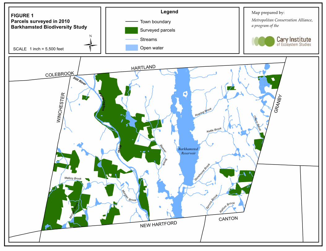
2.1 Study area Landowners throughout town were sent a letter requesting permission for biologists to access their property for the biodiversity survey. The parcels in which access was granted defined the study area. Access was granted on a total of 3,245 acres covering 54 parcels. A total of 46 of these parcels were visited at least once during the survey period. These parcels were scattered throughout the town, however the majority of parcels occur in the town’s southwestern corner (see Figure 1). The rationale for targeting private land was that they contained many headwater wetlands that fed the Farmington River. LID techniques hold great promise for use on these lands to insure that potential future development would not adversely affect downstream water quality. A total of eight parcels in which access was granted were not surveyed; these parcels total approximately 500 acres. These parcels were not surveyed due to the following factors: either they contained no wetlands or potential habitat for critical species; they were contiguous with wetland systems already surveyed on adjacent parcels; or they were deemed unimportant to the overall biodiversity study (e.g., the town transfer station property). The majority of the parcels in which access was granted were located within the southwestern corner of town in the vicinity of West‐West Hill Road, West Hill Road and New Hartford Road. These parcels occur in the Mallory and Morgan Brook Watersheds which drain directly to the Farmington River. 2.2 Field Data Collection MCA biologists conducted field surveys between April and October 2010. Amphibian and reptile survey techniques consisted primarily of visual searches and the turning over of cover objects (logs, rocks, and other debris). These data were augmented by additional species and localities reported in Klemens (1993). Surveys for the Northern Spring Salamander (Gyrinophilus p. porphyriticus) were conducted in suitable streams by carefully searching under rocks within the stream channel or at the stream’s
Barkhamsted Amphibian & Reptile Biodiversity Study 2010 3 | P a g e
banks for adult and larval salamanders. Suitable groundwater seepages were surveyed in the same manner, by carefully searching under rocks and logs. Vernal pools were surveyed by dip‐netting in order to detect larval amphibians, as well as wading and visually searching for amphibian egg masses and larvae. 3.1 Wetland Types A variety of wetland types were surveyed in Barkhamsted, including coniferous and deciduous forested wetlands, groundwater seeps and springs, high‐gradient streams, beaver‐impounded meadows and ponds and major rivers systems such as the Still and Farmington Rivers. The types of wetlands occurring in Barkhamsted are the direct result of the areas rugged terrain. The town consists predominately of glacial till geomorphology. Areas of bedrock outcroppings and shallow to bedrock soils dominate the landscape. The most common wetland type occurring in Barkhamsted is referred to as a “groundwater slope” forested wetlands. Groundwater slope wetlands occur on slopes or hillsides where groundwater discharges to the surface as springs or seeps. Groundwater flow into these wetlands can be continuous or seasonal depending on the local geohydrology and on the evapotranspiration rate of the wetland and adjacent uplands (Mitsch and Gosselink, 2007). Many of these wetlands are forested with Hemlock (Tsuga canadensis) and a dense undergrowth of Mountain Laurel (Kalmia latifolia). The ground’s surface is often blanketed with a dense growth of Sphagnum Moss (Sphagnum spp.) due to the influx of cold groundwater. The sloping topography of many of Barkhamsted’s wetlands makes the hydroperiod a limiting factor with respect to wetland‐dependant wildlife use. Hydroperiod refers to the depth and duration of standing water within a wetland. Because these wetlands occur on slopes and hillsides the hydoperiod is saturated, with only shallow standing water ponding within wetland microtopography. The lack of prolonged standing water makes these wetlands unsuitable for vernal pool amphibians or other species that require open water for breeding or other aspects of their life history. Numerous upper perennial or “headwater” streams occur in Barkhamsted, many of which are fed by perched, forested wetlands. These headwater streams are steeply‐sloping, high‐gradient first and second‐order streams flowing from ridgelines and mountaintops. Examples include Morgan Brook, Cherry Brook and Roaring Brook. These streams are rocky and fast‐flowing, with cold, well‐oxygenated water. Due to the limited extent of development within many of these watersheds, the water in these streams is generally of high‐quality, free of pollutants typically found in more urbanized stream systems. The typical wildlife assemblage of these headwater streams includes the Brook Trout (Salvelinus fontinalis), Northern Dusky (Desmognathus fuscus) and Northern Two‐lined (Eurycea bislineata) Salamanders, crayfish, dace, minnows and less commonly the Northern Spring Salamander (Gyrinophilus porphyriticus) and Slimy Sculpin (Cottus cognatus). Many of these species cannot thrive in streams that have been degraded by sedimentation, pollutants or other impacts
Barkhamsted Amphibian & Reptile Biodiversity Study 2010 4 | P a g e
associated with extensive areas of impervious surfaces, such as stream flashiness and thermal spikes. 3.0 RESULTS The reptiles and amphibians that are known to occur in Barkhamsted based on MCA’s 2010 survey as well as data collected historically by Michael W. Klemens are listed in Table 1. Barkhamstedʹs herpetofauna is typical of that of the upland regions of northwestern Connecticut. Twenty‐four native species consisting of seven salamanders, seven frogs, four turtles, and six snakes have been recorded to date (Klemens, 1993 and MCA 2010 survey). In addition, one introduced turtle species has been recorded (MCA 2010 survey). Connecticutʹs upland regions favor rich amphibian faunas and a paucity of large, egg‐laying reptile species. While many of the species of amphibians recorded from Barkhamsted are widely distributed in Connecticut, two species, the Jefferson Salamander and the Northern Spring Salamander favor upland regions. Connecticutʹs turtle fauna is largely restricted to lower elevations; however three species, the Common Snapping, Painted, and Wood Turtles occur at higher elevations. The snakes documented in Barkhamsted are generally small to medium‐sized species, and many of these bear live young, an adaption to the shorter, cooler summers of Barkhamsted which limits incubation periods. The documentation of an Eastern Box Turtle in the low‐lying sandy valley of the Farmington River during the 2010 survey is a major range extension into the northwestern highlands for this species and more work is needed to confirm that it represents a naturally occurring population. However, a naturally occurring box turtle population is plausible as Klemens (1993: 103 and 165) documented two other low elevation species, Fowlerʹs Toad (Bufo fowleri) and Spotted Turtle (Clemmys guttata), in sandy outwash areas at the north end of the Barkhamsted Reservoir in Hartland. The low‐lying Farmington Valley has apparently served as a corridor for dispersal of species of amphibians and reptiles associated with the Central Connecticut Lowland northwestward in the highlands of western Connecticut. Additional field work is planned for the late spring‐early summer of 2011 to determine whether a population of box turtles occurs at the location discovered in 2010. The 2010 survey added appreciably to our knowledge of Barkhamstedʹs herpetofauna, especially documenting a number of locations for State‐listed species within the town (see Section 3.3). Surveys conducted by Klemens (1993) listed four species of small, secretive snakes (Ringneck, Smooth Green, Northern Brown, and Northern Redbelly) that were not recorded in the 2010 survey. Undoubtedly these species still are found within the town, but require specialized search techniques that were not the focus of the 2010 study.
Barkhamsted Amphibian & Reptile Biodiversity Study 2010 5 | P a g e
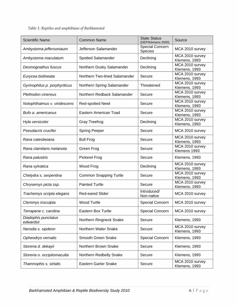
Table 1: Reptiles and amphibians of Barkhamsted
Scientific Name Common Name State Status (DEP/Klemens 2000) Source
Ambystoma jeffersoniaum Jefferson Salamander Special Concern Species MCA 2010 survey
Ambystoma maculatum Spotted Salamander Declining MCA 2010 survey Klemens, 1993
Desmognathus fuscus Northern Dusky Salamander Declining MCA 2010 survey Klemens, 1993
Eurycea bislineata Northern Two-lined Salamander Secure MCA 2010 survey Klemens, 1993
Gyrinophilus p. porphyriticus Northern Spring Salamander Threatened MCA 2010 survey Klemens, 1993
Plethodon cinereus Northern Redback Salamander Secure MCA 2010 survey Klemens, 1993
Notophthalmus v. viridescens Red-spotted Newt Secure MCA 2010 survey Klemens, 1993
Bufo a. americanus Eastern American Toad Secure MCA 2010 survey Klemens, 1993
Hyla versicolor Gray Treefrog Declining MCA 2010 survey Klemens, 1993
Pseudacris crucifer Spring Peeper Secure MCA 2010 survey
Rana catesbeiana Bull Frog Secure MCA 2010 survey Klemens, 1993
Rana clamitans melanota Green Frog Secure MCA 2010 survey Klemens 1993
Rana palustris Pickerel Frog Secure Klemens, 1993
Rana sylvatica Wood Frog Declining MCA 2010 survey Klemens, 1993
Chelydra s. serpentina Common Snapping Turtle Secure MCA 2010 survey Klemens, 1993
Chrysemys picta ssp. Painted Turtle Secure MCA 2010 survey Klemens, 1993
Trachemys scripta elegans Red-eared Slider Introduced/ Non-native MCA 2010 survey
Clemmys insculpta Wood Turtle Special Concern MCA 2010 survey
Terrapene c. carolina Eastern Box Turtle Special Concern MCA 2010 survey
Diadophis punctatus edwardsii Northern Ringneck Snake Secure Klemens, 1993
Nerodia s. sipdeon Northern Water Snake Secure MCA 2010 survey Klemens, 1993
Opheodrys vernalis Smooth Green Snake Special Concern Klemens, 1993
Storeria d. dekayii Northern Brown Snake Secure Klemens, 1993
Storeria o. occipitomaculta Northern Redbelly Snake Secure Klemens, 1993
Thamnophis s. sirtalis Eastern Garter Snake Secure MCA 2010 survey Klemens, 1993
Barkhamsted Amphibian & Reptile Biodiversity Study 2010 6 | P a g e
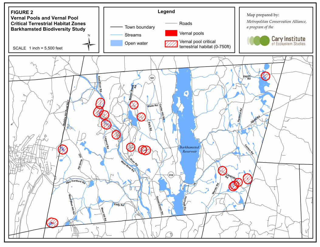
3.2 Vernal Pools A total of eighteen vernal pools were identified in the study area (see Table 2, Figure 2). Vernal pools are seasonal bodies of water that attain maximum depths in the spring and fall. These pools generally lack a surface water connection with other wetlands or waterbodies. The pools are relatively evenly distributed throughout the study area. These vernal pools provide breeding habitat for three vernal pool obligate amphibians, the Wood Frog (Rana sylvatica), Spotted Salamander (Ambystoma maculatum) and Jefferson Salamander. Vernal pools were found at a lower density in Barkhamsted than in other regional vernal pool studies conducted by MCA. The primary factor limiting the occurrence of vernal pools in Barkhamsted is the steeply‐sloping topography which prevents the development of long‐hydroperiod wetlands (see Section 3.1). Additionally, many vernal pools are embedded deep within densely vegetated swamps making detection more difficult. Vernal pools require extensive areas of intact upland forest surrounding them. This terrestrial habitat supports the amphibians that breed within the pool during the non‐breeding portion of their life cycle. Generally, amphibians use vernal pools for breeding for only several weeks in the spring of each year. Calhoun and Klemens (2002) define three important conservation zones of the vernal pool ecosystem: (1) the vernal pool basin; (2) the first 100 feet of upland surrounding the vernal pool basin, referred to as the “vernal pool envelope”; and (3) the next 650 feet surrounding the vernal pool envelope, referred to as the “critical terrestrial habitat zone”. Figure 2 illustrates the vernal pools surveyed in 2010 as well as their terrestrial conservation zones. In order to protect vernal pool ecology, development activities proposed in the vicinity of vernal pools should follow the standards outlined in Calhoun and Klemens (2002) to minimize activities within the vernal pool conservation zones. These “best development practices” (BDP’s) include the use of LID techniques.
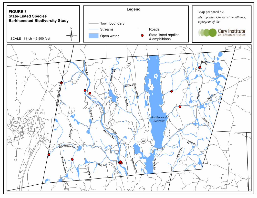
3.3 State‐listed Species State‐listed amphibian and reptile species observed during the survey include the special concern Wood Turtle (Clemmys insculpta), Eastern Box Turtle (Terrapene carolina) and Jefferson Salamander “complex” (Ambystoma jeffersonianum) and the threatened Northern Spring Salamander (Gyrinophilus porphyriticus) (see Figure 3). In addition, the Smooth Green Snake (Opheodrys vernalis) (special concern) has historically been observed in Barkhamsted (Klemens, 1993). Wood Turtles inhabit riparian habitats bordered by floodplain, woodland or meadows. In southern New England, wood turtles occur in swift, clear, pebble‐bottomed streams, as well as meandering, turbid, muddy waters, beaver meadows, fens and wooded swamps. Terrestrial habitats used during the summer include pastures, old fields, woodlands, powerline cuts and railroad beds, bordering on or adjacent to streams and rivers (Klemens, 1993). A total of five wood turtle observations were observed during the study period. This included two individuals observed by Michael Beauchene during stream sampling work conducted in September. All five observations were within or along the banks of the Farmington River near its confluence with Morgan Brook. One additional record, an individual observed in 2000 by
Barkhamsted Amphibian & Reptile Biodiversity Study 2010 7 | P a g e

Deborah Simon on Riverton Road near the Winchester town line was also included in the overall dataset. Eastern Box Turtles inhabit old field habitat and deciduous forest ecotones, including powerline cuts and logged woodlands. Although strictly terrestrial, this species is seldom fond far from water. Box turtle are widely distributed from sea level up to an elevation of 500 feet, becoming scarce and localized to an elevation maximum of just above 700 feet (Klemens, 1993:191). One box turtle was observed in a field bordering the Farmington River. This observation represents a significant range extension for this species in Connecticut. Additional field work will be needed to determine if this was a released turtle (i.e., previously kept as a pet) or whether it represents an indigenous population.
Barkhamsted Amphibian & Reptile Biodiversity Study 2010 8 | P a g e
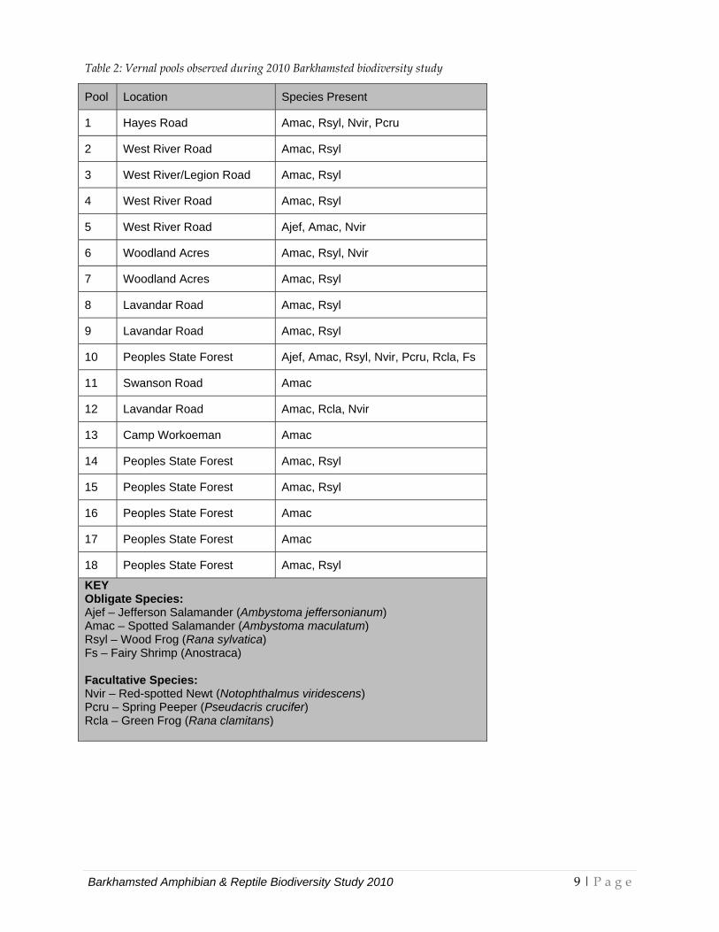
Table 2: Vernal pools observed during 2010 Barkhamsted biodiversity study
Pool Location Species Present
1 Hayes Road Amac, Rsyl, Nvir, Pcru
2 West River Road Amac, Rsyl
3 West River/Legion Road Amac, Rsyl
4 West River Road Amac, Rsyl
5 West River Road Ajef, Amac, Nvir
6 Woodland Acres Amac, Rsyl, Nvir
7 Woodland Acres Amac, Rsyl
8 Lavandar Road Amac, Rsyl
9 Lavandar Road Amac, Rsyl
10 Peoples State Forest Ajef, Amac, Rsyl, Nvir, Pcru, Rcla, Fs
11 Swanson Road Amac
12 Lavandar Road Amac, Rcla, Nvir
13 Camp Workoeman Amac
14 Peoples State Forest Amac, Rsyl
15 Peoples State Forest Amac, Rsyl
16 Peoples State Forest Amac
17 Peoples State Forest Amac
18 Peoples State Forest Amac, Rsyl
KEY Obligate Species: Ajef – Jefferson Salamander (Ambystoma jeffersonianum) Amac – Spotted Salamander (Ambystoma maculatum) Rsyl – Wood Frog (Rana sylvatica) Fs – Fairy Shrimp (Anostraca) Facultative Species: Nvir – Red-spotted Newt (Notophthalmus viridescens) Pcru – Spring Peeper (Pseudacris crucifer) Rcla – Green Frog (Rana clamitans)
Barkhamsted Amphibian & Reptile Biodiversity Study 2010 9 | P a g e
Jefferson Salamanders breed in discrete vernal pools frequently located in bedrock‐controlled topography. These pools often occur in forests that include Hemlock (Tsuga canadensis). They also breed in grassy pasture ponds, small impoundments and shrub swamps. Upland non‐breeding habitats include deciduous or mixed deciduous‐coniferous forest. The Jefferson salamander has not previously been reported from Barkhamsted. This species was confirmed breeding in two vernal pools near the Farmington River, one adjacent to West River Road and one adjacent to East River Road. This species is the most sensitive of the mole salamanders to habitat fragmentation and requires large intact forest blocks for its survival. The term ʺcomplexʺ refers to the fact that Connecticut Jefferson Salamanders occur in mixed populations that are composed of 2n bisexual individuals (males and females) that are genetically pure Jefferson Salamanders along with individuals of various genetic combinations, predominantly female triploids (3n) and tetraploids (4n), that have one set of chromosomes from the Blue‐spotted Salamander (Ambystoma laterale). Bogart and Klemens (1997, 2008) provide detailed studies of the genetics and reproductive ecology of these salamanders. Photo 4 is of a polyploid (most likely 3n) Jefferson ʺcomplexʺ Salamander from Barkhamsted found in our 2010 survey. The Northern Spring Salamander is a State‐listed threatened species which is regionally rare but known to occur in Barkhamsted (Klemens, 1993:65). This species inhabits coldwater streams and groundwater seepages in forested areas. Numerous suitable streams and seepages were surveyed within the study area. Spring salamanders were observed at only one site, in Morgan Brook near West‐West Hill Road. This is a significant range extension for this species into the western section of the town of Barkhamsted (Klemens, 1993:65). The Smooth Green Snake (Opheodrys vernalis) inhabits unforested habitats including meadows, pastures, fens, coastal grasslands and mountaintop “balds” but is also found in transitional and lightly‐forested habitats such as grassy old fields with scattered shrubs and trees, as well as oak‐pitch pine woodlands (Klemens, 1993). The Smooth Green Snake was historically observed in the 1970s near Route 179 (Klemens, 1993:245).
Barkhamsted Amphibian & Reptile Biodiversity Study 2010 10 | P a g e
4.0 LITERATURE CITED Bogart, J. P. and M. W. Klemens. 1997. Hybrids and genetic interactions of mole salamanders (Ambystoma jeffersonianum and A. laterale) (Amphibia: Caudata) in New York and New England. American Museum of Natural History Novitates 3218: 78 pp., 8 figs., 16 tables. Bogart, J. P. and M. W. Klemens. 2008. Additional distributional records of Ambystoma laterale, A. jeffersonianum (Amphibia: Caudata) and their unisexual kleptogens in northeastern North America. American Museum of Natural History Novitates 3627: 58 pp., 8 figs., 7 tables. Calhoun, A. J. K. and M. W. Klemens. 2002. Best Development Practices (BDPs) for Conserving Pool‐breeding Amphibians in Residential and Commercial Developments. MCA Technical Paper No. 5, Metropolitan Conservation Alliance, Wildlife Conservation Society, Bronx, New York. Klemens, M.W. 1993. Amphibians and Reptiles of Connecticut and Adjacent Regions. State Geological and Natural History Survey of Connecticut, Bulletin 112. Klemens, M.W. 2000. Amphibians and Reptiles in Connecticut: A Checklist with Notes on Conservation, Status, Identification, and Distribution. Connecticut Department of Environmental Protection, Bulletin 32. Mitsch, W.J. and J.G. Gosselink. 2007. Wetlands. 4th edition. John Wiley & Sons, Inc. Hoboken, New Jersey.
Barkhamsted Amphibian & Reptile Biodiversity Study 2010 11 | P a g e

APPENDICES
• Photographs 1‐11 • Figures
o Figure 1: Parcels surveyed in 2010 o Figure 2: Vernal pools and vernal pool critical terrestrial habitat zones o Figure 3: State‐listed species
Barkhamsted Amphibian & Reptile Biodiversity Study 2010 12 | P a g e
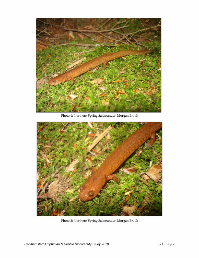
Photo 1: Northern Spring Salamander, Morgan Brook
Photo 2: Northern Spring Salamander, Morgan Brook
Barkhamsted Amphibian & Reptile Biodiversity Study 2010 13 | P a g e
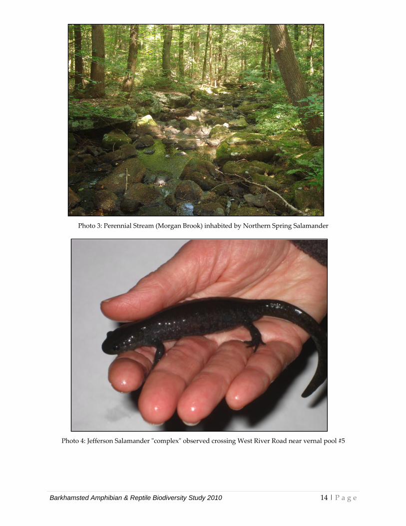
Photo 3: Perennial Stream (Morgan Brook) inhabited by Northern Spring Salamander
Photo 4: Jefferson Salamander ʺcomplexʺ observed crossing West River Road near vernal pool #5
Barkhamsted Amphibian & Reptile Biodiversity Study 2010 14 | P a g e
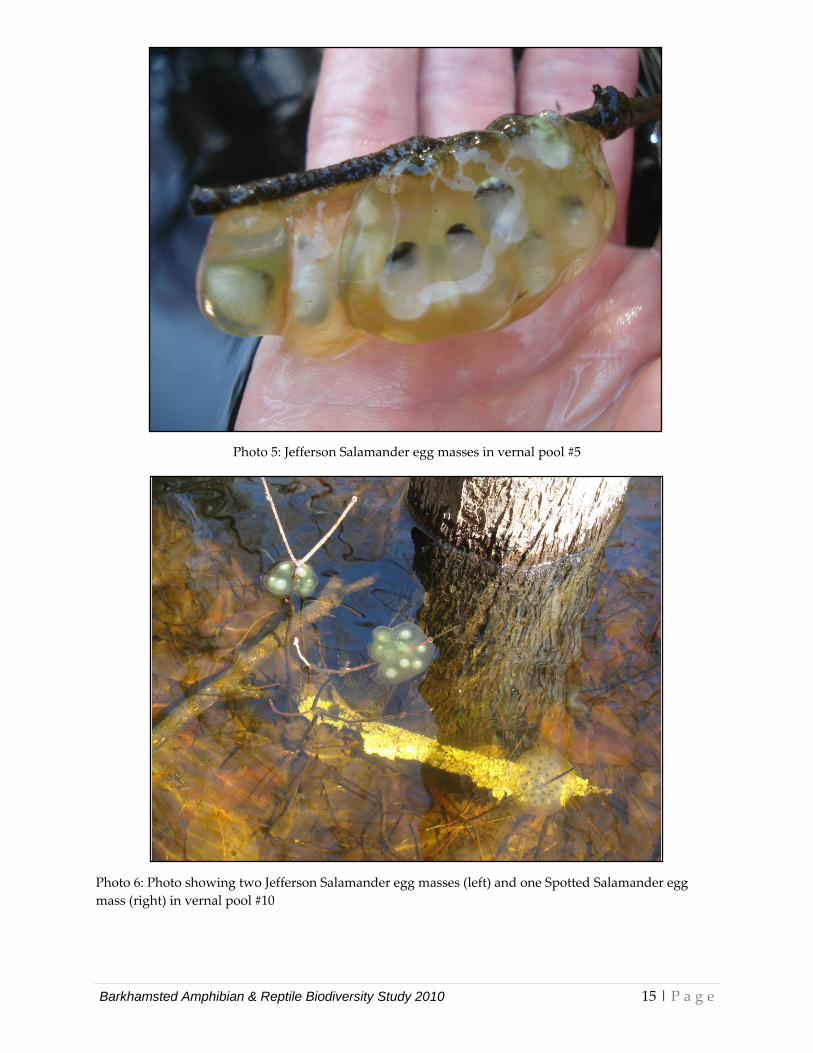
Photo 5: Jefferson Salamander egg masses in vernal pool #5
Photo 6: Photo showing two Jefferson Salamander egg masses (left) and one Spotted Salamander egg mass (right) in vernal pool #10
Barkhamsted Amphibian & Reptile Biodiversity Study 2010 15 | P a g e
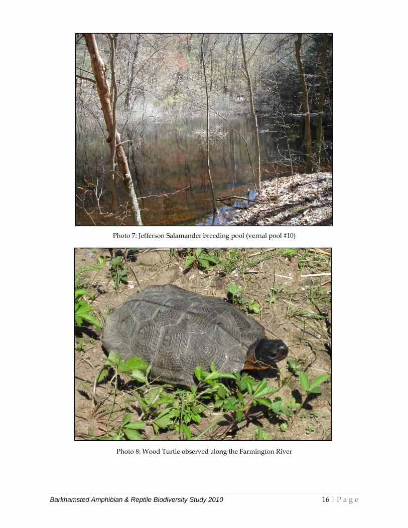
Photo 7: Jefferson Salamander breeding pool (vernal pool #10)
Photo 8: Wood Turtle observed along the Farmington River
Barkhamsted Amphibian & Reptile Biodiversity Study 2010 16 | P a g e
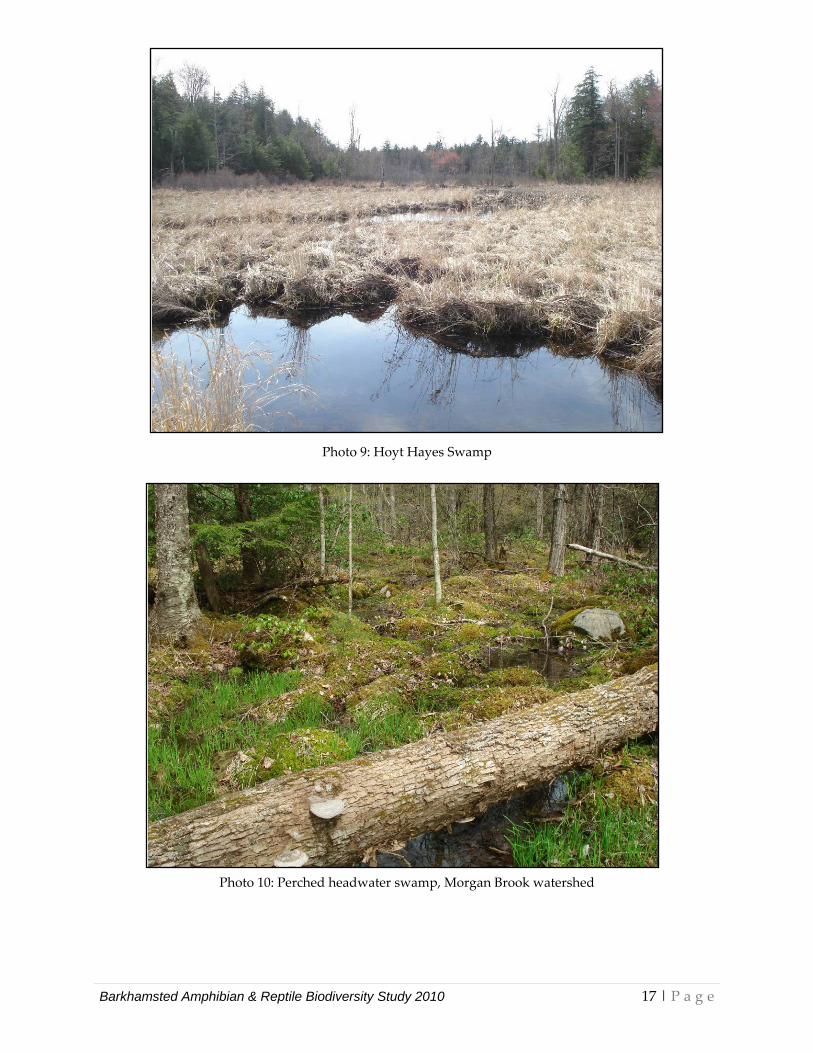
Photo 9: Hoyt Hayes Swamp
Photo 10: Perched headwater swamp, Morgan Brook watershed
Barkhamsted Amphibian & Reptile Biodiversity Study 2010 17 | P a g e
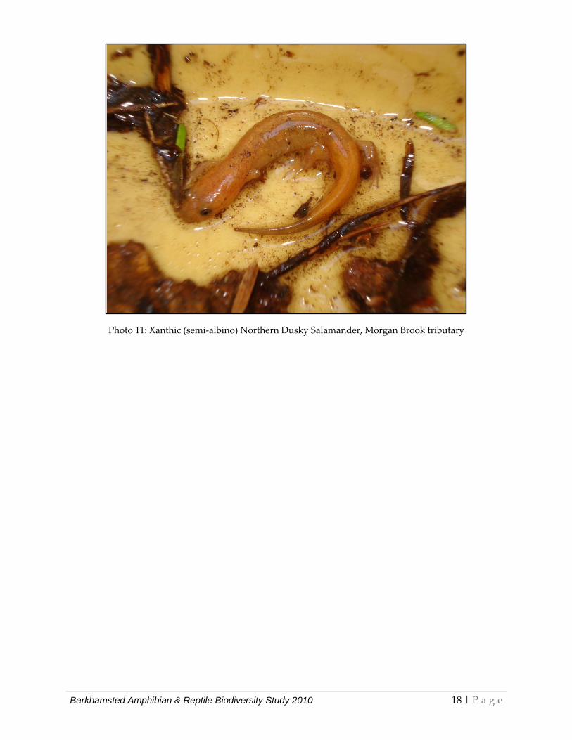
Photo 11: Xanthic (semi‐albino) Northern Dusky Salamander, Morgan Brook tributary
Barkhamsted Amphibian & Reptile Biodiversity Study 2010 18 | P a g e
Mallory Brook
Still River
Kettle Brook
Roaring Brook
Morga
n Broo
kCherry Brook
Storehou
se Broo
k
FIGURE 1Parcels surveyed in 2010 Barkhamsted Biodiversity Study
Map prepared by:
1 inch = 5,500 feet ÜSCALE
Metropolitan Conservation Alliance, a program of the
Legend
WINC
HEST
ERHARTLAND
GRAN
BY
NEW HARTFORD CANTONRatlu
m Brook
BeaverBrook
MorganBrook
Spruc
e Broo
k
Town boundarySurveyed parcelsStreamsOpen water
River
Farmington
Barkhamsted Reservoir
COLEBROOK
New Hartford Rd
OldNorth Rd
¬«318
Hartlan d R d
¬«181
River Rd
Park Rd
Hartl
and R
d
West River Rd
East River Rd
Eddy Rd
Gavitt Rd
West West Hill Rd
Canton Rd
HayesRd
Legend RdWa
rner R
d
Goose Green Rd
Slade Rd
Beav
er Br
ook
Rd
Lavander Rd
Walle
ns H
ill Ro
ad N
o 1 Center Hill Rd
West Hill Rd
FIGURE 2Vernal Pools and Vernal Pool Critical Terrestrial Habitat ZonesBarkhamsted Biodiversity Study
1 inch = 5,500 feet ÜSCALE
Legend
Town boundaryStreamsOpen water
RoadsVernal poolsVernal pool criticalterrestrial habitat (0-750ft)
Map prepared by:Metropolitan Conservation Alliance, a program of the
Barkhamsted Reservoir
New Hartford Rd
OldNorth Rd
¬«318
Hartlan d Rd
¬«181
River RdPark Rd
Hartl
and R
d
West River Rd
East River Rd
Eddy Rd
Gavitt Rd
West West Hill Rd
Canton Rd
HayesRd
Legend Rd
Warne
r Rd
Goose Green Rd
Slade Rd
Beav
er Br
ook
Rd
Lavander Rd
Walle
ns H
ill Ro
ad N
o 1
Center Hill Rd
West Hill Rd
FIGURE 3State-Listed SpeciesBarkhamsted Biodiversity Study
1 inch = 5,500 feet ÜSCALE
Legend
Town boundaryStreamsOpen water
Roads
Map prepared by:Metropolitan Conservation Alliance, a program of the
Barkhamsted Reservoir
State-listed reptiles& amphibians


