Posted: __________ Remove: Town of New Castle 450 W. Main Street PO Box 90 New Castle, CO 81647 Administration Department Phone: (970) 984-2311 Fax: (970) 984-2716 www.newcastlecolorado.org Agenda New Castle Town Council Regular Meeting Tuesday, April 21, 2020, 7:00 PM Starting times on the agenda are approximate and intended as a guide for Council. The starting times are subject to change by Council, as is the order of items on the agenda. Due to concerns related to COVID-19, this meeting will be held as a virtual meeting only. The public is invited to attend by telephone. Please call: 1-346-248-7799 Meeting ID: 709 658 8400 Follow the prompts as directed. Be sure to set your phone to mute until called on. Call to Order Pledge of Allegiance Roll Call Meeting Notice Conflicts of Interest Agenda Changes Citizen Comments on Items not on the Agenda -Comments are limited to three minutes- Consultant Reports Consultant Attorney Consultant Engineer Oaths of Office - Councilor Grady Hazelton, Councilor Graham Riddile and Councilor Crystal Mariscal. Items for Consideration A. Consider a Letter of Interest from Tom Elder for Appointment to Seat on the Climate Action Advisory Committee (7:05 p.m.) B. Consider a Letter of Interest from Beth Sass for Reappointment to a Seat on the Planning & Zoning Commission (7:10 p.m.)
Transcript
Posted: __________
Remove:
Town of New Castle 450 W. Main Street
PO Box 90
New Castle, CO 81647
Administration Department Phone: (970) 984-2311
Fax: (970) 984-2716
www.newcastlecolorado.org
Agenda
New Castle Town Council Regular Meeting
Tuesday, April 21, 2020, 7:00 PM
Starting times on the agenda are approximate and intended as a guide for Council.
The starting times are subject to change by Council, as is the order of items on the agenda.
Due to concerns related to COVID-19, this meeting will be held as a virtual
meeting only. The public is invited to attend by telephone.
Please call: 1-346-248-7799
Meeting ID: 709 658 8400
Follow the prompts as directed. Be sure to set your phone to mute until called on.
Call to Order
Pledge of Allegiance
Roll Call Meeting Notice
Conflicts of Interest Agenda Changes
Citizen Comments on Items not on the Agenda -Comments are limited to three minutes-
Consultant Reports Consultant Attorney
Consultant Engineer
Oaths of Office - Councilor Grady Hazelton, Councilor Graham Riddile and
Councilor Crystal Mariscal.
Items for Consideration
A. Consider a Letter of Interest from Tom Elder for Appointment to Seat on
the Climate Action Advisory Committee (7:05 p.m.)
B. Consider a Letter of Interest from Beth Sass for Reappointment to a Seat
Historic Preservation Commission Climate Action Advisory Committee Senior Program
RFTA AGNC
GCE EAB
Council Comments (9:10 p.m.)
Adjourn (9:30 p.m.)
Hello Melody, I wish to express my interest in joining the Climate Action Advisory Commission as it final member. I can commit to the meeting schedule and also be available for extracurricular activities, as well. Please toss one of my hats into the drawing. Thank You, Tom Elder
To City Council:
I would like to continue as a member of the Planning and Zoning commission
for New Castle. I have enjoyed my time and I am learning a lot about our community. I think it is important to be involved at a local level and would
like to continue to do so on the Planning and Zoning team. Thank you for the opportunity to serve my community.
Beth Sass
970-948-4741
ATTN: Melody Harrison/Mindy Andis 450 W. Main Street PO Box 90 New Castle, CO 81647 [email protected]/[email protected] RE: Town of New Castle Planning and Zoning Commission- Letter of Interest To Melody Harrison and Mindy Andis; I would like to express my interest to continue to serve on the Planning and Zoning Commission for the Town of New Castle. I have enjoyed learning ‘a different side of planning’ these past few years and few that I have grown from the experience. I will continue to serve as an advocate for the community with the perspective of a citizen who is not only a Colorado licensed Landscape Architect and an AICP certified planner, but also a mother and a family within the community- which is an incredibly important voice to have- because not all parents can find the time to participate in the public process. I will continue to strive to represent the vision of New Castle; “Western Colorado’s best kept secret, mountain living, small town charm and killer outdoor recreation opportunities”. The scenic beauty, the character, access to parks and trails and the kindness of our neighbors is why we love to call this town our home. I also understand change is a part of this growing community. It is an exciting time to be on planning commission- we play an essential to thinking through issues around growth in New Castle. I have learned a lot over the past few years about the history of development and how important it is that we are thoughtful and deliberate in future planning decisions so that change aligns with our community values that growth continues to contribute to making New Castle a great place to live and play. Sincerely,
Alison Cotey Bourquin, PLA, AICP, CDT, LEED@GA
Attn: Paul Smith & Dave Reynolds d.b.a.
Town of New Castle
450 W Main Street
New Castle, CO, 81647
To Whom It May Concern,
Please consider this my declaration of interest in further involvement in the Town of New Castle
Planning and Zoning Commission. As a local homeowner, Contractor, and Realtor™, I am keenly aware
of many of the concerns relevant in the decisions made by this council, and the importance of
thoughtful discussion and conclusions. It is after my attendance at many PnZ meetings that I find myself
with a desire to learn and enrich the community by joining the commission.
I am passionate about our beautiful town, and have many ideas on how we can work with and
for the people to help manage and preserve the land and its development around us. I am interested in
guiding natural growth while maintaining the nature of the town. I believe New Castle has a long and
resounding history, and I want to preserve that history while improving the lives of the people of this
Town and our visitors.
If there are any questions or if I can be of further assistance, please feel free to contact me
Via U.S. Mail and Email: [email protected] Melody Harrison, Town Clerk Town of New Castle P.O. Box 90 New Castle, CO 81647 RE: Town of New Castle Municipal Judgeship Dear Melody: I am interested in continuing my appointment by Town Council for an additional 2-year term as Municipal Judge for the Town of New Castle. A copy of my current resume is enclosed. I have been serving as Municipal Judge in New Castle since April 2012 and previously served as Assistant Municipal Judge from April 2006 through April 2012. I am currently serving as Municipal Judge in Glenwood Springs and also serve as assistant municipal judge in Rifle and Silt. Except for my initial term as municipal judge from 2012-2014 when I had an hourly rate of compensation that carried forward from serving as assistant judge prior to 2012, I have been serving at a per diem rate of $800.00. We have court one day per month and I cover other tasks via email and telephone, including reviewing and responding to motions and holding telephone advisements for in custody defendants, throughout the month as needed. Thus, the per diem rate is effectively a flat rate per month. On occasion I have court hearings outside of the regularly scheduled docket day and I use my discretion whether to invoice for the additional court time. If I do invoice for it, I do not invoice for an additional full day if the hearing was a half day, etc. The per diem (monthly) rate of compensation has been $800.00 since at least 2010. I did not research the per diem rate prior to 2010. I have attached an inflation calculator that reflects, with inflation, $949.03 in 2020 would be equivalent to $800.00 in 2010. I request an increase to the per diem compensation from $800.00 to $1,000.00 commencing in May 2020 for the 2-year appointment term from May 2020 to April 2022. I am not requesting any other changes to the compensation or expense reimbursement, but am open to discussing this further with Council members at Council’s request. I am subject to self-employment taxes as an
OLSZEWSKI, MASSIH & MAURER, P.C.
Town of New Castle March 20, 2020 Page 2 of 2
independent contractor and do not receive employment benefits through this position. We rarely hold court on more than one day per month. The per diem compensation would also cover the time I am available and on call to review and execute warrants and give advisements in person or via telephone to defendants that are in jail and unable to post bond so that they do not remain in jail without an advisement beyond the state mandated timeframe of 48 hours, excluding Sundays and holidays. I also spend time out of court reading materials to keep apprised of municipal court issues in the State of Colorado and discussing Town of New Castle municipal issues and potential statute revisions and administrative orders with town attorneys, the police chief and court staff. I attend the Colorado Municipal Judges’ Association conferences and incorporate the information gained through the conferences into our court practices when beneficial. In sum, I request to receive per diem (effectively per month) compensation of $1,000 per diem and continue to have the ability to request reimbursement for Colorado Municipal Judges’ Association conference registration fees and some travel expenses of up to $1000 per year. Please contact me with any questions. If the April 21, 2020 Town Council meeting is still scheduled, I will attend. If the meeting is cancelled, please let me know if the Town Council will take action without a meeting to continue my appointment. My current appointment expires April 30, 2020. Very truly yours,
OLSZEWSKI, MASSIH & MAURER, P.C.
By: _________________________________
Amanda N. Maurer Enclosures
AMANDA N. MAURER P.O. Box 916 1716 Bennett Avenue 1204 Grand Avenue Glenwood Springs, CO 81601 Glenwood Springs, CO 81602 C: 970.618.8919 P: 970.928.9100 F: 970.928.9600 [email protected]
EXPERIENCE OLSZEWSKI, MASSIH & MAURER, P.C., Glenwood Springs, Colorado (formerly AMANDA N. MAURER, P.C.) Shareholder, January 2004 – Present MUNICIPAL JUDGE APPOINTMENTS Town of New Castle, Colorado: Municipal Judge, April 2012 - Present/Associate Judge 2006 - 2012 City of Glenwood Springs, Colorado: Municipal Judge, 2017 - Present/Substitute Judge, 2007 – 2016 City of Rifle, Colorado: Associate Municipal Judge, October 2008 - Present Town of Gypsum, Colorado: Associate Municipal Judge, July 2014- Present Town of Silt, Colorado: Associate Municipal Judge, July 2014- Present BALCOMB & GREEN, P.C., Glenwood Springs, Colorado Associate Attorney, September 2001 – June 2004 GROSSBERG, YOCHELSON, FOX & BEYDA, LLP, Washington, D.C. Law Clerk, May 1999 – May 2001
EDUCATION THE GEORGE WASHINGTON UNIVERSITY LAW SCHOOL, Washington, D.C. Juris Doctor, With Honors, May 2001
• The George Washington International Law Review, Notes Editor • Alternative Dispute Resolution Board, Member and Regional Competitor for Client Counseling
GEORGETOWN UNIVERSITY, Washington, D.C. Bachelor of Science in Business Administration, May 1998; Dean’s List, 1996-1998
• Major: Management, with a concentration in New and Small Business; Minors: Government and Philosophy • Gannett Award for Academic Excellence in Negotiation, Arbitration and Labor Relations
PROFESSIONAL CREDENTIALS
• Admitted to Practice in the Courts of the State of Colorado by the Colorado Supreme Court on
October 15, 2001. (Attorney Registration Number 33361)
• Admitted to Practice in front of the United States District Court, District of Colorado on September 22, 2003.
PROFESSIONAL ASSOCIATIONS AND MEMBERSHIPS
• Colorado Municipal Judges Association, Member • Colorado Bar Association, Member • Ninth Judicial District Bar Association, Member • American Bar Association, Member
Memorandum To: Mayor & Council From: David Reynolds Re: Agenda Item – Mountain Waste Annual Update Date: 4-21-20 Purpose:
The purpose of this agenda item is to allow our service provider Mountain Waste time to present the “Town of
New Castle Year End Diversion Report 2019.” Mountain Waste & Recycling keeps running statistics on the
amounts of recycled materials collected in the Town of New Castle. Also tracked are the fees that are charged
for dumping of the recycled materials. While in general the cost to dispose of recycled materials has begun to
level off, the costs do remain higher than reported 6 months ago.
Mountain Waste will provide a full accounting of costs related to recycling and waste management and will
answer any questions that Council members may have.
Administration Department Phone: (970) 984-2311
Fax: (970) 984-2716
www.newcastlecolorado.org
Town of New Castle 450 W. Main Street
PO Box 90
New Castle, CO 81647
TOWN OF NEW CASTLE YEAR END DIVERSION REPORT 2019
Mountain Waste & Recycling is proud to present our annual recycling and diversion report for 2019. Our recycling
program is our commitment to the conservation of planet Earth’s natural resources and by providing this report, we
hope to inspire the community at large to become involved in our efforts.
Community Diversion Rate A diversion rate compares the amount of material collected that was recycled or diverted from the landfill, compared to the total waste generated by the town. This information is useful for tracking trends in the community.
Mountain Waste & Recycling manages the solid waste generated by the residences of New Castle, Co. This includes the safe and proper disposal of municipal solid waste and recyclables. The recyclables collected from the Town of New Castle, Co. are taken to the Alpine Waste All Together MRF in Denver, Co. Mountain waste serviced an average of 1458 households weekly within the town limits of New Castle, Co. in 2019.
Managed Recyclables
Office paper and discarded mail • Newspaper and magazines
Corrugated cardboard, brown paper bags, paperboard and pizza boxes
gable-top cartons, aseptic cartons
Glass food and beverage containers • Metal food and beverage containers
2019 Annual Waste Diversion Report to The Town of New Castle CO
Number of Residential
Customers Trash Tonnage Single Stream Recycling Total Landfill Diversion / TONS
2019 Landfill Diversion
Rate
2018 Landfill Diversion
Rate
January 1442 125.86 23.7 23.7 15.85% 15.95%
February 1446 113.47 19.6 19.6 14.73% 14.43%
March 1446 112.82 23.1 23.1 17.00% 16.45%
April 1449 139.01 25.4 25.4 15.45% 14.75%
May 1460 185.55 33.9 33.9 15.45% 13.49%
June 1470 123.12 30.1 30.1 19.64% 18.13%
July 1467 189.95 34.4 34.4 15.33% 17.50%
August 1468 153.72 28.9 28.9 15.83% 14.94%
September 1466 143.52 28.1 28.1 16.37% 14.91%
October 1456 178.87 34.6 34.6 16.21% 16.92%
November 1461 141.34 26.5 26.5 15.79% 15.02%
December 1462 132.87 24.7 24.7 15.68% 15.67%
Summary 1458 1740.1 333 333 16.06% 15.58%
Avg Homes per Month Total Tons Tons Tons Diverted
3,480,200 #'s 666,000 #'s
Note: 5 Service Weeks
RecyclingRecycling Tipping /
Processing
Cost Per Ton
March 2018 $18.55
January 2019 $20.06February 2019 $23.54
March 2019 $26.29 41.72% Increase in 12 Months
June 2019 $28.28
July 2019 $36.01
August 2019 $39.10
September 2019 $70.71 281.19% Increase in 18 Months
October 2019 $83.09
November 2019 $84.64December 2019 $82.81
February 2020 $82.91 346.95% Increase in 24 Months
215.37% Increase in 12 Months
17.25% Increase in 6 Months
.001% Increase in 3 Months
Memorandum To: Mayor & Council From: David Reynolds Re: Agenda Item – Resolution 2020-15 Date: 4-21-20 Purpose:
The purpose of this agenda item is to review and consider Resolution 2020-15.
The Recreation Center within Lakota Canyon Ranch was constructed with a commercial kitchen, dining area,
service window and snack bar area. Throughout its history, the kitchen and dining area have been operated as
a snack bar for pool guests, a small restaurant for golfers, a small restaurant which was open to the public, and
a gathering and meeting space for Lakota residents, guests, and other patrons.
In 2018 the Recreation Center was sold by the developer Warrior Golf to the Lakota Home Owners Association
(HOA). The HOA made arrangements for a third-party operator to run the snack bar / restaurant on behalf of
the HOA. The business was known as Capital Deli and operated for several months serving both Lakota
residents and the general public.
Recently the HOA has decided to run the snack bar / restaurant using the talent and experience of Lakota
residents along with additional support staff. As always, the facility’s first mission will be to serve the needs of
the immediate community, but as in the past, it will also serve dinning guests, meeting guests, golfers and
visitors from outside of Lakota.
In 2005 the Town approved resolution 2005-4 which included a list of approved conditions for the use of this
property. The resolution spoke specifically about the operation of a real estate office and marketing space as a
commercial element of the property, but it did not specifically address the approved uses of the kitchen and
dining areas. Because this building appears to have a historical use which is consistent with the original site
plan and the current zoning, and because the current proposed use remains essentially the same
as the original intent; staff recommends amending Resolution TC 2005-4 in order to clarify and memorialize
the ability to operate this kitchen and dining space for food and beverage service as described in
Resolution 2020-15.
Below for your reference please see Resolution 2005-4 Section 3A
Administration Department Phone: (970) 984-2311
Fax: (970) 984-2716
www.newcastlecolorado.org
Town of New Castle 450 W. Main Street
PO Box 90
New Castle, CO 81647
TOWN OF NEW CASTLE, COLORADO
RESOLUTION NO. TC 2020-15
A RESOLUTION OF THE NEW CASTLE TOWN COUNCIL AMENDING
RESOLUTION NO. TC 2005-4 REGARDING SITE PLAN APPROVAL FOR THE
LAKOTA CANYON RANCH RECREATION CENTER.
WHEREAS, on April 5, 2005, the Town Council approved a site plan for the Lakota
Canyon Ranch Recreation Center (“Recreation Center”) pursuant to Resolution No. TC
2005-4; and
WHEREAS, the Lakota Canyon Ranch Homeowners Association, Inc.
(“LCRHOA”) now owns and operation the Recreation Center; and
WHEREAS, LCRHOA desires to provide food and beverage service at the
Recreation Center for its members, guests, and members of the public and may contract
with a third-party operator to provide such services; and
WHEREAS, the services described above are consistent with the original site plan
for the Recreation Center approved by Resolution TC 2005-4 and are consistent with the
existing zoning designation for the Recreation Center as private parkland with the Open
Space District of Lakota Canyon Ranch PUD; and
WHEREAS, Resolution TC 2005-4 included certain restrictions on uses of the
Recreation Center that no longer apply since the transfer of ownership of the Recreation
Center to LCRHOA as condition 3(A), and the Town Council desires to amend Resolution
TC 2005-4 as set forth below.
NOW, THEREFORE, BE IT RESOLVED BY THE NEW CASTLE TOWN
COUNCIL AS FOLLOWS:
1. Recitals. The foregoing recitals are incorporated by reference as findings
and determinations of the Town Council.
2. Amendment. Section 3(A) of Resolution TC 2005-4 is hereby amended and
replaced to read as follows:
A. Lakota Canyon Ranch Homeowners Association, Inc. may use the
Recreation Center for association-related activities, which may include, but are not limited
to, the sale and provision of food and beverages to users of the Recreation Center, including
members of the association, their guests, and members of the general public. The
Association may provide such services itself or by contracting with a third-party operator.
The Association shall be responsible to maintain any restaurant, kitchen or liquor licenses
that may be required in connection with these services.
Resolution 2020-21
Page 2 of 2
298941-1
INTRODUCED, PASSED, AND ADOPTED by a vote of __ to __ at a regular
meeting of the New Castle Town Council held on April 21, 2020.
TOWN COUNCIL OF TOWN OF
NEW CASTLE, COLORADO
Art Riddile, Mayor
ATTEST:
Melody Harrison, Town Clerk
Planning Commission – Public Hearing Exhibits
Text Amendments – Gravel and Mining
April 22, 2020
Exhibit # Exhibit Description
1 Staff Memo
2 Article 14 - Proposed 1041 Text Amendments
3 Article 15 – Proposed Definition Amendments
4 Other Land Use Code Text Amendments – Articles 3 and 7
5 Garfield County Land Use and Development Code, as Amended
6 Garfield County Comprehensive Plan of 2030
7 Public Notice – Proof of Publication
8 Public Hearing Notice Information Form
9 Public Comments
1
MEMORANDUM
TO: Garfield County, Planning Commission
FROM: Sheryl Bower, AICP, Community Development Director
Patrick Waller, AICP, Senior Planner
Glenn Hartmann, Principal Planner
DATE: April 22, 2020
SUBJECT: Public Hearing for consideration of Amendments to the Garfield County Land Use
and Development Code of 2013 as amended, including but not limited to Articles
3, 4, 7, 14, and 15 in regard to “Extraction, Gravel” and “Extraction, Mining and
Other”.
Background
On November 18, 2019, the Board of County Commissioners adopted a six-month moratorium
on new or amended applications for gravel and mining extraction in Garfield County (Resolution
2019-58). The Resolution describes the Purpose of the Moratorium as cited below:
2. Purpose. The purpose of this Moratorium is to provide the Commission with proper tools
to protect the public health, safety and welfare of the residents of Garfield County and to
protect natural resources, environmentally sensitive lands, and to conserve and preserve
the character of the County.
Additionally, as part of the Moratorium Resolution, the BOCC directed Staff to review existing
Land Use and Development Code regulations regarding gravel and mining extraction uses.
On January 29th the BOCC held a work session with staff and Barbara Green Esq, a consultant
hired to assist staff with the development of regulations. At the work session, information was
presented on existing codes, along with a discussion on how the County could utilize it’s 1041
powers to adequately review significant mining operations.
2
1041 Powers are derived from State Statute and allow local jurisdictions to regulate Areas and
Activities of State Interest. This can include the regulation of Mineral Resource Areas. The
regulation can be applicable to uses on private property and federal property.
On March 25th and April 1st the Planning Commission and Board of County Commissions held
joint work sessions to discuss the draft proposed changes to Article 14. The adoption of 1041
regulations are not required by statute to go through the process typically utilized for Land
Development Code Regulations (LUDC), i.e. review and recommendation by the Planning
Commission is not required. However, because the implementation of 1041 regulations requires
that parts of the LUDC be amended to remove reference to mining activities and provide updated
definitions to distinguish “gravel extraction” from “mining other”, and because of the value
provided by Planning Commission review, the Planning Commission has been utilized as a
reviewing entity. During the work session, the Planning Commission and Board of County
Commissioners did have discussion on sections of the regulations and staff made some changes
to the document as a result.
RECAP 1041 Regulations
The 1041 Section of the Land Use and Development Code functions as a stand-alone code section,
covering process, criteria, and submittal requirements. The existing 1041 regulations include
specific levels of review, depending on prescribed thresholds. It is possible for an application to
be processed as either a Finding of No Significant Impact, a Minor Permit Review Process, or as a
Major Permit Review Process. Specific Submittal Requirements are identified and waivers from
this section are permitted with a decision by the Director as referenced in Sections 14-301, 14-
302, and 14-303.
Garfield County has already adopted 1041 Regulations for the following Areas and Activities of
State Interest:
Section 14-103 A. Areas of State Interest.
1. Areas around Airports and Heliports. Specifically, the outer extremities of the Imaginary
Surfaces for the Airport or Heliport, including all lands, water, airspace, or portions
thereof which are located within this boundary. If the Noise Impact Boundary extends
beyond the outer extremities of the Imaginary Surfaces, the Imaginary Surfaces shall be
extended to incorporate the Noise Impact Boundary for purposes of this Article.
2. Areas around Rapid or Mass Transit Facilities, Terminals, Stations, or fixed guideways.
Section 14-103 B. Activities of State Interest.
1. Efficient utilization of municipal and industrial water projects.
3
2. Site Selection and development of Solid Waste Disposal Sites except those sites specified
in C.R.S. § 25-11-203(1), sites designated pursuant to Part 3 of Article 11 of Title 25, C.R.S.,
and hazardous waste disposal sites, as defined in C.R.S. § 25-15-200.3.
3. Site Selection and construction of major new domestic water and sewage treatment
systems and major extension of existing domestic water and sewage treatment systems.
4. Site Selection and construction for Arterial Highways, Interchanges, and Collector
Highways.
5. Site Selection and construction for Rapid or Mass Transit Terminals, Stations, or
guideways.
6. Site Selection for public Airport or Heliport location or expansion.
Staff along with Ms. Green, identified a few reasons why utilizing 1041 regulations would be an
effective regulatory tool for considering mining operations (with the exclusion of gravel
operations). This included: providing for a one stop shop for mining regulations, the new
regulations can be effectively added to the existing 1041 framework, and primarily that 1041
gives the County additional tools to address the more intense and complex impacts that can be
associated with large-scale mining projects.
Specifically, the 1041 Regulations identify a comprehensive list of potential submittal
requirements (based on individual project applicability) including a Socioeconomic Impact
Analysis, Description of Technical and Financial Feasibility of the Project, and Environmental
Impacts – that address Air Quality, Visual Quality, Surface Water Quality, Groundwater Quality,
Water Quantity Floodplains, Wetlands, Riparian areas, Aquatic Animals and Habitat, Terrestrial
Plan Life, Soils, Geological Conditions, and Natural Hazards. When an applicant meets with staff
for a pre-application meeting, it will be determined which submittal requirements will pertain to
their specific project. Studies or requirements that are not relevant will be waived.
In addition to the above noted potential submittal requirements, the 1041 review criteria
addresses items that are not included in other Sections of the Land Use and Development Code
including criteria related to the financial burden on the County, Effects on the Economy,
Maintenance of Recreational Experience, Alternatives Analysis, and finding of the associated
Benefits Versus Loss of Resources. The Regulations also allow for additional use-specific
standards to be included.
Once an applicant has met with staff at a pre-application meeting, the Director will determine
what level of review will be required. Review tiers are categorized as a Finding of No Significant
Impact (FONSI), a Minor Permit Review, or a Major Permit Review. If a project is, without
mitigation unlikely to have any significant adverse impact, the Director may make a Finding of No
Significant Impact (FONSI). If a FONSI is issued, there are no further requirements under 1041,
however the project is still subject to review by other agencies (as required) and any required
4
building or grading permits. Minor and Major reviews are differentiated by the degree in which
the project can have significant or severe adverse impacts, with a project being categorized as
“Major” if it is likely to have significant adverse impact in 2 or more categories of standards as
described in Division 5 of the 1041 regulations or a “severe” adverse impact in any one category.
Proposals that do not meet the criteria of a major permit review are reviewed as minor permit
review. The Board of County Commissioners (BOCC), applicant or the Director can call the
determination of level of review to the BOCC.
1041 regulations have submittal requirements and standards that apply to all activities subject
to 1041 regulations. There are also activity specific submittal requirements and standards.
Because the County’s 1041 Regulations were written several years ago, staff had asked the
consultant to suggest revisions to both the requirements/standards applicable to all 1041
activities, along with adding those that are specifically directed at mineral resources. As a result
of this request, a number of changes are proposed to the general standards.
Proposed Changes to Article 14: Areas and Activities of State Interest.
Below is a general description of proposed changes. The specific changes are shown in an edited
Article 14 Document attached to this packet.
• Added “Mineral Resource Areas” to the list of “Areas of State Interest”.
• Proposed new definitions to clearly differentiate between gravel operations (still
subject to Article 3 and 7-1002 of the LUDC) and Mining Operation (subject to
Article 14).
• Under Division 3. Review Process for 1041 Permit.
▪ Maintained the current 3 levels of review and relief.
1. A Finding of No Significance for construction/operations
that without mitigation are unlikely to have any significant
adverse impacts.
2. Major Permit Review, when the project is likely to have a
significant adverse impact in 2 or more categories of
standards (see Division 5, 1041 Permit Approval Standards
or the project is likely to have severe adverse impact in any
1 category of standards.
3. Minor Permit review for any project which falls between a
Finding of no Significant Impact and a Major Impact.
4. Provides for relief from the Directors determination, via a
call up provision to BOCC.
• Under 14-401 Description of Submittal Requirements. This section provides a list of
submittal requirements that would apply to any 1041 minor or major review. It should
5
be noted that as a part of the process, staff would go through this list with the
applicant and determining if everything specified is required. It is not staff’s intent to
ask for information that is not pertinent to the review.
• 14-412. New Section. This section outlines the additional submittal requirements
applicable to mining operations in mineral resource areas. Again, depending on the
scope of the project submittal, requirements can be waived.
• Division 5. 1041 Permit Approval Standards. This section covers the permit approval
standards applicable to any 1041 minor or major review. Most of the changes in this
section resulted from information either being moved here from other sections or
moved to other sections.
• Added 14-508 Additional Standards Applicable to Mining Operations in Mineral
Resource Areas. This section identifies the standards that will be considered during
review of mining operations.
Where would the Mineral Resource Areas be located?
Staff is proposing that mineral resource areas include the Rural, Public Lands (including Talus,
Gentle Slopes, Escarpment, Plateau) and Resource Lands Zone Districts. Lands that would not be
included are all other zoning districts, Planned Unit Developments (PUD), along with lands that
fall into a municipality’s Urban Growth Boundaries (except where urban growth boundaries are
overlaid on public lands). Mining Operations would not be permitted in Industrial Zoned lands
because of the limited amount of land in the county designated as Industrial. Additionally, mining
is not permitted in Planned Unit Developments as these areas are generally residential in nature.
The interactive map is available for review here: https://data-
garfieldcolorado.opendata.arcgis.com/pages/topics
Other Amendments to the Code.
Amending the LUDC so that Mining Operations are subject to 1041 Regulations requires
additional amendments to the other portions of the Code besides Article 14. With the
amendment to make the use subject to 1041 Regulations, the LUDC needs to be updated to
remove Mining from the use table and to remove additional use specific Article 7 Standards – in
Section 7-1003. To make the Code easy to follow these sections have been updated to identify
that Mining Operations are subject to 1041 regulations as detailed in Article 14. These updates
are included in this packet as Exhibit 4.
6
Public & Referral Comments
Staff received numerous comments from the Public on the proposed Text Amendments. All were
in favor of regulating Mineral Operations with 1041 Powers. The comments are available for
review as Exhibit 9.
The proposed Text Amendments were also sent to Garfield County Environmental Health,
Department of Reclamation Mining and Safety, and Colorado Parks and Wildlife for their review.
At this time, comments have been received from the Environmental Health Department and
incorporated into the draft document.
Suggested Findings
Outlined below are suggested findings for inclusion in a Commission motion for approval of Text
Amendments the Land Use and Development Code of 2013 as amended, including but not limited
to Articles 3, 4, 7, 14, and 15 in regard “Extraction, Gravel” and “Extraction, Mining and Other”
uses.
1. That proper public notice was provided as required for the hearing before the Planning Commission. 2. The hearing before the Planning Commission was extensive and complete, that all pertinent facts, matters and issues were submitted and that all interested parties were heard at that meeting. 3. That the Code Text Amendment is in compliance with the criteria for approval established in Section 4-114 of the Land Use and Development Code; and 4. That for the above stated and other reasons the proposed Code Text Amendment is in the best interest of the health, safety, convenience, order, prosperity and welfare of the citizens of Garfield County. Recommendation
The following options are provided for the Commission’s consideration consistent with the above
findings.
Option 1: The Planning Commission provides a recommendation to the Board of County
Commissioners for approval of the Text Amendments consistent with the Staff Recommendation.
Staff recommends approval of Text Amendments to the Land Use and Development Code of 2013
as amended, including but not limited to Articles 3, 4, 7, 14, and 15 in regards to “Extraction,
7
Gravel” and “Extraction, Mining and Other” uses as outlined in the Staff Memo dated April 22,
2020 and associated Exhibits 2, 3, and 4.
Option 2: The Planning Commission provides a recommendation to the Board of County
Commissioners for approval of the Text Amendments with modifications to the Staff
Recommendation as specifically outlined in the Planning Commission Motion.
GARFIELD COUNTY, COLORADO
Article 14: Areas and Activities of State
Interest
04/14/2020 DRAFT REVISIONS: MINING OPERATIONS
LUDC 2013
GARFIELD COUNTY LAND USE AND DEVELOPMENT CODE 14-i
DRAFT 04/14/2020
Article 14 AREAS AND ACTIVITIES OF STATE INTEREST
TABLE OF CONTENTS
TABLE OF CONTENTS TO BE COMPLETED
GARFIELD COUNTY LAND USE AND DEVELOPMENT CODE 14-ii
DRAFT 04/14/2020
(This Page Left Blank Intentionally)
GARFIELD COUNTY LAND USE AND DEVELOPMENT CODE 14-1
DRAFT 04/14/2020
ARTICLE 14: AREAS AND ACTIVITIES OF STATE INTEREST
DIVISION 1. GENERAL.
14-101. PURPOSE AND INTENT. UPON ENACTING HOUSE BILL 1041 IN 1974, THE STATE LEGISLATURE IDENTIFIED SEVERAL GENERAL TYPES OF LAND AREAS AND LAND USE ACTIVITIES THAT COULD POTENTIALLY AFFECT “STATE INTERESTS.” THE LAW AUTHORIZED COUNTIES TO DESIGNATE AND REGULATE CERTAIN AREAS AND ACTIVITIES WITHIN THEIR RESPECTIVE JURISDICTIONS THAT FALL WITHIN THOSE GENERAL CATEGORIES OF STATE INTEREST.
A. GENERAL PURPOSE. The purpose of this Article is to facilitate the identification, designation, and administration of matters of state interest consistent with the statutory requirements and the criteria set forth in C.R.S. § 24-65.1-101, et seq. The purpose of this Article is to establish the framework for identification, designation and administration of matters of state interest in a manner that conserves natural resources, is sensitive to surrounding land uses, and protects the public health, safety, welfare and the environment of Garfield County consistent with .C.R.S. § 24-65.1-101, et seq.
B. GUIDELINES AND REGULATIONS FOR ADMINISTRATION. This Article shall constitute the guidelines and regulations for administration of matters of state interest under C.R.S. § 24-65.1-402.
C. INTENT. It is the intent of the County that this Article be applied in a manner that is complementary to and harmonious with the state and federal regulatory laws and regulations.
14-102. AUTHORITY AND SEVERABILITY.
A. Authority. This Article is authorized by, inter alia, C.R.S. §§ 24-65.1-101, et seq; §§ 29-20-101, et seq; §§ 30-28-101 et seq; and §§ 30-28-201, et seq.
B. Severability. If any section, subsection, sentence, clause, or phrase of this Article is, for any reason, held to be invalid or unconstitutional by a court of law, such decision will not affect the validity of this Article as a whole or any part other than the part declared invalid.
14-103. APPLICABILITY.
This Article will apply to the Designation and regulation of any area or activity of state interest wholly or partially in the unincorporated areas of Garfield County, whether on public or private land, that has been or may hereafter be designated by the BOCC.
14-104. DESIGNATED MATTERS OF STATE INTEREST.
A. Areas of State Interest.
1. Areas around Airports and Heliports. Specifically, the outer extremities of the Imaginary Surfaces for the particular Airport or Heliport, including all lands, water, airspace, or portions thereof which are located within this boundary. If the Noise Impact Boundary extends beyond the outer extremities of the Imaginary Surfaces, the Imaginary Surfaces will be
GARFIELD COUNTY LAND USE AND DEVELOPMENT CODE 14-2
DRAFT 04/14/2020
extended to incorporate the Noise Impact Boundary for purposes of this Article.
2. Areas around Rapid or Mass Transit Facilities, Terminals, Stations, or fixed guideways.
3. Mineral Resource Areas as shown on the County's Mineral Resource Area Map.
a. Within Mineral Resource Areas, only Mining Operations are subject to these Regulations.
b. Other development which would not interfere with the extraction and exploration of minerals may be allowed in a Mineral Resource Area if approved pursuant to the County Land Use Development Code.
c. Unless otherwise specified in this Article, an Applicant seeking a permit to conduct a Mining Operation is not subject to other provisions of the LUDC.
B. Activities of State Interest.
1. Efficient utilization of municipal and industrial water projects.
2. Site Selection and development of Solid Waste Disposal Sites except those sites specified in C.R.S. § 25-11-203(1), sites designated pursuant to Part 3 of Article 11 of Title 25, C.R.S., and hazardous waste disposal sites, as defined in C.R.S. § 25-15-200.3.
3. Site Selection and construction of major new domestic water and sewage treatment systems and major extension of existing domestic water and sewage treatment systems.
4. Site Selection and construction for Arterial Highways, Interchanges, and Collector Highways.
5. Site Selection and construction for Rapid or Mass Transit Terminals, Stations, or guideways.
6. Site Selection for public Airport or Heliport location or expansion.
14-105. EXEMPTIONS.
This Article shall not apply to any development in the above identified areas or activities of state interest if any one of the following is true as of May 17, 1974:
1. The specific development or activity was covered by a current Building Permit issued by the County.
2. The specific development or activity was directly approved by the electorate of the State or the County, provided that approval by the electorate of any bond issue by itself shall not be construed as approval of the specific development or activity.
3. The specific development or activity is on land which has been finally approved, with or without conditions, for a PUD or land use similar to a PUD.
4. The specific development or activity is on land which was either zoned or rezoned in response to an application which specifically contemplated said specific development or activity.
GARFIELD COUNTY LAND USE AND DEVELOPMENT CODE 14-3
DRAFT 04/14/2020
14-106. INTERPRETATION WITHSTATUTES, OTHER ENACTMENTS, AND COMPREHENSIVE PLAN.RELATIONSHIP TO OTHER COUNTY STATE AND FEDERAL REQIUREMENTS,
A. More Restrictive Standards Apply.
Whenever the provisions of this Article are found to be inconsistent with the statutory criteria for the administration of matters of state interest in C.R.S §§ 24-65.1-202 and 204, the more restrictive standards or requirements will control.
B. Definitions.
Terms in this Article will have the meaning set forth in Article 15 of the LUDC. or the meaning set forth in state law. In the event of a conflict between a Code definition and a state law definition, the state definition will control.
C. Compliance Matters.
Unless otherwise set forth in this Article, nNothing in this Article exempts an Applicant from compliance with any other applicable County requirements, the Comprehensive Plan or other state, federal, or local requirements. Nor will federal, state, or local approval preempt or otherwise obviate the need to comply with this Article.
D. No Intent to Conflict.
This Article will not be applied to create an operational conflict with any state or federal laws or regulations. Where it would be impossible to comply with both a requirement in this Article and a state or federal requirement, the more stringent or protective requirement shall control.
E. Coordinated Review and Permitting.
Any Applicant for a Permit under this Article that is also subject to the regulations of other state or federal agencies may request that the County application and review process be coordinated with that of the other agency. The County will attempt to eliminate redundant application submittal requirements and will coordinate its review of the application with that of other agencies as appropriate. To the extent practicable and appropriate, the County will also attempt to coordinate the terms and conditions of approval with that of other agencies.
14-107. PERMIT REQUIRED.
A. Permit Authority. The BOCC will serve as the Local Permit Authority. The BOCC will exercise all powers and duties granted it by this Article.
B. Permit Required Prior to Engaging in Designated Activity or Development in Designated Area.
No person may engage in a designated activity of state interest, or engage in development in an area of state interest, wholly or partially within the unincorporated areas of the County without first obtaining either a permit (hereinafter “1041 Permit” or “Permit”) or a “Finding of No Significant Impact” under this Article.
C. Term of Permit . Approval of a 1041 Permit will lapse after 12 months, unless:
1. Activities described in the Permit have substantially commenced; or
2. The BOCC specifies a different time period in which Building Permits must be obtained or activities must commence.
Commented [MK1]: Planning Commission discussed not including compliance with Comprehensive Plan.
GARFIELD COUNTY LAND USE AND DEVELOPMENT CODE 14-4
DRAFT 04/14/2020
3. The BOCC may at its discretion extend the term of a 1041 Permit if the permittee submits a written request prior to expiration of the permit detailing the need for such extension.
D. Renewal. A 1041 Permit may be renewed following the same procedure for approval of a new application set forth in Division 4 of this Article. The BOCC may impose additional conditions at the time of renewal if necessary to ensure that the project will comply with this Article.
E. 1041 Permit Not A Site Specific Development Plan. 1041 Permits issued under this Article will not be considered to be a Site Specific Development Plan and no statutory vested rights will inure to such permit.
DIVISION 2. DESIGNATION OF AREAS AND ACTIVITIES OF STATE INTEREST.
14-201. APPLICABILITY OF DESIGNATION PROCESS.
The designation process set forth in this Article will apply to the designation of any matter of state interest after the effective date of this Article. The designation process will not apply to those matters of state interest designated by the BOCC prior to the effective date of this Article, which designations will remain in effect.
14-202. INITIATION OF DESIGNATION REQUEST.
Designations and amendments or revocations of Designations of areas or activities of state interest may be initiated by the BOCC.
14-203. DESIGNATION PROCESS.
A. Public Hearing by BOCC. A request for Designation of an area or activity of state interest will be considered by the BOCC at a Public Hearing.
1. Public Notice. The Director will publish a notice of the Public Hearing at least 30 days and not more than 60 days before the hearing, in a newspaper of general circulation in the County. The notice will include the time and place of the hearing, a general description of the Designation requested, and the place at which relevant materials may be examined.
B. Matters to be Considered at Designation Hearing.
At the Designation hearing, the BOCC will consider such evidence as may appear appropriate, including the following considerations:
1. The intensity of current and foreseeable development pressures;
2. The reasons why the particular area or activity is of state interest, the dangers that would result from uncontrolled development of any such area or uncontrolled conduct of such activity, and the advantages of development of such area or conduct of such activity in a coordinated manner;
3. Boundaries of the proposed area of state interest; and
4. Conformity with the Comprehensive Plan.
GARFIELD COUNTY LAND USE AND DEVELOPMENT CODE 14-5
DRAFT 04/14/2020
C. Adoption of Designation and Regulations.
Within 30 days after completion of the Public Hearing, the BOCC will take action by resolution to adopt, adopt with modifications, or reject the proposed designation and regulations interpreting and implementing its guidelines for an area or activity of state interest.
1. If the BOCC rejects the designation and/or proposed regulations, the BOCC may at its discretion regulate the matter under any other available land use control authority or it may reject regulation of the matter entirely.
2. The BOCC action will be taken by resolution.
3. Upon adopting a Designation, the BOCC will adopt regulations for its administration.
D. Record of Designation Proceedings.
The record of decision will include the following materials:
1. Certificate of publication of the Public Hearing notice;
2. The minutes of the Designation Hearing;
3. Written findings concerning each of the considerations set forth in section 14-203.B., Matters to be Considered at Designation Hearings; and
4. The recorded resolution adopting the designation and regulations.
DIVISION 3. REVIEW PROCESS FOR 1041 PERMIT.
14-301. COMMON REVIEW PROCEDURES.
A. Consultants and Referral Agencies.
The following provisions apply to all 1041 Permit applications.
1. Consultant and Referral Agency Review. The Director may authorize all or a portion of the review of any phase of an application to be performed by an outside consultant and may request comment by sent to referral agencies. pursuant to section 4-101.C., Review by Referral Agency.
2. Applicant Responsible for Review FeesCosts. The costs of consultant and referral agency reviews are the responsibility of the Applicant. The costs of consultant and referral agency reviews shall be paid pursuant section 4-101.C, Review by Referral Agency, and section 4-101.D, Evaluation by Director/Staff Review.
B. Pre-Application Conference.
An application for a 1041 Permit will begin with a pre-application conference between the Applicant and the Director or staff.
1. Procedure. The Applicant will make a request for a pre-application conference through the Community Development Department. At the conference, the Director will explain the regulatory process and requirements and begin to evaluate the appropriate level of review.
a. Scheduling of Pre-Application Conference. The Director will schedule a pre-application conference to be held within 20 days of receipt of a request for a pre-application conference.
GARFIELD COUNTY LAND USE AND DEVELOPMENT CODE 14-6
DRAFT 04/14/2020
b. Materials. At or before the pre-application meeting, the Applicant will submit a brief explanation of the project, including the following materials:
(1) The Applicant’s name, address, and phone number.
(2) Map prepared at an easily readable scale showing:
a. Boundary of the proposed activity;
b. Relationship of the proposed activity to surrounding topographic and cultural features such as roads, streams, and existing structures; and
c. Proposed building, improvements, and infrastructure.
(3) Written summary of the project that is sufficient for determining the appropriate level of review.
c. Participants. In addition to the Community Development Department staff, participants in the pre-application conference will include appropriate staff to address potential issues raised by the project.
C. Determination of Level of Permit Review.
There are 3 possible levels of Permit Review for a project. The Director will make the initial determination of the appropriate level of Permit Review within a reasonable time following the pre-application meeting and submittals. The Director will notify the BOCC of the level of review within 5 days of the determination.
1. Finding of No Significant Impact. Based upon review of the pre-application submittals and the information obtained at the pre-application meeting, the Director may make a Finding of No Significant Impact and determine that a 1041 Permit is not necessary. The Director may make a Finding of No Significant Impact if the construction or operation of the activity, without Mitigation, in its proposed location is unlikely to have any significant adverse impact to the County. The Director’s decision will take into consideration the approval standards set forth in Division 5 of this Article.
2. Major and Minor Permit Review. If the Director does not make a Finding of No Significant Impact, then the Director will determine whether the project should be subject to the Major Permit Review or Minor Permit Review provisions of this Article.
a. Major Permit Review. The Director will determine that Major Permit Review is required if:
(1) The project is likely to have a significant adverse impact in 2 or more categories of standards as described Division 5 of this Article; or
(2) The project is likely to have severe adverse impact in any 1 category of standards as described in Division 5 of this Article.
b. Minor Permit Review. If the project does not warrant Major Permit Review, then it will be processed as a Minor Permit Review.
GARFIELD COUNTY LAND USE AND DEVELOPMENT CODE 14-7
DRAFT 04/14/2020
3. Call-up of Director’s Level of Review Determination.
a. Call-up by the Board. The BOCC may, at its discretion, call-up the Director’s determination at the next regularly-scheduled meeting of the BOCC for which proper notice by inclusion on the BOCC agenda can be accomplished, following the date of written notice of the determination of level of Permit Review. The BOCC may approve, modify, or reject the Director’s determination based on the criteria in section 14-301.C.
b. Request for Call-up. Within 10 days of the date of written notice of the Director’s determination, the Applicant may request that the BOCC call up the determination at its next regularly-scheduled meeting for which proper notice can be accomplished by inclusion on the BOCC agenda. The BOCC may approve, modify, or reject the Director’s determination based on the criteria in section 14-301.C.
c. Call-up Request by Director. Within ten (10) days of the Director’s determination, the Director may request that the BOCC review the Director’s decision at its next regularly-scheduled meeting for which proper notice can be accomplished.
D. Change in Level of Permit Review.
At any time prior to the final decision by the BOCC, the County may decide that information received since the pre-application conference indicates that the nature and scope of the impacts of the project are such that a different level of review is required. If a different level of review is required, the Director will immediately notify the Applicant, the BOCC, and the County Attorney.
E. Permit Application Fee
The Applicant is responsible for all costs of reviewing and processing the Permit application.
1. Fee Requirement
a. Any application for a 1041 Permit must be accompanied by the appropriate fees. A schedule of fees is available through the Community Development Department. An estimated range of any potential fees will be disclosed in the pre-application conference summary. This estimate is nonbinding.
b. The County may require a deposit for payment of consultant and referral agency review fees, based upon estimated consultant review costs at the time of application, and in addition to the application fees.
c. The amount of the payment may be increased at any time it is determined by the Director that the fee is not sufficient to cover the actual costs associated with the application.
d. The County may suspend the application review process pending payment of consultant costs.
2. Payment of Additional Costs
Additional costs for reviewing and processing the Permit application include but are not limited to the costs of legal, consultant, and referral
GARFIELD COUNTY LAND USE AND DEVELOPMENT CODE 14-8
DRAFT 04/14/2020
agency review of the Permit application, the pre-application conference, completeness determination, and all hearings and meetings on the Permit application. Such costs are in addition to the application fees paid pursuant to E.1 above and shall be billed to the Applicant. All additional costs must be paid in full prior to final action by the Board of Trustees on the Permit application
F. Determination of Completeness.
Within 30 business days of receipt of the application materials, the Director will determine whether the application is complete based on compliance with the permit application submittal requirements set forth in Division 4 of this Article.
1. Application is Not Complete. If the application is not complete, the Director will inform the Applicant of the deficiencies in writing and will take no further action on the application until the deficiencies are remedied. If the Applicant fails to correct the deficiencies within 60 calendar days, the application will be considered withdrawn and returned to the Applicant.
2. Application is Complete. If the application is complete, the Director will certify it as complete and stamp it with the date of determination of completeness.
3. Extension of Time for Determination of Completeness. The Director may authorize an extension of time to complete the review for determination of completeness up to an additional 30 60 business days. The extension of time for determination of completeness will be based upon the following considerations:
a. Scope of Application. The scope of application is sufficient to require additional time for the Director to review the application for a determination of completeness.
b. Staff Workload. The Department’s workload due to the volume and scope of pending applications justifies the need for an extension of time.
G. Evaluation by Director, Staff, Consultants, and Referral Agencies.y Review.
Taking into consideration input from referral agencies and consultants, the Director will review the application to determine if the project satisfies the applicable standards set forth in Division 5 of this Article. The Director will prepare a staff report discussing issues raised by staff and referral agencies, whether the standards have been satisfied, Mitigation requirements, recommended conditions of approval, and additional information pertinent to review of the application.
H. Notice of Public Hearing. No later than 30 days after the completeness determination, the County shall publish notice of a hearing as follows.
1. Notice by Publication. At least 30 calendar days but no more than 60 calendar days prior to the date of a scheduled Public Hearing, the Applicant will have published a notice of Public Hearing in a newspaper of general circulation in the area that the project is located. The notice will follow a form prescribed by the County.
2. Notice to Adjacent Property Owners. At least 30 calendar days but no more than 60 calendar days prior to the date of a scheduled Public Hearing, the Applicant will send by certified mail, return receipt requested, a written notice of the Public Hearing to the owners of record of all
GARFIELD COUNTY LAND USE AND DEVELOPMENT CODE 14-9
DRAFT 04/14/2020
adjacent property within a 200 500-foot radius of the project site boundaries. The notice will include a Vicinity Map, the property’s legal description, a short narrative describing the project, and an announcement of the date, time, and location of the scheduled hearing(s).
3. Proof of Notice. At the Public Hearing, the Applicant will provide proof of publication and notification of Adjacent Property Owners.
4. Notice to Airport Sponsor. If an application involves areas around Airports or Heliports, or the site selection of an Airport or Heliport, then Applicant must also send by certified mail, return receipt requested, a written notice of the Public Hearing to the Airport Sponsor. The notice will follow a form prescribed by the County.
14-302. MINOR PERMIT REVIEW PROCESS.
A. Outline of Process.
The Minor Permit Review will consist of the following procedures:
1. Pre-application conference;
2. Application;
3. Determination of completeness;
4. Evaluation by the Director/Staff review; and
5. Public Hearing and decision by the BOCC.
B. Review Process.
1. Pre-Application Conference. A pre-application conference will be held in accordance with the provisions of section 14-301.B., Pre-Application Conference.
2. Application. The application materials are set forth in Division 4 of this Article.
3. Determination of Completeness. The Director will review the application for determination of completeness in accordance with the provisions of section 14-301.G., Determination of Completeness.
4. Schedule Public Hearing. Not later than 30 days from theUpon a determination of completeness, the Director will schedule the application for Public Hearing by the BOCC and publish the notice pursuant to . A public notice of the hearing will be made pursuant to section 14-301.H., Notice of Public Hearing.
5. Evaluation by Director/Staff Review. Upon determination of completeness, the Director will review the application and prepare a staff report pursuant to section 14-301.G of this Article.
6. Review and Action by the BOCC. Upon establishingFollowing proper public notice, the BOCC will consider the application at a Public Hearing. The BOCC will approve, approve with conditions, or deny the application based upon compliance with the applicable standards in Division 5 of this Article.
(1) Approval of Application. If the application satisfies all of the applicable standards, the application will shall be approved. The
GARFIELD COUNTY LAND USE AND DEVELOPMENT CODE 14-10
DRAFT 04/14/2020
application may be approved with conditions determined necessary for compliance with applicable standards
(2) Conditional Approval or Denial of Application. If the application fails to satisfy any one of the applicable standards, the application shall be denied or the application may be approved with conditions determined necessary for compliance with applicable standards.
14-303. MAJOR PERMIT REVIEW PROCESS.
A. Outline of Process.
The Major Permit Review will consist of the following procedures:
1. Pre-application conference;
2. Application;
3. Determination of completeness;
4. Evaluation by the Director/Staff review;
5. Public Hearing and rRecommendation by the Planning Commission; and
6. Public Hearing and decision by the BOCC
B. Review Process.
1. Pre-Application Conference. A pre-application conference will be held in accordance with the provisions of section 14-301.B., Pre-Application Conference.
2. Application. The application materials are set forth in Division 4 of this Article.
3. Determination of Completeness. The Director will review the application for determination of completeness in accordance with the provisions of section 14-301.G of this Article.
Schedule Public Hearing. Upon a determination of completeness, the Director will schedule the application for Public Hearing by the Planning Commission. Public notice of the hearing will be made pursuant to section 14-301.F., Notice of Public Hearing.
4. Evaluation by Director/Staff Review. Upon determination of completeness, the Director will review the application and prepare a staff report pursuant to section 14-301.G of this Article.
5. Review and Recommendation by the Planning Commission. Within 45 days of the completeness determination, the Planning Commission will consider the application at a Public Hearingmeeting and send its recommendation to the BOCC.
a. Recommendation by Planning Commission. The Planning Commission will recommend approval, approval with conditions, or denial of the application based upon compliance with the applicable standards set forth in Division 5 of this Article, Permit Approval Standards. Recommendation of Approval. If the application satisfies all of the applicable standards, the Planning Commission shall recommend that the application be approved. The Planning Commission may recommend approval with
Commented [SGS2]: Note: the planning commission function has been changed to a recommendation in a meeting in order to meet the statutory timeframe for the BOCC hearing on the Permit.
Commented [SGS3]: See comment above: The change to a meeting is necessary to comply with statutory timeframes within which to hold the BOCC hearing. It may not be possible for the Planning Commission to notice and hold a hearing while also satisfying the statutory notice requirements for the BOCC hearing.
GARFIELD COUNTY LAND USE AND DEVELOPMENT CODE 14-11
DRAFT 04/14/2020
conditions determined necessary for compliance with the applicable standards.
b. Recommendation of Approval with Conditions or Denial. If the application fails to satisfy all of the applicable standards the Planning Commission will recommend that the application be denied or recommend approval with conditions determined necessary for compliance with the applicable standards.
6. Schedule BOCC Public Hearing. The Director will schedule the application for Public Hearing by the BOCC in accordance with 14-301 H of this Article.
a. Public notice of the hearing will be made pursuant to section 14-301.F. Notice of Public Hearing.
b. Public Hearing by the BOCC will be held within 45 calendar days of the date of the Planning Commission recommendation.
7. Review and Action by the BOCC. The BOCC will consider the application at a public hearing, upon proper public notice. The BOCC will approve, approve with conditions, or deny the application based upon compliance with the applicable standards in Division 5 of this Article.
a. Approval of Application. If the application satisfies all of the applicable standards, the application shall be approved. The application may be approved with conditions determined necessary for compliance with applicable standards.
b. Conditional Approval or Denial of Application. If the application fails to satisfy any one of the applicable standards, the application will be denied or approved with conditions determined necessary for compliance with applicable standards.
14-304. TECHNICAL REVISIONS AND 1041 PERMIT AMENDMENTS
Any change in the construction or operation of the project from that approved by the BOCC will require either a “technical revision” or a “1041 Permit Amendment.”
A. Submittals. To request a technical revision, the Applicant will submit the following information and materials to the Director:
1. A copy of the current 1041 Permit;
2. As-built drawings of the project;
3. A written description of the proposed changes to the project together with drawings and plans of the proposed changes; and
3.4. Additional mitigation plans.
B. Determination of the Type of Whether Change is a Technical Revision or 1041 Permit Amendment.
The Director will make the initial determination whether a change is a technical revision or a 1041 Permit Amendment within 30 days following receipt of the request and necessary submittals. Within 5 days of the Director’s determination, the Director will notify the Applicant and the BOCC, in writing, of the determination.
C. Technical Revisions. A proposed change will be considered a “technical revision” if the Director, in his or her discretion, determines that there will be no increase in the size of the area affected by
GARFIELD COUNTY LAND USE AND DEVELOPMENT CODE 14-12
DRAFT 04/14/2020
the project or the intensity of impacts of the project. The Director may determine that even though the proposed changes will increase the size of the area affected or the intensity of the impacts, the impact is insignificant so as to warrant a technical revision finding. A change to a condition of approval will not be treated as a technical revision. Upon finding that the change is a technical revision, the Director will approve the change to the 1041 Permit.
D. 1041 Permit Amendments. Changes other than technical revisions are considered 1041 Permit Amendments. A 1041 Permit Amendment will be treated as a new application and processed according to Division 3 of this Article.
E. Call-Up of Director’s Determination. 1. Call-up by the BOCC. The BOCC may, at its discretion, call up the
Director’s determination that a change is a 1041 Permit Amendment, rather than a technical revision at the next regularly-scheduled meeting for which proper notice by inclusion on the BOCC agenda can be accomplished, following the date of written notice of the determination. The BOCC may approve or reject the Director’s determination based on the criteria in section 14-304.C and 14-304.D.
2. Request for Call-Up. Within 10 days of the date of written notice of the Director’s determination, the Applicant may request that the BOCC call-up the Director’s determination at its next regularly-scheduled meeting for which proper notice can be accomplished by inclusion on the BOCC agenda. The BOCC may approve or reject the Director’s determination based on the criteria in sections 14-304.C and 14-304.D.
3. Request by Director. Within ten (10) days of the Director’s determination, the Director may request that the BOCC review the Director’s decision at its next regularly-scheduled meeting for which proper notice can be accomplished.
The following submittal requirements apply to any application for a 1041 Permit. The professional qualifications for preparation and certification of certain documents required by this Article are set forth in section 4-203.A, Description of Submittal Requirements.
14-401. DESCRIPTION OF SUBMITTAL REQUIREMENTS.
A. Waiver.
The Director may waive one or more of these submittal requirements when the information would not be relevant to a determination as to whether the project complies with the applicable standards in Division 5.
B. Application Form.
Applicant shall obtain an application form from the Community Development Department.
1. Ownership. The application shall include a deed or other evidence of the owner’s title or ownership interest in the land for which a 1041 Permit is requested.
2. Authorized Applicant. Completed application forms and accompanying materials shall be submitted to the Director by the owner, or any other person having a recognized fee title interest in the land for which a 1041
GARFIELD COUNTY LAND USE AND DEVELOPMENT CODE 14-13
DRAFT 04/14/2020
Permit is proposed, or by any agent acting through written authorization of the owner.
a. Authorized Agent. If the Applicant is not the owner of the land, or is a contract purchaser of the land, the Applicant shall submit a letter signed by the owner consenting to the submission of the application.
b. Applicant is Not the Sole Owner. If the Applicant is not the sole owner of the land, the Applicant shall submit a letter signed by all other owners or an association representing all the owners, by which all owners consent to or join in the application.
3. Information About Applicant. The application form shall contain the following information describing the Applicant:
a. The name(s), address(es), email address(es), fax number(s), organization form(s), and business(es) of the Applicant, and if different, the owner of the project, the land owner, and other representatives authorized to submit the application;
b. The names, addresses, and qualifications, including those areas of expertise and experience with projects directly related or similar to that proposed in the application package, of individuals who are or will be responsible for constructing and operating the project;
c. Authorization of the application by the property owner, if different than the Applicant; and
d. Documentation of the Applicant’s financial and technical capability to develop and operate the project, including a description of the Applicant’s experience developing and operating similar projects.
C. Information Describing the Project.
1. Project Narrative. A narrative description of the project, including the location of the proposed facility by reference to its relationship to any physical features, intersections, towns, or other locations, that are generally recognized by the citizens of Garfield County.
2. Identification of Alternatives.
a. Descriptions of alternatives to the project that were considered by the Applicant and reasons why they were rejected.
b. Justification that the project represents the alternative that best complies with this Article and is the least detrimental practicable alternative.
3. Project Need. The need for the project, including existing/proposed facilities that perform the same or related function and population projections or growth trends that form the basis of demand projections justifying the project.
4. Conformance with Comprehensive Plan. Evidence that demonstrates thatA narrative description explaining how the project is in conformance with the County’s Comprehensive Plan, municipal master plans, and any other applicable plans within the Impact Area.
Commented [MK4]: Planning Commission discussed deleting this requirement for identification of alternatives.
GARFIELD COUNTY LAND USE AND DEVELOPMENT CODE 14-14
DRAFT 04/14/2020
5. Maps. Detailed map(s) showing the location of the proposed facilities together with proposed or existing Transportation Corridors, zoning classification, and land use within 2,000 feet.
a. Vicinity Map. Location of the project shown on USGS quadrangle map. The map shall clearly show the project site boundaries and all property within a 3-mile radius of the site.
b. Site plan. A detailed map of the project site at a scale determined by the
Director. The site plan shall include: (1) North arrow, scale, and legal description of the site; (2) Area of the site and clearly identified boundary lines,
corner pins, and dimensions of the site and land survey data to identify the site including section corners, distance and bearing to these corners, quarter corners, township, range;
(3) Topographic contours at vertical intervals sufficient to show the topography affecting the site;
(4) Parcels and land use within one mile of the proposed activity, identified by zoning, size and use;
(5) Locations of special district boundaries, municipal watershed boundaries, municipal boundaries and boundaries of residential subdivisions within one mile of the property;
(6) Proposed and existing Transportation Corridors identified by location and dimension, and Forest Service, Bureau of Land Management, and private roads on-site and within one mile of the boundaries of the site;
(7) Location of all fire, police and emergency response service facilities nearest to the project;
(8) Easements recorded or historically used, and proposed easements that provide access to or across, or other use of the property, shown by approximate location, dimension, use, and grantee;
(9) All existing and proposed structures and appurtenant facilities, shown by location and dimension; and
(10) Significant features including: (a) Existing and proposed utility lines; (b) Natural and artificial drainage ways, ditches,
streams, lakes, ponds and wetlands; (c) Dams and reservoirs; (d) Floodways and floodplains located in or within
3 miles of the site, and approximate flooding limits based on information available through the County;
(e) Vegetative cover; (f) Rock outcrops, soil types, geologic features, and
hazards; (g) Any on-site or off-site feature that influences the
project; (h) Proposed areas of disturbance shown by location
and dimension; and (i) Existing and proposed impervious surface areas
shown by location and dimension.
Commented [MK5]: Planning Commission discussed not including historically used easements
Commented [MK6]: Planning Commission discussed not using a 3-mile radius for floodways and floodplains; and not using the term “rock outcrops”
GARFIELD COUNTY LAND USE AND DEVELOPMENT CODE 14-15
DRAFT 04/14/2020
(j) The County may require, or the Applicant may choose to submit, a more detailed version of all or part of the site plan at a map scale suitable to show the particulars of the project.
6. Plans and Specifications. Detailed plans and specifications of the project.
7. Project Schedules and Phasing. Schedules for designing, permitting, constructing, and operating the project, including the estimated life of the project.
8. Conservation Techniques. Description of all conservation techniques to be used in the construction and operation of the project.
D. Property Rights, Permits, and Other Approvals.
1. A list of all other federal, state, and local permits and approvals that have been or will be required for the project, together with any proposal for coordinating these approvals with the County permitting process. Applicant shall provide the County with copies of the permits, approvals, and licenses upon issuance.
2. Copies of all official federal and state consultation correspondence prepared for the project; a description of all Mitigation required by Federal, State, and local authorities; and copies of any draft or final environmental assessments or impact statement required for the project.
3. Description of the water to be used by the project, including: amount of water required; amount and quality of the source water; the Applicant’s right to use the water, including adjudicated decrees, applications for decrees, proposed points of diversion, and the existing uses of water; and any alternative water sources available to the Applicant. If an Augmentation Plan has been filed in court, the Applicant shall submit a copy of that plan.
4. Description and documentation of property rights, easements, and rights-of-way agreements that are necessary for or that will be affected by the project.
5. Description of all mitigation and financial security required by federal, state, and local authorities.
E. Description of Technical and Financial Feasibility Assessment. of the Project Assessment of the technical and financial feasibility of the project, the Applicant’s financial capability to pay for all phases of the project, and the Applicant’s right to and expertise in technology required for the project:
1. The estimated construction costs for each phase of development. and period of construction for each development component.
2. Revenues and operating expenses for the project.
3. The amount of any proposed debt and the method and estimated cost of debt serviceDescription of debt and equity at each phase of development, debt retirement schedule and sources of funding to retire debt.
4. Details of any contract or agreement for revenues or services in connection with the project.
GARFIELD COUNTY LAND USE AND DEVELOPMENT CODE 14-16
DRAFT 04/14/2020
5. Description of the person(s) or entity(ies) who will pay for or use the project and/or services produced by the development and those who will benefit from any and all revenues generated by it.
6. Cost of all Mitigation measures proposed for the projectEstimated cost of proposed mitigation measures and permit conditions, estimated reclamation costs and schedule.
E. Socioeconomic Impacts.
A comprehensive Socioeconomic Impact Analysis that addresses the manner in which the Applicant will comply with the relevant approval standards in Division 5 of this Article. The Impact Analysis will be limited to the Impact Area and will include the following information:
F. Land Use.
1. Description of existing land uses within and adjacent to the Impact Area.
2. Description of impacts and Net Effect of the project on land use patterns.
G. Local Government Services.
1. Description of existing capacity of and demand for local government services including, but not limited to, roads, schools, water and wastewater treatment, water supply, emergency services, transportation, infrastructure, and other services necessary to accommodate development within Garfield County.
2. Description of the impacts and Net Effect of the project to the capability of local governments that are affected by the project to provide services.
H. Workforce Housing Assessment.
An assessment of the housing demand created by the project and plans to address that demand, including:
1. Description of the workforce associated with the project:
a. Estimated number of workers needed to staff the proposed project, including: the number of resident and non-resident workers.
b. Estimated salary ranges of workers.
2. Analysis of the available dwelling units and whether there are sufficient numbers of dwelling units within the County at the appropriate cost to house workers.
3. Description of the immediate and long-term impact and Net Effects of the project on the availability of affordable workforce housing.
H. Housing.
a. Description of existing seasonal and permanent housing including number, condition, and cost of dwelling units.
b. Description of the impact and Net Effect of the project on housing during construction and operation stages of the project.
I. Financial Burden on County Residents.
Commented [SGS7]: Planning Commission discussed deleting this requirement
GARFIELD COUNTY LAND USE AND DEVELOPMENT CODE 14-17
DRAFT 04/14/2020
1. Description of the existing tax burden and fee structure for government services including, but not limited to, assessed valuation, mill levy, rates for water and wastewater treatment, and costs of water supply.
2. Description of Impacts and Net Effect of the project on financial burdens of residents.
J. Local Economy.
1. Description of the local economy including, but not limited to, revenues generated by the different economic sectors and the value or productivity of different lands.
2. Description of impacts and Net Effect of the project on the local economy and opportunities for economic diversification.
K. Recreational Opportunities.
1. Map depicting the location of present and proposed potential recreational uses such as including fishery stream segments, access points to recreational resources, hiking and biking trails, hunting, and wilderness areas.
2. Description of present and potential recreational uses including, but not limited to, the number of recreational visitor days for different recreational uses and the revenue generated by types of recreational uses.
3. Description of the impacts and Net Effect of the project on present and potential recreational opportunities and revenues to the local economy derived from those uses.
L. Agricultural Impact Assessment. A description of agricultural lands and operations in the Impact Area and a plan to:
1. Avoid contributing to loss of agricultural land, including farm or ranch land.
2. Minimize impacts on agricultural operations, including irrigation water, water delivery systems and irrigation schedules.
3. Avoid impacts to livestock, grazing permits or leases, or grazing permittees or lessees.
M. Areas of Paleontological, Historic or Archaeological Importance.
1. Map and/or description of all sites paleontological, historic, or archaeological interest.
2. Documentation of approval from the State Historic Preservation Office regarding any historical resources potentially affected by the project.
3. Description of the impacts and Net Effect of the project on sites of paleontological, historic, or archaeological interest.9. Nuisance. Descriptions of noise, glare, dust, fumes, vibration, and odor levels caused by the project.
N. Traffic Impact Assessment and Mitigation
1. Traffic impact study. A study prepared by a certified traffic engineer that includes at a minimum:
a. Existing conditions. Description of the baseline condition of road segments that will be affected by the project, including the existing
Commented [SGS8]: Requested by Planning Commission
GARFIELD COUNTY LAND USE AND DEVELOPMENT CODE 14-18
DRAFT 04/14/2020
physical condition, trips generated by vehicle type on the average and at peak times, and the existing level of service for those road segments.
b. Trip generation. For each phase of the project, a description of proposed average and peak time site trip generation by vehicle type for the roads that will be affected by the project.
c. Mitigation. For each phase of the project, proposed mitigation of impacts to traffic including traffic signals, and other measures to ensure that the level of service for each affected road segment is not reduced over pre-project conditions.
2. Traffic Management Plan. A plan that includes measures to mitigate adverse impacts to traffic for each phase of the project.
F. Environmental Impacts.
Description of the existing natural Environment and an analysis of the impacts of the project to the natural Environment. These descriptions shall be limited to the Impact Area, and shall include an analysis of existing conditions, supported with data, and a projection of the impacts of the project in comparison to existing conditions. The analysis shall include a description of how the Applicant will comply with the applicable approval standards set forth in Division 5 of this Article.
O. Air Quality.
1. A map and/or Ddescription of the airsheds that will be affected by the project, including the seasonal pattern of air circulation and microclimates.
2. Map and/or description of the ambient air quality and State air quality standards of the airsheds that will be affected by the project, including particulate matter and aerosols, oxides, hydrocarbons, oxidants, and other chemicals, temperature effects, and atmospheric interactions.
3. An assessment and plan for greenhouse gas emissions prepared by an expert in air quality emissions control. The assessment shall identify and quantify the greenhouse gas emissions attributable to the Mining Operation, and proposed mitigation.
4. Descriptions of the impacts and Net Effect of the project on air quality during both construction and operation, and under both average and worst case conditions.
P Visual Quality.
1. Map and/or description of ground cover and vegetation, forest canopies, waterfalls, and streams or other natural features.
2. Description of view sheds, scenic vistas, unique landscapes, or land formations.
3. Map and/or description of buildings and structure design and materials to be used for the project.
4. Descriptions of the impacts and Net Effect of the project on visual quality.
Q. Surface Water Quality.
Commented [MK9]: Planning Commission discussed deleting this requirement for assessment of greenhouse gas emissions.
GARFIELD COUNTY LAND USE AND DEVELOPMENT CODE 14-19
DRAFT 04/14/2020
1. Map and/or description of all surface waters to be affected by the project, including:
a. Description of provisions of the applicable regional water quality management plan that applies to the project and assessment of whether the project would comply with those provisions;
b. Existing condition of streams and water bodies affected by the project; and
c. Classification of streams and water bodies affected by the project.
2. Description of water quality data monitoring sources.
3. Descriptions of the immediate and long-term impact and Net Effects of the project on the quantity and quality of surface water under both average and worst case conditions.
R. Groundwater Quality.
1. Map and/or description of all groundwater, including any aquifers. At a minimum, the description should include:
a. Seasonal water levels in each subdivision of the aquifer affected by the project;
b. Artesian pressure in aquifers;
c. Groundwater flow directions and levels;
d. Existing aquifer recharge rates and methodology used to calculate recharge to the aquifer from any recharge sources;
e. For aquifers to be used as part of a water storage system, methodology and results of tests used to determine the ability of aquifer to impound groundwater and aquifer storage capacity;
f. Seepage losses expected at any subsurface dam and at stream-aquifer interfaces and methodology used to calculate seepage losses in the affected streams, including description and location of measuring devices;
g. Existing groundwater quality and classification; and
h. Location of all water wells and their uses.
2. Description of the impacts and Net Effect of the project on groundwater.
S Water Quantity.
1. Map and/or description of existing stream flows and reservoir levels.
2. Map and/or description of existing Colorado Water Conservation BOCC held minimum instream flows.
3. Descriptions of the impacts and Net Effect of the project on water quantity.
4. Statement of methods for efficient utilization of water.
T. Floodplains, Wetlands and Riparian Areas.
1. Map and/or description of all Floodplains, Wetlands (whether or not they are jurisdictional as defined by the Corps of Engineers), and Riparian
GARFIELD COUNTY LAND USE AND DEVELOPMENT CODE 14-20
DRAFT 04/14/2020
Areas affected by the project, including a description of the types of Wetlands, species composition, biomass, and functions.
2. Description of site features such as streams, areas subject to flooding, lakes, high ground water areas, topography, vegetative cover;
3. Description of the source of water interacting with the surface systems to create each Wetland (i.e., side-slope runoff, over-bank flooding, groundwater seepage, etc.) or Riparian Area.
4. Description of the impacts and Net Effect of the project on the Floodplains, Wetlands, and Riparian Areas.
U. Terrestrial and Aquatic Animals and Habitat Assessment.
1. Map and/or description of terrestrial and aquatic animals including the status and relative importance of game and nongame wildlife, livestock and other animals; a description of streamflows and lake levels needed to protect the aquatic Environment; and description of threatened or endangered animal species and their habitat.
2. Map and description of critical wildlife habitat and livestock range affected by the project, including migration routes, calving areas, summer and winter range, spawning beds, and grazing areas.
3. Description of the impacts and Net Effect of the project on terrestrial and aquatic animals, habitat, and food chain.
V. Terrestrial and Aquatic Plant Life Assessment.
1. Description and map of existing terrestrial and aquatic plant life, including location, type and density and threatened or endangered plant species and habitat.
2. Map and/or description indicating location of terrestrial and aquatic plant life including the type and density, and threatened or endangered plant species and habitat.
2. Descriptions of the impacts and Net Effect of the project on terrestrial and aquatic plant life.
W. Vegetation and Weed Management Plan
1. A written description of the species, character and density of existing vegetation on the site and summary of potential impacts to vegetation as a result of the project.
2. A plan that includes:
a. Removal of existing vegetation no more than thirty (30) days prior to commencement of initial site grading;
b. Revegetation of areas that have been filled, covered or graded as soon as practicable;
c. Use of site-specific native seed mix, with the exception of any landscaped areas and use of mulching to support vegetation growth;
d. Topsoil from disturbed areas stripped and stockpiled on-site for redistribution over the completed final grade; stockpiling that conforms to best management practices and ensures that soil
GARFIELD COUNTY LAND USE AND DEVELOPMENT CODE 14-21
DRAFT 04/14/2020
organisms in stockpiled soil remain viable until completion of the redistribution process. -
3. A plan that addresses all County-listed noxious weeds found on site and includes:
a. Inventory and map showing the locations of County-listed noxious weeds.
b. Ongoing weed control at all locations disturbed by the project and along access roads during construction and operational phases,
X. Hazardous Materials Description.
1. Description of all hazardous, toxic, and explosive substances to be used, stored, transported, disturbed, or produced in connection with the project, including the type and amount of such substances, their location, and the practices and procedures to be implemented to avoid accidental release and exposure.
2. Location of storage areas designated for equipment, fuel, lubricants, and chemical and waste storage with an explanation of spill containment structures.
Y. Fire Protection.
1. Letter from Fire Protection District, Department or Agency. A letter from the applicable fire protection district, department or agency stating that the project has been adequately designed to handle the storage of flammable or explosive solids or gases and that the methods comply with the national, State, and local fire codes and that the fire protection provider has adequate resources to provide fire protection.
2. Fire Protection Plan. A plan that includes:
a. Documetation of types of construction for all structures on-site.
b. Full disclosure of all types of chemicals to be used or stored on-site, their locations, and information regarding safe exposure levels, fire risks, and treatment and supression techniques.
Z. Monitoring and Mitigation Plan.
1. Description of all Mitigation that is proposed to avoid, minimize, or compensate for adverse impacts of the project and to maximize positive Impacts of the project.
a. Describe how and when Mitigation will be implemented and financed.
b. Describe impacts that are unavoidable that cannot be mitigated.
2. Description of methodology used to measure impacts of the project and effectiveness of proposed Mitigation measures.
3. Description, location, and intervals of proposed monitoring to ensure that Mitigation will be effective.
AA. Additional Information May Be Necessary.
The Director may request that the Applicant supply additional information related to the project if the BOCC will not be able to make a determination on any of the approval.
GARFIELD COUNTY LAND USE AND DEVELOPMENT CODE 14-22
DRAFT 04/14/2020
14-402. ADDITIONAL SUBMITTAL REQUIREMENTS APPLICABLE TO AREAS AROUND AN AIRPORT OR HELIPORT.
In addition to the submittal requirements in section 14-401, Description of Submittal Requirements, an application proposing to develop land use in areas around Airports and Heliports will require the following submittals:
A. Location Map.
A map or drawing showing the location of the subject property in relation to Airport Imaginary Surfaces.
B. Elevation Profiles and Site Plan.
Elevation profiles and a Site Plan including:
1. Location of existing and proposed structures in relation to Airport/Heliport Imaginary Surfaces.
2. Height of all existing and proposed structures, measured in feet above mean sea level.
C. Written Agreements for Height Exception.
Written agreements from the Airport/Heliport Sponsor and the FAA, if a height exception is requested.
D. Declaration of Anticipated Noise Levels.
A declaration of anticipated noise levels for property located within Noise Impact Area Boundaries. For noise sensitive land use located in areas where the noise level is anticipated to be at or above 55 Ldn, the Applicant will be required to demonstrate that a noise abatement strategy will be incorporated into the building design that will achieve an indoor noise level equal to or less than 55 Ldn.
E. Avigation Easement.
An avigation easement dedicated to the Airport owner in a form acceptable to the Airport Sponsor. The avigation easement will allow unobstructed passage for aircraft and ensure safety and use of the Airport for the public.
14-403. ADDITIONAL SUBMITTAL REQUIREMENTS APPLICABLE TO DEVELOPMENT IN AREAS AROUND RAPID OR MASS TRANSIT FACILITIES.
In addition to the submittal requirements in section 14-401, Description of Submittal Requirements, development in areas around Rapid or Mass Transit Facilities will require the following additional submittals:
A. Traffic Relationships.
One or more maps at sufficient scale showing the location of the proposed development and its relationship to the Rapid or Mass Transit Station or Terminal and the Interchanges, streets, Highways, parking lots, and public facilities which are adjacent to or form an integral part of the operation of the Rapid or Mass Transit Facility.
B. Traffic Generation.
A narrative description of the motor vehicle, bicycle, and pedestrian traffic likely to be generated by the proposed development including, but not limited to, traffic generation at various times of the day, potential congestion, and potential demand for parking generated by the development.
GARFIELD COUNTY LAND USE AND DEVELOPMENT CODE 14-23
DRAFT 04/14/2020
C. Traffic Impacts.
A narrative description of the impacts of the proposed development to the Rapid or Mass Transit Facility.
D. Traffic Access.
Maps or diagrams illustrating the vehicular, pedestrian, and bicycle routes that can be utilized to gain access between the proposed development and the adjacent Rapid or Mass Transit Facility.
14-404. ADDITIONAL SUBMITTAL REQUIREMENTS APPLICABLE TO MUNICIPAL AND INDUSTRIAL WATER PROJECTS.
A. Efficient Water Use.
Description of efficient water use, recycling, and reuse technology the project intends to use.
B. Municipal and Industrial Water Projects.
Map and description of other municipal and industrial water projects in the vicinity of the project, including their capacity and existing service levels, location of intake and discharge points, service fees and rates, debt structure, and service plan boundaries and reasons for and against hooking on to those facilities.
C. Demand.
Description of demands that this project expects to meet and basis for projections of that demand.
14-405. ADDITIONAL SUBMITTAL REQUIREMENTS APPLICABLE TO SITE SELECTION OF SOLID WASTE DISPOSAL SITES.
[Placeholder for future regulations, should any be adopted by the BOCC.]
14-406. ADDITIONAL SUBMITTAL REQUIREMENTS APPLICABLE TO SITE SELECTION OF MAJOR NEW DOMESTIC WATER AND SEWAGE TREATMENT SYSTEMS.
[Placeholder for future regulations, should any be adopted by the BOCC.]
14-407. ADDITIONAL SUBMITTAL REQUIREMENTS APPLICABLE TO SITE SELECTION OF MAJOR EXTENSIONS TO EXISTING DOMESTIC WATER AND SEWAGE TREATMENT SYSTEMS.
[Placeholder for future regulations, should any be adopted by the BOCC.]
14-408. ADDITIONAL SUBMITTAL REQUIREMENTS APPLICABLE TO SITE SELECTION FOR ARTERIAL HIGHWAYS, INTERCHANGES AND COLLECTOR HIGHWAYS.
In addition to the submittal requirements set forth in section 14-401, Description of Submittal Requirements, an application proposing Arterial Highways, Interchanges, or Collector Highways will include the following information.
A. Traffic Patterns. Description of how the project will affect traffic patterns as well as nonmotorized traffic.
B. Surrounding Land Uses. Description of how the new roads will likely affect surrounding land uses and existing community patterns.
GARFIELD COUNTY LAND USE AND DEVELOPMENT CODE 14-24
DRAFT 04/14/2020
C. Traffic Demands. Description of how new roads will serve community traffic demands.
D. Compliance. Description of how new roads will comply with other local, state, and federal regulations and master plans.
14-409. ADDITIONAL SUBMITTAL REQUIREMENTS FOR SITE SELECTION FOR RAPID OR MASS TRANSIT TERMINALS OR STATIONS.
In addition to the submittal requirements set forth in section 14-401, Description of Submittal Requirements, an application proposing Terminals or Stations associated with a Rapid or Mass Transit System will include the following information.
A. Type of Mechanical Transit Conveyance. Description of the type or types of mechanical transit conveyance that will be utilized to carry passengers to and from the Station or Terminal, and a description of the means of access to and from the Station or Terminal including pedestrian, bicycle, automotive, bus, carpool, gondolas, lifts, and other intermodal connections either existing or reasonably foreseen to be developed in the area.
B. Analysis of Passengers. An analysis of the passengers that will utilize the proposed facility. Such analysis will be based on the best information available and will include:
1. Whether the passengers will be utilizing the Rapid or Mass Transit System to travel to and from employment or for some other purpose;
2. The number of automobiles that the passengers will drive to the Station or Terminal at or just before any scheduled departure;
3. The number of passengers that will likely ride only one way on any given day; and
4. The number of passengers that can be expected to bring baggage, recreational equipment, tools, or other material.
C. Anticipated Schedule. The anticipated schedule of departures and arrivals at the Station or Terminal and the expected capacity of each transit unit. Separate figures will be given for peak and off-peak hours, weekdays and weekends, and peak and off-peak seasons.
D. Maximum Length of Any Train. The maximum length of any train that will serve the Station or Terminal, excluding propulsion units.
E. Basic Floor Plan and Architectural Sketches. Basic floor plans and architectural sketches of each proposed building or structure together with a Site Map showing the relative location of each building or structure. Such plans and sketches will show the location and length of platforms to be used to load and unload passengers.
F. Map of All Associated Roadways, Parking Areas and Other Facilities. A map of all associated roadways, parking areas, and other facilities. Design details such as width, layout, traffic flow, pavement markings, and traffic control devices will either be illustrated on the map or adequately described in supporting documents.
GARFIELD COUNTY LAND USE AND DEVELOPMENT CODE 14-25
DRAFT 04/14/2020
14-410. ADDITIONAL SUBMITTAL REQUIREMENTS FOR SITE SELECTION FOR FIXED GUIDEWAYS.
In addition to the submittal requirements set forth in section 14-401, Description of Submittal Requirements, an application proposing a fixed guideway will include the following information:
A. Type of Motive Power. Description of the type of motive power that will be used to propel transit vehicles along the guideway (e.g. diesel, electric, electrified third rail, catenary system).
B. Minimum and Optimum Width of Right-Of-Way. Description of the minimum and the optimum width of the right-of-way necessary for the guideway, together with maps showing the proposed right-of-way, including its location within incorporated municipalities. Such maps or supporting documentation referring to the maps will also indicate the maximum anticipated speed of transit vehicles along the various segments of the guideway.
C. Minimum and Maximum Passenger Capacity. Description of the minimum and maximum passenger capacity of the transit vehicles that will travel on the guideway and the anticipated frequency or scheduling of guideway use.
D. Maximum Length of Any Trail. Description of the maximum length of any train that will travel upon the guideway with separate figures for the length of passenger carrying units and for propulsion units. Self-propelled units will be considered as passenger units.
E. Maximum Proposed Grade. The maximum proposed grade of the guideway and the maximum curvature. Proposed curves in excess of 10 degrees will be indicated on the map.
F. Building or Structure Removal. Description of all buildings or other structures that must be removed in order for the proposed guideway to be built.
G. Methods Planned to Prevent Collision. Description of the methods planned to prevent collisions at points where the proposed guideway crosses other Transportation Corridors.
14-411. ADDITIONAL SUBMITTAL REQUIREMENTS APPLICABLE TO SITE SELECTION FOR AIRPORT OR HELIPORT LOCATION OR EXPANSION.
In addition to the submittal requirements in section 14-401, Description of Submittal Requirements, an application proposing to locate or expand an Airport or Heliport will require the following submittals:
A. Airport Layout Plan. Airports will be developed in accordance with an FAA-approved Layout Plan, or a Layout Plan approved by the BOCC, complying with FAA Advisory Circular 150/5300-13A and the current Northwest Mountain Region Airport Layout Plan Checklist.
B. Heliport or Helistop Layout Plan. Heliports and Helistops will be developed in accordance with an FAA-approved Layout Plan, or a Layout Plan approved by the BOCC complying with FAA Advisory Circular 150/5390-2. The plan will be sufficient to depict the design, the layout of existing and planned facilities and features, ground contours at 10-foot intervals, the Building Restriction Lines, the relationship of the Final Approach and Takeoff Area (FATO), the Touchdown and Lift-off Area (TLOF), the safety area and the Approach/Departure and Transitional Surfaces (as defined in FAA Advisory Circular 150/5390-2) to the land parcel(s) on which the Heliport/Helistop is to be located and to adjoining land parcels.
GARFIELD COUNTY LAND USE AND DEVELOPMENT CODE 14-26
DRAFT 04/14/2020
Approach profiles will depict the composite profile based on the highest terrain across the width and along the length of each approach surface (Helistop approach surface profiles are required for the inner 1,000 feet only).
C. Description of Effect. Description of effect on State and local economic and transportation needs.
14-412. ADDITIONAL SUBMITTAL REQUIREMENTS APPLICABLE TO MINING OPERATIONS IN MINERAL RESOURCE AREAS.
In addition to the general submittal requirements in section 14-401, the following submittal requirements shall apply to Mining Operations in Mineral Resource Areas, including the modification of existing Mining Operations. The Applicant may submit materials submitted to Colorado Division of Reclamation Mining and Safety (DRMS) and state or federal permitting agencies that are responsive to these requirements to avoid unnecessary duplication.
A. Waiver.
The Director may waive one or more of these submittal requirements when the information would not be relevant to a determination as to whether the project complies with the approval criteria.
B. Information Describing the Project.
1. Maps.
a. Site Plan. The site plan required in section 14-401.C.5.b shall also include the following, shown by location and dimension:
(1) Leach ponds;
(2) Ore stockpiles including leach stockpiles;
(3) Waste rock piles and dumps;
(4) Ponds;
(5) Disposal systems;
(6) Pits;
(7) Tailings impoundments;
(8) Mills and other processing facilities;
(9) Water treatment facilities;
(10) Storage areas;
(11) Borrow pits, topsoil, and topdressings storage;
(12) Staging areas;
(13) Existing and proposed roads that will be used for the Mining Operation, shown by location and dimension;
(14) All geothermal hot springs and spas located in the Impact Area and identification of the geothermal resources that provide the source water for each; and
(15) All caves and karst formations and cave resource areas in the Impact Area.
(16) All other major facilities or structures.
GARFIELD COUNTY LAND USE AND DEVELOPMENT CODE 14-27
DRAFT 04/14/2020
b. Description of any abandoned or existing mine within five (5) miles of the affected lands, including a map showing the location and type of pits, stockpiles, adits, shafts, processing facilities, and other mine facilities and works.
c. A map showing surface and mineral ownership and leases and name, address, and telephone number for each owner and lease holder.
2. Project Description. Narrative description of the type and mineralization of ore body; the types and methods of proposed mineral extraction, stockpiling, and processing; the required mine units, facilities and infrastructure; the mining, stockpiling, processing and engineering techniques; the target minerals; the total number of tons to be extracted; the total number of tons to be stockpiled, stored or impounded in each mine unit; the total number of acres of land that will be disturbed and a breakdown of the disturbed acreage by type of disturbance, including each mine unit, road network, infrastructure and structure; and any other description necessary for a complete understanding of the proposed Mining Operation.
C. Reports, Plans and Assessments.
1. Mining Plan. A plan describing the Mining Operation, that includes:
a. Description of the method(s) of mining to be employed in each stage of the operation as related to any surface disturbance on affected land;
b. EarthmovingSite preparation and extent of surface disturbance;
c. All water diversions and impoundments;
d. Size of area(s) to be worked at any one time.
e. Approximate timetable for the Mining Operation showing the relationship between mining and reclamation during the different phases of a Mining Operation. Information will include:
(1) Estimate of the periods of time which will be required for the various phases of the operation;
(2) Description of the size and location of each area to be worked during each phase; and
(3) Outline of the sequence in which each phase of the Mining Operation will be carried out.
f. Description of primary and secondary commodities to be mined and the intended use;
g. Description of the intended use of all expected incidental products to be mined.
h. Estimated 5-year interval mining plan including cross sections clearly showing each of the following;
(1) Phasing of mining on a 5-year interval basis;
(2) Depth and configuration of existing and/or proposed mining;
GARFIELD COUNTY LAND USE AND DEVELOPMENT CODE 14-28
DRAFT 04/14/2020
(3) Quantity and location of topsoil removed and proposed location of any topsoil stockpile;
(4) Quantity and location of overburden removed and location of any overburden stockpile; and
(5) Existing contours and 5-year interval contours.
i. A final mining plan including cross sections clearly showing the following:
(1) Final depth and configuration of mining site;
(2) Quantity and location of overburden, mining waste products and any by-products;
(3) Final contours and cross sections of mining site;
(4) Plan and cross sections for final placement of overburden.
2. Extraction and Processing Plan. A description and maps showing:
a. Open pits and underground mining facilities including location, depth, size, acreage and geology.
b. Material handling and processing facilities, including crushing, milling, concentrating, smelting and solvent extraction and electrowinning.
c. Ancillary facilities, including sumps, tanks pipelines, transportation, and offices. The description will include the location, purpose, construction material, and dimensions and capacity.
d. Storage and disposal facilities, including tailings, process water, and stormwater impoundments, drainage channels, leach pads, waste rock stockpiles, and slag and residue piles. The description will include the location, purpose, lining material and storage or disposal capacity;
e. Process and domestic water, including the location, construction method and material, dimension and capacity of wells, meters and pipes
f. A mass balance table describing the quantity of each type of material mined or disturbed each year, including but not limited to soil, overburden, barren water (less than 0.1% sulfur), waste, ore, tailings, and quantities of material disturbed for roads and site grading into and out of stockpiles.
3. Storage, Disposal, and Maintenance of Ore Stockpile, Tailings, Waste Rock, and High Walls Plan. A plan, prepared by a professional engineer, for handling each material extracted, processed, stored, deposited, exposed or disposed, and each facility for such use, in a manner that will not cause or contribute to the contamination of surface or groundwater above applicable standards. The plan will take into consideration the amount, intensity, duration, and frequency of precipitation and the watershed area, including the topography, geomorphology, soils, and vegetation. Liners and secondary containment and leak detection will be required for all mine units that have the potential to discharge
GARFIELD COUNTY LAND USE AND DEVELOPMENT CODE 14-29
DRAFT 04/14/2020
contaminants into groundwater and contaminate the groundwater above applicable standards.
4. Blasting Plan. A plan, prepared by a qualified blasting firm or engineer, that describes:
a. Maximum weight of explosives to be detonated on each occurrence
b. Type of explosive agent;
c. Maximum pounds per delay;
d. Method of packing and type of initiation device to be used for each hole;
e. Blasting schedule; and
f. Measures to ensure that off-site areas will not be adversely affected by blasting.
5. Air Quality.
a. Air Quality Modeling, Monitoring and Mitigation.
(1) Air Quality Modeling Plan. A plan for modeling to be conducted by a third-party consultant that provides for emissions inventories and air quality impact studies based upon proposed equipment use and project phases.
(2) Air Quality Monitoring Plan. A monitoring plan that provides for:
(a) Pre-development baseline ambient air quality testing completed by a consultant if approval from surrounding surface owners can be obtained.
(b) Air quality monitoring program conducted by a consultant mutually agreed to by both the Applicant and the County and paid for by Applicant. The program will require monitoring for all potential emissions, including initial air quality measurements and an ongoing monitoring program, including monitoring of dust from equipment and stockpiles, to ensure that during operation dust leaving the subject property does not exceed initial air quality levels.
(c) Additional monitoring as needed to respond to emergency events. Applicant will provide site access to the County’s third-party inspector as needed to allow air sampling to occur.
(3) Air Quality Mitigation Plan. A plan that demonstrates compliance with air quality standards in Division 5 of this Article.
6. Odor Management Plan. A plan to mitigate the emission of detectable odors by the Mining Operation and to ensure that the Operation will not create a public nuisance.
GARFIELD COUNTY LAND USE AND DEVELOPMENT CODE 14-30
DRAFT 04/14/2020
7. Dust Suppression Plan. A plan for dust suppression and control on-site and for access roads and haul routes, including:
a. Minimizing the disturbed area.
b. Reducing vehicle speeds.
c. Instituting a high wind restriction on construction activities.
d. Sprinkling access and haul roads and other exposed dust-producing areas with water or chemical stabilizers using manufacturer’s recommended application rates, avoiding over-application and preventing runoff of chemical stabilizers into any public right-of-way, storm drainage facility, or waterbody.
e. Planting vegetation appropriate for retaining soils or creating a wind break.
f. Installing cover materials during periods of inactivity or during local wind speeds greater than 30 miles per hour and properly anchoring the cover.
g. Placing wood chips, gravel or other effective mulches on vehicle and pedestrian use areas.
h. Maintaining the proper moisture condition on in all fill material.
i. Pre-wetting cut and fill surface areas.
j. Use of fabric fencing and truck tarps and installing entry and exit aprons, steel grates or other equivalent devices to remove bulk material from tires.
8. Groundwater Information for Mining Operations.
a. Locate on a map all tributary water courses, wells, springs, stock water ponds, reservoirs and ditches, on the affected land and within two (2) miles of the existing or proposed affected lands. On a site-specific basis, the Director may extend the distance beyond two (2) miles or reduce the distance below two (2) miles based on the location of the Mining Operation and the hydrogeology of the proposed mine location;
b. Identify all known aquifers and related subsurface water-bearing fracture systems within two (2) miles of the affected lands. In addition, using available data or information acceptable to the Director, provide the general direction and rate of flow of groundwater in these aquifers and fracture systems. On a case-by-case basis, the County may require hydrologic testing and analysis, where available information is inadequate to describe or address potential impacts to groundwater resources;
c. Describe all geologic media down to and including the upper most aquifer under proposed sites of material storage, stockpiles, waste piles, disposal sites, solution containment facilities and other sites within the existing or proposed affected land where such subsurface materials and any associated waters have the potential to be contaminated by designated chemicals used in the extractive metallurgical process or by materials that are toxic or acid-forming, or that produce acid mine drainage;
GARFIELD COUNTY LAND USE AND DEVELOPMENT CODE 14-31
DRAFT 04/14/2020
d. Map locating known major fracture systems that affect rock formations under proposed sites of material storage, stockpiles, waste piles, disposal sites, solution containment facilities and other sites within the existing or proposed affected land where such fractures and any associated waters have the potential to be contaminated by toxic or acid-forming materials or designated chemicals used in extractive metallurgical process or that produce acid mine drainage; and
e. Describe and illustrate the hydrogeology of the area where surface or groundwater may be impacted by the Mining Operation. Include in the description and illustration, those geologic strata and fracture systems that have the potential to transmit groundwater.
9. Groundwater Baseline Quality Data for Mining Operations.
a. Indicate the existing and reasonably potential future groundwater uses on and within two (2) miles down-gradient of the affected land. On a site-specific basis, the Director may extend the distance beyond two (2) miles or reduce the distance below two (2) miles based on the location of the Mining Operation and the hydrogeology of the location of the Operation.
b. Submit, at a minimum, groundwater quality data collected during five (5) successive calendar quarters, or as specified by the Director, as may be necessary to adequately characterize baseline conditions. This baseline data will be sufficient to provide for the proper design of facilities, to serve as a basis for the evaluation of impacts of the Mining Operation, and to ensure the adequacy of proposed maintenance and mitigation.
10. Water Quality Monitoring and Mitigation Plan. A plan to mitigate adverse impacts to water quality, including:
a. An inventory and location of all water bodies within the Impact Area, and the current classifications and standards assigned to those water bodies.
b. An inventory of all water wells in the Impact Area. To the extent permission can be obtained, water wells both on- and off-site will be measured and logged for quantity and quality of water prior to permit approval to establish a baseline from which the impacts of the Mining Operation can be measured.
c. The baseline and process for monitoring changes to water quality associated with the Mining Operation. The plan will demonstrate how the mine will comply with the standards in Division 5 of this Article and include:
(1) Key stream segments, other waterbodies, and groundwater to be monitored.
(2) Locations for and frequency of sampling and monitoring to establish baseline of existing conditions including existing water quality, aquatic life and macro-invertebrates, and groundwater data.
GARFIELD COUNTY LAND USE AND DEVELOPMENT CODE 14-32
DRAFT 04/14/2020
(3) Key indicators of water quality and stream health, and threshold levels that will be monitored to detect changes in water quality and health of the aquatic environment.
(4) Locations for and frequency of sampling and monitoring for key indicators of water quality and stream health, including but not limited to constituents associated with the Mining Operation.
(5) Locations for and frequency of sampling and monitoring to measure effectiveness of water quality mitigation during the life of the Mining Operation.
(6) Mitigation steps that will be implemented to avoid degradation of water bodies if monitoring of key indicators reveals potential water quality degradation.
d. A plan for mitigation of potential adverse impacts to water quality that includes best management practices for construction and operational phases of the mine such as:
(1) Prohibition of routine vehicle and machinery maintenance within 300 feet of a waterbody.
(2) Requirement for all fueling to occur over impervious material.
(3) Prohibition of off-site discharge of fluids, except pursuant to an approved discharge permit.
11. Water Availability Report. A report that includes a detailed description and analysis of the potable and non-potable sources of water for each phase of the operation, including:
a. A description and analysis of the total demand for and uses of both potable and non-potable water, including fire protection.
b. Description of available water sources and water rights and the estimated impact of other water users who depend on sources that are the same or interconnected with those of the Mining Operation.
c. Description of the environmental impacts associated with each source of water.
d. Demonstration of how the water demand will change over the life of the Mining Operation, through closure and final reclamation, and how that changing demand will be met.
e. Demonstration of the availability of potable and non-potable water to meet all projected demands for 99 years. If final reclamation and closure of the Mining Operation is estimated to occur less or more than 99 years from the date operations commence, the report will demonstrate water availability through the date of final reclamation plus ten (10) years.
12. Assessment of Impacts to Geothermal Resources. An assessment of the adverse impacts to geothermal resources and to the quality or function of spas and hot springs in the Impact Area that rely on geothermal resources.
GARFIELD COUNTY LAND USE AND DEVELOPMENT CODE 14-33
DRAFT 04/14/2020
13. Assessment of Cave and Karst Formations.
A report that includes a detailed assessment of features, characteristics and values of the cave and karst formations and cave resources in the Impact Area, including:
a. Biota. Value as seasonal or year-long habitat for organisms or animals, or presence of species or subspecies of flora or fauna that are native to caves, or are sensitive to disturbance, or are sensitive, threatened, or endangered species.
b. Cultural. Historic properties or archaeological resources (as described in 38 CFR 60.4 and 43 CFR 7.3) or other features that are included in or eligible for inclusion in the National Register of Historic Places because of their research importance for history or prehistory, historical associations, or other historical or traditional significance.
c. Geologic/Mineralogic/Paleontologic.
(1) Geologic or mineralogic features that are fragile, or that exhibit interesting formation processes, or that are otherwise useful for study.
(2) Deposits of sediments or features useful for evaluating past events.
(3) Paleontologic resources with potential to contribute useful educational or scientific information.
d. Hydrologic. Part of a hydrologic system or contains water that is important to humans, biota, or development of cave resources.
e. Recreational. Recreational opportunities or scenic values.
f. Educational or Scientific. Opportunities for educational or scientific use; or, the cave is virtually in a pristine state, lacking evidence of contemporary human disturbance or impact; or, the cave’s length, volume, total depth, pit depth, height, or similar measurements are notable.
g. Description of the immediate and long-term impacts and Net Effects of the Mining Operation on caves, karst formations and cave resources.
14. Spill Prevention Control and Countermeasures Plan. A plan addressing spill prevention and countermeasures consistent with 40 CFR part 112 that includes:
a. Baseline assessment of conditions of the soils within the Impact Area.
b. Plan for monitoring conditions of the soil for the life of the Mining Operation and for sampling of the soil after the operation closes.
c. Measures, procedures and protocols for spill prevention, storage and containment.
d. Measures, procedures and protocols for reporting spills and storage to the County, state and federal officials that provides for the following:
GARFIELD COUNTY LAND USE AND DEVELOPMENT CODE 14-34
DRAFT 04/14/2020
(1) Spills and releases of any size which impact or threaten to impact any waters of the State, residence or occupied structure, livestock, or public byway will be verbally reported to the County as soon as practicable, but not more than twenty-four (24) hours after discovery.
(2) Spills and releases of any size which impact or threaten to impact any water supply area will be verbally reported to the County immediately after discovery.
(3) Spills, chemical spills and releases will be reported in accordance with applicable state and federal laws, including the Emergency Planning and Community Right to Know Act, the Comprehensive Environmental Response, Compensation and Liability Act (CERCLA), and the Clean Water Act, as applicable. Applicant will provide the County with a copy of any self-reporting submissions that Applicant provides to any agency.
e. Measures, procedures, and protocols for clean-up and contingency and description of the financial security for these provisions. Impacts resulting from spills and releases will be investigated and cleaned up as soon as practicable.
f. County, or its designee, may undertake prevention, control, countermeasure, containment, and clean-up measures if the Applicant fails to comply with its obligations under the Spill Prevention Control and Countermeasures Plan and that the Applicant will pay all costs incurred by the County for any such measures.
15. Mine Waste Water and Hazardous Materials Management Plan. A plan that provides for:
a. Storage, use and maintenance of all fuel, chemicals, oil, grease and blasting agents in such a manner as to prevent accidental discharge into any surface or ground water.
b. Elimination of use of chemical mining processing such as heap leach mining unless the use of such materials or chemical mining process is essential and will not have an adverse impact upon the public health, safety, and welfare or the environment. Avoid transportation of such materials to the maximum extent feasible.
c. Disposal of mine wastes that may retain hazardous chemicals, heavy metal residues or radioactive material pursuant to applicable state or federal requirements. Hazardous or radioactive mine wastes will not be used for backfilling.
d. Treatment, storage and disposal of non-hazardous mine wastes in accordance with local, state and federal requirements. Non-hazardous mine wastes will be covered and graded to allow surface drainage and ensure long-term stability.
e. Location of mine waste piles or impoundments to prevent surface water runoff from entering the mines, waste piles or other structures. Any structures will divert surface water runoff from mine waste piles or impoundments containing water that has been
GARFIELD COUNTY LAND USE AND DEVELOPMENT CODE 14-35
DRAFT 04/14/2020
contaminated during Mining Operations. Use of liners or other specific technologies or siting and design measures to prevent seepage of leachate from mine wastes into ground water.
16. Noise Assessment, Mitigation and Monitoring Plan. A survey of ambient noise levels and assessment of the noise impacts of the Mining Operation, and a plan for monitoring and mitigation of the impacts, including:
a. An ambient noise survey for affected lands at baseline and during all phases of the Mining Operation, prepared by a qualified consultant. The survey shall include:
(1) Measurement of existing noise levels on the site and at locations both on- and off-site that may be affected by the operation.
(2) Documentation of the ambient noise level prior to beginning each phase of the operation.
(3) Identification of sources of noise by each phase of the operation.
b. A description of how the Mining Operation will comply with the standards in Division 5 of this Article, including an assessment of the potential noise impacts and details of how the noise impacts will be mitigated.
(1) In determining noise mitigation, specific site characteristics will be considered, including but not limited to:
(a) Nature and proximity of adjacent development.
(b) Seasonal and prevailing weather patterns, including wind directions.
(c) Vegetative cover on and adjacent to the affected lands.
(d) Topography.
(2) Mitigation measures including but not limited to best management practices such as:
(a) Restrictions on hours of operation, enclosure of equipment and operations, buffering and screening, limitations on hours of truck traffic, and siting of operations away from sensitive uses and activities.
(b) Measures to control on-site noise generated by truck traffic used by the Mining Operation including restrictions on the use of jake brakes on- or off-site except in emergencies, banging of tailgates or use of horns on-site, and regulation of truck speeds. Such measures will be imposed pursuant to noise standards indicated in 14-508.M, Table 1, Maximum Permissible Noise Levels for Mining Operations except in contradiction of state or federal requirements.
(3) A program for periodic noise monitoring.
GARFIELD COUNTY LAND USE AND DEVELOPMENT CODE 14-36
DRAFT 04/14/2020
17. Grading, Erosion, and Sediment Control Plan. A plan that demonstrates how the project will be designed to meet the standards in Division 5 of this Article, and includes:
a. Existing (dashed lines) and proposed (solid lines) contours at two-foot intervals or other contour intervals approved by staff.
b. Narrative description and scaled drawings of specific erosion and sediment control measures, including approximate locations of drainage facilities and drainage patterns on the affected land; and Wetlands or other water bodies receiving storm runoff from the affected land. Typical erosion control measures should be depicted using and standard map symbols.
c. Construction schedule, indicating the anticipated starting and completion time periods of the site grading and/or construction phases including the installation and removal of erosion and sediment control measures, and the estimated duration of exposure of each area prior to the completion of temporary erosion and sediment control measures.
d. Estimated total cost of the required temporary soil erosion and sediment control measures, to determine performance guarantees for the proposed plan.
e. Calculations made for determining rainfall runoff and sizing of any sediment basins, diversions, conveyance, or detention/ retention facilities.
18. Road Improvements and Maintenance Plan. A plan that includes:
a. Maintenance practices on the proposed travel routes, including without limitation, grading of unpaved roads, dust suppression, vehicle cleaning necessary to minimize re-entrained dust from adjacent roads, snow and ice management, sweeping of paved roads/shoulders, pothole patching, repaving, crack sealing, and chip sealing necessary to maintain an adequate surface of paved roads along the proposed route; and
b. Any necessary physical infrastructure improvements to ensure public safety for all modes of travel along travel routes to and from the site.
c. Access Roads:
(1) Location, improvements and maintenance of access points to public roads to assure adequate capacity for efficient movement of existing and projected traffic volumes and to minimize traffic hazards.
(2) Improvement of access roads a minimum distance of 200 feet on the access road from the point of connection to a public road. The access road shall be improved as a hard surface (concrete or asphalt) for the first 100 feet from any paved public road and then improved as a crushed surface (concrete or asphalt) for 100 feet past the hard surface in the appropriate depth to support the weight load requirements of the vehicles accessing the well and production facilities.
GARFIELD COUNTY LAND USE AND DEVELOPMENT CODE 14-37
DRAFT 04/14/2020
(3) If an access road intersects with a pedestrian trail or walk, paving the access road as a hard surface (concrete or asphalt) a distance of 100 feet either side of the trail or walk and if necessary, replacing the trail or walk to address the weight load requirements of the vehicles accessing the project.
(4) Restriction of access to the affected lands during post-Mining Operations by fencing or other means if there are impoundments retaining water contaminated with harmful or hazardous materials or hazardous conditions remain present on the affected lands.
d. Access to the affected lands during post-Mining Operations will be restricted by fencing or other means if there are impoundments retaining water contaminated with harmful or hazardous materials or hazardous conditions remain present on the affected lands.
19. Transportation Plan
a. A map and plan showing the proposed routes to be used by trucks and other equipment to haul materials to and from the Mining Operation. The Plan shall Identify all measures necessary to ensure the safety and quality of life experience of other users of the county transportation system, adjacent residents, and affected property owners, including without limitation:
(1) Map indicating proposed trip routes for all traffic serving the mining operation during all phases of development and operations
(2) Routes will be designed to avoid to the greatest extent possible residential areas, commercial areas, environmentally and visually sensitive areas, schools and other civic buildings, municipalities and already congested locations.
(a) When a proposed route includes streets within a municipality, the County will consult with the applicable municipal government to establish appropriate routes.
(b) When a proposed route is located near a developed area, the County will weigh the advantages of a shorter haul route with decreased haulage trips against other potential impacts to residential or tourist areas.
(3) Limit traffic on public roads during seasons when heavy vehicle use, weather conditions, or water saturation may result in significant damage.
(4) Restrict weight of trucks so that they do not exceed road or bridge weight capacity established by the County or a municipality, or federal or state requirements.
(5) Operational measures to minimize impacts to the public including, but not limited to, time of day, time of week, vehicle fuel and emissions reduction technology, noise
GARFIELD COUNTY LAND USE AND DEVELOPMENT CODE 14-38
DRAFT 04/14/2020
minimization, and traffic control safety measures;
(6) For each segment of the proposed route in the County. indicate the types, sizes, weight, number of axles, volumes, and frequencies (daily, weekly, total) and timing (times of day) of all vehicles to be used for the proposed mining operation.
20. Vibration Assessment and Mitigation Plan
a. Assessment of the projected construction and operational vibration impacts at the boundary of the affected lands.
b. A plan to mitigate construction and operational vibration impacts at the boundary of the affected ands.
c. Assessment of the Net Effect of vibrations at the boundary of affected lands.
21. Vegetation and Weed Management Plan. The plan shall include reclamation and revegetation of temporary access roads associated with the Mining Operation to the original state within sixty (60) days after discontinued use of such roads.
22. Reclamation Plan. A detailed plan showing proposed reclamation with time schedules. The plan shall include:
a. Finish contours, grading, sloping; types, placement, and amount of vegetation.
b. Plans for land use after Mining Operation.
c. Copy of proposed reclamation submitted to DRMS.
d. Permit approval will be conditioned on receipt of the approved DRMS Reclamation Permit to County.
23 Geologic and Natural Hazards Assessment and Mitigation Plan.
a. Geologic and Natural Hazards Report. A report detailing the natural and geological characteristics on-site, and within one (1) mile of the affected lands, prepared by a registered engineer or geologist. The report will include a geotechnical assessment of all geologic hazards that have the potential to affect the Mining Operation and which may be de-stabilized or exacerbated by the operation.
b. Geologic and Natural Hazard Mitigation Plan. A plan for mitigating impacts to the Mining Operation from geologic and natural hazards and impacts of the Mining Operation on geologic and natural hazards.
24. Lighting Plan. A plan for installation of down cast lighting or some other form of lighting that mitigates light pollution and spill-over onto adjacent properties; provided, however, that the plan shall provide for the use of lighting that is necessary for public and occupational safety.
25. Emergency Preparedness and Response Plan. A plan that addresses events such as: explosions, fires, toxic emissions, transportation of hazardous material, and vehicle accidents or spills. The plan must include proof of adequate personnel, supplies, and funding to immediately
GARFIELD COUNTY LAND USE AND DEVELOPMENT CODE 14-39
DRAFT 04/14/2020
implement the emergency response plan at all times for each phase of the Mining Operation.
DIVISION 5. 1041 PERMIT APPROVAL STANDARDS.
Approval of a 1041 Permit will be based on whether the project satisfies the following approval standards.
14-501. GENERAL APPROVAL STANDARDS.
The following general standards will apply to all applications subject to review under this Article:
A. Necessary Property Rights, Permits and Approvals Will Be Obtained.
Documentation that prior to site disturbance associated with the, the The Applicant can and will will obtain all necessary property rights, permits, and approvals for the project prior to any site disturbance.project. The BOCC may, at its discretion, defer making a final decision on the application until outstanding property rights, permits, and approvals are obtained.
B. Expertise and Financial Capability.
The Applicant has the necessary expertise and financial capability to develop and operate the project consistent with all requirements and conditions.
C. Technical and Financial Feasibility.
The project is technically and financially feasible. This determination may include, but is not limited to, the following considerations:
1. Amount of debt associated with the proposed activity;
2. Debt retirement schedule and sources of funding to retire the debt;
3. Estimated construction costs and construction schedule;
4. Estimated annual operation, maintenance and monitoring costs; and
5. Market conditions.
D. Compatibility with Surrounding Land Uses.
The project will be located and conducted in such a manner as to be compatible with surrounding land uses. The proposed operation will be located so as to mitigate cumulative impacts to roads, air, and water quality.
E. Risk from Natural Hazards.
The project is not subject to significant risk from natural hazards. This determination may include, but is not limited to the following considerations:
1. Faults and fissures;
2. Unstable slopes including landslides, rock slides, and Avalanche Areas;
3. Expansive, or evaporative or hydro-compactive soils and risk of subsidence;
4. Wildfire hazard areas; and
5. Floodplains.
F. Control of Fire Hazards.
The project will not create an unreasonable risk of fire hazard.
GARFIELD COUNTY LAND USE AND DEVELOPMENT CODE 14-40
DRAFT 04/14/2020
G. Consistent Plans. Conformance with Plans.
The project will be in conformance with the County’s Comprehensive Plan, municipal master plans, and any other applicable plans.
H. Effect on Local Government Services.
The project will not have a significant adverse effect on the capability of local government to provide services or on the capacity of service delivery systems. This determination may include, but is not limited, to the following considerations:
1. Existing and potential financial capability of local governments to accommodate development related to the project.
2. Current and projected capacity of roads, schools, infrastructure, housing, and other services and impact of the project upon the capacity.
3. Changes caused by the project in the cost of providing education, transportation networks, water treatment and wastewater treatment, emergency services, or other governmental services or facilities.
4. Changes in short- or long-term housing availability, location, cost, or condition.
5. Need for temporary roads to access phases of the project.
6. Change in demand for public transportation.
7. Change in the amount of water available for future water supply in the County.
I. Housing.
The project will not have a significant adverse effect on housing availability or cost.
J. Financial Burden.
The project will not create an undue financial burden on existing or future residents of the County. This determination may include, but is not limited to, the following considerations
1. Changes in assessed valuation;
2. Tax revenues and fees to local governments that will be generated by the proposed activity;
3. Changes in tax revenues caused by agricultural lands being removed from production;
4. Changes in costs to water users to exercise their water rights;
5. Changes in costs of water treatment or wastewater treatment;
6. Effects on wastewater discharge Permits;
7. Inability of water users to get water into their diversion structures; and
8. Changes in total property tax burden.
K. Effect on Economy.
The project will not Significantly Degrade any sector of the local economy. This determination may include, but is not limited to, the following considerations:
1. Changes to projected revenues generated from each economic sector;
GARFIELD COUNTY LAND USE AND DEVELOPMENT CODE 14-41
DRAFT 04/14/2020
2. Changes in the value or productivity of any lands; and
3. Changes in opportunities for economic diversification.
L. Recreational Experience.
The project will not have a significant adverse effect on the quality or quantity of recreational opportunities and experience. This determination may include, but is not limited to, the following considerations:
1. Changes to existing and projected visitor days;
2. Changes to duration of kayaking and rafting seasons;
3. Changes in quality and quantity of fisheries;
4. Changes in access to recreational resources;
5. Changes to quality and quantity of hiking trails;
6. Changes to the wilderness experience or other opportunity for solitude in the natural environment;
7. Changes to hunting; and
8. Changes to the quality of the skiing experience.
M. Conservation.
The project will be planneding, designed, and operatedion of the will in a manner that reflects principles of resource conservation, energy efficiency and recycling or reuse.
M. Natural Environment.
(1) Changes to seasonal ambient air quality;
(2) Changes in visibility and microclimates; and
(3) Applicable air quality standards.
(4) The determination of visual effects of the proposed activity may include, but is not limited to, the following considerations:
(5) Visual changes to ground cover and vegetation, waterfalls and streams, or other natural features;
(6) Interference with view sheds and scenic vistas;
(7) Changes in appearances of forest canopies;
(8) Changes in landscape character types or unique land formations; and
(9) Compatibility of building and structure design and materials with surrounding land uses.
a. The determination of effects of the proposed activity on surface water quality may include, but is not limited to, the following considerations:
(1) Changes to existing water quality, including patterns of water circulation, temperature, conditions of the substrate, extent and persistence of suspended particulates and clarity, odor, color or taste of water;
GARFIELD COUNTY LAND USE AND DEVELOPMENT CODE 14-42
DRAFT 04/14/2020
(2) Applicable narrative and numeric water quality standards;
(3) Changes in point and nonpoint source pollution loads;
(4) Increase in erosion;
(5) Changes in sediment loading to Water Bodies;
(6) Changes in stream channel or shoreline stability;
(7) Changes in stormwater runoff flows;
(8) Changes in trophic status or in eutrophication rates in lakes and reservoirs;
(9) Changes in the capacity or functioning of streams, lakes, or reservoirs;
(10) Changes in flushing flows; and
(11) Changes in dilution rates of mine waste, agricultural runoff, and other unregulated sources of pollutants.
b. The determination of effects of the proposed activity on groundwater quality may include, but is not limited to, the following considerations:
(1) Changes in aquifer recharge rates, groundwater levels and aquifer capacity including seepage losses through aquifer boundaries and at aquifer-stream interfaces;
(2) Changes in capacity and function of wells within the Impact Area; and
(3) Changes in quality of well water within the Impact Area.
c. The determination of effects of the proposed activity on Wetlands and Riparian Areas may include, but is not limited, to the following considerations:
(1) Changes in the structure and function of Wetlands;
(2) Changes to the filtering and pollutant uptake capacities of Wetlands and Riparian Areas;
(3) Changes to aerial extent of Wetlands;
(4) Changes in species’ characteristics and diversity;
(5) Transition from Wetland to upland species; and
(6) Changes in function and aerial extent of Floodplains.
d. The determination of effects of the proposed activity on terrestrial or aquatic life may include, but is not limited to, the following considerations:
(1) Changes that result in loss of oxygen for aquatic life;
(2) Changes in flushing flows;
(3) Changes in species composition or density;
(4) Changes in number of threatened or endangered species;
GARFIELD COUNTY LAND USE AND DEVELOPMENT CODE 14-43
DRAFT 04/14/2020
(5) Changes to habitat and critical habitat, including calving grounds, mating grounds, nesting grounds, summer or winter range, migration routes, or any other habitat features necessary for the protection and propagation of any terrestrial animals;
(6) Changes to habitat and critical habitat, including stream bed and banks, spawning grounds, riffle and side pool areas, flushing flows, nutrient accumulation and cycling, water temperature, depth and circulation, stratification, and any other conditions necessary for the protection and propagation of aquatic species; and
(7) Changes to the aquatic and terrestrial food webs.
e. The determination of effects of the proposed activity on terrestrial plant life or habitat may include, but is not limited to, the following considerations:
(1) Changes to habitat of threatened or endangered plant species;
(2) Changes to the structure and function of vegetation, including species composition, diversity, biomass, and productivity;
(3) Changes in advancement or succession of desirable and less desirable species, including noxious weeds; and
(4) Changes in threatened or endangered species.
f. The determination of effects of the proposed activity on soils and geologic conditions may include, but is not limited to, the following considerations:
(1) Changes to the topography, natural drainage patterns, soil morphology, and productivity, soil erosion potential, and Floodplains;
(2) Changes to stream sedimentation, geomorphology, and channel stability;
(3) Changes to lake and reservoir bank stability and sedimentation, and safety of existing reservoirs;
(4) Changes to Avalanche Areas, mudflows and debris fans, and other unstable and potentially unstable slopes; and
(5) Exacerbation of seismic concerns and subsidence.
N. Air Quality.
1. The project will not significantly degrade air quality.
2. The determination of impacts of the project on air quality may include but is not limited to changes to seasonal ambient air quality, changes in visibility, and micro climates and applicable air quality standards.
O. Visual Quality.
1. The project will not significantly degrade visual quality.
GARFIELD COUNTY LAND USE AND DEVELOPMENT CODE 14-44
DRAFT 04/14/2020
2. The determination of visual effects of the Project may include but is not limited to:
a. Visual changes to ground cover and vegetation, waterfalls and streams, or other natural features;
b. Interference with view sheds and scenic vistas;
c. Changes in appearances of forest canopies;
d. Changes in landscape character types or unique land formations; and
e. Compatibility of building and structure design and materials with surrounding land uses.
P. Surface water quality
1. The project will not significantly degrade water quality.
2. The determination of impacts to water quality of the Project may include but is not limited to:
a. Changes to existing water quality, including patterns of water circulation, temperature, conditions of the substrate, extent and persistence of suspended particulates and clarity, odor, color or taste of water;
b. Applicable narrative and numeric water quality standards;
c. Changes in point and nonpoint source pollution loads;
d. Increase in erosion;
e. Changes in sediment loading to Water Bodies;
f. Changes in stream channel or shoreline stability;
g. Changes in stormwater runoff flows;
h. Changes in trophic status or in eutrophication rates in lakes and reservoirs;
i Changes in the capacity or functioning of streams, lakes, or reservoirs;
j. Changes in flushing flows; and
k. Changes in dilution rates of mine waste, agricultural runoff, and other unregulated sources of pollutants.
Q. Ground water quality.
1. The project will not significantly degrade groundwater quality or functions.
2. The determination of impacts to groundwater of the project may include but is not limited to:
a. Changes in aquifer recharge rates, groundwater levels and aquifer capacity including seepage losses through aquifer boundaries and at aquifer-stream interfaces;
b. Changes in capacity and function of wells within the Impact Area; and
GARFIELD COUNTY LAND USE AND DEVELOPMENT CODE 14-45
DRAFT 04/14/2020
c. Changes in quality of well water within the Impact Area.
R. Wetlands and riparian areas.
1. The project will not significantly degrade wetlands and riparian areas.
2. The determination of impacts to wetlands and riparian areas of the project may include but is not limited to:
a. Changes in the structure and function of Wetlands;
b. Changes to the filtering and pollutant uptake capacities of Wetlands and Riparian Areas;
c. Changes to aerial extent of Wetlands;
d. Changes in species’ characteristics and diversity;
e. Transition from Wetland to upland species; and
f. Changes in function and aerial extent of Floodplains.
S. Wildlife (Terrestrial and Aquatic)
1. The project will not significantly degrade terrestrial or aquatic life.
2. The determination of effects of the project on terrestrial or aquatic life may include, but is not limited to, the following considerations:
a. Changes that result in loss of oxygen for aquatic life;
b. Changes in flushing flows;
c. Changes in species composition or density;
d. Changes in number of threatened or endangered species;
e. Changes to habitat and critical habitat, including calving grounds, mating grounds, nesting grounds, summer or winter range, migration routes, or any other habitat features necessary for the protection and propagation of any terrestrial animals;
f. Changes to habitat and critical habitat, including stream bed and banks, spawning grounds, riffle and side pool areas, flushing flows, nutrient accumulation and cycling, water temperature, depth and circulation, stratification, and any other conditions necessary for the protection and propagation of aquatic species; and
g. Changes to the aquatic and terrestrial food webs.
T. Plant Life (Terrestrial)
1. The project will not significantly degrade terrestrial plan life or habitat.
2. The determination of effects of the Project on terrestrial plant life or habitat may include, but is not limited to, the following considerations:
a. Changes to habitat of threatened or endangered plant species;
b. Changes to the structure and function of vegetation, including species composition, diversity, biomass, and productivity;
c. Changes in advancement or succession of desirable and less desirable species, including noxious weeds; and
d. Changes in threatened or endangered species.
GARFIELD COUNTY LAND USE AND DEVELOPMENT CODE 14-46
DRAFT 04/14/2020
U. Vegetation and Weed Management.
The Impact Area will be revegetated and maintained in conformance with the approved Vegetation and Weed Management Plan and shall not result in intrusion of noxious weeds or other invasive species.
V. Soils and Geologic Conditions
1. The project will not significantly degrade soils and geologic conditions.
2. The determination of effects of the proposed activity on soils and geologic conditions may include, but is not limited to, the following considerations:
a. Changes to the topography, natural drainage patterns, soil morphology, and productivity, soil erosion potential, and Floodplains;
b. Changes to stream sedimentation, geomorphology, and channel stability;
c. Changes to lake and reservoir bank stability and sedimentation, and safety of existing reservoirs;
d. Changes to Avalanche Areas, mudflows and debris fans, and other unstable and potentially unstable slopes; and
e. Exacerbation of seismic concerns and subsidence.
W. Traffic.
The project will not cause a significant adverse impact on traffic in the Impact Area.
1. The level of service for each affected road segment will not be reduced over pre-project conditions.
2. The owner will bear the cost of all improvements, repairs, and maintenance necessitated by the project.
a. If it is determined that the projected use of public roads by traffic and equipment related to the project will increase traffic above existing levels of service, or result in a need for increased roadway maintenance, the owner will enter into an agreement with the County whereby the owner assumes responsibility for constructing the necessary improvements to maintain the existing level of service, and the owner provides for additional road and bridge maintenance or reimburses the County for such improvements and maintenance.
b. The owner will maintain financial assurance to secure the construction, maintenance and repair obligations. The amount of such financial assurance will be determined by the County.
X. Nuisance.
The project will not cause a nuisance as defined within this Article interfere with the use and enjoyment of property within the Impact Area. Such interference shall be deemed a nuisance pursuant to C.R.S. § 30-15-40.
Y Areas of Paleontological, Historic or Archaeological Importance.
The project will not significantly degrade areas of paleontological, historic, or archaeological importance.
Commented [SGS10]: Requested by Planning Commission
GARFIELD COUNTY LAND USE AND DEVELOPMENT CODE 14-47
DRAFT 04/14/2020
Z. Agricultural Resources.
The project will not cause a significant adverse impact on agricultural lands and agricultural operations. Compliance with the Agricultural Impact Assessment is required to meet this standard.
AA. Release of Hazardous Materials.
The project will not result in unreasonable risk of releases of hazardous materials.
BB. Benefits Versus Loss of Resources.
The benefits accruing to the County and its citizens from the project outweigh the losses of any resources within the County, or the losses of opportunities to develop such resources.
CC.` Best Alternative. The project represents the alternative that best complies with this Article ese Regulations and is the least detrimental practicable alternative.
DD. Project Need.
The project is needed within the County and/or area to be served.
EE. Compliance with Required Plans and Reports.
The project will comply with all plans and reports required by the County under Division 4 of this Article.
14-502. ADDITIONAL STANDARDS APPLICABLE TO RAPID OR MASS TRANSIT FACILITIES.
In addition to the general standards set forth in section 14-501, the following additional standards will apply to Rapid or Mass Transit Facilities:
A. Areas Around Rapid or Mass Transit. Areas around Rapid or Mass Transit Facilities will be administered to:
1. Promote the efficient utilization of the Rapid or Mass Transit Facility;
2. Facilitate traffic circulation patterns of roadways serving the Mass Transit Facility; and
3. Promote development that will include bike and pedestrian paths providing access to the Rapid or Mass Transit Facility.
B. Site Selection. Site Selection of Rapid or Mass Transit Facilities.
1. Activities involving Rapid or Mass Transit Facilities will be conducted with reasonable considerations to the character of the area and its peculiar suitability for particular uses.
2. Rapid or Mass Transit Facilities will be located so as to preserve the value of buildings at the site and avoid demolition of businesses or residences to the extent possible. Proposed locations of Rapid or Mass Transit Facilities which will not require the demolition of residences or businesses will be given preferred consideration over competing alternatives.
3. Rapid or Mass Transit Facilities will be located in a manner that encourages the most appropriate use of land through the affected corridor.
4. A proposed location of a rapid or Mass Transit Terminal, Station, or Fixed Guideway that imposes a burden or deprivation on a local government
GARFIELD COUNTY LAND USE AND DEVELOPMENT CODE 14-48
DRAFT 04/14/2020
cannot be justified on the basis of local benefit alone, nor will a Permit for such a location be denied solely because the location places a burden or deprivation on one local government as required by C.R.S. § 24-65.1-204(4)(c).
5. Stations, Shelters, and Terminals will be appropriately located to meet transit needs and to attract maximum ridership. The length of passenger platforms will equal or exceed the maximum length of any train or other conveyance that will load and unload passengers at the Station.
6. Rapid or Mass Transit Facilities will have adequate and safe ingress and egress for all transit modes.
7. The location of Fixed Guideways will maximize joint use of rights-of-way for trails and bikeways and other transportation alternatives.
8. Rapid or Mass Transit Facilities will be designed and located in a manner that will reduce traffic congestion and resulting air pollution.
9. Rapid or Mass Transit Facilities will be located and designed so as to minimize noise and to protect and preserve unique natural and cultural factors and visual amenities.
10. Guideway design and location will not permit snow plumes from snow removal equipment on the guideway to reach the travel surface of a plowed public road except at intersections, nor will guideways be placed or designed so that snow plumes from snow removal equipment on public roads will reach the guideway. In determining the right-of-way and corridor alignment for Rapid Transit, consideration will be given to areas needed for snow storage along the guideway.
11. The parking areas associated with a rapid or Mass Transit Terminal or Station will be capable of holding a number of automobiles that equals the number of passengers expected to ride on peak periods multiplied by a factor of .75 unless the Applicant can demonstrate through studies that a lesser number is sufficient.
a. The required capacity for parking areas associated with a Terminal or Station may be modified based upon sufficient evidence of passenger loading from other forms of intermodal transfer (such as Amtrak, tour buses, regional surface buses, carpools, etc.).
b. The Applicant may initially provide a smaller number of parking spaces if the total area dedicated to potential parking expansion is shown to be large enough to accommodate the required number of parking spaces and the Applicant provides financial security acceptable to the BOCC which guarantees that the required number can be built if actual need is shown after operation begins.
12. Access roads to a rapid or Mass Transit Station or Terminal will be designed, constructed or improved to accommodate, during a 15 minute period, the maximum number of automobiles anticipated to arrive before the scheduled departure of the Mass Transit conveyance without causing cars to back up onto the public road serving the facility.
13. The Manual on Traffic Control Devices will apply to safety devices at intersections of a Fixed Guideway and other Transportation Corridors.
GARFIELD COUNTY LAND USE AND DEVELOPMENT CODE 14-49
DRAFT 04/14/2020
14-503. ADDITIONAL STANDARDS APPLICABLE TO SITE SELECTION OF SOLID WASTE DISPOSAL SITES.
In addition to the general standards set forth in Section 14-501, the following additional standards will apply to site selection of Solid Waste Disposal Sites:
A. State and Federal Regulations. Demonstration of compliance with all applicable state and federal laws and regulations.
14-504. ADDITIONAL STANDARDS APPLICABLE TO SITE SELECTION OF DOMESTIC
WATER AND SEWAGE TREATMENT SYSTEMS.
In addition to the general standards set forth in Section 14-501, the following additional standards will apply to site selection of Domestic Water and Sewage Treatment Systems:
A. State and Federal Regulations. Demonstration of compliance with all applicable state and federal laws and regulations.
14-505. ADDITIONAL STANDARDS APPLICABLE TO SITE SELECTION FOR ARTERIAL HIGHWAYS AND INTERCHANGES.
In addition to the general standards set forth in section 14-501, the following additional standards will apply to site selection for Arterial Highways and Interchanges:
A. Areas Around Arterial Highways, Interchanges, and Collectors. Areas around Arterial Highways, Interchanges, and Collector Highways will be designed and administered to:
1. Encourage the smooth flow of traffic;
2. Foster the development of such areas in a manner calculated to preserve the smooth flow of such traffic;
3. Preserve desirable existing community patterns;
4. Minimize danger associated with Highway traffic; and
5. Encourage compatibility with non-motorized traffic.
B. Site Selection.
1. Arterial Highways and Interchanges will be located and designed so that community traffic needs are met.
2. Arterial Highways and Interchanges will be located and designed so that desirable community patterns are not disrupted.
14-506. ADDITIONAL STANDARDS APPLICABLE TO AREAS AROUND AIRPORTS AND HELIPORTS.
A. Protection of Public Health, Safety and Welfare. Areas around Airports and Heliports will be administered to avoid danger to public safety and health or to property due to aircraft crashes. In addition to the general standards set forth in section 14-501, the following standards apply to land use in areas around Airports and Heliports.
B. Prohibited Uses and Activities.
1. The following uses are prohibited in the Airport/Heliport Influence Overlay District.
a. Sanitary landfills; and
GARFIELD COUNTY LAND USE AND DEVELOPMENT CODE 14-50
DRAFT 04/14/2020
b. Water treatment plants.
2. No structures will be allowed in the Runway Protection Zone (RPZ), except that accessory structures to Airport operations may be located in the RPZ based upon approval by the FAA. For purposes of this document, tee markers, tee signs, pin cups, and pins are not considered to be structures.
3. Public assembly facilities are prohibited in the RPZ.
4. High density uses will be prohibited in Approach Surfaces.
C. Permitted Uses and Activities. The following uses are permitted within the Airport/Heliport Influence Area Overlay to the extent that they are permitted by the underlying zone district, and the proposed use complies with applicable standards for the zone district, the use restrictions set forth in Table 3-303.A, Airport Overlay use Restriction and Table 3-303.B, Use Restrictions Based on Noise Levels.
1. Public Assembly Facilities. Public assembly facilities may be allowed in Approach Surfaces if the potential danger to public safety is minimal.
2. Residential. Residential structures will be located outside Approach Surfaces unless no practicable alternatives exist.
3. Golf Courses. Golf courses may be allowed conditioned upon the use of accepted management techniques to reduce existing Wildlife attractants and to avoid the creation of new wildlife attractants.
4. Farm Use. Farming practices that comply with the recommendations of FAA Advisory Circular 150/5200-3A, Hazardous Wildlife Attractants on or Near Airports, will be encouraged.
5. Utilities.
a. In the RPZ, utilities, power lines, and pipelines will be located underground.
b. In Approach Surfaces and Airport Direct and Secondary Impact Areas, the proposed height of utilities will be coordinated with the Airport Sponsor and the BOCC.
6. Wetland Mitigation, Creation, Enhancement, and Restoration. Wetland construction, enhancement, restoration, or Mitigation projects within the overlay district will be subject to review under the Major Impact Review, and may be permitted based upon compliance with the applicable standards.
a. Location of Wetland Mitigation banks outside Approach Surfaces and areas regulated under this overlay district is encouraged because of the potential for increased air navigation safety hazards.
b. Wetland Mitigation, creation, enhancement, or restoration projects existing or approved on the effective date of this Articlethese Regulations and located within areas regulated under this overlay area are recognized as lawfully existing uses.
7. Water Impoundments in Approach Surfaces, Direct Impact Areas, and Secondary Impact Areas. Any use or activity that would result in the establishment or expansion of water impoundments in Approach Surfaces, Direct Impact Areas, and Secondary Impact Areas will comply with the following requirements:
GARFIELD COUNTY LAND USE AND DEVELOPMENT CODE 14-51
DRAFT 04/14/2020
a. No new or expanded water impoundments of 1/4 acre in size or larger will be permitted within an Approach Surface and within 5,000 feet from the end of a Runway.
8. No new or expanded water impoundments of 1/4 acre in size or larger will be permitted on land owned by the Airport/Heliport Sponsor that is necessary for Airport/Heliport operations.
D. Noise. Land use proposed to be located within the Noise Impact Area Boundaries will comply with the Airport Master Plan and FAA Regulations.
E. Avigation and Hazard Easement. An avigation and hazard easement allowing unobstructed passage for aircraft and ensuring safety and use of the Airport for the public will be provided and dedicated to the Airport Sponsor.
1. Recording. The avigation and hazard easement will be recorded in the office of the County Clerk and Recorder.
2. Applicant will provide a copy of the recorded instrument prior to issuance of a Building Permit.
F. Declaration of Anticipated Noise Levels. 1. A declaration of anticipated noise levels will be provided for any proposed
Land Use Change, including division of land, or Building Permit application for property located within Noise Impact Boundary.
2. In areas where the noise level is anticipated to be at or above 55 Ldn, for construction of a noise sensitive land use such as hotel/motel, school, church, hospital, public library, or similar use, the Applicant will be required to demonstrate that a noise abatement strategy will be incorporated into the building design that will achieve an indoor noise level equal to or less than 55 Ldn.
G. Communications Facilities and Electrical Interference. No use will cause or create electrical interference with navigational signals or radio communications between an Airport/Heliport and aircraft.
1. Location of new or expanded radio, radiotelephone, and television transmission facilities and electrical transmission lines within the Airport/Heliport Influence Area Overlay will be coordinated with the BOCC and the FAA prior to approval.
2. The approval of cellular and other telephone or radio communication towers on leased property located within Airport Imaginary Surfaces will be conditioned upon their removal within 90 days following the expiration of the lease agreement. A bond or other security will be required to ensure this requirement.
H. Outdoor Lighting. Lighting other than that associated with Airport/Heliport operations will comply with the following standards.
1. Lighting will not project directly onto an existing Heliport, Runway or taxiway or into existing Airport Approach Surfaces.
2. Lighting will incorporate shielding to reflect light away from Airport Approach Surfaces.
GARFIELD COUNTY LAND USE AND DEVELOPMENT CODE 14-52
DRAFT 04/14/2020
3. Lighting will not imitate Airport lighting or impede the ability of pilots to distinguish between Airport/Heliport lighting and other lighting.
I. Use of Reflective Materials Prohibited. No glare-producing material including, but not limited to, unpainted metal or reflective glass, will be used on the exterior of structures located within an Airport Approach Surface or on nearby lands where glare could impede a pilot's vision.
J. Industrial Emissions That Obscure Visibility Prohibited. No development will, as part of its regular operations, cause emissions of smoke, dust, or steam that could obscure visibility within Airport Approach Surfaces. The BOCC will impose conditions determined to be necessary to ensure that the use does not obscure visibility.
K. Height Restrictions. All uses permitted by the underlying zone will comply with the height limitations in this section. When height restrictions of the underlying zone district are more restrictive than those of the overlay district, the underlying zone district height limitations will control.
L. Penetration of Development into Imaginary Surface Area. No structure or tree, plant, or other object of natural growth will penetrate an Airport Imaginary Surface, except as follows:
1. Structures up to 35 feet in height may be permitted in areas within Airport/Heliport Imaginary Surfaces, except those outside the Approach and Transitional Surfaces where the terrain is at higher elevations than the Airport Runway/Heliport surfaces such that existing structures and permitted development penetrate or would penetrate the Airport Imaginary Surface.
2. Written agreement by the Airport Sponsor and the FAA will be provided for other height exceptions requested.
M. Wetland Construction, Enhancement, Restoration, or Mitigation. Wetland construction, enhancement, restoration, or Mitigation projects within the overlay district will be will comply with the following standards.
1. Wetland projects will be designed and located to avoid creating a wildlife hazard or increasing hazardous movements of birds across Runways or Approach Surfaces; and
2. Wetlands projects that create, expand, enhance, or restore Wetlands that are proposed to be located within the overlay district and that would result in the creation of a new water Impoundment or expansion of an existing water Impoundment, will demonstrate all of the following:
a. Off-site Mitigation is not practicable;
b. The Wetland project involves existing Wetland Areas regulated under the overlay district that have not been associated with attracting problematic wildlife to the Airport/Heliport vicinity;
c. The affected Wetlands provide unique ecological functions, such as critical habitat for threatened or endangered species or ground water discharge;
d. The resulting Wetlands are designed, and will be maintained in perpetuity in a manner that will not increase hazardous movements of birds feeding, watering, or roosting in areas across Runways or Approach Surfaces; and
GARFIELD COUNTY LAND USE AND DEVELOPMENT CODE 14-53
DRAFT 04/14/2020
e. The proposed Wetland project will be coordinated with the Airport Sponsor, the BOCC, the FAA and FAA's Technical Representative, the Colorado Parks and Wildlife, the U.S. Fish and Wildlife Service, and the U.S. Army Corps of Engineers as part of the Permit application.
f. Restrictions In RPZ, Approach Surface, and Impact Areas. The land use restrictions in the RPA, Approach Surface, Direct Impact Areas and Secondary Impact Area are identified in Table 14-506.M.
N. Separation of Noise-Sensitive Land Use. Areas around Airports and Heliports will be administered to encourage land use patterns that will separate uncontrollable noise sources from residential and other noise-sensitive areas. Within Airport or Heliport Noise Impact Boundaries, the following land use restrictions will apply, based upon the noise levels identified in Table 14-506.N.
TABLE 14-506.N.- USE RESTRICTIONS OF NOISE-SENSITIVE LAND USE
Table 14-506.M.: Use Restrictions, RPZ, Approach Surface, and Impact Areas.
P = Permitted L = Allowed with Limitations N = Use is Not Allowed
RPZ APPROACH
SURFACE1
DIRECT
IMPACT
AREA
SECONDARY IMPACT
AREA
Public Airport L L P P
Residential N L2 L P
Commercial N L L P
Industrial N L P P
Institutional N L L P
Roads/Parking L3 P P P
Parks/Open Space L P P P
Athletic Fields N L L P
Mining N L L L
1. Within 10,000 feet from the end of the primary surface of a nonprecision instrument
Runway, and within 50,000 feet from the end of the primary surface of a precision instrument Runway.
2. Residential densities within Approach and Transitional Surfaces should not exceed: (1) within 500 feet of the outer edge of the RPZ, 1 unit per acre; (2) within 500 to 1,500 feet of the outer edge of the RPZ, 2 units per acre; (3) within 1,500 to 3,000 feet of the outer edge of the RPZ, 4 units per acre.
3. Roads and parking areas are permitted in the RPZ only upon demonstration that there are no practicable alternatives. Lights, guardrails, and related accessory structures are prohibited. Cost may be considered in determining whether practicable alternatives exist.
Source: Model Public Use Airport Safety And Compatibility Overlay Zone (Visual and Instrument Approach Airports), Oregon Department of Aviation
GARFIELD COUNTY LAND USE AND DEVELOPMENT CODE 14-54
DRAFT 04/14/2020
P = Permitted L = May be Allowed under Certain Circumstances N = Not Allowed LAND USE
YEARLY DAY-NIGHT AVERAGE SOUND LEVEL (Ldn) IN DECIBELS
<65 65-70 70-75 75-80 80-85 >85
Residential Except Mobile Homes & Transient Lodging
P L L N N N
Mobile Home Parks P N N N N N
Transient Lodging P L L L N N
Schools, Hospitals & Nursing Homes
P L L N N N
Churches, Auditoriums & Concert Halls
P L L N N N
Government Service P P L L N N
Transportation P P L L L L
Parking P P L L L N
Commercial Use P P L L N N
Wholesale & Retail – Building Materials, Hardware & Farm Equipment
P P L L L N
Retail Trade – General P P L L N N
Utilities P P L L L N
Communication P P L L L N
Manufacturing & Production P P L L L N
Photographic & Optical P P L L L N
Agriculture (Except Livestock) & Forestry
P L L L L L
Livestock Faring & Breeding P L L N N N
Mining & Fishing P P P P P P
Outdoor Sports Arenas & Spectator Sports
P L L N N N
Outdoor Music Shells, Amphitheatres
P N N N N N
Nature Exhibits & Zoos P P N N N N
Amusements, Parks, Resorts & Camps
P Y Y N N N
Golf Courses, Riding Stables & Water Recreation
P P L L N N
Source: AC150/5020-1.
14-507. ADDITIONAL STANDARDS APPLICABLE TO SITE SELECTION OF AIRPORT OR HELIPORT LOCATION OR EXPANSION.
Airports and Heliports will be located or expanded in a manner that will minimize disruption to the Environment, minimize the impact on existing community services, and complement the economic and transportation needs of the State and the area. In addition to the general standards set forth in section 14-501, the following standards will apply to all applications proposing the location or expansion of an Airport or Heliport.
GARFIELD COUNTY LAND USE AND DEVELOPMENT CODE 14-55
DRAFT 04/14/2020
A. Airport Layout. Airports will be developed in accordance with an FAA-approved Layout Plan, or a Layout Plan approved by the BOCC, complying with FAA Advisory Circular 150/5300-13A and the current Northwest Mountain Region Airport Layout Plan Checklist, with the exception that aircraft tie down dimensions need only be sufficient to provide adequate clearances for the aircraft to be tied down.
B. Heliport Layout. Heliports and Helistops will be developed in accordance with an FAA-approved Layout Plan, or a Layout Plan approved by the BOCC complying with FAA Advisory Circular 150/5390-2.
C. Fabrication, Service, and Repair Operations. All fabrication, service, and repair operations will be conducted in compliance with Airport Rules and Regulations.
D. Storage of Materials. All storage of materials will be within a building or obscured by fence.
E. Ability to Obtain Necessary Permits. The Applicant can and will obtain all necessary property rights, Permits, approvals, and easements (including needed easements for drainage, disposal, utilities, and avigation within Airport area of influence) prior to site disturbance associated with the project. The BOCC may, at its discretion, defer making a final decision on the application until outstanding property rights, Permits, and approvals are obtained.
F. Conflict with Existing Easements. The location of the Airport or Heliport site or expansion will not unduly interfere with any existing easements for power or telephone lines, irrigation, mineral claims, or roads.
G. Relationship to Economic and Transportation Needs. The location of the Airport or Heliport site or expansion compliments the existing and reasonably foreseeable economic and transportation needs of the State and of the area immediately served by the Airport, particularly Mass Transit Facilities.
H. Nuisance. The location of the Airport or Heliport site or expansion will not cause a nuisance as defined within this Code. The immediate and future noise levels in communities within the Airport area of influence to be caused by the Airport location or expansion and any anticipated future expansion will not violate any applicable local, state, or federal laws or regulations; provided that in any area with a potential noise level of CNR 110 or more, no structure will be allowed and existing structures will be relocated.
14-508. ADDITIONAL STANDARDS APPLICABLE TO MINING OPERATIONS IN MINERAL RESOURCE AREAS
In addition to the general standards set forth in section 14-501, the following standards apply to Mining Operations in Mineral Resource Areas and the modification of existing Mining Operations in Mineral Resource Areas.
A. Air Quality.
The Mining Operation will not cause significant degradation of air quality from emissions, dust, or odor.
B. Blasting.
GARFIELD COUNTY LAND USE AND DEVELOPMENT CODE 14-56
DRAFT 04/14/2020
Blasting associated with the Mining Operation will not cause a hazard to public health, safety, welfare or the environment. Compliance with the Blasting Plan is required to satisfy this standard. In addition:
1. Prior to blasting, Operator will provide to the County a copy of the current blasting explosive license issued to the Operator or contractor who will be conducting blasting activity. The license will be filed with the Community Development Department.
2. A schedule for blasting above ground, near population centers, will be provided to the Community Development Department a minimum of ten (10) days before the blasting is to occur.
C. Visual Quality.
The Mining Operation will not cause significant degradation of the viewsheds and scenic vistas of the Impact Area, taking into account the considerations in section 14-501.O. In addition:
1. The Mining Operation will be organized on the affected lands to minimize impact on adjacent land uses and protect established neighborhood character through installation of screen fences, berms, and/or landscape materials, as well as by the location of access points, lighting, and signage.
2. Visual screening will be in place prior to the commencement of each phase of the Mining Operation. Site preparation activity such as removal of overburden will be allowed prior to the construction of the visual screening if material will be used for the creation of the necessary screening.
D. Surface Water Quality.
The Mining Operation will not cause significant degradation of water quality, taking into account the considerations in section 14-501.
1. Mining Operations will not be conducted within 500 feet of the high water mark of any natural waterbody. This standard may be waived by the Director or the BOCC if the impact of the Mining Operation to water quality after mitigation will be minimal at a location closer than 500 feet.
2. The Mining Operation will minimize disturbance to the prevailing hydrologic balance within the Impact Area.
3. Impervious areas will drain to vegetated pervious buffer strips. Examples of potential techniques to be used in conjunction with vegetated pervious buffer strips are: infiltration devices, grass depressions, constructed wetlands, sand filters, and dry ponds.
E. Groundwater Resources.
The Mining Operation will not cause significant degradation of groundwater, taking into account the considerations in section 14-501. In addition:
1. The Mining Operation will not adversely impact the water quality of domestic wells in the Impact Area.
2. The Mining Operation will not interfere with the function of wells in the Impact Area.
F. Water Quantity.
GARFIELD COUNTY LAND USE AND DEVELOPMENT CODE 14-57
DRAFT 04/14/2020
The Mining Operation will not cause significant adverse impact on water quantity.
1. The Mining Operation will not cause injury to existing decreed water rights.
2. The Mining Operation will not significantly increase or decrease stream flows or lake levels below pre-construction levels.
G. Adequate Water Supply, Reuse and Recycling.
1. Adequate and reliable water supply will be available for all phases of the Mining Operation and the source of supply will be the least detrimental to the environment among the available sources of supply.
2. Water used in by the Mining Operation will be reused and recycled to the maximum extent feasible.
H. Wetlands and Riparian Areas.
The Mining Operation will not cause significant degradation of the function or extent of wetlands and riparian areas, taking into account the considerations in section 14-501. In addition:
1. The Mining Operation will preserve the existing native vegetation within thirty-five feet (35’) of the ordinary high water mark on each side of a waterbody.
2. The Mining Operation will preserve and retain wetlands in their natural state as drainage ways.
I. Geothermal Resources.
The Mining Operation will not cause significant degradation of the quality or quantity of geothermal resources that provide the source water for hot springs and spas within the County.
J. Cave and Karst Formations and Cave Resource Areas.
The Mining Operation will not cause significant degradation of the cave and karst formations and cave resource areas within the County.
K. Spill and Releases Prevention and Response.
The Mining Operation will minimize risk to people and the environment from spills or releases. Compliance with the Spill Prevention Control and Countermeasures Plan is required to meet this standard.
L. Mine Waste Water and Hazardous Materials.
Mine waste water and hazardous materials will not have an adverse impact on the public health, safety, and welfare or the environment.
M. Noise.
1. The Mining Operation will not cause noise that interferes with the peaceful use and enjoyment of property within the Impact Area.
2. Noise from the Mining Operation at the boundary of any property that is nearest the Operation will not exceed statutory levels at C.R.S. 25-12-103 for residential, commercial and industrial. The levels set forth in Table 1, will also apply.
Table 1: Maximum Permissible Noise Levels for Mining Operation Affecting Parks, Opens Space, and Other Conservation Areas
Commented [SGS11]: Revised based on Planning Commission discussion.
GARFIELD COUNTY LAND USE AND DEVELOPMENT CODE 14-58
DRAFT 04/14/2020
IMPACTED LAND USE ALLOWABLE DECIBEL LEVELS BY TIME OF DAY
6:00 a.m. to 7:00 p.m. 7:00 p.m. to 6:00 a.m.
National Parks or Recreation Areas, Pubic Parks, Federal Lands Campgrounds, and Federally, State or Locally Dedicated Open Space or Conservation Areas
5045 db(A)* 45 db(A)*
Wilderness Areas 4045 db(A)* 4045 db(A)*
*db(A): Decibels measured on the "A" scale of a standard sound level meter having characteristics defined by the American National Standards Institute.
Warning Devices Exempted: Devices required by MSHA or the US Department of Labor are exempt from this standard.
N. Vibration.
Acute or recurring vibrations from the Mining Operation will not interfere with the peaceful use and enjoyment of property within the Impact Area. Any such interference shall be deemed a nuisance pursuant to C.R.S. § 30-15-40. In addition:
1. No vibration shall be transmitted thru the ground that is discernible without the aid of instruments measured at five hundred (500) feet from the affected lands.
2. No vibration shall exceed 0.002g peak at up to fifty (50) cps frequency measured at five hundred (500) feet from the site boundary of Mining Operation. Vibrations recurring at higher than 50 cps frequency or a periodic vibrator shall not induce accelerations exceeding 0.001g.
3. Single impulse period vibrations occurring at an average interval greater than five (5) minutes shall not induce accelerations exceeding .01g.
O. Surface Disturbance.
1. The Mining Operation will be located and constructed in a manner that minimizes site disturbance and the amount of cut and fill on the affected lands.
2. Size of structures and surface equipment for present and future operational needs will be minimized as much as possible without compromising safety concerns.
P. Transportation and Access
Mining Operations shall, be designed and implemented to minimize or mitigate impacts to physical infrastructure of the County transportation system;, ensure public safety;, and maintain quality of life for other users of the County transportation system, adjacent residents, and affected property owners. Where available, existing private roads must be used to minimize land disturbance unless traffic safety, visual concerns, noise concerns, or other adverse surface impacts dictate otherwise
Q Transportation Permits
Applicant shall obtain all applicable transportation permits including County permits as well as all appropriate Colorado Department of Transportation (CDOT) access permits pursuant to the CDOT State Highway Access Code. .Access roads on the site and
GARFIELD COUNTY LAND USE AND DEVELOPMENT CODE 14-59
DRAFT 04/14/2020
access points to public roads as identified in the application materials shall be reviewed by the County and shall be built and maintained in accordance with the engineering specifications County standards.
R. Road Improvements and Maintenance
1. All public roads and bridges necessary to accommodate the traffic and equipment related to the Mining Operation and to accommodate emergency vehicles will comply with County road and bridge standards.
2. The Operator shall bear the cost of all road and bridge improvements, repairs, and maintenance necessitated by the Mining Operation. If the projected use of public roads by traffic and equipment related to the Mining Operation will result in a need for increased roadway maintenance, the Operator will enter into an agreement with the County whereby the Operator assumes responsibility for constructing the necessary road and bridge improvements and additional road and bridge maintenance or reimburses the County for such improvements and maintenance.
3. The Operator shall maintain financial assurance to secure its road construction, maintenance and repair obligations. The amount of such financial assurance will be determined by the County.
S Restoration and Reclamation.
1. The Mining Operation will be approved by the Colorado Department of Reclamation Mining and Safety and/or the Bureau of Land Management or Forest Service prior to a final permit decision by the County,
2. Unless otherwise determined by the BOCC, the Mining Operation will be allowed to progress if the previous phases have been reclaimed within six (6) months after the commencement of the new phase. If the reclamation has not commenced in six (6) months, or has not been completed within eighteen (18) months, Mining Operation on the property will stop until the reclamation/revegetation has occurred to the satisfaction of the County.
T. Lighting.
Lighting from the Mining Operation will not cause excessive glare or light to spill over onto adjacent property except as required for safety and emergency management.
U. Compatibility.
The Mining Operation will not unduly interfere with other economic development efforts in the County. The Mining Operation will not cause significant adverse impact upon existing developed and dedicated conservation easements or other areas identified for residential, commercial institutional or industrial development by either the County or the municipalities in the Impact Area.
V. Compliance with State and Federal Regulations.
The Mining Operation will comply with all applicable state and federal laws and regulations.
W. Least Practicable Environmental Disturbance.
The Mining Operation shall be conducted in a manner which causes the least practicable environmental disturbance.
X. Public Health and Safety.
GARFIELD COUNTY LAND USE AND DEVELOPMENT CODE 14-60
DRAFT 04/14/2020
The Mining Operation will not cause significant danger to public health and safety.
DIVISION 6. FINANCIAL GUARANTEE.
14-601. FINANCIAL GUARANTEE REQUIRED.
A. Before any Permit is issued under this Article, the BOCC will require the Applicant to file a guarantee of financial security. The purpose of the financial guarantee is to assure the following:
1. Completion. The project is completed and, if applicable, that the Development Area is properly reclaimed.
2. Performance. The Applicant performs all Mitigation requirements and Permit conditions in connection with the construction, operation, and termination of the project.
3. Increases Borne By Permit Holder. Increases in public facilities and services necessitated by the construction, operation, and termination of the project are borne by the Permit holder.
4. Shortfall to County Revenues. Shortfalls to County revenues are offset in the event that the project is suspended, curtailed, or abandoned.
B. A performance or financial warranty shall not be required for Mining Operations other than such financial assurance that is necessary to guaranty the construction of public infrastructure and mitigation required by the County that is not covered by the Division of Reclamation, Mining and Safety.
14-602. AMOUNT OF FINANCIAL GUARANTEE.
In determining the amount of the financial guarantee, the County will consider the following factors:
A. Estimated Cost of Completion. The estimated cost of completing the project and, if applicable, of returning the Development Area to its original condition or to a condition acceptable to the County.
B. Estimated Cost of Performing All Mitigation. The estimated cost of performing all Mitigation requirements and Permit conditions in connection with the construction, operation, and termination of the project, including:
1. The estimated cost of providing all public services necessitated by the proposed activity until 2 years after the proposed activity ceases to operate; and
2. The estimated cost of providing all public facilities necessitated by the proposed activity until all such costs are fully paid.
14-603. ESTIMATE.
Estimated cost will be based on the Applicant’s submitted cost estimate plus the BOCC’s estimate of the additional cost to the County of bringing in personnel and equipment to accomplish any unperformed purpose of the financial guarantee. The BOCC will consider the duration of the development or activity and compute a reasonable projection of increases due to inflation. The BOCC may require, as a condition of the Permit, that the financial security be adjusted upon receipt of bids to perform the requirements of the Permit and this Article.
GARFIELD COUNTY LAND USE AND DEVELOPMENT CODE 14-61
DRAFT 04/14/2020
14-604. FORM OF FINANCIAL GUARANTEE
A. Form Acceptable. The financial guarantee may be in any form acceptable to the BOCC and payable to the County.
B. Guarantor or Surety. If the form is a security such as a guarantee or letter of credit, the guarantor or surety will be licensed to do business in Colorado. Should the license to do business in Colorado be suspended or revoked, the Applicant will have 60 calendar days, or a time reasonable to the BOCC, after the BOCC receives notice thereof, to provide a substitute guarantee in a form and type acceptable to the BOCC. Should the 1041 Permit holder fail to make a substitution either prior to a lapse in licensure or within the time allowed, the BOCC will suspend the Permit until proper substitution has been made.
C. Cash Deposited. At least 10% of the amount of the financial guarantee must be in cash deposited with the County’s treasurer and placed in an earmarked escrow account mutually agreeable to the BOCC and Applicant.
14-605. RELEASE OF GUARANTEE.
The financial guarantee may be released only when:
A. Surrender of Permit.
The 1041 Permit has been surrendered to the BOCC before commencement of any physical activity on the site of the permitted project; or
B. Project Abandonment.
The project has been abandoned and the site has been returned to its original condition or to a condition acceptable to the County; or
C. Satisfactory Completion.
The project has been satisfactorily completed; or
D. Completion of Phase.
A phase or phases of the project have been satisfactorily completed allowing for partial release of the financial guarantee consistent with project phasing and as determined appropriate by the BOCC; or
E. Satisfied Conditions.
The applicable guaranteed conditions have been satisfied.
14-606. CANCELLATION OF THE FINANCIAL GUARANTEE.
Any financial guarantee may be canceled only upon the BOCC’s written consent, which may be granted only when such cancellation will not detract from the purposes of the security.
14-607. FORFEITURE OF FINANCIAL GUARANTEE
A. Written Notice. If the BOCC determines that a financial guarantee should be forfeited because of any violation of the Permit, Mitigation requirements, conditions, or any applicable regulations adopted by the BOCC, it will provide written notice to the surety and the Applicant that the financial guarantee will be forfeited unless the Permit holder makes written demand to the BOCC, within 30 days after Permit holder’s receipt of notice, requesting a hearing before the BOCC. If no demand is made by the Permit holder within said period, then the BOCC will order the financial guarantee forfeited.
GARFIELD COUNTY LAND USE AND DEVELOPMENT CODE 14-62
DRAFT 04/14/2020
B. Public Hearing. The BOCC will hold a hearing within 30 days after the receipt of the demand by the Permit holder. At the hearing, the Permit holder may present for the consideration of the BOCC statements, documents, and other information with respect to the alleged violation. At the conclusion of the hearing, the BOCC will either withdraw the notice of violation or enter an order forfeiting the financial guarantee.
C. Disbursement. The deposit described above may be used by the BOCC in the event of the default or allowed default of the Permit holder, only for the purposes of recovering on the surety or fulfilling the Permit obligation of the Permit holder. In the event that the ultimate reviewing court determines that there has been a default by the Permit holder, that portion of any moneys expended by the County from the escrow funds relating to such default will be replaced in the escrow account by the BOCC immediately following such determination. The County may arrange with a lending institution, which provides money for the Permit holder that said institution may hold in escrow any funds required for said deposit. Funds will be disbursed out of escrow by the institution to the County upon County’s demand for the purpose specified in this section.
D. Inadequate Revenue. If the forfeiture results in inadequate revenue to cover the costs of accomplishing the purposes of the financial guarantee, the County Attorney will take such steps as deemed proper to recover such costs where recovery is deemed possible.
DIVISION 7. 1041 PERMIT ADMINISTRATION AND ENFORCEMENT.
14-701. ENFORCEMENT AND PENALTIES.
A. Enjoinment. Any person engaging in development in the designated area of state interest or conducting a designated activity of state interest who does not obtain a 1041 Permit pursuant to this Article, who does not comply with 1041 Permit requirements, or who acts outside the jurisdiction of the 1041 Permit may be enjoined by the County from engaging in such development, and may be subject to such other criminal or civil liability as may be prescribed by law.
B. Material Changes in the Construction or Operation. If the County determines at any time that there are material changes in the construction or operation of the project from that approved by the County, the 1041 Permit may be immediately suspended and a hearing will be held to determine whether new conditions are necessary to ensure compliance with the approval standards or if the 1041 Permit should be revoked.
14-702. 1041 PERMIT SUSPENSION OR REVOCATION.
A. Notice of Potential Violation.
Upon reason to believe that the construction or conduct of an activity is in violation of the terms or conditions of the 1041 Permit or this Article, the BOCC may send a letter notifying the Permit holder of the potential violation and giving the Permit holder 15 days to correct the violation or otherwise respond to the notice of potential violation; and/or
B. Temporary Suspension. The BOCC may temporarily suspend the 1041 Permit for a period of 30 days for any violation of the Permit or this Article. The Permit holder will be given written notice of the violation and will have a minimum of 15 days to correct the violation. If the violation is not corrected, the Permit will be temporarily suspended for 30 days; and/or
GARFIELD COUNTY LAND USE AND DEVELOPMENT CODE 14-63
DRAFT 04/14/2020
C. Revocation. The County may revoke a 1041 Permit granted pursuant to this Article if any of the activities conducted by the Permit holder violates the conditions of the Permit or this Article, or the County determines that the project as constructed or operated has impacts not disclosed in the application. Prior to revocation, the Permit holder will receive written notice and be given an opportunity for a hearing before the BOCC. The BOCC may revoke the 1041 Permit or may specify a time by which action will be taken to correct any violations for the Permit to be retained.
14-703. TRANSFER OF 1041 PERMITS.
A 1041 Permit may be transferred only with the written consent of the BOCC. Consent will be in the sole discretion of the BOCC. The BOCC will ensure, in approving any transfer, that the proposed transferee can and will comply with all the requirements, terms, and conditions contained in the Permit, and this Article; that such requirements, terms, and conditions remain sufficient to protect the health, welfare, and safety of the public; and that an adequate guarantee of financial security can be made.
14-704. INSPECTION.
The BOCC or its designee may enter and inspect any property subject to this Article at reasonable hours for the purpose of determining whether the activity is in violation of this Codecompliance with this Article. The BOCC or its designee also may inspect or request production of documents, records, files, papers, processes, controls, and facilities used in performing any activity subject to this Article.
14-705. JUDICIAL REVIEW.
Any action seeking judicial review of a final decision of the BOCC will be initiated within 30 days after the decision is made, in the District Court in and for the County of Garfield, pursuant to Rule 106 of the Colorado Rules of Civil Procedure.
DEFINITIONS APPLICABLE TO GARFIELD COUNTY MINING REGULATIONS TO BE ADDED TO ARTICLE 15 OF THE LUDC. DRAFT 04/14/2020 Affected land. The surface of an area within the County where a mining operation is being or will be conducted, which surface is disturbed as a result of such operation. Affected lands include but shall not be limited to private ways and roads, and railroad lines appurtenant to any such area; land excavations; prospecting sites; drill sites or workings; refuse banks or spoil piles; evaporation or settling ponds; leaching dumps; placer areas; tailings ponds or dumps; work, parking, storage or waste discharge areas; and areas in which structures, facilities, equipment, machines, tools or other materials or property which result from or are used in such operations are situated. Cave. Any naturally occurring void, cavity, recess, or system of interconnected passages beneath the surface of the earth or within a cliff or ledge, including any cave resource therein, and which is large enough to permit a person to enter, whether the entrance is excavated or naturally formed. Such term shall include any natural pit, sinkhole, or other feature that is an extension of a cave entrance or which is an integral part of the cave. Cave resource. Any material or substance occurring in caves, including, but not limited to, biotic, mineralogic, paleontological, geologic, hydrologic, or cultural resources. Exploration. The act of searching for or investigating a construction materials deposit. "Exploration" includes, but is not limited to, sinking shafts, tunneling, drilling core and bore holes, and digging pits, cuts, or other works for the purpose of extracting samples prior to the commencement of development or extraction, and the building of roads, access ways, and other facilities related to such work. "Exploration" does not include: a. An activity that causes very little or no surface disturbance, such as airborne
surveys and photographs, the use of instruments or devices that are hand-carried or otherwise transported over the surface to make magnetic, radioactive, or other tests and measurements, boundary or claim surveying, location work, or other work that causes no greater land disturbance than is caused by ordinary lawful use of the land by persons not involved in exploration activities; or
b. Any single activity that results in the disturbance of a single block of land totaling one thousand six hundred square feet or less of the land's surface, not to exceed two such disturbances per acre; except that the cumulative total of such disturbances may not exceed five acres statewide in any exploration operation extending over twenty-four consecutive months.
Geologic hazard. A geologic phenomenon which is adverse to past, current, or foreseeable construction or land and which constitutes a hazard to public health and safety or property if not avoided. The term includes but is not limited to:
a. Avalanches, landslides, rock falls, mudflows, and unstable or potentially unstable slopes;
b. Seismic effects; c. Radioactivity; d. Areas of ground subsidence; and e. Expansive rocks or soils.
Geothermal resource. The natural heat of the earth and includes: a. The energy that may be extracted from that natural heat; b. The material medium used to extract the energy from a geothermal resource;
and c. Geothermal by-products.
DEFINITIONS APPLICABLE TO GARFIELD COUNTY MINING REGULATIONS TO BE ADDED TO ARTICLE 15 OF THE LUDC Page 2
DRAFT 04/14/2020
Gravel Operation. The mechanical removal of rock, clay, silt, sand, or gravel from its natural location for use in the production of non-metallic construction products. Gravel operations are regulated pursuant to Article 3 and Article 7, section 7-1002 of this Code. The term gravel operation does not include a Mining Operation. Karst. A landform developed in soluble rock types such as limestone or gypsum. Typical features and characteristics may include but are not limited to: few surface streams where most of the drainage is underground, sinking streams, dolines (sinkholes), resurgences, and caves. Mineral. An inanimate constituent of the earth, in solid, liquid, or gaseous state, which, when extracted from the earth, is usable in its natural form or is capable of conversion into usable form as a metal, a metallic compound, a chemical, an energy source, a raw material for manufacturing, or a construction material. “Mineral” does not include surface or groundwater subject to appropriation for domestic agricultural, or industrial purposes; or geothermal resources. Mining Operation. The development or extraction of a mineral from its natural occurrences on affected land. The term includes, but is not limited to, open mining, in situ mining, surface operations, and underground mining. The term also includes the following operations on affected lands: transportation; concentrating; milling; evaporation; and other processing. The term does not include: the exploration, development and extraction of oil and gas; the extraction of geothermal resources; or gravel operations subject to regulation under Article 3 and Article 7, section 7-1002 of this Code. Mining Operations are regulated pursuant to Article 14 of this Code.. Mine unit. A component of a Mining Operation including but not limited to processing, leaching excavation, open pit, storage, stockpile or waste units.
Mineral resource area. An area designated on the official County Mineral Resource Area Map pursuant to Article 14 of this Code and in which minerals are located in sufficient concentration in veins, deposits bodies, beds, seams, fields, pools, or otherwise as to be capable of economic recovery. “Mineral resource area” includes but is not limited to an area in which there has been significant mining activity in the past, there is significant mining activity in the present, mining development is planned or in progress, or mineral rights are held by mineral patent or valid mining claim with the intention of mining. Modification. Any change to an existing land use that alters the nature, character, intensity or extent of the use. Tailings. Finely crushed and ground rock residue and associated fluid discharged from an ore milling, flotation beneficiation and concentrating process. Unstable or potentially unstable slope. An area susceptible to a landslide, a mudflow, a rock fall, or accelerated creep of slope-forming materials. Wildfire hazard means. A wildfire phenomenon which is adverse to past, current, or foreseeable construction or land use constituting a significant hazard to public health and safety or to property. The term includes but is not limited to:
DEFINITIONS APPLICABLE TO GARFIELD COUNTY MINING REGULATIONS TO BE ADDED TO ARTICLE 15 OF THE LUDC Page 3
DRAFT 04/14/2020
a. Slope aspect; b. Wildfire behavior characteristics; and c. Existing vegetation type.
GARFIELD COUNTY LAND USE AND DEVELOPMENT CODE 3-26
Table 3-403: Use Table
/P/ By Right /A/ Administrative Review /L/ Limited Impact Review /M/ Major Impact Review /●/ Exempt from County Review and Standards
Use Category Use Type
Residential
Districts
Nonresidential
Districts
Resource Land
Zone Districts
Unless exempted, all
uses must comply with
Article 7 Standards
including Use-Specific
Standards. R RS RU
RM
HP CL CG I PL
RL
P
RL
E
RL
TS
RL
GS
Accommodation
Lodging Facilities L L L L P P L ● A A
INDUSTRIAL USES
Extraction
Compressor/Pipeline Pump Station (Not Subject to Article 9)
L L L ● L L L L 7-1001
Compressor, Booster A A A A A A A ● P P P P
Extraction, Gravel Operation M M L L L L L 7-1001, 7-1002
Extraction, Mining and Other Mining Operation
This use is subject to 1041 Regulations as Described
in Article 14 of the Land Use and Development Code 7-1001, 7-1003
Hydraulic Fracturing, Remote Surface Facility
P P P P P P P ● P P P P EXEMPT
Injection Well, Piped P A P ● P P P P 7-1001
Injection Well, Small A A P ● P P P P 7-1001
Injection Well, Large L L ● P P P P 7-1001
Oil and Gas Drilling and Production P P P P P P P ● P P P P EXEMPT
Service
Contractor’s Yard, Small A P P P ● A A A A 7-1001
Contractor’s Yard, Large M P P P ● L L L 7-1001
Material Handling L L L ● A A A A 7-1001
Processing L L L L ● A L A A 7-1001
Processing, Accessory (Batch Plant) L L L L ● A A 7-1001
Processing, Temporary A A A A ● A A 7-1001
Vehicles, Machinery, and Heavy Equipment
M M ● L M 7-1001
Vehicle Safety Area A ● P P 7-1007
7-48
7-1002. GRAVEL EXTRACTION OPERATION.
A. Water Quantity and Quality Impacts/Floodplain Impacts. Every application for gravel extraction shall address the following:
1. No application shall be accepted by the County without a letter from the applicable fire protection district stating that the proposed project has been adequately designed to handle the storage of flammable or explosive solids or gases and that the methods comply with the national, State, and local fire codes.
2. No materials or wastes shall be deposited upon a property in such form or manner that they may be transferred off the property by any reasonably foreseeable natural causes or forces.
3. When the proposal is near a river or stream, the Applicant is required to submit an analysis by a professional engineer showing the boundaries of the Floodplain and the Floodway in the area of the pit.
4. All gravel extraction operations shall comply with the applicable standards of section 3-301, Floodplain Overlay Regulations, and will be subject to section 4-109, Development in 100-Year Floodplain.
a. In all cases, there shall be no storage of fuel or hazardous materials including concrete/asphalt Batch Plants within the Floodway.
b. All applications shall provide a dewater/discharge plan that provides a detailed graphic representation of how dewatering operations shall occur. This plan shall demonstrate that the discharge will not exceed State standards for discharge into a water course or Wetland.
B. Air Quality. No application shall be approved until the Applicant submits evidence that uses shall have current CDPHE air pollution permits and shall meet current CDPHE emissions standards for air and water.
C. Noise/Vibration. Gravel extraction operations shall be conducted in a manner such that the volume of sound generated does not constitute a public nuisance or hazard. Gravel extraction operations shall comply with the standards set forth in C.R.S., Article 12, Title 25, except as such standards are modified as follows:
1. An Applicant shall submit a noise study that demonstrates the proposed gravel operation can meet the requirements in the matrix below based on measuring the sound levels of noise radiating from a property line at a distance of 25 feet or more beyond the subject property, except as
excluded for construction activities per C.R.S. § 25-12-103 et seq., that
allows up to 80 db(A).
2. The dB(A) threshold shown in Table 7-1002 shall be that of the receiver and not that of the emitter. For example, while the gravel operation would be considered an industrial operation, the dB(A) levels shown below are measured according to the neighboring uses so that if a residential use was located adjacent to the operation, sound levels could not exceed 55 dB(A) from 7:00 a.m.to 7:00 p.m. and 50 dB(A) from 7:01 p.m. to 6:59 a.m.
7-49
Table 7-1002: dB(A) Threshold per Neighboring Use
Use 7 am to 7 pm 7 pm to 7 am
Residential 55 dB(A) 50 dB(A)
Commercial 60 dB(A) 55 dB(A)
Light Industrial 70 dB(A) 65 dB(A)
Industrial 80 dB(A) 75 dB(A)
3. Every use shall be so operated that the ground vibration inherently and recurrently generated is not perceptible without instruments at any point of any boundary line of the property on which the use is located.
D. Visual Mitigation. All applications for gravel extraction shall address the following:
1. All gravel operations proposed to mine areas greater than 30 acres shall be designed in multiple phases in order to minimize the visual impact of the Gravel Pit primarily by logical “sequencing” and “overall layout” of the pit’s design.
2. Screening, Berming and Buffering.
a. The operation shall be organized on the site to minimize impact on adjacent land uses and protect established neighborhood character through installation of screen fences, berming, and/or landscape materials, as well as by the location of access points, lighting, and signage.
b. Visual screening shall be in place prior to the commencement of the commercial mining activity of each phase. Site preparation activity such as removal of overburden shall be allowed prior to the construction of the visual screening if material will be used for the creation of the necessary screening.
3. Unless otherwise determined by the BOCC, mining operations shall be allowed to progress so long as the previous phases have been reclaimed within 6 months after the commencement of the new phase. If the reclamation has not commenced in 6 months, or has not been completed within 18 months, all mining operations on the property shall stop until the reclamation/revegetation has occurred to the satisfaction of the County.
E. County Road System. 1. All applications shall submit a Traffic Impact Study consistent with section
4-203.L.
2. Any required improvements shall either be in place prior to or shall be constructed in conjunction with the proposed use.
3. Truck traffic will not access the mining operation through residential or commercial areas, or such traffic will be mitigated.
4. Proposed haul routes from the extraction operation will be upgraded to withstand the additional traffic, if determined by the Traffic Study or recommended by the County Engineer, and the permittee will prevent road damage and mitigate dust, under the supervision of the Road Supervisor.
5. If a driveway access permit is required by the County Road and Bridge Department, Applicant must comply with all permit conditions. The owner or operator of a gravel extraction operation is responsible for any damage
7-50
caused by the operation’s traffic to a County Road. Repair or replacement of road surface will be determined by the Road Supervisor.
F. Compatibility with Surrounding Land Uses. The proposed operation will be located so as to mitigate cumulative impacts to roads, air, and water quality
G. Revegetation. All revegetation efforts shall occur as part of phased reclamation. The Applicant shall provide locations of County-listed noxious weeds on a map. Once the inventory is provided, the Applicant shall develop a Weed Management Plan that addresses all County-listed noxious weeds found on site. This Weed Management Plan shall be submitted to the County Vegetation Manager for approval prior to the issuance of a Land Use Change Permit
H. Reclamation. All applicants shall submit a reclamation plan that complies with the standards of the Colorado Division of Reclamation, Mining and Safety (CRMS) and meets the following design criteria:
1. The Reclamation Plan approved by the County as part of the Land Use Change Permit shall be resubmitted to the DRMS to become the only reclamation plan (tasks/timetables) used by both the County and DRMS. Additionally, a bond shall need to be calculated to cover this plan and secured with DRMS to cover its implementation.
2. Wetland and Dryland Slopes. Wetland and Dryland Slopes are illustrated in Figure 7-1002.
a. Wetland Slope Areas:
(1) For the purpose of this section, Wetland Slope is defined as 3 feet above the shoreline and 3 feet below the shoreline.
(2) Wetland Slopes shall be predominantly 5:1 or shallower, with at least 80% 5:1 and 20% 10:1 or shallower. The percentage of Wetland Slope is calculated along the perimeter of the reclaimed lakes.
(3) An alternate plan for the shoreline area which modifies the standards above may be proposed by an Applicant to accommodate special needs for:
(a) Water-based recreation amenities;
(b) Reducing wildlife habitat along certain sections of shoreline due to proximity to an airport; or
(c) Fishing embankments.
(4) Other special needs or uses that may be proposed by the Applicant.
(5) Wetlands shall be included in the reclamation plan for all shoreline areas.
b. Dryland Slope Area.
(1) For the purposes of this section, the Dryland Slope area is defined as any area above a Wetland Slope in the post-mine
7-51
land use that will predominately be used for rangeland grazing and wildlife habitat.
(2) Dryland Slopes shall be predominantly 5:1 with at least 85% of the Slopes 5:1 or shallower.
(3) An alternate Slope plan for the Dryland area which modifies the standards above may be proposed by an Applicant to accommodate special needs when:
(a) The existing terrain Slope is steep (greater than 5:1); or
(b) Where there is little or no available on-site backfill material.
Figure 7-1002: Wetland and Dryland Slopes
3. Vegetation.
a. Wetland Criteria.
(1) All Wetland Slopes on a Reclamation Plan shall include revegetation with appropriate species shown on a Landscape Plan. The plan shall:
(a) Show the reclaimed Wetland area to scale;
(b) Identify the species and number of plantings;
(c) Provide for adequate irrigation, if required;
(d) Provide for adequate species diversity to enhance wildlife habitat; and
(e) Provide other site specific requirements as may be identified.
(2) Wetland seeding shall occur immediately prior to lake filling using the following methods:
7-52
(a) Seeding shall be done by drilling or by hydro-seeding methods. Broadcast seeding is not permitted;
(b) Revegetation of Wetlands shall also include planting of trees, willows and/or shrubs; and
(c) Existing trees may be included in the plan if they are a minimum of 8 feet in height and 2 inches in diameter.
b. Dryland Criteria. All Dryland areas on a Reclamation Plan shall include revegetation with appropriate Dryland plant species including a mixture of grasses, forbs, and shrubs, based on the written recommendation of a qualified professional.
4. Reclamation with multiple ponds or lakes shall provide islands or peninsulas that make up at least 20% of total lake surface in order to break up the surface and provide undulation of shorelines in a natural-like appearance.
5. To the extent permitted by law, unless all disturbance created by the mining operation is covered by a reclamation bond under jurisdiction of the DRMS, or by the Federal government on federally-owned lands, a bond or other acceptable financial performance guarantee shall be submitted in favor of the County in an amount of at least 150% of the cost of restoration of the site and access roads. The required amount of such financial performance guarantees may be increased at the discretion of the BOCC to account for inflation. A bid for site restoration acceptable to the permittee and the County shall be submitted to the Community Development Department as evidence of the cost of reclamation for bond setting purposes.
I. Enforcement.
1. The County shall not issue a Land Use Change Permit until all required local, State, and Federal permits have been obtained and submitted to Garfield County including, but not limited to, the municipal watershed permit, CDPHE, USACE, NPDES, Division of Water Resources (approved well permits and plan for augmentation), etc.
2. The Operator acknowledges that the County has performance standards in place that could lead to revocation of the Land Use Change Permit if continued violations of the permit occur over a period of time.
3. The County can request a site inspection with 1-day notice to the Operator. The owner or Operator must grant full access to any part of the site will be granted. On request, all paperwork must be shown. The County cannot request a large number of inspections that would interfere with normal operation without cause.
4. Prior to contacting the appropriate agency, the County commits to notifying the Operator of any compliance concern identified during a site inspection.
5. Any person at any time can call any permitting agency directly and request an inspection if they believe a condition of that agency’s permit is being violated.
6. To ensure that certain conditions of a permit are complied with, the BOCC may require a financial performance guarantee in addition to that required
7-53
by the DRMS. The required amount of such financial performance guarantees may be increased at the discretion of the BOCC to account for inflation. The County will not require financial guarantees that are duplicative of that required by the DRMS.
7. The County will be invited to any bond release inspection of the DRMS. The County inspector will have the opportunity to demonstrate that any item of the permit has not been complied with and that bond should not be released.
7-1003. MINING OPERATION AND OTHER EXTRACTION USES.
All Mining Operations are subject to 1041 Regulations as described in Article 14 of this Code.
A. Roads.
1. The weight of trucks shall not exceed road or bridge weight capacity on approved haul routes as established by the County or by Federal or State law.
2. As a condition of approval, the County may impose limits on the number of trucks that may access the site to avoid damage to roads caused by heavy vehicle use, weather conditions, or water saturation.
B. Routing. Designation of construction and haul routes for a specific mining operation application shall comply with the following standards:
1. Truck haul and traffic routes shall be designed to the maximum extent feasible to avoid residential areas, commercial areas, environmentally and visually sensitive areas, schools and other civic buildings, municipalities, and already congested locations. Alternative routes shall be identified.
2. Timing of truck traffic may be controlled to prevent congestion or adverse noise impacts or safety risks.
3. Applicant shall prevent loss of loads and fugitive dust emissions during transit and shall be responsible to ensure that haul routes are maintained in accordance with dust-suppressant methods required by applicable State or Federal agency.
C. Emergency Preparedness. The site Operator shall prepare an emergency preparedness plan and have it on site and provided to the appropriate emergency providers for the site.
PUBLIC HEARING NOTICE INFORMATION
Please check the appropriate boxes below based upon the notice that was conducted for your public
hearing. In addition, please initial on the blank line next to the statements if they accurately reflect the
described action.
My application required written/mailed notice to adjacent property owners and mineral
owners.
____ Mailed notice was completed on the ______ day of ______________, 20__.
____ All owners of record within a 200 foot radius of the subject parcel were identified as
shown in the Clerk and Recorder’s office at least 15 calendar days prior to sending
notice.
____ All owners of mineral interest in the subject property were identified through records in
the Clerk and Recorder or Assessor, or through other means [list] __________________
From: Suzanne Emery <[email protected]>Sent: Tuesday, March 31, 2020 8:17 AMTo: [email protected]: Comments re: new GarCo Mining Standards
Dear Garfield County official,
I am writing to you to request that you implement usage of the 1041 review process to regulate mining operations. As a resident of Garfield County for over 33 years, I encourage you to apply the 1041 standards county‐wide on public and private lands within the Rural, Public Lands and Resource Lands zone districts.
Though my interest and concerns are not limited to topics included in these additional standards, I feel particularly strong about:
1. Noise and vibration – public lands must be protected as a peaceful place. Particularly mines adjacent to parks, campgrounds, open space conservations or wilderness areas. Ground vibration must be mitigated to protect human and wildlife’s way of life.
2. Traffic, Road and Access – Not only does this topic relate to safety of vehicular safety but to the safety of pedestrians and bicycle users as well. The mining industry should meet 1041 regulations as their impact to traffic, roads and access is potentially extravagant.
3. All of the Surface Water Qulality, Groundwater Resources and Water Quantity is of concern. The mining industry should satisfy the 1041 review process just as airports, heliports, water projects, landfills, water and wastewater treatment plants, highways and transit stations. The mining industry uses and impacts water in tremendous ways.
As our county government, Garfield County should implement any means to protect and serve citizens, wildlife, industry, businesses and the environment. The 1041 review process is a reasonable and important process to administer to the mining industry. Please do so.
We are pleased to support Garfield County’s use of the 1041 review process to regulate mining operations. We also encourage the Commissioners to maintain their resolve to ensure the proposed new standards remain strong and intact.
We have many unique features throughout our county and we cannot afford to not have a stringent review process in place to regulate and protect the County. The application of the 1041 regulations and review process to mining operations will give us much needed authority and the guidelines to protect our natural resources.
Garfield County already has 1041 regulations in place so it is reasonable to apply them to mining operations and to expand the review process to specific concerns with regard to mining.
Mining is singular in that it has many aspects that are not necessarily apparent at first glance. (1.) With continual movement of mining equipment, blasting, hauling, etc, air quality monitoring cannot be a once a quarter occurrence. Daily monitoring in all segments of the mine should be required.
(2.) Location, compatibility with community and residential needs, visual view sheds, traffic, roads, access and fire mitigation must all be addressed under the 1041 regulations.
(3.) Areas we don’t see such as underground water resources, geothermal resources, karst and caves must be protected because damage to them is irreversible.
(4.) Additional compliance with all state and federal laws and regulations applicable to mining operations is also necessary.
For these many reasons we support the adoption and implementation of the new 1041 mining standards for Garfield County.
Sincerely,
Jerry and Mary Steinbrecher611 W. Harvard DriveGlenwood Springs, CO
Dear Garfield County Officials, County Commissioners and Planning and Zoning Commissioners, Please do adopt the 1041 Review Process to regulate mining. Without it the big money is just going to run over the County Regulations, mock them as they have in the past, and deny the County’s still legal right to regulate and enforce its own code.You are already using the 1041 Review Process to regulate water projects, landfills, water and wastewater treatment plants, all of which are public health and safety items and I urge you to include mining as it will directly affect and impact the public health and safety. PLEASE INCLUDE MINING in the 1041 Review Process and protect the public’s health and safety as you would do for those above mentioned projects. Mogli and David Cooper Tate Fairbanks
ogli Cooper 10 ox Prowl Carbondale, CO 81623
0‐433‐ 838 Don’t look back, it’s not where you are going ..
From: o usic < usic @hotmail.com>Sent: Sunday, March 2 , 2020 :1 MTo: [email protected]: Section 1 08 Additional Standards A lica le to Mining O erations
Our family is emailing to urge support of the above referenced additional standards. Our family 4 generations has enjoyed and benefitted from yearly visitations to Glenwood Springs and specifcally the hot springs. Consideration of any activity that could potentially jeopardize the hot springs and the appeal of Glenwood Springs is beyond belief. We strongerly urge the Garfiled Planning and oning Commission to follow the provisions detailed in the above referenced additional Standards. Please do all that you can to preserve and protect Glenwood Springs, its citizens and businesses and specifically the hot springs. The usick amily Denver, Westminster and Aurora, Colorado
To Whom It ay Concern: We bought a condo on the Roaring ork River in Garfield County in 1 with the plan to retire in the future. While we continued to work in Texas, for 4 months, we spent the remaining 8 months in our Colorado home. In 2012, we retired full‐time to Colorado. We bought because we wanted lasting air quality, no smog , water quality, gold metal stream , and visual quality, no haze when viewing t. Sopris . We wanted and got minimal unnatural noise and road vibrations. We want to preserve the environment of this wonderful area and want to continue to enjoy the many outdoor activities that drew us to the area. At this time, I am requesting, urging, and begging the Planing and oning to adopt the proposed 1041 Standards in order to help our residents across the county when there are mining operations present. We, the residents, need to have these standards to protect our quality of life in Garfield County. Again, please adopt the 1041 ining Standards. Thank you for listening to our plea as citizens of Garfield County. enry T. Doll
March 30, 2020 Board of County Commissioners Garfield County 108 8th Streeet, Suite 101 Glenwood Springs, CO 81601 Dear Commissioners Samson, Martin and Jankovsky; We are writing this letter in complete support of the county’s use and adoption the 1041 mining standards county-wide on public and private lands within the Rural, Public Lands and Resource Lands zone districts. In reviewing the Section 14-508, Additional Standards Applicable to Mining Operations, we cannot imagine ignoring any of the technical areas of concerns. We enjoy a wonderful quality of life here and we expect you, as our elected officials, to maintain and enforce the 1041 mining standards to protect our lands from mining exploitation. Thank you for your time and consideration. Regards, Suzanne M Stewart David B Winsor
From: ames F i < rin @gmail.com>Sent: Sunday, March 2 , 2020 7:2 AMTo: LOVE GLEN OO COALITIONSubject: Ado ting the ro osed 10 1 mining standards
embers of Garfield County P . I completely support the adoption of these standards as pertains to all activities mentioned in Section 14 0 of the Land Use and Development Code 1041. Not only in regard to the proposed e pansion by RMI, but also in general as applies to all the mentioned activities in our area. Our resources are intermingled with our lives and well being. If and when these resources are mined or ac uired by other means, great care needs to be taken in doing so. We need to view this process from a long term point of view. Not just in regard to the immediate benefits we garnish. All elements need be addressed and I believe this measure does that. Yes, Colorado has a rich history in mining and gas and oil, but a large component of that history has resulted eyesore after eyesore, miles of non reclaimed terrain as the result of these endeavors, because the long game was never considered nor was the impact on the lives of all beings living in the area. We can longer continue to operate from the perspective that these endeavors carry no negative impact. They do. We know they do. It is our responsibility to ensure attention is being paid to all aspects of the impact of any of these projects. NOT just the short term financial benefits. Please protect our area so rich in so much, vote to support these measures.
ello, I am a resident of Garfield County and I urge Planning oning to adopt the proposed 1041 standards to help residents across the county for any mining operations. Garfield County needs to be able to hold all mine operators to these standards to protect the quality of life in Garfield County. In particular, I’m most concerned about air quality, visual quality, water quality, noise and vibration, surface disturbance, and restoration and reclamation. In order to preserve the environment of this beautiful area and the abundance of clean outdoor activities that drew us here, please adopt the 1041 mining standards. Thank you for listening to the citizens of Garfield County. Sheryl Doll
To the Garfield County Planning and Zoning Commission I live in Garfield County and I support adding new 1041 restrictions to the mining permit process in Garfield County in an effort to have additional local oversight. The various communities in Garfield County rely on pristine landscapes and clean water in for our economic livelihoods. Utili ing 1041 restrictions in this process will help preserve local control on planning and oning decisions. Steven A. O rien, MD Glenwood Springs Physician since 1
From: oan Marshall <roanm@run o .com>Sent: Sunday, March 2 , 2020 : 2 MTo: [email protected]: ro osed 10 1 mining standards
Dear Garfield County Planning and oning Commission, I am writing to express my full support for the proposed expansion of the county’s 1041 permit review process to include mining. ining, like many other land use activities that already require a 1041 review process, can have very significant, undeniable detrimental impacts on both the environment and economy. Garfield County should have the right and responsibility to protect its interests for the good of residents, businesses and visitors. The proposed standards mentioned in Section 14‐ 08, Additional Standards Applicable To ining Operations are of particular importance because they directly address the county’s ability to regulate issues specific to mining operations and the potential for negative impacts on overall quality of life in the surrounding areas. Thanks you in advance for taking steps to ensure a better and more secure future for Garfield County Sincerely, Roan arshall Sent from my iPad
To Whom It May Concern, I am expressing my support for the proposed 1041 standards regulating mining operations in Colorado. The environmental impacts of unregulated mining on established mountain communities and naturally occurring bodies of water and water sources should not be taken lightly. Endangering the well being of a community and risking the loss of over 2000 jobs for the mere addition of 600 jobs to mine for a mineral which is easily obtainable from other mining operations is a sad example of greed. Colorado supplies water to 7 very arid states that are already struggling with lack of water resources. Not conserving the natural water resources in Colorado will further impact Colorado and these states which depend on Colorado for their water supply. It is irresponsible not to regulate mining operations and allow them to destroy natural water resources and thriving mountain communities. Please support the proposed 1041 standards. Thank you for your attention, Liliana Stagakes, M.S., CCCSLP
It seems to me that strict mining standards should be determined for any future mining in Glenwood Springs. This valley has always been known for its beauty and recreational activity. Since the current mine has not followed the City or County guidance on what mining activities should be allowed, it seems like there is a need for strict and clear guidelines. uture mining activity must be managed if we are to have a tourist industry including preservation of the land around Glenwood Springs. I applaid the effort being taken to regulate what happens on the land. Linda Collier
I support Garfield County s use of the 1041 review process to regulate mining operations and encourage officials to ensure the proposed new standards remain strong. I also support that if adopted, the Rocky ountain Industrials limestone mine expansion proposal would have to prove that it could meet these standards. The standards would also apply to other proposed mining operations elsewhere in the county. I do support that R I stays in business though I am against the expansion proposal. im Elliott Glenwood Springs, Colorado Sent from ail for Windows 10
To P Z, I am writing to urge P Z members to recommend approval of e panding the county’s 1041 permit review process to include mining. Please protect our lands. Thank you Christie Interlante
The consequences to the environment, health, protection of any living organisms, destruction of natural wilderness and social economic impact to anything within a 1 mile, 2mile, 3 mile or 10 mile radius of a mining operation or other land use is reason enough to impose strict regulations and adopt new standards to county procedures. A revised 1041 review process would insure the health, safety and current status of the citizens residing in the community now and in the future. Thank you Steven ilthau Sent from my iPad Sent from my iPad
From: ulie i y < rwgra [email protected]>Sent: Monday, March 30, 2020 11: 2 AMTo: [email protected]: Gar ield County s use o the 10 1 review rocess
i there. elow is a statement we would like submitted to the GarCo P Commission. Thanks Greetings Commissioners. We are writing to voice our support of Garfield County s strong new standards to govern mining operations across the county and the 1041 review process. We feel that the adoption of these standards would help to protect the economy, quality of life, and health safety of Garfield County residents and businesses. Please take our support of these new standards into consideration when discussing this important topic that has the potential of greatly affecting all of our futures. Thank you for your time Randy and ulie Rippy
ello, as a resident of 4 6 N Traver Trail, Glenwood Springs, I urge the County Commissioners and the P Commission to use the 1041 Review process in regulating mining operations. It is of utmost importance that stringent standards are applied to regulating this industry as there is a great deal of concern to our public environment about mining impacts. Thank you, oe and Sara Sims Sent from my iPhone
From: evin < [email protected]>Sent: Tuesday, March 31, 2020 11: 2 AMTo: [email protected]: Comment concerning the Gar ield County s ro osed 10 1 mining standards
To the Garfield County Commissioners and the Planning and Zoning Commission, I support the immediate adoption of strong new standards to govern mining operations across our county such as those laid out in the 1041 review process. Garfield County should use the 1041 regulations as allowed by Colorado law to review proposed projects that may impact our local communities. Thank you,
evin A. Wasli 1 10 Oak Way Ave Glenwood Springs, Colorado
1 01
Memorandum To: Mayor & Council From: David Reynolds Re: Agenda Item – Resolution 2020-22 Date: 4-21-20 Purpose:
The purpose of this agenda item is to review and consider Resolution 2020-22.
This Resolution offers support for Garfield County’s current effort to better regulate mining operations within
unincorporated parts of the County.
“Local governments in Colorado enjoy significant authority under HB 72-1041, which permits governments
to designate and regulate Areas and Activities of State Interest. Specifically, 1041 Powers include the
authority to require review of health, safety, and environmental impacts during permit review. See C.R.S. §
24-65.1-101 et seq. First, the proposed LUDC text amendment will designate a Mineral Resource Area as
an area of state interest. The County’s proposed regulations would then put “mining operations” – defined
as the extraction of minerals and associated activities – occurring within the Mineral Resource Area under
the 1041 review of LUDC Article 14. That Article will contain new permit application submittal
requirements and additional review standards specific to mining operations. This includes impacts from
mine waste and tailings, excavation, blasting noise and vibrations, odors and dust, and industrial traffic in
addition to existing 1041 review of impacts to air quality, visual resources, water quality and quantity,
Mayor A Riddile called the meeting to order at 7:00 p.m. 13
14
Pledge of Allegiance 15
16 Roll Call 17 Present Councilor Mariscal 18
Councilor Owens 19 Councilor Hazelton 20
Mayor A Riddile 21 Councilor Copeland 22 Councilor Leland 23
Councilor G Riddile 24 25
Also present at the meeting were Town Administrator Dave Reynolds, Town Clerk Melody 26 Harrison, Town Treasurer Loni Burk, Town Planner Paul Smith, Public Works Director John 27 Wenzel and members of the public. All persons attended the meeting via phone, or 28
computer. 29 30
Meeting Notice 31 Town Clerk Melody Harrison verified that her office gave notice of the meeting in 32 accordance with Resolution TC 2020-1. 33
34 Conflicts of Interest 35
There were no conflicts of interest. 36 37 Agenda Changes 38
There were no agenda changes. 39 40
Citizen Comments on Items not on the Agenda 41 There were no citizen comments. 42 43
44 Consultant Reports 45
Consultant Attorney – Town Attorney David McConaughy said he was working hard to 46 keep apprised of the quickly changing law and executive orders and what it all meant to 47 the town. Administrator Reynolds asked Attorney McConaughy if the town was still unable 48
to hold in-person meetings in May, what did that mean for land use applications such as 49
Town Council Meeting
Tuesday, April 7, 2020
2
the Atkinson’s. Could meetings be pushed back or would a virtual meeting be acceptable. 1 Attorney McConaughy said that was another hot topic, but he thought that as long as the 2
public could be involved or listen to what was going on in a meeting and have the ability 3 to submit comments then proceeding with a public hearing was fine. The key was the 4 ability for the meeting to be noticed and for the public to participate. He noted that the 5
public hearing could also be continued. Councilor Leland said that he felt that a large land 6 use application may inspire a large number of people to want to participate in the 7
meeting, and he thought it could be problematic getting the public up to speed on how to 8 participate in a virtual meeting. Attorney McConaughy said he participated in a P&Z 9 meeting for Glenwood, and all the commissioner and staff could be seen, and the public 10
could only make comments by typing them into the chat feature, and the clerk read them 11 out loud. He thought that worked pretty well. 12
Consultant Engineer – not present. 13 14 Items for Consideration 15
16 Consider Resolution TC 2020-12, A Resolution of the New Castle Town Council 17
Approving a, Technical Assistance Coordinator Memorandum of Understanding 18 with UC Denver and the Department of Local Affairs for Design Services for Frank 19
Breslin Memorial Park 20 Administrator Reynolds explained that the program was funded by the Department of 21 Local Affairs (DOLA) and it provided an opportunity for graduate students from the 22
University of Denver to do design work on municipal projects. 23 Public Works Director John Wenzel said that he and Administrator Reynolds had walked 24
the park with Christopher Endreson, West Slope Coordinator for the UC Denver Technical 25 Assistance Program. He said they had discussed ideas and opportunities for improvements 26 to Frank Breslin Park. 27
Christopher Endreson greeted the council. He said that the program was a partnership 28 between the University of Colorado Denver and DOLA. It was a grant program that 29
operated off energy impact money. What it did was allow him to hire students from the 30 College of Architecture and Planning in the Landscape Architecture and Planning programs 31 to facilitate with the town and community to come up with conceptual design plans that 32
would allow the town’s project to move to the next phase. Typically, that would be 33 fundraising or grant applications. 34
Mr. Endreson said that the Frank Breslin Park project fit what the Technical Assistance 35 Program did. He said that he had put together a scope of work and that was tied to a 36 memorandum of understanding. Mr. Endreson said that unlike a DOLA grant, there was 37
not an application process; rather it was based on the program’s workload and capacity. 38 Fortunately, he had been able to meet with town staff prior to the stay-at-home order, 39
and the program was still able to do the design work. Mr. Endreson said that the program 40 operated like a design firm, but with students. 41 Councilor Leland asked if the students were graduate students and if the design work was 42
graded or part of a class project. Mr. Endreson said that the students were graduate 43 students, but the work was not for college credit. It was actually an employment 44
opportunity for the students because the program was a clinical teaching practice with the 45 university. 46 Councilor Hazelton asked if the project would be done in phases. Mr. Endreson said that 47
the goal was to put the vision on paper. They will write a report, create graphic renderings 48
Town Council Meeting
Tuesday, April 7, 2020
3
of the design, put together a magnitude of cost and a list of funding opportunities to 1 pursue. With that, they could suggest phases to make it more feasible. 2
Mayor A Riddile asked when they would begin the design process. Mr. Endreson said that 3 they would begin as soon as all signatures were on the MOU. He also said that the project 4 was to be completed by February of 2021, because the students were limited by the 5
semester schedule and their time was primarily taken up by their curriculum. Most of the 6 work would be done during free time, which was mostly the summer and on breaks. Mr. 7
Endreson said he liked to forecast a project out for about a year, but they would work 8 around any time frame the town needed. For instance, if the town intended to apply for a 9 GOCO grant to fund the park project, they would do their best to target that timeline. 10
Mr. Endreson said that it would likely be four to six students working on the project, and 11 once the university allowed travel again, they would come to New Castle and spend some 12
time. 13 The council and staff felt that the opportunity to be part of the Technical Assistance 14 Program was fantastic. 15
MOTION: Mayor A Riddile made a motion to approve Resolution TC 2020-12, a 16 Resolution of the New Castle Town Council Approving a Memorandum of 17
Understanding with the Department of Local Affairs for Design and University of 18 Colorado Denver. Councilor Copeland seconded the motion and it passed on a 19
roll-call vote: Councilor G Riddile: yes; Councilor Owens: yes; Mayor A Riddile: 20 yes; Councilor Mariscal: yes; Councilor Leland: yes; Councilor Copeland: yes; 21 Councilor Hazelton: yes. 22
23 24
Consider Resolution TC 2020-13, A Resolution of the New Castle Town Council 25 Approving a Conditional Use Permit for Property Located in the Industrial Zone 26 District 27
Town Planner Paul Smith described the application for the council. He said it was a 28 conditional use permit application All Dogs and Cats of Glenwood Springs to put a 29
veterinary clinic in the Bramco Building in the industrial zone district on the south side of 30 the river. 31 Planner Smith said that the proposed use of a veterinary clinic was not a permitted use, 32
nor was it prohibited by the zoning, therefore it fit as a conditional use. Using screen 33 share, he showed the council a map of the building and reviewed his staff report. 34
35 36 I Description of Application: 37
The Applicant requests a conditional use permit to expand their veterinary clinic in Glenwood 38
Springs to the New Castle industrial zone. The proprietors anticipate that a branch in New Castle will 39
provide more effective pet care for both New Castle and Silt residents, many of whom already travel to 40
the Glenwood location. The existing office/warehouse space in Unit A of the Bramco building provides 41
an optimal floor plan for this end. 42
A public hearing was held for resolution PZ 2020-4 on March 25th in accordance with the procedures 43
set forth in Municipal Code chapter 16.08. The Commissioners voted unanimously to recommend 44
conditional approval of the clinic. Within sixty (60) days from the date of the Planning Commission's 45
written decision on an application, or within such time as is mutually agreed by the Town Council and 46
the applicant, the Town Council shall approve the application, with or without conditions, or deny the 47
application. 48
Town Council Meeting
Tuesday, April 7, 2020
4
1
II Application Exhibits: 2
A. Application – February 26th, 2020 3 B. Owner consent letter – March 3rd, 2020 4 C. Adjacent uses 5 D. Floor plan 6 E. Parking plan 7 F. Utility plan 8 G. Lighting plan 9 H. Performance standards agreement – February 25th 2020 10 I. Public notice 11 J. Affidavit of public hearing – March 25th, 2020 12 K. Property owners within 250’ 13 L. Agreement to pay consulting fees – February 25, 2020 14 M. Lease agreement – January 24th, 2020 15 N. Deed of trust – July 14th, 2008 16 O. Request to modify hearing timetable – February 27, 2020 17 P. Final plat - Coal Ridge Industrial Subdivision – October 26th, 2000 18
19
20
III Industrial Zone Requirements: 21
The municipal code states in 17.52.020 that “The purpose of the industrial district is to provide 22
an area for industrial development in the town with minimal adverse environmental effects on the town.” 23
In 17.52.050, the code defines conditional uses in the zone as “any use not specifically defined in the 24
permitted or nonpermitted use categories”. By virtue of its exclusion from both these lists, a veterinary 25
clinic is thereby subject to the conditional use process. 26
The industrial zone also has specific land use restrictions. 17.52.060 requires: 27
A. All service, fabrication, repair operations and storage of materials shall be enclosed by a fence 28 at least six feet in height. Fences and gates shall be constructed of galvanized chain link. 29
B. All loading and unloading of materials shall be conducted on private or town-leased property. 30 C. All practical means shall be used to confine odor, noise, glare, and vibration to the site, and to 31
avoid excessive emission of fumes, gases, radiation, liquid waste and smoke. 32 33
The operation of a veterinary clinic in the prospective lease space will not violate any of these 34
provisions. 35
36
IV Application Requirements: 37
The purpose of a conditional use permit is to determine if the nature of the proposed use is 38
appropriate to the location, character of the surrounding development, traffic capacities of adjacent 39
streets, and potential environmental effects, among other factors, that the Town may deem relevant to 40
the type of land use. Although a veterinary clinic may not be strictly classified as an industrial use, it is 41
generally compatible with surrounding uses and will add a much needed amenity to the area. The site 42
plans provided in Exhibits D-G intend to demonstrate the compatibility of the clinic with Town zoning 43
requirements: 44
Town Council Meeting
Tuesday, April 7, 2020
5
Site Plan: 1
(1) Adjacent land uses and location of adjacent structures: 2 Staff Comment – The Bramco building is bound by the Town of New Castle property to the 3
south side (vacant hillside); Roc Gabossi’s lot on the west side, granite and tile retailer, 4
Accents on Tops on the east side, and Frank Breslin Memorial Park to the north. 5
6
(2) Boundary and size of lot: 7 Staff Comment – Exhibits D and O illustrate the boundary and size of lot #1 in the Coal 8
Ridge Industrial Subdivision. 9
10
(3) Boundary location, height and setbacks: 11
Staff Comment – Exhibit O shows the building location within the industrial zone. The 12
overall building height is 30’ as identified on the original construction drawings. Setbacks 13
and easements are indicated on the plat. 14
15
(4) Off-street parking and loading areas: 16
Staff Comment – Exhibits E depicts the anticipated off-street parking and loading areas. 17
For commercial offices other than medical and dental, one space for every 300 square feet 18
of floor space is required (MC 17.76.020§F). The building code requires a dedicated ADA 19
van parking place. In sum, 17 spaces would be necessary for the proposed use. Staff 20
contends this total would far exceed the clinic’s needs however. 21
22
According to MC 17.76.060 Town Council may reduce the number of required spaces in 23
consideration of the following factors: 24
25
Probable number of cars owned by occupants of dwellings in the planned unit 26 development; 27
Parking needs of any non-dwelling uses; 28 Varying time periods of use; and 29
Whatever joint use of common parking areas is proposed. 30 31
The Applicant anticipates needing up to four (4) spaces for employees and an additional 32
two (2) spaces for clients. Additionally, because of the nature of use, the parking duration 33
should be minimal for visitors. Also, overflow parking is available in the common areas of 34
the property which can be utilized on occasions of higher demand. 35
36
(5) Points of ingress and egress: 37
Town Council Meeting
Tuesday, April 7, 2020
6
Staff comment – Shown on the plat are two driveways in which to enter and leave the 1
property. Both are compliant with Town standards and therefore can accommodate parking 2
and egress or large vehicles. 3
4
(6) Service and refuse areas: 5
Staff Comment – Shown on Exhibit E, dumpsters are rented by the tenants. There are no 6
known hazardous materials that will need disposal services. 7
8
(7) Signs and exterior lighting: 9
Staff Comment – Exterior lighting is shown on the lighting design plan, Exhibit G. The 10
applicant will be required to comply with sign code provisions in the municipal code. 11
12
(8) Fencing, landscaping and screening: 13
Staff Comment – Landscaping and screening is shown on Exhibit F. According to MC 14
17.52.060§D, adequate screening should be provided on property lines adjacent to Town 15
parks. Currently the building is buffered by mature spruce along the north side of the 16
building’s foundation. 17
18
(9) Compliance with performance standards: 19
Staff Comment – The Applicant has submitted a signed document stating they will comply 20
with all performance standards. 21
22
(10) Location and size of easements, power poles, fire hydrants, gas lines, water and sewer 23
lines; anticipated utility requirements: 24
Staff Comment – No businesses in the industrial zone district in New Castle are connected 25
to Town water and sewer. They are individually shared septic and well water users. 26
Power poles with electrical lines are shown on Exhibit F. Exhibits E & F identify where 27
water storage tanks are buried on the hillside above the building. A buried propane tank is 28
located on the southeast corner of lot 1 on Exhibit A site plan. 29
30
17.84.070 Alterations 31
No approved conditional use may be altered, structurally enlarged, expanded in parking 32
area or expanded in ground area unless the site plan is amended and approved in accordance 33
with the procedures applicable to approval of a conditional use as set out in chapter 17.84 – 34
Conditional Uses. 35
36
V 17.84.050 – CUP Approval Criteria and Comments: 37
Town Council Meeting
Tuesday, April 7, 2020
7
A conditional use application shall be approved only if the town council finds that the application: 1
1. Is eligible for conditional review under Section 17.84.040; 2 Comment: Per MU 17.20.050, a veterinary clinic requires a conditional use approval in 3
the industrial zone. A complete application with all review materials was submitted 4
on February 26, 2019. The public hearing timetable was reduced by the Planning 5
Commission on March 11th, which moved the hearing to March 25th. 6
7
2. Is generally compatible with adjacent land uses; 8 Comment: The proposed use is classified as light industrial or commercial and is 9
therefore generally compatible with neighboring uses. 10
11
3. Meets all requirements of Section 17.84.020, is in compliance with this title and minimizes 12 potential adverse impact of the conditional use on adjacent properties and traffic flow; 13 Comment: The proposal anticipates little negative impact on the community and 14
adjacent properties. Furthermore, the Applicant will satisfy the requirements of all 15
adopted building codes and Town codes as described in the conditions of approval. 16
17
4. Is consistent with the comprehensive plan; 18 Comment: The New Castle Comprehensive Plan Policy CG-4D maintains that New 19
Castle supports location of compatible commercial/business development that 20
creates a mix of uses, contributes to economic sustainability, job creation, 21
retail/services, non-motorized accessibility and is within or adjacent to predominantly 22
residential areas. 23
24
5. The town has the capacity to serve the proposed use with water, sewer, fire and police 25 protection. 26 Comment: The building is completely on well and septic. Fire safety access is 27
sufficient for all occupants. A hydrant is located on the northwest corner of the lot 28
and is supplied by a shared well. The police department anticipates utilizing services 29
of the clinic for impounded animals. 30
31
VI Staff Recommendations 32
33
The staff advises the Planning Commission to consider recommending approval of Resolution 34
No. TC 2020-13 with the following conditions: 35
A. The use approved in the application shall not be conducted until the Town Planner has issued a 36 conditional use certificate. That certificate shall be issued only after the Applicant has entered 37 into an agreement with the Town specifying that all conditions imposed by the Town council will 38 be completed and that the use and improvements will be in accordance with the approved 39 application site plan and development schedule. The conditional use certificate must be issued 40 within one year of the date of final approval by Town Council, or the application is deemed 41
Town Council Meeting
Tuesday, April 7, 2020
8
withdrawn by the Applicant and is of no further force and effect. 1 2
B. No approved conditional use may be altered, structurally enlarged, expanded in parking area or 3 expanded in ground area unless the site plan is amended and approved in accordance with the 4 procedures applicable to approval of a conditional use as set out in chapter 17.84.070. 5
6
C. In the event the Town receives any complaints about the use of the site or observes or becomes 7 aware of any violations of the conditional use approval, the Applicant and/or owner may be 8 summoned before the Town Council in a public meeting to show cause why the permit should 9 not be revoked, suspended, or additional conditions imposed. Such show-cause hearing shall 10 be open to the public and the Applicant or owner may present testimony or offer other evidence 11 on its behalf. 12
13
D. Any added exterior lighting will be dark sky compliant pursuant to the Comprehensive Plan Goal 14 EN-4. 15
16
E. All representations of the applicant in written and verbal presentations submitted to the Town or 17 made at public hearings before the planning commission or Town Council shall be considered 18 part of the application and binding on the applicant. 19
20
F. The applicant shall reimburse the Town for any and all expenses incurred by the Town 21 regarding this approval, including without limitation all costs incurred by the Town’s outside 22 consultants such as legal and engineering costs. 23 24
Planner Smith said that if the council approved the application, staff would issue a 25 conditional use certificate. He also said that there were some building code issues that 26 needed to be addressed and were very close to being complete. Planner Smith expected 27
he would inspect and sign off on those the following week. 28 29
Doctor Lori Pohm, applicant. Dr. Pohm said that they were very excited about being able 30 to open a clinic in New Castle. She said they had planned to open the following week and 31
that they were finishing some work that needed to be done. Dr. Pohm said that some of 32 the lab equipment was already there. Initially, Dr. Pohm said that the clinic would operate 33 as a wellness clinic only. Serious illness or hospitalizations would have to go to the 34
Glenwood Springs location. She said that she hoped that business would grow enough 35 that they could eventually expand their services in New Castle. 36
Mayor A Riddile asked if they felt that they would be able to house animals that had been 37 picked up by the police department. Dr. Pohm said that they only had a few small kennels 38 but hope that eventually that could be something they could do. 39
Town Attorney David McConaughy said that for the record he felt that Mayor A Riddile’s 40 question was appropriate, however, he wanted the record to reflect that the veterinary 41
clinic providing kennel services to the town was not a condition on their application. 42 Councilor Owens asked if the application would be considered a conflict of interest for him 43 since his wife was also a veterinarian and owned a competitive business. He asked if he 44
should recuse himself. Attorney McConaughy asked if Councilor Owen’s wife had any 45 financial interest in All Dogs and Cats, and Councilor Owens said no. Attorney 46
McConaughy said that he did not feel there was a conflict since there would be no financial 47
Town Council Meeting
Tuesday, April 7, 2020
9
benefit, however he asked the applicant to state her feelings on whether Councilor Owens 1 should vote. Dr. Pohm said she had no issues with Councilor Owens voting. 2
3 Mayor A Riddile opened the public hearing at 7:34 p.m. 4 5
There were no public comments. 6 7
Mayor A Riddile closed the public hearing at 7:35 p.m. 8 9 MOTION: Mayor A Riddile made a motion to approve Resolution TC 2020-13, a 10
Resolution of the New castle Town Council Approving a Conditional Use permit 11 for Property Located in the Industrial Zone District. Councilor Mariscal seconded 12
the motion and it passed on a roll-call vote: Councilor Hazelton: yes; Mayor A 13 Riddile: yes; Councilor G Riddile: yes; Councilor Leland: yes; Councilor Mariscal: 14 yes; Councilor Owens: yes; Councilor Copeland: yes. 15
16 Mayor A Riddile thanked Dr. Pohm and said that the town was looking forward to the clinic 17
opening. Dr. Pohm thanked the council. 18 19
20 21 Public Health Update 22
Administrator Reynolds gave the council a lengthy update about what is going on state-23 wide, county-wide and within New Castle. He reviewed everything that had happened in 24
the three weeks since the last council meeting. 25 Administrator Reynolds said that the town staff was all working full-time and were 26 healthy. There had been isolated incidents of staff members not feeling well and staying 27
home. He said that the clerk’s office had spent a lot of time working with IT and had set 28 up laptops for any staff member that wanted or needed to work from home. All recreation 29
programs had been cancelled as well as rentals of the recreation center, and the 30 recreation staff had been partially reassigned. They were also working hard to create 31 virtual programs for the community. Administrator Reynolds said that the police 32
department had responded to an elevated number of domestic violence calls which 33 seemed to be directly related to the stay-at-home order. Finance was considering the 34
financial implications of the crisis on the 2020 budget. Another concern was if the 35 governor would order a delay in sales tax remittance because that will affect the town. 36 Administrator Reynolds said that staff was also considering the various grants that had 37
been awarded to the town such as the LoVa Trail grant, the bulk water station, streets 38 maintenance and the police evidence bay. There may be good reason to postpone some of 39
the projects based on cash flow because the town fronted the money for most of the grant 40 projects, and reimbursement could be delayed. 41 Administrator Reynolds said that staff was now tracking COVID-19 related expenses using 42
a FEMA form that was typically used for natural disasters. There was no expectation the 43 town would receive any funding, but tracking COVID-19 staff time may be a valuable tool 44
at the end of the budget year. In addition, staff will attend a FEMA webinar on Friday that 45 was mandatory for towns who thought they might want future FEMA aid, but that was 46 another item that was constantly evolving through the COVID crisis. 47
Administrator Reynolds said that the town hired seasonal workers each year, but that had 48 been put on hold so that existing staff members could be utilized. 49
Town Council Meeting
Tuesday, April 7, 2020
10
Administrator Reynolds reviewed statistics from the CDC regarding the spread of COVID-1 19 over the past few weeks. 2
Mayor A Riddile asked when the Lakota Golf Course was supposed to open. Administrator 3 Reynolds said that Lakota, along with golf courses across the nation, were seeking ways 4 to be able to open. Administrator Reynolds said that last he knew, Lakota wanted to open 5
around April 10. He said they would have to abide by the guidelines set out by the state, 6 and he reviewed those guidelines. Mayor A Riddile felt that there should be very strict 7
rules on the golf course for public safety. 8 Attorney McConaughy said that it looked like the Lakota property may emerge from the 9 bankruptcy which could be good news. 10
11 12
13 Consent Agenda 14 March 17, 2020 Minutes 15
March Bills of $526,396.61 16 Hong's Garden Hotel & Restaurant Liquor License Renewal 17
Resolution TC 2020-11 - Declaring a Public Emergency 18 Resolution TC 2020-14 - A Resolution of the New Castle Town Council Ratifying the 19
Approval of a Memorandum of Understanding with Garfield County Municipalities 20 MOTION: Mayor A Riddile made a motion to approve the consent agenda. 21 Councilor Copeland seconded the motion and it passed on a roll-call vote: Mayor 22
Staff Reports 28 Town Administrator – Administrator Reynolds said that the 2020 Census was taking place, 29
and staff was still working to get the word out to the public, and last he checked, Colorado 30 was leading the way in responses to the 2020 Census. 31 Town Clerk – Clerk Harrison said she was working hard to keep up with technology, and 32
was open for suggestions on how to improve virtual meetings. Mayor A Riddile thanked 33 Clerk Harrison for setting up virtual meetings for the council. 34
Town Planner – Planner Smith said that as soon as everything shut down, there were a lot 35 of permit questions and applications come in. He said that he had done some inspections 36 as construction has continued. Planner Smith said that the Atkinson application had been 37
deemed complete and they were on the schedule for the May 13 P&Z meeting. 38 Public Works Director – present for agenda items. 39
Finance – Town Treasurer Loni Burk said she had been trying to figure out what the 40 pandemic meant to the budget and felt that the town would be okay for a while. She said 41 that the sales tax item would not affect the town right away simply because it was 42
delayed several months since the town was not self-collecting. She also said that property 43 tax would be delayed as well. The issue will be cash flow. Treasurer Burk was just waiting 44
to see how everything would play out. Treasurer Burk said her new Assistant had started 45 work on Monday and was working out well. 46 47
Commission Reports 48 Planning & Zoning Commission – Councilor G Riddile said that the Atkinson’s had 49
Town Council Meeting
Tuesday, April 7, 2020
11
continued the master plan amendment item until August 26, 2020 and they had approved 1 the CUP for veterinary clinic. 2
Historic Preservation Commission – meeting was cancelled. 3 Climate Action Advisory Committee – meeting was cancelled. 4 Senior Program – meeting was cancelled. 5
RFTA – Mayor A Riddile said that the City of Rifle had voted to suspend RFTA service until 6 May. Glenwood Springs also voted to suspend service but it failed, which was good news 7
for New Castle because if the suspension had been approved, it would have effectively 8 ended bus service to New Castle. Mayor A Riddile said that the number of RFTA 9 employees that were sick had gone down, although one had been airlifted to St. Mary’s 10
hospital. That person was now stabile. Mayor A Riddile said that Dan Blankenship was 11 doing a fabulous job with his staff. 12
AGNC – nothing to report. 13 GCE – nothing to report. 14 EAB – nothing to report. 15
16 Council Comments 17
Councilor Mariscal said that her concern was that domestic violence cases were increasing. 18 Councilor Leland said that he was also concerned. 19
Councilor Owens asked how many employees the town had and if the town had done any 20 research on the Family First Act and how it may affect the employees. Treasurer Burk said 21 the town had a few people who stayed home because they may be symptomatic, or those 22
who had to stay home because their children were out of school and they did not have 23 childcare and they were handling the cases and following protocol. 24
Councilor Owens asked if the town was able to opt-in and receive credits for the 25 employees that were staying home. Treasurer Burk said that they were tracking in case it 26 opened up but that small municipalities were not eligible at the current time, but if it 27
changes, the town was ready. 28 Councilor Owens said that Mountain Family Health was fully immersed in in the Family 29
First Act. 30 Councilor Owens asked how the situation would affect the vehicle use tax that is supposed 31 to be on the ballot in November. Administrator Reynolds said that he had been having 32
conversations with the town’s political consultant Bill Ray and a survey was supposed to 33 go out this spring but it was not the time. It was still intended to be on the ballot for 34
November, but how and when it will be rolled out to the public will change. He said there 35 was some opportunity to help the public understand the need for more diversified revenue 36 streams for the town. 37
Councilor Owens said that there was some rebar sticking out of the sidewalk on the north 38 side of Faas Ranch Road and he asked if that could be taken care of. Director Wenzel said 39
he would take care of it the following day. 40 Councilor Hazelton asked if the swearing in of new council members would take place a 41 the next meeting and how it would work. Clerk Harrison said that she had spoken to 42
Attorney MccConaughy about it and staff felt that it was not a problem to swear in via 43 video. 44
Councilor G Riddile said that he was impressed about how many people were active in 45 New Castle now. 46 Councilor Leland said that the recreation department was doing a great job with virtual 47
programs. 48
Town Council Meeting
Tuesday, April 7, 2020
12
Councilor Leland said that someone posted a question on the Visit New Castle Facebook 1 page asking if New Castle could start the Quarantine Birthday Brigade. Administrator 2
Reynolds said he knew what it was, and Special Events Coordinator Debbie Nichols had 3 looked into it. It was where someone could send in a request and the police department 4 could go by with sirens wailing and firetrucks with birthday banners for a child or anyone 5
who was having a birthday. He said that the overwhelming requests were making it 6 difficult for the police and fire departments to keep up. Events Coordinator Nichols was 7
working with the recreation department to get it set up in New Castle. 8 Mayor A Riddile offered his thanks to everyone again. He said it was unprecedented 9 territory, and it was frustrating. He encouraged everyone to keep his or her heads up and 10
hang in there. He also encourage everyone to remain compassionate as he knew they 11 would because the staff was fantastic. 12
13 MOTION: Mayor A Riddile made a motion to adjourn. Councilor Leland seconded 14 the motion and it passed unanimously. 15
16 The meeting adjourned at 8:28 p.m. 17
18 19
20 Respectfully submitted, 21 22
23 24
25 Mayor Art Riddile 26 27
28 29
Town Clerk Melody Harrison, CMC 30 31
INTERGOVERNMENTAL AGREEMENT FOR MOSQUITO CONTROL - 2020
THE PARTIES to this Intergovernmental Agreement for
Mosquito Control (“IGA”) are the BOARD OF COUNTY COMMISSIONERS
OF GARFIELD COUNTY, STATE OF COLORADO, (hereinafter referred to
as “County”); the CITY OF GLENWOOD SPRINGS, STATE OF COLORADO,
(hereinafter referred to as “Glenwood”); the TOWN OF CARBONDALE,
STATE OF COLORADO,(hereinafter referred to as “Carbondale”); the
CITY OF RIFLE, STATE OF COLORADO,(hereinafter referred to as
“Rifle”); the TOWN OF SILT, STATE OF COLORADO,(hereinafter
referred to as “Silt”); the TOWN OF NEW CASTLE, STATE OF
COLORADO, (hereinafter referred to as “New Castle”); and the
TOWN OF PARACHUTE, STATE OF COLORADO, (hereinafter referred to
as “Parachute”).
WHEREAS, the parties to this IGA are authorized by Section
29-1-201, et seq., C.R.S., as amended, to provide for joint
funding and cooperation to provide services and functions which
each is otherwise lawfully authorized to provide; and
WHEREAS, the parties to this IGA desire to cooperate in
funding and making available a County-wide mosquito control and
education program; and
WHEREAS, a coordinated effort by the County and the
municipalities within the County will permit a more effective
mosquito control and education program and specifically will aid
control of the mosquito species responsible for the spread of
West Nile Virus.
NOW, THEREFORE, in mutual consideration of the premises and
the covenants and promises set forth below, the parties to this
IGA agree as follows:
1. PROJECT. The Project that is the subject of this IGA
is a comprehensive integrated larval and adult mosquito control
program, on public and private property throughout Garfield
County that will be designed specifically for Garfield County
and the municipalities by an independent contractor. The
Project will provide surveillance, identifying mosquito breeding
habitats and areas with high numbers of mosquito larvae and
adults, with an emphasis on Culex mosquitoes. Surveillance will
include the use of GIS mapping technology. The Project will
include the use of chemical pesticides for adult and larval
mosquito control in a manner safe to citizens, the environment
and pets. Chemical applications will only be done when the
elected officials of each pertinent jurisdiction, or their
designated staff member, determine that mosquito levels have
reached a threshold that poses a public health risk. Each
jurisdiction is responsible for working with the Contractor to
2 2020 – IGA - Mosquito
ensure that their jurisdiction is in compliance with the Federal
Clean Water Act and the Colorado Discharge Permit System as
administered by the Colorado Department of Public Health and
Environment. The independent contractor will also provide
community outreach and public education.
2. PROJECT COSTS. The cost for the entire Project that
is the subject of this IGA shall not exceed One Hundred Eighty-
Two Thousand Dollars and No Cents ($182,000.00), with each town
and city contributing the amounts set forth below for a total
contribution of Fifty-Two Thousand Nine Hundred Fifty Dollars
and No Cents ($52,950.00) of the Project Cost. The remainder
will be contributed by the County for the twenty-nine (29)
square miles of service area outside of the municipalities.
3. COUNTY RESPONSIBILITIES. The County shall be the
coordinating entity and the contracting and fiscal authority for
the Project. The County's responsibilities shall include the
creation of the Request For Proposals (“RFP”), management of the
RFP process, selection of the contractor and management of the
contract. The County shall also continue its leadership role in
the functioning of the informal West Nile Working Group. The
County shall pay an amount not to exceed One Hundred Twenty-Nine
Thousand Fifty Dollars and No Cents ($129,050.00) of the total
Project Cost of One Hundred Eighty-Two Thousand Dollars and No
Cents ($182,000.00), unless emergency services are required.


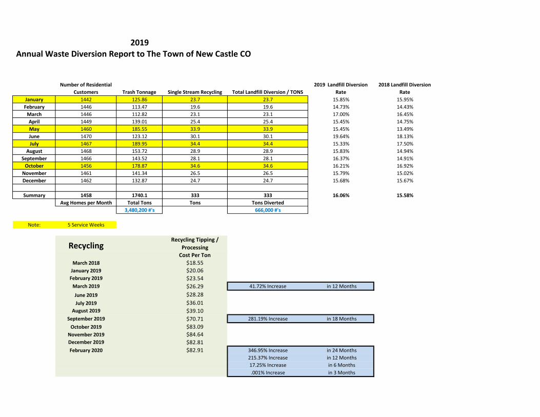


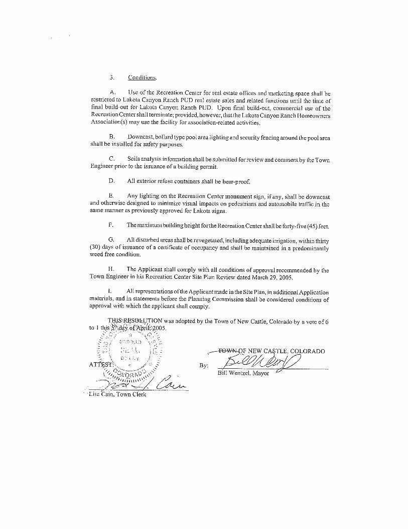


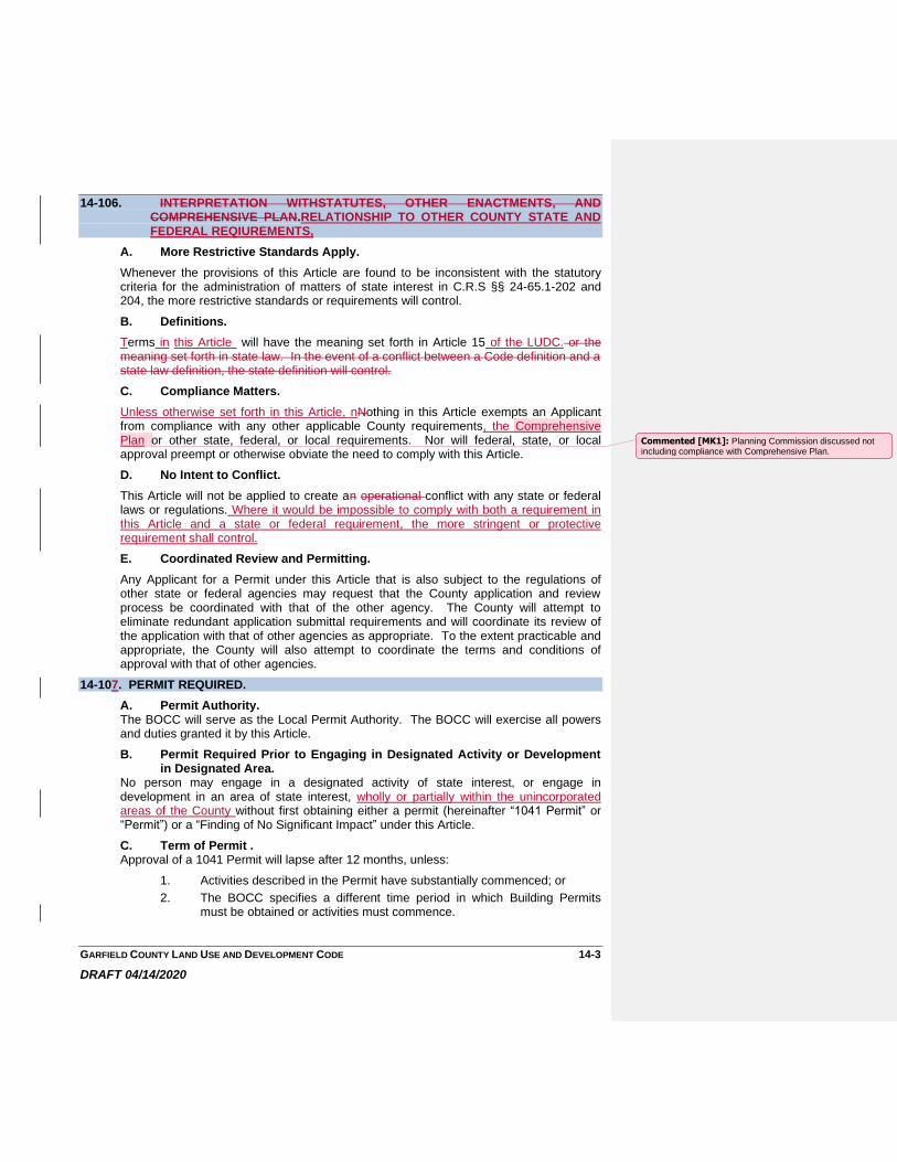


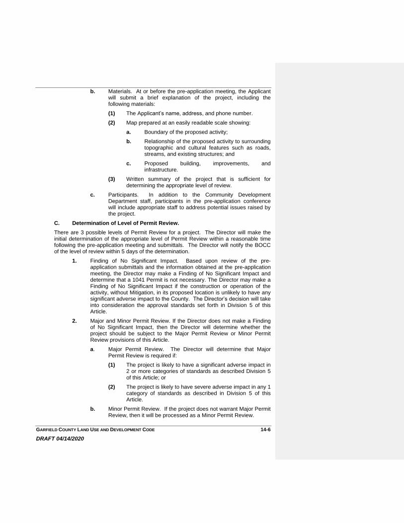


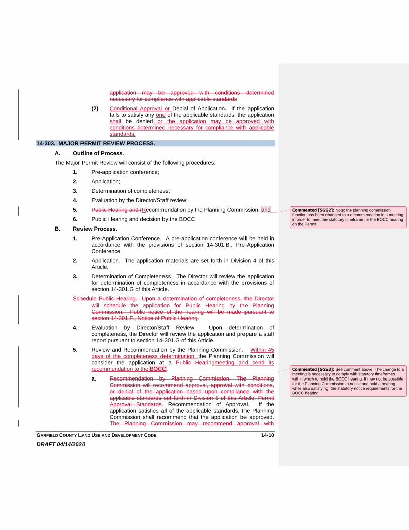


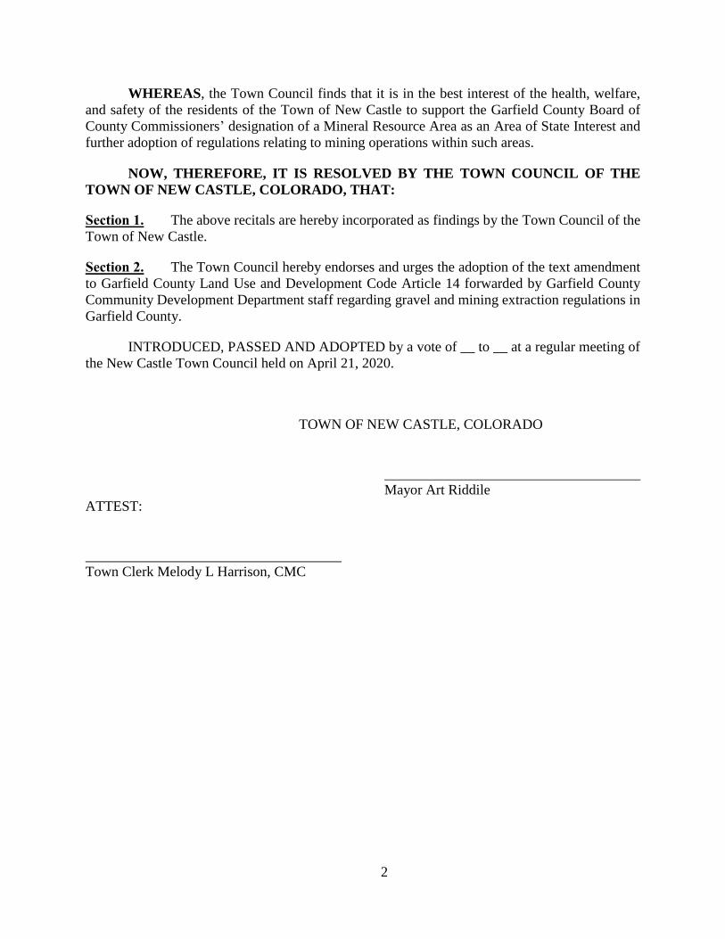


![(fëk) 1257 90002m (3000 RTER 36WYIJ— C]450 130 450 130 450 … · 2013. 11. 19. · (fëk) 1257 90002m (3000 rter 36wyij— c]450 130 450 130 450 87001m bk4204 ( bk4084Ø ieh.2eho¥69,800](https://static.documents.pub/doc/80x56/60cd90ded1e1fd22d973c357/fk-1257-90002m-3000-rter-36wyija-c450-130-450-130-450-2013-11-19-fk.jpg)


