86
Town of New Hampton, New Hampshire Hazard Mitigation Plan Sky Pond Road after the August 2008 rains February 2009

Town of New Hampton, New Hampshire Hazard Mitigation Plan
Sky Pond Road after the August 2008 rains
February 2009


Town of New Hampton, New Hampshire Hazard Mitigation Plan
Prepared by: New Hampton Hazard Mitigation Plan Committee
Jim Boucher Road Agent, Department of Public Works Ken Mertz Planning Board Kirk Beswick Facilities Director, New Hampton School Merritt Salmon Selectman Nathaniel Sawyer Police Chief David Clement Fire Chief Bruce Harvey Interim Fire Chief Fred Smith, Jr. Village Precinct Commissioner
With Assistance from:
Lakes Region Planning Commission 103 Main Street, Suite #3
Meredith, NH 03253 Internet: www.lakesrpc.org
Phone: (603) 279-8171 Fax: (603) 279-0200
February 2009
Funding for this plan was provided by the NH Homeland Security and Emergency Management, and in part by the Lakes Region Planning Commission.
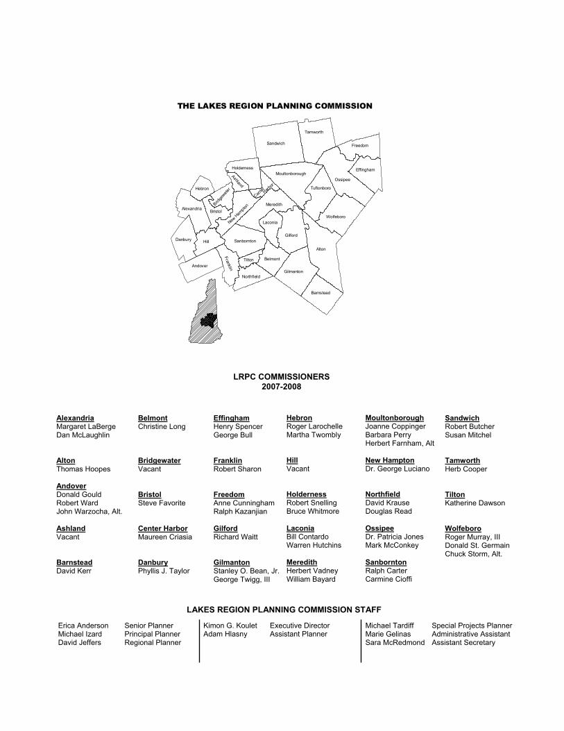
THE LAKES REGION PLANNING COMMISSION
Danbury
Andover
Frankli n
Northfield
Tilton
Hill
Alexandria
Hebron
BristolBrid
gewater
New H
ampton
Sanbornton
Meredith
Laconia
Gilford
Belmont
Gilmanton
Barnstead
Alton
Ashland
Holderness
Sandwich
Tamworth
Freedom
Effingham
OssipeeMoultonborough
Tuftonboro
Wolfeboro
Harbor
Center
Alexandria Margaret LaBerge Dan McLaughlin Alton Thomas Hoopes Andover Donald Gould Robert Ward John Warzocha, Alt. Ashland Vacant Barnstead David Kerr
Belmont Christine Long Bridgewater Vacant Bristol Steve Favorite Center Harbor Maureen Criasia Danbury Phyllis J. Taylor
Effingham Henry Spencer George Bull Franklin Robert Sharon Freedom Anne Cunningham Ralph Kazanjian Gilford Richard Waitt Gilmanton Stanley O. Bean, Jr. George Twigg, III
Moultonborough Joanne Coppinger Barbara Perry Herbert Farnham, Alt New Hampton Dr. George Luciano Northfield David Krause Douglas Read Ossipee Dr. Patricia Jones Mark McConkey Sanbornton Ralph Carter Carmine Cioffi
Sandwich Robert Butcher Susan Mitchel Tamworth Herb Cooper Tilton Katherine Dawson Wolfeboro Roger Murray, III Donald St. Germain Chuck Storm, Alt.
Hebron Roger Larochelle Martha Twombly Hill Vacant Holderness Robert Snelling Bruce Whitmore Laconia Bill Contardo Warren Hutchins Meredith Herbert Vadney William Bayard
LAKES REGION PLANNING COMMISSION STAFF
Erica Anderson Senior Planner Michael Izard Principal Planner David Jeffers Regional Planner
Kimon G. Koulet Executive Director Adam Hlasny Assistant Planner
Michael Tardiff Special Projects PlannerMarie Gelinas Administrative Assistant Sara McRedmond Assistant Secretary
LRPC COMMISSIONERS2007-2008

Town of New Hampton Hazard Mitigation Plan
i
TABLE OF CONTENTS EXECUTIVE SUMMARY.............................................................................................................................iii CHAPTER I: PLANNING PROCESS .......................................................................................................1
A. BACKGROUND..........................................................................................................................1 B. AUTHORITY ...............................................................................................................................1 C. FUNDING SOURCE..................................................................................................................1 D. PURPOSE......................................................................................................................................1 E. SCOPE OF PLAN .......................................................................................................................1 F. METHODOLOGY......................................................................................................................2 G. ACKNOWLEDGMENTS..........................................................................................................3
CHAPTER II: COMMUNITY PROFILE..................................................................................................5 A. DEVELOPMENT TRENDS.....................................................................................................6
CHAPTER III: RISK ASSESSMENT .........................................................................................................9 A. IDENTIFYING HAZARDS .....................................................................................................9
I. Flood, Drought, Extreme Heat, and Wildfire ......................................................9 II. Geological Hazards .................................................................................................13 III. Severe Wind............................................................................................................15 IV. Winter Weather .......................................................................................................19 V. Other Hazards ........................................................................................................20
B. PROFILING HAZARD EVENTS.........................................................................................23 C. HISTORICAL HAZARD EVENTS ......................................................................................28
CHAPTER IV: VULNERABILITY ASSESSMENT...............................................................................33 A. CLASSIFICATION OF CRITICAL INFRASTRUCTURE ..............................................33 B. NATURAL HAZARDS VULNERABILITY OF CRITICAL FACILITIES..................34 C. MANMADE VULNERABILITY OF CRITICAL FACILITIES .....................................35 D. ESTIMATING POTENTIAL LOSSES TO CRITICAL FACILITIES...........................35
CHAPTER V: MITIGATION STRATEGIES ........................................................................................37 A. STATE OF NEW HAMPSHIRE HAZARD MITIGATION GOALS...........................37 B. TOWN OF NEW HAMPTON, NEW HAMPSHIRE HAZARD MITIGATION
GOALS.........................................................................................................................................38 E. IDENTIFICATION AND ANALYSIS OF MITIGATION AND RESPONSE
ACTIONS ....................................................................................................................................46 CHAPTER VI: PLAN ADOPTION AND MONITORING...............................................................56
A. IMPLEMENTATION...............................................................................................................56 B. PLAN MAINTENANCE .........................................................................................................56 C. ADOPTION................................................................................................................................56
APPENDIX A: TECHNICAL RESOURCES .........................................................................................58 APPENDIX B: MITIGATION FUNDING RESOURCES.................................................................60 APPENDIX C: PUBLIC NOTICE EXAMPLE and WEB POSTINGS............................................62 APPENDIX D: POTENTIAL HAZARDS AND CRITICAL FACILITIES MAP...........................68 APPENDIX E: MANMADE/TERRORIST RISK TO CRITICAL FACILITIES ..........................70 APPENDIX F: CRITICAL FACILITIES NATURAL HAZARDS VULNERABILITY
ASSESSMENT............................................................................................................................71 APPENDIX G: RISK ASSESSMENT MATRIX....................................................................................72 APPENDIX H: STAPLEE RESULTS ......................................................................................................74

Town of New Hampton Hazard Mitigation Plan
ii

Town of New Hampton Hazard Mitigation Plan
iii
EXECUTIVE SUMMARY The New Hampton Hazard Mitigation Plan (the Plan) serves as a means to reduce future losses from natural or man-made hazard events before they occur. The Plan was developed by the New Hampton Hazard Mitigation Planning Committee with assistance from the Lakes Region Planning Commission, and contains statements of policy adopted by the Board of Selectmen in Chapter VI. Natural and human hazards for New Hampton are summarized as follows: Moderate Risk
Flood Dam Failure Wildfire Blizzard/Snowstorm Ice Storm Nor’easter Motor Vehicle Accident with Hazardous Materials Oil or Propane Spill The New Hampton Hazard Mitigation Planning Committee, as shown in Chapter IV, identified “Critical Facilities” and “Populations to Protect” as follows: Critical Facilities Populations to Protect
Transfer Station Annie's Place
Town Highway Garage Day Care Center
Town Offices Elderly Housing (under construction)
Village Precinct Sewage Treatment Facility New Hampton School
Transfer Station New Hampton Community School
Town Highway Garage Cistern (private) Direct TV (private communications business) Village Precinct Electrical Substation NH DOT Highway Garage Town Meeting House Police Department Gordon-Nash Library Fire Department Village Precinct Water Facility

Town of New Hampton Hazard Mitigation Plan
iv
The New Hampton Hazard Mitigation Planning Committee identified numerous existing hazard mitigation programs including the following: Emergency Operations Plan School Emergency Plan Local Regulations including: Zoning Ordinances, NFIP, and Subdivision Regulations Police, Fire, and EMS Mutual Aid agreements Equipment inspection and replacement programs
The New Hampton Hazard Mitigation Planning Committee developed a list of one all hazard mitigation action, ten hazard-specific mitigation actions, and thirty-one response actions. These actions were prioritized based on local criteria. Discussions were held regarding how implementation might occur. The results of these discussions are summarized in Table XVI: Implementation Schedule for Mitigation Actions (pages 50 – 55).

Town of New Hampton Hazard Mitigation Plan
1
CHAPTER I: PLANNING PROCESS A. BACKGROUND The Federal Emergency Management Agency (FEMA) has mandated that all communities within the state of New Hampshire establish local hazard mitigation plans as a means to reduce and mitigate future losses from natural or human hazard events. In response to this mandate, the NH Homeland Security and Emergency Management (NH HSEM) and regional planning commissions in the state entered into agreements to aid communities with plan development. The plan development process followed the steps outlined in the Guide to Hazard Mitigation Planning for New Hampshire Communities. B. AUTHORITY This Hazard Mitigation Plan was prepared in accordance with the Planning Mandate of Section 409 of Public Law 93-288 as amended by Public Law 100-707, the Robert T. Stafford Act of 1988, hereinafter referred to as the "Stafford Act." Accordingly, this Hazard Mitigation Plan will be referred to as the "Plan." C. FUNDING SOURCE The New Hampshire Homeland Security and Emergency Management (NH HSEM) funded the Plan with matching funds from the Lakes Region Planning Commission. D. PURPOSE The New Hampton Hazard Mitigation Plan is a planning tool to be used by the town of New Hampton, as well as other local, state and federal governments, in their efforts to reduce the effects from natural and man-made hazards. The Plan contains statements of policy as outlined in the Implementation Schedule for Mitigation Actions (pages 50 – 55). All other sections of this plan are support and documentation for informational purposes only and are not included as a statement of policy. E. SCOPE OF PLAN The scope of this Plan includes the identification of natural hazards affecting the town of New Hampton, as identified by the New Hampton Hazard Mitigation Planning Committee (Committee). The hazards were reviewed under the following categories as outlined in the New Hampshire's Natural Hazards Mitigation Plan:
I. Flood, Wild Land Fire, Drought (Flood, Dam Break, Ice Jam, Wildfire, Drought) II. Geological Hazards (Earthquake, Radon, Landslide). III. Severe Wind (Tornado, Hurricane, Thunderstorm, Lightning, Hail, Downburst). IV. Winter Weather (Blizzard/Snow Storm, Ice Storm, Nor’easter, Avalanche). V. Other Hazards (Motor Vehicle Accident involving Hazardous Materials, Oil Spill,
Military Aircraft Accident, Pandemic, Rabies).

Town of New Hampton Hazard Mitigation Plan
2
F. METHODOLOGY The Lakes Region Planning Commission (LRPC) spoke with the New Hampton Board of Selectmen in February of 2008 about starting the hazard mitigation plan development process. In April of 2008 the New Hampton Hazard Mitigation Planning Committee was established for the purpose of developing a long range plan for hazard mitigation. The Committee consisted of representatives from Fire, Police, Public Works, the Planning Board, the Village Precinct, the New Hampton School, and the Chair of the Selectman. Using the Guide to Hazard Mitigation Planning for New Hampshire Communities, the Committee developed the content of the Plan by following the nine-step process set forth in the handbook. The Committee held meetings starting April 9, 2008 through September 15, 2008 in order to develop and review the Plan. The following timeline shows the dates and corresponding Committee actions. Committee Meetings April 9, 2008 3:00 PM: Informational and organizational meeting held at the New Hampton Town Offices. Step 1: Hazard Mitigation Plan process and Committee organization Step 2: Identify Critical Facilities on base map
Identify Potential Hazards on base map May 12, 2008, 2:30 PM: Working Committee meeting held at the New Hampton Town Offices.
Step 2: Continued Identification of Critical Facilities and Potential Hazards Step 3a: Risk Assessment
Step 4: Analyze Development Trends June 2, 2008, 2:30 PM: Working Committee meeting held at the New Hampton Town Offices.
Step 3a: Risk Assessment (continued) Step 5a: Identify Existing Plans or Policies
July 7, 2008, 2:30 PM: Working Committee meeting held at the New Hampton Town Offices. Step 3a: Risk Assessment (continued)
Step 3b: Vulnerability Assessments Step 5a: Identify Existing Plans or Policies (continued)
July 28, 2008, 2:30 PM: Working Committee meeting held at the New Hampton Town Offices.
Step 3a: Risk Assessment (continued) Step 5a: Identify Existing Plans or Policies (continued)
August 29, 2008, 2:30 PM: Working Committee meeting held at the New Hampton Town Offices.
Step 5b: Identify Existing Gaps in Protection (continued) Step 6: Brainstorm & Evaluate Disaster Minimization Alternatives August 29 – September 8, 2008 Committee reviewed the DRAFT of Chapters 1 – 3 and provided feedback.

Town of New Hampton Hazard Mitigation Plan
3
September 15, 2008, 7:00 PM: Working Committee meeting held at the New Hampton Town Offices.
Step 7: Determine Priorities (STAPLEE) Step 8: Develop Implementation Strategy
September 19 – 29, 2008: Public Review and Comment period. September 30, 2008: Submitted to NH HSEM/FEMA for review. February 2009: Step 9: Adopt & Monitor the Plan Public Involvement Announcements, the agenda for each meeting, and notes of each meeting were posted in town in advance of each meeting. Information about the Hazard Mitigation Plan and invitations for the public to attend were posted prominently on both the LRPC and town of New Hampton websites. EMDs from the neighboring towns of Bristol, Bridgewater, Ashland, Center Harbor, Meredith, Sanbornton, and Hill were also notified of the planning process and invited to participate. The New Hampton website contained the notes and agenda for each meeting. Examples of these are located in Appendix C. In the future Plan revision, press releases should be sent to local and regional papers. The Committee held a public comment period in order to obtain additional feedback. The Plan (including comment instructions) was available for public review at the Town Offices from September 19 – 29, 2008. All comments were to be submitted to the Lakes Region Planning Commission. This provided an opportunity for local and regional businesses, organizations, agencies, educational and health institutions in New Hampton and the surrounding towns to review the plan. G. ACKNOWLEDGMENTS The New Hampton Board of Selectmen extends special thanks to those that assisted in the development of this Plan: Kirk Beswick Facilities Director, New Hampton School Jim Boucher Road Agent, Department of Public Works David Clement Fire Chief* Bruce Harvey Interim Fire Chief* Barbara Lucas New Hampton Town Administrator Ken Mertz Planning Board Hans Mundahl New Hampton School Merritt Salmon Selectman Nathaniel Sawyer Police Chief Fred Smith, Jr. Village Precinct Commissioner Thomas Smith Selectman Paul Tierney Selectman Cindy Richard NH Homeland Security and Emergency Management Field Representative David Jeffers Lakes Region Planning Commission *Chief Clement retired during the Plan development process and was replaced on the Committee by Interim Chief Harvey. Michael Drake was appointed as Fire Chief and EMD in October 2008.

Town of New Hampton Hazard Mitigation Plan
4
Town of New Hampton Hazard Mitigation Plan
5
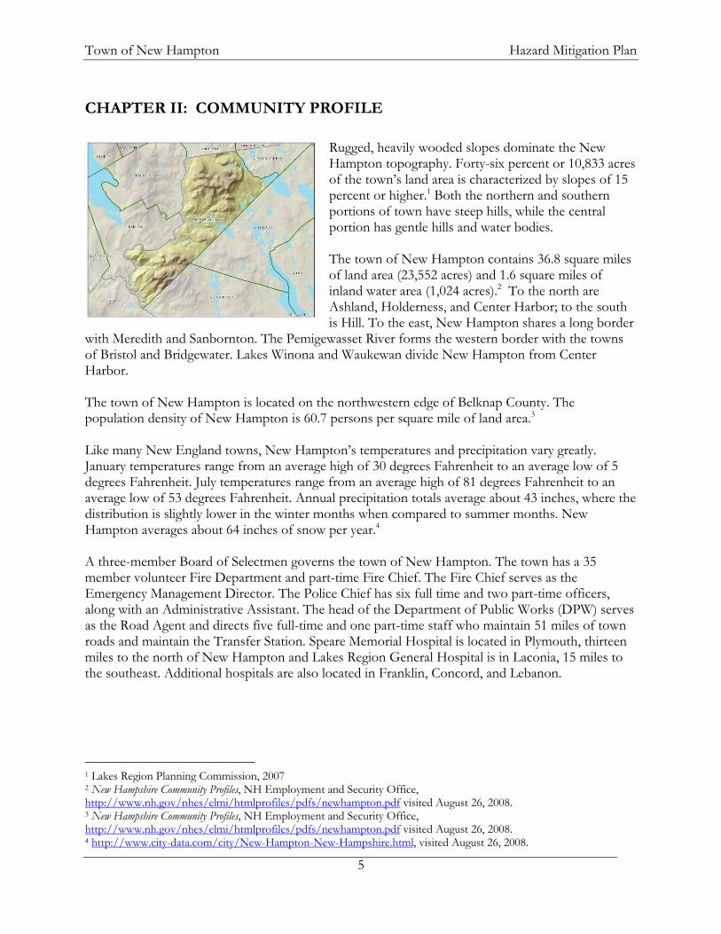
CHAPTER II: COMMUNITY PROFILE
Rugged, heavily wooded slopes dominate the New Hampton topography. Forty-six percent or 10,833 acres of the town’s land area is characterized by slopes of 15 percent or higher.1 Both the northern and southern portions of town have steep hills, while the central portion has gentle hills and water bodies. The town of New Hampton contains 36.8 square miles of land area (23,552 acres) and 1.6 square miles of inland water area (1,024 acres).2 To the north are Ashland, Holderness, and Center Harbor; to the south is Hill. To the east, New Hampton shares a long border
with Meredith and Sanbornton. The Pemigewasset River forms the western border with the towns of Bristol and Bridgewater. Lakes Winona and Waukewan divide New Hampton from Center Harbor. The town of New Hampton is located on the northwestern edge of Belknap County. The population density of New Hampton is 60.7 persons per square mile of land area.3 Like many New England towns, New Hampton’s temperatures and precipitation vary greatly. January temperatures range from an average high of 30 degrees Fahrenheit to an average low of 5 degrees Fahrenheit. July temperatures range from an average high of 81 degrees Fahrenheit to an average low of 53 degrees Fahrenheit. Annual precipitation totals average about 43 inches, where the distribution is slightly lower in the winter months when compared to summer months. New Hampton averages about 64 inches of snow per year.4 A three-member Board of Selectmen governs the town of New Hampton. The town has a 35 member volunteer Fire Department and part-time Fire Chief. The Fire Chief serves as the Emergency Management Director. The Police Chief has six full time and two part-time officers, along with an Administrative Assistant. The head of the Department of Public Works (DPW) serves as the Road Agent and directs five full-time and one part-time staff who maintain 51 miles of town roads and maintain the Transfer Station. Speare Memorial Hospital is located in Plymouth, thirteen miles to the north of New Hampton and Lakes Region General Hospital is in Laconia, 15 miles to the southeast. Additional hospitals are also located in Franklin, Concord, and Lebanon.
1 Lakes Region Planning Commission, 2007 2 New Hampshire Community Profiles, NH Employment and Security Office, http://www.nh.gov/nhes/elmi/htmlprofiles/pdfs/newhampton.pdf visited August 26, 2008. 3 New Hampshire Community Profiles, NH Employment and Security Office, http://www.nh.gov/nhes/elmi/htmlprofiles/pdfs/newhampton.pdf visited August 26, 2008. 4 http://www.city-data.com/city/New-Hampton-New-Hampshire.html, visited August 26, 2008.

Town of New Hampton Hazard Mitigation Plan
6
A. DEVELOPMENT TRENDS Population, Housing Stock, and Growth Patterns The population of New Hampton grew by 28.6% between 1980 and 1990. Between 1990 and 2000, the increase in population in New Hampton slowed from the preceding decade (21.4% increase), however, it was still the ninth fastest growing community in the region during the 1990s.5 Table I illustrates the population growth in New Hampton from 2001-2006.6 Current projections from the NH Office of Energy and Planning (OEP) show the anticipated growth in New Hampton over the next twenty years; where the year-round population in 2025 is projected to be 2,680 residents (Table II).7 New Hampton has a lower median age (38.3 years in 2000) than the Belknap County average (40.1 years) but higher than the state-wide average (37.1 years). During the 1990s, the median age in New Hampton jumped from 34.0 to 38.3 years.8 The estimated percentage of seasonal homes in New Hampton in 2000 (19.1%) was nearly double the statewide average (10.3%), lower than the Lakes Region as a whole (29.8%), and lower than Belknap County rates (26.7%) for seasonal homes.9 These development trends indicate the possibility of several challenges for local mitigation efforts. The number of seasonal residential units is indicative of people from varying origins spending a portion of their time in the community. The challenge this presents is in providing adequate information to all community members regarding the town’s rules and procedures, which can vary from those in seasonal residents’ towns of origin. For example, fire safety information for the influx of summer residents can be of great value, not only for the high instances of campfires, but also for the general fire safety guidelines for residences in wooded areas. Another possible challenge in dealing with hazardous events is the potential for increased special needs populations. Those typically most at risk from severe weather events are the elderly and young children. Given the increasing age of the population, the likelihood of having additional residents with special medical needs is high. 5 Lakes Region Demographic Profile. Lakes Region Planning Commission, 2003, p.3. 6 http://nhetwork.nhes.state.nh.us/nhetwork/Population.aspx?sid=18, visited August 26, 2008. 7 Municipal Population Projections 2010 to 2030. NH Office of Energy and Planning, http://www.nh.gov/oep/programs/DataCenter/Population/documents/MunicipalPopulationProjections2010-2030.pdf, visited August 21, 2008. 8 Lakes Region Demographic Profile. Lakes Region Planning Commission, 2003, p. 6-10. 9 Lakes Region Demographic Profile. Lakes Region Planning Commission, 2003, p. 18-19.
Table I: New Hampton Population
Time Period Population
2002 2,019 2003 2,065 2004 2,104 2005 2,131 2006 2,135 2007 2,151 Table II: New Hampton Population Projection
Time Period Population
2010 2,330 2015 2,440 2020 2,560 2025 2,680

Town of New Hampton Hazard Mitigation Plan
7
Future Development The NH OEP estimates the population of New Hampton will be 2,330 in 2010. Although the number of permits issued has slowed since 2005, evidence of recent growth can be seen by the number of building permits issued annually (Table III).10 New Hampton does have a distinct Village Center; known as the Village Precinct District which has special zoning. Water, sewer, and electrical services are managed by the Precinct Commissioners. Development does tend to occur in a linear fashion along existing roads. Aside from the Village Precinct, more development has occurred to the north of NH Route 104 than to the south. Much of the remainder of New Hampton remains undeveloped.
10 Development Activity in the Lakes Region: 2008 Annual Report. p. 15. Lakes Region Planning Commission, 2008.
Table III: Number of Residential Building Permits in New Hampton Year Number of Permits
2000 46 2001 15 2002 25 2003 24 2004 22 2005 15 2006 16

Town of New Hampton Hazard Mitigation Plan
8

Town of New Hampton Hazard Mitigation Plan
9
CHAPTER III: RISK ASSESSMENT A. IDENTIFYING HAZARDS The town of New Hampton is prone to a variety of man-made and natural hazards. The Committee used the state-wide 2004 Natural Hazard Mitigation Plan, developed by the New Hampshire Governor’s Office of Emergency Management, to identify all hazards that could affect the Lakes Region.11 The Committee also reviewed plans, ordinances, land use regulations, university databases, and internet sources for information about past hazard events in New Hampton. The State Hazard Mitigation Planning Committee identified several natural hazards that have the potential to impact the State. Table IV provides a summary of previous occurrences and severity of these hazards.12 The following narratives provide an overview for the hazards most likely to impact the Lakes Region.
Table IV: Frequency & Severity of Hazards in New Hampshire Natural Hazard Frequency Severity Flooding High High Dam Failure Low Moderate Drought Low Moderate Wildfire High Low Earthquake Low Low Landslide Low Low Radon Moderate Low Tornado/Downburst Moderate Moderate Hurricane Moderate High Lightning Moderate Low Severe Winter Weather High High Snow Avalanche Low Low
I. Flood, Drought, Extreme Heat, and Wildfire Flooding Floods are defined as a temporary overflow of water onto lands that are not normally covered by water. It results from the overflow of rivers and tributaries or inadequate drainage. Flooding in the Lakes Region is most commonly associated with structures and properties located within a floodplain. There are numerous rivers and streams within the region and significant changes in elevation, leading to some fast-moving water. The region also has a great deal of shoreline, making it exposed to rising water levels as well. Although historically there have not been high instances of shoreline flooding, the potential always exists for a major flood event to occur. Recent rain events have proven this is becoming an increasing concern as additional development is contributing to
11 http://www.nh.gov/safety/divisions/bem/HazardMitigation/documents/Chapter_IV_Risk_Assessment.pdf, visited November 1, 2007. 12 http://www.nh.gov/safety/divisions/bem/HazardMitigation/documents/Chapter_III_Hazard_Analysis.pdf, visited November 1, 2007.

Town of New Hampton Hazard Mitigation Plan
10
flood hazards. As areas are covered with impervious surfaces, less water is allowed to infiltrate. This causes more likelihood of flash floods and sheet flow. Of greatest concern are the waterfront properties on the lakes, ponds, and associated tributaries. Culvert and roadwork has been conducted throughout the region as a result of localized flooding events. Of particular concern in the region are areas of steep slopes and soils with limited capacity to accept volumes of rainwater rapidly. Roads and culverts in close proximity to these conditions are most at risk of localized flooding. Dam Failure
Dam failure results in rapid loss of water that is normally held back by a dam. These types of floods can be extremely dangerous and pose a threat to both life and property. Dam classifications in New Hampshire are based on the degree of potential damages that a dam failure is expected to cause. There are four levels of dam classification in New Hampshire: Non-Menace, Low Hazard, Significant Hazard, and High Hazard.
“Non Menace structure means that failure or misoperation of the dam would not result in probable loss of life or loss to property. Low Hazard structure means that failure or misoperation of the dam would result in any of the following:
- No possible loss of life.
- Low economic loss to structures or property.
- Structural damage to a town or city road, or private road accessing property other than the dam owner’s, that could render the road impassable or otherwise interrupt public safety services.
- The release of liquid industrial, agricultural, or commercial wastes, septage, or contaminated sediment if the storage capacity is less than two-acre-feet and is located more than 250 feet from a water body or water course.
- Reversible environmental losses to environmentally-sensitive sites.
Significant Hazard structure means a dam that has a significant hazard potential because it is in a location and of a size that failure or misoperation of the dam would result in any of the following:
- No probable loss of life.
- Major economic loss to structures or property.
- Structural damage to a Class I or Class II road that could render the road impassable or otherwise interrupt public safety services.
- Major environmental or public health losses, including one or more of the following:
• Damage to a public water system, as defined by RSA 485:1-a, XV, which will take longer than 48 hours to repair.

Town of New Hampton Hazard Mitigation Plan
11
• The release of liquid industrial, agricultural, or commercial wastes, septage, sewage, or contaminated sediments if the storage capacity is 2 acre-feet or more.
• Damage to an environmentally-sensitive site that does not meet the definition of reversible environmental losses.
High Hazard means a dam that has a high hazard potential because it is in a location and of a size that failure or misoperation of the dam would result in probable loss of human life.” 13 The hazard potential for dams relates to damage that would occur if the dam were to break – not the structural integrity of the dam itself. In the Lakes Region, the Town of Alton was impacted by an earthen dam failure on March 12, 1996. Although listed in the NH Hazard Mitigation Plan as a significant hazard, it did result in the loss of one life.
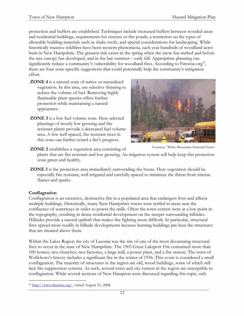
Ice Jam Ice forming in riverbeds and against structures often presents significant hazardous conditions for communities. Meltwater or stormwater may encounter these ice formations and apply lateral and/or vertical force upon structures. Moving ice may scour abutments and riverbanks. Ice may also create temporary dams. These dams can create flood hazard conditions where none previously existed. According to the US Army Corps of Engineers (USACE) Cold Regions Research and Engineering Laboratory (CRREL)14, the Pemigewasset River ranks second in the state for the number of ice events (>35) prior to 2000. In order to reduce flooding potential and damage to bridges and structures, USACE has constructed dams and ice diversion structures to slow the large ice formations. Wildfire A wildfire is defined as a fire in wooded, potentially remote areas that may endanger lives. New Hampshire has about 500 wild land fires each year; most of these burn less than half an acre. Much of the Lakes Region is forested and susceptible to fire. A present concern of NH Department of Resources and Economic Development (DRED) Division of Forests & Lands is that the Ice Storm of 1998 has left a significant amount of woody debris in the forests of the region that may fuel future wildfires.15 Several areas in the region are relatively remote in terms of access and fire fighting abilities. Of greatest concern are those areas characterized by steep slopes and vast woodlands, with limited vehicular access. These areas include parts of northern and southern New Hampton. As these once remote areas begin to see more development, care should be taken to ensure that adequate fire
13 http://www.des.state.nh.us/factsheets/dam/db-15.htm. Visited August 22, 2008. 14 http://www.crrel.usace.army.mil/home-products.html. Visited November 1, 2007. 15 Summary of State Wildfire Burns. NH Office of Emergency Management (Table of Tables), June 22, 2007, http://www.nhoem.state.nh.us/mitigation/default.htm.
Alton earthen dam failure
Town of New Hampton Hazard Mitigation Plan
12
protection and buffers are established. Techniques include increased buffers between wooded areas and residential buildings, requirements for cisterns or fire ponds, a restriction on the types of allowable building materials such as shake roofs, and special considerations for landscaping. While historically massive wildfires have been western phenomena, each year hundreds of woodland acres burn in New Hampshire. The greatest risk exists in the spring when the snow has melted and before the tree canopy has developed, and in the late summer – early fall. Appropriate planning can significantly reduce a community’s vulnerability for woodland fires. According to Firewise.org16, there are four zone-specific suggestions that could potentially help the community’s mitigation effort. ZONE 4 is a natural zone of native or naturalized
vegetation. In this area, use selective thinning to reduce the volume of fuel. Removing highly flammable plant species offers further protection while maintaining a natural appearance.
ZONE 3 is a low fuel volume zone. Here selected plantings of mostly low growing and fire resistant plants provide a decreased fuel volume area. A few well-spaced, fire resistant trees in this zone can further retard a fire's progress.
ZONE 2 establishes a vegetation area consisting of plants that are fire resistant and low growing. An irrigation system will help keep this protection zone green and healthy.
ZONE 1 is the protection area immediately surrounding the house. Here vegetation should be especially fire resistant, well irrigated and carefully spaced to minimize the threat from intense flames and sparks.
Conflagration Conflagration is an extensive, destructive fire in a populated area that endangers lives and affects multiple buildings. Historically, many New Hampshire towns were settled in areas near the confluence of waterways in order to power the mills. Often the town centers were at a low point in the topography, resulting in dense residential development on the steeper surrounding hillsides. Hillsides provide a natural updraft that makes fire fighting more difficult. In particular, structural fires spread more readily in hillside developments because burning buildings pre-heat the structures that are situated above them. Within the Lakes Region the city of Laconia was the site of one of the most devastating structural fires to occur in the state of New Hampshire. The 1903 Great Lakeport Fire consumed more than 100 homes; two churches, two factories, a large mill, a power plant, and a fire station. The town of Wolfeboro’s history includes a significant fire in the winter of 1956. This event is considered a small conflagration. The majority of structures in the region are old, wood buildings, some of which still lack fire suppression systems. As such, several town and city centers in the region are susceptible to conflagration. While several sections of New Hampton were discussed regarding this topic, only 16 http://www.firewise.org/, visited August 21, 2008.
Courtesy: White Mountains National Forest

Town of New Hampton Hazard Mitigation Plan
13
Jellystone Campground, a seasonal camping area with many small, closely packed cottages was identified as a potential conflagration area. Drought Drought occurs when less than the normal amount of water is available for extended periods of time. Effects may include decreased soil moisture, groundwater levels, streamflow, and lake, pond, and well levels may drop. Factors that may contribute to drought include reduced rain/snowfall, increased rates of evaporation, and increased water usage. New Hampshire generally receives adequate rainfall; it is rare that the state experiences extended periods of below normal water supplies. Since 1990 New Hampshire has had a state Drought Emergency Plan, which identifies four levels of action indicating the severity of the drought: Alert, Warning, Severe, and Emergency. There have been five extended droughts in New Hampshire in the past century: 1929 – 1936, 1939 – 1944, 1947 – 1950, 1960 – 1969, and 2001 – 200217.
II. Geological Hazards Earthquake An earthquake is a series of vibrations induced in the Earth’s crust by the abrupt rupture and rebound of rocks in which elastic strain has been slowly accumulating. Earthquakes are commonly measured using magnitude, or the amount of seismic energy released at the epicenter of the earthquake. The Richter magnitude scale is a mathematical device used to compare the size of earthquakes, shown in Table V.18
Table V: Richter Magnitude Scale Magnitude Earthquake Effects 2.5 or less Usually not felt, but can be recorded by seismograph. 2.5 to 5.4 Often felt, but only causes minor damage. 5.5 to 6.0 Slight damage to buildings and other structures. 6.1 to 6.9 May cause a lot of damage in very populated areas. 7.0 to 7.9 Major earthquake. Serious damage. 8.0 or greater Great earthquake. Can totally destroy communities near the
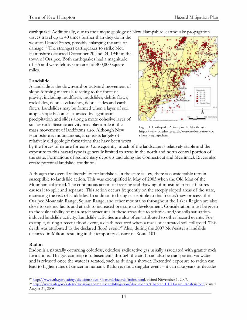
epicenter. New Hampshire is considered to be in an area of moderate seismic activity with respect to other regions of the country. This means the state could experience large (6.5-7.0 magnitude) earthquakes, but they are not likely to occur as frequently as in a high hazard area like the Pacific coast. On average, every other year the Lakes Region experiences an earthquake, though these earthquakes are mild and go mostly undetected by people. Figure I shows an arc of earthquake activity over the New Hampshire Lakes Region that concerns the emergency management community. According to the US Geologic Survey, the overall earthquake risk to the state is high due to the built environment; which means that many structures in the state are old or not built to withstand an 17 http://www.nh.gov/safety/divisions/bem/HazardMitigation/documents/Chapter_III_Hazard_Analysis.pdf, visited April 24, 2008. 18 http://pubs.usgs.gov/gip/earthq4/severitygip.html, visited August 15, 2007.
Town of New Hampton Hazard Mitigation Plan
14
earthquake. Additionally, due to the unique geology of New Hampshire, earthquake propagation waves travel up to 40 times further than they do in the western United States, possibly enlarging the area of damage.19 The strongest earthquakes to strike New Hampshire occurred December 20 and 24, 1940 in the town of Ossipee. Both earthquakes had a magnitude of 5.5 and were felt over an area of 400,000 square miles. Landslide A landslide is the downward or outward movement of slope-forming materials reacting to the force of gravity, including mudflows, mudslides, debris flows, rockslides, debris avalanches, debris slides and earth flows. Landslides may be formed when a layer of soil atop a slope becomes saturated by significant precipitation and slides along a more cohesive layer of soil or rock. Seismic activity may play a role in the mass movement of landforms also. Although New Hampshire is mountainous, it consists largely of relatively old geologic formations that have been worn by the forces of nature for eons. Consequently, much of the landscape is relatively stable and the exposure to this hazard type is generally limited to areas in the north and north central portion of the state. Formations of sedimentary deposits and along the Connecticut and Merrimack Rivers also create potential landslide conditions. Although the overall vulnerability for landslides in the state is low, there is considerable terrain susceptible to landslide action. This was exemplified in May of 2003 when the Old Man of the Mountain collapsed. The continuous action of freezing and thawing of moisture in rock fissures causes it to split and separate. This action occurs frequently on the steeply sloped areas of the state, increasing the risk of landslides. In addition to being susceptible to this freeze/thaw process, the Ossipee Mountain Range, Squam Range, and other mountains throughout the Lakes Region are also close to seismic faults and at risk to increased pressure to development. Consideration must be given to the vulnerability of man-made structures in these areas due to seismic- and/or soils saturation-induced landslide activity. Landslide activities are also often attributed to other hazard events. For example, during a recent flood event, a death occurred when a mass of saturated soil collapsed. This death was attributed to the declared flood event.20 Also, during the 2007 Nor’easter a landslide occurred in Milton, resulting in the temporary closure of Route 101. Radon Radon is a naturally occurring colorless, odorless radioactive gas usually associated with granite rock formations. The gas can seep into basements through the air. It can also be transported via water and is released once the water is aerated, such as during a shower. Extended exposure to radon can lead to higher rates of cancer in humans. Radon is not a singular event – it can take years or decades
19 http://www.nh.gov/safety/divisions/bem/NaturalHazards/index.html, visited November 1, 2007. 20 http://www.nh.gov/safety/divisions/bem/HazardMitigation/documents/Chapter_III_Hazard_Analysis.pdf, visited August 21, 2008.
Figure I: Earthquake Activity in the Northeast. http://www.bc.edu/research/westonobservatory/northeast/eqmaps.html

Town of New Hampton Hazard Mitigation Plan
15
to see the effects. The NH Office of Community and Public Health’s Bureau of Radiological Health indicates that one third of homes in New Hampshire have indoor radon levels that exceed the US Environmental Protection Agency’s “action level” of 4 pCi/l.21 Table VI lists the indoor radon test levels for the four counties comprising the Lakes Region. New Hampton is in Belknap County, which has the lowest levels of radon among the four counties.
Table VI: Short-term Indoor Radon Test Results in NH’s Radon Database (May 7, 1999) County # of Tests Maximum %>4.0 pCi/l Belknap 744 22.3 14.1 Carroll 1,042 478.9 45.4 Grafton 1,286 174.3 23.2 Merrimack 1,961 152.8 25.2
III. Severe Wind The Lakes Region is at risk of several types of natural events associated with high winds, including nor’easters, downbursts, hurricanes and tornadoes. Figure II indicates the building standards that should be implemented in the various wind zones throughout the country. The northeast is located in a zone that should be built to withstand 160 mile an hour wind gusts. A large portion of the northeast, including the Lakes Region, is in a designated hurricane susceptible region. Tornado/Downburst On average, six tornadoes per year touch down somewhere in New England. There is no way of knowing where or when the next damaging tornado will strike as they are among the most unpredictable weather phenomena. Tornadoes are violent rotating storms that extend to the ground with winds that can reach 300 miles per hour. They are produced from thunderstorms and can uproot trees and buildings. Although tornadoes are locally produced, damage paths can be in excess of one mile wide and 50 miles long.22 The Fujita Scale is used to measure the intensity of a tornado 21 http://www.nh.gov/safety/divisions/bem/HazardMitigation/documents/Chapter_III_Hazard_Analysis.pdf, visited August 21, 2008. 22 FEMA Hazards: Tornadoes, http://www.fema.gov/business/guide/section3e.shtm, visited November 1, 2007.
Figure II. http://www.fema.gov/plan/prevent/saferoom/tsfs02_wind_zones.shtm

Town of New Hampton Hazard Mitigation Plan
16
(or downburst) by examining the damage caused in the aftermath, shown in Table VII.23 An F2 tornado ripped through a 5-mile section of central NH in July of 2008 from Epsom to Ossipee, leading to requests for federal disaster declarations in several counties24. Table VII: The Fujita Scale F-Scale #
Intensity Phrase Wind Speed Type of Damage
F0 Gale tornado 40-72 mph Some damage to chimneys; breaks branches off trees; pushes over shallow-rooted trees; damages sign boards.
F1 Moderate tornado 73-112 mph The lower limit is the beginning of hurricane wind speed; peels surface off roofs; mobile homes pushed off foundations or overturned; moving autos pushed off the roads; attached garages may be destroyed.
F2 Significant tornado 113-157 mph Considerable damage. Roofs torn off frame houses; mobile homes demolished; boxcars pushed over; large trees snapped or uprooted; light object missiles generated.
F3 Severe tornado 158-206 mph Roof and some walls torn off well constructed houses; trains overturned; most trees in forest uprooted.
F4 Devastating tornado 207-260 mph Well-constructed houses leveled; structures with weak foundations blown off some distance; cars thrown and large missiles generated.
F5 Incredible tornado 261-318 mph Strong frame houses lifted off foundations and carried considerable distances to disintegrate; automobile sized missiles fly through the air in excess of 100 meters; trees debarked; steel reinforced concrete structures badly damaged.
F6 Inconceivable tornado 319-379 mph These winds are very unlikely. The small area of damage they might produce would probably not be recognizable along with the mess produced by F4 and F5 wind that would surround the F6 winds. Missiles, such as cars and refrigerators would do serious secondary damage that could not be directly identified as F6 damage. If this level is ever achieved, evidence for it might only be found in some manner of ground swirl pattern, for it may never be identifiable through engineering studies.
Source: http://www.tornadoproject.com/fscale/fscale.htm
According to the National Oceanic and Atmospheric Administration (NOAA) a downburst is a strong downdraft, rotational in nature, which causes damaging winds on or near the ground. Winds can exceed 130 mph.25 Downbursts are 10 times more likely to occur than tornadoes and fall into two categories based on their size:
microbursts, which cover an area less than 2.5 miles in diameter, and macrobursts, which cover an area at least 2.5 miles in diameter.
The major damage from downbursts come from falling trees, which may take down power lines, block roads, or damage structures and vehicles. New Hampshire experienced three such events in
23 http://www.tornadoproject.com/fscale/fscale.htm, visited August 15, 2007. 24 July 28, 2008 request for federal disaster declaration on NH state website http://www.governor.nh.gov/news/2008/072808_president.htm visited August 27, 2008. 25 Weather Glossary. National Oceanic and Atmospheric Administration, http://www.srh.noaa.gov/fwd/glossarymain.html, visited June 21, 2007.

Town of New Hampton Hazard Mitigation Plan
17
the 1990s. One event occurred in Moultonborough on July 26, 1994 and was classified as a macroburst. It affected an area one-half mile wide by 4-6 miles in length. The tornado/downburst risk for an individual community in New Hampshire is relatively low compared to many other parts of the country. Though the danger that these storms present may be high, the frequency of these storms is relatively low to moderate. However, on July 24, 2008 a tornado affected ten New Hampshire communities including several in southern Belknap County.
Image: Damage from the July 24, 2008 Tornado http://www.nh.gov/safety/divisions/bem/PhotoLibrary/nh_tornado
2008_pg1.htm Hurricane Hurricanes are severe tropical storms that have winds at least 74 miles per hour. In the Lakes Region they could produce heavy rain and strong winds that could cause flooding or damage buildings, trees, power lines, and cars.26 Hurricanes are measured by the Saffir-Simpson Hurricane Scale: a 1-5 rating based on a hurricane's intensity using wind speed as the determining factor (Table VIII). The scale is used to give an estimate of the potential property damage and flooding expected from a hurricane landfall.
Table VIII: Saffir-Simpson Hurricane Scale Category Characteristics
1 Winds 74-95 mph (64-82 kts or 119-153 km/hr). Storm surge generally 4-5 ft above normal. No real damage to building structures. Damage primarily to unanchored mobile homes, shrubbery, and trees. Some damage to poorly constructed signs. Also, some coastal road flooding and minor pier damage.
2 Winds 96-110 mph (83-95 kts or 154-177 km/hr). Storm surge generally 6-8 feet above normal. Some roofing material, door, and window damage of buildings. Considerable damage to shrubbery and trees with some trees blown down. Considerable damage to mobile homes, poorly constructed signs, and piers. Coastal and low-lying escape routes flood 2-4 hours before arrival of the hurricane center. Small craft in unprotected anchorages break moorings.
3 Winds 111-130 mph (96-113 kts or 178-209 km/hr). Storm surge generally 9-12 ft above normal. Some structural damage to small residences and utility buildings with a minor amount of curtainwall failures. Damage to shrubbery and trees with foliage blown off trees and large trees blown down. Mobile homes and poorly constructed signs are destroyed. Low-lying escape routes are cut by rising water 3-5 hours before arrival of the center of the hurricane. Flooding near the coast destroys smaller structures with larger structures damaged by battering from floating debris. Terrain continuously lower than 5 ft above mean sea level may be flooded inland 8 miles (13 km) or more. Evacuation of low-lying residences with several blocks of the shoreline may be required.
26 http://www.fema.gov/hazard/hurricane/hu_about.shtm, visited November 1, 2007.

Town of New Hampton Hazard Mitigation Plan
18
Category Characteristics
4 Winds 131-155 mph (114-135 kts or 210-249 km/hr). Storm surge generally 13-18 ft above normal. More extensive curtainwall failures with some complete roof structure failures on small residences. Shrubs, trees, and all signs are blown down. Complete destruction of mobile homes. Extensive damage to doors and windows. Low-lying escape routes may be cut by rising water 3-5 hours before arrival of the center of the hurricane. Major damage to lower floors of structures near the shore. Terrain lower than 10 ft above sea level may be flooded requiring massive evacuation of residential areas as far inland as 6 miles (10 km).
5 Winds greater than 155 mph (135 kts or 249 km/hr). Storm surge generally greater than 18 ft above normal. Complete roof failure on many residences and industrial buildings. Some complete building failures with small utility buildings blown over or away. All shrubs, trees, and signs blown down. Complete destruction of mobile homes. Severe and extensive window and door damage. Low-lying escape routes are cut by rising water 3-5 hours before arrival of the center of the hurricane. Major damage to lower floors of all structures located less than 15 ft above sea level and within 500 yards of the shoreline. Massive evacuation of residential areas on low ground within 5-10 miles (8-16 km) of the shoreline may be required.
Source: http://www.nhc.noaa.gov/aboutsshs.shtml
On September 21, 1938, a Category 3 hurricane claimed 13 lives in New Hampshire and many more throughout New England. Official records at the Weather Bureau in Concord show sustained winds of 56 miles per hour, but around the state, gusts around 100 miles per hour were reported, mostly due to topographical acceleration. The Merrimack River rose nearly 11 feet above its flood stage, The Hanover Gazette reported that in New Hampshire, 60,000 people were homeless and many areas were without power. Damages were estimated at $22 million.27 Thunderstorm/Lightning Thunderstorms have several threats associated with them including heavy rain, high wind, and hail. In a heavy rain storm, large amounts of rain may fall in a short period of time, severely impacting roads and low-lying developments. All thunderstorms contain lightning, which can cause death, injury, and property damage and have great potential to cause structure and wildfires. The discharge of lightning causes an intense sudden heating of air. The air rapidly expands when heated then contracts as it cools, causing a shock wave that we hear as thunder. This shock wave is sometimes powerful enough to damage windows and structures. On average, more people are killed in the US each year by lightning than any other weather event. Lightning damages cost the insurance industry more than $5 billion annually in the United States.28 In the Lakes Region, however, fewer than two lightning strikes occur per square kilometer annually.29 While this value is not particularly high, the concern that lightning might ignite a wildfire is quite high since a large percentage of the area is rural and forested. Hail High winds can bring down limbs and trees, knocking out electricity and blocking roads. Hail can cause damage to crops and structural damage to vehicles. Hail is measured by the TORRO intensity scale, shown in Table IX. Although hailstorms are not particularly common in the Lakes Region,
27 http://www.nh.gov/safety/divisions/bem/NaturalHazards/index.html, visited November 1, 2007. 28National Lightning Safety Institute webpage, http://www.lightningsafety.com/nlsi_lls/nlsi_annual_usa_losses.htm ,visited November 1, 2007. 29 Northeast States Emergency Consortium, http://www.serve.com/NESEC/, visited August 14, 2007.

Town of New Hampton Hazard Mitigation Plan
19
which averages fewer than two hailstorms per year, several have occurred in New Hampshire in the last few years.30
Table IX: TORRO Hailstorm Intensity Scale Code Diameter Description Typical Damage H0 5-9 mm* Pea No damage H1 10-15 mm Mothball Slight damage to plants, crops H2 16-20 mm Marble, grape Significant damage to fruit, crops, vegetation H3 21-30 mm Walnut Severe damage to fruit and crops, damage to glass and plastic
structures, paint and wood scored H4 31-40 mm Pigeon's egg Widespread glass damage, vehicle bodywork damage H5 41-50 mm Golf ball Wholesale destruction of glass, damage to tiled roofs, significant risk
of injuries H6 51-60 mm Hen’s egg Aircraft bodywork dented, brick walls pitted H7 61-75 mm Tennis ball Severe roof damage, risk of serious injuries H8 76-90 mm Large orange Severe damage to aircraft bodywork H9 91-100 mm Grapefruit Extensive structural damage. Risk of severe or even fatal injuries to
persons caught in the open H10 >100 mm Melon Extensive structural damage. Risk of severe or even fatal injuries to
persons caught in the open *mm = millimeters (Approximate range since other factors (e.g. number, density of hailstones, hail fall speed, surface wind speed) affect severity Source: http://www.torro.org.uk/torro/severeweather/hailscale.php
IV. Winter Weather
Severe winter weather occurs frequently in the northeast and the possibility exists for residents to have to withstand several days without power. It is felt that no one area of the region is at greater risk than another, but there are segments of the population that are more at risk. These include the elderly, people that are in need of regular medical care, and young children. Blizzard/Snow Storm A heavy snowstorm can be defined as one which deposits four or more inches of snow in a twelve hour period.31 Heavy snows can cause damage to property, disrupt services, and make for unsafe travel, even for emergency responders. Due to poor road conditions, residents may be stranded for several days. Extra pressure is placed on road crews and emergency services under these conditions. Snow load in severe winter storms is of concern as well. This is particularly true for flat roofed structures. Several small storms can produce the same snow load as a single larger storm and the combined weight of the snow load can damage rooftops. Ice adds additional weight as well. It is not uncommon in New Hampshire to experience mixes of winter precipitation as temperatures fluctuate above and below the freezing mark. While not widespread, instances of collapsed roofs are not uncommon. Snowstorms are a common occurrence throughout the Lakes Region. Blizzards, which may dump 12” – 36” or more of snow in a one- to three-day period are less frequent, but can have a serious impact on structures, utilities, and services. The region typically receives greater than 66” of snow annually – between 1955 and 1985 the mean annual snowfall was between 6.5 and 8.0 feet. 32 30 National Climactic Data Center, http://www4.ncdc.noaa.gov/cgi-win/wwcgi.dll?wwevent~storms visited 10/4/07. 31 State of New Hampshire Natural Hazards Mitigation Plan. NH Office of Energy and Planning, April 30, 2008. http://www.nh.gov/safety/divisions/bem/HazardMitigation/documents/IIIHazardAnalysis.pdf 32 Northeast States Emergency Consortium, http://www.serve.com/NESEC/, visited June 20, 2007.

Town of New Hampton Hazard Mitigation Plan
20
Ice Storm An ice storm coats trees, power lines, streets, vehicles, and roofs with a very slick and heavy coating of ice. The major threats to a community due to ice storms include structural damage due to heavy loads on roofs, interruptions of services such as electricity, fuel, water, and communications, as well as hazardous road conditions. In the winter of 1998, a major ice storm crippled much of New Hampshire, coating everything with as much as three inches of ice. This storm was the most costly FEMA/Presidential Declared disaster in New Hampshire's history. The ice load bent trees and power lines and led to massive power outages throughout the state. The U.S. Army Corps of Engineers, Cold Regions Research and Engineering Laboratory estimates a 40 – 90 year return period for an event with a uniform ice thickness of between .75 and 1.25 inches. Nor’easter New Hampshire generally experiences at least 1 or 2 nor’easters each year with varying degrees of severity. A nor’easter is defined as a large anticyclone weather system that resides near the New England region. These storms have the potential to inflict more damage than many hurricanes because high winds can last from 12 hours to 3 days, while the duration of hurricanes ranges from 6 to 12 hours. A nor’easter also has the potential to sustain hurricane force winds, produce torrential rain, and create blizzard conditions in winter months. Infrastructure, including critical facilities, may be impacted by these events, and power outages, communications, and transportation disruptions (i.e., snow and/or debris-impacted roads, as well as hazards to navigation and aviation) are often associated with the event.33 In the winter months, the State may experience the additional coincidence of blizzard conditions with many of these events. The added impact of the masses of snow and/or ice upon infrastructure often affects transportation and the delivery of goods and services for extended periods. Avalanche A snow avalanche is a slope failure, similar to a landslide, consisting of a mass of rapidly moving, fluidized snow that slides down a mountainside. The flow can be composed of ice, water, soil, rock and trees.34 Most avalanches result from structural weaknesses in the snow pack caused by temperature fluctuations or multiple snowfall events. Avalanches occur on steep slopes averaging 25-50 degrees and are triggered by both natural events (thermal changes, blizzards, seismic activity) and human activities (i.e. skiers, hikers, snowmobilers, sound waves). While avalanches are more common in the Presidential Range in Northern New Hampshire, conditions exist in a few mountain ranges within the Lakes Region as well.
V. Other Hazards The Lakes Region, as its name suggests, is comprised of many surface waterbodies. Many of the towns in the region depend on a portion of this resource to provide public drinking water to the community. Area tourism and water recreation are also highly dependent on the availability of clean
33 State of New Hampshire Natural Hazards Mitigation Plan. NH Office of Energy and Planning, April 20, 2008 http://www.nh.gov/safety/divisions/bem/HazardMitigation/documents/IIIHazardAnalysis.pdf 34 http://www.nh.gov/safety/divisions/bem/HazardMitigation/documents/Chapter_III_Hazard_Analysis.pdf, visited August 15, 2007.

Town of New Hampton Hazard Mitigation Plan
21
and attractive water resources. For these reasons the protection of surface waters in the Lakes Region is highly valued both as a necessity and for economic reasons. The leading potential sources of water contamination include in-transit and fixed hazardous materials. Motor Vehicle Accident involving Hazardous Materials Hazardous materials, i.e., chemicals and chemical compounds in many forms, are found virtually everywhere - in common household products; agricultural fertilizers and pesticides; carried by vehicles as fuels, lubricants, and transported products; and, used in business and industrial processes. When improperly used, released, or spilled, they can burn or explode, diffuse rapidly through the air or in water, and endanger those who come in contact with them. Chemicals of all types are used, stored, and transported throughout the Lakes Region. The types and locations of many of these hazardous materials are unknown. While the New Hampshire Department of Environmental Services maintains a database of hazardous waste generators and underground storage tanks located in the state, detailed information on the types and volume of hazardous materials that are transported through the region is not documented. Likewise, only a small portion of the stored hazardous materials are reported and cataloged. Thus, there is a potential of a hazardous material incident at every transportation accident or fire in the area. Further, there is extensive use of liquefied gases for heating in the area, which means that significant amounts are transported, by both vehicle and major gas pipelines, and stored in the region. Several major north-south and east-west transportation connections to points throughout central New Hampshire and beyond are found in the Lakes Region. These major roadways and a passenger railway are in many places located in close proximity to local water resources. The region is at risk of an over-land hazardous material spill that could cause infiltration of spilled hazardous materials into the water resources. The potential for water resources to be contaminated is increased by the miles of storm drains that outlet directly into surface water bodies. Oil Spill NH Routes 25 and 104 are major east-west corridors for the transport of oil from Portland, ME to central and western portions of New Hampshire. North-south corridors, such as Interstate 93, NH Routes 16, and 3A link Lakes Region communities to these corridors. These corridors are also close to numerous surface water bodies and lie atop some of the largest aquifers in the state. Since oil is the most commonly used home heating fuel in the state, oil trucks are regularly traveling all manner

Town of New Hampton Hazard Mitigation Plan
22
of roads in the region. Spillage of oil in any of these areas has the potential to result in the contamination in countless drinking water wells, surface waters, wetlands, and ground water. Pandemic A pandemic is a widespread disease outbreak. A flu pandemic occurs when a new influenza virus emerges for which people have little or no immunity, and for which there is no vaccine. The disease spreads easily person-to-person, can cause serious illness, and can sweep across the country and around the world in very short time.35 The New Hampshire Health and Human Services is developing an epidemic and pandemic response plan so that communities can be prepared and respond to outbreaks.36 Infectious Diseases are diseases or viruses which negatively impact human health and can be contracted from insect, animal, human, or through the air. In 2005, the West Nile Virus infected 3,000 people and killed 119 (3.97% morality rate) in 44 states and Washington, DC. In comparison, annually the flu infects approximately 10-20% of the United States population (28-56 million people), resulting in approximately 20,000 deaths (0.07% mortality rate). Currently, there is no known cure for West Nile Virus, no medicine exists to treat it, and no vaccine is available to prevent it. There have not been any cases of West Nile Virus reported in New Hampshire since 2003.37 Concerns regarding West Nile Virus include mosquito populations that carry the virus. A study from the state of Wisconsin indicates that mosquitoes responsible for transmitting the West Nile Virus breed prolifically in stagnant water in discarded tires, birdbaths, and roof gutters. These artificial containers lack the natural predators that keep mosquito populations in check in naturally occurring wetlands. Often these artificial containers are located near developed areas providing mosquitoes with human hosts.38 Eastern equine encephalitis (EEE) is also of concern to the Lakes Region as it is one of the most serious mosquito-borne diseases in the United States. EEE causes disease in humans, horses, and some bird species. Symptoms of EEE include flu-like illness, inflammation of the brain, coma, and death with a mortality rate of approximately one-third. There is no specific treatment for the disease but the CDC suggests using EPA-registered insect repellant, wearing protective clothing, and removing standing water which are breeding grounds for mosquitoes. Summary It is cost prohibitive to make the built environment resistant to the most devastating natural hazards that could occur, though reasonable measures can be taken to minimize loss of life and property damage. New Hampton may be affected by an unavoidable extraordinary circumstance such as a violent earthquake, but historically, events of this magnitude have been infrequent. Those natural events that are common to the northeast also have common elements of concern for public safety. These include the potential for long-term power outages, the potential need for short-term sheltering facilities, and the availability of equipment and trained personnel. Key to loss prevention in these relatively common event scenarios is pre-event planning that critically assesses
35 http://www.pandemicflu.gov/, visited August 15, 2007. 36 http://www.dhhs.state.nh.us/DHHS/CDCS/ppcc.htm, visited August 15, 2007. 37 http://www.cdc.gov/ncidod/dvbid/westnile/surv&control.htm, visited May 1, 2008. 38 http://www.dnr.state.wi.us/, visited August 15, 2007.

Town of New Hampton Hazard Mitigation Plan
23
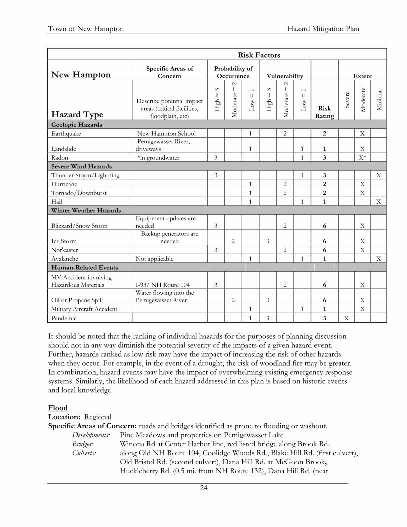
communications within the community, mutual aid resources regionally, public awareness and education, and emergency response training. B. PROFILING HAZARD EVENTS Identification of hazards potentially important to New Hampton was based on local knowledge of department heads and town management, internet research, and through conversation with the New Hampshire Homeland Security and Emergency Management and other agencies. A matrix was created to determine an overall hazard risk assessment rating. Each criterion (probability of occurrence and vulnerability) was given a rating of severe, moderate, or minimal to show which hazards are the greatest threat to the community, based on indicators: danger/destruction, economic, environmental, social, and political planning level. These ratings were then transformed into numerical values 3, 2, and 1, respectively. The overall risk rating associated with each hazard was determined by multiplying the two factors. This resulted in risk ratings ranging from 1 to 9; 1-3 = minimal risk, 4-6 = moderate risk, 7-9 = severe risk. This Plan will focus on those events that pose at least a moderate risk to the town of New Hampton as determined by the Committee (Table X). The entire Risk Assessment Matrix can be found in Appendix G. The extent (i.e. magnitude or severity) has been determined through research and past events in New Hampton, and the potential degree of damage that could occur. Extent was based on potential assistance needed, as defined below:
Minimal: local residents can handle the hazard event without help from outside sources Moderate: county or regional assistance is needed to survive and/or recover Severe: state or federal assistance is necessary to survive and/or recover
Table X: Town of New Hampton Risk Assessment Risk Factors
New Hampton Specific Areas of
Concern Probability of Occurrence Vulnerability Extent
Hazard Type
Describe potential impact areas (critical facilities,
floodplain, etc)
Hig
h =
3
Mod
erat
e =
2
Low
= 1
Hig
h =
3
Mod
erat
e =
2
Low
= 1
Risk Rating
Seve
re
Mod
erat
e
Min
imal
Flood, Drought, Extreme Heat & Wildfire
Flood *Past assistance has involved federal funds 3 2 6 X* X
Dam Failure
Probability – Ayers Island: Low, smaller dams: High 2 2 4 X
Ice Jam
Scouring of NH Rte 104 bridge, Jellystone Campground 1 1 1 X
Drought Would affect the Village Precinct water supply 1 3 3 X
Conflagration Jellystone Campground 1 1 1 X Extreme Heat 1 2 2 X Wildfire Few fires over 5 acres 2 2 4 X
Town of New Hampton Hazard Mitigation Plan
24
Risk Factors
New Hampton Specific Areas of
Concern Probability of Occurrence Vulnerability Extent
Hazard Type
Describe potential impact areas (critical facilities,
floodplain, etc)
Hig
h =
3
Mod
erat
e =
2
Low
= 1
Hig
h =
3
Mod
erat
e =
2
Low
= 1
Risk Rating
Seve
re
Mod
erat
e
Min
imal
Geologic Hazards Earthquake New Hampton School 1 2 2 X
Landslide Pemigewasset River, driveways 1 1 1 X
Radon *in groundwater 3 1 3 X* Severe Wind Hazards Thunder Storm/Lightning 3 1 3 X Hurricane 1 2 2 X Tornado/Downburst 1 2 2 X Hail 1 1 1 X Winter Weather Hazards
Blizzard/Snow Storm Equipment updates are needed 3 2 6 X
Ice Storm Backup generators are
needed 2 3 6 X Nor'easter 3 2 6 X Avalanche Not applicable 1 1 1 X Human-Related Events
MV Accident involving Hazardous Materials I-93/ NH Route 104 3 2 6 X
Oil or Propane Spill Water flowing into the Pemigewasset River 2 3 6 X
Military Aircraft Accident 1 1 1 X Pandemic 1 3 3 X
It should be noted that the ranking of individual hazards for the purposes of planning discussion should not in any way diminish the potential severity of the impacts of a given hazard event. Further, hazards ranked as low risk may have the impact of increasing the risk of other hazards when they occur. For example, in the event of a drought, the risk of woodland fire may be greater. In combination, hazard events may have the impact of overwhelming existing emergency response systems. Similarly, the likelihood of each hazard addressed in this plan is based on historic events and local knowledge. Flood Location: Regional Specific Areas of Concern: roads and bridges identified as prone to flooding or washout. Developments: Pine Meadows and properties on Pemigewasset Lake Bridges: Winona Rd at Center Harbor line, red listed bridge along Brook Rd. Culverts: along Old NH Route 104, Coolidge Woods Rd., Blake Hill Rd. (first culvert), Old Bristol Rd. (second culvert), Dana Hill Rd. at McGoon Brook, Huckleberry Rd. (0.5 mi. from NH Route 132), Dana Hill Rd. (near

Town of New Hampton Hazard Mitigation Plan
25
Lower Oxbow Rd.), Sky Pond Rd., Straits Rd. (3 – near Forest Pond Rd., 1.5 mi. west of Evergreen Dr., and 0.5 mi. east of Dana Hill Rd.) Catch Basins: Shingle Camp Hill Rd. (Phase I has begun) Beaver Activity: Harper’s Brook (impacts Pemi Lake and Old NH Route 104), Carter Mtn. Rd. (could impact Brook Rd.) Critical Facilities: Essential Services, Dams, Evacuation Routes Probability of Occurrence: High Vulnerability: Moderate Overall Risk: Moderate Extent: Moderate to Severe In early August of 2008 fourteen northern New Hampton roads suffered moderate damage and Winona and Winona Roads experienced severe washouts as the result of a brief, intense, isolated storm. The Road Agent pointed out that similar damage could have occurred in the southern portion of town, had the storm been focused there. The associated costs of culvert flooding and washouts are readily calculated based on materials, labor and equipment expenses used by DPW. Development causes greater potential for culvert and road washouts. It can also increase the potential for flooding on neighboring properties if stormwater is not properly designed and incorporated on-site. Impeded stream flows and steep slope degradation can also contribute to stormwater flooding. The New Hampton Site Plan Regulations currently limits development on slopes greater than 20 percent. New Hampton participates in the FEMA National Flood Insurance Program (NFIP), enabling residents to purchase flood insurance policies. Currently, twelve policies are in force covering $1.6 million worth of insurance. Since 1976, five claims have been paid by FEMA for flood related damage in New Hampton, totaling $64,752 (not including August 2008 flooding). Dam Failure Location: State-wide Specific Areas of Concern: Dickerman Pond dam above NH Route 132, Critical Facilities: NH Route 132 Probability of Occurrence: Moderate Vulnerability: Moderate Overall Risk: Moderate Extent: Severe New Hampton has twenty-one active dams listed with NH DES; fourteen are rated AA, four are rated as Class B, and the three of the Fish Hatchery dams are exempt from a Hazard Class rating. The 90-foot Class C Ayers
Dickerman Dam
Winona Road, August, 2008

Town of New Hampton Hazard Mitigation Plan
26
Island dam controls the Pemigewasset River between New Hampton and Bristol. The Committee felt that the greatest concern was from the numerous small dams and their compounding effect if one or more of these were breached. Wildfire Location: Town-wide Specific Areas of Concern: Areas with steep slopes and limited access Critical Facilities: None Probability of Occurrence: Moderate Vulnerability: Moderate Overall Risk: Moderate Extent: Severe Much of New Hampton is wooded. The Committee noted that despite having limited water resources in the southern section of town, few fires ever get to be five acres in size. Accessibility to many parts of town is limited due to steep slopes, making it quite difficult to surround fires. Blizzard/Snowstorm Location: Regional Specific Areas of Concern: Elderly, those with limited egress Critical Facilities: Essential Services, Shelters, DPW Probability of Occurrence: High Vulnerability: Moderate Overall Risk: Moderate Extent: Moderate A heavy snowfall places additional pressures on the Public Works Department to keep local roads clear and safe for not only local traffic but especially for emergency services. If the town did need to open shelter facilities, additional pressure would be placed upon these facilities. The resources for maintaining the town’s roads are limited. Of great concern is the possibility of roofs collapsing under the weight of snow. Ice Storm Location: Regional Specific Areas of Concern: Higher elevation homes Critical Facilities: Essential Services, Shelters, DPW Probability of Occurrence: Moderate Vulnerability: High Overall Risk: Moderate Extent: Moderate The Ice Storm of 1998 brought down many trees in New Hampton, some on wires and across roads. The same facilities and services are impacted in an ice storm as in a blizzard/snowstorm, however, the likelihood of blocked roads, loss of power, and limited travel is greater, especially at higher elevations. In an ice storm one of the biggest concerns is downed lines, resulting in the loss of power; this is especially important in New Hampton since the only back up generation for public benefit is at the DPW and limited sections of New Hampton School.

Town of New Hampton Hazard Mitigation Plan
27
Nor’easter Location: State-wide Specific Areas of Concern: Critical Facilities: Essential Services, Shelters, DPW Probability of Occurrence: High Vulnerability: Moderate Overall Risk: Moderate Extent: Moderate Because of their long duration and large amounts of precipitation of all sorts, nor’easters put additional pressure on all municipal facilities and services. In communities such as New Hampton, emergency services and snow removal staff end up working round the clock and large quantities of snow and ice can collapse roofs. Motor Vehicle Accident involving Hazardous Materials Location: Localized Specific Areas of Concern: water bodies, I-93 and NH Route 104 Critical Facilities: Essential Services, Evacuation Routes, Fuel Stations Probability of Occurrence: High Vulnerability: Moderate Overall Risk: Moderate Extent: Moderate The costs associated with cleaning up a hazardous spill can vary greatly depending upon the substance, its quantity, and the resources threatened. Interstate 93 and NH Route 132 run north-south through the center of New Hampton and along its northwestern boundary. They also run adjacent to the Pemigewasset River. NH Route 104 runs east-west through the commercial section of town passing Pemigewasset Lake and over the Pemigewasset River. There is concern by the Committee that the effects of a hazardous material spill along either of these routes could impact not only the flow of traffic along these busy corridors, but also lead to safety and pollution problems. The junction of I-93 and NH Route 104 is of particular concern because these are heavily traveled roadways and the traffic pattern at this location can be challenging. These are also the two major evacuation routes in town. Oil or Propane Spill Location: Localized Specific Areas of Concern: water bodies, intersections, roads/evacuation routes, water supplies Critical Facilities: Essential Services Probability of Occurrence: Moderate Vulnerability: High Overall Risk: Moderate Extent: Moderate Most oil tankers have the capacity to carry 1,000 gallons of home heating oil. The trucks travel throughout New Hampton and the area daily to fulfill their deliveries. Interstate 93, NH Routes 104 and 132 are state roads running through New Hampton, carrying vehicles of all types, including oil tankers.

Town of New Hampton Hazard Mitigation Plan
28
The town of New Hampton Fire Department does not have booms for containment of a spill into the water. A spill in the Village area could very quickly get into Dickerman Brook and the Pemigewasset River. The state’s spill response team should be alerted immediately if a spill occurs near a water body, regardless of the size. Costs associated with spill containment and clean up involving water resources are certain to be high. C. HISTORICAL HAZARD EVENTS On January 7 and 8, 1998, a devastating ice storm hit and mainly affected upstate New York, northern New Hampshire and Vermont, much of Maine, and southeast Canada. Some locations received over 3 inches of rain (as freezing rain), with radial ice thickness of one inch or more. New England reported over 500,000 customers without power and overall damages approached $3 billion for Canada and were at least $1.4 billion for the U.S. In New Hampshire, 140,000 people lost electricity, some for as long as eight days, 38 shelters were set up that served 700 refugees, and two storm related deaths were reported. More recently and locally, the August 4, 2008 rains caused substantial flash flooding and washouts in New Hampton, Center Harbor, Meredith, and Ashland. In addition to property damages, one death was recorded as a result of this storm. NH HSEM is working on a Disaster Declaration for municipalities. Table XI details historic events that have impacted the town of New Hampton within the last eighty years. NOAA reports 107 snow and Ice Storms impacting Belknap County between 1993 and 2007 and 124 thunderstorm/wind events from 1960 through 2007. The following hazards have yet to occur in New Hampton or historic records were unavailable: motor vehicle accident involving hazardous materials, oil/propane spill, extreme heat, and radon. Table XI: Past Hazard Events in the Region Hazard Date Location Description Source Dam Failure 2005 Harper's Brook
Dam - Pit Rd. Dam had a hole on it, required repair NH
HMPC Drought 6/1/1999 Statewide Governor's Office declaration moderate drought
for most of the state. FEMA
Drought 1929-1936 Statewide Regional FEMA Drought 1939-1944 Statewide Severe in Southeast FEMA Drought 1947-1950 Statewide Moderate FEMA Drought 1960-1969 Statewide Longest record continuous period of below normal
precipitation. FEMA
Drought 2004 New Hampton The Village Precinct water supply and several wells, including the elementary school were quite low.
NH HMPC
Earthquake 12/20/1940 Carroll County 5.5 on Richter scale - affected region NH HSEM
Earthquake 12/24/1940 Carroll County 5.5 on Richter scale - affected region NH HSEM
Earthquake 1/18/1982 Sanbornton, NH 4.5 Richter Scale - felt in Nashua NOAA
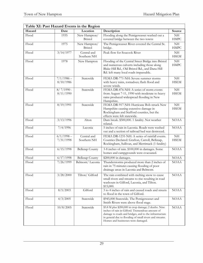
Town of New Hampton Hazard Mitigation Plan
29
Table XI: Past Hazard Events in the Region Hazard Date Location Description Source Flood 1935 New Hampton/
Bristol Flooding along the Pemigewasset washed out a covered bridge between the two towns
NH HMPC
Flood 1975 New Hampton/ Bristol
The Pemigewasset River covered the Central St. bridge.
NH HMPC
Flood 3/14/1977 Central and Southern NH
Peak flow for Soucook River NH HSEM
Flood 1978 New Hampton Flooding of the Central Street Bridge into Bristol and numerous culverts including those along Blake Hill Rd., Old Bristol Rd., and Dana Hill Rd. left many local roads impassable.
NH HMPC
Flood 7/1/1986 – 8/10/1986
Statewide FEMA DR-771-NH: Severe summer storms with heavy rains, tornadoes; flash flood and severe winds.
NH HSEM
Flood 8/ 7/1990 - 8/11/1990
Statewide FEMA DR-876-NH: A series of storm events from August 7-11, 1990 with moderate to heavy rains produced widespread flooding in New Hampshire.
NH HSEM
Flood 8/19/1991 Statewide FEMA DR-917-NH: Hurricane Bob struck New Hampshire causing extensive damage in Rockingham and Stafford counties, but the effects were felt statewide.
NH HSEM
Flood 3/13/1996 Alton Dam break. $500,000. 1 fatality. Not weather related.
NOAA
Flood 7/4/1996 Laconia 5 inches of rain in Laconia. Roads were washed out and a section of railroad bed was destroyed.
NOAA
Flood 6/1/1998 – 7/31/1998
Central and Southern NH
FEMA DR-1231-NH: A series of rainfall events. Counties Declared: Grafton, Carroll, Belknap, Rockingham, Sullivan, and Merrimack (1 fatality)
NH HSEM
Flood 6/15/1998 Belknap County 3-8 inches of rain. $100,000 in damages. Some homes and campgrounds were evacuated.
NOAA
Flood 6/17/1998 Belknap County $200,000 in damages. NOAA Flood 7/26/1999 Belmont/ Laconia Thunderstorms produced more than 2 inches of
rain in 75 minutes causing flooding of poor drainage areas in Laconia and Belmont.
NOAA
Flood 3/28/2000 Tilton/ Gilford The rain combined with melting snow to cause small rivers and streams to rise resulting in road washouts in Gilford, Laconia, and Tilton. $15,000.
NOAA
Flood 8/5/2003 Gilford 3 to 4 inches of rain and caused roads and streets to flood in the town of Gilford.
NOAA
Flood 4/3/2005 Statewide $945,000 Statewide. The Pemigewasset and Smith Rivers were above flood stage.
NOAA
Flood 10/8/2005 Statewide $5.8 M plus $200,000 in crop damage; 2 deaths. Nine inches of rain in Gilford. Tremendous amount of damage to roads and bridges, and to the infrastructure in general due to flooding of small rivers and streams. Homes and businesses were damaged.
NOAA
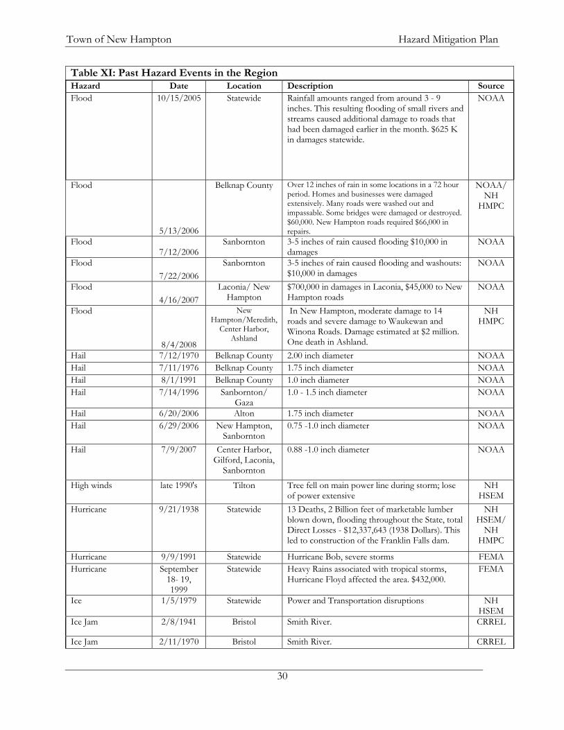
Town of New Hampton Hazard Mitigation Plan
30
Table XI: Past Hazard Events in the Region Hazard Date Location Description Source Flood 10/15/2005 Statewide Rainfall amounts ranged from around 3 - 9
inches. This resulting flooding of small rivers and streams caused additional damage to roads that had been damaged earlier in the month. $625 K in damages statewide.
NOAA
Flood
5/13/2006
Belknap County Over 12 inches of rain in some locations in a 72 hour period. Homes and businesses were damaged extensively. Many roads were washed out and impassable. Some bridges were damaged or destroyed. $60,000. New Hampton roads required $66,000 in repairs.
NOAA/ NH
HMPC
Flood 7/12/2006
Sanbornton 3-5 inches of rain caused flooding $10,000 in damages
NOAA
Flood 7/22/2006
Sanbornton 3-5 inches of rain caused flooding and washouts: $10,000 in damages
NOAA
Flood 4/16/2007
Laconia/ New Hampton
$700,000 in damages in Laconia, $45,000 to New Hampton roads
NOAA
Flood
8/4/2008
New Hampton/Meredith,
Center Harbor, Ashland
In New Hampton, moderate damage to 14 roads and severe damage to Waukewan and Winona Roads. Damage estimated at $2 million. One death in Ashland.
NH HMPC
Hail 7/12/1970 Belknap County 2.00 inch diameter NOAA Hail 7/11/1976 Belknap County 1.75 inch diameter NOAA Hail 8/1/1991 Belknap County 1.0 inch diameter NOAA Hail 7/14/1996 Sanbornton/
Gaza 1.0 - 1.5 inch diameter NOAA
Hail 6/20/2006 Alton 1.75 inch diameter NOAA Hail 6/29/2006 New Hampton,
Sanbornton 0.75 -1.0 inch diameter NOAA
Hail 7/9/2007 Center Harbor, Gilford, Laconia,
Sanbornton
0.88 -1.0 inch diameter NOAA
High winds late 1990's Tilton Tree fell on main power line during storm; lose of power extensive
NH HSEM
Hurricane 9/21/1938 Statewide 13 Deaths, 2 Billion feet of marketable lumber blown down, flooding throughout the State, total Direct Losses - $12,337,643 (1938 Dollars). This led to construction of the Franklin Falls dam.
NH HSEM/
NH HMPC
Hurricane 9/9/1991 Statewide Hurricane Bob, severe storms FEMA Hurricane September
18- 19, 1999
Statewide Heavy Rains associated with tropical storms, Hurricane Floyd affected the area. $432,000.
FEMA
Ice 1/5/1979 Statewide Power and Transportation disruptions NH HSEM
Ice Jam 2/8/1941 Bristol Smith River. CRREL
Ice Jam 2/11/1970 Bristol Smith River. CRREL
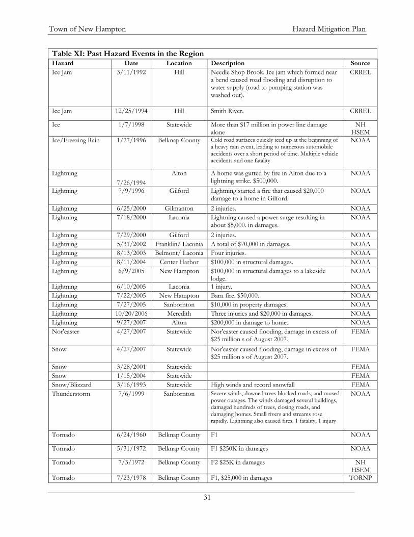
Town of New Hampton Hazard Mitigation Plan
31
Table XI: Past Hazard Events in the Region Hazard Date Location Description Source Ice Jam 3/11/1992 Hill Needle Shop Brook. Ice jam which formed near
a bend caused road flooding and disruption to water supply (road to pumping station was washed out).
CRREL
Ice Jam 12/25/1994 Hill Smith River. CRREL
Ice 1/7/1998 Statewide More than $17 million in power line damage alone
NH HSEM
Ice/Freezing Rain 1/27/1996 Belknap County Cold road surfaces quickly iced up at the beginning of a heavy rain event, leading to numerous automobile accidents over a short period of time. Multiple vehicle accidents and one fatality
NOAA
Lightning 7/26/1994
Alton A home was gutted by fire in Alton due to a lightning strike. $500,000.
NOAA
Lightning 7/9/1996 Gilford Lightning started a fire that caused $20,000 damage to a home in Gilford.
NOAA
Lightning 6/25/2000 Gilmanton 2 injuries. NOAA Lightning 7/18/2000 Laconia Lightning caused a power surge resulting in
about $5,000. in damages. NOAA
Lightning 7/29/2000 Gilford 2 injuries. NOAA Lightning 5/31/2002 Franklin/ Laconia A total of $70,000 in damages. NOAA Lightning 8/13/2003 Belmont/ Laconia Four injuries. NOAA Lightning 8/11/2004 Center Harbor $100,000 in structural damages. NOAA Lightning 6/9/2005 New Hampton $100,000 in structural damages to a lakeside
lodge. NOAA
Lightning 6/10/2005 Laconia 1 injury. NOAA Lightning 7/22/2005 New Hampton Barn fire. $50,000. NOAA Lightning 7/27/2005 Sanbornton $10,000 in property damages. NOAA Lightning 10/20/2006 Meredith Three injuries and $20,000 in damages. NOAA Lightning 9/27/2007 Alton $200,000 in damage to home. NOAA Nor'easter 4/27/2007 Statewide Nor'easter caused flooding, damage in excess of
$25 million s of August 2007. FEMA
Snow 4/27/2007 Statewide Nor'easter caused flooding, damage in excess of $25 million s of August 2007.
FEMA
Snow 3/28/2001 Statewide FEMA Snow 1/15/2004 Statewide FEMA Snow/Blizzard 3/16/1993 Statewide High winds and record snowfall FEMA Thunderstorm 7/6/1999 Sanbornton Severe winds, downed trees blocked roads, and caused
power outages. The winds damaged several buildings, damaged hundreds of trees, closing roads, and damaging homes. Small rivers and streams rose rapidly. Lightning also caused fires. 1 fatality, 1 injury
NOAA
Tornado 6/24/1960 Belknap County F1 NOAA
Tornado 5/31/1972 Belknap County F1 $250K in damages NOAA
Tornado 7/3/1972 Belknap County F2 $25K in damages NH HSEM
Tornado 7/23/1978 Belknap County F1, $25,000 in damages TORNP

Town of New Hampton Hazard Mitigation Plan
32
Table XI: Past Hazard Events in the Region Hazard Date Location Description Source Tornado 7/23/1995 Meredith F1 NH
HSEM Tornado 7/6/1999 Belknap County F1 NH
HSEM Tornado 7/24/2008 Five counties,
including Belknap, Merrimack, and
Carroll
50-mile swath cut through south-central part of NH. Nineteen homes destroyed. One death. State and federal disaster declared in five counties.
NH HSEM
Multiple Occurrences
Earthquakes 1990 - 2008 Region 13 in Belknap Co., 10 around Franklin, and four other s in Lakes Region. Magnitudes range from 1.7 - 3.0.
NESN
Flooding regularly Pine Meadows development
Due to poor drainage, these homes are flooded regularly; sandbagging was required in 2007.
NH HMPC
Flooding regularly Pemi Shores Regularly floods due to a beaver dam and the need for a larger culvert along Old NH Rte 104.
NH HMPC
Flooding regularly Winona Rd. Bridge at Center
Harbor TL
The road and bridge are low. NH HMPC
Flooding Several times per
year
Blake Hill Rd., Straits Rd. near Dana Hill Rd.
Due to small culvert diameter, this floods frequently
NH HMPC
Snow and ice storms 1993 - 2007 Belknap County 107 storms reported, resulting in a total of $27.27M in reported damages and three injuries.
NOAA
Thunderstorms 1960 - 2007 Belknap County 124 storms reported, resulting in a total of $1.287M in reported damages, thirteen injuries, and two deaths.
NOAA
Table Sources: FEMA = Federal Emergency Management Agency NESN = New England Seismic Network http://quake.bc.edu:8000/cgi-bin/NESN/print_catalog.pl NESEC = Northeast States Emergency Consortium NH HMPC = New Hampton Hazard Mitigation Plan Committee NHHSEM = New Hampshire Homeland Security and Emergency Management NIFC = National Interagency Fire Center NTSB = National transportation Safety Board NOAA = National Oceanic and Atmospheric Admin. TORNP = The Tornado Project http://www4.ncdc.noaa.gov/cgi-win/wwcgi.dll?wwEvent~Storms

Town of New Hampton Hazard Mitigation Plan
33
CHAPTER IV: VULNERABILITY ASSESSMENT A. CLASSIFICATION OF CRITICAL INFRASTRUCTURE The list of critical infrastructure for the town of New Hampton was identified by the Committee. The critical infrastructure list can be broken into five categories, 1) Essential Services; 2) Emergency Shelters; 3) Structures and Services; 4) Special Populations; 5) Other. The first category contains facilities essential in a hazard event. The second category is a list of the pre-defined emergency shelters within the community. The third category contains non-essential facilities that have been identified by the Committee as services and facilities to protect. The fourth category contains populations that the Committee wished to protect in the event of a disaster. The fifth category contains other infrastructure that was important to the Committee. The Critical Facilities and Potential Hazards Map is located in Appendix D. Essential Services: Facility: Fire Department Location: Firehouse Lane Facility: New Hampton Town Offices Location: 6 Pinnacle Hill Rd. Facility: Police Department Location: 6 Pinnacle Hill Rd. Facility: New Hampton DPW Garage Location: 26 NH Route 132 Facility: NH DOT Garage Location: State DOT Dr.
New Hampton Fire Department
New Hampton Town Offices and Police Station
New Hampton Transfer Station and Department of Public Works Garage

Town of New Hampton Hazard Mitigation Plan
34
Facility: Village Precinct Water Facility Location: Gordon Hill Rd Facility: Village Precinct Sewage Treatment Facility Location: Mill Lane Facility: Village Precinct Electrical Substation Location: Behind Fire Station on Firehouse Lane Facility: Cistern Location: Fairway/ Pine Rd. Emergency Shelters: Facility: New Hampton School Location: Main Street Facility: New Hampton Community School Location: 191 Main St. Special Populations: Facility: New Hampton Community School Location: 191 Main St. New Hampton School Location: Main Street Structures and Services: Facility: Town House Location: Meetinghouse Lane Other: Facility: New Hampton Transfer Station – Hazardous Materials Location: 26 NH Route 132 Facility: New Hampton School Ice Hockey Rink – Hazardous Materials Location: Dr. Childs Road B. NATURAL HAZARDS VULNERABILITY OF CRITICAL FACILITIES The Critical Facilities and Potential Hazards Map (Appendix D) identifies the location of critical facilities in relation to mapped hazard areas. No essential service critical facilities are located within the flooding hazard area. The Critical Facilities Natural Hazards Vulnerability Assessment, Appendix F, ranks each moderate to high risk hazard discussed in Chapter III for each critical facility. They are ranked low to high, based on the potential economic, environmental and social impacts, and level of danger/damage to buildings, infrastructure and services of the hazard to the facility. The Community School and Fire Department were identified as the facilities most impacted by natural hazards. The Transfer Station, Gordon Nash Library, and cistern were viewed as the least vulnerable facilities.
New Hampton School
New Hampton Community School
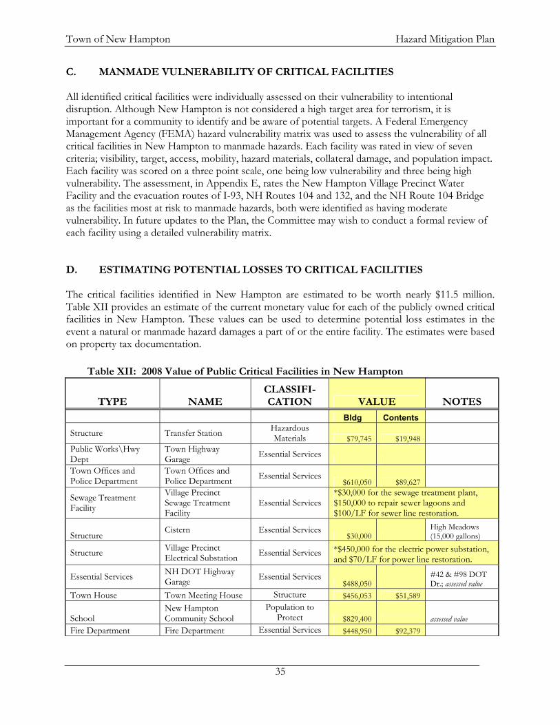
Town of New Hampton Hazard Mitigation Plan
35
C. MANMADE VULNERABILITY OF CRITICAL FACILITIES All identified critical facilities were individually assessed on their vulnerability to intentional disruption. Although New Hampton is not considered a high target area for terrorism, it is important for a community to identify and be aware of potential targets. A Federal Emergency Management Agency (FEMA) hazard vulnerability matrix was used to assess the vulnerability of all critical facilities in New Hampton to manmade hazards. Each facility was rated in view of seven criteria; visibility, target, access, mobility, hazard materials, collateral damage, and population impact. Each facility was scored on a three point scale, one being low vulnerability and three being high vulnerability. The assessment, in Appendix E, rates the New Hampton Village Precinct Water Facility and the evacuation routes of I-93, NH Routes 104 and 132, and the NH Route 104 Bridge as the facilities most at risk to manmade hazards, both were identified as having moderate vulnerability. In future updates to the Plan, the Committee may wish to conduct a formal review of each facility using a detailed vulnerability matrix. D. ESTIMATING POTENTIAL LOSSES TO CRITICAL FACILITIES The critical facilities identified in New Hampton are estimated to be worth nearly $11.5 million. Table XII provides an estimate of the current monetary value for each of the publicly owned critical facilities in New Hampton. These values can be used to determine potential loss estimates in the event a natural or manmade hazard damages a part of or the entire facility. The estimates were based on property tax documentation.
Table XII: 2008 Value of Public Critical Facilities in New Hampton
TYPE NAME CLASSIFI-CATION VALUE NOTES
Bldg Contents
Structure Transfer Station Hazardous Materials $79,745 $19,948
Public Works\Hwy Dept
Town Highway Garage Essential Services
Town Offices and Police Department
Town Offices and Police Department Essential Services
$610,050 $89,627
Sewage Treatment Facility
Village Precinct Sewage Treatment Facility
Essential Services *$30,000 for the sewage treatment plant, $150,000 to repair sewer lagoons and $100/LF for sewer line restoration.
Structure Cistern Essential Services $30,000
High Meadows (15,000 gallons)
Structure Village Precinct Electrical Substation Essential Services *$450,000 for the electric power substation,
and $70/LF for power line restoration.
Essential Services NH DOT Highway Garage Essential Services
$488,050 #42 & #98 DOT Dr.; assessed value
Town House Town Meeting House Structure $456,053 $51,589
School New Hampton Community School
Population to Protect $829,400 assessed value
Fire Department Fire Department Essential Services $448,950 $92,379
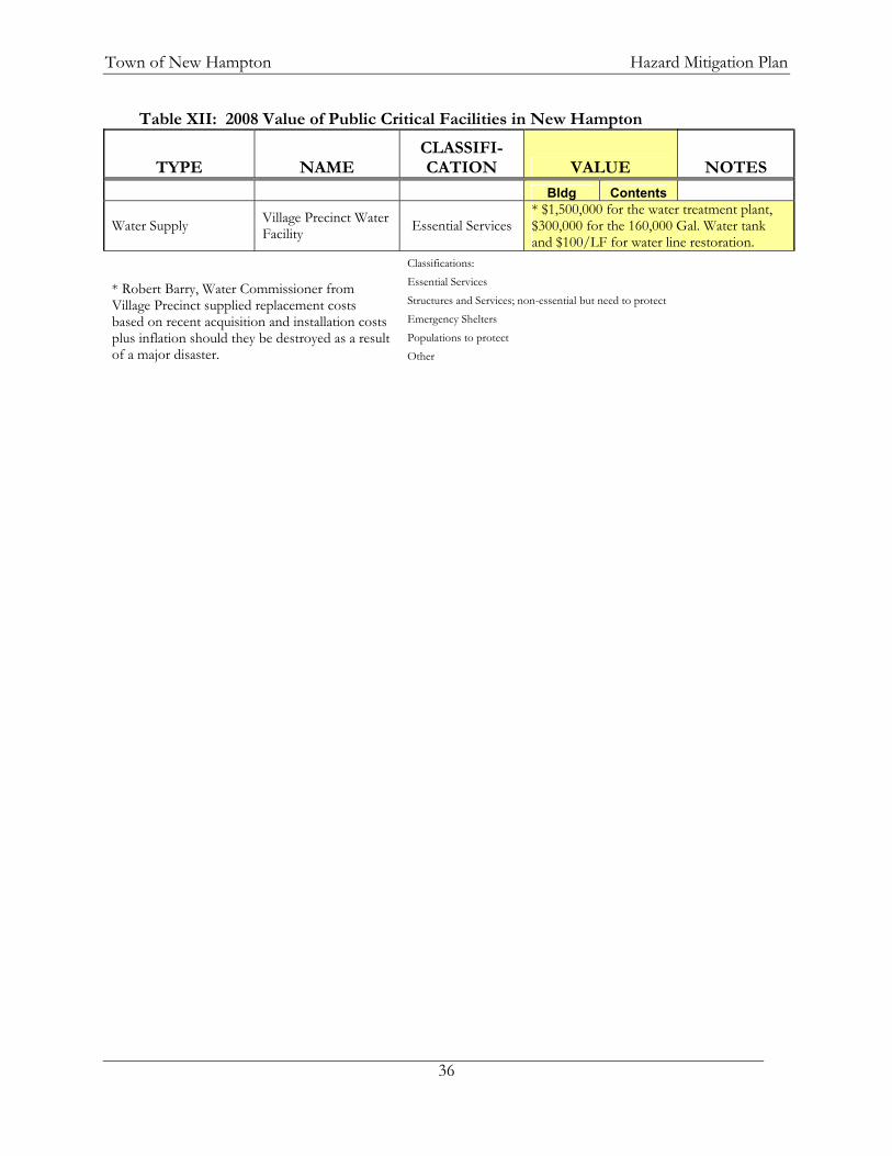
Town of New Hampton Hazard Mitigation Plan
36
Table XII: 2008 Value of Public Critical Facilities in New Hampton
TYPE NAME CLASSIFI-CATION VALUE NOTES
Bldg Contents
Water Supply Village Precinct Water Facility Essential Services
* $1,500,000 for the water treatment plant, $300,000 for the 160,000 Gal. Water tank and $100/LF for water line restoration.
Classifications: Essential Services Structures and Services; non-essential but need to protect Emergency Shelters Populations to protect
* Robert Barry, Water Commissioner from Village Precinct supplied replacement costs based on recent acquisition and installation costs plus inflation should they be destroyed as a result of a major disaster. Other

Town of New Hampton Hazard Mitigation Plan
37
CHAPTER V: MITIGATION STRATEGIES A. STATE OF NEW HAMPSHIRE HAZARD MITIGATION GOALS39 The State of New Hampshire Natural Hazard Mitigation Plan prepared and maintained by the New Hampshire Homeland Security and Emergency Management (NH HSEM), sets forth the following overall hazard mitigation goals for the State of New Hampshire:
I. To improve upon the protection of the general population, the citizens of the State and guests, from all natural and man-made hazards.
II. To reduce the potential impact of natural and man-made disasters on the State’s Critical Support Services.
III. To reduce the potential impact of natural and man-made disasters on Critical Facilities in the State.
IV. To reduce the potential impact of natural and man-made disasters on the State’s infrastructure.
V. To improve Emergency Preparedness.
VI. Improve the State’s Disaster Response and Recovery Capability.
VII. To reduce the potential impact of natural and man-made disasters on private property.
VIII. To reduce the potential impact of natural and man-made disasters on the State’s economy.
IX. To reduce the potential impact of natural and man-made disasters on the State’s natural environment.
X. To reduce the State’s liability with respect to natural and man-made hazards generally.
XI. To reduce the potential impact of natural and man-made disasters on the State’s specific historic treasures and interests as well as other tangible and intangible characteristics which add to the quality of life of the citizens and guests of the State.
XII. To identify, introduce and implement cost effective Hazard Mitigation measures so as to accomplish the State’s Goals and Objectives and to raise the awareness of, and acceptance of Hazard Mitigation generally.
39 NH Homeland Security and Emergency Management website. http://www.nhoem.state.nh.us/mitigation/, visited March 4, 2008.

Town of New Hampton Hazard Mitigation Plan
38
B. TOWN OF NEW HAMPTON, NEW HAMPSHIRE HAZARD MITIGATION
GOALS The New Hampton Hazard Mitigation Planning Committee concurs with the State Hazard Mitigation goals and further defined goals most pertinent to the town. Based on the hazards studied, and the assessment of current and proposed mitigation strategies, the Committee recommends the following hazard mitigation goals for the town of New Hampton: Goal I: Community and Resource Protection Reduce the potential impact of natural and manmade disasters on the town’s residents and visitors, as well as its critical facilities, property, economy, and natural resources, while improving the emergency communication, alert, and response systems. Goal II: Outreach and Education Improve public awareness of the impacts of potential hazards and hazard preparedness, while increasing the public’s involvement in emergency response and recovery. Goal III: Coordination and Communication Ensure plans are in place to address various emergency situations and that regular communication occurs between various departments and with local, regional, and state officials; thereby ensuring that those involved are aware of their responsibilities.
Goal IV: Damage Prevention Minimize the damage and public expense which might be caused to public and private buildings and infrastructure due to natural and manmade hazards.

Town of New Hampton Hazard Mitigation Plan
39
C. EXISTING MITIGATION STRATEGIES A review of existing mitigation strategies was conducted. The assessment included review of pertinent documents including the zoning ordinance, subdivision regulations, emergency management plan, site plan regulations, annual report, and discussion with Committee members. Table XIII details the mitigation strategies that currently exist or are in the process of being developed for the town of New Hampton. Table XIII: Existing Mitigation Strategies
Existing Protection
Description Area Covered Enforcement
Zoning Ordinance (2008)
Flood Hazard District Flood Hazard Boundary Map, 1986 Pemi and Waukewan Overlay
Districts Setbacks refer to buffers Do have maximum lot coverage
(reducing runoff)
Town Selectmen
Subdivision Regulations (2008)
General Guidelines – slope, fire, flood, premature development
Subdivisions of 50 lots or 5 acres, flood elevation data required
Extension of utilities may be required. Stormwater management required. New roads to town standards Slopes >25% are considered
unbuildable Specific statements in Appendix B:
Criteria for Determining Regional Impact regarding “accidents that would require evacuation of a large area” and “the generation and/or use of any hazardous materials”.
No dead-end streets over 1,500’, encouragement of intersecting streets.
Limit on road intersections near steep grades.
Driveway regulations Private road standards Soils-based lot sizing
Town Selectmen

Town of New Hampton Hazard Mitigation Plan
40
Existing Protection
Description Area Covered Enforcement
Site Plan Regulations (2008)
Require review by Fire Chief, Police Chief, Public Works Director, and Conservation Commission.
Fire Chief inspection of site is required, implementing National Fire Prevention Association standards.
Require Stormwater Management and Erosion Control on lots with specific characteristics.
Specific statements in Appendix B: Criteria for Determining Regional Impact regarding “accidents that would require evacuation of a large area” and “the generation and/or use of any hazardous materials”.
Town Selectmen
Sewer/Water Service
Village Precinct has 100,000 gallon capacity
Village Precinct Village Precinct Board of Commissioners
Radio Communications
Through Lakes Region Dispatch
Emergency Management Director (EMD)
Fire Department/
Fire Chief is part-time 4 Deputy Fire Wardens About 35 volunteer firefighters Lakes Region Mutual Aid Maintenance & Replacement schedule Have forestry equipment
Town/Region Fire Chief
Police Department
Police Chief is full-time Six full time and 2 part-time staff plus
one Administrative Assistant. Do have a Maintenance/Replacement
schedule. Get assistance from Belknap County
Sheriff’s office. Participate in Lakes Region Mutual
Aid
Town Police Chief
Ambulance Through the Fire Department Town Selectmen
Department of Public Works
Road Agent/Director is full-time Five full-time staff, one part-time
staff. Transfer station is staffed by the
DPW. Have separate capital reserve funds
for bridges, buildings, and equipment.
Town Director of DPW
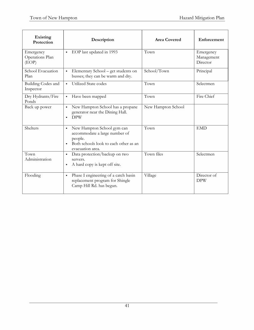
Town of New Hampton Hazard Mitigation Plan
41
Existing Protection
Description Area Covered Enforcement
Emergency Operations Plan (EOP)
EOP last updated in 1993 Town Emergency Management Director
School Evacuation Plan
Elementary School – get students on busses; they can be warm and dry.
School/Town Principal
Building Codes and Inspector
Utilized State codes Town Selectmen
Dry Hydrants/Fire Ponds
Have been mapped Town Fire Chief
Back up power New Hampton School has a propane generator near the Dining Hall.
DPW
New Hampton School
Shelters New Hampton School gym can accommodate a large number of people.
Both schools look to each other as an evacuation area.
Town EMD
Town Administration
Data protection/backup on two servers.
A hard copy is kept off site.
Town files Selectmen
Flooding Phase I engineering of a catch basin replacement program for Shingle Camp Hill Rd. has begun.
Village Director of DPW

Town of New Hampton Hazard Mitigation Plan
42
D. GAPS IN EXISTING MITIGATION STRATEGIES During the review of pertinent documents, the Committee identified gaps in the existing strategies. Identifying these gaps fostered the brainstorming sessions that generated the ultimate list of mitigation actions. Some actions address multiple gaps. Table XIV details the gaps, identified by the Committee, that currently exist for the town of New Hampton. Table XIV: Gaps in Existing Mitigation Strategies
Description of Gap Action No Steep Slopes Ordinance (concern about steep driveways and erosion along driveways)
Develop & implement a Steep Slopes Ordinance as a means of reducing erosion and ensuring that driveways are accessible to emergency vehicles
Long driveways with no turnarounds – difficult for emergency vehicles
Adopt a zoning ordinance regulation requiring driveways to have a turnaround enabling better access with Emergency vehicles.
No residential water/sprinkler systems (fire department is working on this)
Work with North Country Resource Conservation & Development for the development of a town-wide water resources plan for firefighting.
Precinct water supply is surface water and susceptible to disruption or contamination
Develop an underground water supply for the Village Precinct to reduce the likelihood of contamination or disruption.
All town departments except DPW and all shelters are dependent upon the Precinct water supply.
Work with North Country Resource Conservation & Development for the development of a town-wide water resources plan for firefighting.
DPW cannot easily communicate with Police and Fire Departments.
Install and utilize the Emergency Management Frequency.
DPW does not have digital radios Replace DPW's analog radios with digital radios.
State Highway is on its own frequency. Work with New Hampshire DOT to program existing NHDOT frequency into our radios.
Poor reception in both northern and southern portion of town including Jellystone campground.
Work with a consultant to conduct a feasibility study of the Town of New Hampton to identify an area or areas that would be suitable for an antenna for either a repeater or straight transmitter site. To share costs, partner with Lakes Region Mutual Aid and the Belknap County Sheriff Department.
There are not enough telephone lines at Town Office, Police Station, or Fire station to serve as an Emergency Operations Center.
Install a VoIP telephone system that could be utilized in all town-owned buildings with the hub at the Town Office, and the possibility for the vendor to add more lines at a later date. This will enable the Town Offices to serve as the Emergency Operations Center and improve communication throughout town.
Reception with portable radios is poor at New Hampton School.
See Above.

Town of New Hampton Hazard Mitigation Plan
43
Description of Gap Action Inadequate training of town personnel on use of emergency radio channel.
Ensure that all town radios have access to the Emergency Radio Channel and that all town emergency workers are trained in its operation.
Fire equipment capacity is limited by the building size.
Provide more space for storage of Fire equipment.
Fire equipment replacement schedule is quite susceptible to budget cuts.
Adopt and implement a fire equipment update schedule.
Have limited man power in fire department. Research the cost and feasibility for cross-training town employees to augment the Fire Department's manpower needs.
Can only “soft-connect” to hydrants in the Village Precinct – dependent upon a gravity feed.
Work with North Country Resource Conservation & Development for the development of a town-wide water resources plan for firefighting.
Limited HazMat training Train police officers in HazMat response using either the New Hampshire Police Standards and Training Council or New Hampshire Fire Standards and Training.
DPW vehicle fleet is getting older. - Adopt and implement a DPW equipment update schedule. - Develop a Capital Improvements Plan (CIP), enabling the town to more readily plan for the replacement or expansion of large equipment and facilities.
Drainage along numerous roads and in a couple of neighborhoods is inadequate for accommodating the water capacity.
- Increase the diameter of the following culverts: - along Old NH Route 104,. - Blake Hill Rd. (first culvert), - Old Bristol Rd. (second culvert), - Dana Hill Rd. at Magoon Brook, - Dana Hill Rd. (near Lower Oxbow Rd.), - Huckleberry Rd. (0.5 mi. from NH Route 132), - Sky Pond Rd., - Straits Rd. (near Forest Pond Rd.) - Straits Rd. (0.5 mi. east of Dana Hill Rd.)
- Extend the 4’ culvert on Coolidge Woods Rd. (south of Brook Rd.) by eight feet. - Replace the two small culverts in the middle of Straits Rd. with one large diameter culvert. - Complete all phases of the catch basin replacement work along Shingle Camp Hill Rd. - Inventory and maintain a database of culverts and their conditions.
Replacing/upgrading culverts can get bogged down in paperwork.
Work with NH DES to streamline the culvert replacement/ wetlands disturbance application process.
Limited staffing and materials for detouring traffic.
- Create a resource list for the availability of traffic detour equipment and possibly personnel (i.e. C.E.R.T. Teams) from the state and surrounding communities. - Inventory town signage and purchase sufficient signage for detouring traffic in the event of an emergency.
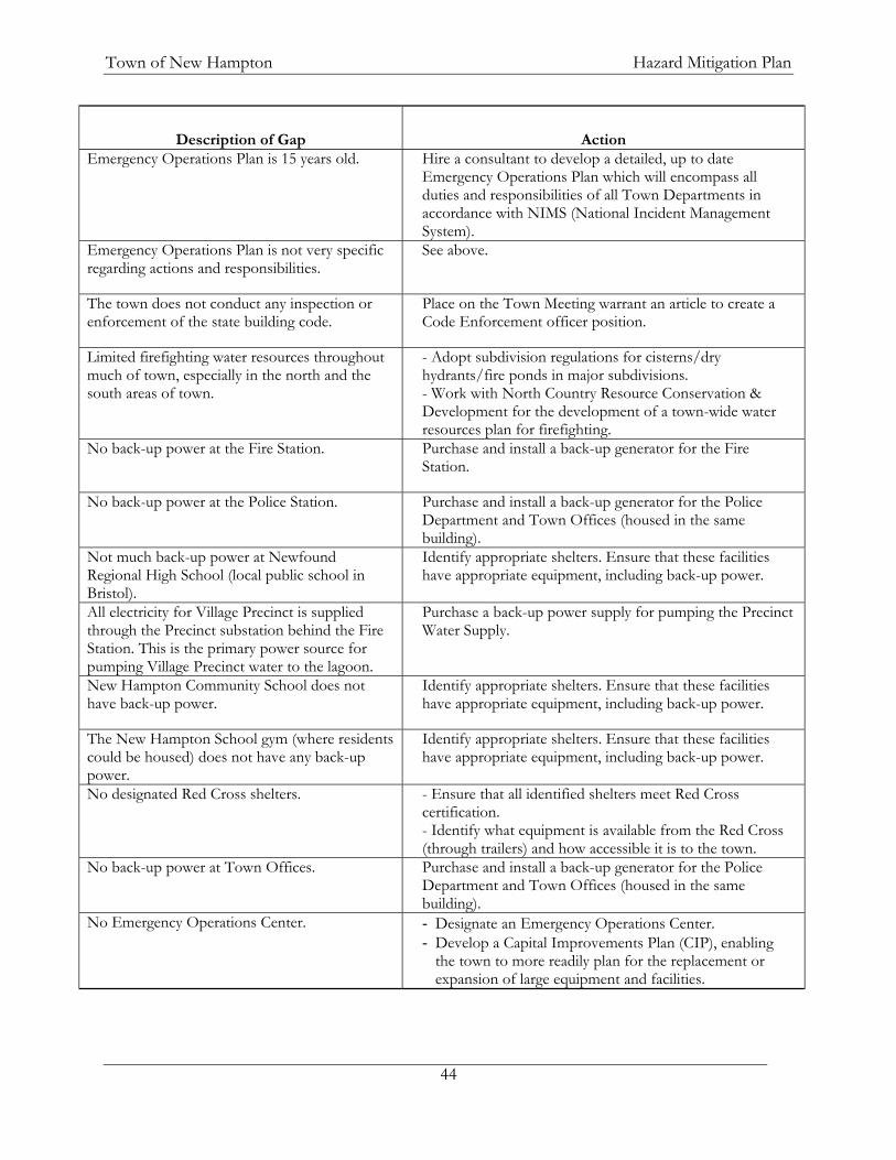
Town of New Hampton Hazard Mitigation Plan
44
Description of Gap Action Emergency Operations Plan is 15 years old. Hire a consultant to develop a detailed, up to date
Emergency Operations Plan which will encompass all duties and responsibilities of all Town Departments in accordance with NIMS (National Incident Management System).
Emergency Operations Plan is not very specific regarding actions and responsibilities.
See above.
The town does not conduct any inspection or enforcement of the state building code.
Place on the Town Meeting warrant an article to create a Code Enforcement officer position.
Limited firefighting water resources throughout much of town, especially in the north and the south areas of town.
- Adopt subdivision regulations for cisterns/dry hydrants/fire ponds in major subdivisions. - Work with North Country Resource Conservation & Development for the development of a town-wide water resources plan for firefighting.
No back-up power at the Fire Station. Purchase and install a back-up generator for the Fire Station.
No back-up power at the Police Station. Purchase and install a back-up generator for the Police Department and Town Offices (housed in the same building).
Not much back-up power at Newfound Regional High School (local public school in Bristol).
Identify appropriate shelters. Ensure that these facilities have appropriate equipment, including back-up power.
All electricity for Village Precinct is supplied through the Precinct substation behind the Fire Station. This is the primary power source for pumping Village Precinct water to the lagoon.
Purchase a back-up power supply for pumping the Precinct Water Supply.
New Hampton Community School does not have back-up power.
Identify appropriate shelters. Ensure that these facilities have appropriate equipment, including back-up power.
The New Hampton School gym (where residents could be housed) does not have any back-up power.
Identify appropriate shelters. Ensure that these facilities have appropriate equipment, including back-up power.
No designated Red Cross shelters. - Ensure that all identified shelters meet Red Cross certification. - Identify what equipment is available from the Red Cross (through trailers) and how accessible it is to the town.
No back-up power at Town Offices. Purchase and install a back-up generator for the Police Department and Town Offices (housed in the same building).
No Emergency Operations Center. - Designate an Emergency Operations Center. - Develop a Capital Improvements Plan (CIP), enabling
the town to more readily plan for the replacement or expansion of large equipment and facilities.

Town of New Hampton Hazard Mitigation Plan
45
Description of Gap Action Uncertain about the availability of the Newfound Regional School System bus fleet.
Assess the need for mass transportation for emergency/evacuation use, and subsequently enter into Memoranda of Understanding with both Newfound and New Hampton Schools for use of their bus fleets.
Availability of the New Hampton School bus fleet will vary depending upon school’s needs.
See above.
Control of privately owned dams (example, Lake Waukewan) can have a large impact on municipal facilities and threaten private properties.
- Meet with the NH DES Dam Bureau regarding dam regulations. Also meet with the town of Meredith to clarify the maintenance of water levels on Lake Waukewan.
- Identify and contact the property owners of the dams in town to ensure that regular maintenance is conducted.
While several local dams have updated emergency plans and contacts, several do not, such as Jackson Pond dam.
- Review dam Emergency Action Plans on file in the office and determine whether they are current and workable plans.
- Update out of date or unworkable dam Emergency Action Plans.
There are two “red-listed” town bridges that require attention (Brook Rd. over Blake Brook & Coolidge Woods Rd. over Wallace Brook) There is also concern with the bridge owned by the Army Corp of Engineers on Coolidge Woods Rd. over Blake Brook).
- Repair or replace the two "red-listed" bridges (Brook Rd. over Blake Brook & Coolidge Woods Rd. over Wallace Brook). - Continue funding the expendable bridge trust fund (established in 2008). - Work with the Army Corps of Engineers to expedite repair of the bridge on Coolidge Woods Rd. over Blake Brook.
Central Street Bridge could be closed during a flood event by The Army Corp of Engineers as part of the Franklin Falls Flood Control Area/Dam. With the newly constructed bridge, new closure plans and agreements will need to be negotiated with the Army Corps of Engineers.
Determine closure procedures for the Central Street Bridge along with Coolidge Woods and Brook Roads in conjunction with the US Army Corps of Engineers.
Large portion of Coolidge Woods Road could be closed during a flood event by The Army Corp of Engineers as part of the Franklin Falls Flood Control Area/Dam.
See above.
Sand and salt piles at the New Hampton DPW are uncovered, mix, and are located over the aquifer.
Construct a sand and salt shed to reduce mixing and the potential contamination of the aquifer.
The town does not have a system for notifying residents of emergency situations.
Develop an emergency notification system to notify citizens of safe evacuation routes during events.
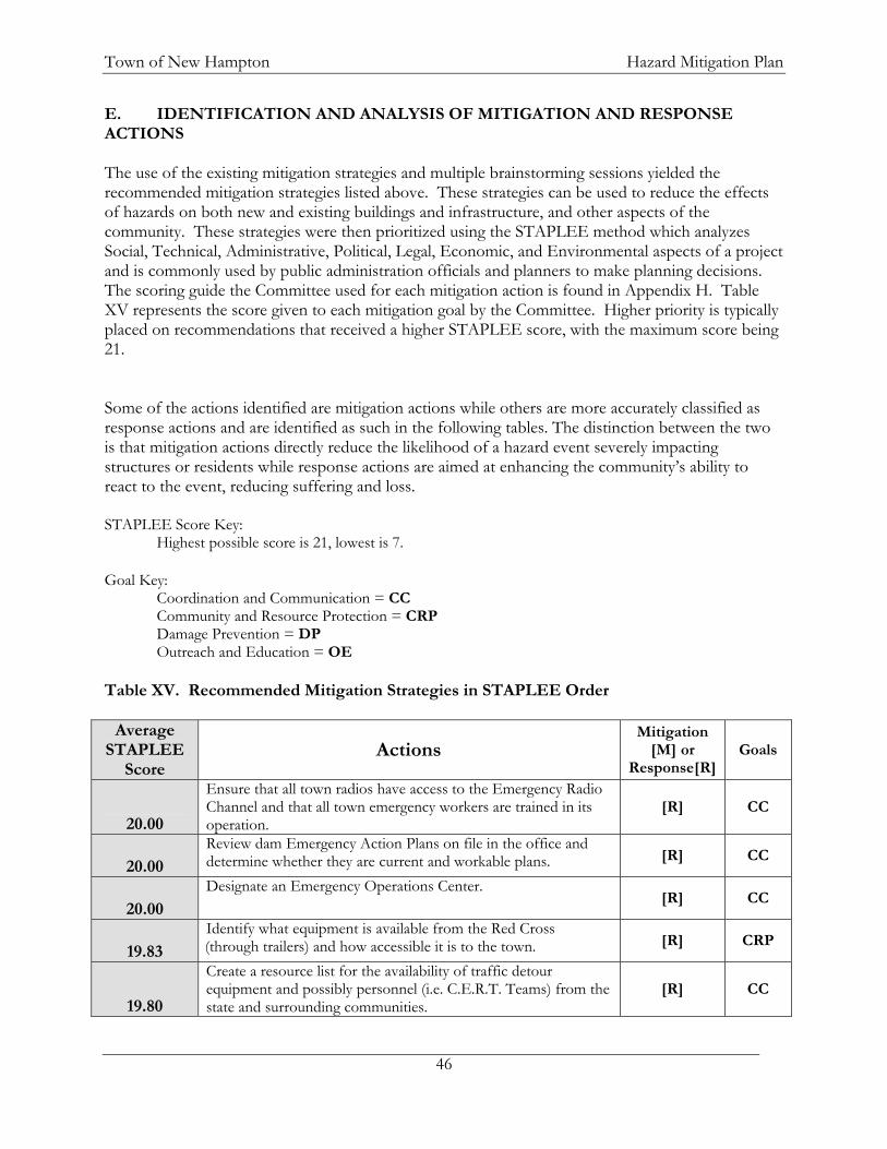
Town of New Hampton Hazard Mitigation Plan
46
E. IDENTIFICATION AND ANALYSIS OF MITIGATION AND RESPONSE ACTIONS The use of the existing mitigation strategies and multiple brainstorming sessions yielded the recommended mitigation strategies listed above. These strategies can be used to reduce the effects of hazards on both new and existing buildings and infrastructure, and other aspects of the community. These strategies were then prioritized using the STAPLEE method which analyzes Social, Technical, Administrative, Political, Legal, Economic, and Environmental aspects of a project and is commonly used by public administration officials and planners to make planning decisions. The scoring guide the Committee used for each mitigation action is found in Appendix H. Table XV represents the score given to each mitigation goal by the Committee. Higher priority is typically placed on recommendations that received a higher STAPLEE score, with the maximum score being 21. Some of the actions identified are mitigation actions while others are more accurately classified as response actions and are identified as such in the following tables. The distinction between the two is that mitigation actions directly reduce the likelihood of a hazard event severely impacting structures or residents while response actions are aimed at enhancing the community’s ability to react to the event, reducing suffering and loss. STAPLEE Score Key:
Highest possible score is 21, lowest is 7. Goal Key:
Coordination and Communication = CC Community and Resource Protection = CRP Damage Prevention = DP Outreach and Education = OE
Table XV. Recommended Mitigation Strategies in STAPLEE Order
Average STAPLEE
Score Actions
Mitigation [M] or
Response[R]Goals
20.00
Ensure that all town radios have access to the Emergency Radio Channel and that all town emergency workers are trained in its operation.
[R] CC
20.00 Review dam Emergency Action Plans on file in the office and determine whether they are current and workable plans. [R] CC
20.00 Designate an Emergency Operations Center.
[R] CC
19.83 Identify what equipment is available from the Red Cross (through trailers) and how accessible it is to the town. [R] CRP
19.80
Create a resource list for the availability of traffic detour equipment and possibly personnel (i.e. C.E.R.T. Teams) from the state and surrounding communities.
[R] CC

Town of New Hampton Hazard Mitigation Plan
47
Average STAPLEE
Score Actions
Mitigation [M] or
Response[R]Goals
19.67 Install and utilize the Emergency Management Frequency.
[R] CC
19.60 Work with NH DES to streamline the culvert replacement/ wetlands disturbance application process. [M] CC
19.60 Update out of date or unworkable dam Emergency Action Plans.
[R] CC
19.50 Identify and contact the property owners of the dams in town to ensure that regular maintenance is conducted. [M]
CRP/CC
19.40 Purchase and install a back-up generator for the Fire Station.
[R] CRP
19.40 Develop an emergency notification system to notify citizens of safe evacuation routes during events. [R] CC
19.40 Purchase a back-up power supply for pumping the Precinct Water Supply. [R] CRP
19.33 Identify appropriate shelters. Ensure that these facilities have appropriate equipment, including back-up power. [R]
CC/CRP
19.25 Replace DPW's analog radios with digital radios.
[R] CC
19.20 Ensure that all identified shelters meet Red Cross certification.
[R] CRP
19.20 Adopt and implement a fire equipment update schedule.
[R] CRP
19.00
Hire a consultant to develop a detailed, up to date Emergency Operations Plan which will encompass all duties and responsibilities of all Town Departments in accordance with NIMS (National Incident Management System).
[R] CC/C
RP
19.00 Purchase and install a back-up generator for the Police Department and Town Offices (housed in the same building). [R] CRP
19.00 Adopt and implement a DPW equipment update schedule.
[R] CRP
19.00 Inventory and maintain a database of culverts and their conditions. [M]
CC/CRP
18.83
Develop & implement a Steep Slopes Ordinance as a means of reducing erosion and ensuring that driveways are accessible to emergency vehicles
[M] DP
18.83
Meet with the NH DES Dam Bureau regarding dam regulations. Also meet with the town of Meredith to clarify the maintenance of water levels on Lake Waukewan.
[M] DP
18.80
Train police officers in HazMat response using either the New Hampshire Police Standards and Training Council or New Hampshire Fire Standards and Training.
[R] CRP
18.80 Work with New Hampshire DOT to program existing NHDOT frequency into our radios. [R] CC

Town of New Hampton Hazard Mitigation Plan
48
Average STAPLEE
Score Actions
Mitigation [M] or
Response[R]Goals
18.75 Provide more space for storage of Fire equipment.
[R] CRP
18.60 Inventory town signage and purchase sufficient signage for detouring traffic in the event of an emergency. [R] CC
18.50
Develop a Capital Improvements Plan (CIP), enabling the town to more readily plan for the replacement or expansion of large equipment and facilities.
[R] CRP
18.40 Continue funding the expendable bridge trust fund (established in 2008). [R] CRP
18.40 Construct a sand and salt shed to reduce mixing and the potential contamination of the aquifer. [M] DP
18.00 Repair or replace the two "red-listed" bridges (Brook Rd. over Blake Brook & Coolidge Woods Rd. over Wallace Brook). [M] DP
18.00 Adopt subdivision regulations for cisterns/dry hydrants/fire ponds in major subdivisions. [R] CRP
18.00 Work with the Army Corps of Engineers to expedite repair of the bridge on Coolidge Woods Rd. over Blake Brook. [M] DP
18.00
Determine closure procedures for the Central Street Bridge along with Coolidge Woods and Brook Roads in conjunction with the US Army Corps of Engineers.
[R] CC/C
RP
17.83 Place on the Town Meeting warrant an article to create a Code Enforcement officer position. [M] CRP
17.80
Install a VoIP telephone system that could be utilized in all town-owned buildings with the hub at the Town Office, and the possibility for the vendor to add more lines at a later date. This will enable the Town Offices to serve as the Emergency Operations Center and improve communication throughout town.
[R] CC
17.50
Assess the need for mass transportation for emergency/evacuation use, and subsequently enter into Memoranda of Understanding with both Newfound and New Hampton Schools for use of their bus fleets.
[R] CC/C
RP
17.40
Work with a consultant to conduct a feasibility study of the Town of New Hampton to identify an area or areas that would be suitable for an antenna for either a repeater or straight transmitter site. To share costs, partner with Lakes Region Mutual Aid and the Belknap County Sheriff Department.
[R] CC
17.40 Develop an underground water supply for the Village Precinct to reduce the likelihood of contamination or disruption. [M] DP
16.43 Adopt a zoning ordinance regulation requiring driveways to have a turnaround enabling better access with Emergency vehicles. [R] CRP
15.83 Research the cost and feasibility for cross-training town employees to augment the Fire Department's manpower needs. [R] CRP
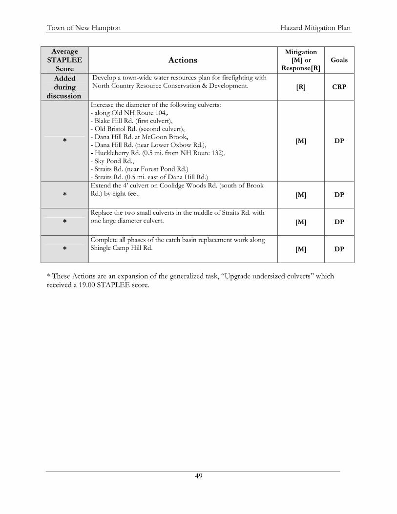
Town of New Hampton Hazard Mitigation Plan
49
Average STAPLEE
Score Actions
Mitigation [M] or
Response[R]Goals
Added during
discussion
Develop a town-wide water resources plan for firefighting with North Country Resource Conservation & Development. [R] CRP
*
Increase the diameter of the following culverts: - along Old NH Route 104,. - Blake Hill Rd. (first culvert), - Old Bristol Rd. (second culvert), - Dana Hill Rd. at McGoon Brook, - Dana Hill Rd. (near Lower Oxbow Rd.), - Huckleberry Rd. (0.5 mi. from NH Route 132), - Sky Pond Rd., - Straits Rd. (near Forest Pond Rd.) - Straits Rd. (0.5 mi. east of Dana Hill Rd.)
[M] DP
* Extend the 4’ culvert on Coolidge Woods Rd. (south of Brook Rd.) by eight feet. [M] DP
* Replace the two small culverts in the middle of Straits Rd. with one large diameter culvert.
[M] DP
* Complete all phases of the catch basin replacement work along Shingle Camp Hill Rd. [M] DP
* These Actions are an expansion of the generalized task, “Upgrade undersized culverts” which received a 19.00 STAPLEE score.

Town of New Hampton Hazard Mitigation Plan
50
F. IMPLEMENTATION OF MITIGATION AND RESPONSE ACTIONS There are many factors that influence how a town chooses to spend its energy and resources in implementing recommended actions. Factors include:
Urgency How quickly an action could be implemented Likelihood that the action will reduce future emergencies Regulations required to implement the action Administrative burdens Time (both paid and volunteer) Funding availability Political acceptability of the action.
In the context of these factors, the Committee discussed the mitigation actions and utilized the STAPLEE method as a guide to reach consensus regarding their relative level of priority, recognizing that some actions are of greater priority to different town departments. The Committee’s discussion on implementation led to the removal of a few items from the original STAPLEE list (Appendix H). This implementation schedule contains a matrix (Table XVI) indicating the parties responsible for bringing about these actions, a time frame, and potential funding sources. Also indicated in this table is whether a particular action addresses a specific hazard or multiple hazards and whether this action would primarily impact a new structure or an existing structure. These are listed in order of their Time Frame. To keep the plan current, the implementation schedule should be updated and re-evaluated on a regular basis as outlined in the monitoring section of this plan. All actions taken by the town shall comply with federal, state, and local standards. Key: BOS – Board of Selectmen, EMD – Emergency Management Director, DPW – Department of Public Works Table XVI: Implementation Schedule for Mitigation and Response Actions
*Inactive, Active, Planning
Hazard Type (E
)xist
ing/
(N)e
w
Stru
ctur
es
ACTIONS RESPONSIBLE PARTY
POTENTIAL FUNDING
TIME FRAME
STATUS*
All Hazards
Designate an Emergency Operations Center.
EMD/ BOS NA 2008 Active
All Hazards
Identify what equipment is available from the Red Cross
(through trailers) and how accessible it is to the town. EMD NA 2008 Active

Town of New Hampton Hazard Mitigation Plan
51
*Inactive, Active, Planning
Hazard Type (E
)xist
ing/
(N)e
w
Stru
ctur
es
ACTIONS RESPONSIBLE PARTY
POTENTIAL FUNDING
TIME FRAME
STATUS*
All Hazards
Hire a consultant to develop a detailed, up to date Emergency
Operations Plan which will encompass all duties and
responsibilities of all Town Departments in accordance
with NIMS (National Incident Management System). EMD/ BOS Grants 2008 Planning
Wildfire, Blizzard/
Snowstorm, Nor'easter, Ice Storm N
Adopt a zoning ordinance regulation requiring driveways to have a turnaround enabling better access with Emergency
vehicles. Planning
Board NA 2009 Active
All Hazards
Create a resource list for the availability of traffic detour
equipment and possibly personnel (i.e. C.E.R.T. Teams) from the state and surrounding
communities.
EMD/DPW Director/
Police Chief NA 2008 - 2009 Inactive
All Hazards
Install and utilize the Emergency Management
Frequency. Police Chief Departmenta
l Budgets 2008 - 2009 Inactive
Flood, Dam
Failure E, N
Meet with the NH DES Dam Bureau regarding dam
regulations. Also meet with the town of Meredith to clarify the maintenance of water levels on
Lake Waukewan. BOS/EMD NA 2008-2009 Active
Wildfire E, N
Develop a town-wide water resources plan for firefighting with North Country Resource Conservation & Development. Fire Chief
Rural Fire Protection
Grant/Town Budget
2008-2009 Active
Flood, Dam
Failure
Identify and contact the property owners of the dams in
town to ensure that regular maintenance is conducted.
EMD/ Town Office NA
2008-2009 Active
Flood, Dam
Failure
Inventory and maintain a database of culverts and their
conditions. DPW Director NA 2008-2009 Active
All Hazards
Adopt and implement a DPW equipment update schedule.
DPW DirectorTown Budget
2008-2009 Active

Town of New Hampton Hazard Mitigation Plan
52
*Inactive, Active, Planning
Hazard Type (E
)xist
ing/
(N)e
w
Stru
ctur
es
ACTIONS RESPONSIBLE PARTY
POTENTIAL FUNDING
TIME FRAME
STATUS*
Flood, Dam
Failure
Work with NH DES to streamline the culvert replacement/wetlands disturbance application
process.
Town Administrator/ DPW Director NA
2008-2009 Inactive
All Hazards
Update out of date or unworkable dam Emergency
Action Plans. EMD NA 2008-2009 Inactive
All Hazards E
Identify appropriate shelters. Ensure that these facilities have
appropriate equipment, including back-up power. EMD Grants
2008-2009 Planning
All Hazards E
Ensure that all identified shelters meet Red Cross
certification. EMD NA 2008-2009 Planning
All Hazards
Ensure that all town radios have access to the Emergency Radio
Channel and that all town emergency workers are trained
in its operation. Police Chief/
EMD Operating
Budget 2009 Active
All Hazards
Purchase a back-up power supply for pumping the Precinct Water Supply.
New Hampton Village
Precinct (NHVP) NHVP 2009 Active
All Hazards N
Develop & implement a Steep Slopes Ordinance as a means of reducing erosion and ensuring that driveways are accessible to
emergency vehicles Planning
Board Town Budget 2009 Active
Wildfire, Flood, Dam
Failure E
Purchase and install a back-up generator for the Fire Station.
BOS/ Fire Chief
Hazard Mitigation
grant 2009 PlanningWildfire, Flood, Dam
Failure
Adopt and implement a fire equipment update schedule.
Fire Chief
Grants/ Special
Revenue/ Budget 2009 Planning
Wildfire N
Adopt subdivision regulations for cisterns/dry hydrants/fire ponds in major subdivisions.
Planning Board NA 2009 Planning
Wildfire E, N
Research the cost and feasibility for cross-training town
employees to augment the Fire Department's manpower needs. EMD/ BOS
Town Budget 2009 Planning

Town of New Hampton Hazard Mitigation Plan
53
*Inactive, Active, Planning
Hazard Type (E
)xist
ing/
(N)e
w
Stru
ctur
es
ACTIONS RESPONSIBLE PARTY
POTENTIAL FUNDING
TIME FRAME
STATUS*
HazMat Vehicle
Accident
Train police officers in HazMat response using either the New Hampshire Police Standards and Training Council or New Hampshire Fire Standards and
Training. Police Chief NA 2009 Planning
Flooding E
Determine closure procedures for the Central Street Bridge
along with Coolidge Woods and Brook Roads in conjunction with the US Army Corps of
Engineers. EMD/ BOS NA 2009 Planning
All Hazards E
Purchase and install a back-up generator for the Police
Department and Town Offices (housed in the same building). Police Chief
Grants/ Town Budget 2009 Planning
All Hazards
Develop a Capital Improvements Plan (CIP), enabling the town to more
readily plan for the replacement or expansion of large
equipment and facilities. Planning
Board Town Budget 2009 Planning
All Hazards
Assess the need for mass transportation for
emergency/evacuation use, and subsequently enter into
Memoranda of Understanding with both Newfound and New Hampton Schools for use of
their bus fleets. EMD NA 2009 Planning
Flood, Dam
Failure E, N
Review dam Emergency Action Plans on file in the office and determine whether they are current and workable plans. EMD NA
2009 - 2010 Inactive
All Hazards
Develop an emergency notification system to notify citizens of safe evacuation
routes during events. EMD Grants 2009 - 2010 Planning
All Hazards
Replace DPW's analog radios with digital radios.
DPW Director Grants 2009 - 2012 Planning

Town of New Hampton Hazard Mitigation Plan
54
*Inactive, Active, Planning
Hazard Type (E
)xist
ing/
(N)e
w
Stru
ctur
es
ACTIONS RESPONSIBLE PARTY
POTENTIAL FUNDING
TIME FRAME
STATUS*
Water Contami-
nation
Develop an underground water supply for the Village Precinct
to reduce the likelihood of contamination or disruption. NHVP NHVP
2009-2010 Active
Blizzard/ Snowstorm, Nor'easter, Ice Storm N
Construct a sand and salt shed to reduce mixing and the
potential contamination of the aquifer.
DPW Director/ BOS
Capital Reserve/
Town Meeting
2009-2010 Active
All Hazards
Inventory town signage and purchase sufficient signage for detouring traffic in the event of
an emergency. EMD/DPW
Director Town Budget
2009-2010 Planning
All Hazards
Install a VoIP telephone system that could be utilized in all
town-owned buildings with the hub at the Town Office, and
the possibility for the vendor to add more lines at a later date.
This will enable the Town Offices to serve as the
Emergency Operations Center and improve communication
throughout town. Police
Chief/EMD
Town Meeting/ Grants
2009-2011 Planning
Flooding E
Continue funding the expendable bridge trust fund
(established in 2008). BOS Town
Meeting 2009-2012 Active
Flooding E
Increase the diameter of the following culverts:
- along Old NH Route 104,. - Blake Hill Rd. (first culvert),
- Old Bristol Rd. (second culvert), - Dana Hill Rd. at McGoon Brook,
- Dana Hill Rd. (near Lower Oxbow Rd.),
- Huckleberry Rd. (0.5 mi. from NH Route 132), - Sky Pond Rd.,
- Straits Rd. (near Forest Pond Rd.) - Straits Rd. (0.5 mi. east of Dana
Hill Rd.) DPW Director
Town funding and
FEMA grants
2009-2012 Planning
Flooding
Extend the 4’ culvert on Coolidge Woods Rd. (south of
Brook Rd.) by eight feet. DPW Director
Town funding and
FEMA grants
2009-2012 Planning

Town of New Hampton Hazard Mitigation Plan
55
*Inactive, Active, Planning
Hazard Type (E
)xist
ing/
(N)e
w
Stru
ctur
es
ACTIONS RESPONSIBLE PARTY
POTENTIAL FUNDING
TIME FRAME
STATUS*
Flooding
Replace the two small culverts in the middle of Straits Rd. with
one large diameter culvert. DPW Director
Town funding and
FEMA grants
2009-2012 Planning
Flooding E
Complete all phases of the catch basin replacement work along
Shingle Camp Hill Rd. DPW Director
Town funding and
FEMA grants
2009-2012 Active
All Hazards
Work with New Hampshire DOT to program existing
NHDOT frequency into our radios.
DPW Director/
EMD NA 2009-2012 Planning
All Hazards N
Place on the Town Meeting warrant an article to create a Code Enforcement officer
position. BOS Town
Meeting 2009-2012 Planning
All Hazards
Work with a consultant to conduct a feasibility study of
the Town of New Hampton to identify an area or areas that
would be suitable for an antenna for either a repeater or
straight transmitter site. To share costs, partner with Lakes
Region Mutual Aid and the Belknap County Sheriff
Department. EMD/ Police
Chief
Grants/ Belknap County/
Town Budget
2009-2012 Planning
Wildfire E
Provide more space for storage of Fire equipment.
BOS Town
Meeting 2009-2014 Planning
Flood, Dam
Failure E
Repair or replace the two "red-listed" bridges (Brook Rd. over
Blake Brook & Coolidge Woods Rd. over Wallace
Brook). DPW
Director/ BOS
State Bridge Aid/
Expendable Trust
2010-2012 Active
Flooding E
Work with the Army Corps of Engineers to expedite repair of the bridge on Coolidge Woods
Rd. over Blake Brook. BOS/DPW
Director Army Corps of Engineers
2010-2012 Planning

Town of New Hampton Hazard Mitigation Plan
56
CHAPTER VI: PLAN ADOPTION AND MONITORING A. IMPLEMENTATION The Hazard Mitigation Plan Evaluation Committee, established by the Selectboard and EMD, will meet annually and provide a mechanism for ensuring that an attempt is made to incorporate the actions identified in the plan into ongoing town planning activities. Essential elements of implementation require all responsible parties for the various recommendations understand what is expected of them, and that they are willing to fulfill their role in implementation. It is therefore important to have the responsible parties clearly identified when the town adopts the final plan. Where appropriate it would be helpful to have any hazard mitigation activities identified in job descriptions. NH RSA 674:2(e) makes the recommendation that a natural hazard section may be included in the town master plan. Inclusion of this document as an addendum to the New Hampton Master Plan provides an opportunity for issues addressed in this plan to be taken into consideration when planning for development within the community. The capital improvement planning that occurs in the future will also contribute to the goals in the Hazard Mitigation Plan. When appropriate, an effort will be made to incorporate this plan into the New Hampton Master Plan, the New Hampton Capital Improvements Plan, and the Emergency Operations Plan. Within a year after the town officially adopts the Hazard Mitigation Plan, an attempt will be made to have hazard mitigation strategies integrated into these existing mechanisms and into all other ongoing town planning activities. B. PLAN MAINTENANCE The New Hampton Hazard Mitigation Planning Committee and the Board of Selectmen, in order to track progress and update the mitigation strategies identified in Chapter V-E, will review the New Hampton Hazard Mitigation Plan every year or after a hazard event. The town of New Hampton Emergency Management Director is responsible for initiating this review and needs to consult with members of the New Hampton Committee identified in this Plan. Changes will be made to the Plan to accommodate projects that have failed, or are no longer: (1) consistent with the timeframe identified, (2) the community's priority, (3) lack funding resources. Priorities that were not ranked high, but identified as potential mitigation strategies, will be reviewed during the monitoring and update of this Plan to determine feasibility of future implementation. In keeping with the process of adopting the Plan, a public hearing will be held to receive public comment on the Plan. Maintenance and updating will be held during the annual review period, best suggested time is mid-year, and the final product adopted by the Board of Selectmen. The Committee will meet quarterly as part of this plan maintenance. The Emergency Management Director is also responsible for resubmitting the updated plan to FEMA every five years. C. ADOPTION The New Hampton Board of Selectmen by majority vote does hereby adopt the New Hampton Hazard Mitigation Plan, as a statement of policy. Actions for implementation under this statement

Town of New Hampton Hazard Mitigation Plan
57
of policy are set forth in priority order in the "Implementation of Mitigation Actions" and "Plan Maintenance" sections of this document. All other sections of this Plan are supporting documentation for informational purposes only and not included as the statement of policy. NEW HAMPTON BOARD OF SELECTMEN Merritt D. Salmon, Selectman Charles W. Bartley, Selectman Paul J. Tierney, Selectman ______________ Date
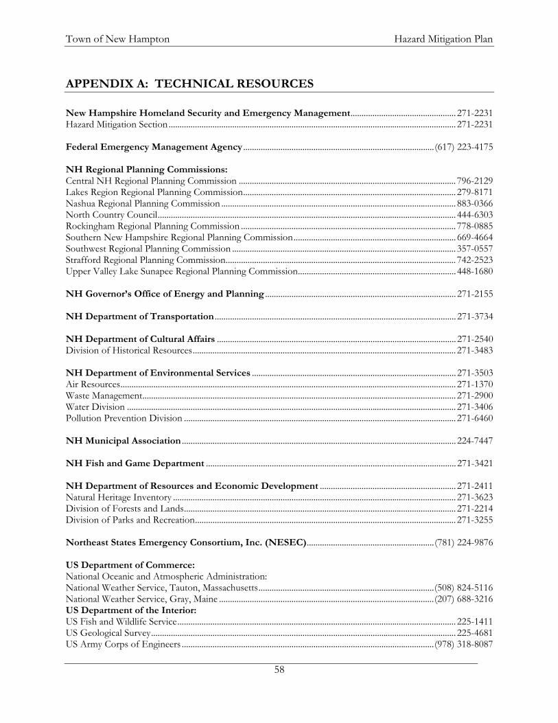
Town of New Hampton Hazard Mitigation Plan
58
APPENDIX A: TECHNICAL RESOURCES New Hampshire Homeland Security and Emergency Management................................................ 271-2231 Hazard Mitigation Section................................................................................................................................... 271-2231 Federal Emergency Management Agency .......................................................................................(617) 223-4175 NH Regional Planning Commissions: Central NH Regional Planning Commission ................................................................................................... 796-2129 Lakes Region Regional Planning Commission................................................................................................. 279-8171 Nashua Regional Planning Commission ........................................................................................................... 883-0366 North Country Council........................................................................................................................................ 444-6303 Rockingham Regional Planning Commission .................................................................................................. 778-0885 Southern New Hampshire Regional Planning Commission.......................................................................... 669-4664 Southwest Regional Planning Commission ...................................................................................................... 357-0557 Strafford Regional Planning Commission......................................................................................................... 742-2523 Upper Valley Lake Sunapee Regional Planning Commission........................................................................ 448-1680 NH Governor’s Office of Energy and Planning ....................................................................................... 271-2155 NH Department of Transportation .............................................................................................................. 271-3734 NH Department of Cultural Affairs ............................................................................................................. 271-2540 Division of Historical Resources........................................................................................................................ 271-3483 NH Department of Environmental Services ............................................................................................. 271-3503 Air Resources......................................................................................................................................................... 271-1370 Waste Management............................................................................................................................................... 271-2900 Water Division ...................................................................................................................................................... 271-3406 Pollution Prevention Division ............................................................................................................................ 271-6460 NH Municipal Association ............................................................................................................................. 224-7447 NH Fish and Game Department .................................................................................................................. 271-3421 NH Department of Resources and Economic Development .............................................................. 271-2411 Natural Heritage Inventory ................................................................................................................................. 271-3623 Division of Forests and Lands............................................................................................................................ 271-2214 Division of Parks and Recreation....................................................................................................................... 271-3255 Northeast States Emergency Consortium, Inc. (NESEC)..........................................................(781) 224-9876 US Department of Commerce: National Oceanic and Atmospheric Administration: National Weather Service, Tauton, Massachusetts................................................................................(508) 824-5116 National Weather Service, Gray, Maine ..................................................................................................(207) 688-3216 US Department of the Interior: US Fish and Wildlife Service............................................................................................................................... 225-1411 US Geological Survey........................................................................................................................................... 225-4681 US Army Corps of Engineers ...................................................................................................................(978) 318-8087

Town of New Hampton Hazard Mitigation Plan
59
Public Service of New Hampshire................................................................................................................ 436-7708 Cold Region Research Laboratory................................................................................................................ 646-4187 Websites:
Sponsor Internet Address Summary of Contents
Natural Hazards Center, University of Colorado http://www.colorado.edu/hazards/ Searchable database of references and links
to many disaster-related websites.
The University of Illinois http://ww2010.atmos.uiuc.edu/(Gh)/guides/mtr/hurr/home.rxml
Interact with Atlantic hurricanes from 1950 – 2003.
National Emergency Management Association http://nemaweb.org
Association of state emergency management directors; list of mitigation projects.
NASA – Goddard Space Flight Center “Disaster Finder: http://www.gsfc.nasa.gov/ndrd/disaster/
Searchable database of sites that encompass a wide range of natural disasters.
NASA Natural Disaster Reference Database
http://ltpwww.gsfc.nasa.gov/ndrd/main/html
Searchable database of worldwide natural disasters.
U.S. State & Local Gateway http://www.statelocal.gov/ General information through the federal-state partnership.
National Weather Service http://nws.noaa.gov/ Central page for National Weather Warnings, updated every 60 seconds.
USGS Real Time Hydrologic Data http://waterdata.usgs.gov/nwis/rt Provisional hydrological data
Dartmouth Flood Observatory http://www.dartmouth.edu/artsci/geog/floods/ Observations of flooding situations.
FEMA, National Flood Insurance Program, Community Status Book http://www.fema.gov/fema/csb.htm Searchable site for access of Community
Status Books Florida State University Atlantic Hurricane Site
http://www.met.fsu.edu/explores/tropical.html
Tracking and NWS warnings for Atlantic Hurricanes and other links
National Lightning Safety Institute http://lightningsafety.com/ Information and listing of appropriate publications regarding lightning safety.
NASA Optical Transient Detector http://www.ghcc.msfc.nasa.gov/otd.html Space-based sensor of lightning strikes
LLNL Hazards Mitigation Center http://www.llnl.gov/hmc/ General hazard information developed for the Dept. of Energy.
The Tornado Project Online http://www.tornadoproject.com/ Information on tornadoes, including details of recent impacts.
National Severe Storms Laboratory http://www.oar.noaa.gov/atmosphere/atmos_nssl.html
Information about and tracking of severe storms.
Earth Satellite Corporation http://www.earthsat.com/ Flood risk maps searchable by state.
USDA Forest Service Web http://www.fs.fed.us/land Information on forest fires and land management.
Northeast States Emergency Consortium http://www.serve.com/NESEC/ Maps and information on local hazards,
both historic and potential. State of NH Natural Hazards Mitigation (409) Plan
http://www.nhoem.state.nh.us/mitigation/default.htm
State goals, information and mitigation plans, funding sources and applications.
NH State Parks http://www.nhstateparks.com/rabies.html Information on Rabies
NH Fish and Game http://www.wildlife.state.nh.us/Wildlife/Wildlife_PDFs/rabies_brochure.pdf Rabies Information Pamphlet
NH Department of Health and Human Services
http://www.dhhs.state.nh.us/DHHS/CDCS/LIBRARY/Fact+Sheet/rabies.htm Fact sheets about rabies.
NH Department of Health and Human Services
http://www.dhhs.state.nh.us/DHHS/CDCS/LIBRARY/Fact+Sheet/PPCC-AHR-Map.htm
Pandemic regions and coordinators

Town of New Hampton Hazard Mitigation Plan
60
APPENDIX B: MITIGATION FUNDING RESOURCES 404 Hazard Mitigation Grant Program (HMGP) ............. NH Homeland Security and Emergency Management
406 Public Assistance and Hazard Mitigation................... NH Homeland Security and Emergency Management
Community Development Block Grant (CDBG) .................................. NH HSEM, NH OEP, also refer to RPC
Dam Safety Program .............................................................................. NH Department of Environmental Services
Disaster Preparedness Improvement Grant (DPIG)....... NH Homeland Security and Emergency Management
Emergency Generators Program by NESEC.................... NH Homeland Security and Emergency Management
Emergency Watershed Protection (EWP) Program...................USDA, Natural Resources Conservation Service
Flood Mitigation Assistance Program (FMAP) ................ NH Homeland Security and Emergency Management
Flood Plain Management Services (FPMS) ..................................................................US Army Corps of Engineers
Mitigation Assistance Planning (MAP)............................... NH Homeland Security and Emergency Management
Mutual Aid for Public Works...............................................................................................NH Municipal Association
National Flood Insurance Program (NFIP) ..........................................................NH Office of Energy & Planning
Power of Prevention Grant by NESEC............................. NH Homeland Security and Emergency Management
Project Impact ........................................................................ NH Homeland Security and Emergency Management
Roadway Repair & Maintenance Program(s) .....................................................NH Department of Transportation
Section 14 Emergency Stream Bank Erosion & Shoreline Protection ................... US Army Corps of Engineers
Section 103 Beach Erosion .............................................................................................US Army Corps of Engineers
Section 205 Flood Damage Reduction..........................................................................US Army Corps of Engineers
Section 2098 Snagging and Clearing ..............................................................................US Army Corps of Engineers
Shoreline Protection Program .............................................................. NH Department of Environmental Services
Various Forest and Lands Program(s)........................NH Department of Resources & Economic Development
Wetlands Programs................................................................................. NH Department of Environmental Services

Town of New Hampton Hazard Mitigation Plan
61

Town of New Hampton Hazard Mitigation Plan
62
APPENDIX C: PUBLIC NOTICE EXAMPLE and WEB POSTINGS
New Hampton Hazard Mitigation Planning Committee
The next meeting of the New Hampton Hazard Mitigation Plan Committee will be held Monday
July 28, 2008 from 2:30 - 4:00 PM in the New Hampton Town Offices.
The Committee will be discussing Man-made/Terrorist Risk, Existing Protections, Gaps in the
Existing Policies/Protections, and Disaster Mitigation Alternatives.
The general public is encouraged to attend. For more information please call the New Hampton
Town Offices at 744-3559 or the Lakes Region Planning Commission at 279-8171.

Town of New Hampton Hazard Mitigation Plan
63
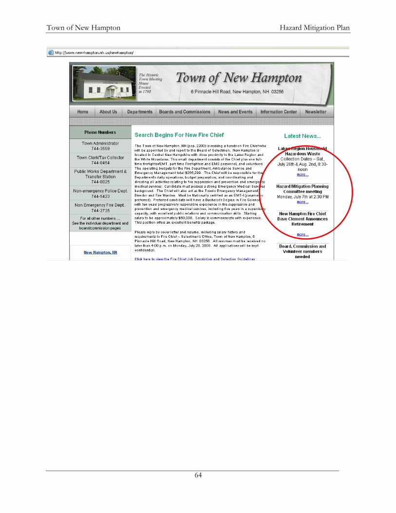
Town of New Hampton Hazard Mitigation Plan
64

Town of New Hampton Hazard Mitigation Plan
65

Town of New Hampton Hazard Mitigation Plan
66

Town of New Hampton Hazard Mitigation Plan
67
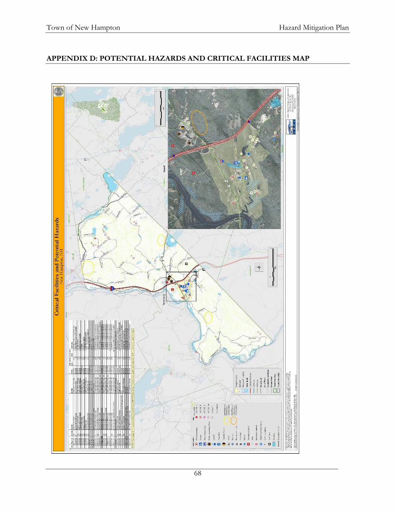
Town of New Hampton Hazard Mitigation Plan
68
APPENDIX D: POTENTIAL HAZARDS AND CRITICAL FACILITIES MAP

Town of New Hampton Hazard Mitigation Plan
69

Town of New Hampton Hazard Mitigation Plan
70
APPENDIX E: MANMADE/TERRORIST RISK TO CRITICAL FACILITIES
TYPE Facility/Infrastructure Total
Structure Transfer Station 1
Public Works\Hwy Dept Town Highway Garage 1 Town Offices Town Offices 2 Sewage Treatment Facility Village Precinct Sewage Treatment Facility 1 Day Care Annie's Place 2 Day Care Day Care Center 2 Elderly Housing (under construction) 1 School New Hampton School 2
Structure Cistern 1 Communication Direct TV (emergency broadband) 2 Structure Village Precinct Electrical Substation 1 Essential Services NH DOT Highway Garage 1
Town House Town Meeting House 1
Police Department Police Department 2
Library Gordon-Nash Library 1
School New Hampton Community School 2
Fire Department Fire Department 2 Water Supply Village Precinct Water Facility 3 Evacuation Route NH Rte 104 3 Evacuation Route NH Rte 132 3 Evacuation Route I - 93 3 Evacuation Route Winona Rd 2 Evacuation Route Dana Hill Rd 2 Evacuation Route Old Bristol Rd 2 Bridge NH 104 Bridge 3 Bridge Central Street Bridge 1
Dam Dickerman Dam (includes Precinct water and sewer) 2
Dam Ayers Island Dam 1
Classification Types: Priority Based On: Vulnerability Key:
Essential Services Visibility 3 = high Emergency Shelters Target 2 = medium Populations to protect Access 1 = low Structures and Services Mobility Other Hazard Materials Collateral Damage Population Impact

Town of New Hampton Hazard Mitigation Plan
71
APPENDIX F: CRITICAL FACILITIES NATURAL HAZARDS VULNERABILITY ASSESSMENT
High = 3, Moderate = 2, Low = 1
Town Facility/Infrastructure
Wild
fire
Flo
od
Bliz
zard
/
Snow
stor
m
Nor
'eas
ter
Ice
Stor
m
Dam
Fai
lure
Total Transfer Station 1 1 1 1 1 1 6
Town Highway Garage 1 1 2 3 1 1 9 Town Offices 1 1 1 2 2 1 8
Village Precinct Sewage Treatment Facility 1 2 1 1 2 2 9 Cistern 1 1 1 1 1 1 6
Village Precinct Electrical Substation 1 1 1 1 2 1 7
NH DOT Highway Garage 1 1 1 2 1 1 7
Town Meeting House 1 1 2 2 1 1
Police Department 1 1 1 2 2 1 8
Gordon-Nash Library 1 1 1 1 1 1 6
New Hampton Community School 1 1 2 3 2 1 10
Fire Department 1 1 2 3 2 1 10
Village Precinct Water Facility 1 2 1 1 2 2 9
Power Substations 1 1 1 1 2 1 7
Total 14 16 18 24 22 16

Town of New Hampton Hazard Mitigation Plan
72
APPENDIX G: RISK ASSESSMENT MATRIX Risk Assessment: New Hampton
Geographic Area Extent Specific Areas of
Concern Probability of Occurrence Vulnerability
Hazard Type
Loca
lized
Tow
n-w
ide
Regi
onal
Stat
e-w
ide
Oth
er (e
xplai
n)
Seve
re
Mod
erat
e
Min
imal
Describe potential impact areas (critical facilities, floodplain,
etc)
Hig
h =
3
Mod
erat
e =
2
Low
= 1
Hig
h =
3
Mod
erat
e =
2
Low
= 1
Risk Rating
Flood, Drought, Extreme Heat & Wildfire
Flood X X* X *Past assistance has involved federal $ 3 2 6
Dam Failure X X
Probability - Ayers Island Low, smaller dams - High 2 2 4
Ice Jam X X X
Jellystone Campground, scouring of NH Rte 104 Bridge 1 1 1
Drought X Would affect the Village Precinct 1 3 3
Conflagration X X Jellystone Campground 1 1 1
Extreme Heat X 1 2 2 Wildfire X X Few fires over 5 acres 2 2 4 Geologic Hazards Earthquake X X New Hampton School 1 2 2
Landslide X X
Driveways, Pemigewasset River banks 1 1 1
Radon X * *in groundwater 3 1 3 Severe Wind Hazards
Thunderstorm/ Lightning X X 3 1 3 Hurricane X X 1 2 2
Tornado/Downburst X X 1 2 2 Hail X X 1 1 1 Winter Weather Hazards
Blizzard/Snow Storm X X
Equipment updates are needed 3 2 6
Ice Storm X X Backup generators are needed 2 3 6
Nor'easter X X 3 2 6
Avalanche Not Applicable 1 1 1

Town of New Hampton Hazard Mitigation Plan
73
Risk Assessment: New Hampton
Geographic Area Extent Specific Areas of
Concern Probability of Occurrence Vulnerability
Hazard Type
Loca
lized
Tow
n-w
ide
Regi
onal
Stat
e-w
ide
Oth
er (e
xplai
n)
Seve
re
Mod
erat
e
Min
imal
Describe potential impact areas (critical facilities, floodplain,
etc)
Hig
h =
3
Mod
erat
e =
2
Low
= 1
Hig
h =
3
Mod
erat
e =
2
Low
= 1
Risk Rating
Human-Related Events
MV Accident involving Hazardous Materials X X I-93/NH Rte 104 3 2 6
Oil or Propane Spill X X
A spill into surface water would quickly move downstream. 2 3 6
Military Aircraft Accident X X 1 1 1 Pandemic X X 1 3 3

Town of New Hampton Hazard Mitigation Plan
74
APPENDIX H: STAPLEE RESULTS This section contains a summary of STAPLEE rankings for each of the proposed Mitigation Actions by the New Hampton Hazard Mitigation Committee. The highest possible rank in each of the seven categories is 3.0, the lowest is 1.0. The scores for each of the criteria have been averaged and then totaled.
AVERAGE NEW HAMPTON HMP
STAPLEE Mitigation Actions SUMMARY TABLE
Socia
lly
Acc
epta
ble?
Tech
nica
lly
feas
ible?
Adm
inist
rativ
ely
Wor
kabl
e?
Polit
ically
A
ccep
tabl
e?
Lega
l Aut
horit
y?
Eco
nom
ically
Be
nefic
ial?
Env
ironm
enta
lly
Goo
d or
Bad
?
Tot
al
Obtain a Model Steep Slopes Ordinance from LRPC and present to the Planning Board for consideration as a means of reducing erosion and ensuring that driveways are accessible to Emergency vehicles. 2.50 2.83 2.67 2.33 2.83 2.67 3.00 18.83 Present to the Planning Board for possible adoption a zoning ordinance regulation requiring driveways to have a turnaround enabling better access with Emergency vehicles. 2.17 2.33 2.50 2.00 2.33 2.50 2.60 16.43 Review NFPA standards for residential sprinkler systems and consider for possible zoning ordinance regulation. 1.83 2.33 2.33 1.83 2.33 2.00 2.50 15.17 Install and utilize the Emergency Management Frequency. 3.00 3.00 2.83 2.83 2.83 2.67 2.50 19.67 Replace DPW's analog radios with digital radios. 2.75 3.00 2.75 2.75 2.75 2.50 2.75 19.25 Work with New Hampshire DOT to program existing NHDOT frequency into our radios. 2.80 2.60 2.60 2.60 2.80 2.60 2.80 18.80 Work with a consultant to conduct a feasibility study of the Town of New Hampton to identify an area or areas that would be suitable for an antenna for either a repeater or straight transmitter site. To share costs, partner with Lakes Region Mutual Aid and the Belknap County Sheriff Department. 2.60 2.40 2.40 2.60 2.60 2.20 2.60 17.40
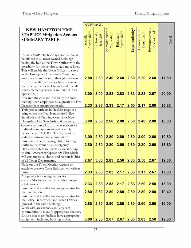
Town of New Hampton Hazard Mitigation Plan
75
AVERAGE NEW HAMPTON HMP
STAPLEE Mitigation Actions SUMMARY TABLE
Socia
lly
Acc
epta
ble?
Tech
nica
lly
feas
ible?
Adm
inist
rativ
ely
Wor
kabl
e?
Polit
ically
A
ccep
tabl
e?
Lega
l Aut
horit
y?
Eco
nom
ically
Be
nefic
ial?
Env
ironm
enta
lly
Goo
d or
Bad
?
Tot
al
Install a VoIP telephone system that could be utilized in all town-owned buildings having the hub at the Town Office, with the possibility for the vendor to add more lines. This will enable the Town Offices to serve as the Emergency Operations Center and improve communication throughout town. 2.80 2.60 2.40 2.60 2.60 2.20 2.60 17.80 Ensure that all town radios have access to the Emergency Radio Channel and that all town emergency workers are trained in its operation. 3.00 3.00 2.83 2.83 2.83 2.83 2.67 20.00 Research the cost and feasibility for cross training town employees to augment the Fire Department's manpower needs. 2.33 2.33 2.33 2.17 2.50 2.17 2.00 15.83 Train police officers in HazMat response using either the New Hampshire Police Standards and Training Council or New Hampshire Fire Standards and Training. 3.00 2.60 2.60 2.80 2.60 2.40 2.80 18.80 Create a resource list for the availability of traffic detour equipment and possibly personnel (i.e. C.E.R.T. Teams) from the state and surrounding communities. 3.00 2.80 2.80 2.80 2.80 3.00 2.60 19.80 Purchase sufficient signage for detouring traffic in the event of an emergency. 2.80 2.80 2.80 2.60 2.80 2.20 2.60 18.60 Hire a consultant to develop a detailed, up to date Emergency Operations Plan which will encompass all duties and responsibilities of all Town Departments. 2.67 3.00 2.83 2.50 2.83 2.50 2.67 19.00 Place on the Town Meeting warrant an article to create a Code Enforcement officer position. 2.33 2.83 2.83 2.17 2.83 2.17 2.67 17.83 Adopt subdivision regulations for cisterns/dry hydrants/fire ponds in major subdivisions. 2.33 2.83 2.83 2.17 2.83 2.50 2.50 18.00 Purchase and install a back-up generator for the Fire Station. 2.80 2.60 2.80 2.80 2.80 2.80 2.80 19.40 Purchase and install a back-up generator for the Police Department and Town Offices (housed in the same building). 2.80 2.60 2.80 2.80 2.80 2.60 2.60 19.00 Work with area schools and adjacent communities to identify appropriate shelters. Ensure that these facilities have appropriate equipment, including back-up power. 3.00 2.83 2.67 2.67 2.83 2.83 2.50 19.33
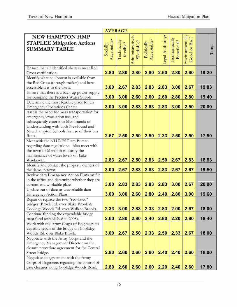
Town of New Hampton Hazard Mitigation Plan
76
AVERAGE NEW HAMPTON HMP
STAPLEE Mitigation Actions SUMMARY TABLE
Socia
lly
Acc
epta
ble?
Tech
nica
lly
feas
ible?
Adm
inist
rativ
ely
Wor
kabl
e?
Polit
ically
A
ccep
tabl
e?
Lega
l Aut
horit
y?
Eco
nom
ically
Be
nefic
ial?
Env
ironm
enta
lly
Goo
d or
Bad
?
Tot
al
Ensure that all identified shelters meet Red Cross certification. 2.80 2.80 2.80 2.80 2.60 2.80 2.60 19.20 Identify what equipment is available from the Red Cross (through trailers) and how accessible it is to the town. 3.00 2.67 2.83 2.83 2.83 3.00 2.67 19.83 Ensure that there is a back-up power supply for pumping the Precinct Water Supply. 3.00 3.00 2.60 2.60 2.60 2.80 2.80 19.40 Determine the most feasible place for an Emergency Operations Center. 3.00 3.00 2.83 2.83 2.83 3.00 2.50 20.00 Assess the need for mass transportation for emergency/evacuation use, and subsequently enter into Memoranda of Understanding with both Newfound and New Hampton Schools for use of their bus fleets. 2.67 2.50 2.50 2.50 2.33 2.50 2.50 17.50 Meet with the NH DES Dam Bureau regarding dam regulations. Also meet with the town of Meredith to clarify the maintenance of water levels on Lake Waukewan. 2.83 2.67 2.50 2.83 2.50 2.67 2.83 18.83 Identify and contact the property owners of the dams in town. 3.00 2.67 2.83 2.83 2.83 2.67 2.67 19.50 Review dam Emergency Action Plans on file in the office and determine whether they are current and workable plans. 3.00 2.83 2.83 2.83 2.83 3.00 2.67 20.00 Update out of date or unworkable dam Emergency Action Plans. 3.00 3.00 2.60 2.80 2.40 2.80 3.00 19.60 Repair or replace the two "red-listed" bridges (Brook Rd. over Blake Brook & Coolidge Woods Rd. over Wallace Brook). 2.33 3.00 2.83 2.33 2.83 2.00 2.67 18.00 Continue funding the expendable bridge trust fund (established in 2008). 2.60 2.80 2.80 2.40 2.80 2.20 2.80 18.40 Work with the Army Corps of Engineers to expedite repair of the bridge on Coolidge Woods Rd. over Blake Brook. 3.00 2.67 2.50 2.33 2.50 2.33 2.67 18.00 Negotiate with the Army Corps and the Emergency Management Director on the closure procedure agreement for the Central Street Bridge. 2.80 2.60 2.60 2.60 2.40 2.40 2.60 18.00 Negotiate an agreement with the Army Corps of Engineers regarding the control of gate closures along Coolidge Woods Road. 2.80 2.60 2.60 2.60 2.20 2.40 2.60 17.80

Town of New Hampton Hazard Mitigation Plan
77
AVERAGE NEW HAMPTON HMP
STAPLEE Mitigation Actions SUMMARY TABLE
Socia
lly
Acc
epta
ble?
Tech
nica
lly
feas
ible?
Adm
inist
rativ
ely
Wor
kabl
e?
Polit
ically
A
ccep
tabl
e?
Lega
l Aut
horit
y?
Eco
nom
ically
Be
nefic
ial?
Env
ironm
enta
lly
Goo
d or
Bad
?
Tot
al
For Roads and bridges, along with any other emergency that mandates evacuation, the Town should develop an emergency notification system for the event to notify citizens of safe evacuation routes. 2.80 3.00 2.60 2.80 2.80 2.80 2.60 19.40 Develop a Capital Improvements Plan (CIP), enabling the town to more readily plan for large equipment and facilities replacement or expansion. 2.67 2.83 2.83 2.50 2.83 2.33 2.50 18.50 Adopt and implement a fire equipment update schedule. 2.80 3.00 2.80 2.80 2.80 2.40 2.60 19.20 Purchase HazMat equipment for Fire Department and provide appropriate training in its use. 3.00 3.00 2.80 2.80 2.80 2.60 2.80 19.80 Provide more space for storage of Fire equipment. 2.75 3.00 2.75 2.50 2.75 2.25 2.75 18.75 Develop a higher pressure system for hydrants in the Village Precinct (the current system relies on a gravity feed). 2.40 2.60 2.40 2.40 2.60 2.20 2.80 17.40 Adopt and implement a DPW equipment update schedule. 3.00 2.80 2.80 2.80 2.80 2.20 2.60 19.00 Adopt and implement a DPW equipment expansion schedule. 2.80 2.80 2.80 2.80 2.80 2.20 2.60 18.80 Inventory and maintain a database of culverts and their conditions. 2.80 2.80 2.80 2.60 2.80 2.60 2.60 19.00 Upgrade undersized culverts. 2.75 3.00 2.75 2.50 2.75 2.50 2.75 19.00 Work with NH DES to streamline the culvert replacement/ wetlands disturbance application process. 3.00 2.80 2.80 2.80 2.80 2.80 2.60 19.60 Construct a sand and salt shed to reduce mixing and the potential contamination of the aquifer. 2.80 2.60 2.80 2.60 2.80 2.00 2.80 18.40 The Village Precinct will continue to develop an underground water supply, reducing the likelihood of contamination or disruption. 2.80 2.40 2.40 2.60 2.40 2.20 2.60 17.40

Town of New Hampton Hazard Mitigation Plan
78


