2
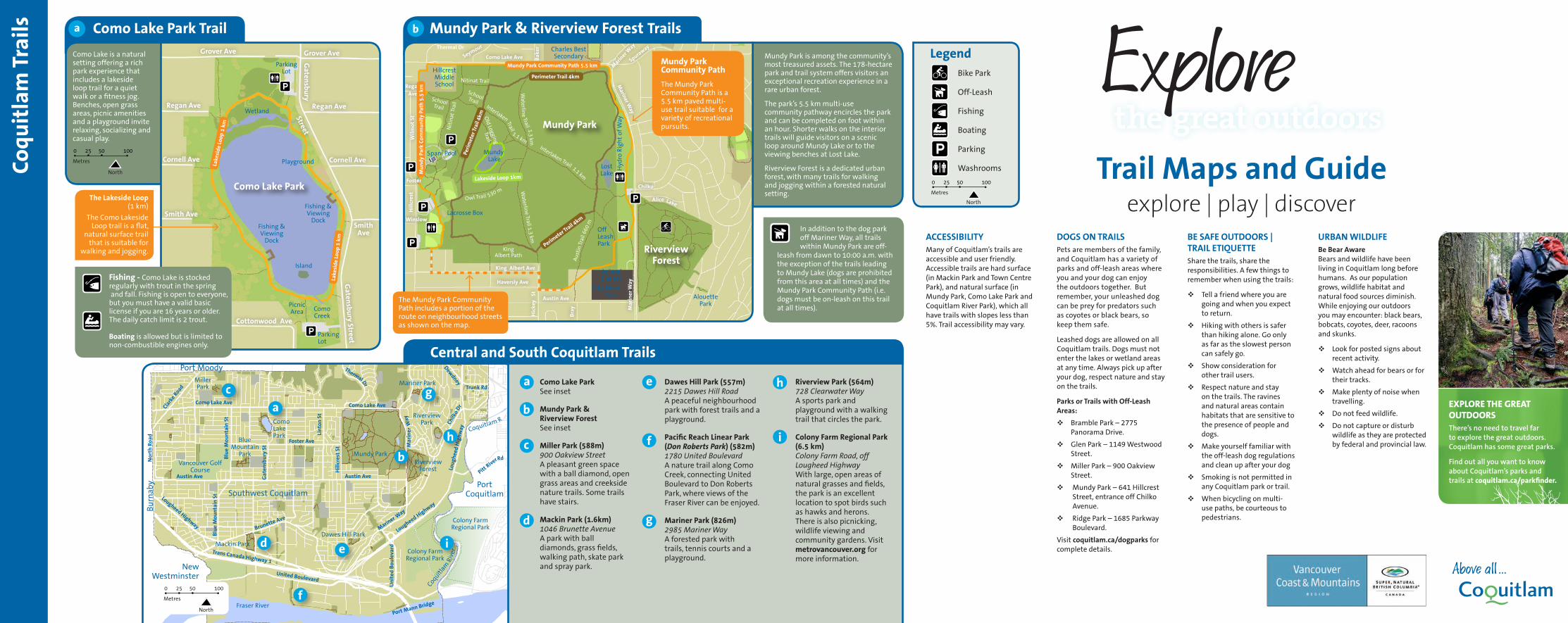
BE SAFE OUTDOORS | TRAIL ETIQUETTE Share the trails, share the responsibilities. A few things to remember when using the trails: Tell a friend where you are going and when you expect to return. Hiking with others is safer than hiking alone. Go only as far as the slowest person can safely go. Show consideration for other trail users. Respect nature and stay on the trails. The ravines and natural areas contain habitats that are sensitive to the presence of people and dogs. Make yourself familiar with the off-leash dog regulations and clean up after your dog Smoking is not permitted in any Coquitlam park or trail. When bicycling on multi- use paths, be courteous to pedestrians. URBAN WILDLIFE Be Bear Aware Bears and wildlife have been living in Coquitlam long before humans. As our population grows, wildlife habitat and natural food sources diminish. While enjoying our outdoors you may encounter: black bears, bobcats, coyotes, deer, racoons and skunks. Look for posted signs about recent activity. Watch ahead for bears or for their tracks. Make plenty of noise when travelling. Do not feed wildlife. Do not capture or disturb wildlife as they are protected by federal and provincial law. DOGS ON TRAILS Pets are members of the family, and Coquitlam has a variety of parks and off-leash areas where you and your dog can enjoy the outdoors together. But remember, your unleashed dog can be prey for predators such as coyotes or black bears, so keep them safe. Leashed dogs are allowed on all Coquitlam trails. Dogs must not enter the lakes or wetland areas at any time. Always pick up after your dog, respect nature and stay on the trails. Parks or Trails with Off-Leash Areas: Bramble Park – 2775 Panorama Drive. Glen Park – 1149 Westwood Street. Miller Park – 900 Oakview Street. Mundy Park – 641 Hillcrest Street, entrance off Chilko Avenue. Ridge Park – 1685 Parkway Boulevard. Visit coquitlam.ca/dogparks for complete details. ACCESSIBILITY Many of Coquitlam’s trails are accessible and user friendly. Accessible trails are hard surface (in Mackin Park and Town Centre Park), and natural surface (in Mundy Park, Como Lake Park and Coquitlam River Park), which all have trails with slopes less than 5%. Trail accessibility may vary. Trail Maps and Guide explore | play | discover EXPLORE THE GREAT OUTDOORS There’s no need to travel far to explore the great outdoors. Coquitlam has some great parks. Find out all you want to know about Coquitlam’s parks and trails at coquitlam.ca/parkfinder. Mundy Park & Riverview Forest Trails Como Lake Park Trail Coquitlam Trails Smith Ave Regan Ave Gatensbury Street Grover Ave Grover Ave Cornell Ave Regan Ave Cornell Ave Milford Ave Cottonwood Ave Smith Ave Gatensbury Street Mariner Way Spuraway Baker Como Lake Ave Thermal Dr Seymour Winslow Foster Regan Ave Hillcrest Wilmot St Mariner Way King Albert Ave Bray Haversly Ave Austin Ave Mariner Way Hickey St Chilko Alice Lake Lougheed Highway Dewdney Trunk Rd Chilko Dr Lougheed Highway Mariner Way United Boulevard Port Mann Bridge Trans Canada Highway 1 United Boulevard Lougheed Highway North Road Brunette Ave Austin Ave Blue Mountain St Pitt River Mariner Way Foster Ave Hillcrest St Linton St Como Lake Ave Rd Thermal Dr Como Lake Ave Blue Mountain St Clarke Road Gatensbury St Parking Lot Wetland Playground Como Lake Park Fishing & Viewing Dock Fishing & Viewing Dock Island Parking Lot Como Creek Picnic Area Lakeside Loop 1 km Lakeside Loop 1 km Charles Best Secondary Perimeter Trail 4km Mundy Park Community Path 5.5 km Hillcrest Middle School Mundy Park Community Path 5.5 km Lost Lake Hydro Right of Way City Works Yard Animal Shelter Off Leash Park Interlaken Trail 1.1 km 660 m Waterline Trail 1.3 km Austin Trail 530 m Owl Trail King Albert Path Lacrosse Box Mundy Park Interlaken Trail Trail 1.1 km Waterline 1.3 km Old Logging Trail School Trail School Trail Nitinat Trail Nitinat Trail Spani Pool Mundy Lake Perimeter Trail 4km Lakeside Loop 1km Perimeter Trail 4km Riverview Forest Alouette Park Port Moody Mariner Park Riverview Park R Coquitlam Port Coquitlam Colony Farm Regional Park Colony Farm Regional Park Coquitlam River Fraser River Mackin Park New Westminster Burnaby Vancouver Golf Course Southwest Coquitlam Dawes Hill Park Austin Ave Riverview Forest Mundy Park Blue Mountain Park Como Lake Park Miller Park Como Lake Park See inset Mundy Park & Riverview Forest See inset Miller Park (588m) 900 Oakview Street A pleasant green space with a ball diamond, open grass areas and creekside nature trails. Some trails have stairs. Mackin Park (1.6km) 1046 Brunette Avenue A park with ball diamonds, grass fields, walking path, skate park and spray park. Dawes Hill Park (557m) 2215 Dawes Hill Road A peaceful neighbourhood park with forest trails and a playground. Pacific Reach Linear Park (Don Roberts Park) (582m) 1780 United Boulevard A nature trail along Como Creek, connecting United Boulevard to Don Roberts Park, where views of the Fraser River can be enjoyed. Mariner Park (826m) 2985 Mariner Way A forested park with trails, tennis courts and a playground. Riverview Park (564m) 728 Clearwater Way A sports park and playground with a walking trail that circles the park. Colony Farm Regional Park (6.5 km) Colony Farm Road, off Lougheed Highway With large, open areas of natural grasses and fields, the park is an excellent location to spot birds such as hawks and herons. There is also picnicking, wildlife viewing and community gardens. Visit metrovancouver.org for more information. Mundy Park Community Path The Mundy Park Community Path is a 5.5 km paved multi- use trail suitable for a variety of recreational pursuits. The Mundy Park Community Path includes a portion of the route on neighbourhood streets as shown on the map. Fishing - Como Lake is stocked regularly with trout in the spring and fall. Fishing is open to everyone, but you must have a valid basic license if you are 16 years or older. The daily catch limit is 2 trout. Boating is allowed but is limited to non-combustible engines only. The Lakeside Loop (1 km) The Como Lakeside Loop trail is a flat, natural surface trail that is suitable for walking and jogging. Mundy Park is among the community’s most treasured assets. The 178-hectare park and trail system offers visitors an exceptional recreation experience in a rare urban forest. The park’s 5.5 km multi-use community pathway encircles the park and can be completed on foot within an hour. Shorter walks on the interior trails will guide visitors on a scenic loop around Mundy Lake or to the viewing benches at Lost Lake. Riverview Forest is a dedicated urban forest, with many trails for walking and jogging within a forested natural setting. Como Lake is a natural setting offering a rich park experience that includes a lakeside loop trail for a quiet walk or a fitness jog. Benches, open grass areas, picnic amenities and a playground invite relaxing, socializing and casual play. Central and South Coquitlam Trails In addition to the dog park off Mariner Way, all trails within Mundy Park are off- leash from dawn to 10:00 a.m. with the exception of the trails leading to Mundy Lake (dogs are prohibited from this area at all times) and the Mundy Park Community Path (i.e. dogs must be on-leash on this trail at all times). 0 25 North Metres 50 100 0 25 North Metres 50 100 Parking Off-Leash Fishing Boating Washrooms Legend 0 25 North Metres 50 100 Bike Park