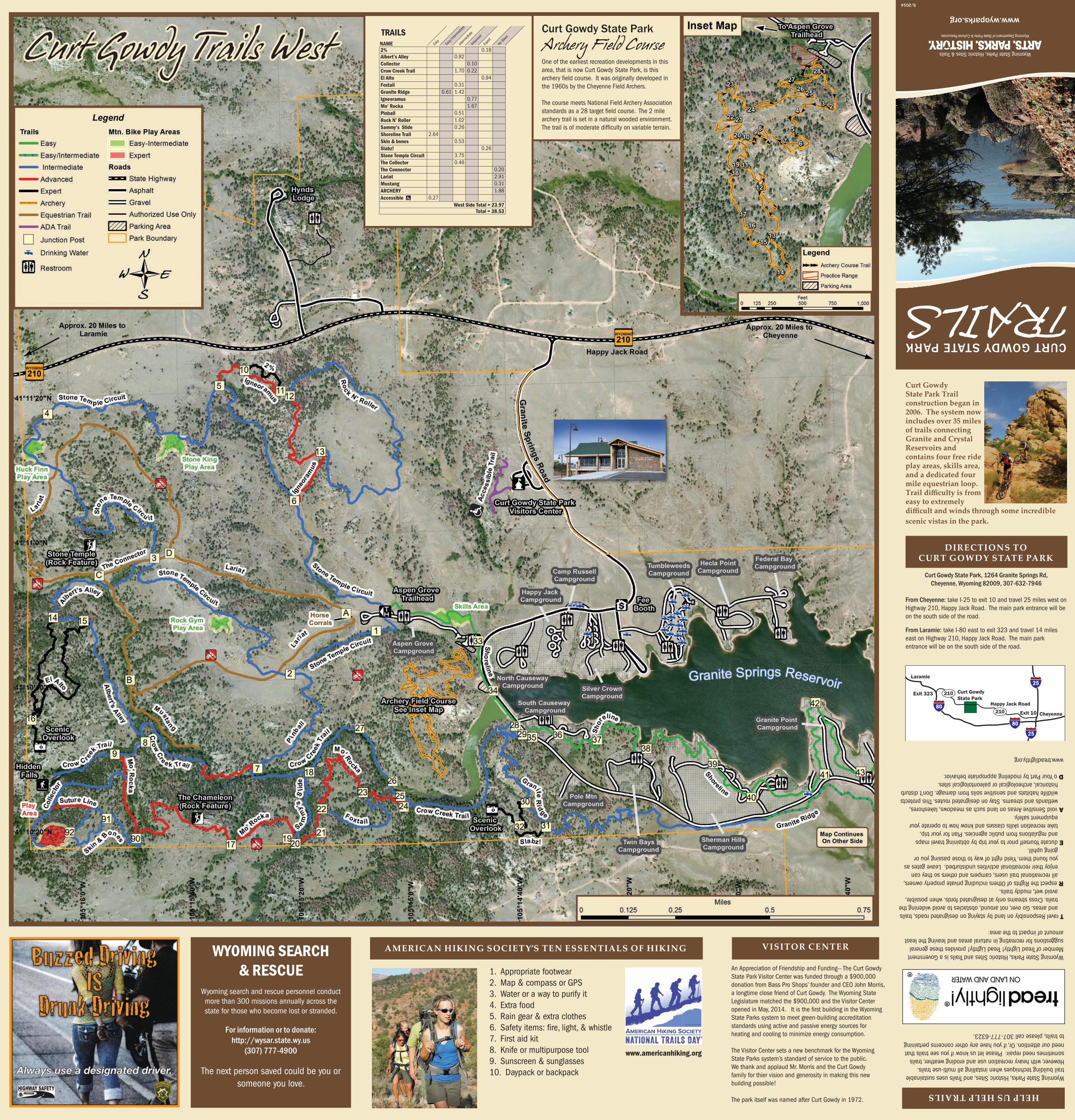
CURT GOWDY STATE PARK TRAILS Wyoming State Parks, Historic Sites & Trails Curt Gowdy State Park Trail construction began in 2006. The system now includes over 35 miles of trails connecting Granite and Crystal Reservoirs and contains four free ride play areas, skills area, and a dedicated four mile equestrian loop. Trail difficulty is from easy to extremely WYOMING SEARCH & RESCUE Wyoming search and rescue personnel conduct more than 300 missions annually across the state for those who become lost or stranded. For information or to donate: http://wysar.state.wy.us (307) 777-4900 The next person saved could be you or someone you love. www.wyoparks.org difficult and winds through some incredible scenic vistas in the park. DIRECTIONS TO CURT GOWDY STATE PARK Curt Gowdy State Park, 1264 Granite Springs Rd, Cheyenne, Wyoming 82009, 307-632-7946 From Cheyenne: take I-25 to exit 10 and travel 25 miles west on Highway 210, Happy Jack Road. The main park entrance will be on the south side of the road. From Laramie: take I-80 east to exit 323 and travel 14 miles east on Highway 210, Happy Jack Road. The main park entrance will be on the south side of the road. AMERICAN HIKING SOCIETY’S TEN ESSENTIALS OF HIKING 5/2014 1. Appropriate footwear 2. Map & compass or GPS 3. Water or a way to purify it 4. Extra food 5. Rain gear & extra clothes 6. Safety items: fire, light, & whistle 7. First aid kit 8. Knife or multipurpose tool 9. Sunscreen & sunglasses 10. Daypack or backpack www.americanhiking.org Cheyenne Laramie Curt Gowdy State Park Happy Jack Road Exit 323 Exit 10 80 80 25 25 210 210 HELP US HELP TRAILS Wyoming State Parks, Historic Sites, and Trails uses sustainable trail building techniques when installing all multi-use trails. However, with heavy recreation use and eroding weather, trails sometimes need repair. Please let us know if you see trails that need our attention. Or, if you have any other concerns pertaining to trails, please call 307-777-6323. Wyoming State Parks, Historic Sites and Trails is a Government Member of Tread Lightly! Tread Lightly! provides these general suggestions for recreating in natural areas and leaving the least amount of impact to the area: T ravel Responsibly on land by staying on designated roads, trails and areas. Go over, not around, obstacles to avoid widening the trails. Cross streams only at designated fords. when possible, avoid wet, muddy trails. R espect the Rights of Others including private property owners, all recreational trail users, campers and others so they can enjoy their recreational activities undisturbed. Leave gates as you found them. Yield right of way to those passing you or going uphill. E ducate Yourself prior to your trip by obtaining travel maps and regulations from public agencies. Plan for your trip, take recreation skills classes and know how to operate your equipment safely. A void Sensitive Areas on land such as meadows, lakeshores, wetlands and streams. Stay on designated routes. This protects wildlife habitats and sensitive soils from damage. Don’t disturb historical, archeological or paleontological sites. D o Your Part by modeling appropriate behavior. www.treadlightly.org Curt Gowdy State Park Archery Field Course One of the earliest recreation developments in this area, that is now Curt Gowdy State Park, is this archery field course. It was originally developed in the 1960s by the Cheyenne Field Archers. The course meets National Field Archery Association standards as a 28 target field course. The 2 mile archery trail is set in a natural wooded environment. The trail is of moderate difficulty on variable terrain. Curt Gowdy Trails West An Appreciation of Friendship and Funding-- The Curt Gowdy State Park Visitor Center was funded through a $900,000 donation from Bass Pro Shops’ founder and CEO John Morris, a longtime close friend of Curt Gowdy. The Wyoming State Legislature matched the $900,000 and the Visitor Center opened in May, 2014. It is the first building in the Wyoming State Parks system to meet green-building accreditation standards using active and passive energy sources for heating and cooling to minimize energy consumption. The Visitor Center sets a new benchmark for the Wyoming State Parks system’s standard of service to the public. We thank and applaud Mr. Morris and the Curt Gowdy family for thier vision and generosity in making this new building possible! The park itself was named after Curt Gowdy in 1972. VISITOR CENTER NAME 2% 0.18 Albert’s Alley 0.92 Collector 0.10 Crow Creek Trail 1.70 0.22 El Alto 0.94 Foxtail 0.31 Granite Ridge 0.61 1.42 Igneoramus 0.77 Mo’ Rocka 1.67 Pinball 0.51 Rock N’ Roller 1.02 Sammy’s Slide 0.26 Shoreline Trail 2.64 Skin & bones 0.53 Slabz! 0.26 Stone Temple Circuit 3.75 The Collector 0.46 The Connector 0.20 Lariat 2.91 Mustang 0.31 ARCHERY 1.88 Accessible 0.27 West Side Total = 23.97 Total = 38.53 Easy Easy/Intermediate Intermediate Advanced Expert TRAILS No Bikes
Transcript
CURT GOWDY STATE PARK
TRAILS
Wyoming State Parks, Historic Sites & Trails
Curt Gowdy State Park Trail construction began in 2006. The system now includes over 35 miles of trails connecting Granite and Crystal Reservoirs and contains four free ride play areas, skills area, and a dedicated four mile equestrian loop. Trail difficulty is from easy to extremely
WYOMING SEARCH & RESCUE
Wyoming search and rescue personnel conduct more than 300 missions annually across the state for those who become lost or stranded.
For information or to donate:http://wysar.state.wy.us
(307) 777-4900
The next person saved could be you or someone you love.
www.wyoparks.org
difficult and winds through some incredible scenic vistas in the park.
DIRECTIONS TO CURT GOWDY STATE PARK
Curt Gowdy State Park, 1264 Granite Springs Rd, Cheyenne, Wyoming 82009, 307-632-7946
From Cheyenne: take I-25 to exit 10 and travel 25 miles west on Highway 210, Happy Jack Road. The main park entrance will be on the south side of the road. From Laramie: take I-80 east to exit 323 and travel 14 miles east on Highway 210, Happy Jack Road. The main park entrance will be on the south side of the road.
AMERICAN HIKING SOCIETY’S TEN ESSENTIALS OF HIKING
5/2014
1. Appropriate footwear2. Map & compass or GPS3. Water or a way to purify it4. Extra food5. Rain gear & extra clothes6. Safetyitems:fire,light,&whistle7. First aid kit8. Knife or multipurpose tool9. Sunscreen & sunglasses10. Daypack or backpack
www.americanhiking.org
Cheyenne
Laramie
Curt GowdyState Park
Happy Jack Road
Exit 323
Exit 1080
80
25
25
210
210
HELP US HELP TRAILS
Wyoming State Parks, Historic Sites, and Trails uses sustainable trail building techniques when installing all multi-use trails. However, with heavy recreation use and eroding weather, trails sometimes need repair. Please let us know if you see trails that need our attention. Or, if you have any other concerns pertaining to trails, please call 307-777-6323.
Wyoming State Parks, Historic Sites and Trails is a Government Member of Tread Lightly! Tread Lightly! provides these general suggestions for recreating in natural areas and leaving the least amount of impact to the area:
T ravel Responsibly on land by staying on designated roads, trails and areas. Go over, not around, obstacles to avoid widening the trails. Cross streams only at designated fords. when possible, avoid wet, muddy trails.
R espect the Rights of Others including private property owners, all recreational trail users, campers and others so they can enjoy their recreational activities undisturbed. Leave gates as you found them. Yield right of way to those passing you or going uphill.
E ducate Yourself prior to your trip by obtaining travel maps and regulations from public agencies. Plan for your trip, take recreation skills classes and know how to operate your equipment safely.
A void Sensitive Areas on land such as meadows, lakeshores, wetlands and streams. Stay on designated routes. This protects wildlife habitats and sensitive soils from damage. Don’t disturb historical, archeological or paleontological sites.
D o Your Part by modeling appropriate behavior.
www.treadlightly.org
Curt Gowdy State ParkArchery Field CourseOne of the earliest recreation developments in this area, that is now Curt Gowdy State Park, is this archeryfieldcourse.Itwasoriginallydevelopedinthe 1960s by the Cheyenne Field Archers.
The course meets National Field Archery Association standardsasa28targetfieldcourse.The2milearchery trail is set in a natural wooded environment. Thetrailisofmoderatedifficultyonvariableterrain.
Curt Gowdy Trails West
An Appreciation of Friendship and Funding-- The Curt Gowdy State Park Visitor Center was funded through a $900,000 donation from Bass Pro Shops’ founder and CEO John Morris, a longtime close friend of Curt Gowdy. The Wyoming State Legislature matched the $900,000 and the Visitor Center openedinMay,2014.ItisthefirstbuildingintheWyomingState Parks system to meet green-building accreditation standards using active and passive energy sources for heating and cooling to minimize energy consumption. The Visitor Center sets a new benchmark for the Wyoming State Parks system’s standard of service to the public. We thank and applaud Mr. Morris and the Curt Gowdy family for thier vision and generosity in making this new building possible!
The park itself was named after Curt Gowdy in 1972.
With over 8,500 miles of trails, you’re sure to find a perfect fit
ABOUT CURT GOWDY STATE PARK
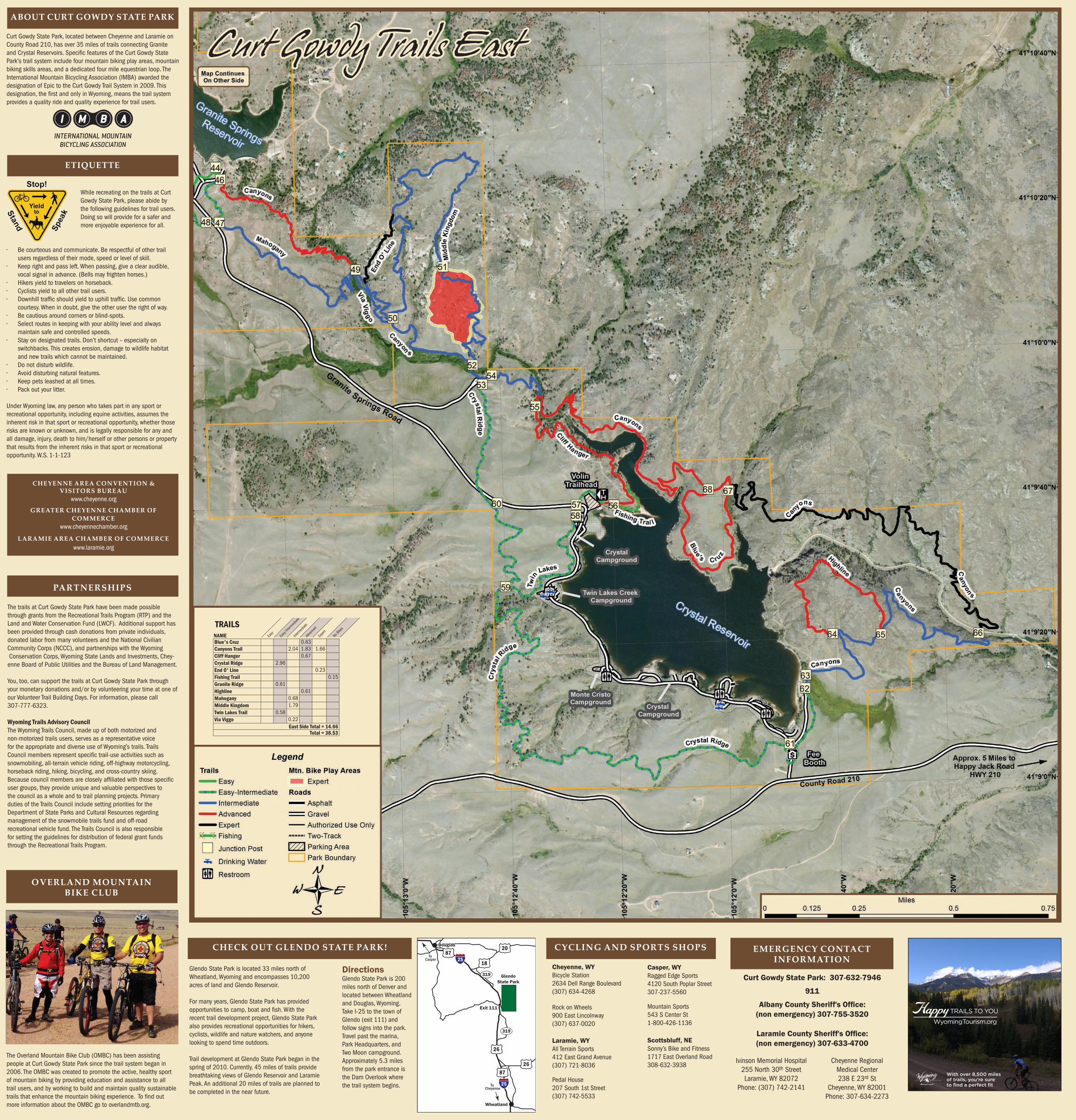
Curt Gowdy State Park, located between Cheyenne and Laramie on County Road 210, has over 35 miles of trails connecting Granite andCrystalReservoirs.SpecificfeaturesoftheCurtGowdyStatePark's trail system include four mountain biking play areas, mountain biking skills areas, and a dedicated four mile equestrian loop. The International Mountain Bicycling Association (IMBA) awarded the designation of Epic to the Curt Gowdy Trail System in 2009. This designation,thefirstandonlyinWyoming,meansthetrailsystemprovides a quality ride and quality experience for trail users.
While recreating on the trails at Curt Gowdy State Park, please abide by the following guidelines for trail users. Doing so will provide for a safer and more enjoyable experience for all.
• Be courteous and communicate. Be respectful of other trail users regardless of their mode, speed or level of skill.
• Keep right and pass left. When passing, give a clear audible, vocal signal in advance. (Bells may frighten horses.)
• Hikers yield to travelers on horseback.• Cyclists yield to all other trail users.• Downhilltrafficshouldyieldtouphilltraffic.Usecommon
courtesy. When in doubt, give the other user the right of way.• Be cautious around corners or blind-spots. • Select routes in keeping with your ability level and always
maintain safe and controlled speeds. • Stay on designated trails. Don’t shortcut – especially on
switchbacks. This creates erosion, damage to wildlife habitat and new trails which cannot be maintained.
• Do not disturb wildlife.• Avoid disturbing natural features. • Keep pets leashed at all times.• Pack out your litter.
UnderWyominglaw,anypersonwhotakespartinanysportorrecreational opportunity, including equine activities, assumes the inherent risk in that sport or recreational opportunity, whether those risks are known or unknown, and is legally responsible for any and all damage, injury, death to him/herself or other persons or property that results from the inherent risks in that sport or recreational opportunity. W.S. 1-1-123
PARTNERSHIPS
The trails at Curt Gowdy State Park have been made possible through grants from the Recreational Trails Program (RTP) and the Land and Water Conservation Fund (LWCF). Additional support has been provided through cash donations from private individuals, donated labor from many volunteers and the National Civilian Community Corps (NCCC), and partnerships with the Wyoming Conservation Corps, Wyoming State Lands and Investments, Chey-enneBoardofPublicUtilitiesandtheBureauofLandManagement.
You, too, can support the trails at Curt Gowdy State Park through your monetary donations and/or by volunteering your time at one of our Volunteer Trail Building Days. For information, please call 307-777-6323.
Wyoming Trails Advisory CouncilThe Wyoming Trails Council, made up of both motorized and non-motorized trails users, serves as a representative voice for the appropriate and diverse use of Wyoming’s trails. Trails Councilmembersrepresentspecifictrail-useactivitiessuchassnowmobiling, all-terrain vehicle riding, off-highway motorcycling, horseback riding, hiking, bicycling, and cross-country skiing. Becausecouncilmembersarecloselyaffiliatedwiththosespecificuser groups, they provide unique and valuable perspectives to the council as a whole and to trail planning projects. Primary duties of the Trails Council include setting priorities for the Department of State Parks and Cultural Resources regarding management of the snowmobile trails fund and off-road recreational vehicle fund. The Trails Council is also responsible for setting the guidelines for distribution of federal grant funds through the Recreational Trails Program.
DirectionsGlendo State Park is 200 miles north of Denver and located between Wheatland and Douglas, Wyoming. Take I-25 to the town of Glendo (exit 111) and follow signs into the park. Travel past the marina, Park Headquarters, and Two Moon campground. Approximately 5.3 miles from the park entrance is the Dam Overlook where the trail system begins.
CHECK OUT GLENDO STATE PARK!
Glendo State Park is located 33 miles north of Wheatland, Wyoming and encompasses 10,200 acres of land and Glendo Reservoir.
For many years, Glendo State Park has provided opportunitiestocamp,boatandfish.Withtherecent trail development project, Glendo State Park also provides recreational opportunities for hikers, cyclists, wildlife and nature watchers, and anyone looking to spend time outdoors.
Trail development at Glendo State Park began in the spring of 2010. Currently, 45 miles of trails provide breathtaking views of Glendo Reservoir and Laramie Peak. An additional 20 miles of trails are planned to be completed in the near future.
Wheatland
25
25
2687
87
26
319
319
18
20DouglasDouglas
Exit 111
GlendoState Park
To Casper
To Cheyenne
CHEYENNE AREA CONVENTION & VISITORS BUREAU
www.cheyenne.org
GREATER CHEYENNE CHAMBER OF COMMERCE
www.cheyennechamber.org
LARAMIE AREA CHAMBER OF COMMERCEwww.laramie.org
OVERLAND MOUNTAIN BIKE CLUB
The Overland Mountain Bike Club (OMBC) has been assisting people at Curt Gowdy State Park since the trail system began in 2006. The OMBC was created to promote the active, healthy sport of mountain biking by providing education and assistance to all trail users, and by working to build and maintain quality sustainable trailsthatenhancethemountainbikingexperience.Tofindoutmore information about the OMBC go to overlandmtb.org.
ETIQUETTE
Curt Gowdy Trails East
EMERGENCY CONTACT INFORMATION
Curt Gowdy State Park: 307-632-7946
911
Albany County Sheriff's Office:(non emergency) 307-755-3520
Laramie County Sheriff's Office:(non emergency) 307-633-4700
Ivinson Memorial Hospital 255 North 30th Street Laramie, WY 82072
Phone: (307) 742-2141
Cheyenne Regional Medical Center238 E 23rd St
Cheyenne, WY 82001 Phone: 307-634-2273
NAME Blue's Cruz 0.63 Canyons Trail 2.04 1.83 1.66Cliff Hanger 0.67Crystal Ridge 2.96End O' Line 0.23Fishing Trail 0.15Granite Ridge 0.61Highline 0.61Mahogany 0.68Middle Kingdom 1.79Twin Lakes Trail 0.58Via Viggo 0.22
East Side Total = 14.66Total = 38.53
Easy
Easy/
Interm
ediat
e
Interm
ediat
e
Advan
ced
Expert
TRAILSNo B
ikes
CYCLING AND SPORTS SHOPS
Casper, WYRagged Edge Sports4120 South Poplar Street307-237-5560
Mountain Sports543 S Center St1-800-426-1136
Scottsbluff, NESonny’s Bike and Fitness1717 East Overland Road308-632-3938
Cheyenne, WYBicycle Station2634 Dell Range Boulevard (307) 634-4268
Rock on Wheels900 East Lincolnway (307) 637-0020
Laramie, WYAll Terrain Sports412 East Grand Avenue (307) 721-8036