46
District of Squamish Trails Standards Cover Photo Courtesy of Susan Thompson
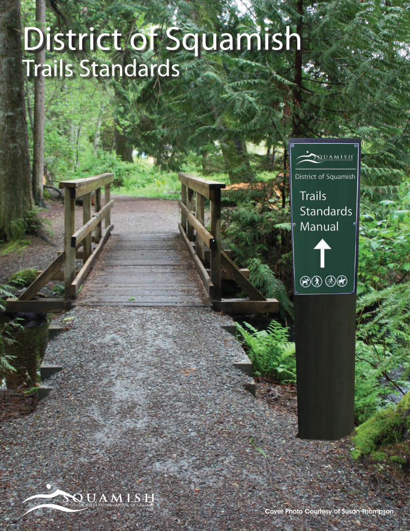
District of SquamishTrails Standards
Cover Photo Courtesy of Susan Thompson

TABLE OF CONTENTSContents
TABLE OF CONTENTS 3
INTRODUCTION
ACKNOWLEDGEMENT AND DEDICATION 1
INTENT AND OPERATING PRINCIPLES 2
INVENTORY AND MAPPING 3
MANAGEMENT
TRAIL CLASSIFICATION SYSTEM AND STANDARDS CHART 3
TRAIL MAINTENANCE AND INSPECTION STANDARDS 12
ACCESSIBILITY 12
CONSTRUCTION
TRAIL CONSTRUCTION STANDARDS AND GUIDELINES 13
MOUNTAIN BIKE TRAILS 16
EQUESTRIAN TRAILS STANDARDS 20
ENVIRONMENTAL REQUIREMENTS: 21
WORKING IN AND AROUND STREAMS 21
ENVIRONMENTAL STANDARDS AND GUIDELINES IN TRAIL DEVELOPMENT 22
TRAIL SIGNAGE STANDARDS GUIDELINES 27
USER INFORMATION
USER HARMONY 30
RESPECT BEAR HABITAT 30
CLIMBING 31
EQUESTRIAN 32
PEDESTRIAN 32
MOTORIZED BIKE 33
TRIALS RIDING 34
MOUNTAIN BIKE 35
SPECIAL EVENT ACCESS/APPROVAL TO USE TRAILS 36
APPENDIX
TRAILS INSPECTION CHECK LIST 37
RESOURCES 39
REFERENCES 41
TABLE O
F CO
NTEN
TS

This document could not have been achieved without the invaluable input and collaboration from the original Trails Standards Working Group. The volunteer members of the committee included: Bob Brant, Vince Hoog, John Howe, Chris McCrum, Cliff Miller, Neil Plumb, and Brad Walkey. There were also a large number of individuals and staff who, from time to time, have contributed to various sections of the Trail Standards Manual. The Squamish Trails Society (STS), Squamish Dirt Bike Association (SDBA), and the Squamish Off-Road Cycling Association (SORCA) have supported and nurtured this long process and provided their knowledge and expertise to its development.
This document is dedicated to the memory of Councillor Ray Peters. Ray Peters was the Council representative on the Working Group. His passion and commitment to his community and his beloved trails both inspired and led the working group. It was Ray’s vision to see the District play a lead role in the future of our extensive trail system and to continue to develop Squamish as the “Outdoor Recreation Capital of Canada”.
ACKNOWLEDGEMENT AND DEDICATION
We also acknowledge the many great resources drawn upon in creating this document, including:
• Corridor Recreational Trail Management Plan
• Trails Strategy for British Columbia
• Squamish Mountain Bike Management Plan
• Sea to Sky Corridor Recreation Strategy
• Whistler Trail Standards: Environmental and Technical Trail Features
• Trail Solutions: IMBA’s Guide to Building Sweet Singletrack
1
INTRO
DUC
TION
INTENT AND OPERATING PRINCIPLESThe intent of this document is to provide consistent guidelines and standards for trail development and maintenance for the District of Squamish and other potential trail builders in the community. All new trail development will be built and maintained to these standards. Existing trails will be “grand-fathered” and upgraded to these standards as time and resources permit.
Effective “Trail Standards” provide a strong foundation for good trail design, construction, and maintenance and will provide a safe and enjoyable experience for users. A successful trail system is dependent on the cooperation, communication and courtesy of the users, builders, and the landowners. The underlining philosophy of this document is that all public access trails are a “shared resource and a shared use” and as such no public trails are of exclusive use. Different courtesies and “rights of the road” may apply depending on the primary use of the trail.
These guidelines and standards are applicable within municipal boundaries and as supported by the landowner, which may include the District of Squamish, private landowners, and public agencies, such as the Ministry of Tourism, Culture and the Arts and the Ministry of Forests and Range. Outside of District boundaries, the Squamish/Lillooet Regional District Trails Coordinator should be consulted along with the Sea to Sky Corridor Recreation Trail Steering Committee on trails issues.
As user volumes, physical environments, and trail usage may change with time, a periodic review of these guidelines and standards by the District of Squamish will be done to keep them effective and relevant.
The District of Squamish should be contacted about any enquires or clarifications of these standards. There are many stakeholders who need to be part of the process of developing and maintaining trails. It is important to engage the District of Squamish in the planning stages of trail projects and to consult with all stakeholders in the development process.
For safety and maintenance reasons, there is limited access to trails for motorized vehicles with the exception of maintenance/service vehicles and battery-powered wheelchairs and carts. Other motorized vehicles may be operated only on “specified” trails within certain areas and warning signs to the area must be posted at all access points. In the future there may be new “designated” areas that are developed and maintained by local motorbike clubs (ex: SDBA).
2
INTR
OD
UCTIO
N
3
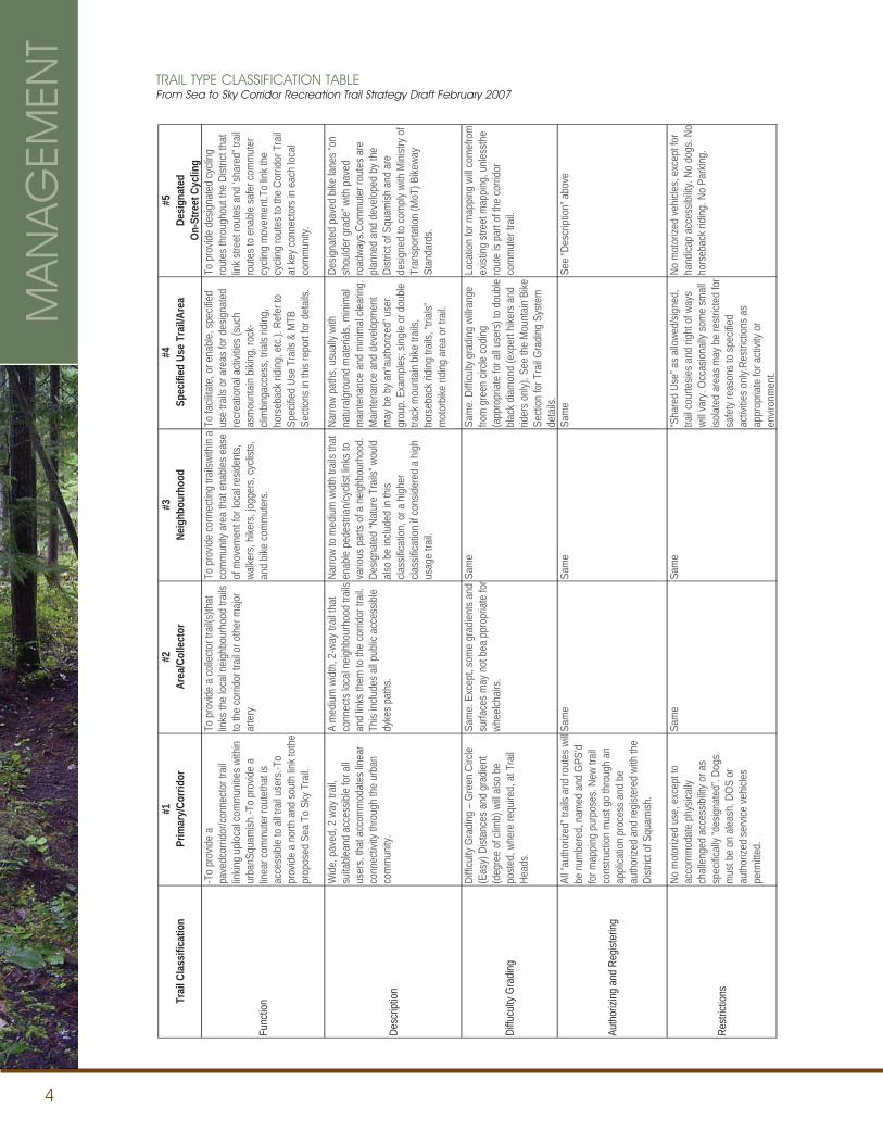
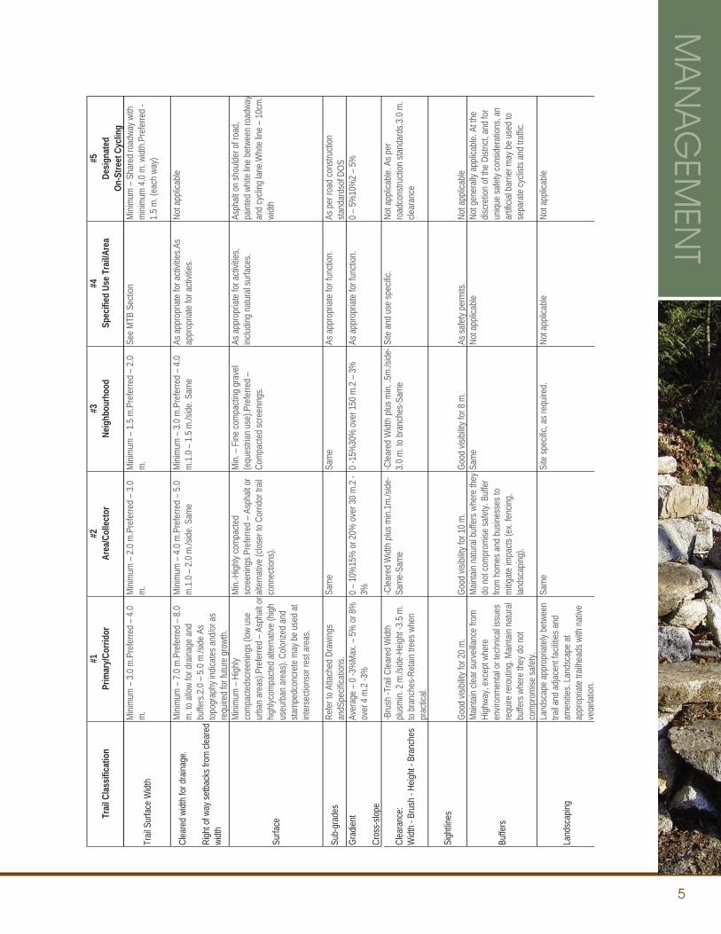
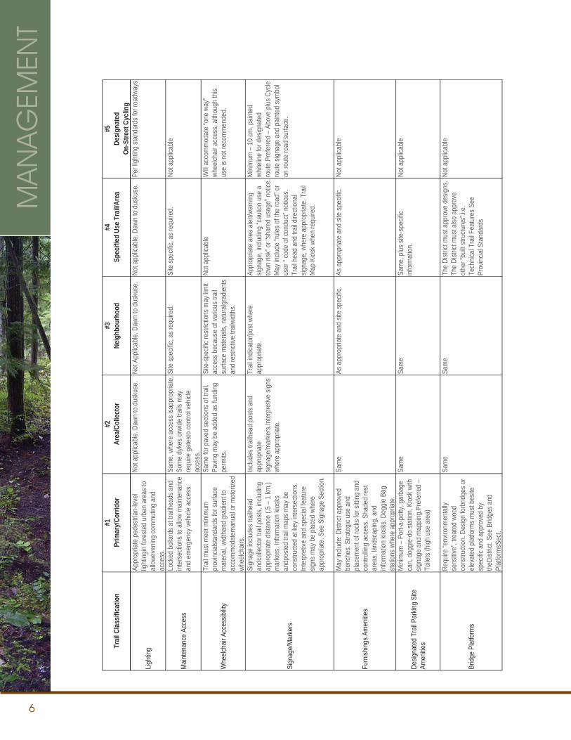
TRAIL CLASSIFICATION SYSTEM AND STANDARDS CHART
The trail classification charts on the following pages divide the trail system into five types or classifications of trails. The function and description define each classification, and the left side column provides detail on specific aspects of the trail.
Further to this Trail Classification system, The Sea to Sky Corridor Recreational Trail Strategy Draft, February 2007, from the Provincial Government, breaks downs the Trail Classification into Roman Numerals I-V. (#1 is also a Type I, #2 & #3 could be a Type I or II whereas #4 ranges from II-V) For further clarification see the Mountain Bike Section on Page 18.
NEW TRAIL DEVELOPMENT APPLICATION PROCESSAll new trails must be approved through an application process. This process will be managed by the District of Squamish, through the Trails Coordinator, in cooperation with local trails user groups. If the trail falls on Crown Land, the Provincial Standards set out in the Sea to Sky Corridor Recreation Trail Strategy must be followed. The appropriate landowners must be contacted and provide written approval before making an application for trail construction. An application form and a Trail Plan must be submitted for approval. The location and route must be flagged, GPS’d, and inspected prior to any approvals or development. All safety and security issues must be addressed in the Trail Plan, including any technical trail features (TTF’S) to be added.
Once approval has been given, the trail will be re-inspected and any outstanding issues will be addressed. The trail will be classified, named, GPS mapped, and added to the trail inventory.
TRAIL NUMBERING AND MAPPING SYSTEMAll “authorized” trails will be classified, numbered, named and mapped using a GPS system for mapping and signage purposes. The intent of this requirement is to have a consistent and accurate system that works for all user groups and enables trail maps to be coded, indexed and consistently named.
INVENTORY AND MAPPING
ESTABLISHED TRAILSSection 56 of the Forest and Range Practice Act allows the minister to order the establishment of a recreation trail on Crown Land. These ‘established trails’ are legal trails that must be given consideration during land-use planning decisions. Infrastructure development, maintenance, and resources will be invested on these trails. A higher level of preservation applies to these trails; however, establishment of a trail does not guarantee conservation in the same sense as a Provincial Park or Protected Area. Section 56 also allows the minister to order the disestablishment of a recreation trail on Crown Land.
If a land-use decision may impact an ‘established trail’, local communities, trail clubs, and users will be consulted. A wide-spectrum of trail impact mitigations (TIMs) may be used, dependent upon the significance of the trail and its amount of use. An example of TIM’s may be a forested buffer along the trail or the trail may be relocated or re-established after harvesting or other industrial activity.
Section 57 Forest and Range Practice Act states no recreation trails may be constructed on Crown Land unless authorized by the minister. The minister may authorize the construction, rehabilitation, or maintenance of recreation trail on Crown Land and may impose conditions that must be met. These trails are not established as in section 56 and are therefore not protected. The minister may revoke authorization.
For more information about ‘established’, ‘authorized’, and ‘unauthorized’ trails, and information about applying for authorization, please see page 16.
MA
NA
GEM
ENT
4
TRAIL TYPE CLASSIFICATION TABLEFrom Sea to Sky Corridor Recreation Trail Strategy Draft February 2007
MA
NA
GEM
ENT
Trai
l Cla
ssifi
catio
n#1
Prim
ary/
Corri
dor
#2Ar
ea/C
olle
ctor
#3Ne
ighb
ourh
ood
#4Sp
ecifi
ed U
se T
rail/
Area
#5De
sign
ated
On-S
treet
Cyc
ling
Func
tion
-To
prov
ide a
pa
vedc
orrid
or/co
nnec
tor t
rail
linkin
g up
local
com
mun
ities w
ithin
urba
nSqu
amish
.-To
prov
ide a
lin
ear c
omm
uter
rout
etha
t is
acce
ssibl
e to
all t
rail u
sers
.-To
prov
ide a
nor
th a
nd so
uth
link t
othe
pr
opos
ed S
ea T
o Sk
y Tra
il.
To p
rovid
e a
colle
ctor t
rail(s
)that
lin
ks th
e loc
al ne
ighbo
urho
od tr
ails
to th
e co
rrido
r tra
il or o
ther
majo
r ar
tery
.
To p
rovid
e co
nnec
ting
trails
with
in a
com
mun
ity a
rea
that
ena
bles e
ase
of m
ovem
ent f
or lo
cal r
eside
nts,
walke
rs, h
ikers
, jogg
ers,
cycli
sts,
and
bike
com
mut
ers.
To fa
cilita
te, o
r ena
ble, s
pecif
ied
use
trails
or a
reas
for d
esign
ated
re
crea
tiona
l acti
vities
(suc
h as
mou
ntain
biki
ng, r
ock-
clim
binga
cces
s, tri
als ri
ding,
ho
rseb
ack r
iding
, etc.
). Re
fer t
o Sp
ecifie
d Us
e Tr
ails &
MTB
Se
ction
s in
this
repo
rt fo
r det
ails.
To p
rovid
e de
signa
ted
cycli
ng
rout
es th
roug
hout
the
Distr
ict th
at
link s
treet
rout
es a
nd ‘s
hare
d” tr
ail
rout
es to
ena
ble sa
fer c
omm
uter
cy
cling
mov
emen
t.To
link t
he
cycli
ng ro
utes
to th
e Co
rrido
r Tra
il at
key c
onne
ctors
in e
ach
local
com
mun
ity.
Desc
riptio
n
Wide
, pav
ed, 2
way
trail
, su
itable
and
acce
ssibl
e fo
r all
user
s, th
at a
ccom
mod
ates
linea
r co
nnec
tivity
thro
ugh
the
urba
n co
mm
unity
.
A m
edium
widt
h, 2
-way
trail
that
co
nnec
ts loc
al ne
ighbo
urho
od tr
ails
and
links
them
to th
e co
rrido
r tra
il. Th
is inc
ludes
all p
ublic
acc
essib
le dy
kes p
aths
.
Narro
w to
med
ium w
idth
trails
that
en
able
pede
strian
/cycli
st lin
ks to
va
rious
par
ts of
a n
eighb
ourh
ood.
De
signa
ted
“Nat
ure
Trail
s” w
ould
also
be in
clude
d in
this
class
ificat
ion, o
r a h
igher
cla
ssific
ation
if co
nside
red
a hig
h us
age
trail.
Narro
w pa
ths,
usua
lly w
ith
natu
ralgr
ound
mat
erial
s, m
inim
al m
ainte
nanc
e an
d m
inim
al cle
aring
. M
ainte
nanc
e an
d de
velop
men
t m
ay b
e by
an“
auth
orize
d” u
ser
grou
p. E
xam
ples;
single
or d
ouble
tra
ck m
ount
ain b
ike tr
ails,
hors
ebac
k ridi
ng tr
ails,
“trial
s”
mot
orbik
e rid
ing a
rea
or tr
ail.
Desig
nate
d pa
ved
bike
lanes
“on
shou
lder g
rade
” with
pav
ed
road
ways
.Com
mut
er ro
utes
are
pla
nned
and
dev
elope
d by
the
Distr
ict o
f Squ
amish
and
are
de
signe
d to
com
ply w
ith M
inistr
y of
Tran
spor
tatio
n (M
oT) B
ikewa
y St
anda
rds.
Diffu
culty
Gra
ding
Diffic
ulty G
radin
g –
Gree
n Ci
rcle
(Eas
y) D
istan
ces a
nd g
radie
nt
(deg
ree
of cl
imb)
will
also
be
poste
d, w
here
requ
ired,
at T
rail
Head
s.
Sam
e. E
xcep
t, so
me
grad
ients
and
surfa
ces m
ay n
ot b
ea p
prop
riate
for
whee
lchair
s.
Sam
e Sa
me.
Diffi
culty
gra
ding
willra
nge
from
gre
en ci
rcle
codin
g (a
ppro
priat
e fo
r all u
sers
) to
doub
le bla
ck d
iamon
d (e
xper
t hike
rs a
nd
rider
s only
). Se
e th
e M
ount
ain B
ike
Secti
on fo
r Tra
il Gra
ding
Syste
m
deta
ils.
Loca
tion
for m
appin
g wi
ll com
efro
m
exist
ing st
reet
map
ping,
unle
ssth
e ro
ute
is pa
rt of
the
corri
dor
com
mut
er tr
ail.
Auth
orizi
ng a
nd R
egist
ering
All “
auth
orize
d” tr
ails a
nd ro
utes
will
be n
umbe
red,
nam
ed a
nd G
PS’d
for m
appin
g pu
rpos
es. N
ew tr
ail
cons
tructi
on m
ust g
o th
roug
h an
ap
plica
tion
proc
ess a
nd b
e au
thor
ized
and
regis
tere
d wi
th th
e Di
strict
of S
quam
ish.
Sam
e Sa
me
Sam
eSe
e “D
escr
iption
” abo
ve
Restr
iction
s
No m
otor
ized
use,
exc
ept t
o ac
com
mod
ate
phys
ically
ch
allen
ged
acce
ssibi
lity o
r as
spec
ificall
y “de
signa
ted”
. Dog
s m
ust b
e on
alea
sh. D
OS o
r au
thor
ized
serv
ice ve
hicles
pe
rmitte
d.
Sam
e Sa
me
“Sha
red
Use”
as a
llowe
d/sig
ned,
tra
il cou
rtesie
s and
righ
t of w
ays
will v
ary.
Occa
siona
lly so
me
small
iso
lated
are
as m
ay b
e re
strict
ed fo
r sa
fety
reas
ons t
o sp
ecifie
d ac
tivitie
s only
.Res
tricti
ons a
s ap
prop
riate
for a
ctivit
y or
envir
onm
ent.
No m
otor
ized
vehic
les, e
xcep
t for
ha
ndica
p ac
cess
ibility
. No
dogs
. No
hors
ebac
k ridi
ng. N
o Pa
rking
.
5
MA
NA
GEM
ENT
Trail
Clas
sifica
tion
#1Pr
imar
y/Cor
ridor
#2Ar
ea/C
ollec
tor
#3Ne
ighb
ourh
ood
#4Sp
ecifi
ed U
se T
rail/A
rea
#5De
signa
ted
On-S
treet
Cyc
ling
Trail
Sur
face
Widt
h
Mini
mum
– 3
.0 m
.Pre
ferre
d –
4.0
m.
Mini
mum
– 2
.0 m
.Pre
ferre
d –
3.0
m.
Mini
mum
– 1
.5 m
.Pre
ferre
d –
2.0
m.
See
MTB
Sec
tion
Mini
mum
– S
hare
d ro
adwa
y with
m
inim
um 4
.0 m
. widt
h.Pr
efer
red
-1.
5 m
. (ea
ch w
ay)
Clea
red
widt
h fo
r dra
inage
.
Righ
t of w
ay se
tbac
ks fr
om cl
eare
d wi
dth
Mini
mum
– 7
.0 m
.Pre
ferre
d –
8.0
m. t
o all
ow fo
r dra
inage
and
bu
ffers
.2.0
– 5
.0 m
./side
As
topo
grap
hy in
dicat
es a
nd/o
r as
requ
ired
for f
utur
e gr
owth
.
Mini
mum
– 4
.0 m
.Pre
ferre
d –
5.0
m.1
.0 –
2.0
m./s
ide. S
ame
Mini
mum
– 3
.0 m
.Pre
ferre
d –
4.0
m.1
.0 –
1.5
m./s
ide. S
ame
As a
ppro
priat
e fo
r acti
vities
.As
appr
opria
te fo
r acti
vities
. No
t app
licab
le
Surfa
ce
Mini
mum
– H
ighly
com
pacte
dscr
eenin
gs (l
ow u
se
urba
n ar
eas)
.Pre
ferre
d –
Asph
alt o
r hig
hlyco
mpa
cted
alter
nativ
e (h
igh
useu
rban
are
as).
Color
ized
and
stam
pedc
oncr
ete
may
be
used
at
inter
secti
onso
r res
t are
as.
Min.
-High
ly co
mpa
cted
scre
ening
s.Pre
ferre
d –
Asph
alt o
r alt
erna
tive
(clos
er to
Cor
ridor
trail
co
nnec
tions
).
Min.
– F
ine co
mpa
cting
gra
vel
(equ
estri
an u
se).P
refe
rred
– Co
mpa
cted
scre
ening
s.
As a
ppro
priat
e fo
r acti
vities
, inc
luding
nat
ural
surfa
ces.
Asph
alt o
n sh
oulde
r of r
oad,
pa
inted
whit
e lin
e be
twee
n ro
adwa
yan
d cy
cling
lane
.Whit
e lin
e –
10cm
. wi
dth
Sub-
grad
esRe
fer t
o At
tach
ed D
rawi
ngs
andS
pecif
icatio
ns.
Sam
e Sa
me
As a
ppro
priat
e fo
r fun
ction
.As
per
road
cons
tructi
on
stand
ards
of D
OS
Grad
ient
Cros
s-slo
pe
Aver
age
– 0
-3%
Max
. – 5
% o
r 8%
ov
er 4
m.2
-3%
0
– 10
%15
% o
r 20%
ove
r 30
m.2
-3%
0 -1
5%30
% o
ver 1
50 m
.2 –
3%
As
app
ropr
iate
for f
uncti
on.
0 –
5%10
%2
– 5%
Clea
ranc
e:W
idth
- Bru
sh -
Heigh
t - B
ranc
hes
-Bru
sh -T
rail C
leare
d W
idth
plusm
in. 2
m./s
ide-H
eight
-3.5
m.
to b
ranc
hes-
Reta
in tre
es w
hen
prac
tical.
-Clea
red
Widt
h plu
s min.
1m./s
ide-
Sam
e-Sa
me
-Clea
red
Widt
h plu
s min.
.5m
./side
-3.
0 m
. to
bran
ches
-Sam
e Si
te a
nd u
se sp
ecific
. No
t app
licab
le. A
s per
ro
adco
nstru
ction
stan
dard
s.3.0
m.
clear
ance
Sigh
tlines
Good
visib
ility f
or 2
0 m
. Go
od vi
sibilit
y for
10
m.
Good
visib
ility f
or 8
m.
As sa
fety
perm
its.
Not a
pplic
able
Buffe
rs
Main
tain
clear
surv
eillan
ce fr
om
High
way,
exce
pt w
here
en
viron
men
tal o
r tec
hnica
l issu
es
requ
ire re
rout
ing. M
ainta
in na
tura
l bu
ffers
whe
re th
ey d
o no
t co
mpr
omise
safe
ty.
Main
tain
natu
ral b
uffe
rs w
here
they
do
not
com
prom
ise sa
fety.
Buf
fer
from
hom
es a
nd b
usine
sses
to
mitig
ate
impa
cts (e
x. fe
ncing
, lan
dsca
ping)
.
Sam
e No
t app
licab
leNo
t gen
erall
y app
licab
le. A
t the
dis
cret
ion o
f the
Dist
rict,
and
for
uniqu
e sa
fety
cons
idera
tions
, an
artifi
cial b
arrie
r may
be
used
to
sepa
rate
cycli
sts a
nd tr
affic
.
Land
scap
ing
Land
scap
e ap
prop
riate
ly be
twee
n tra
il and
adja
cent
facil
ities a
nd
amen
ities.
Land
scap
e at
ap
prop
riate
trail
head
s with
nat
ive
vege
tatio
n.
Sam
e Si
te sp
ecific
, as r
equir
ed.
Not a
pplic
able
Not a
pplic
able
6
MA
NA
GEM
ENT
Trai
l Cla
ssifi
catio
n#1
Prim
ary/
Corri
dor
#2Ar
ea/C
olle
ctor
#3Ne
ighb
ourh
ood
#4Sp
ecifi
ed U
se T
rail/
Area
#5De
sign
ated
On-S
treet
Cyc
ling
Light
ing
Appr
opria
te p
edes
trian
-leve
l lig
hting
in fo
reste
d ur
ban
area
s to
allow
even
ing co
mm
uting
and
ac
cess
.
Not a
pplic
able.
Daw
n to
dus
kuse
. No
t App
licab
le. D
awn
to d
usku
se.
Not a
pplic
able.
Daw
n to
dus
kuse
. Pe
r ligh
ting
stand
ards
for r
oadw
ays
Main
tena
nce
Acce
ss
Lock
ed b
ollar
ds a
t tra
ilhea
ds a
nd
inter
secti
ons t
o all
ow m
ainte
nanc
e an
d em
erge
ncy v
ehicl
e ac
cess
.
Sam
e, w
here
acc
ess i
sapp
ropr
iate.
So
me
dyke
s orw
ide tr
ails m
ay
requ
ire g
ates
to co
ntro
l veh
icle
acce
ss.
Site
spec
ific, a
s req
uired
. Si
te sp
ecific
, as r
equir
ed.
Not a
pplic
able
Whe
elcha
ir Ac
cess
ibility
Trail
mus
t mee
t mini
mum
pr
ovinc
ialsta
ndar
ds fo
r sur
face
m
ater
ial, w
idtha
nd g
radie
nt to
ac
com
mod
atem
anua
l or m
otor
ized
whee
lchair
s.
Sam
e fo
r pav
ed se
ction
s of t
rail.
Pavin
g m
ay b
e ad
ded
as fu
nding
pe
rmits
.
Site
-spe
cific
restr
iction
s may
limit
acce
ss b
ecau
se o
f var
ious t
rail
surfa
ce m
ater
ials,
natu
ralgr
adien
ts an
d re
strict
ive tr
ailwi
dths
.
Not a
pplic
able
Will
acco
mm
odat
e “o
ne w
ay”
whee
lchair
acc
ess,
altho
ugh
this
use
is no
t rec
omm
ende
d.
Sign
age/
Mar
kers
Sign
age
includ
es tr
ailhe
ad
andc
ollec
tor t
rail p
osts,
inclu
ding
appr
opria
te d
istan
ce (.
5 –
1 km
.) m
arke
rs. I
nfor
mat
ion ki
osks
an
dpos
ted
trail m
aps m
ay b
e co
nstru
cted
at ke
y int
erse
ction
s. In
terp
retiv
e an
d sp
ecial
feat
ure
signs
may
be
place
d wh
ere
appr
opria
te. S
ee S
ignag
e Se
ction
.
Inclu
des t
railh
ead
posts
and
ap
prop
riate
signa
ge/m
arke
rs.In
terp
retiv
e sig
ns
wher
e ap
prop
riate
.
Trail
indic
ator
/pos
t whe
re
appr
opria
te.
Appr
opria
te a
rea
alert/
warn
ing
signa
ge, in
cludin
g “c
autio
n us
e a
town
risk
” or “
shar
ed u
sage
” not
ice.
May
inclu
de “r
ules o
f the
road
” or
user
“ co
de o
f con
duct”
not
ices.
Trail
hea
d an
d tra
il dire
ction
al sig
nage
, whe
re a
ppro
priat
e. T
rail
Map
Kios
k whe
n re
quire
d.
Mini
mum
– 1
0 cm
. pain
ted
white
line
for d
esign
ated
ro
ute.
Pref
erre
d –
Abov
e plu
s Cyc
le ro
ute
signa
ge a
nd p
ainte
d sy
mbo
l on
rout
e ro
ad su
rface
.
Furn
ishing
s Am
enitie
s
May
inclu
de: D
istric
t app
rove
d be
nche
s. St
rate
gic u
se a
nd
place
men
t of r
ocks
for s
itting
and
co
ntro
lling
acce
ss. S
hade
d re
st ar
eas,
lands
capin
g, a
nd
infor
mat
ion ki
osks
. Dog
gie B
ag
statio
ns w
here
app
ropr
iate.
Sam
e As
app
ropr
iate
and
site
spec
ific.
As a
ppro
priat
e an
d sit
e sp
ecific
. No
t app
licab
le
Desig
nate
d Tr
ail P
arkin
g Si
te
Amen
ities
Mini
mum
– P
ort-a
-pot
ty, g
arba
ge
can,
dog
gie-d
o sta
tion,
Kios
k with
sig
nage
and
map
ping.
Pref
erre
d –
Toile
ts (h
igh u
se a
rea)
Sam
e Sa
me
Sam
e, p
lus si
te-s
pecif
ic inf
orm
ation
.No
t app
licab
le
Bridg
e Pl
atfo
rms
Requ
ire “e
nviro
nmen
tally
se
nsitiv
e”, t
reat
ed w
ood
cons
tructi
on. D
esign
forb
ridge
s or
eleva
ted
platfo
rms m
ust b
esite
sp
ecific
and
app
rove
d by
th
eDist
rict.
See
Bridg
es a
nd
Plat
form
sSec
t.
Sam
e Sa
me
The
Distr
ict m
ust a
ppro
ve d
esign
s. Th
e Di
strict
mus
t also
app
rove
ot
her “
built
struc
ture
s”.i.e
. Te
chnic
al Tr
ail F
eatu
res S
ee
Prov
incial
Sta
ndar
ds
Not a
pplic
able
7
MA
NA
GEM
ENT
Trai
l Cla
ssifi
catio
n#1
Prim
ary/
Cor
ridor
#2A
rea/
Col
lect
or#3
Nei
ghbo
urho
od#4
Spec
ified
Use
Tra
il/A
rea
#5D
esig
nate
dO
n-St
reet
Cyc
ling
Gar
bage
Bea
r-pr
oof g
arba
ge re
cept
acle
s at
ap
prop
riate
inte
rsec
tions
or
trailh
eads
.
Bea
r-pr
oof g
arba
ge re
cept
acle
s at
ap
prop
riate
trai
lhea
ds o
nly.
B
ear-
proo
f rec
epta
cles
on
a si
te-
spec
ific
basi
s on
ly.
At d
esig
nate
d ar
eas
assi
gned
to
spec
ific
user
gro
ups
the
grou
p w
ill c
olle
ct a
nd re
mov
e ga
rbag
e, a
s ap
prop
riate
.
Not
app
licab
le
Mai
nten
ance
: Res
pons
ibili
ty,
Ser
vici
ng S
tand
ards
Dis
trict
of S
quam
ish
(Par
ks,O
pera
tions
) or d
esig
nate
.1.
Dur
ing
rout
ine
serv
icin
g do
regu
lar
serv
ice
chec
ks o
n al
l ope
ratio
nal
issu
es, a
men
ities
,furn
ishi
ngs,
and
tra
il co
nditi
ons.
2. S
ched
ule
quar
terly
saf
ety
and
oper
atio
nal
insp
ectio
ns a
nd re
ports
. 3.
Sch
edul
e an
nual
repa
irs a
nd c
lean
up
of t
rail.
4. E
nsur
e ev
en a
nd
unob
stru
cted
trai
l sur
face
.5.
Rem
ove
leav
es a
nd d
ebris
se
ason
ally
. 6. C
olle
ct g
arba
ge a
s sc
hedu
led.
7. C
heck
/ser
vice
lig
htin
g.8.
Cle
ar s
now
in w
inte
r as
prio
ritiz
ed. 9
. Ann
ually
cut
back
or
rem
ove
unde
rbru
sh o
r tre
es th
at
may
cre
ate
a ha
zard
or s
ecur
ity
issu
e fo
r use
rs.
DO
S o
r des
igna
te.#
1, 3
, 4, 6
, 9Tw
o sc
hedu
led
annu
al s
afet
y an
d op
erat
iona
l ins
pect
ions
and
re
ports
. NO
TE A
LL
CLA
SS
IFIC
ATI
ON
S:S
afet
yH
azar
ds m
ust b
e re
porte
d an
d re
paire
d or
miti
gate
d as
ap
prop
riate
.NO
TE A
LL
CLA
SS
IFIC
ATI
ON
S:S
ome
trail
mai
nten
ance
may
be c
arrie
d ou
t th
roug
h th
e “A
dopt
a T
rail”
P
rogr
am o
r thr
ough
a P
artn
ersh
ip
Agr
eem
ent w
ith a
“Not
For
Pro
fit”
Ser
vice
Gro
up o
r Soc
iety
.
DO
S o
r des
igna
te.#
1, 3
, 4, 6
, 9S
ched
uled
ann
ual s
afet
y an
dope
ratio
nal i
nspe
ctio
n an
drep
ort.
Mai
nten
ance
nee
ds to
be
carr
iedo
ut b
y au
thor
ized
use
r gro
upan
dwou
ld in
clud
e #1
, 3, 6
, 9
ands
ched
uled
join
t (w
ith
DO
S)a
nnua
l saf
ety
and
oper
atio
nal
insp
ectio
n an
d re
port.
Thi
s pr
oces
s m
ay in
clud
e ex
tern
al s
ubm
issi
ons
for c
onsi
dera
tion
of o
pera
tiona
l or
capi
tal b
udge
t ite
ms
by th
e D
OS
.
As
per D
OS
road
m
aint
enan
cest
anda
rds.
Pat
chin
g –
Hig
her q
ualit
y pa
tch
mat
eria
l tha
n re
gula
r roa
d pa
tchi
ng m
ater
ial.
Sw
eepi
ng a
s re
quire
d.S
now
R
emov
al –
As
dete
rmin
ed b
y D
OS
st
aff d
ue to
prio
ritie
s,co
nditi
ons
and
usag
e.
Insp
ectio
nsQ
uarte
rly (S
ee In
spec
tion
Form
s se
ctio
n)B
iann
ually
A
nnua
llyA
nnua
llyD
OS
will
insp
ect c
ondi
tion
of b
ike
lane
s w
hen
road
s ar
e in
spec
ted.
OC
P T
rail
Pla
n E
ntre
nchm
ent
All
exis
ting
and
“aut
horiz
ed”
plan
ned
trails
to b
e en
trenc
hed
(map
ped
andu
pdat
ed) a
nd th
e sy
stem
docu
men
ted/
desi
gnat
ed in
O
CP
Tra
ilPla
n. N
ew tr
ails
to b
e ad
ded
and
Pla
n up
date
d as
ap
prop
riate
. Cha
nges
to ro
utes
to
bedo
cum
ente
d.
Sam
e S
ame
Sam
eS
ame
Una
utho
rized
Tra
ils
NO
TE: N
ew o
r exi
stin
g tra
ils th
at
are
not r
egis
tere
d, c
onst
ruct
ed,
insp
ecte
d,an
d/or
mai
ntai
ned
unde
r th
e Tr
ails
Sta
ndar
ds e
stab
lishe
d by
th
is d
ocum
ent a
re n
ot th
e re
spon
sibi
lity
of th
e D
istri
ct o
f S
quam
ish
or o
ther
par
tner
ing
Trai
ls
Gro
ups.
Una
utho
rized
trai
ls o
r fe
atur
es m
aybe
di
sman
tled/
rem
oved
at t
he
disc
retio
n of
the
DO
S a
nd a
t the
ex
pens
e of
the
trail
build
ers.
Sam
e S
ame
Sam
eN
ot A
pplic
able
Spe
cial
Not
e
This
Sec
tion
will
als
o fo
llow
the
Pro
vinc
ial S
tand
ards
out
lined
in
theS
ea to
Sky
Rec
reat
ion
Trai
l S
trate
gy.S
ee M
TB S
ectio
n
8
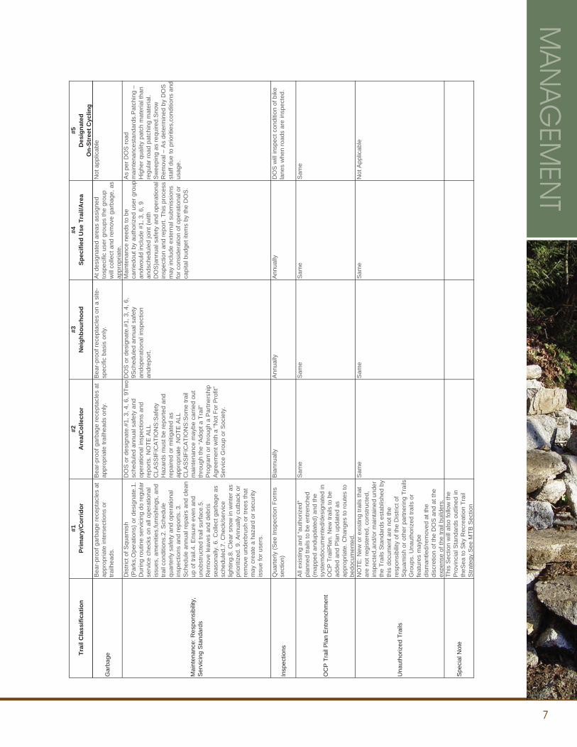
SLOPED SLOPED
7.00
75mm MINUS CRUSH GRAVEL SUB BASE
MIN. 75mm OF ASPHALT COURSE(OR HIGHLY COMPACTED SCREENINGS IN LOW USE AREAS)MIN. 150mm OF 20mm MINUS CRUSH BASETO 95% MODIFIED PROCTOR
APPROVED SUBGRADE TO 95% MODIFIED PROCTOR
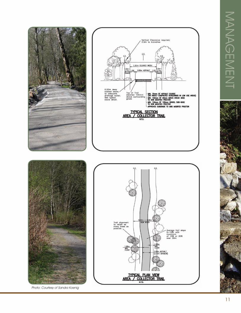
TRAIL TYPESThe diagrams in this section illustrate trail construction standards.
MA
NA
GEM
ENT
Photo: Courtesy of Randy Symons
9
MA
NA
GEM
ENT
1.50m BIKE LANE
2.0%
Photo: Courtesy of Sandra Koenig
10
MA
NA
GEM
ENT
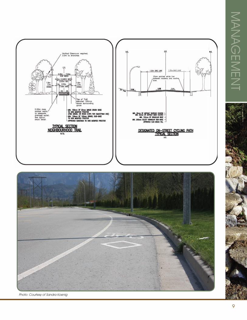
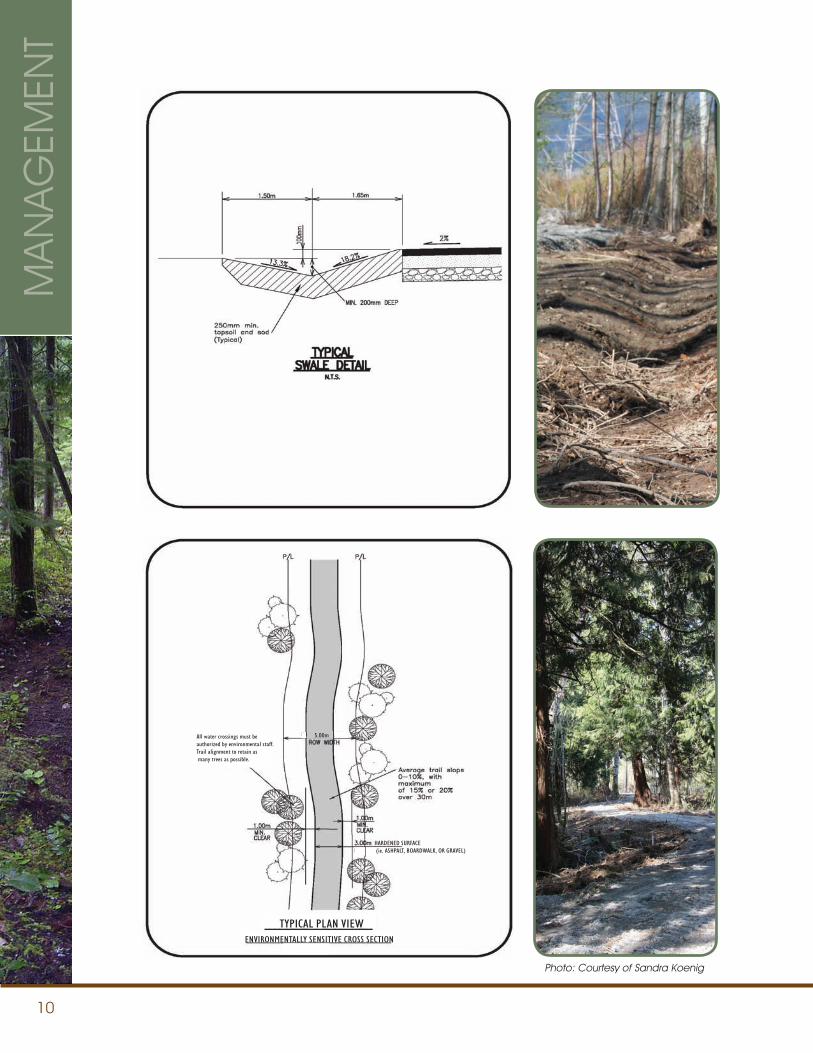
5.00m
TYPICAL PLAN VIEWENVIRONMENTALLY SENSITIVE CROSS SECTION
HARDENED SURFACE (ie. ASHPALT, BOARDWALK, OR GRAVEL)
All water crossings must beauthorized by environmental staff.Trail alignment to retain as many trees as possible.
Photo: Courtesy of Sandra Koenig
11
MA
NA
GEM
ENT
SLOPED SLOPED
5.00
Photo: Courtesy of Sandra Koenig
12
TRAIL MAINTENANCE AND INSPECTION STANDARDS
An effective Trail Maintenance System requires regularly scheduled inspections, scheduled priority servicing, and proper record keeping.
INSPECTIONS, REPORTS, RECORD KEEPINGAll trails that will come under these Trail Standards must be inventoried and have scheduled inspections and scheduled servicing when required. Trained Trail Inspectors will file reports and maintain records on all inspection and servicing requirements of the section of trail. The District of Squamish will schedule inspections and determine servicing requirements.
PRIORITIESEffective risk management requires that safety, security, and critical signage issues take precedent over other issues such as underbrush/vegetation clearing, surface servicing, branch removal, and remedial work. In some cases environmental issues may require immediate response. The District of Squamish, in consultation with the appropriate bodies, will determine priority items along with the Sea to Sky Recreational Trail Steering Committee in conjunction with the Province.
SCHEDULED SERVICING AND UNSCHEDULED TRIGGERSSchedule servicing may be changed/altered by the District of Squamish based on a number of factors, including risk management issues, public complaints, Council or Administrative directives and unscheduled “windows of opportunity” where resources or time factors require a quick response.
Unscheduled maintenance triggers include:• Vegetation loss
• Deterioration of Technical Trail Features (TTF)
• Soil Loss
• Trail widening
• Short-cutting of switchbacks or climbing turns
PUBLIC INPUT/CONCERNSAll public requests and concerns will be documented and responded to in a timely manner. Files and records of these issues will be maintained.
TRAIL DEACTIVATION/DEMOLITION/REMOVALOccasionally, it may be necessary to temporarily or permanently deactivate or remove a trail from public access. It is important that the reasons for such action are well-documented, that all known stakeholders are consulted, and appropriate internal and external communication is provided. When required, appropriate signage will be used to alert the public to closed or deactivated trails.
FORMS/RECORDSSee Appendix for Trail Inspections and Servicing Requests forms.
MA
NA
GEM
ENT
ACCESSIBILITY
Where possible, the District of Squamish will strive to meet accessibility standards related to width, surfacing and grade. See accessibility standards on page 6.
13
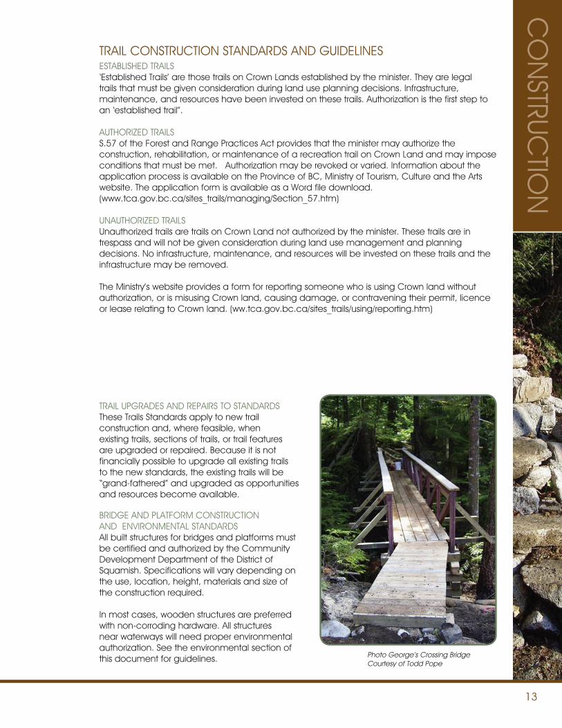
TRAIL CONSTRUCTION STANDARDS AND GUIDELINES
TRAIL UPGRADES AND REPAIRS TO STANDARDSThese Trails Standards apply to new trail construction and, where feasible, when existing trails, sections of trails, or trail features are upgraded or repaired. Because it is not financially possible to upgrade all existing trails to the new standards, the existing trails will be “grand-fathered” and upgraded as opportunities and resources become available.
BRIDGE AND PLATFORM CONSTRUCTIONAND ENVIRONMENTAL STANDARDSAll built structures for bridges and platforms must be certified and authorized by the Community Development Department of the District of Squamish. Specifications will vary depending on the use, location, height, materials and size of the construction required.
In most cases, wooden structures are preferred with non-corroding hardware. All structures near waterways will need proper environmental authorization. See the environmental section of this document for guidelines.
ESTABLISHED TRAILS‘Established Trails’ are those trails on Crown Lands established by the minister. They are legal trails that must be given consideration during land use planning decisions. Infrastructure, maintenance, and resources have been invested on these trails. Authorization is the first step to an ‘established trail”.
AUTHORIZED TRAILSS.57 of the Forest and Range Practices Act provides that the minister may authorize the construction, rehabilitation, or maintenance of a recreation trail on Crown Land and may impose conditions that must be met. Authorization may be revoked or varied. Information about the application process is available on the Province of BC, Ministry of Tourism, Culture and the Arts website. The application form is available as a Word file download. (www.tca.gov.bc.ca/sites_trails/managing/Section_57.htm)
UNAUTHORIZED TRAILSUnauthorized trails are trails on Crown Land not authorized by the minister. These trails are in trespass and will not be given consideration during land use management and planning decisions. No infrastructure, maintenance, and resources will be invested on these trails and the infrastructure may be removed.
The Ministry’s website provides a form for reporting someone who is using Crown land without authorization, or is misusing Crown land, causing damage, or contravening their permit, licence or lease relating to Crown land. (ww.tca.gov.bc.ca/sites_trails/using/reporting.htm)
CO
NSTRUC
TION
Photo George’s Crossing BridgeCourtesy of Todd Pope
14
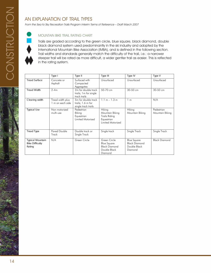
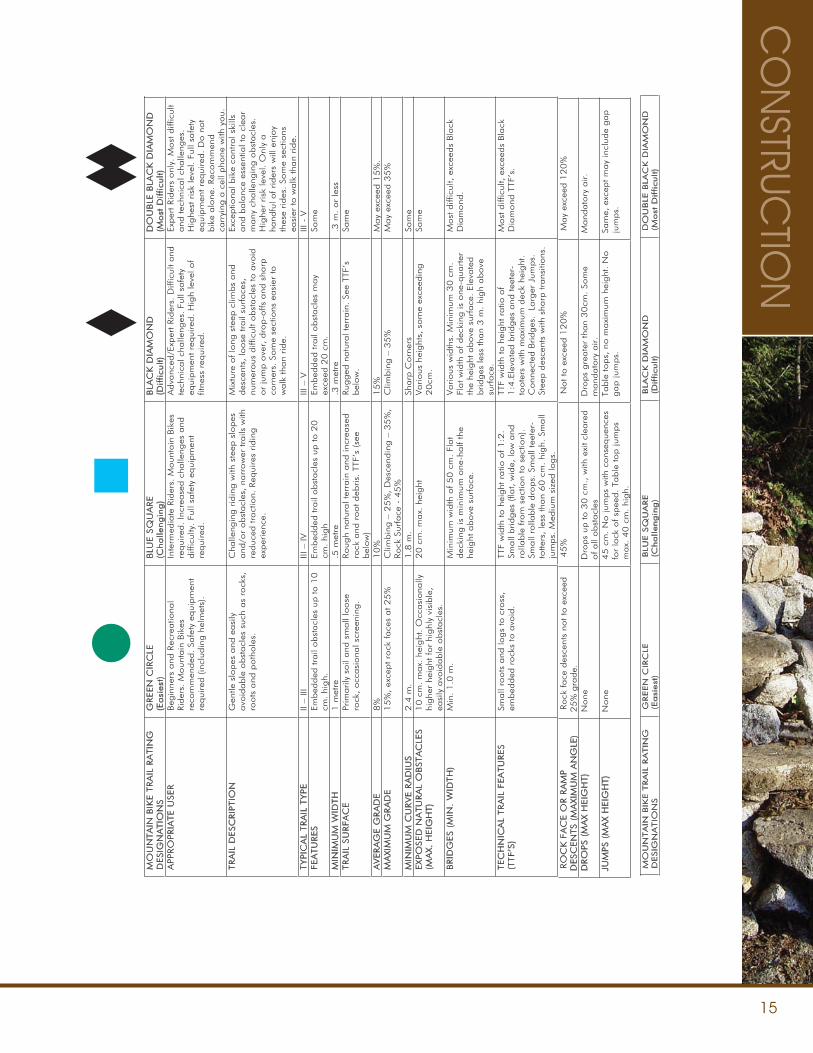
MOUNTAIN BIKE TRAIL RATING CHART
Trails are graded according to the green circle, blue square, black diamond, double black diamond system used predominantly in the ski industry and adopted by the International Mountain Bike Association (IMBA), and is defined in the following section. Trail widths and standards generally match the difficulty of the trail, i.e.: a narrower steeper trail will be rated as more difficult, a wider gentler trail as easier. This is reflected in the rating system.
From the Sea to Sky Recreation Trails Program Interim Terms of Reference – Draft March 2007
Type I Type II Type III Type IV Type V
Tread Surface Concrete or Asphalt
Surfaced with Compacted Aggregates
Unsurfaced Unsurfaced Unsurfaced
Tread Width 2-4m 2m for double track trails; 1m for single track trails
50-70 cm 30-50 cm 30-50 cm
C learing width Tread width plus 1 m on each side
5m for double track trails; 1.6 m for single track trails
1.1 m – 1.3 m 1 m N/A
Typical Use Non motorized multi-use
Pedestrian Biking Equestrian Limited Motorized
Hiking Mountain Biking Trails Riding Equestrian Limited Motorized
Hiking Mountain Biking
Pedestrian Mountain Biking
Tread Type Paved Double Track
Double track or Single Track
Single track Single Track Single Track
Typical Mountain Bike Di�culty Rating
N/A Green Circle Green Circle Blue Square Black Diamond Double Black Diamond
Blue Square Black Diamond Double Black Diamond
Black Diamond
AN EXPLANATION OF TRAIL TYPESC
ON
STRU
CTIO
N
15
CO
NSTRUC
TION
MO
UN
TA
IN B
IKE T
RA
IL R
ATIN
G
DESIG
NA
TI O
NS
GREEN
CI R
CLE
( E
asi
es t
)B
LUE S
QU
ARE
(Challe
ngin
g)
BL A
CK
DIA
MO
ND
(D
ifficu
lt)
D
OU
BLE
BLA
CK
DIA
MO
ND
(M
ost
Difficu
lt)
APPRO
PRIA
TE U
SER
Beg
inne
rs a
nd R
ecre
atio
nal
Rid
ers.
Mount
ain
Bik
es
reco
mm
ended
. Sa
fety
equip
men
t re
quired
(in
cludin
g h
elm
ets)
.
Inte
rmed
iate
Rid
ers.
Mount
ain
Bik
es
required
. In
crea
sed c
halle
nges
and
diff
iculty
. Fu
ll sa
fety
equip
men
t re
quired
.
Adva
nced
/Exp
ert Rid
ers.
Diff
icult
and
te
chni
cal c
halle
nges
. Fu
ll sa
fety
eq
uip
men
t re
quired
. H
igh
leve
l of
fitne
ss r
equired
.
Exper
t Rid
ers
onl
y. M
ost
diff
icult
and
tec
hnic
al c
halle
nges
. H
ighe
st r
isk
leve
l. Fu
ll sa
fety
eq
uip
men
t re
quired
. D
o n
ot
bik
e alo
ne.
Rec
om
men
d
carr
ying
a c
ell p
hone
with
you.
TRA
IL D
ESC
RIP
TIO
N
Gen
tle s
lopes
and
easi
ly
avo
idable
obst
acl
es s
uch
as
rock
s,
roots
and
poth
ole
s.
Cha
lleng
ing r
idin
g w
ith s
teep
slo
pes
and
/or
obst
acl
es,
narr
ow
er tra
ils w
ith
reduce
d tra
ctio
n. R
equires
rid
ing
exper
ienc
e.
Mix
ture
of lo
ng s
teep
clim
bs
and
des
cent
s, lo
ose
tra
il su
rface
s,
num
erous
diff
icult
obst
acl
es to a
void
or
jum
p o
ver,
dro
p-o
ffs a
nd s
harp
co
rner
s. S
om
e se
ctio
ns e
asi
er to
walk
tha
n ride.
Exce
ptio
nal b
ike
cont
rol s
kills
and
bala
nce
esse
ntia
l to c
lear
many
cha
lleng
ing o
bst
acl
es.
Hig
her
risk
leve
l. O
nly
a
hand
ful o
f rider
s w
ill e
njoy
thes
e rides
. So
me
sect
ions
ea
sier
to w
alk
tha
n ride.
TYPIC
AL
TRA
I L T
YPE
V - III
V – III
VI – III
III – IIFEA
TU
RES
Embed
ded
tra
il obst
acl
es u
p to 1
0
cm. hi
gh.
Em
bed
ded
tra
il obst
acl
es u
p to 2
0
cm. hi
gh
Embed
ded
tra
il obst
acl
es m
ay
exce
ed 2
0 c
m.
Sam
e
MIN
IMU
M W
I DTH
ssel r
o .m
3. erte
m 3.
ertem
5. erte
m 1
TRA
I L S
URFA
CE
Prim
arily
soil
and
sm
all
loose
ro
ck, occ
asi
ona
l scr
eeni
ng.
Rough
natu
ral t
erra
in a
nd in
crea
sed
rock
and
root deb
ris.
TTF
’s (se
e bel
ow
)
Rugged
natu
ral t
erra
in. Se
e TT
F’s
bel
ow
.Sa
me
AV
ERA
GE G
RA
DE
.%
51
deecxe ya
M
%5
1
%0
1
%8
MA
XIM
UM
GRA
DE
15
%, ex
cept ro
ck face
s at 2
5%
C
limbin
g –
25
%,
Des
cend
ing –
35
%,
Rock
Surface
- 4
5%
C
limbin
g –
35
%
May
exce
ed 3
5%
MIN
IMU
M C
URV
E R
AD
IUS
em
aS srenr
oC
prahS
.m
8.1
.m
4.2
EXP
OSED
NA
TU
RA
L O
BSTA
CL E
S
(MA
X. H
EIG
HT)
10 c
m. m
ax.
hei
ght
. O
ccasi
ona
lly
highe
r he
ight
for
highl
y vi
sible
, ea
sily
avo
idable
obst
acl
es.
20
cm
. m
ax.
hei
ght
Various
heig
hts,
som
e ex
ceed
ing
20
cm.
Sam
e
BRID
GES (
MIN
. W
IDTH
) t
alF .mc
05 f
o htdi
w m
umini
M .
m 0.
1 .niM
dec
king
is m
inim
um
one
-half
the
heig
ht a
bove
surf
ace
.
Various
wid
ths.
Min
imum
30 c
m.
Flat w
idth
of dec
king
is o
ne-q
uarter
th
e he
ight
above
surface
. El
evate
d
bridges
less
tha
n 3 m
. hi
gh
above
su
rface
.
Most
diff
icult,
exc
eeds
Bla
ck
Dia
mond
.
TEC
HN
I CA
L TRA
I L F
EA
TU
RES
(TTF’S
)Sm
all
roots
and
logs
to c
ross
, em
bed
ded
rock
s to
avo
id.
TTF
wid
th to h
eight
ratio
of 1
:2.
Small
bridges
(fla
t, w
ide,
low
and
ro
llable
fro
m s
ectio
n to
sec
tion)
. Sm
all
rolla
ble
dro
ps.
Sm
all
teet
er-
totte
rs,
less
tha
n 6
0 c
m. hi
gh.
Sm
all
jum
ps.
Med
ium
siz
ed lo
gs.
TTF
wid
th to h
eight
ratio
of
1:4
.Ele
vate
d b
ridges
and
tee
ter-
toote
rs w
ith m
axi
mum
dec
k he
ight
. C
onne
cted
Bridges
. L
arg
er J
um
ps.
St
eep d
esce
nts
with
sha
rp tra
nsiti
ons
.
Most
diff
icult,
exc
eeds
Bla
ck
Dia
mond
TTF
’s.
RO
CK
FA
CE O
R R
AM
P
DESC
EN
TS (
MA
X IM
UM
AN
GLE
) Rock
face
des
cent
s no
t to
exc
eed
25%
gra
de.
%0
21
deecxe ya
M
%0
21
deecxe ot t
oN
%
54
DRO
PS (
MA
X H
EIG
HT)
deraelc tixe hti
w ,.mc
03
ot p
u sp
orD
eno
Nof all
obst
acl
es
Dro
ps
gre
ate
r th
an
30
cm.
Som
e m
and
ato
ry a
ir.
Mand
ato
ry a
ir.
JUM
PS (
MA
X H
EIG
HT)
secneu
qesnoc hti
w sp
muj
oN .
mc 5
4 en
oN
for
lack
of sp
eed.
Table
top ju
mps
max.
40
cm
. hi
gh.
Table
tops,
no m
axi
mum
hei
ght
. N
o
gap ju
mps.
Sa
me,
exc
ept m
ay
incl
ude
gap
jum
ps.
MO
UN
TA
IN B
IKE T
RA
IL R
ATIN
G
DESI G
NA
TIO
NS
GREEN
CIR
CL E
( E
asi
est
)B
LUE S
QU
ARE
( Challengin
g)
BLA
CK
DIA
MO
ND
(D
ifficult)
D
OU
BLE
BL A
CK
DIA
MO
ND
(M
ost
Difficult)
RO
CK
FA
CE O
R R
AM
P
DESC
EN
TS (
MA
XIM
UM
AN
GLE
) Rock
face
desc
ents
not to
exc
eed
25%
gra
de.
%
02
1 d
eecx
e ya
M
%0
21
de
ecxe
ot to
N
%5
4
DRO
PS (
MA
X H
EIG
HT)
d
era
elc tixe
htiw ,.
mc 0
3 ot
pu s
por
D
en
oN
of all
obst
acl
es
Dro
ps
gre
ate
r th
an 3
0cm
. Som
e
mandato
ry a
ir.
Mandato
ry a
ir.
JUM
PS (
MA
X H
EIG
HT)
sec
ne
uq
esn
oc hti
w sp
muj
oN .
mc 5
4
en
oN
for
lack
of sp
eed.
Table
top jum
ps
max.
40
cm
. hig
h.
Table
tops,
no m
axi
mum
heig
ht. N
o
gap jum
ps.
Sam
e, exc
ept m
ay
incl
ude g
ap
jum
ps.
16
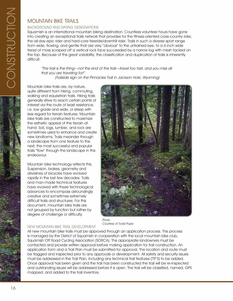
MOUNTAIN BIKE TRAILSBACKGROUND AND RATING DESIGNATIONSSquamish is an international mountain biking destination. Countless volunteer hours have gone into creating an exceptional trails network that provides for the fitness-oriented cross-country rider, the all-day epic rider and hard-core freeride/downhill rider. Trails in such a diverse sport range from wide, flowing, and gentle that are very “obvious” to the untrained eye, to a 6 inch wide tread of moss scraped off a vertical rock face succeeded by a narrow log with mesh tacked on the top. Because of this great variability, the classification and duplication of trails is inherently difficult.
“The trail is the thing—not the end of the trail—travel too fast, and you miss all that you are traveling for!” (Trailside sign on the Pinnacles Trail in Jackson Hole, Wyoming)
Mountain bike trails are, by nature, quite different from hiking, commuting, walking and equestrian trails. Hiking trails generally strive to reach certain points of interest via the route of least resistance, i.e. low grade and wide, or steep with less regard for terrain features. Mountain bike trails are constructed to maximize the esthetic appeal of the terrain at hand. Soil, logs, lumber, and rock are sometimes used to enhance and create new landforms. Trails meander through a landscape from one feature to the next, the most successful and popular trails “flow” through the landscape in this endeavour.
Mountain bike technology reflects this. Suspension, brakes, geometry and drivelines of bicycles have evolved rapidly in the last few decades. Trails and man-made technical features have evolved with these technological advances to encompass astoundingly creative and sometimes extremely difficult trails and structures. For this document, mountain bike trails are not grouped by function but rather by degree of challenge or difficulty.
NEW MOUNTAIN BIKE TRAIL DEVELOPMENTAll new mountain bike trails must be approved through an application process. This process is managed by the District of Squamish in cooperation with the local mountain bike club, Squamish Off Road Cycling Association (SORCA). The appropriate landowners must be contacted and provide written approval before making application for trail construction. An application form and a Trail Plan must be submitted for approval. The location and route must be flagged and inspected prior to any approvals or development. All safety and security issues must be addressed in the Trail Plan, including any technical trail features (TTF’S) to be added. Once approval has been given and the trail has been constructed the trail will be re-inspected and outstanding issues will be addressed before it is open. The trail will be classified, named, GPS mapped, and added to the trail inventory.
PhotoCourtesy of Todd Pope
CO
NST
RUC
TION
17
CO
NSTRUC
TION
CONSTRUCTION STANDARDS AND AUTHORIZED MOUNTAIN BIKE TRAIL BUILDING
Terrain, precipitation and riding styles in Squamish exceed the scope of this manual, specially when constructing black and double black diamond trails. The skill and know-how of an experienced trail builder is invaluable. Input from an “authorized” trail builder is mandatory for all new trail construction project.
Squamish is located in a coastal rainforest and it must be emphasized that water erosion is the largest detrimental force for trails in the Squamish area. Trails located on steep slopes with shallow bedrock are especially prone to turning into drainages when not properly constructed. Care must be taken, especially on steeper trails, to provide for proper water management. Consultation, design approvals and inspections with an authorized trail builder are mandatory.
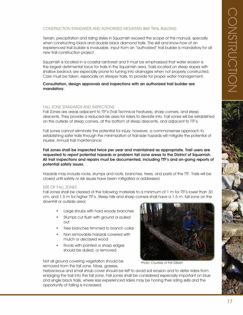
FALL ZONE STANDARDS AND INSPECTIONSFall Zones are areas adjacent to TTF’s (Trail Technical Features), sharp corners, and steep descents. They provide a reduced-risk area for riders to deviate into. Fall zones will be established on the outside of steep corners, at the bottom of steep descents, and adjacent to TTF’s.
Fall zones cannot eliminate the potential for injury; however, a commonsense approach to establishing safer trails through the minimization of trail-side hazards will mitigate the potential of injuries. Annual trail maintenance:
Fall zones shall be inspected twice per year and maintained as appropriate. Trail users are requested to report potential hazards or problem fall zone areas to the District of Squamish. All trail inspections and repairs must be documented, including TTF’s and on-going reports of potential safety issues.
Hazards may include rocks, stumps and roots, branches, trees, and parts of the TTF. Trails will be closed until safety or risk issues have been mitigated or addressed.
SIZE OF FALL ZONES Fall zones shall be cleared of the following materials to a minimum of 1 m for TTF’s lower than 30 cm, and 1.5 m for higher TTF’s. Steep hills and sharp corners shall have a 1.5 m. fall zone on the downhill or outside area:
• Large shrubs with hard woody branches
• Stumps cut flush with ground or pulled out
• Tree branches trimmed to branch collar
• Non removable hazards covered with mulch or decayed wood
• Rocks with pointed or sharp edges should be dulled, or removed
Not all ground covering vegetation should be removed from the fall zone. Moss, grasses, herbaceous and small shrub cover should be left to avoid soil erosion and to deter riders from enlarging the trail into the fall zone. Fall zones shall be considered especially important on blue and single black trails, where less experienced riders may be honing their riding skills and the opportunity of falling is increased.
Photo: Courtesy of Pat Gilbert
18
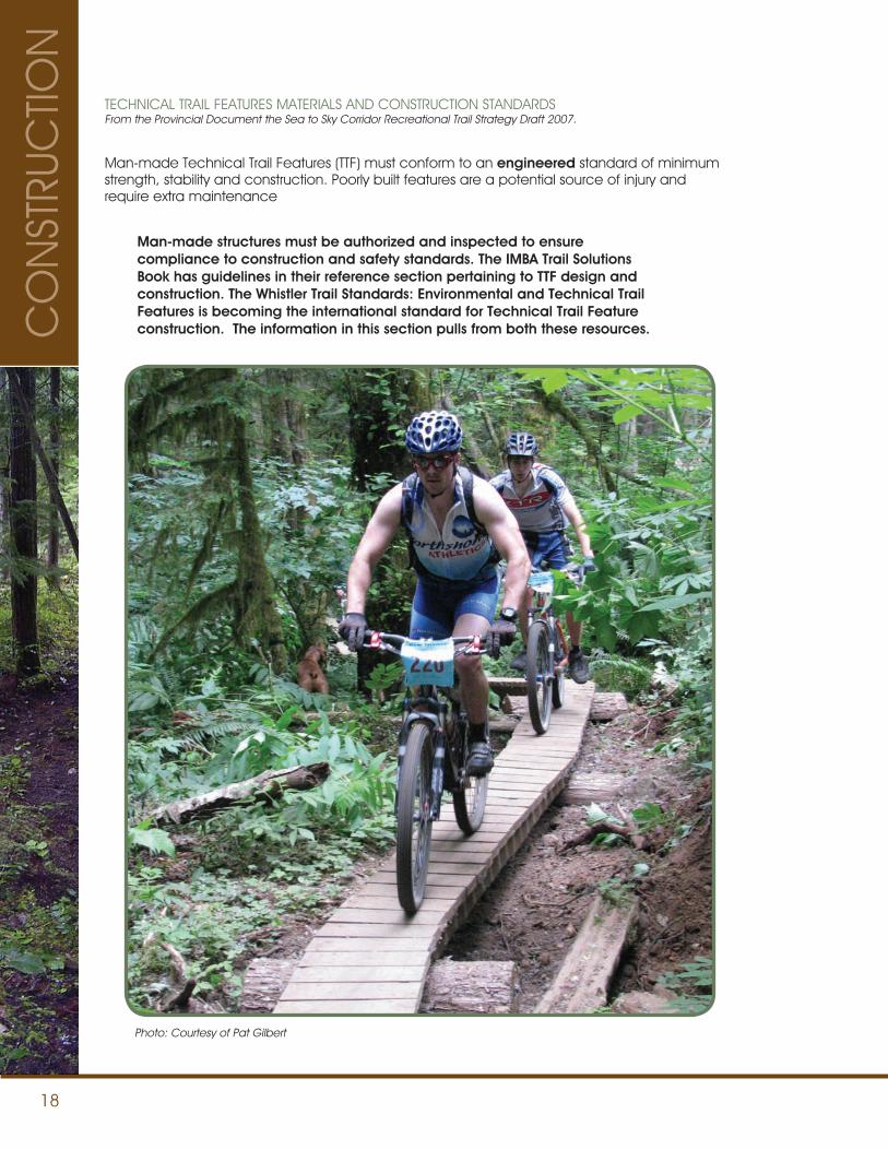
TECHNICAL TRAIL FEATURES MATERIALS AND CONSTRUCTION STANDARDSFrom the Provincial Document the Sea to Sky Corridor Recreational Trail Strategy Draft 2007.
Man-made Technical Trail Features (TTF) must conform to an engineered standard of minimum strength, stability and construction. Poorly built features are a potential source of injury and require extra maintenance
Man-made structures must be authorized and inspected to ensure compliance to construction and safety standards. The IMBA Trail Solutions Book has guidelines in their reference section pertaining to TTF design and construction. The Whistler Trail Standards: Environmental and Technical Trail Features is becoming the international standard for Technical Trail Feature construction. The information in this section pulls from both these resources.
Photo: Courtesy of Pat Gilbert
CO
NST
RUC
TION
19
CO
NSTRUC
TION
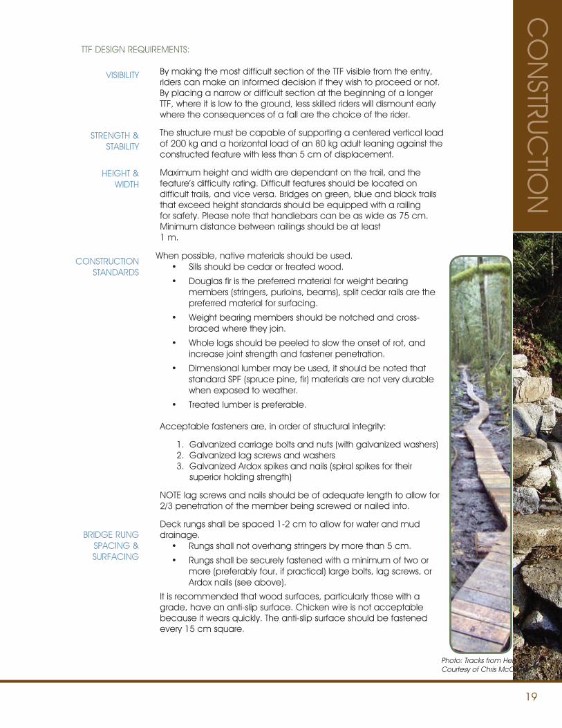
TTF DESIGN REQUIREMENTS:
By making the most difficult section of the TTF visible from the entry, riders can make an informed decision if they wish to proceed or not. By placing a narrow or difficult section at the beginning of a longer TTF, where it is low to the ground, less skilled riders will dismount early where the consequences of a fall are the choice of the rider.
The structure must be capable of supporting a centered vertical load of 200 kg and a horizontal load of an 80 kg adult leaning against the constructed feature with less than 5 cm of displacement.
Maximum height and width are dependant on the trail, and the feature’s difficulty rating. Difficult features should be located on difficult trails, and vice versa. Bridges on green, blue and black trails that exceed height standards should be equipped with a railing for safety. Please note that handlebars can be as wide as 75 cm. Minimum distance between railings should be at least 1 m.
When possible, native materials should be used. • Sills should be cedar or treated wood.
• Douglas fir is the preferred material for weight bearing members (stringers, purloins, beams), split cedar rails are the preferred material for surfacing.
• Weight bearing members should be notched and cross-braced where they join.
• Whole logs should be peeled to slow the onset of rot, and increase joint strength and fastener penetration.
• Dimensional lumber may be used, it should be noted that standard SPF (spruce pine, fir) materials are not very durable when exposed to weather.
• Treated lumber is preferable.
Acceptable fasteners are, in order of structural integrity:
1. Galvanized carriage bolts and nuts (with galvanized washers) 2. Galvanized lag screws and washers 3. Galvanized Ardox spikes and nails (spiral spikes for their superior holding strength)
NOTE lag screws and nails should be of adequate length to allow for 2/3 penetration of the member being screwed or nailed into.
Deck rungs shall be spaced 1-2 cm to allow for water and mud drainage.
• Rungs shall not overhang stringers by more than 5 cm.
• Rungs shall be securely fastened with a minimum of two or more (preferably four, if practical) large bolts, lag screws, or Ardox nails (see above).
It is recommended that wood surfaces, particularly those with a grade, have an anti-slip surface. Chicken wire is not acceptable because it wears quickly. The anti-slip surface should be fastened every 15 cm square.
VISIBILITY
STRENGTH & STABILITY
HEIGHT & WIDTH
CONSTRUCTION STANDARDS
BRIDGE RUNG SPACING & SURFACING
Photo: Tracks from HellCourtesy of Chris McCrum
20
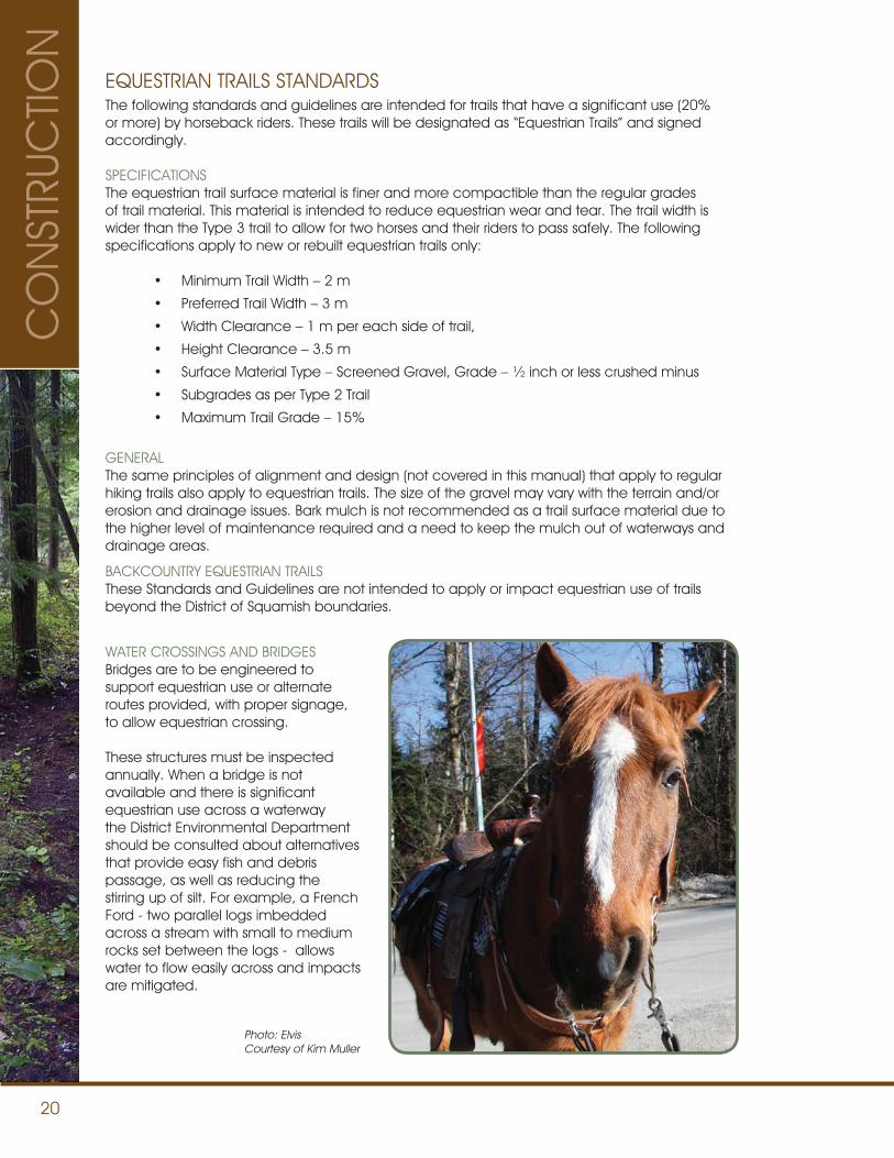
WATER CROSSINGS AND BRIDGESBridges are to be engineered to support equestrian use or alternate routes provided, with proper signage, to allow equestrian crossing.
These structures must be inspected annually. When a bridge is not available and there is significant equestrian use across a waterway the District Environmental Department should be consulted about alternatives that provide easy fish and debris passage, as well as reducing the stirring up of silt. For example, a French Ford - two parallel logs imbedded across a stream with small to medium rocks set between the logs - allows water to flow easily across and impacts are mitigated.
EQUESTRIAN TRAILS STANDARDSThe following standards and guidelines are intended for trails that have a significant use (20%or more) by horseback riders. These trails will be designated as “Equestrian Trails” and signed accordingly.
SPECIFICATIONS The equestrian trail surface material is finer and more compactible than the regular grades of trail material. This material is intended to reduce equestrian wear and tear. The trail width is wider than the Type 3 trail to allow for two horses and their riders to pass safely. The following specifications apply to new or rebuilt equestrian trails only:
• Minimum Trail Width – 2 m
• Preferred Trail Width – 3 m
• Width Clearance – 1 m per each side of trail,
• Height Clearance – 3.5 m
• Surface Material Type – Screened Gravel, Grade – ½ inch or less crushed minus
• Subgrades as per Type 2 Trail
• Maximum Trail Grade – 15%
GENERALThe same principles of alignment and design (not covered in this manual) that apply to regular hiking trails also apply to equestrian trails. The size of the gravel may vary with the terrain and/or erosion and drainage issues. Bark mulch is not recommended as a trail surface material due to the higher level of maintenance required and a need to keep the mulch out of waterways and drainage areas.
BACKCOUNTRY EQUESTRIAN TRAILSThese Standards and Guidelines are not intended to apply or impact equestrian use of trails beyond the District of Squamish boundaries.
Photo: ElvisCourtesy of Kim Muller
CO
NST
RUC
TION
21
CO
NSTRUC
TION
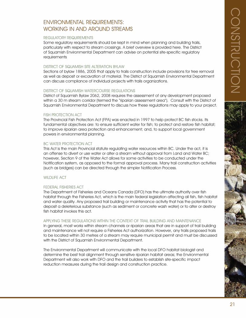
ENVIRONMENTAL REQUIREMENTS: WORKING IN AND AROUND STREAMSREGULATORY REQUIREMENTSSome regulatory requirements should be kept in mind when planning and building trails, particularly with respect to stream crossings. A brief overview is provided here. The District of Squamish Environmental Department can advise on potential site-specific regulatory requirements
DISTRICT OF SQUAMISH SITE ALTERATION BYLAWSections of bylaw 1886, 2005 that apply to trails construction include provisions for tree removal as well as deposit or excavation of material. The District of Squamish Environmental Department can discuss compliance of individual projects with trails organizations.
DISTRICT OF SQUAMISH WATERCOURSE REGULATIONSDistrict of Squamish Bylaw 2062, 2008 requires the assessment of any development proposed within a 30 m stream corridor (termed the “riparian assessment area”). Consult with the District of Squamish Environmental Department to discuss how these regulations may apply to your project.
FISH PROTECTION ACTThe Provincial Fish Protection Act (FPA) was enacted in 1997 to help protect BC fish stocks. Its fundamental objectives are: to ensure sufficient water for fish; to protect and restore fish habitat; to improve riparian area protection and enhancement; and, to support local government powers in environmental planning.
BC WATER PROTECTION ACTThis Act is the main Provincial statute regulating water resources within BC. Under the act, it is an offense to divert or use water or alter a stream without approval from Land and Water BC; however, Section 9 of the Water Act allows for some activities to be conducted under the Notification system, as opposed to the formal approval process. Many trail construction activities (such as bridges) can be directed through the simpler Notification Process.
WILDLIFE ACT
FEDERAL FISHERIES ACTThe Department of Fisheries and Oceans Canada (DFO) has the ultimate authority over fish habitat through the Fisheries Act, which is the main federal legislation affecting all fish, fish habitat and water quality. Any proposed trail building or maintenance activity that has the potential to deposit a deleterious substance (such as sediment or concrete wash water) or to alter or destroy fish habitat invokes this act.
APPLYING THESE REGULATIONS WITHIN THE CONTEXT OF TRAIL BUILDING AND MAINTENANCEIn general, most works within stream channels or riparian areas that are in support of trail building and maintenance will not require a Fisheries Act authorization. However, any trails proposed trails to be located within 30 metres of a stream may require municipal permit and must be discussed with the District of Squamish Environmental Department.
The Environmental Department will communicate with the local DFO habitat biologist and determine the best trail alignment through sensitive riparian habitat areas; the Environmental Department will also work with DFO and the trail builders to establish site-specific impact reduction measures during the trail design and construction practice.
22
Trail builders may be subject to any permit requirements under either the BC Water Act or the Riparian Areas Regulation. Contact the District Environmental Department for assistance in preparing a Notification Form (Water Act) or to ensure that your project is in compliance with the Fisheries Act and the District of Squamish Watercourse Regulations.
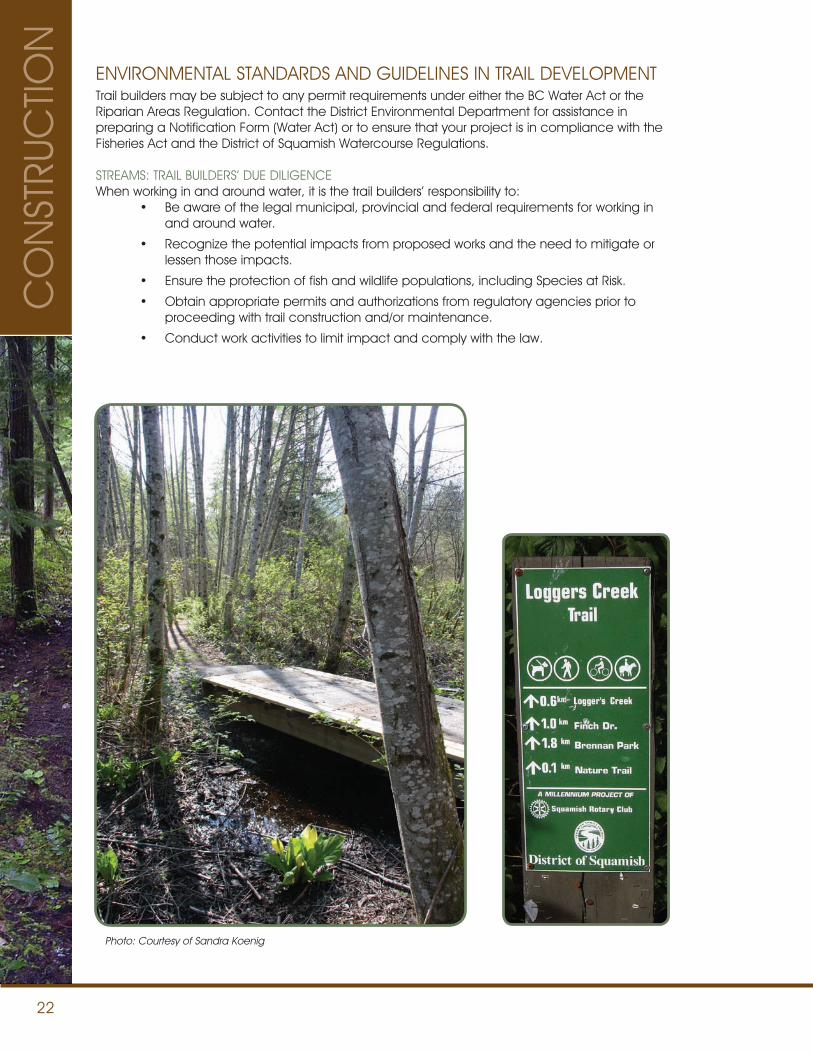
STREAMS: TRAIL BUILDERS’ DUE DILIGENCEWhen working in and around water, it is the trail builders’ responsibility to:
• Be aware of the legal municipal, provincial and federal requirements for working in and around water.
• Recognize the potential impacts from proposed works and the need to mitigate or lessen those impacts.
• Ensure the protection of fish and wildlife populations, including Species at Risk.
• Obtain appropriate permits and authorizations from regulatory agencies prior to proceeding with trail construction and/or maintenance.
• Conduct work activities to limit impact and comply with the law.
ENVIRONMENTAL STANDARDS AND GUIDELINES IN TRAIL DEVELOPMENT
Photo: Courtesy of Sandra Koenig
CO
NST
RUC
TION
23
CO
NSTRUC
TION
STREAM CROSSINGS AND SETBACKS Installing stream crossings for trail building and maintenance is the area of a trails project that could result in the greatest environmental impact. If done improperly, stream crossings can have both shortterm and longterm impacts on streams, including sediment transport and deposition and blocked fish access to spawning and rearing areas.
Some terminology is introduced here to aid trail builders in understanding the legislation and Best Management Practices (BMP) applicable to stream crossing projects.
The International Mountain Bicycling Association (IMBA) has an excellent publication called “Trail Solutions” which outlines the construction of mountain bike trails. Portions of this environmental section reference specific sections of this IMBA publication.
DEFINITIONS
Sometimes referred to as “riparian zone”. This is the area on either side of a stream. For the purposes of this trails standards document, the riparian area extends 30 m landward from the top of bank of the stream channel.
The riparian area performs numerous beneficial habitat and flood control functions; including supplying food and nutrients to aquatic species (fish, invertebrates, etc) and storing runoff from large storm events.
Sometimes referred to as “riparian leave-strip”, “leave-strip”, or “buffer”. The setback denotes the zone immediately adjacent to the channel where development is either, a) not allowed, or b) allowed only in a very limited capacity. Typically, riparian setbacks are as follows:
•30mfromchanneltopofbankforfish-bearingand/orpermanent watercourses;
•15mfromchanneltopofbankfornon-fish-bearingand/orephemeral watercourses. The District of Squamish Environmental Department can advise as to
whether the stream you are working on is fish bearing or non-fish-bearing.
Watercourses that contain year-round flows.
Watercourses that only flow part of the year (for example, flow approximately 6 months of the year, or only during large storm events).
RIPARIAN AREA
RIPARIAN SETBACK
PERMANENT STREAMS
EPHEMERAL STREAMS
24
EROSION AND SEDIMENT CONTROL(Reference Trail Solutions: IMBA’s Guide to Building Sweet Singletrack. Section Understanding Soils, pages 84-85)
Best Practices during trail construction: working within the riparian area or “in stream”
Next to poorly constructed stream crossings, erosion at the works site and sediment deposit in adjacent watercourses have the next greatest potential to impact streams and riparian habitats.
Numerous guidelines for erosion control on trail projects exist. This section provides a brief overview of erosion/sedimentation Best Management Practices (BMPs) for trails projects in Squamish.
The District Environmental Department can provide additional design details for selected sedimentation control measures on a site-specific basis.
Water drainage features are necessary to prevent erosion along trails on slopes and to avoid standing water on trails on flat ground. The frequency, size and type of control structures depend on erosion potential of the soils under the trail. For example, sandy soils are less erosive than clay soils because of the large grain size and porosity of sands. Two other important factors include the velocity of water along the trail (which depends on the slope), and the length of time, or distance, running water is allowed on the trail. Most erosion control measures are designed to reduce the velocity and/or the distance of water running on the trail. Such measures must be installed immediately after clearing and prior to trail construction. The trail design process can incorporate recommendations to minimize soil erosion for specific soil types. Details of the prescriptions, and where they occur, should be described in the final trail plan for individual projects. Some erosion/sedimentation BMPs appropriate for trails projects include: straw bale barriers, silt fencing, and temporary sediment traps.
STORM WATER MANAGEMENT AND TRAIL BUILDINGThe District is increasingly advocating the infiltration of storm water as a policy for all new developments. Returning storm water to the ground helps to maintain summertime base flows, thereby ensuring sufficient water supply for rearing fish. While recreational trails arguably may not have much impact on local hydrology, the District still believes that infiltration of rainwater should be a priority on all new trails, particularly for the larger Primary and Area/Collector Trails (#1 and2).
Vegetated swales along trail alignments can be used to aid in infiltrating the rainwater that would otherwise be conveyed off the trail via surface runoff into the closest municipal storm sewer culvert and lost for groundwater recharge.
The swale system can be effective even in soil types such as clays, which have a very low infiltration rate. However, use of the swales may be limited in areas where the water table is very near the surface (< 0.6 m). The District Environmental Department and the project engineer can provide guidance in selecting an infiltration measure suitable to the trail site conditions.
CO
NST
RUC
TION
25
CO
NSTRUC
TION
FISHERIES ISSUESConstruction timing and work windows guidelines.
Construction sequencing and the timing of in-stream works during the “fish window” will significantly reduce a trail project’s potential for adverse environmental impact. In general, keep these guidelines in mind:
• Coordinate the construction schedule to minimize the amount of area disturbed at any one time.
• Coordinate land clearing for the trail and stream crossings with the installation of erosion control measures.
• Minimizing the disturbed area reduces the potential for erosion.
• Halt clearing and in-stream works during periods of heavy rainfall.
• Construct in-stream works (channel crossings) during the summer work window (the “fish window”) when use of watercourses by salmon is at a minimum. The District Environmental Department can advise on specific dates of window, but in Squamish, it’s generally from mid-June to mid-August, depending on weather.
Work area isolationWhen installing watercourse crossings Isolate work areas within streams to minimize erosion and sedimentation. Pump water from within the in-stream work area to a land site where it will infiltrate through the soil, or settle out sediment, prior to returning to the stream. Revegetate areas of disturbed riparian vegetation.
Fish SalvageFish Salvage is the relocation of live fish from a work site to a safe location above or below the site. If channel dewatering is required to complete the trail project, fish should be salvaged from the dewatering site and returned to the stream. The person undertaking the fish salvage and/or fish passage operations should consult with the District Environmental Department and obtain and hold all necessary permits required by DFO.
Fish PassageFor Stream Crossings (Reference section: IMBA Wetlands and Water Crossings, pp.176186).
All stream crossings must be constructed so as to allow upstream and downstream access for migratory fish (e.g., salmon). Passage must be ensured during both high and low flows, and for juvenile as well as adult fish. Bridges are the preferred crossing mechanism, installed from just above the channel top of bank. Where bridges are not feasible, culverts can be installed in accordance with the following requirements:
• Provide culverts large enough to allow fish passage in all flow conditions. Open bottom culverts are a viable alternative.
• Maintain a minimum depth of water to allow continuous fish passage at all times.
• Maintain drops in water surface small enough to allow fish passage upstream.
• Install the culvert such that the downstream invert is well below grade to accommodate changes in streambed elevation.
Round or elliptical corrugated metal culverts do not provide good fish access, concentrate flows and velocity (increasing erosion potential), and are generally unsuitable for fish passage.
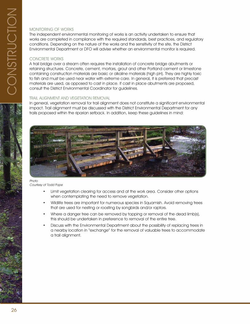
26
MONITORING OF WORKSThe independent environmental monitoring of works is an activity undertaken to ensure that works are completed in compliance with the required standards, best practices, and regulatory conditions. Depending on the nature of the works and the sensitivity of the site, the District Environmental Department or DFO will advise whether an environmental monitor is required.
CONCRETE WORKSA trail bridge over a stream often requires the installation of concrete bridge abutments or retaining structures. Concrete, cement, mortars, grout and other Portland cement or limestone containing construction materials are basic or alkaline materials (high pH). They are highly toxic to fish and must be used near water with extreme care. In general, it is preferred that precast materials are used, as opposed to cast in place. If cast in place abutments are proposed, consult the District Environmental Coordinator for guidelines.
TRAIL ALIGNMENT AND VEGETATION REMOVALIn general, vegetation removal for trail alignment does not constitute a significant environmental impact. Trail alignment must be discussed with the District Environmental Department for any trails proposed within the riparian setback. In addition, keep these guidelines in mind:
• Limit vegetation clearing for access and at the work area. Consider other options when contemplating the need to remove vegetation.
• Wildlife trees are important for numerous species in Squamish. Avoid removing trees that are used for nesting or roosting by songbirds and/or raptors.
• Where a danger tree can be removed by topping or removal of the dead limb(s), this should be undertaken in preference to removal of the entire tree.
• Discuss with the Environmental Department about the possibility of replacing trees in a nearby location in “exchange” for the removal of valuable trees to accommodate a trail alignment.
PhotoCourtesy of Todd Pope
CO
NST
RUC
TION
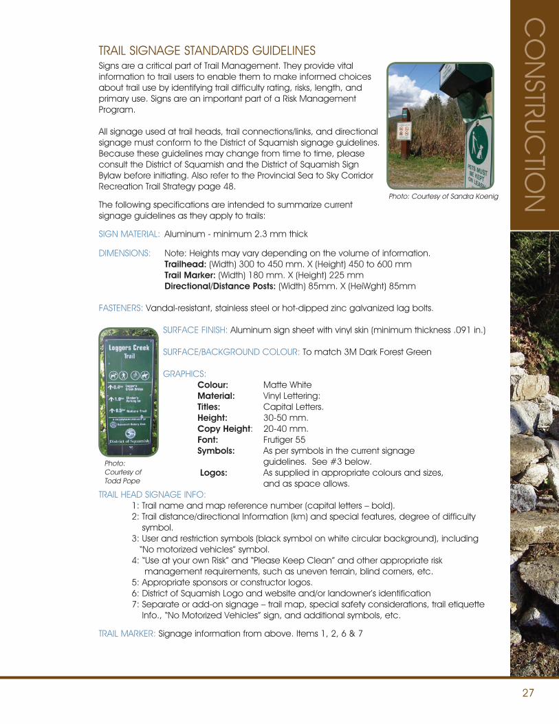
27
CO
NSTRUC
TION
TRAIL SIGNAGE STANDARDS GUIDELINESSigns are a critical part of Trail Management. They provide vital information to trail users to enable them to make informed choices about trail use by identifying trail difficulty rating, risks, length, and primary use. Signs are an important part of a Risk Management Program.
All signage used at trail heads, trail connections/links, and directional signage must conform to the District of Squamish signage guidelines. Because these guidelines may change from time to time, please consult the District of Squamish and the District of Squamish Sign Bylaw before initiating. Also refer to the Provincial Sea to Sky Corridor Recreation Trail Strategy page 48.
The following specifications are intended to summarize currentsignage guidelines as they apply to trails:
SIGN MATERIAL: Aluminum - minimum 2.3 mm thick
DIMENSIONS: Note: Heights may vary depending on the volume of information. Trailhead: (Width) 300 to 450 mm. X (Height) 450 to 600 mm Trail Marker: (Width) 180 mm. X (Height) 225 mm Directional/Distance Posts: (Width) 85mm. X (HeiWght) 85mm
FASTENERS: Vandal-resistant, stainless steel or hot-dipped zinc galvanized lag bolts.
SURFACE FINISH: Aluminum sign sheet with vinyl skin (minimum thickness .091 in.)
SURFACE/BACKGROUND COLOUR: To match 3M Dark Forest Green
GRAPHICS: Colour: Matte White Material: Vinyl Lettering: Titles: Capital Letters. Height: 30-50 mm. Copy Height: 20-40 mm. Font: Frutiger 55 Symbols: As per symbols in the current signage guidelines. See #3 below.
Logos: As supplied in appropriate colours and sizes, and as space allows. TRAIL HEAD SIGNAGE INFO: 1: Trail name and map reference number (capital letters – bold). 2: Trail distance/directional Information (km) and special features, degree of difficulty symbol. 3: User and restriction symbols (black symbol on white circular background), including “No motorized vehicles” symbol. 4: “Use at your own Risk” and “Please Keep Clean” and other appropriate risk management requirements, such as uneven terrain, blind corners, etc. 5: Appropriate sponsors or constructor logos. 6: District of Squamish Logo and website and/or landowner’s identification 7: Separate or add-on signage – trail map, special safety considerations, trail etiquette Info., “No Motorized Vehicles” sign, and additional symbols, etc.
TRAIL MARKER: Signage information from above. Items 1, 2, 6 & 7
Photo:Courtesy of Todd Pope
Photo: Courtesy of Sandra Koenig
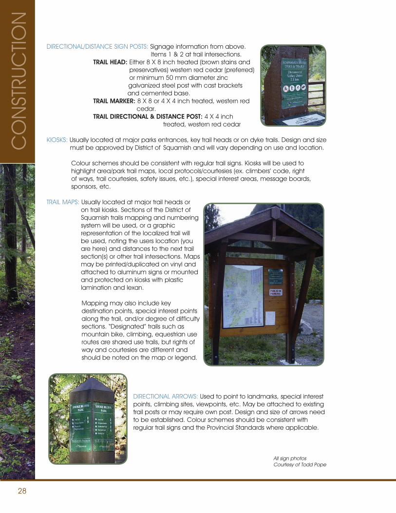
28
DIRECTIONAL/DISTANCE SIGN POSTS: Signage information from above. Items 1 & 2 at trail intersections. TRAIL HEAD: Either 8 X 8 inch treated (brown stains and preservatives) western red cedar (preferred) or minimum 50 mm diameter zinc galvanized steel post with cast brackets and cemented base. TRAIL MARKER: 8 X 8 or 4 X 4 inch treated, western red cedar. TRAIL DIRECTIONAL & DISTANCE POST: 4 X 4 inch treated, western red cedar
KIOSKS: Usually located at major parks entrances, key trail heads or on dyke trails. Design and size must be approved by District of Squamish and will vary depending on use and location.
Colour schemes should be consistent with regular trail signs. Kiosks will be used to highlight area/park trail maps, local protocols/courtesies (ex. climbers’ code, right of ways, trail courtesies, safety issues, etc.), special interest areas, message boards, sponsors, etc.
TRAIL MAPS: Usually located at major trail heads or on trail kiosks. Sections of the District of Squamish trails mapping and numbering system will be used, or a graphic representation of the localized trail will be used, noting the users location (you are here) and distances to the next trail section(s) or other trail intersections. Maps may be printed/duplicated on vinyl and attached to aluminum signs or mounted and protected on kiosks with plastic lamination and lexan.
Mapping may also include key destination points, special interest points along the trail, and/or degree of difficulty sections. “Designated” trails such as mountain bike, climbing, equestrian use routes are shared use trails, but rights of way and courtesies are different and should be noted on the map or legend.
DIRECTIONAL ARROWS: Used to point to landmarks, special interest points, climbing sites, viewpoints, etc. May be attached to existing trail posts or may require own post. Design and size of arrows need to be established. Colour schemes should be consistent with regular trail signs and the Provincial Standards where applicable.
All sign photosCourtesy of Todd Pope
CO
NST
RUC
TION
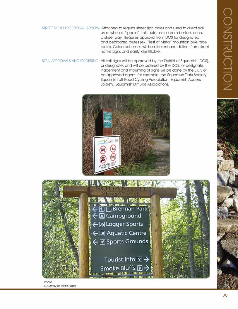
29
CO
NSTRUC
TION
STREET SIGN DIRECTIONAL ARROW: Attached to regular street sign poles and used to direct trail users when a “special” trail route uses a path beside, or on, a street way. Requires approval from DOS for designated and dedicated routes (ex. “Test of Metal” mountain bike race route). Colour schemes will be different and distinct from street name signs and easily identifiable.
SIGN APPROVALS AND ORDERING: All trail signs will be approved by the District of Squamish (DOS), or designate, and will be ordered by the DOS, or designate. Placement and mounting of signs will be done by the DOS or an approved agent (for example, the Squamish Trails Society, Squamish off Road Cycling Association, Squamish Access Society, Squamish Dirt Bike Association).
PhotoCourtesy of Todd Pope
30
Squamish’s extensive trail network is used by a wide variety of users including hikers, trail runners, mountain bikers, motorized bike riders, equestrian riders, and climbers. Many trails are ‘shared use’ and conflict can arise between users. Signs that identify a trail as multi-use (ex. mountain biking and motorized biking) inform users to expect to encounter each other, identify the primary use of the trail and who has the ‘right of way’, can reduce the likelihood of conflict.
User groups such as Trials Riders, Squamish Off Road Cycling Association, Squamish Dirt Bike Association, and Squamish Climbers’ Associations have created codes of conduct to help minimize potential user conflicts and promote respect between user groups.
All users - motorized or non-motorized, wheeled or non-wheeled - should respect each others’ right to trail access and enjoyment. All users should be familiar with the other groups’ user information. When in doubt, please be courteous and give the other user the right of way.
To get involved, please contact the your local users’ group or visit www.squamish.ca.
Trails users should not only respect each other but also the area’s natural inhabitants.
Squamish is located in prime black bear habitat and trail users should be prepared to encounter a bear. These guidelines help ensure any encounters with bears are positive and free from conflict.
USER HARMONY
RESPECT BEAR HABITAT
DOGS ON TRAILSOn main hiking trails dogs must be on a leash, even for cyclists. On designated back country mountain bike trails, while it is not safe or practical to expect mountain bikers to have dogs on leash, it is expected that dog owners will have their dogs under control. Complaints about dogs may result in the owner’s dog being barred from mountain bike trail access.
Dog feces creates hazards to humans and wildlife. Owners are to clean up after their pet.
HORSESAll users should be aware that horses can be shy and easily frightened. Extra care should be exercised when encountering an equestrian user. Please see equestrian section on page 35 for more details.
• Stay alert and look for signs: scat, claw marks on trees, broken up rotted logs, overturned rocks, berry bushes, and possible daybed areas.
• Make some noise: traveling fast on moving mountain bikes can lead to surprise encounters.
• Avoid surprise encounters: make your presence known by talking loudly, singing songs, cracking sticks, or banging rocks especially when near loud stream/rivers, going around blind corners and when in areas with dense berry bushes.
• Pack out what you pack in. Bears have a keen sense of smell. Never feed a bear – intentionally or unintentionally.
• Keep all dogs on leash and under control. Dogs can be helpful in detecting bears but they may also aggravate or lead a bear back to you.
• If you see a bear remain calm and assess the situation. Identify yourself as human by talking in a calm tone of voice. Back away slowly in the direction you came from to increase the distance between you and the bear. Do not run. In most cases the bear will flee.
USER
INFO
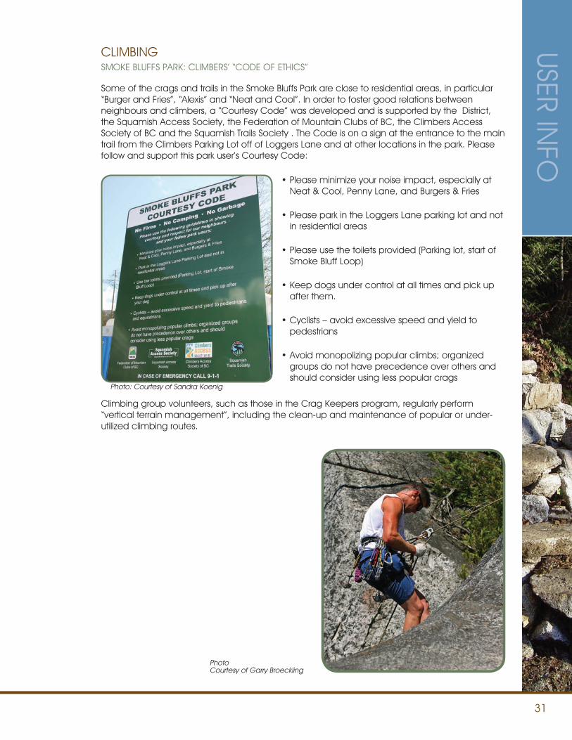
31
USER INFO
Some of the crags and trails in the Smoke Bluffs Park are close to residential areas, in particular “Burger and Fries”, “Alexis” and “Neat and Cool”. In order to foster good relations between neighbours and climbers, a “Courtesy Code” was developed and is supported by the District, the Squamish Access Society, the Federation of Mountain Clubs of BC, the Climbers Access Society of BC and the Squamish Trails Society . The Code is on a sign at the entrance to the main trail from the Climbers Parking Lot off of Loggers Lane and at other locations in the park. Please follow and support this park user’s Courtesy Code:
CLIMBING
Climbing group volunteers, such as those in the Crag Keepers program, regularly perform “vertical terrain management”, including the clean-up and maintenance of popular or under-utilized climbing routes.
PhotoCourtesy of Garry Broeckling
SMOKE BLUFFS PARK: CLIMBERS’ “CODE OF ETHICS”
•Please minimize your noise impact, especially at Neat & Cool, Penny Lane, and Burgers & Fries
•Please park in the Loggers Lane parking lot and not in residential areas
•Please use the toilets provided (Parking lot, start of Smoke Bluff Loop)
•Keep dogs under control at all times and pick up after them.
•Cyclists – avoid excessive speed and yield to pedestrians
•Avoid monopolizing popular climbs; organized groups do not have precedence over others and should consider using less popular crags
Photo: Courtesy of Sandra Koenig
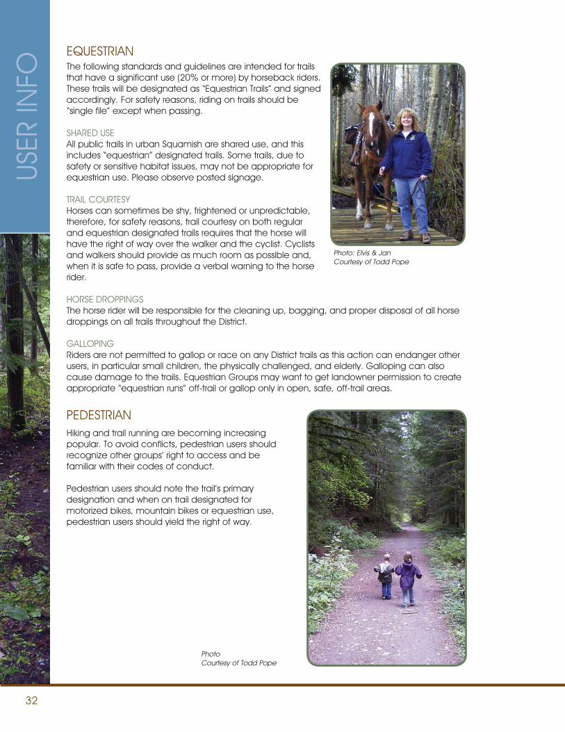
32
The following standards and guidelines are intended for trails that have a significant use (20% or more) by horseback riders. These trails will be designated as “Equestrian Trails” and signed accordingly. For safety reasons, riding on trails should be “single file” except when passing.
SHARED USEAll public trails in urban Squamish are shared use, and this includes “equestrian” designated trails. Some trails, due to safety or sensitive habitat issues, may not be appropriate for equestrian use. Please observe posted signage.
TRAIL COURTESY Horses can sometimes be shy, frightened or unpredictable, therefore, for safety reasons, trail courtesy on both regular and equestrian designated trails requires that the horse will have the right of way over the walker and the cyclist. Cyclists and walkers should provide as much room as possible and, when it is safe to pass, provide a verbal warning to the horse rider.
HORSE DROPPINGS The horse rider will be responsible for the cleaning up, bagging, and proper disposal of all horse droppings on all trails throughout the District.
GALLOPING Riders are not permitted to gallop or race on any District trails as this action can endanger other users, in particular small children, the physically challenged, and elderly. Galloping can also cause damage to the trails. Equestrian Groups may want to get landowner permission to create appropriate “equestrian runs” off-trail or gallop only in open, safe, off-trail areas.
EQUESTRIAN
Hiking and trail running are becoming increasing popular. To avoid conflicts, pedestrian users should recognize other groups’ right to access and be familiar with their codes of conduct.
Pedestrian users should note the trail’s primary designation and when on trail designated for motorized bikes, mountain bikes or equestrian use, pedestrian users should yield the right of way.
PEDESTRIAN
Photo: Elvis & JanCourtesy of Todd Pope
PhotoCourtesy of Todd Pope
USER
INFO
33
USER INFO
LIMITATIONSFor safety and maintenance reasons there is limited access to trails for motorized vehicles with the exception of maintenance/service vehicles and battery powered wheelchairs and carts. Other motorized vehicles may be operated only on “specified” shared use trails within certain areas and warning signs to the area must be posted at all access points. Negotiations are currently underway to improve access for off-road motorcycles.
The OFF-ROAD VEHICLE BYLAW NO. 1716, 2002 and amendments is the current District of Squamish bylaw related to off-road vehicles. A copy of the bylaw is available at the District website www.squamish.ca or at municipal hall.
DESIGNATED/SHARED TRIALS BIKE TRAILS The Park Avenue (Boulderdash) trail (in Smoke Bluffs Park) is an example of a designated trials bike trail. It will be “shared use” with appropriate warning signage, posted trail courtesies and degree of difficulty markings. Almost all Trials Bike shared trails will, by nature of the use and degree of physical challenge, have a “difficult” or “very difficult” rating. The same construction, maintenance, and inspection standards will apply to these trails as the Mountain Bike Standards. Some trails, or portions of trails, will also be designated (signed/marked) as permitting Trials Bike access.
On designated motorized bike trails the motorized bike will have the right of way and approaching hikers and mountain bikers should step aside and wave the bike through. The same courtesies as on regular shared trails apply.
MOTORIZED BIKE
• Learn about the area you will ride in. Contact your local user group for more information to ensure that you understand area restrictions and have permission to ride there. Get maps of the area, and stay on the designated trails
• Contact the SDBA for your BCORMA Trail Pass.
• Respect the rights of all recreationists to enjoy the beauty of the outdoors. Respect public and private property.
• Park considerately, taking no more space than needed, without blocking other vehicles and without impeding access to trails.
• Keep your dirt bike quiet – spark arresters mandatory and 96 DB noise limits.
• Obey trail markers and closure signs. There are many reasons why an area may be closed, if it is posted as closed, stay out.
• Respect designated areas, trail-use signs and established trails.
• Realize that destination objective and travel speed should be determined by your equipment, ability, the terrain, weather, and the traffic on the trail.
• Be courteous to other recreationists you may meet on the trail. Yield the right-of-way to traffic moving uphill. Pull off the trail and stop your engine for horses. Slow down and use caution when approaching another.
• When stopping do not block the trail.
• Pack out everything you packed in and do not litter.
• When talking to another trail user, take your helmet off. The helmet can make you appear to be intimidating and unfriendly. Be friendly and don’t interfere with or harass others. Recognize that people judge all trail users by their actions.
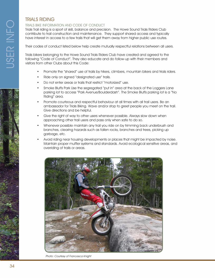
34
TRIALS BIKE INFORMATION AND CODE OF CONDUCTTrials Trail riding is a sport of skill, balance and precision. The Howe Sound Trials Riders Club contribute to trail construction and maintenance. They support shared access and typically have interest in access to a few trails that will get them away from higher public use routes.
Their codes of conduct listed below help create mutually respectful relations between all users.
Trials bikers belonging to the Howe Sound Trials Riders Club have created and agreed to the following “Code of Conduct”. They also educate and do follow-up with their members and visitors from other Clubs about this Code:
• Promote the “shared” use of trails by hikers, climbers, mountain bikers and trials riders.
• Ride only on signed “designated use” trails.
• Do not enter areas or trails that restrict “motorized” use.
• Smoke Bluffs Park Use the segregated “put in” area at the back of the Loggers Lane parking lot to access “Park Avenue/Boulderdash”. The Smoke Bluffs parking lot is a “No Riding” area.
• Promote courteous and respectful behaviour at all times with all trail users. Be an ambassador for Trials Biking. Wave and/or stop to greet people you meet on the trail. Give directions and be helpful.
• Give the right of way to other users whenever possible. Always slow down when approaching other trail users and pass only when safe to do so.
• Whenever possible maintain any trail you ride on by trimming back underbrush and branches, clearing hazards such as fallen rocks, branches and trees, picking up garbage, etc.
• Avoid riding near housing developments or places that might be impacted by noise. Maintain proper muffler systems and standards. Avoid ecological sensitive areas, and overriding of trails or areas.
TRIALS RIDING
Photo: Courtesy of Francesca Knight
USER
INFO
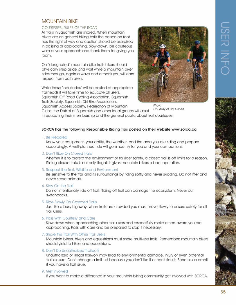
35
USER INFO
COURTESIES, RULES OF THE ROADAll trails in Squamish are shared. When mountain bikers are on general hiking trails the person on foot has the right of way and caution should be exercised in passing or approaching. Slow-down, be courteous, warn of your approach and thank them for giving you room.
On “designated” mountain bike trails hikers should physically step aside and wait while a mountain biker rides through, again a wave and a thank you will earn respect from both users.
While these “courtesies” will be posted at appropriate trailheads it will take time to educate all users. Squamish Off Road Cycling Association, Squamish Trails Society, Squamish Dirt Bike Association, Squamish Access Society, Federation of Mountain Clubs, the District of Squamish and other local groups will assist In educating their membership and the general public about trail courtesies.
MOUNTAIN BIKE
1. Be Prepared Know your equipment, your ability, the weather, and the area you are riding and prepare
accordingly. A well-planned ride will go smoothly for you and your companions.
2. Don’t Ride On Closed Trails Whether it is to protect the environment or for rider safety, a closed trail is off limits for a reason.
Riding closed trails is not only illegal; it gives mountain bikers a bad reputation.
3. Respect the Trail, Wildlife and Environment Be sensitive to the trail and its surroundings by riding softly and never skidding. Do not litter and
never scare animals.
4. Stay On the Trail Do not intentionally ride off trail. Riding off trail can damage the ecosystem. Never cut
switchbacks.
5. Ride Slowly On Crowded Trails Just like a busy highway, when trails are crowded you must move slowly to ensure safety for all
trail users.
6. Pass With Courtesy and Care Slow down when approaching other trail users and respectfully make others aware you are
approaching. Pass with care and be prepared to stop if necessary.
7. Share the Trail With Other Trail Users Mountain bikers, hikers and equestrians must share multi-use trails. Remember: mountain bikers
should yield to hikers and equestrians.
8. Don’t Do Unauthorized Trailwork Unauthorized or illegal trailwork may lead to environmental damage, injury or even potential
trail closure. Don’t change a trail just because you don’t like it or can’t ride it. Send us an email if you have a trail issue.
9. Get Involved If you want to make a difference in your mountain biking community get involved with SORCA.
SORCA has the following Responsible Riding Tips posted on their website www.sorca.ca
PhotoCourtesy of Pat Gilbert
36
SPECIAL EVENT ACCESS/APPROVAL TO USE TRAILS
GENERALThe District of Squamish encourages and supports special events in the community. The intent of the application process is to foster and enable good planning and positive experiences for the organizing groups and the general public. The process is designed to enhance the event by improving communications and clearly outlining expectations.
APPLICATION PROCESSAll community special events that utilize trails, both internal and external, must go through an application process with the District of Squamish. There are standard forms to be filled out by each event organizer. The intent of this process is to monitor, control and protect the trails from overuse, user conflicts, and potential abuse of the resources and facilities.
The process will also be used to inform and educate the users and the public, and in some cases enhance trail maintenance or amenities. The Application Form will require event information (including date, time, type of event, anticipated number of users, route description and mapping, cost for participants, and whether or not it is a private, public, or commercial event, etc.).
REQUIREMENTSDepending on the complexity of the event, the application may involve a site visitation, safety inspections, event reports, and a list of requirements (or expectations list) for the event organizers.
There may also be a trail/amenity/facility cleanup requirement following the event. Major or commercial events may be required to complete a consultative process with specific trail community groups. Some events may require Council approval.
APPROVAL PROCESS AND TIMEDepending on the complexity, sensitivity or history of the event, the process can be relatively simple or the consultative process can take some time. It is important that all first-time events get their applications into the Trail Coordinator as soon as possible (even if it is only in the planning stages).
Major events or commercial events should apply a minimum of two months in advance of the event. Late applications may not be approved.
USER
INFO
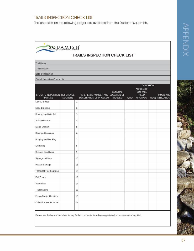
37
TRAILS INSPECTION CHECK LIST
Trail Name
Trail Location
Date of Inspection
Overall Inspection Comments
CONDITION
SPECIFIC INSPECTIONFINDINGS
REFERENCENUMBERS
REFERENCE NUMBER AND DESCRIPTION OF PROBLEM
GENERALLOCATION OF
PROBLEM GOOD
ADEQUATEBUT WILL
NEEDUPGRADE POOR
IMMEDIATEMITIGATION
Litter/Garbage 1
Edge Brushing 2
Brushes and Windfall 3
Safety Hazards 4
Slope Erosion 5
Riparian Crossings 6
Bridging and Decking 7
Sightlines 8
Surface Conditions 9
Signage in Place 10
Hazard Signage 11
Technical Trail Features 12
Fall Zones 13
Vandalism 14
Trail Braiding 15
Fence/Barrier Condition 16
Cultural Areas Protected 17
Please use the back of this sheet for any further comments, including suggestions for improvement of any kind.
TRAILS INSPECTION CHECK LISTThe checklists on the following pages are available from the District of Squamish. A
PPEND
IX
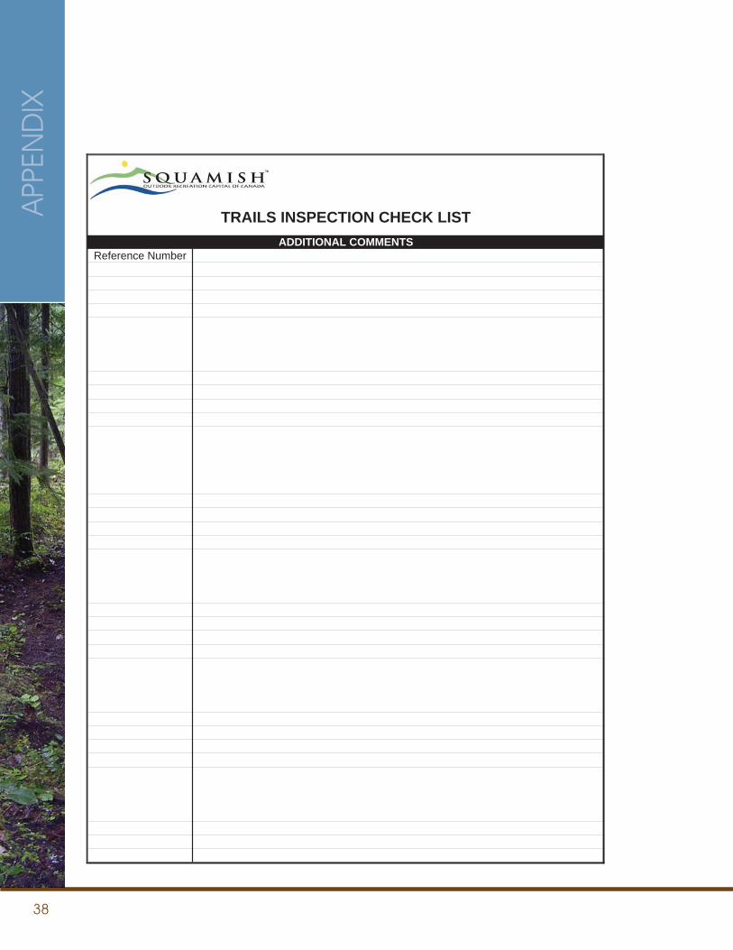
38
APP
END
IX
TRAILS INSPECTION CHECK LISTADDITIONAL COMMENTS
Reference Number
39
RESOURCESTRAIL MAPS Current Trail Maps are available at the Squamish Municipal Hall, the Squamish Adventure Center and local businesses for a small fee. Net proceeds from these sales go to the Squamish Trails Society for further work on the trail system.
The interactive trails map available online through www.squamish.ca (follow links to trails) contains excellent information. Users can search by area, difficulty, and by trail type (ex: hiking, SDBA, access trails).
FORMS (Available through the District of Squamish): • Trail Safety/Maintenance Inspection Form
• Special Event Application Form for Trail Use
OFFROAD VEHICLE BYLAW NO. 1716, 2002 – Available through Municipal Hall or online at www.squamish.ca. District of Squamish Watercourse Regulations. Available through Municipal Hall.
British Columbia Ministry of Forests and Range website:www.gov.bc.ca/for
British Columbia Ministry of Forests and Range statutes section 57 proposal applications:www.tca.gov.bc.ca/sites_trails/managing/Section_57.htm
Squamish Adopt-a-Trailwww.adoptatrail.ca
RESOURC
ES

40
41
REFERENCESCascade Environmental Resource Group Ltd. Squamish Mountain Bike Management Plan. July 5, 2005.
Catalyst Community and Resort Planning. Corridor Recreation Trail Management Plan. September 17, 2008.
British Columbia: Trails Strategy for British Columbia.
British Columbia Ministry of Forests. 2002 Forest and Range Practices Act.
British Columbia Ministry of Tourism, Sport and the Arts. Sea to Sky Corridor Recreation Trail Strategy. April 2008.
Catalyst Community and Resort Planning. Corridor Recreation Trail Management Plan. September 17, 2008.
District of Squamish Watercourse Regulations.
International Mountain Biking Association. Trail Solutions: IMBA’S Guide to Building Sweet Singletrack. 2004.
Resort Municipality of Whistler. Whistler Trail Standards Environmental and Technical Trail Features.

37955 Second Avenue. Squamish BC Canada V8B 0A3604.892.5217
WWW.SQUAMISH.CA


