Enhancing the skills of the technical staff belonging to the Department of Agricultural Land Management (DALaM) in Lao PDR requires Land Resource Information Management Systems (LRIMS) implementation. As such, the
Training Needs Assessment (TNA) project is the first step towards achieving this target. The aim of the TNA is to develop and consequently transfer knowledge and skills of basic and advanced GIS training packages and relevant activities that will generate the technical capacities required to support the requirements of the SAMIS project; concomitantly, this will ensure that DALaM staff can effectively run and maintain the LRIMS. This document describes the conditions for the training assessment, not only for implementation of the LRIMS but also for developing the capacity of DALaM staff. DALaM staff need to develop expertise in terms of remote sensing, GIS technologies and any other relevant aspects of the SAMIS project. In particular, the technical staff of the DALaM GIS unit are responsible for this mission. This document is a roadmap for the SAMIS project and DALaM’s strategic plan to develop staff capacity in a systematic way for the future.
Abstract »iii
Contents »iii …………….. Abstract vi …………… Tablesvii ……………. Abbreviations and acronyms
1 …………… INTRODUCTION1 ……………………… 1.1 Background of the Strengthening Agro-climatic Monitoring and Information Systems (SAMIS) project2 ……………………… 1.2 Goal and objectives3 …………… APPROACH TO THE TRAINING NEEDS ASSESSMENT5 …………… RESULTS AND DISCUSSION5 ……………………… 3.1 Strategic weaknesses of the geographic information system (GIS) unit in the context of SAMIS requirements7 ……………………… 3.2 Necessary conditions9 ……………………… 3.3 Capacity development tools to deliver required products9 ………………………............... 3.3.1 General training for basic GIS information (Group 1)10 ………………………............ 3.3.2 Intermediate and advanced training on GIS (Group 2)15 ………………………............ 3.3.3 Advanced overseas training for enhancing GIS units16 …………. CONCLUSIONS
v
7 Table 1 Necessary conditions to mitigate Department of Agricultural Land Management weaknesses9 Table 2 Training needs for remote sensing and GIS technologies (basic module)11 Table 3 Training needs for remote sensing and GIS technologies (intermediate module)12 Table 4 Training needs for remote sensing and GIS technologies (advanced module)15 Table 5 Overseas training
Tables»vi
Abbreviationsand acronyms
»AEZ agro-ecological zoningALUPC Agricultural Land Use Planning CentreCAS Center for Agricultural StatisticsCBDS Geo-Spatial Information Systems MAF BranchDALaM Department of Agricultural Land ManagementDCCM Department of Climate Change ManagementDMH Department of Meteorology and HydrologyFAO Food and Agriculture Organization of the United NationsGEF Global Environment FacilityGIS geographic information systemIT information technologyLCCS Land Cover Classification SystemLRIMS Land Resources Information Management SystemLUT Land Utilization TypeMAF Ministry of Agriculture and ForestryMoNRE Ministry of Natural Resources and EnvironmentNAEZ National Agro-Ecological ZoningNAFRI National Agriculture and Forestry Research InstituteRS remote sensingSAMIS Strengthening Agro-climatic Monitoring and Information Systems SAR Agriculture Production Systems at RiskSAVA Socio-Agricultural Vulnerability AnalysisTNA Training Needs Assessment
vii
1
1»
The Training Needs Assessment (TNA) is a major activity of the first year of Com-ponent 2 under the Strengthening Agro-Climatic Monitoring and Information Systems (SAMIS) project. It aims at developing technical knowledge and skills in
remote sensing (RS) and geographic information system (GIS) technologies as well as database management, information technology (IT) capacities, Land Resource Informa-tion Management Systems (LRMIS), agro-ecological zoning (AEZ), Socio-Agricultural and Vulnerability Analysis (SAVA) and agricultural production Systems at Risk (SAR) for De-partment of Agricultural Land Management (DALaM) staff, especially the GIS unit. This project will support the DALaM staff responsible for implementing Component 2 and help them to carry out and maintain this system in the future.
1.1 Background of the SAMIS projectThe SAMIS project is funded through the Global Environment Facility (GEF) in partner-ship and with co-funding from governments, partner programmes and donors at country and regional levels. The project is executed by the Food and Agriculture Organization of the United Nations (FAO). The goal is to enhance national- and provincial-level monitor-ing, analysis, communication and use of agrometeorological data and information for de-cision-making in relation to agriculture and food security, and to improve monitoring and analysis of agricultural production systems by strengthening LRMIS and AEZ to support agricultural policies and climate change adaptation. This project will improve adaptation to climate change and food security in Lao PDR. It has the following three components:
1. Agroclimate monitoring, analysis and advisory systems; 2. LRMIS and National Agro-Ecological Zoning (NAEZ); and
3. Knowledge management and dissemination.
INTRODUCTION
2
1.2 Goal and objectivesThe overall goal of this project is to develop capacity in the GIS unit and relevant partners (if required) to support the requirements of the SAMIS project, especially in Component 2 (LRMIS and NAEZ). The specific objectives are:
1. To develop and transfer knowledge and skills on basic and advanced GIS packages, IT capacities and relevant activities to support the requirements of the SAMIS project (LRIMS, NAEZ, SAVA, land cover) among staff from DALaM, especially for the GIS unit.
2. To ensure continuous use of introduced tools and methods among DALaM staff for sustainable and effective running and maintenance of the LRMIS.
3
2»APPROACH TO THE TRAINING NEEDS ASSESSMENT
The SAMIS project was initiated in the middle of 2017 and the subsequent Letter of Agreement was signed between FAO and DALaM on 5 April 2018 for the provision of support to the LRIMS of Component 2. Conceptually,
the project began when an overview of the SAMIS project, Component 2 activities, was presented by Monica Petri, Project Coordinator, FAO in Laos on 28 July 2017. In addition, Gianluca Franceschini GIS/RS Technical Coordinator, Geo-Spatial In-formation Systems Branch (CBDS) from FAO headquarters in Rome, Italy travelled to Lao PDR to explain the details of Component 2 activities to DALaM’s technical team at a training course conducted on 8 and 9 September 2017 at DALaM. The training covered the following topics:
• An integrated system for LRIMS, NAEZ and SAVA;• From global to national AEZ;• Introduction to metadata and reporting metadata;• LRIMS modules;• Data requirements; and• Land cover mapping.
4
Later, Ece Aksoy (CBDS) conducted a training course from 1 to 8 May 2018 at DALaM’s GIS unit to initiate the following technical capacity development activities:
• Data preparation;• Projection systems and technical advice on best spatial projection for
harmonizing LRIMS data;• Theoretical training on metadata standards;• Theoretical baseline AEZ study and sharing of best global practices on AEZ estab-
lishment;• An analytical exercise using a Pakistan case study (crop suitability maps, agrocli-
matic/AEZ and agro-economic zoning); and• Land utilization type (LUT) modules in LRIMS and AEZ.
The present TNA was developed in line with the consultants’ meeting on LRIMS and AEZ at DALaM on 11 June 2018 and discussion among GIS staff on 16 August 2018. It targets capacity development of DALaM staff, especially GIS staff, to support the prepa-ration and implementation of the LRIMS and other tasks under DALaM’s responsibility for addressing Component 2 of the SAMIS project.
This TNA determines the training needs for Component 2 pertaining to DALaM staff (section 3.2) and the procedure for implementing the training process. The TNA is di-vided into in-country and overseas training needs to ensure that DALaM staff benefit from the project training process effectively.
5
3»RESULTS AND DISCUSSION
3.1 STRATEGIC WEAKNESSES OF THE GIS UNIT IN THE CONTEXT OF SAMIS REQUIREMENTS
Suboptimal understanding of GIS use among government staff working in the agriculture: DALaM has agreed to take the lead in data storage and sharing at the Ministry of Agriculture and Forestry (MAF) level.
However, this can only be accomplished if DALaM staff have at least basic understanding of GIS. This also includes staff at the National Agriculture and Forestry Research Institute (NAFRI), Center for Agricultural Statistics (CAS), Department of Meteorology and Hydrology (DMH), Department of Climate Change Management (DCCM), the E-government Centre and among provincial authorities (MAF and the Ministry of Natural Resources and Environment [MoNRE]).
The GIS unit has no leadership role: For the past few years the GIS unit has mostly provided a service role for catering to government or project requests. Instead, the GIS unit should have a recognized leadership role in the MAF and at the national level, but this is not the case. Consequently, staff self-esteem has been affected adversely. The role of the GIS unit can be strengthened via training on innovative technologies.
Suboptimal knowledge of advanced GIS tools: As DALaM was established in 2012, it is a young organization compared to the departments or institutes under the MAF. DALaM’s mandate is to undertake: 1) soil surveys and agricultural land-use planning; 2) maintenance, improvement, demonstration and adoption of appropriate technology; and 3) agricultural land management. Under the Agricultural Land Use Planning Center (ALUPC), DALaM has established a GIS unit with varying degrees of technical knowledge and skills in geospatial sciences. However, currently, DALaM still lacks GIS expertise in specific capacities such as modelling, GIS database management, programming and so forth. Therefore, this TNA will
6
help the GIS unit to acquire further expertise in GIS at different levels, thus not only supporting the Component 2 mission, but also government activities. This will assist with monitoring of land-use/land-cover changes in terms of agricultural land management, land suitability evaluation or modelling, disaster analysis and other activities.
Suboptimal English language capacity: One of the GIS unit’s main constraints is weak English language capacity in the contexts of daily working routines, reading software or manuals and communication with international experts. This undermines staff confidence and does not inspire our colleagues to work with the unit; it also inhibits information searching and accessing manuals or packages from Web sites for new information on geospatial science. In addition, suboptimal English language skills hinder opportunities for independent study. Improving English language skills will help to improve course comprehension during the period of this project.
Suboptimal knowledge of innovative GIS tools: The team at DALaM is not accustomed to working with innovative technologies and accessing the latest versions of software and hardware. This is because the GIS unit has had recurrent problems with infrastructure, not only with regard to building quality and provision of PCs for staff, but also poor internet connections. In a world that is becoming more connected daily, the staff cannot keep pace with innovation developments without reliable Internet access. Training on innovative technologies will allow them to consolidate these skills by and after the end of the project, for example in the map-making process, which can be concluded in one day rather than the months it took in the past. However, this is contingent on the provision of fast and dependable internet access.
Suboptimal policy, data management and data-sharing capacity: Data-sharing cooperation by all parties concerned in the context of natural resource information production is extremely limited. There is a need to raise awareness about the importance of sharing information on planning and decision-making by all relevant parties beyond the DALaM team per se, or the data produced by the project will not be used. In addition, by being able to focus on relevant planning on information use for policy-making the DALaM team will become a key unit at the national level.
Lack of knowledge about standard GIS methodologies: DALaM has been responsible for creating agricultural maps over the last few years. The general capacities for satellite image interpretation are available. However, there has not been any training about standardized procedures. The use of globally recognized processes is key for positive future use of the GIS capacities that will be developed by the project.
Suboptimal knowledge of Web tools and application (app) management: Via SAMIS, the DALaM GIS unit has accepted the challenge of hosting multiple data inputs from across sectors. Selected staff at DALaM will need to develop advanced capacity for server, web and app management in order to be able to maintain the LRIMS beyond the life of the project.
7
Table 1 presents the necessary conditions for addressing the weaknesses cited.
Table 1 Necessary conditions to mitigate DALaM weaknesses
Identified weaknesses Solutions
Suboptimal understanding of GIS use among government staff working in the agriculture sector
Other entities beyond DALaM need to be trained in GIS technology.
Develop DALaM capacity to manage deci-sion-making apps.
The DMH should be included in this training process as it produces agrometeorology infor-mation without being able to deliver results at the map-making level.
The GIS unit has no leadership role DALaM needs to become an authority on the subject and employ high-level GIS experts.
DALaM needs to be a recognized training agent for training multiple teams in Lao PDR on behalf of the MAF.
Suboptimal knowledge of advanced GIS tools DALaM needs to become an authority on GIS and employ high-level GIS experts.
Advanced capacity needs to be propagated among the team. The entire team needs to be able to fulfil multiple tasks with an array of sophisticated GIS tools.
Suboptimal English language capacity All DALaM staff should be able to read English. Also, they should be able to take part in basic discussions that are conducted in English.
3.2 NECESSARY CONDITIONS
8
Identified weaknesses Solutions
Suboptimal knowledge of innovative GIS tools In order to be a recognized authority at the na-tional level, the GIS team needs to be educated in and ready to adopt innovative technologies. A reliable Internet connection beyond the life of the project is imperative for sustaining throughput.Understanding innovations is essential for GIS staff to continue to study independently.
Suboptimal policy, data management and da-ta-sharing capacity
In order to guide planning and policy-making, the GIS unit staff need to be trained in relevant modelling exercises.Also, the staff need to be informed about the value of data sharing and be able to explain technically what this can generate.Finally, selected senior staff should be able to present (simply) complex model information at the policy level. This also includes under-standing policy-makers’ needs and requests.
Suboptimal knowledge of standard GIS methodologies
Standard methodology, such as land-cover mapping with the Land Cover Classifica-tion System (LCCS), which is globally rec-ognized, must be understood by GIS unit technicians.
Suboptimal knowledge of Web tools and app management
Selected staff must have the capacity to maintain and update the LRIMS on an ongoing basis.
To ensure the training programme achieves its goal, it will be divided into two groups: Group 1 for basic GIS packages and Group 2 for intermediate and advanced GIS packages.
9
3.3.1 General training for basic GIS information (Group 1)This training targets the minimal knowledge on GIS. In this context, other entities beyond DALaM need to understand the general theory of GIS and tool application. This includes the capacity to manage a decision-making app by administrative staff and by senior decision-makers. The DMH is also part of this group as it produces agrometeorological information without being able to deliver results at the map-making level.
As such, DALaM needs to become an authority on the subject and employ high-level GIS experts. Moreover, DALaM needs to be a recognized training agent for training multiple teams in Lao PDR on behalf of the MAF.
Group 1 will comprise participants from NAFRI, CAS, DMH, DCCM, the E-government Centre and decentralized authorities (MAF and MoNRE). The training can be conducted in the Lao language by DALaM experts. Training needs are listed in Table 2.
Table 2 Training needs for remote sensing and GIS technologies (basic module)
3.3 CAPACITY DEVELOPMENT TOOLS TO DELIVER REQUIRED PRODUCTS
Courses Description Trainees
Training entity (teachers or professors) When
Working with ArcGIS
• Display data• Querying the database• Working with the selec-tion tools• Working with spatial data• Working with tables• Editing attribute data• Working with georefer-enced data• Presenting data
DMH staff of Component 1 (12 people)
DALaM 2019
10
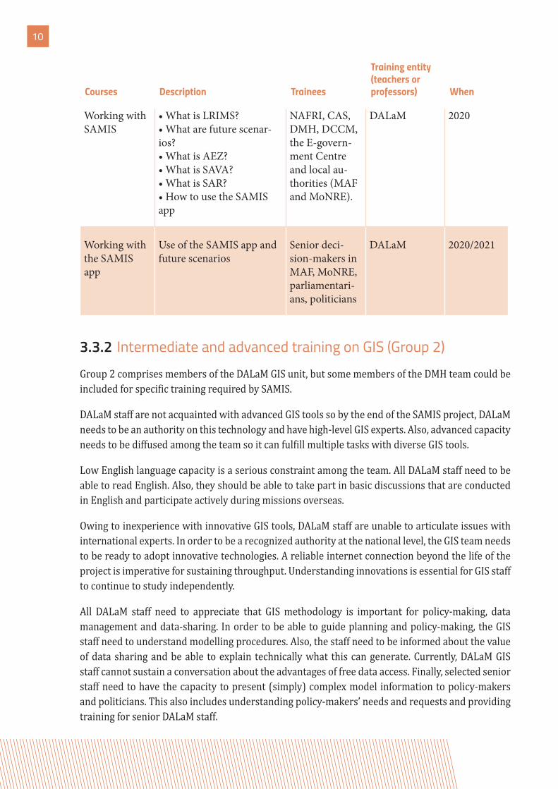
Working with SAMIS
• What is LRIMS?• What are future scenar-ios?• What is AEZ?• What is SAVA?• What is SAR?• How to use the SAMIS app
NAFRI, CAS, DMH, DCCM, the E-govern-ment Centre and local au-thorities (MAF and MoNRE).
DALaM 2020
Working with the SAMIS app
Use of the SAMIS app and future scenarios
Senior deci-sion-makers in MAF, MoNRE, parliamentari-ans, politicians
DALaM 2020/2021
3.3.2 Intermediate and advanced training on GIS (Group 2)Group 2 comprises members of the DALaM GIS unit, but some members of the DMH team could be included for specific training required by SAMIS.
DALaM staff are not acquainted with advanced GIS tools so by the end of the SAMIS project, DALaM needs to be an authority on this technology and have high-level GIS experts. Also, advanced capacity needs to be diffused among the team so it can fulfill multiple tasks with diverse GIS tools.
Low English language capacity is a serious constraint among the team. All DALaM staff need to be able to read English. Also, they should be able to take part in basic discussions that are conducted in English and participate actively during missions overseas.
Owing to inexperience with innovative GIS tools, DALaM staff are unable to articulate issues with international experts. In order to be a recognized authority at the national level, the GIS team needs to be ready to adopt innovative technologies. A reliable internet connection beyond the life of the project is imperative for sustaining throughput. Understanding innovations is essential for GIS staff to continue to study independently.
All DALaM staff need to appreciate that GIS methodology is important for policy-making, data management and data-sharing. In order to be able to guide planning and policy-making, the GIS staff need to understand modelling procedures. Also, the staff need to be informed about the value of data sharing and be able to explain technically what this can generate. Currently, DALaM GIS staff cannot sustain a conversation about the advantages of free data access. Finally, selected senior staff need to have the capacity to present (simply) complex model information to policy-makers and politicians. This also includes understanding policy-makers’ needs and requests and providing training for senior DALaM staff.
Courses Description Trainees
Training entity (teachers or professors) When
11
Standard methodology, such as land-cover mapping with the LCCS, which is globally recognized, must be understood by GIS unit technicians. Finally, selected staff need to be able to maintain and update the LRIMS on an ongoing basis.
Tables 3 and 4 show the training needs for remote sensing and GIS technologies in the above-mentioned contexts.
Table 3 Training needs for remote sensing and GIS technologies (intermediate module)
English training • Basic level DALaM (13 staff) English school 2018
English training • Intermediate level DALaM (13 staff) English school 2019
12
Tabl
e 4
Trai
ning
nee
ds fo
r re
mot
e se
nsin
g an
d GI
S te
chno
logi
es (
adva
nced
mod
ule)
Cour
ses
Topi
csTr
aine
esTr
aini
ng e
ntity
(tea
cher
s or
prof
esso
rs)
Whe
n
Agr
icul
tura
l lan
d m
oni-
torin
g • C
alcu
latin
g an
nual
crop
ex
tent
by
usin
g re
mot
e se
nsin
g an
d G
IS te
chni
ques
Sele
cted
DA
LaM
staff
End
of 2
019,
afte
r th
e pr
oduc
tion
of th
e fir
st la
nd-c
over
map
Land
suita
bilit
y m
odel
ling
• AEZ
usin
g A
rcG
ISD
ALa
M (2
mod
elle
rs
and
4 st
aff m
embe
rs
for o
ne y
ear)
FAO
cons
ulta
ntM
ultip
le tr
aini
ng
over
the
proj
ect
Ass
essm
ent o
f are
as se
nsi-
tive
to la
ndsli
de ri
sk• G
eom
orph
olog
y st
udie
s pl
us fl
oodi
ng im
pact
DA
LaM
To b
e di
scus
sed
Nat
ural
Disa
ster
Re-
sear
ch C
ente
r – In
done
-sia
To b
e di
scus
sed
Ass
essm
ent o
f floo
ding
an
d dr
ough
t vul
nera
bilit
y • H
ydro
logy
stud
ies f
or
early
war
ning
syst
ems a
nd
risk
man
agem
ent
DA
LaM
To b
e de
fined
To b
e di
scus
sed
Ass
essm
ent o
f the
impa
cts
of cl
imat
e ch
ange
on
agri-
cultu
ral p
rodu
ctiv
ity
• AEZ
usin
g A
rcG
ISD
ALa
MFA
O co
nsul
tant
Ove
r the
pro
ject
13
Cour
ses
Topi
csTr
aine
esTr
aini
ng e
ntity
(tea
cher
s or
prof
esso
rs)
Whe
n
Land
-cov
er m
appi
ng
• Im
age
clas
sifica
tion
inte
r-pr
etat
ion
accu
racy
ass
ess-
men
t
DA
LaM
(4 st
aff m
em-
bers
for o
ne y
ear)
FAO
cons
ulta
ntTh
eory
and
pra
ctic
e in
201
8
Fina
lizat
ion
in 2
019
Geo
-info
rmat
ics t
echn
ol-
ogy
for e
stim
atin
g fo
rest
ry
carb
on st
ocks
• To
be d
iscus
sed
DA
LaM
DO
F/M
AF
2019
/202
0
Dow
nloa
ding
free
sate
llite
im
ages
from
web
site
s• T
o be
disc
usse
dD
ALa
MN
atio
nal o
r int
erna
tiona
l co
nsul
tant
or fi
rm20
19/2
020
Cre
atin
g an
d m
anag
ing
the
met
adat
a • M
etad
ata
theo
ry
• Use
in A
rcG
IS
DA
LaM
FAO
cons
ulta
nt
Nat
iona
l or i
nter
natio
nal
cons
ulta
nt o
r firm
2019
/202
0
Use
of s
erve
rs a
nd th
e LR
IMS
• App
licat
ion
stru
ctur
e an
d co
mpo
nent
s
• Use
of t
he se
rver
or d
ata
clou
ds
• Ins
ertin
g da
ta in
LRM
IS
(tab
les,
phot
os, v
ideo
s, im
-ag
es o
r GRI
D w
ith le
gend
)
• How
to in
sert
met
adat
a in
th
e LR
MIS
• LRM
IS m
aint
enan
ce
DA
LaM
PHO
ENIX
com
pany
2018
/201
9
14
Cour
ses
Topi
csTr
aine
esTr
aini
ng e
ntity
(tea
cher
s or
prof
esso
rs)
Whe
n
Inte
grat
ed a
gric
ultu
ral
land
scap
e-le
vel p
lann
ing
and
man
agem
ent
• Lan
d m
anag
emen
t at
mul
tiple
scal
es, m
ultip
le
func
tions
and
mul
tiple
st
akeh
olde
r man
agem
ent
To b
e de
fined
2020
/202
1
Polic
y, da
ta m
anag
emen
t an
d da
ta-s
harin
g ca
paci
ty• D
ata
man
agem
ent
for p
olic
y-m
aker
s, da
ta co
mm
unic
atio
n,
data
repr
esen
tatio
n,
info
rmat
ion-
shar
ing
theo
ry,
open
sour
ce d
ata
acce
ss
DA
LaM
To b
e de
fined
2020
Soci
oagr
icul
tura
l ass
ess-
men
tsD
ALa
M +
oth
er
entit
ies o
ffici
ally
re
spon
sible
Inte
rnat
iona
l ent
ity20
19/2
020
Long
-ter
m h
ands
-on
trai
ning
by
an in
tern
atio
n-al
exp
ert i
n A
EZ
The
pres
ence
of a
n in
tern
atio
nal e
xper
t wou
ld
ensu
re co
ntin
ued
use
of
Engl
ish a
nd w
orki
ng at
an
adva
nced
leve
l
To b
e de
fined
2018
–202
0
15
3.3.3 Advanced overseas training for enhancing GIS units
Ideally, members of the GIS unit could study within teams and in other countries with different technical focus. The selection of training participants will be made over the time. However, there needs to be a clear focus on English-speaking countries or in countries where English as a second language is well developed.
Table 5 Overseas training
Targets Number of trainees Location/trainers
AEZ specialized entity 2 To be defined
Group field visit 6 In a country where land-use planning employs AEZ
Short training in advanced GIS crop modelling
“-” To be defined
Master programmes “-” The project can interact with other donors willing to sup-port specific training abroad
16
This project comprises a multiple training needs assessment for enhancing the capacity of DALaM staff and other partners relevant to the SAMIS project. This task is a necessary
and important undertaking for capacity development. In order to achieve our goals, the capacity development exercise is an essential task that we need to combine with the capacity development of technical staff simultaneously to ensure that this strategy will support DALaM planned targets.
GIS is an important tool to organize, manage and distribute geographic information in many fields. The identification of topics for capacity development is the first step towards achieving our ultimate goals. However, there are multiple dynamics to consider as well as the implementation of Component 2 (LRIMS, NAEZ, SAVA) and other tasks. As such, DALaM staff members have to study industriously at training courses and with international experts; the trainings could be held at DALaM or overseas and will also have the benefits of boosting staff confidence and generating good results. Therefore, the preparation of tools for capacity development is an important process that should take into account the potential of the human resources who will apply them. Essentially, staff lack technical skills in remote sensing and GIS technologies and this is compounded by low capacity to communicate in English. Thus, DALaM is taking this opportunity to address the issues mentioned in order to become a national leader in GIS technology use after the end of the SAMIS project. The main capacity development tools are:
1. Continuing English language training for staff to boost their confidence in speaking, reading, report writing and interacting with international experts.
2. Training on LRIMS, AEZ, SAVA and GIS. 3. Providing guidance through general and specific manuals, handouts, leaflets and
posters on technical aspects related to the SAMIS project.4. Developing programming, modelling and management of geographic database capacity.
4»CONCLUSION
Contact information
Food and Agriculture Organization for the United Nations E-mail: [email protected]: http://www.fao.org/in-action/samis/en/128 Phone-Xay Road, Phonxay Village, Saysettha District, VIENTIANE