+ All Categories
Home > Documents > Transboundary Aquifers of the World - IGRAC · Inventory of Transboundary Groundwater, ......

Transboundary Aquifers of the World - IGRAC · Inventory of Transboundary Groundwater, ......

Date post: 23-Aug-2018
Category:
Upload: dinhminh
View: 215 times
Download: 0 times
Share this document with a friend
2
" ) " ) " ) " ) " ) " ) " ) " ) " ) " ) " ) " ) " ) " ) " ) " ) " ) " ) " ) " ) " ) " ) " ) " ) " ) " ) " ) " ) " ) " ) ! ( ! ( ! ( ! ( ! ( ! ( ! ( ! ( ! ( ! ( ! ( ! ( ! ( ! ( ! ( " ) " ) " ) " ) " ) " ) " ) " ) " ) " ) " ) " ) " ) " ) " ) " ) " ) " ) " ) " ) " ) " ) " ) " ) " ) " ) " ) " ) ! ( ! ( ! ( ! ( ! ( ! ( ! ( ! ( ! ( ! ( ! ( ! ( ! ( ! ( ! ( ! ( ! ( ! ( ! ( ! ( ! ( ! ( ! ( ! ( ! ( ! ( ! ( ! ( " ) " ) " ) ! ( ! ( " ) " ) " ) " ) " ) " ) " ) " ) " ) ! ( " ) " ) " ) " ) " ) " ) " ) " ) " ) " ) " ) " ) " ) " ) " ) " ) ! ( ! ( ! ( ! ( " ) " ) ! ( ! ( ! ( " ) " ) " ) " ) " ) " ) ! ( " ) ! ( ! ( ! ( ! ( ! ( ! ( ! ( ! ( ! ( ! ( ! ( ! ( ! ( ! ( ! ( ! ( ! ( ! ( ! ( ! ( ! ( ! ( ! ( ! ( ! ( ! ( " ) " ) " ) " ) " ) " ) " ) " ) " ) " ) " ) ! ( ! ( ! ( ! ( ! ( " ) " ) " ) " ) " ) " ) " ) " ) " ) " ) " ) " ) ! ( ! ( ! ( ! ( ! ( ! ( ! ( ! ( ! ( ! ( ! ( ! ( ! ( ! ( ! ( ! ( " ) " ) " ) " ) " ) " ) " ) " ) " ) " ) " ) ! ( " ) " ) " ) " ) " ) ! ( ! ( " ) " ) " ) ! ( ! ( ! ( ! ( ! ( ! ( ! ( ! ( ! ( ! ( ! ( ! ( ! ( ! ( ! ( ! ( ! ( ! ( ! ( ! ( ! ( ! ( ! ( ! ( ! ( ! ( ! ( ! ( ! ( ! ( ! ( ! ( ! ( ! (! ( ! ( ! ( ! ( ! ( ! ( ! ( ! ( ! (! ( ! ( ! ( ! ( ! ( ! ( ! ( ! ( ! ( ! ( ! ( ! ( ! ( ! ( ! ( ! ( ! ( ! ( ! ( ! ( ! ( ! ( ! ( ! ( ! ( ! ( ! ( ! ( ! ( ! ( ! ( ! ( ! ( ! ( ! ( ! ( ! ( " ) " ) " ) " ) " ) ! ( ! ( ! ( ! ( ! ( ! ( ! ( ! ( ! ( ! ( ! ( ! ( ! ( ! ( ! (! ( ! ( " ) ! ( " ) " ) " ) " ) " ) 1CB 3CB 4CB 8N 7N 3N 30S 2S 11S 11N 10S 17S 21N 1S 1N 18S 18C AS132 AS133 AS134 AS135 AS137 AS136 AS3 AF62 AF39 AF36 AF15 AF2 AF4 AF78 AF74 AF76 AF77 AS120 AS102 EU29 EU126 EU125 EU124 EU130 EU128 EU129 EU127 EU123 EU11 AS8 EU281 AS4 AF7 AS152 EU10 AS156 AS139 AS127 AS131 AS141 AS130 AS140 AS1 AS128 AS129 AS142 AS143 AS126 AS124 2CB 9N 8S 7S 7C 6S 6N 5S 5N 4S 4N 3S 2N 29S 28S 27S 26S 25S 24S 23S 22S 16S 16N 15S 15N 14S 14N 13S 13N 12S 12N 10N 21S 9S 20S 19S 17N AF32 AF31 AF14 AF8 AF1 AF58 AF71 AF72 AS86 AS83 AS89 AS90 AS82 AF38 AF44 AF45 AF53 AF33 AF34 AF40 AF5 AF12 AF3 AF16 AF17 AF19 AF21 AF20 AF27 AF9 AF18 AF11 AF6 AF80 AF75 AF70 AF79 AF68 AS104 AS87 AS138 AS98 AS103 AS105 AS91 AS118 AS119 AS93 AS92 AS81 AS80 AS116 AS117 AS79 AS113 AS10 AS115 AS114 AS37 AS35 AS101 AS100 AS77 AS31 EU22 AS2 AF51 AF82 AF81 AF23 AF22 AF25 AF26 AF29 AF42 AF47 AF49 AF52 AF63 AF83 AF10 AF13 AF24 AF43 AF46 AF59 AF61 AF73 20N AS71 AF54 AF56 AF64 19N 18N AS150 AS72 AS11 AS76 AS36 AS47 AS74 AS19 AS97 AS78 AS151 AS153 AS96 AS95 AS94 AS111 AS110 AS109 AS108 AS106 AF69 AS125 AF48 AF88 EU283 AS88 AS154 AS155 EU144/ EU179 EU6 EU138 EU182 EU139 EU280 EU87 EU94 EU112 Special Edition for the 7 World Water Forum 2015 Scale 1 : 50 000 000 Scale 1 : 135 000 000 Transboundary Aquifers of the World 180° 120°E 90°E 60°E 30°E 30°W 60°W 90°W 120°W 150°W 30°S 60°N 180° A B C D E F G H I J K L 1 2 3 4 5 60°S 30°N 150°E Prepared by IGRAC Base maps Country borders: ESRI World Country Generalized layer (April, 2014) Rivers and lakes: ESRI (2009) Map projection Robinson projection, geographic coordinates, spheroid WGS84, longitude of central meridian 0º. © IGRAC, March 2015 Released under the Creative Commons licence. Attribution Non-Commercial Share Alike. lakes aquifer/groundwater body label AB12 1 2 3 4 5 Legend transboundary aquifers lakes country boundary ice cap tundra subarctic humid continental humid subtropical marine mediterranean tropical dry tropical wet semi-arid arid highlands Legend transboundary aquifers lakes country boundary Legend Ocurrence and extent aquifer groundwater body overlapping area " ) small aquifer ! ( small groundwater body TBAs type of delineation confirmed boundary approximate boundary th Geographic elements country boundary detailed maps provided on back Legend transboundary aquifers lakes country boundary Scale 1 : 135 000 000 Scale 1 : 135 000 000 rivers This map is about transboundary aquifers of the world. It shows the state of information presently available on the occurrence and extent of TBAs world-wide. The map provides a global overview of these important transboundary water resources and intends to encourage further research and assessment thereof. The map is based on the most recent inventory results of many active working groups around the world; details on the procedures for preparing this map are available in the section ‘Map compilation and labelling.’ Inventories and assessments of transboundary aquifers across the world and information exchange between states overlying them are requisite for informed transboundary aquifer governance. This map aims to contribute to raising awareness on the importance of the governance of transboundary aquifers and to building a much needed global knowledge base. Since its establishment in 2003, IGRAC has been involved in the identification and assessment of transboundary aquifers within the frameworks of the UNECE Transboundary waters assessment, GEF International Waters (IW) Focal Area and the International Shared Aquifer Resources Management (ISARM) initiative led by UNESCO-IHP and IAH. Any designation employed and the presentation of material throughout this publication do not imply the expression of any opinion whatsoever on the part of IGRAC, UNESCO, WMO or the Government of the Netherlands concerning the legal status of any country, territory, city or area, nor of its authorities and sovereignty on its territory and natural resources, and delineation of its frontiers or boundaries. Furthermore, the location and boundaries of several transboundary aquifers have not yet been confirmed by representatives of all countries involved. In such cases, an effort was made to indicate on the map the corresponding provisional status. The mission of the International Groundwater Resources Assessment Centre (IGRAC) is to facilitate and promote global sharing of information and knowledge required for sustainable groundwater resources development and management. As an independent and non-profit centre, IGRAC operates under auspices of United Nations Educational, Scientific and Cultural Organization (UNESCO) and the World Meteorological Organisation (WMO). IGRAC is an in-house partner of UNESCO-IHE in Delft, the Netherlands, and receives financial support from the Government of the Netherlands. ABOUT THIS MAP DISCLAIMER COLOPHON World Meteorological Organization Government of The Netherlands Transboundary Aquifers of the World and Population Estimate Transboundary Aquifers of the World and Climate Zones Transboundary Aquifers of the World and Groundwater Resources and Recharge (Source: Socioeconomic Data and Applications Center; layer name: Population Count Future Estimate 2015) (Source: WHYMAP - BGR & UNESCO) (Source: ArcGIS Online, owner: MapingOurWorld, credits: National Geographic)
Transcript

")

")")

")

")

")

")

")

")

")

")

")

")

")

")

")

")

")

")

")")

")

")

")

")

")

")

")")")

!(

!(

!( !(!(!( !(!(!(!(

!(!(

!(!(!(

")

")")

")

")")")")")")

")

")

")

")

")")")

")

")

")

")")

")")

")

")

")

")!(

!(!(

!(!(

!(!(!(!(

!(!(

!(!(!(!(

!(!(

!(!(!(

!(!(

!(

!( !(

!(!(!(

")

")")

!(

!(

")")

")")

")")")")

")

!(

")")")

")")

")")")")")")

")") ")

")

")!(!(!(!(

")

")

!(

!(!(

")")

")")

")")

!(

")

!(!(

!(!(!(!(!(

!(!(!(

!(

!(

!(

!(!(!(!(!(!(!(

!(!(

!(!(!(!(

")

")

")

")

")")

")

")")")")

!(!(!(

!(

!(

")")")") ")

")

")")

")")")

")

!(

!(

!(

!(!(!(!(!(!(!(

!(

!(

!(

!(!(!(

")")")")

")")")")

")")")!(

")") ")

")

")

!(!(

")

")

")

!(

!(

!(!(!(!(

!(!(!(

!(

!(

!(

!(!(

!(

!(!(!(

!(

!(

!(

!(!(

!(

!(

!(!(!(

!(

!(!(

!(!(!(!(

!(!(!(

!(!(

!(!(!(!(

!(

!(

!(!(

!(

!(!(

!(!(!(!(

!(

!(!(

!(

!(!(!(

!(!(!(

!( !(

!(

!(!(

!(

!(

!(

!(

!(

!(

!(!(

!(!(

")

")")")")

!(

!(!(

!(

!(

!(

!(

!(

!(

!(!(

!(!(!(

!(!(

!(

")

!(

")

")

")

")

")

1CB3CB

4CB

8N

7N

3N

30S

2S

11S

11N

10S

17S

21N

1S

1N

18S

18C

AS132AS133

AS134AS135AS137 AS136AS3

AF62

AF39

AF36

AF15

AF2

AF4

AF78AF74

AF76 AF77

AS120

AS102

EU29

EU126EU125EU124

EU130EU128EU129

EU127

EU123

EU11AS8

EU281

AS4

AF7

AS152

EU10

AS156

AS139

AS127

AS131AS141

AS130

AS140

AS1

AS128

AS129

AS142AS143

AS126

AS124

2CB

9N

8S

7S

7C

6S

6N

5S

5N

4S

4N

3S

2N

29S

28S27S

26S25S 24S

23S

22S

16S

16N

15S

15N

14S

14N

13S

13N

12S

12N

10N

21S

9S

20S

19S

17N

AF32

AF31

AF14

AF8

AF1

AF58

AF71

AF72

AS86

AS83

AS89

AS90AS82

AF38

AF44

AF45

AF53

AF33AF34

AF40

AF5

AF12

AF3

AF16

AF17

AF19

AF21AF20AF27

AF9

AF18AF11

AF6

AF80AF75AF70

AF79

AF68

AS104

AS87

AS138 AS98 AS103AS105

AS91

AS118

AS119AS93

AS92AS81AS80

AS116AS117

AS79

AS113AS10

AS115

AS114AS37

AS35

AS101

AS100AS77

AS31

EU22

AS2

AF51

AF82AF81

AF23 AF22

AF25

AF26

AF29

AF42AF47

AF49

AF52

AF63

AF83

AF10

AF13 AF24

AF43AF46 AF59

AF61 AF73

20N

AS71

AF54

AF56AF64

19N

18N

AS150

AS72

AS11AS76

AS36 AS47 AS74

AS19 AS97

AS78

AS151AS153

AS96AS95

AS94

AS111AS110

AS109

AS108

AS106

AF69AS125

AF48

AF88

EU283

AS88

AS154

AS155

EU144/ EU179

EU6EU138

EU182

EU139

EU280

EU87 EU94

EU112

Special Edition for the 7 World Water Forum 2015

Scale 1 : 50 000 000

Scale 1 : 135 000 000

Transboundary Aquifers of the World180°120°E90°E60°E30°E0°30°W60°W90°W120°W150°W

30°S

60°N

180° A B C D E F G H I J K L

1

2

3

4

5

60°S

30°N

150°E

Prepared by IGRACBase mapsCountry bord e rs : ESRI W orld Country Ge ne ra lize d la ye r (April, 2014)Rive rs a nd la ke s : ESRI (2009)Map projectionRobins on proje ction, g e og ra phic coord ina te s ,s phe roid W GS84, long itud e of ce ntra l m e rid ia n 0º.© IGRAC, March 2015Re le a s e d und e r the Cre a tive Com m ons lice nce .Attribution Non-Com m e rcia l Sha re Alike .

la ke s

a quife r/g round wa te r bod y la be lAB12

12

34

5

Legendtra ns bound a ry a quife rsla ke scountry bound a ryice ca ptund ras uba rctichum id contine nta lhum id s ubtropica lm a rinem e d ite rra ne a ntropica l d rytropica l we ts e m i-a rida ridhig hla nd s

Legendtra ns bound a ry a quife rsla ke scountry bound a ry

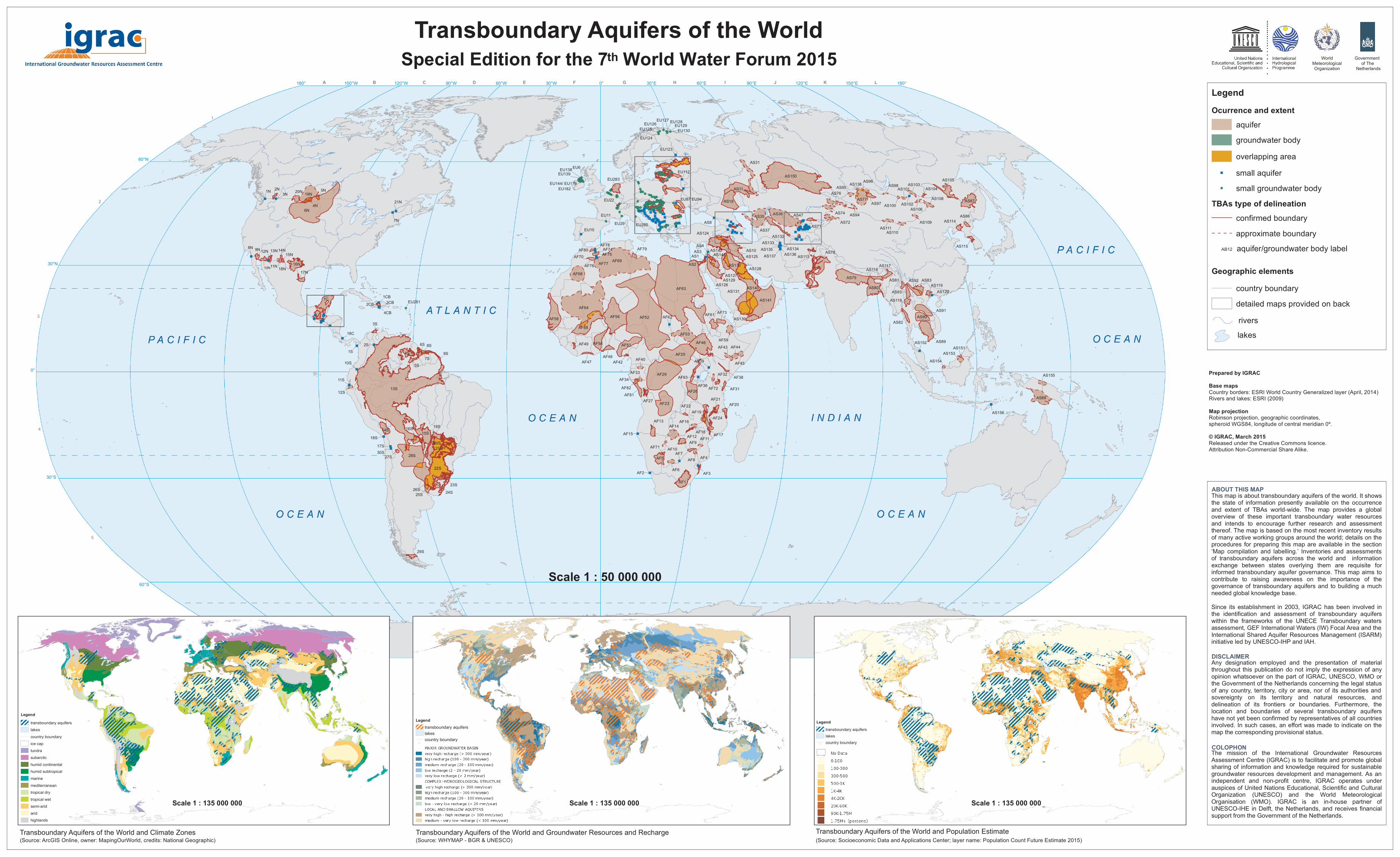
LegendOcurrence and extent

a quife rg round wa te r bod yove rla pping a re a

") s m a ll a quife r!( s m a ll g round wa te r bod y

TBAs type of delineationconfirm e d bound a rya pproxim a te bound a ry

th

Geographic elementscountry bound a ryd e ta ile d m a ps provid e d on ba ck

Legendtra ns bound a ry a quife rsla ke scountry bound a ry

Scale 1 : 135 000 000 Scale 1 : 135 000 000

rive rs

This m a p is a bout tra ns bound a ry a quife rs of the world . It s howsthe s ta te of inform a tion pre s e ntly a va ila ble on the occurre ncea nd e xte nt of TBAs world -wid e . The m a p provid e s a g loba love rvie w of the s e im porta nt tra ns bound a ry wa te r re s ource sa nd inte nd s to e ncoura g e furthe r re s e a rch a nd a s s e s s m e ntthe re of. The m a p is ba s e d on the m os t re ce nt inve ntory re s ultsof m a ny a ctive working g roups a round the world ; d e ta ils on theproce d ure s for pre pa ring this m a p a re a va ila ble in the s e ction‘Ma p com pila tion a nd la be lling .’ Inve ntorie s a nd a s s e s s m e ntsof tra ns bound a ry a quife rs a cros s the world a nd inform a tione xcha ng e be twe e n s ta te s ove rlying the m a re re quis ite forinform e d tra ns bound a ry a quife r g ove rna nce . This m a p a im s tocontribute to ra is ing a wa re ne s s on the im porta nce of theg ove rna nce of tra ns bound a ry a quife rs a nd to build ing a m uchne e d e d g loba l knowle d g e ba s e .Since its e s ta blis hm e nt in 2003, IGRAC ha s be e n involve d inthe id e ntifica tion a nd a s s e s s m e nt of tra ns bound a ry a quife rswithin the fra m e works of the UNECE Tra ns bound a ry wa te rsa s s e s s m e nt, GEF Inte rna tiona l W a te rs (IW ) Foca l Are a a nd theInte rna tiona l Sha re d Aquife r Re s ource s Ma na g e m e nt (ISARM)initia tive le d by UNESCO -IHP a nd IAH.

Any d e s ig na tion e m ploye d a nd the pre s e nta tion of m a te ria lthroug hout this publica tion d o not im ply the e xpre s s ion of a nyopinion wha ts oe ve r on the pa rt of IGRAC, UNESCO , W MO orthe Gove rnm e nt of the Ne the rla nd s conce rning the le g a l s ta tusof a ny country, te rritory, city or a re a , nor of its a uthoritie s a nds ove re ig nty on its te rritory a nd na tura l re s ource s , a ndd e line a tion of its frontie rs or bound a rie s . Furthe rm ore , theloca tion a nd bound a rie s of s e ve ra l tra ns bound a ry a quife rsha ve not ye t be e n confirm e d by re pre s e nta tive s of a ll countrie sinvolve d . In s uch ca s e s , a n e ffort wa s m a d e to ind ica te on them a p the corre s pond ing provis iona l s ta tus .

The m is s ion of the Inte rna tiona l Ground wa te r Re s ource sAs s e s s m e nt Ce ntre (IGRAC) is to fa cilita te a nd prom ote g loba ls ha ring of inform a tion a nd knowle d g e re quire d for s us ta ina bleg round wa te r re s ource s d e ve lopm e nt a nd m a na g e m e nt. As a nind e pe nd e nt a nd non-profit ce ntre , IGRAC ope ra te s und e ra us pice s of Unite d Na tions Ed uca tiona l, Scie ntific a nd Cultura lO rg a niza tion (UNESCO ) a nd the W orld Me te orolog ica lO rg a nis a tion (W MO ). IGRAC is a n in-hous e pa rtne r ofUNESCO -IHE in De lft, the Ne the rla nd s , a nd re ce ive s fina ncia ls upport from the Gove rnm e nt of the Ne the rla nd s .

ABOUT THIS MAP

DISCLAIMER

COLOPHON

W orldMe te orolog ica lO rg a niza tion

Gove rnm e nt of The

Ne the rla nd s

Tra ns bound a ry Aquife rs of the W orld a nd Popula tion Es tim a teTra ns bound a ry Aquife rs of the W orld a nd Clim a te Z one s Tra ns bound a ry Aquife rs of the W orld a nd Ground wa te r Re s ource s a nd Re cha rg e(Source : Socioe conom ic Da ta a nd Applica tions Ce nte r; la ye r na m e : Popula tion Count Future Es tim a te 2015)(Source : W HYMAP - BGR & UNESCO ) (Source : ArcGIS O nline , owne r: Ma ping O urW orld , cre d its : Na tiona l Ge og ra phic)

www.un- .org

- EDITION 2015 - 1 : 50 000 000

THE IMPORTANCE OF GROUNDWATER AND TRANSBOUNDARY

AQUIFERS Groundwater is the most abundant source of freshwater on earth, accounting for approximately 97% of non-frozen fresh water. It is an important natural resource that greatly contributes to human development. Approximately 50% of the world’s population drinks groundwater daily. It is often critical for sustaining rural populations that are located away from surface water and piped infrastructure. With respect to food production, groundwater is estimated to contribute to over 40 percent of the world’s production of irrigated crops. Groundwater sustains ecosystems, maintains base flow of rivers and stabilizes land in areas with easily compressed soils. Aquifers can also buffer impacts resulting from seasonal variability and climate change. However, groundwater does not stop flowing at political borders and huge resources are stored in transboundary aquifers. Therefore, the identification, mapping, assessment and development of governance mechanisms for transboundary aquifers are important tasks for ensuring the sustainability of these resources and peaceful cooperation between countries. There are now 592 identified transboundary aquifers, including transboundary ‘groundwater bodies’ as defined in the European Union Water Framework Directive (EU WFD), underlying almost every nation. The United Nations International Law Commission’s Draft Articles on the Law of Transboundary Aquifers (Draft Articles) define an aquifer as “a permeable water-bearing geological formation underlain by a less permeable layer and the water contained in the saturated zone of the formation.” The Draft Articles further define a transboundary aquifer or a transboundary aquifer system as “an aquifer or aquifer system, parts of which are situated in different States.” The EU WFD defines an aquifer as “a subsurface layer or layers of rock or other geological strata of sufficient porosity and permeability to allow either a significant flow of groundwater or the abstraction of significant quantities of groundwater” and a body of groundwater (a.k.a. groundwater body) as “a distinct volume of groundwater within an aquifer or aquifers.” [Note: Mapping for the European Region includes both transboundary aquifers and transboundary groundwater bodies as explained below in Map Compilation and Labelling]. The number of transboundary aquifers has been increasing steadily since the first ‘Transboundary Aquifers of the World Map; was released in 2009. It is likely that new transboundary aquifers will still be identified in the future and that the delineation of existing transboundary aquifers may be refined once further studies are conducted. For more information on individual transboundary aquifers and groundwater bodies and the extended view of the small aquifers and groundwater bodies, please visit IGRAC’s Global Groundwater Information System (GGIS) online : (https://ggis.un-igrac.org/ggis-viewer/viewer/tbamap/public/default )

CONTACT: Westvest 7, 2611 AX Delft, The Netherlands Phone: +31 15 215 2325 E-mail: [email protected] Website: www.tbamap.un-igrac.org

MAP COMPILATION AND LABELLING

This map encapsulates information provided by various organisations and projects dealing with transboundary aquifer assessments and/or management at regional and continental scales. It is an update of the Transboundary Aquifers of the World Map - Update 2014 (IGRAC 2014). IGRAC compiled this map based on information from peer-reviewed literature and information provided by national experts. Specific information sources are given in the table below. A significant new source of information for the 2015 map was data collected as part of the Global Environment Facility Transboundary Waters Assessment Programme Groundwater Component (TWAP Groundwater). TWAP Groundwater aimed to provide a baseline assessment that identifies and evaluates changes in transboundary water systems caused by human activities and natural processes. TWAP Groundwater’s data collection accessed information about transboundary aquifers greater than 5,000 km3 - a total of 199 transboundary aquifers - that was previously available at national level only. To do so, it mobilized a global network of national groundwater experts. These national experts provided information on the individual countries’ segments, which was merged, resulting in the transboundary aquifers’ delineations. Through a series of regional consultations 74 transboundary aquifers’ delineations were updated, improved, confirmed and/or harmonised. The guiding principle in compiling the 2015 map was to stay as close to the information provided by the individual sources as possible, while presenting the information in a form that is appropriate for the chosen scale of the map (1:50 000 000). For countries in the EU, Switzerland and Norway, the global transboundary aquifer map also displays transboundary groundwater bodies as adopted by the EU WFD. Within this framework, EU Member States are obliged to delineate groundwater bodies with the goal of achieving ‘good quantitative and qualitative status’ by 2015. Groundwater bodies can be either domestic or transboundary. They are not necessarily hydrologic units, but rather management units. In many cases, aquifers are subdivided into groundwater bodies while occasionally groundwater bodies may contain multiple aquifers. Since the content of this map is based on most recent inventories from around the world, transboundary aquifers located within the EU, Switzerland and Norway, which were included in earlier versions of this map, have now been replaced by transboundary groundwater bodies. Non-EU and EU countries continue to share transboundary aquifers, like in earlier versions of the map. In the map key, small transboundary aquifers and groundwater bodies are not larger than 6,000 km2 and are represented by blue squares and green circles, respectively. Solid dark red borders indicate that the aquifers’ delineation is known and confirmed by all sharing countries. There are two situations in which a transboundary aquifer is marked with a dashed line, signifying an approximate or unconfirmed boundary: 1. There is a transboundary aquifer with very limited hydrogeological information, which is

represented by circular or elliptical shape. The size and position of the shape gives a rough indication of size and position of the transboundary aquifer.

2. A transboundary aquifer delineated as part of TWAP Groundwater did not have all countries’ individual map segments confirmed and/or harmonized by national experts. For some aquifers, one or more of the country’s segments is considered definite, but this distinction is not on this map.

For transboundary aquifers that were not assessed as part of TWAP Groundwater and where different sources provided incongruent delineations, delineations with the highest level of certainty were chosen. The map also contains a number of transboundary aquifers that may not formally be recognised by all countries. Various transboundary aquifers and groundwater bodies are identified as overlapping or overlaying. For larger transboundary aquifers and transboundary groundwater bodies, orange polygons represent overlapping areas. For smaller overlapping transboundary aquifers and groundwater bodies, this differentiation has not been made. Each transboundary aquifer and transboundary groundwater body is uniquely labeled with a code. At present, there is no internationally adopted or consistent system of labelling transboundary aquifers. To ensure legibility in areas with a high density of transboundary aquifers, in particular Europe, only large transboundary aquifers and groundwater bodies are labeled. For aquifers in the Americas, coding is the same as used by the Organization of American States (OAS). For the other regions, the code comprises two letters selected by IGRAC to identify the continent or region and a number to identify the individual aquifer. For reference purposes, coding of transboundary aquifers and transboundary groundwater bodies included in previous versions of the Transboundary Aquifers of the World Map were maintained as much as possible, but some exceptions were made. There are instances where an existing transboundary aquifer have been split into two or more new transboundary aquifers, and there are cases where multiple transboundary aquifers have been merged. In those instances the old aquifer code was deleted from the list and the newly delineated transboundary aquifers were added to the bottom of the list, resulting in ‘missing aquifer codes.’ Newly identified aquifers have also been added to the list sequentially by region. The table of labels also contains a grid code column indicating the grid cell(s) of the main map in which each transboundary aquifer and transboundary groundwater body is located. Mapping of transboundary aquifers and transboundary groundwater bodies is a specific step towards transboundary governance of environmental resources that occurs within a broader, sometimes political, process between countries. However, knowledge about transboundary aquifers is still limited. Therefore, individuals and organisations (national and international, governmental and non-governmental) are invited to provide comments and suggestions to further improve the Transboundary Aquifers of the World map.

ABOUT THE THEMATIC MAPS

The 2015 special edition of the Transboundary Aquifers of the World Map includes three thematic maps. These maps combine the delineations of the transboundary aquifers of the world with maps of climate zones, groundwater resources and recharge, and population. Viewed side by side, these three maps give an indication of the potential for groundwater to contribute to sustainable development by showing the relation of climate, potential for groundwater recharge, and the potential for populations to use or rely upon these resources. Details about each of the three thematic maps are provided below. Climate Zones The Köppen Climate Zones are the most commonly used climate classification systems and are based on the assumption that vegetation is the best indicator of climate. The system includes five main climate groups each with several subgroups. This thematic map uses a simplified version of these subgroups, compiled by National Geographic, to increase the clarity of the map. By overlaying the transboundary aquifers of the world with the map of simplified climate zones, there is a broad indication of the range of climatic conditions that influence transboundary aquifers.

Groundwater Resources and Recharge The WHYMAP program gathered and summarized select information from global data sets to show the characteristics groundwater environments. The map uses the blue colour for large and rather uniform aquifers and aquifer systems that may offer good conditions for groundwater exploitation, the green colour for areas with highly productive aquifers in complex hydrogeological structures, and the brown colour for regions with local and shallow aquifers that may contain productive aquifers. Within the three main hydrogeological units, up to five different categories, derived from modeling simulations, are defined according to their potential recharge rates. Overlaying the transboundary aquifers of the world onto the WHYMAP allows a general classification of the potential for development of the aquifers for human use as well as a simplified understanding of the geological environment in which the aquifers reside. Population In the third thematic map, the transboundary aquifers of the world overlay the projected 2015 world population. The future estimate population values are extrapolated based on a combination of subnational growth rates from census dates and national growth rates. All of the grids have been adjusted to match United Nations national level population estimates. This thematic map provides a rough indication of how many people may be accessing or depending on groundwater from transboundary aquifers now or in the future.

ACKNOWLEDGEMENTS

We would like to thank the many organizations and experts that provided the data made available on this map. In particular, we would like to thank the professionals involved in TWAP, a programme that has helped to provide new delineations of previously unidentified aquifers and improve the accuracy of delineations of known aquifers for this edition. Furthermore, we would like to express our gratitude to the three organisations supporting IGRAC: UNESCO, WMO and the Government of The Netherlands.

REFERENCES

Altchenko, Y and Villholth, K.G. (2013). Transboundary aquifer mapping and management in Africa:

a harmonised approach, Hydrogeology Journal, DOI 10.1007/s10040-013-1002-3. Braune E. and Y. Xu (2011). Transboundary Aquifer Utilization and Management in Southern

Africa, ISARM-SADC since 2005, A Position Paper for the UNESCO Cluster Office, Harare, UNESCO Chair in Groundwater, University of the Western Cape, Bellville, Cape Town, South Africa.

Brooks, D.B., and Linton J. (2011). Governance of Transboundary Aquifers: Balancing Efficiency, Equity and Sustainability. International Journal of Water Resources Development, 27(3), 436.

DIKTAS (2013). DIKTAS Transboundary Diagnostic Analysis, Annex 1: DIKTAS Maps, Available from: http://diktas.iwlearn.org/resources/projectdocuments/transboundart-diagniostics-analysis/tda-annex-1-maps/view [Accessed 01 May 2014].

Eckstein, G., & Sindico, F. (2014). The Law of Transboundary Aquifers: Many Ways of Going Forward, but Only One Way of Standing Still. Review of European, Comparative & International Environmental Law, 23(1), 32-42.

EEA (2012). WISE provisional reference GIS Water Framework Directive (WFD) dataset on Groundwater Bodies. - PUBLIC VERSION, Oct. 2012.

Falkenmark, M. (1990). Global Water Issues Confronting Humanity, Journal of Peace Res., 27(2). Foster, S., Chilton, J., Nijsten, G.-J., & Richts, A. (2013). Groundwater—a global focus on the ‘local

resource’. Current Opinion in Environmental Sustainability, 5(6), 685-695. IAEA/UNDP/GEF (2007). Nubian Sandstone Aquifer System (NSAS) Technical Baseline Meeting,

IAEA RAF/8/036, p.10 (43 pages) – Vienna. IEMED/ CIDOB (2008). Groundwater Resources in the Mediterranean Region: Importance, Uses

and Sharing, In Mediterranean Yearbook Med, p. 96–106. IGRAC (2009). Transboundary Aquifers of the World, Update 2009, Scale 1:50 000 000, Special

edition for the 5th World Water Forum, Istanbul. INWEB (2011). Inventory of Internationally shared Aquifers, International Network of Water- Environment Centers for the Balkans, Available from: http://www.inweb.gr/index.php?

option=com_aquifers_db [Accessed 30 Dec 2011]. ISARM- Africa/UNESCO (2004). Managing Shared Aquifer Resources in Africa, IHP-VI, Series on

Groundwater No. 8, ISARM – Africa. ISARM-SADC (2007). Terms of reference for Establishment of a TBA NETWORK in SADC, ISARM-

SADC meeting, Pretoria. Kukuric N., Gun van der J. and S. Vasak (2008). Towards a Methodology for the Assessment of

Internationally Shared Groundwaters, 4th International Symposium on Transboundary Waters Management - Thessaloniki, 2008.

Marchard de Gramont, H., et al., (2011) ‘Towards a Joint Management of Transboundary Aquifer Systems’, A Savoir Publication No. 3(9).

Margat, J., & van der Gun, J. (2013). Groundwater Around the World. Lieden, Netherlands: CRC Press/Balkema.

OSS/UNEP/GEF (2008a). Iullemeden Boundary limits, Managing hydrological risk in the Iullemeden Aquifer system, http://iullemeden.iwlearn.org/gis/boundary.jpg/view [Accessed 30 Dec 2011]

OSS/UNEP/GEF (2008b). The Aquifer System (Main Basins Aquifers) - Connaissance du Système Aquifère, North-Western Sahara Aquifer project documents, p. 2.

Puri, S. and A. Aureli (2005). Transboundary aquifers: A Global Program to Assess, Evaluate and Develop Policy, Groundwater, Vol. 43 (5), pp 661-668.

SADC (2011). Explanatory Brochure for the Southern African Development Community (SADC) Hydrogeological Map & Atlas, Technical Assistance to the Southern Africa Development Community (SADC) - “SADC Hydrogeological Mapping Project”, A report to the Southern African Development Community (SADC) and Cooperating Partners: European Union and GTZ.

Shiklomanov, I. (1993). Water in crisis: a guide to the world's fresh water resources. In P. H. Gleick, & others (Eds.). Oxford University Press, Inc.

Siebert, S., Burke, J., Faures, J.-M., Frenken, K., Hoogeveen, J., Döll, P., & Portmann, F. T. (2010). Groundwater use for irrigation--a global inventory. Hydrology and Earth System Sciences Discussions, 7(3), 3977-4021.

UNECE (1999). Inventory of Transboundary Groundwater, UN/ECE Task Force on Monitoring and Assessment Volume 1, Lelystad.

UNECE (2007). Our Waters: Joining Hands Across Borders, First Assessment of Transboundary Rivers, Lakes and Groundwaters, Part 3 Section II, New York/ Geneva.

UNECE (2011). Second Assessment of Transboundary Rivers, Lakes and Groundwaters, Economic Commission for Europe, Convention on the Protection and Use of Transboundary Watercourses

and International Lakes, ISBN 978-92-1-117052-8. UNESCO (2006). Transboundary Aquifers in Asia With Special Emphasis to China (44 pages) . UNESCO (2007). Sistemas Acuíferos Transfronterizos en la Américas – Evaluación Preliminar, Serie ISARM Américas N°1, Montevideo/ Washington DC.

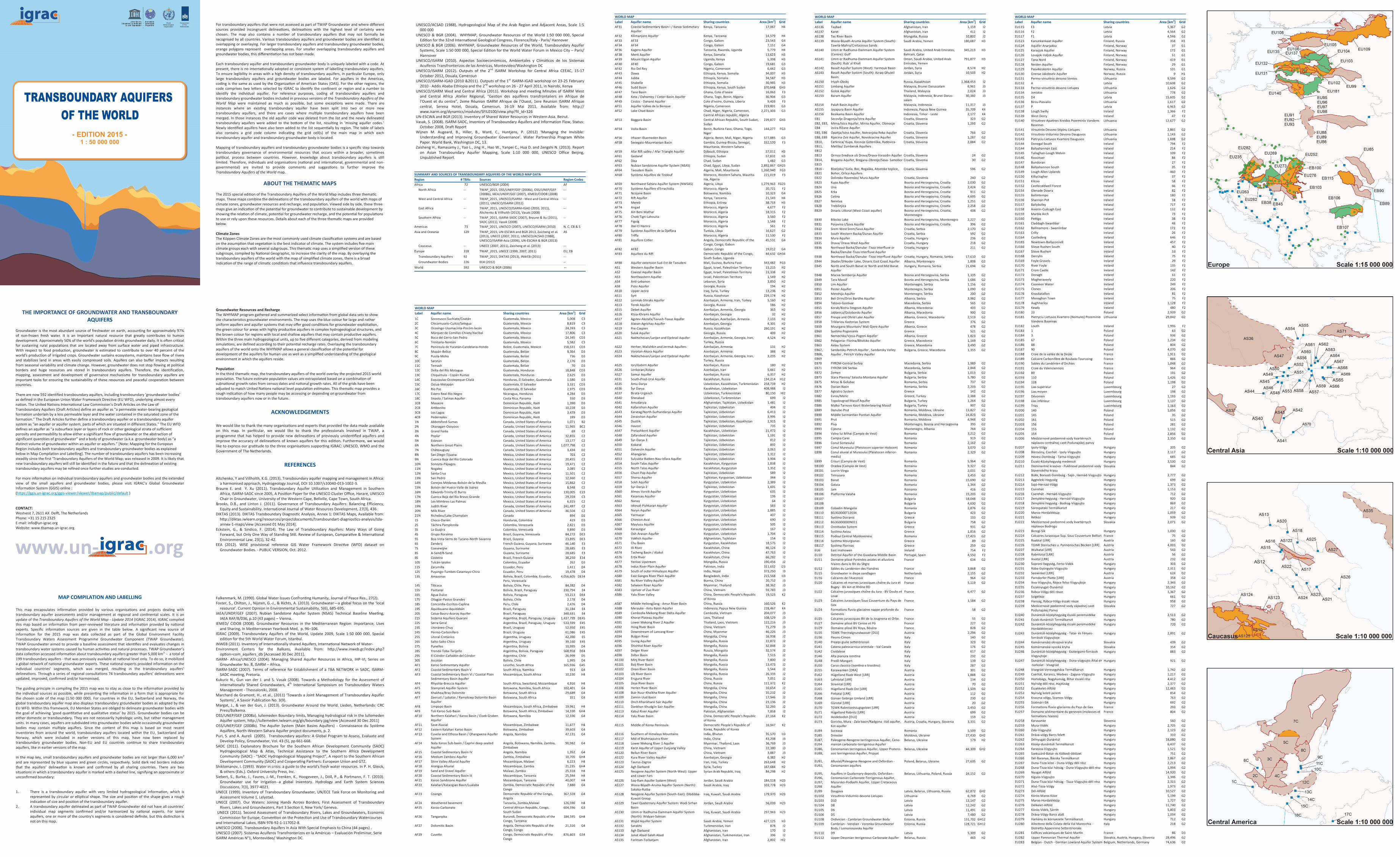
SUMMARY AND SOURCES OF TRANSBOUNDARY AQUIFERS OF THE WORLD MAP DATA

Region # TBAs Sources Region Codes

Africa 72 UNESCO/BGR (2004) AF

North Africa -- TWAP_2015, OSS/UNEP/GEF (2008a), OSS/UNEP/GEF (2008b), IAEA/UNDP/GEF (2007), IEMED/CIDOB (2008)

--

West and Central Africa -- TWAP_2015, UNESCO/ISARM - West and Central Africa (2011), UNESCO/ISARM (2012)

--

East Africa -- TWAP_2015, UNESCO/ISARM-IGAD (2010, 2011), Altchenko & Villholth (2013), Vasak (2008)

--

Southern Africa -- TWAP_2015, ISARM-SADC (2007), Braune & Xu (2011), SADC (2011), Vasak (2008)

--

Americas 73 TWAP_2015, UNESCO (2007), UNESCO/ISARM (2010) N, C, CB & S

Asia and Oceania 129 TWAP_2015, UN-ESCWA and BGR 2013, Zaicheng et al. (2013), UNECE (2007, 2011), UNESCO/ACSAD (1988), UNESCO/ISARM-Asia (2006), UN-ESCWA & BGR (2013)

AS

Caucasus -- UNECE (2007, 2011), Zaisheng et al. (2013) --

Europe 318 TWAP_2015, UNECE (1999, 2007, 2011) EU, EB

Transboundary Aquifers 92 TWAP_2015, DIKTAS (2013), INWEB (2011) --

Groundwater Bodies 226 EEA (2012) --

World 592 UNESCO & BGR (2006) --

WORLD MAP

Label Aquifer name Sharing countries Area [km2] Grid

WORLD MAP

Label Aquifer name Sharing countries Area [km2] Grid

WORLD MAP

Label Aquifer name Sharing countries Area [km2] Grid

WORLD MAP

Label Aquifer name Sharing countries Area [km2] Grid

EU164 Castlederg Ireland 646 F2

EU165 Newtown-Ballyconnell Ireland 457 F2

EU166 Slieve Rushen South Ireland 40 F2

EU167 Slieve Rushen Ireland 53 F2

EU168 Derrylin Ireland 75 F2

EU169 Foyle Gravels Ireland 29 F2

EU170 River Foyle Ireland 135 F2

EU171 Crom Castle Ireland 142 F2

EU172 Donagh Ireland 61 F2

EU173 Magheraveely Ireland 220 F2

EU174 Cooneen Water Ireland 249 F2

EU175 Clones Ireland 206 F2

EU176 Knockatallon Ireland 81 F2

EU177 Monaghan Town Ireland 75 F2

EU178 Aughnacloy Ireland 1,128 F2

EU179 Keady Ireland 480 F2

EU180 23 Poland 2,939 G2

EU181 Pietryciu Lietuvos Kvartero (Nemuno) Pozeminio Vandens Baseinas

Lithuania 29,842 G2

EU182 Louth Ireland 1,995 F2

EU183 1 Poland 63 G2

EU184 3 Poland 936 G2

EU185 67 Poland 1,234 G2

EU186 88 Poland 804 G2

EU187 90 Poland 4,070 G2

EU188 Craie de la vallée de la Deûle France 1,911 G2

EU189 Calcaire Carbonifère de Roubaix-Tourcoing France 866 G2

EU190 Sables du Landénien d'Orchies France 1,048 G2

EU191 Craie du Valenciennois France 964 G2

EU192 89 Poland 191 G2

EU193 110 Poland 1,426 G2

EU194 128 Poland 1,198 G2

EU195 Lias supérieur Luxembourg 27 G2

EU196 Lias moyen Luxembourg 198 G2

EU197 Dévonien Luxembourg 1,193 G2

EU198 Lias inférieur Luxembourg 1,137 G2

EU199 Trias Luxembourg 1,163 G2

EU200 140 Poland 1,056 G2

EU201 145 Poland 35 G2

EU202 161 Poland 515 G2

EU203 156 Poland 281 G2

EU204 155 Poland 1,132 G2

EU205 154 Poland 2,856 G2

EU206 Medzizrnové podzemné vody kvartérnych náplavov centrálnej casti Podunajskej panvy

Slovakia 2,350 G2

EU207 Ipoly-Völgy Hungary 205 G2

EU208 Börzsöny, Cserhát - Ipoly-Vízgyujto Hungary 2,117 G2

EU209 Hevesi-Dombság - Tarna-Vízgyujto Hungary 685 G2

EU210 Északi-Középhegység medencéi Hungary 3,530 G2

EU211 Dominantné krasovo - Puklinové podzemné vody Slovenského krasu

Slovakia 844 G2

EU212 Bükk, Borsodi-Dombság - Sajó-, Hernád-Vízgyujto Hungary 2,777 G2

EU213 Aggteleki-Hegység Hungary 699 G2

EU214 Sajó-Hernád-Völgy Hungary 1,373 G2

EU215 Cserehát Hungary 1,153 G2

EU216 Cserehát - Hernád-Vízgyujto Hungary 712 G2

EU217 Zempléni-hegység - Hernád-Vízgyujto Hungary 920 G2

EU218 Zempléni-hegység - Bodrog-Vízgyujto Hungary 869 G2

EU219 Sárospataki Termálkarszt Hungary 217 G2

EU220 Maros-Hordalékkúp Hungary 1,059 G2

EU221 Rétköz Hungary 939 G2

EU222 Medzizrnové podzemné vody kvartérnych náplavov Bodrogu

Slovakia 2,071 G2

EU223 Beregi-Sík Hungary 1,030 G2

EU224 Calcaires Jurassique Sup. Sous Couverture Belfort France 75 G2

EU225 Raabtal [LRR] Austria 160 G2

EU226 TGWK Steirisches u. Pannonisches Becken [LRR] Austria 4,003 G2

EU227 Wulkatal [LRR] Austria 543 G2

EU228 Rabnitztal [LRR] Austria 56 G2

EU229 Ikvatal [LRR] Austria 232 G2

EU230 Soproni-hegység, Ferto-Vidék Hungary 303 G2

EU231 Rába-Gyöngyös-Vízgyujto Hungary 2,311 G2

EU232 Seewinkel [LRR] Austria 624 G2

EU233 Parndorfer Platte [LRR] Austria 358 G2

EU234 Ikva-Vízgyujto, Répce felso Vízgyujtoje Hungary 2,343 G2

EU235 Északnyugat-Dunántúl Hungary 10,162 G2

EU236 Rábca-Völgy déli része Hungary 1,367 G2

EU237 Szigetköz Hungary 661 G2

EU238 Hanság, Rábca-Völgy északi része Hungary 958 G2

EU239 Medzizrnové podzemné vody západnej casti Podunajskej Panvy

Slovakia 727 G2

EU240 Dunántúli-középhegység északi peremvidéke Hungary 2,513 G2

EU241 Észak-dunántúli Termálkarszt Hungary 780 G2

EU242 Dunántúli-középhegység északi peremvidéke Hordalékterasz

Hungary 720 G2

EU243 Dunántúli-középhegység - Tatai- és Fényes-források Vízgyujtoje

Hungary 2,891 G2

EU244 Komárnanská okrajová kryha Slovakia 439 G2

EU245 Komárnanská vysoká kryha Slovakia 354 G2

EU246 Dunántúli-középhegység - Esztergomi-források Vízgyujtoje

Hungary 883 G2

EU247 Dunántúli-középhegység - Duna-vízgyujto Által-ér-torkolat - Visegrád

Hungary 921 G2

EU248 Visegrád-Veresegyháza Termálkarszt Hungary 1,742 G2

EU249 Cserhát, Karancs, Medves - Zagyva-Vízgyujto Hungary 1,217 G2

EU250 Hortobágy, Nagykunság, Bihar északi rész Hungary 4,412 G2

EU251 Nyírség déli rész, Hajdúság Hungary 2,377 G2

EU252 Északkelet-Alföld Hungary 12,463 G2

EU253 Nyírség keleti perem Hungary 854 G2

EU254 Kraszna-völgy, Szamos-Völgy Hungary 763 G2

EU255 Szatmári-Sík Hungary 692 G2

EU256 Formations fluvio-glaciaires du Pays de Gex France 293 G2

EU257 Domaine sédimentaire du genevois (molasses et formations IVaires)

France 804 G2

EU258 Karavanke Slovenia 560 G2

EU259 Mura-Vidék Hungary 2,705 G2

EU260 Zala-Vízgyujto Hungary 2,123 G2

EU261 Dráva-völgy Barcs felett Hungary 310 G2

EU262 Délnyugat-Dunántúl Hungary 18,880 G2

EU263 Közép-dunántúli Termálkarszt Hungary 6,437 G2

EU264 Karasica-Vízgyujto Hungary 1,521 G2

EU265 Szekszárd-Bátai- és Kölkedi-öblözet Hungary 751 G2

EU266 Dél-Baranya, Bácska Termálkarszt Hungary 2,867 G2

EU267 Duna-Tisza köze - Duna-Völgy déli rész Hungary 2,213 G2

EU268 Duna-Tisza közi hátság - Duna-Vízgyujto déli rész Hungary 1,994 G2

EU269 Nyugat-Alföld Hungary 14,920 G2

EU270 Kígyós-Vízgyujto Hungary 1,346 G2

EU271 Duna-Tisza közi hátság - Tisza-Vízgyujto déli rész Hungary 2,315 G2

EU272 Alsó-Tisza-Völgy Hungary 1,973 G2

EU273 Dél-Alföld Hungary 10,527 G2

EU274 Körös-Maros Köze Hungary 5,199 G2

EU275 Maros-Hordalékkúp Hungary 1,727 G2

EU276 Délkelet-Alföld Hungary 11,740 G2

EU277 Körös-Vidék, Sárrét Hungary 5,803 G2

EU278 Dráva-Völgy Barcs alatt Hungary 1,034 G2

EU279 Harkány és környezete Termálkarszt Hungary 712 G2

EU280 Alloctono della Colata della Val Marecchia - Distretto Appennino Settentrionale

Italy 218 G2

EU281 Edifices volcaniques de Saint-Martin France 86 D3

EU282 Upper Pannonian Thermal Aquifer Slovakia, Austria, Hungary, Slovenia 28,496 G2

EU283 Belgian - Dutch - German Lowland Aquifer System Belgium, Netherlands, Germany 74,636 G2

EU115 F3 Latvia 5,367 G2

EU116 F2 Latvia 4,564 G2

EU117 F1 Latvia 4,546 G2

EU123 Kanunkankaat Aquifer Finland, Russia 358 H1

EU124 Aquifer Anarjokka Finland, Norway 37 G1

EU125 Karasjok Aquifer Finland, Norway 172 G1

EU126 Levajok-Valjok Aquifer Finland, Norway 51 G1

EU127 Tana Nord Finland, Norway 419 G1

EU128 Neiden Aquifer Finland, Norway 29 G1

EU129 Pasvikeskeren Aquifer Norway, Russia 101 G1

EU130 Grense Jakobselv Aquifer Norway, Russia 9 H1

EU131 Permo-virsutinio devono Ventos Lithuania 9,599 G2

EU132 A Latvia 10,608 G2

EU133 Permo-virsutinio devono Lielupes Lithuania 1,626 G2

EU134 Joniskio Lithuania 778 G2

EU135 D4 Latvia 15,605 G2

EU136 Birzu-Pasvalio Lithuania 1,617 G2

EU137 P Latvia 6,963 G2

EU138 Lough Swilly Ireland 1,366 F2

EU139 West Derry Ireland 47 F2

EU140 Virsutines-Apatines Kreidos Pozeminio Vandens Baseinas

Lithuania 12,677 G2

EU141 Virsutinio Devono Stipinu Lielupes Lithuania 2,865 G2

EU142 Virsutinio-Vidurinio Devono Dauguvos Lithuania 1,143 G2

EU143 Pietryciu Lietuvos Kvartero Dauguvos Lithuania 1,698 G2

EU144 Donegal South Ireland 794 F2

EU144 Ballyshannon East Ireland 214 F2

EU145 Tullaghan-Lough Melvin Ireland 109 F2

EU146 Rossinver Ireland 84 F2

EU147 Bundoran Ireland 27 F2

EU148 Ballyshannon South Ireland 35 F2

EU149 Lough Allen Uplands Ireland 460 F2

EU150 Kiltyclogher Ireland 37 F2

EU151 Kilcoo Ireland 58 F2

EU152 Castlecaldwell Forest Ireland 66 F2

EU154 Glenade Dowra Ireland 82 F2

EU155 Ballintempo Ireland 180 F2

EU156 Shannon Pot Ireland 18 F2

EU157 Ballybofey Ireland 717 F2

EU158 Anierin-Cuilcagh East Ireland 132 F2

EU159 Marble Arch Ireland 73 F2

EU160 Pettigo Ireland 38 F2

EU161 Claddagh-Swanlibar Ireland 48 F2

EU162 Ballinamore - Swanlinbar Ireland 172 F2

EU163 Crilly Ireland 26 F2

AS136 Taybad Afghanistan, Iran 1,159 I2

AS137 Karet Afghanistan, Iran 411 I2

AS138 Tes River Basin Mongolia, Russia 10,802 J2

AS139 Wasia-Biyadh-Aruma Aquifer System (South): Tawila-Mahra/Cretaceous Sands

Saudi Arabia, Yemen 180,087 H3

AS140 Umm er Radhuma-Dammam Aquifer System (Centre): Gulf

Saudi Arabia, United Arab Emirates, Bahrain, Qatar

345,213 H3

AS141 Umm er Radhuma-Dammam Aquifer System (South): Rub' al Khali

Oman, Saudi Arabia, United Arab Emirates, Yemen

791,877 H3

AS142 Basalt Aquifer System (West): Yarmouk Basin Jordan, Syria 8,574 H2

AS143 Basalt Aquifer System (South): Azraq-Dhuleil Basin

Jordan, Syria 10,503 H2

AS150 Irtysh-Obsky Russia, Kazakhstan 1,368,453 I2

AS151 Limbang Aquifer Malaysia, Brunei Darussalam 6,961 J3

AS152 Golok Aquifer Thailand, Malaysia 2,024 J3

AS153 Baram Aquifer Malaysia, Indonesia, Brunei Darus-salam

30,382 J3

AS154 Palah Basin Aquifer Malaysia, Indonesia 11,317 J3

AS155 Jayapura Basin Aquifer Indonesia, Papua New Guinea 35,709 K4

AS156 Besikama Basin Aquifer Indonesia, Timor - Leste 2,177 K4

EB1 Secovlje-Dragonja/Istra Aquifer Croatia, Slovenia 323 G2

EB2, EB3, EB4

Mirna/Istra Aquifer, Mirna Aquifer, Obmocje izvira Rižane Aquifer

Croatia, Slovenia 1,293 G2

EB5, EB6 Opatija/Istra Aquifer, Notranjska Reka Aquifer Croatia, Slovenia 766 G2

EB8, EB9 Rijecina-Zvir Aquifer, Novokracine Aquifer Croatia, Slovenia 1,287 G2

EB10, EB11, EB12

Cerknica/ Kupa, Kocevje Goteniška, Radovica-Metlika/ Zumberak Aquifers

Croatia, Slovenia 2,884 G2

EB13 Ormoz-Sredisce ob Drava/Drava-Varazdin Aquifer Croatia, Slovenia 24 G2

EB14, EB15

Bregana Aquifer, Bregana-Obrezje/Sava- Samobor Croatia, Slovenia 30 G2

EB16 - EB21

Bizeljsko/ Sutla, Boc, Rogaška, Atomske toplice, Bohor, Orlica Aquifers

Croatia, Slovenia 596 G2

AF31 Coastal Sedimentary Basin I / Karoo Sedimetary Aquifer

Kenya, Tanzania 17,067 H4

AF32 Kilimanjaro Aquifer Kenya, Tanzania 14,579 H4

AF33 AF33 Congo, Gabon 23,543 G4

AF34 AF34 Congo, Gabon 7,151 G4

AF36 Kagera Aquifer Tanzania, Rwanda, Uganda 5,779 H4

AF38 Merti Aquifer Kenya, Somalia 13,623 H3

AF39 Mount Elgon Aquifer Uganda, Kenya 5,398 H3

AF40 AF40 Congo, Gabon 19,681 G3

AF42 Rio Del Rey Nigeria, Cameroon 6,442 G3

AF43 Dawa Ethiopia, Kenya, Somalia 34,007 H3

AF44 Jubba Ethiopia, Somalia 34,587 H3

AF45 Shabelle Ethiopia, Somalia 30,985 H3

AF46 Sudd Basin Ethiopia, Kenya, South Sudan 370,648 GH3

AF47 Tano Basin Ghana, Cote d'Ivoire 16,063 F3

AF48 Keta / Dahomey / Cotier Basin Aquifer Ghana, Togo, Benin, Nigeria 36,904 G3

AF49 Cestos - Danané Aquifer Cote d'Ivoire, Guinea, Liberia 9,403 F3

AF51 Aquifer Vallee de la Benoue Nigeria, Cameroon 219,001 G3

AF52 Lake Chad Basin Chad, Niger, Nigeria, Cameroon, Central African republic, Algeria

2,271,303 G3

AF53 Baggara Basin Central African Republic, South Sudan, Sudan

239,877 GH3

AF54 Volta Basin Benin, Burkina Faso, Ghana, Togo, Niger

144,277 FG3

AF56 Irhazer-Illuemeden Basin Algeria, Benin, Mali, Niger, Nigeria 577,885 G3

AF58 Senegalo-Mauretanian Basin Gambia, Guinea-Bissau, Senegal, Mauritania, Western Sahara

332,570 F3

AF59 Afar Rift valley / Afar Triangle Aquifer Djibouti, Ethiopia 57,011 H3

AF61 Gedaref Ethiopia, Sudan 57,831 H3

AF62 Disa Chad, Sudan 1,482 G3

AF63 Nubian Sandstone Aquifer System (NSAS) Chad, Egypt, Libya, Sudan 2,892,867 GH23

AF64 Taoudeni Basin Algeria, Mali, Mauritania 1,260,940 FG3

AF68 Système Aquifère de Tindouf Morocco, Western Sahara, Maurita-nia, Algeria

221,019 F3

AF69 Northwest Sahara Aquifer System (NWSAS) Algeria, Libya 1,279,963 FG23

AF70 Système Aquifère d'Errachidia Morocco, Algeria 20,721 F2

AF71 Ncojane Basin Botswana, Namibia 10,323 G4

AF72 Rift Aquifer Kenya, Tanzania 21,145 H4

AF73 Mereb Ethiopia, Eritrea 38,753 H3

AF74 Angad Morocco, Algeria 4,677 F2

AF75 Ain Beni Mathar Morocco, Algeria 18,315 F2

AF76 Chott Tigri-Lahouita Morocco, Algeria 3,560 F2

AF77 Figuig Morocco, Algeria 1,546 F2

AF78 Jbel El Hamra Morocco, Algeria 561 F2

AF79 Système Aquifère de la Djeffara Tunisia, Libya 16,627 G2

AF80 Triffa Morocco, Algeria 11,530 F2

AF81 Aquifere Cotier Angola, Democratic Republic of the Congo, Congo, Gabon

45,531 G4

AF82 AF82 Gabon, Congo 19,012 G4

AF83 Aquifere du Rift Democratic Republic of the Congo, South Sudan, Uganda

44,632 GH34

AF88 Aquifer extension Sud-Est de Taoudeni Mali, Guinea, Burkina Faso 343,482 FG3

1C Soconusco-Suchiate/Coatán Guatemala, Mexico 5,008 C3

2C Chicomuselo-Cuilco/Selegua Guatemala, Mexico 8,819 C3

3C Ocosingo-Usumacinta-Pocóm-Ixcán Guatemala, Mexico 24,393 C3

4C Márquez de Comillas-Chixoy/Xaclbal Guatemala, Mexico 17,806 C3

5C Boca del Cerro-San Pedro Guatemala, Mexico 24,345 CD3

6C Trinitaria-Nentón Guatemala, Mexico 5,582 C3

7C Península de Yucatán-Candelaria-Hondo Belize, Guatemala, Mexico 158,531 CD3

8C Mopán-Belice Guatemala, Belize 9,364 D3

9C Pusila-Moho Guatemala, Belize 736 D3

10C Sarstún Guatemala, Belize 2,176 D3

11C Temash Guatemala, Belize 70 D3

12C Delta del Río Motagua Guatemala, Honduras 18,848 CD3

13C Chiquimula - Copán Ruinas Guatemala, Honduras 2,625 D3

14C Esquipulas-Ocotepeque-Citalá Honduras, El Salvador, Guatemala 1,580 D3

15C Ostua-Metapán Guatemala, El Salvador 3,331 CD3

16C Río Paz Guatemala, El Salvador 2,975 CD3

17C Estero Real-Río Negro Nicaragua, Honduras 4,284 D3

18C Sixaola / Salinas Aquifer Costa Rica, Panama 550 D3

1CB Masacre Dominican Republic, Haiti 1,390 D3

2CB Artibonito Dominican Republic, Haiti 10,228 D3

3CB Los Lagos Dominican Republic, Haiti 3,479 D3

4CB Pedernales Dominican Republic, Haiti 199 D3

1N Abbotsford-Sumas Canada, United States of America 1,071 B2

2N Okanagan-Osoyoos Canada, United States of America 11,965 BC2

3N Grand Forks Canada, United States of America 69 C2

4N Poplar Canada, United States of America 32,855 C2

5N Estevan Canada, United States of America 13,177 C2

6N Northern Great Plains Canada, United States of America 1,077,798 C2

7N Châteauguay Canada, United States of America 3,434 D2

8N San Diego-Tijuana Mexico, United States of America 703 C2

9N Cuenca Baja del Río Colorado Mexico, United States of America 20,455 C2

10N Sonoyta-Pápagos Mexico, United States of America 19,471 C2

11N Nogales Mexico, United States of America 2,085 C2

12N Santa Cruz Mexico, United States of America 11,501 C2

13N San Pedro Mexico, United States of America 12,660 C2

14N Conejos Médanos-Bolsón de la Mesilla Mexico, United States of America 15,862 C2

15N Bolsón del Hueco-Valle de Juárez Mexico, United States of America 8,548 C2

16N Edwards-Trinity-El Burro Mexico, United States of America 130,005 C23

17N Cuenca Baja del Río Bravo-Grande Mexico, United States of America 29,359 C3

18N Los Mimbres-Las Palmas Mexico, United States of America 6,315 C2

19N Judith River Canada, United States of America 241,497 C2

20N Milk River Canada, United States of America 36,504 C2

21N Richelieu/Lake Champlain Canada 894 D2

1S Choco-Darién Honduras, Colombia 419 D3

2S Táchira Pamplonita Colombia, Venezuela 2,821 D3

3S La Guajira Colombia, Venezuela 9,890 D3

4S Grupo Roraima Brazil, Guyana, Venezuela 84,272 DE3

5S Boa Vista-Serra do Tucano-North Savanna Brazil, Guyana 23,895 DE3

6S Zanderij French Guiana, Guyana, Suriname 46,140 E3

7S Coesewijne Guyana, Suriname 28,685 E3

8S A-Sand/B-Sand Guyana, Suriname 28,685 E3

9S Costeiro Brazil, French Guiana 38,250 E34

10S Tulcán-Ipiales Colombia, Ecuador 262 D3

11S Zarumilla Ecuador, Peru 1,411 D4

12S Puyango-Tumbes-Catamayo-Chira Ecuador, Peru 19,478 D4

13S Amazonas Bolivia, Brazil, Colombia, Ecuador, Peru, Venezuela

4,056,605 DE34

14S Titicaca Bolivia, Chile, Peru 84,382 D4

15S Pantanal Bolivia, Brazil, Paraguay 230,794 E4

16S Agua Dulce Bolivia, Paraguay 53,213 DE4

17S Ollagüe-Pastos Grandes Bolivia, Chile 2,178 D4

18S Concordia-Escritos-Caplina Peru, Chile 2,476 D4

19S Aquidauana-Aquidabán Brazil, Paraguay 31,184 E4

20S Caiua-Bauru-Acaray Aquifer Brazil, Paraguay 348,631 E4

21S Sistema Aquífero Guaraní Argentina, Brazil, Paraguay, Uruguay 1,437,799 DE45

22S Serra Geral Argentina, Brazil, Paraguay, Uruguay 533,599 E45

23S Litoráneo-Chuy Brazil, Uruguay 52,950 E45

24S Permo-Carbonífero Brazil, Uruguay 61,086 E45

25S Litoral-Cretácico Argentina, Uruguay 42,390 E5

26S Salto-Salto Chico Argentina, Uruguay 39,160 E45

27S Puneños Argentina, Bolivia 10,995 D4

28S Yrendá-Toba-Tarijeño Argentina, Bolivia, Paraguay 568,958 DE4

29S El Cóndor-Cañadón del Cóndor Argentina, Chile 26,999 D5

30S Ascotán Bolivia, Chile 1,995 D4

AF1 Karoo Sedimentary Aquifer Lesotho, South Africa 165,936 G45

AF2 Coastal Sedimentary Basin V South Africa, Namibia 913 G4

AF3 Coastal Sedimentary Basin VI / Coastal Plain Sedimentary Basin Aquifer

Mozambique, South Africa 10,230 H4

AF4 Rhyolite-Breccia Aquifer South Africa, Swaziland, Mozambique 4,916 H4

AF5 Stampriet Aquifer System Botswana, Namibia, South Africa 102,401 G4

AF6 Khakhea/Bray Dolomite Botswana, South Africa 29,689 G4

AF7 Zeerust / Lobatse / Ramotswa Dolomite Basin Aquifer

Botswana, South Africa 351 G4

AF8 Limpopo Basin Mozambique, South Africa, Zimbabwe 19,961 H4

AF9 Tuli Karoo Sub-Basin Botswana, South Africa, Zimbabwe 14,330 GH4

AF10 Northern Kalahari / Karoo Basin / Eiseb Graben Aquifer

Botswana, Namibia 12,336 G4

AF11 Save Aluvial Mozambique, Zimbabwe 11,477 H4

AF12 Eastern Kalahari Karoo Basin Botswana, Zimbabwe 39,603 G4

AF13 Cuvelai and Ethosa Basin / Ohangwena Aquifer System

Angola, Namibia 47,131 G4

AF14 Nata Karoo Sub-basin / Caprivi deep-seated Aquifer

Angola, Botswana, Namibia, Zambia, Zimbabwe

90,982 G4

AF15 Coastal Sedimentary Basin IV Angola, Namibia 1,352 G4

AF16 Medium Zambesi Aquifer Zambia, Zimbabwe 10,705 GH4

AF17 Shire Valley Alluvial Aquifer Mozambique, Malawi 6,223 H4

AF18 Arangua Alluvial Mozambique, Zambia 21,235 GH4

AF19 Sand and Gravel Aquifer Malawi, Zambia 25,318 H4

AF20 Coastal Sedimentary Basin III Mozambique, Tanzania 25,344 H4

AF21 Karoo Sandstone Aquifer Mozambique, Tanzania 40,007 H4

AF22 Kalahari/Katangian Basin/Lualaba Zambia, Democratic Republic of the Congo

7,880 G4

AF23 Coango Democratic Republic of the Congo, Angola

367,328 G4

AF24 Weathered basement Tanzania, Zambia,Malawi 126,590 H4

AF25 Karoo-Carbonate Central African Republic, Congo, South Sudan

604,596 G3

AF26 Tanganyika Burundi, Democratic Republic of the Congo, Tanzania

184,595 GH4

AF27 Dolomitic Basin Angola, Democratic Republic of the Congo, Congo

21,316 G4

AF29 Cuvette Congo, Democratic Republic of the Congo

876,603 G34

AS1 Western Aquifer Basin Egypt, Israel, Palestinian Territory 15,215 H2

AS2 Coastal Aquifer Basin Egypt, Israel, Palestinian Territory 23,338 H2

AS3 Northeastern Aquifer Israel, Palestinian Territory 1,549 H2

AS4 Anti-Lebanon Lebanon, Syria 3,850 H2

AS8 Psou Aquifer Georgia, Russia 194 H2

AS10 Upper Jezira Iraq, Syria, Turkey 13,236 H2

AS11 Syrt Russia, Kazahstan 229,174 H2

AS12 Leninak-Shiraks Aquifer Azerbaijan, Armenia, Iran, Turkey 5,160 H2

AS13 Terek Aquifer Georgia, Russia 186 H2

AS15 Debet Aquifer Azerbaijan, Armenia, Georgia 363 H2

AS16 Ktsia-Khrami Aquifer Azerbaijan, Georgia 32 H2

AS17 Agstev-Akstafa/Tavush-Tovuz Aquifer Azerbaijan, Azerbaijan, Armenia 7,133 H2

AS18 Alazan-Agrichay Aquifer Azerbaijan, Georgia 4,301 H2

AS19 Pre-Caspien Russia, Kazakhstan 260,191 H2

AS20 Sulak Aquifer Georgia, Russia 409 H2

AS21 Nakhichevan/Larijan and Djebrail Aquifer Azerbaijan, Armenia, Georgia, Iran, Turkey, Russia

4,524 H2

AS22 Herher, Malishkin and Jermuk Aquifers Azerbaijan, Armenia 131 H2

AS23 Vorotan-Akora Aquifer Azerbaijan, Armenia 388 H2

AS24 Nakhichevan/Larijan and Djebrail Aquifer Azerbaijan, Armenia, Georgia, Iran, Turkey, Russia

3,235 H2

AS25 Iori/Gabirri Aquifer Azerbaijan, Russia 180 H2

AS26 Lenkoran/Astara Azerbaijan, Iran 5,661 H2

AS27 Samur Aquifer Azerbaijan, Russia 6,357 H2

AS31 South-Pred-Ural Aquifer Kazakhstan, Russia 134,214 H12

AS35 Amu-Darya Uzbekistan, Kazakhstan, Turkmenistan 258,739 H2

AS36 Syr Darya Kazakhstan, Uzbekistan 408,988 I2

AS37 Birata-Urgench Uzbekistan, Turkmenistan 80,150 HI2

AS40 Sherabad Uzbekistan, Turkmenistan 699 I2

AS41 Amudaryia Afghanistan, Tajikistan, Uzbekistan 1,481 I2

AS42 Kofarnihon Aquifer Tajikistan, Uzbekistan 404 I2

AS43 Karatag/North-Surhandarya Aquifer Tajikistan, Uzbekistan 6,413 I2

AS44 Zeravshan Aquifer Tajikistan, Uzbekistan 3,995 I2

AS45 Dustlik Tajikistan, Uzbekistan, Kazakhstan 1,915 I2

AS46 Havost Tajikistan, Uzbekistan 735 I2

AS47 Pretashkent Aquifer Kazakhstan, Uzbekistan 21,472 I2

AS48 Zafarobod Aquifer Tajikistan, Uzbekistan 1,191 I2

AS49 Syr-Darya 3 Tajikistan, Uzbekistan 812 I2

AS50 Kokaral Tajikistan, Uzbekistan 892 I2

AS51 Dalverzin Aquifer Tajikistan, Uzbekistan 2,063 I2

AS52 Ahangaran Tajikistan, Uzbekistan 1,312 I2

AS53 Sulyukta-Batken-Nau-Isfara Aquifer Tajikistan, Uzbekistan 3,904 I2

AS54 South Talas Aquifer Kazakhstan, Kyrgyzstan 1,838 I2

AS55 North Talas Aquifer Kazakhstan, Kyrgyzstan 1,352 I2

AS56 Chust-Pap Aquifer Tajikistan, Uzbekistan 589 I2

AS57 Shorsu Aquifer Tajikistan, Kyrgyzstan, Uzbekistan 344 I2

AS58 Sokh Aquifer Kyrgyzstan, Uzbekistan 2,389 I2

AS59 Syr-Darya 2 Tajikistan, Uzbekistan 1,601 I2

AS60 Almos-Vorzik Aquifer Kyrgyzstan, Uzbekistan 635 I2

AS61 Kasansay Aquifer Kyrgyzstan, Uzbekistan 136 I2

AS62 Nanay Kyrgyzstan, Uzbekistan 64 I2

AS63 Iskovat-Pishkaran Aquifer Kyrgyzstan, Uzbekistan 583 I2

AS64 Naryn Aquifer Kyrgyzstan, Uzbekistan 1,885 I2

AS65 Yarmazar Kyrgyzstan, Uzbekistan 407 I2

AS66 Chimion-Aval Kyrgyzstan, Uzbekistan 690 I2

AS67 Maylusu Aquifer Kyrgyzstan, Uzbekistan 505 I2

AS68 Karaungur Kyrgyzstan, Uzbekistan 167 I2

AS69 Osh-Aravan Aquifer Kyrgyzstan, Uzbekistan 1,704 I2

AS70 Vakhsh Aquifer Afghanistan, Tajikistan 154 I2

AS71 Chu Basin Kyrgyzstan, Kazakhstan 18,575 I2

AS72 Illi River Kazakhstan, China 46,124 I2

AS74 Tacheng Basin / Alakol Kazakhstan, China 47,763 I2

AS76 Ertix River Kazakhstan, China 66,282 I2

AS77 Yenisei Upstream Mongolia, Russia 190,456 J2

AS78 Indus River Plain Aquifer Pakistan, India 311,632 i23

AS79 South of outer Himalayas Aquifer India, Nepal 373,250 I3

AS80 East Ganges River Plain Aquifer Bangladesh, India 215,568 IJ3

AS81 Nu River Valley Aquifer Burma, China 20,752 J3

AS82 Salween River Aquifer Myanmar, Thailand 38,362 J3

AS83 Upriver of Zuo River China, Vietnam 59,783 J3

AS86 Yalu River Valley China, Democratic People's Republic of Korea

19,523 K2

AS87 Middle Heilongjiang - Amur River Basin China, Russia 160,526 K2

AS88 Merauke - Ketu Basin Aquifer Indonesia, Papua New Guinea 228,467 K4

AS89 Cambodia Mekong River Delta Aquifer Cambodia, Vietnam 204,077 J3

AS90 Khorat Plateau Aquifer Laos, Thailand 108,529 J3

AS91 Lower Mekong River 2 Aquifer Thailand, Laos, Vietnam 122,216 J3

AS92 Hong River Basin China, Vietnam 71,279 J3

AS93 Downstream of Lancang River China, Myanmar 46,226 J3

AS94 Bulgan River Mongolia, China 16,938 J2

AS95 Uureg Aquifer Mongolia, Russia 22,872 J2

AS96 Shishhid River Aquifer Mongolia, Russia 32,848 J2

AS97 Delger River Russia, Mongolia 32,574 J2

AS98 Zelter Basin Mongolia, Russia 7,515 J2

AS100 Minj River Basin Mongolia, Russia 7,800 J2

AS101 Balj River Basin Mongolia, Russia 13,473 J2

AS102 Onon River Basin Mongolia, Russia 5,544 J2

AS103 Ulz River Basin Mongolia, Russia 26,333 J2

AS104 Ercguna River China, Russia 7,051 J2

AS105 Zeya River Basin China, Russia 111,372 K2

AS106 Herlen River Basin Mongolia, China 10,654 J2

AS108 Buir Nuur-Khalkha River Aquifer Mongolia, China 35,232 J2

AS109 Zamiin-Uud Basin Mongolia, China 17,946 J2

AS110 Onch Kharikhanii Sair Aquifer Mongolia, China 23,136 J2

AS111 Dankhan Khudgiin Sair Aquifer Mongolia, China 32,293 J2

AS113 Kabul River Aquifer Pakistan, Afghanistan 7,858 I2

AS114 Yalu River Basin China, Democratic People's Republic of Korea

27,164 K2

AS115 Middle of Korea Peninsula Democratic People's Republic of Korea, Republic of Korea

16,947 K2

AS116 Southern of Himalaya Mountains India, Bhutan 35,570 IJ3

AS117 Mid of Brahmaputra River India, China 43,208 J3

AS118 Lower Mekong River 1 Aquifer Myanmar, Thailand, Laos 36,769 J3

AS119 Karst Aquifer of Upper Zuojiang Valley China, Vietnam 22,380 J3

AS120 Beilun River Basin China, Vietnam 3,887 J3

AS122 Kura River Valley Aquifer Azerbaijan, Georgia 6,382 H2

AS123 Taurus-Zagros Iran, Iraq, Turkey 263,648 H2

AS124 Agh Darband Syria, Turkey 167,684 H2

AS125 Neogene Aquifer System (North-West): Upper and Lower Fars

Syrian Arab Republic, Iraq 84,298 H2

AS126 Saq-Ram Aquifer System (West) Jordan, Saudi Arabia 184,518 H23

AS127 Wasia-Biyadh-Aruma Aquifer System (North): Sakaka-Rutba

Saudi Arabia, Iraq 103,778 H23

AS128 Neogene Aquifer System (South-East): Dibdibba-Kuwait Group

Iraq, Kuwait, Saudi Arabia 179,370 H23

AS129 Tawil Quaternary Aquifer System: Wadi Sirhan Basin

Jordan, Saudi Arabia 56,039 H23

AS130 Umm er Radhuma-Dammam Aquifer System (North): Widyan-Salman

Iraq, Kuwait, Saudi Arabia 297,943 H23

AS131 Wajid Aquifer System Saudi Arabia, Yemen 427,125 H3

AS132 Sarakhs Turkmenistan, Iran 878 I2

AS133 Agh Darband Afghanistan, Iran 170 I2

AS134 Janat Abad-Saleh Abad Afghanistan, Turkmenistan, Iran 396 I2

AS135 Fariman-Torbatjam Afghanistan, Iran 2,802 HI2

UNESCO/ACSAD (1988). Hydrogeological Map of the Arab Region and Adjacent Areas, Scale 1:5 000 000

UNESCO & BGR (2004). WHYMAP, Groundwater Resources of the World 1:50 000 000, Special Edition for the 32nd International Geological Congress, Florence/Italy - Paris/ Hannover

UNESCO & BGR (2006). WHYMAP, Groundwater Resources of the World, Transboundary Aquifer Systems, Scale 1:50 000 000, Special Edition for the World Water Forum in Mexico City – Paris/ Hannover

UNESCO/ISARM (2010). Aspectos Socioeconómicos, Ambientales y Climáticos de los Sistemas Acuíferos Transfronterizos de las Américas, Montevideo/Washington DC

UNESCO/ISARM (2012). Outputs of the 2nd ISARM Workshop for Central Africa CEEAC, 15-17 October 2012, Douala, Cameroun

UNESCO/ISARM-IGAD (2010 &2011). Outputs of the 1st ISARM-IGAD workshop on 23-25 February 2010 - Addis Ababa Ethiopia and the 2nd workshop on 26 - 27 April 2011, in Nairobi, Kenya

UNESCO/ISARM West and Central Africa (2011). Workshop and meeting Minutes of ISARM West and Central Africa ,Atelier Régional, “Gestion des aquifères transfrontaliers en Afrique de l’Ouest et du centre”, 2eme Réunion ISARM Afrique de l’Ouest, 1ere Reunion ISARM Afrique central, Serena Hotel, Douala, Cameroun, 16-19 Mai 2011, Available from: http://www.isarm.org/dynamics/modules/SFIL0100/view.php?fil_Id=326

UN-ESCWA and BGR (2013). Inventory of Shared Water Resources in Western Asia. Beirut. Vasak, S. (2008). ISARM-SADC, Inventory of Transboundary Aquifers and Information Flow, Status:

October 2008, Draft Report Wijnen M. Augeard, B., Hiller, B., Ward, C., Huntjens, P. (2012) ‘Managing the Invisible:

Understanding and Improving Groundwater Governance’. Water Partnership Program White Paper. World Bank, Washington DC, 13.

Zaisheng H., Ramasamy J., Yao L., Jing H., Hao W., Yanpei C., Hua D. and Zengshi N. (2013). Report on Asian Transboundary Aquifer Mapping, Scale 1:10 000 000, UNESCO Office Beijing, Unpublished Report.

World Meteorological Organization

Government of The

Netherlands

EB22 Dolinsko-Ravensko/ Mura Aquifer Croatia, Slovenia 240 G2

EB23 Kupa Aquifer Bosnia and Herzegovina, Croatia 2,030 G2

EB24 Una Bosnia and Herzegovina, Croatia 2,424 G2

EB25 Krka Bosnia and Herzegovina, Croatia 911 G2

EB26 Cetina Bosnia and Herzegovina, Croatia 4,695 G2

EB27 Neretva Bosnia and Herzegovina, Croatia 1,251 G2

EB28 Trebišnjica Bosnia and Herzegovina, Croatia 2,258 G2

EB29 Dinaric Littoral (West Coast aquifer) Bosnia and Herzegovina, Croatia, Montenegro

438 G2

EB30 Bilecko Lake Bosnia and Herzegovina, Montenegro 2,227 G2

EB31 Posavina I/Sava Aquifer Bosnia and Herzegovina, Croatia 396 G2

EB32 Srem-West Srem/Sava Aquifer Croatia, Serbia 2,170 G2

EB33 South Western Backa/Dunav Aquifer Croatia, Serbia 592 G2

EB34 Mura Aquifer Croatia, Hungary 236 G2

EB35 Drava/ Drava West Aquifer Croatia, Hungary 218 G2

EB36 Northeast Backa/Danube -Tisza Interfluve or Backa/Danube-Tisza Interfluve Aquifer

Croatia, Hungary 211 G2

EB38 Northeast Backa/Danube -Tisza Interfluve Aquifer Croatia, Hungary, Romania, Serbia 17,610 G2

EB44 Skadar/Shkoder Lake, Dinaric East Coast Aquifer Albania, Montenegro 1,808 G2

EB45 North and South Banat or North and Mid Banat Aquifer

Hungary, Romania, Serbia 21,694 G2

EB48 Macva-Semberija Aquifer Bosnia and Herzegovina, Serbia 1,335 G2

EB49 Tara Massif Bosnia and Herzegovina, Serbia 1,686 G2

EB50 Lim Aquifer Montenegro, Serbia 1,156 G2

EB51 Pester Aquifer Montenegro, Serbia 1,090 G2

EB52 Metohija Aquifer Montenegro, Serbia 200 G2

EB53 Beli Drim/Drini Bardhe Aquifer Albania, Serbia 3,982 G2

EB54 Tetovo-Gostivar Macedonia, Serbia 565 G2

EB55 Korab/Bistra-Stogovo Aquifer Albania, Macedonia 403 G2

EB56 Jablanica/Golobordo Aquifer Albania, Macedonia 900 G2

EB57 Prespa and Ohrid Lake Aquifer Albania, Greece, Macedonia 2,519 G2

EB58 Triklariou Kastorias System Greece 376 G2

EB59 Mourgana Mountain/ Mali Gjere Aquifer Albania, Greece 478 G2

EB60 Systima Pogonianis Greece 521 G2

EB61 Nemechka/Vjosa-Pogoni Aquifer Albania, Greece 1,823 G2

EB62 Pelagonia- Florina/Bitolsko Aquifer Greece, Macedonia 1,169 G2

EB63 Axiou System Greece, Macedonia 3,490 G2

EB67, EB68, EB69

Sandansky-Petrich Aquifer , Sandansky Valley Aquifer , Petrich Valley Aquifer

Bulgaria, Greece, Macedonia 1,355 G2

EB70 FYROM-Central Serbia Macedonia, Serbia 1,989 G2

EB71 FYROM-SW Serbia Macedonia, Serbia 2,848 G2

EB72 Zemen Bulgaria, Serbia 1,013 G2

EB73 Stara Planina/ Salasha Montana Aquifer Bulgaria, Serbia 5,780 G2

EB75 Miroc & Golubac Romania, Serbia 737 G2

EB76 Dacian Basin Romania, Serbia 2,203 G2

EB77 Agkistro System Greece 142 G2

EB82 Evros/Meric Greece, Turkey 2,388 G2

EB85 Topolovgrad Massif Aquifer Bulgaria, Turkey 1,264 G2

EB86 Malko Tarnovo Kasrt Waterbearing Massif Bulgaria, Turkey 907 G2

EB89 Danube-Prut Romania, Moldova, Ukraine 13,827 G2

EB90 Middle Sarmantian Pontian Aquifer Romania, Moldova, Ukraine 24,823 G2

EB91 Prut Romania, Moldova 4,948 G2

EB92 Piva Montenegro, Bosnia and Herzegovina 393 G2

EB93 Cijevna Montenegro, Albania 764 G2

EB94 Valea lui Mihai (Campia de Vest) Romania 3,212 G2

EB95 Campia Carei Romania 919 G2

EB96 Conul Somesului Romania 2,162 G2

EB97 Conul Muresului (Pleistocen superior-Holocen) Romania 3,070 G2

EB98 Conul aluvial al Muresului (Pleistocen inferior-mediu)

Romania 2,329 G2

EB99 Crisuri (Campia de Vest) Romania 5,964 G2

EB100 Oradea (Campia de Vest) Romania 9,327 G2

EB101 Lovrin-Vinga Romania 2,031 G2

EB102 Timisoara Romania 3,453 G2

EB103 Banat Romania 15,690 G2

EB104 Gataia Romania 1,344 G2

EB105 Jam Romania 416 G2

EB106 Platforma Valaha Romania 15,203 G2

EB107 Bulgaria 18,048 G2

EB108 Bulgaria 4,630 G2

EB109 Cobadin-Mangalia Romania 2,876 G2

EB110 BG3G0000T12034 Bulgaria 423 G2

EB111 Systima Doiranis Greece 133 G2

EB112 BG3G000000N011 Bulgaria 758 G2

EB113 Orestiadas System Greece 931 G2

EB114 Systima Axiou Greece 1,816 G2

EB115 Podisul Central Moldovenesc Romania 17,423 G2

EB116 Systima Mourgianas Greece 89 G2

EB117 Systima Florinas Greece 259 G2

EU6 East Inishowen Ireland 754 F2

EU10 Detrital Aquifer of the Guadiana Middle Basin Portugal, Spain 4,550 F2

EU11 Domaine plissé Pyrénées axiales et alluvions IVaires dans le BV du SÞgre

France 634 G2

EU12 Sables du Landénien des Flandres France 3,868 G2

EU15 Grondwater in diepe zandlagen Netherlands 2,155 G2

EU16 Calcaires de l'Avesnois France 964 G2

EU20 Calcaires et marnes jurassiques chaîne du Jura et Bugey - BV Ain et Rhône RD

France 5,119 G2

EU22 Calcaires jurassiques chaîne du Jura - BV Doubs et Loue

France 6,477 G2

EU23 Calcaires Jurassiques Sous Couverture du Pays de Gex

France 1,584 G2

EU24 Formations fluvio-glaciaires nappe profonde du Genevois

France 58 G2

EU25 Calcaires jurassiques BV de la Jougnena et Orbe France 55 G2

EU27 Domaine plissé BV Cenise et Pô France 227 G2

EU29 Domaine plissé BV Roya, Bévéra France 828 G2

EU35 TGWK Thermalgrundwasser [DUJ] Austria 2,294 G2

EU36 Fleons-Cimon Italy 140 G2

EU40 Prealpi giulie settentrionali Italy 323 G2

EU41 Catena paleocarnica orientale - Val Canale Italy 176 G2

EU42 Cividalese Italy 617 G2

EU46 Alta pianura isontina Italy 232 G2

EU48 Predil-Mangart Italy 139 G2

EU50 Carso classico (isontino e triestino) Italy 287 G2

EU55 Karawanken [DRA] Austria 301 G2

EU62 Hügelland Raab West [LRR] Austria 1,888 G2

EU63 Lafnitztal [LRR] Austria 134 G2

EU64 Stremtal [LRR] Austria 70 G2

EU65 Hügelland Raab Ost [LRR] Austria 1,509 G2

EU66 Pinkatal [LRR] Austria 112 G2

EU68 Günser Gebirge Umland [LRR] Austria 230 G2

EU69 Günstal [LRR] Austria 20 G2

EU70 TGWK Rabnitzeinzugsgebiet [LRR] Austria 2,450 G2

EU71 Hügelland Rabnitz [LRR] Austria 699 G2

EU72 Heideboden [DUJ] Austria 159 G2

EU73 Goricko, Mura - Zala basin/Radgona -Vaš aquifer, Kot aquifer

Austria, Croatia, Hungary, Slovenia 3,331 G2

EU84 Suceava Romania 5,509 G2

EU85 Dniester Moldova, Ukraine 27,430 GH2

EU87, EU94

Paleogene-Neogene terringenous Aquifer, Ceno-manian carbonate-terrigenous Aquifer

Belarus, Ukraine 179 H2

EU86, EU88,

Cenomanian terringeous Aquifer, Upper Protero-zoic terringenous Aquifer, Pripyat

Belarus, Ukraine 44,309 GH2

EU91, EU92,

Alluvial/Paleogene-Neogene and Oxfordian - Cenomanien aquifers

Poland, Belarus, Ukraine 27,635 G2

EU95, EU96, EU97, EU98

Aquifers in Quaternary deposits, Oxfordian-Cenomanian Carbonate-Terrigenous Aquifer, Mazursko-Podlashi Aquifer, Upper Cretaceous Aquifer

Belarus, Lithuania, Poland, Russia 24,152 G2

EU99 Daugava Latvia, Belarus, Lithuania, Russia 62,872 GH2

EU102 Virsutinio-Vidurinio devono Lielupes Lithuania 6,769 G2

EU103 D10 Latvia 13,147 G2

EU104 D8 Latvia 12,242 G2

EU105 D6 Latvia 11,491 G2

EU106 D5 Latvia 7,480 G2

EU108 Ordivician - Cambrian Groundwater Body Estonia, Russia 131,702 GH12

EU109 Cambrian - Vendian - Voronka Groundwater Body / Lomonosovsky Aquifer

Estonia, Russia 128,721 GH12

EU110 D9 Latvia 5,309 G2

EU112 Upper Devonian terrigenous-Carbonate Aquifer Belarus, Russia 463 H2


Recommended