73
European Union Water Initiative Plus for the Eastern Partnership Countries (EUWI+) Result 2 TRANSBOUNDARY SURFACE WATER SURVEY 2020 TECHNICAL REPORT Armenia and Georgia 2021 February

European Union Water Initiative Plus for the
Eastern Partnership Countries (EUWI+)
Result 2
TRANSBOUNDARY
SURFACE WATER SURVEY 2020
TECHNICAL REPORT
Armenia and Georgia
2021 February

Beneficiaries
LEPL National Environmental Agency, Georgia
Hydrometeorology and Monitoring Center, Armenia
Responsible EU member state consortium project leader
Mr Alexander Zinke, Umweltbundesamt GmbH (AT)
EUWI+ country representatives in Armenia and Georgia
Mr Vahagn Tonoyan (AM)
Mr Zurab Jincharadze (GE)
Responsible international thematic lead expert
Ms Kristina Schaufler, Umweltbundesamt GmbH (AT)
Responsible Armenian and Georgian thematic lead experts
Elina Bakradze, NEA (GE)
Gayane Shahnazaryan, HMC (AM)
Authors
Magda Aptsiauri
George Kargareteli
Irakli Kordzaia
Ana Gabritchidze
Qaryan Vardan
Zurnachyan Alina
Anna Zatikyan
Elisabeth Sigmund
Kristina Schaufler
Disclaimer:
The EU-funded program European Union Water Initiative Plus for Eastern Partnership Countries (EUWI+) is
implemented by the United Nations Economic Commission for Europe (UNECE), the Organization for Economic Co-
operation and Development (OECD), both responsible for the implementation of Result 1, and an EU Member States
Consortium comprising the Environment Agency Austria (UBA, Austria), the lead coordinator, and the International
Office for Water (IOW, France), both responsible for the implementation of Results 2 and 3. The program is co-
funded by Austria and France through the Austrian Development Agency and the French Artois-Picardie Water
Agency.
This document was produced with the financial assistance of the European Union. The views expressed herein
can in no way be taken to reflect the official opinion of the European Union or of the Governments of the Eastern
Partnership Countries.
This document and any map included herein are without prejudice to the status of, or sovereignty over, any
territory, to the delimitation of international frontiers and boundaries, and to the name of any territory, city or area.
Imprint
Owner and Editor: EU Member State Consortium
Umweltbundesamt GmbH
Spittelauer Lände 5
1090 Vienna, Austria
Office International de l’Eau (IOW)
21/23 rue de Madrid
75008 Paris, France
Responsible IOW Communication officer:
Ms Chloé Déchelette [email protected]
2021 February

EUWI+ Technical report- surface water transboundary survey, Armenia & Georgia 2020
3
1 Executive summary ............................................................................................................................ 6
2 Introduction and Scope ...................................................................................................................... 7
3 Methods .............................................................................................................................................. 9
3.1 Survey program .......................................................................................................................... 9
3.1.1 Selected pilot river basins and sampling sites in Georgia ................................................ 9
3.1.2 Selected pilot river basins and sampling sites in Armenia ............................................. 11
3.1.3 Sampling period in Georgia ............................................................................................ 12
3.1.4 Sampling period in Armenia ........................................................................................... 13
3.1.5 Quality elements ............................................................................................................. 14
3.1.6 Responsibilities of Georgian experts .............................................................................. 14
3.1.7 Responsibilities of Armenian experts ............................................................................. 15
3.2 Sampling and field methods ..................................................................................................... 15
3.3 Laboratory analyses ................................................................................................................. 16
3.4 Quality assurance ..................................................................................................................... 18
4 GEORGIAN Results ......................................................................................................................... 19
4.1 Field Protocols and Hydro-Morphological Site Description ...................................................... 19
4.2 Chemical analyses .................................................................................................................... 19
4.3 Biological analyses ................................................................................................................... 21
5 ARMENIAN Results ......................................................................................................................... 22
5.1 Field protocols .......................................................................................................................... 22
5.2 Chemical analyses .................................................................................................................... 22
5.3 Biological analyses ................................................................................................................... 23
6 Conclusions and Lessons learned ................................................................................................... 25
6.1 Comparison of data and status (according to respective ESCS) ............................................. 25
6.2 Discussion of data deviations ................................................................................................... 25
6.3 General lessons learned ........................................................................................................... 26
Annex 1: Field protocols ........................................................................................................................ 27
Annex 2: The Hydro-Morphological Site Description (Hydrobiology) .................................................... 42
Annex 3: Photo documentation ............................................................................................................. 48
Annex 4: Chemical data summary ........................................................................................................ 58
Annex 5: Chemical data certificate format ............................................................................................. 59
Annex 6: Protocols for sample delivery and handover .......................................................................... 60
Annex 7: Biological data summary ........................................................................................................ 64
Annex 8: MHS field tables ..................................................................................................................... 66
Annex 9: Metadata ................................................................................................................................ 68

EUWI+ Technical report- surface water transboundary survey, Armenia & Georgia 2020
4
List of Tables
Table 1 Sampling plan and timeline for the transboundary surface water survey in Georgia 2020........ 7
Table 2 Sampling plan and timeline for the transboundary surface water survey in Armenia 2020 ....... 8
Table 3: List of sampling sites with geographical coordinates. ............................................................... 9
Table 4: Characterization of the sampling sites ...................................................................................... 9
Table 5. Description of the Sampling sites ............................................................................................ 11
Table 6: Sampling dates and information on meteorological and hydrological conditions in Georgia. . 12
Table 7 Sampling dates and information on meteorological and hydrological conditions in Armenia .. 13
Table 8: Responsible institutions and persons during the preparation and the survey Georgia ........... 14
Table 9 Responsible institutions and persons during the preparation and the survey Armenia ........... 15
Table 10: Analysis Georgia: Parameters analysed in the field and in the laboratory............................ 16
Table 11: Analysis Armenia: Parameters analysed in the field and in the laboratory. .......................... 17
Table 12: Results of the chemical analyses of 7 Georgian sampling sites in autumn 2020. ................ 19
Table 13: Results of the chemical analyses – continued. ..................................................................... 20
Table 14 The Ecological Status of sampling points according to the biological analyses .................... 21
Table 15 Results of chemical analyses at 10 Armenian sampling sites in autumn 2020. .................... 22
Table 16 Results of the chemical analyses – continued. ...................................................................... 23
Table 17 Results of the biological assessment of the ecological status ............................................... 24
List of Figures
Figure 1 Map of sampling sites in Georgia ............................................................................................ 10
Figure 2 Map of sampling sites Armenia ............................................................................................... 12

EUWI+ Technical report- surface water transboundary survey, Armenia & Georgia 2020
5
List of Annexes
Annex 1: Field protocols
Annex 2: The Hydro-Morphological Site Description (Hydrobiology)
Annex 3: Photo documentation
Annex 4: Chemical data summary
Annex 5: Chemical data certificate format
Annex 6: Protocols for sample delivery and handover
Annex 7: Biological data summary
Annex 8: MHS field tables
Annex 9: Metadata
References
EUWI+ Manual for Surface Water Monitoring (EUWI+, 2019, Available on EUWI+ website)
Definition of reference conditions and class boundaries in rivers of Georgia for the BQE benthic invertebrates (EUWI+, 2020, Available on EUWI+ website) Definition of reference conditions and class boundaries in rivers of Armenia for the BQE benthic invertebrates (EUWI+, 2020, Available on EUWI+ website)
Guidance document on the joint river monitoring procedures, Armenian-Georgian Joint Transboundary
Monitoring Program of Water Quality in Ktsia/Khrami-Debed River Basin, Draft 2020

EUWI+ Technical report- surface water transboundary survey, Armenia & Georgia 2020
6
Abbreviations
ADA ...................... Austrian Development Agency
DoA ....................... Description of Action
DG NEAR ............. Directorate-General for Neighbourhood and Enlargement Negotiations
of the European Commission
EaP ....................... Eastern Partnership
EC ......................... European Commission
EECCA ................. Eastern Europe, the Caucasus and Central Asia
EMBLAS ............... Environmental Monitoring in the Black Sea
EPIRB ................... Environmental Protection of International River Basins
ESCS .................... Ecological Status Classification Systems
EU ......................... European Union
EU-MS .................. EU-Member States
EUWI+ .................. European Union Water Initiative Plus
FD ......................... Floods Directive
GEF ...................... Global Environmental Fund
ICPDR ................... International Commission for the Protection of the Danube River
INBO ..................... International Network of Basin Organisations
IOWater/OIEau .... International Office for Water, France
IWRM .................... Integrated Water Resources Management
MSFD .................... Marine Strategy Framework Directive
NESB .................... National Executive Steering Board
NFP ....................... National Focal Point
NGOs .................... Non-Governmental Organisations
NPD ...................... National Policy Dialogue
OECD ................... Organisation for Economic Cooperation and Development
RBC ...................... River Basin Council
RBD ...................... River Basin District
RBMP ................... River Basin Management Plan
RBO ...................... River Basin Organisation
ROM ..................... Result Oriented Monitoring
SCM ...................... Steering Committee Meeting (of the EU Action EUWI+)
SEIS ..................... Shared environmental information system
TA ......................... Technical Assistance
ToR ....................... Terms of References
UBA ...................... Umweltbundesamt GmbH, Environment Agency Austria
UNDP .................... United Nations Development Programme
UNECE ................. United Nations Economic Commission for Europe
WISE ..................... Water Information System for Europe
WFD ...................... Water Framework Directive

EUWI+ Technical report- surface water transboundary survey, Armenia & Georgia 2020
6
1 EXECUTIVE SUMMARY
Within the project “European Union Water Initiative Plus for the Eastern Partnership (EUWI+ 4EaP)” a
UNECE guidance for transboundary monitoring (“Guidance document on the joint river monitoring
procedures”) was drafted in the frame of the bilateral monitoring agreement between Armenia and Georgia
(agreement number AVH 10839-GE-NEA-7). For the practical aspects of this policy document, first hand
lessons from national experts were crucial. Therefore, a first joint field work in form of a transboundary
ecological survey was carried out at 10 and 7 sampling sites in RBDs of Armenia and Georgia respectively.
Sampling took place on 9-11th September 2020: In Georgia 3 sites on the 9th of September and 4 sites in
10th of September were sampled. In Armenia, each 4 sites were taken on the 9th and 10th of September, two
sites were assessed on the 11th of September.
Due to the difficult circumstances during the Covid-19 pandemic, simultaneous monitoring was conducted
as an alternative to joint sampling. Data and knowledge were exchanged for preparation, during and after
the field campaign. Reporting was again done jointly by both national survey teams within this report.
The survey included a field documentation for each site, water and benthic invertebrate sampling, chemical
and biological analyses, a hydro-morphological description and photos of the sampling sites and the reporting
of the results. Based on the biological data (macro-invertebrates) and river typology, the ecological status
for each site was calculated. Results were jointly discussed and compared.
The present report provides a brief overview of the simultaneous sampling campaign, while all raw data are
presented in separate documents or summary tables as annexes.
Survey findings are that most of the selected sites in Georgia indicate impacts by wastewater, water
abstraction and morphological deterioration. Onsite impressions reveal a high level of eutrophication (high
nutrient concentrations). Five sites indicate a Good Ecological Status. Two sites, one in Debeda river close
to the border to Armenia and a second one on Khrami river, have only a Moderate Ecological Status.
On Armenian side, most of the inspected river sections show no deviation from its natural character and no
pressures from wastewater, transport or other anthropological use. But six sites show deterioration (low
oxygen content, high concentrations of NH4, NO3 and phosphorous components or high chloride and sulfate
concentrations). In terms of overall ecological classification (macrozoobenthos), five of the investigated sites
indicate a High Ecological Status, one site has a Good Ecological Status, while four sites fail to achieve the
Good Ecological Status: one has a poor status, one a moderate (like on GE side the border section) and two
even a bad status (at one of them no animals were found).
As a follow-up, a bilateral monitoring programme on a yearly base should incorporate other parts of the
Debed/Debeda river basin to increase the quality of and confidence into joint results. Based on political will,
institutional support and personal engagement by national experts, this can serve as a model across the
Eastern Partnership-Region.

EUWI+ Technical report- surface water transboundary survey, Armenia & Georgia 2020
7
2 INTRODUCTION AND SCOPE
Practical experiences from national experts were needed to inform the UNECE guidance document on the
joint river monitoring procedures in the frame of the bilateral monitoring agreement between Armenia and
Georgia.
Objective of the survey in autumn 2020 was a more substantial cooperation of the Armenian and Georgian
survey teams in survey preparation, exchange and comparison of survey results and joint reporting. The
survey scope was to gather biological, physio-chemical and hydromorphological data from neighboring
locations at the Khrami-Debeda river basin in Georgia and in Armenia.
Planning and preparation of the survey as well as data assessment and analysis were prepared in
accordance with the EUWI+ Manual for Surface Water Monitoring (EUWI+, 2019). Based on the biological
data and river typology, the ecological status for each site was calculated. Results were then jointly discussed
and compared.
Another objective of the survey was to gain more field data in order to increase the knowledge and the
accuracy of the ecological status classification methodology based on macro-invertebrates. The supportive
quality elements (physico-chemical and hydro-morphological parameters) help to identify human impacts
and pressures.
Further goals were to:
Provide data for the evaluation of the water body delineation and the monitoring design.
Provide lessons learned for the guidance document on transboundary monitoring.
Improve knowledge transfer and data exchange between national experts of Armenia and Georgia.
A large network of experts participated in this activity:
EUWI+ expert and thematic lead for surface water, Kristina Schaufler (UBA- EUWI+, Result 2) provided
overall coordination of the transboundary survey. Close collaboration with Alexander Belokurov (UNECE-
EUWI+ Result 1) and the national experts listed in chapter 3.1.6 and 3.1.7 ensured a harmonized preparation
and knowledge transfer to the monitoring guidance. To increase visibility, a camera team accompanied the
fieldwork on the Armenian side, facilitated by Chloé Dechelette (IoW- EUWI+ Result 3).
The following chapters usually provide subsections for both countries. A special focus was given to chapter
6 “Conclusions and lessons learned” for comparing methods, data and assessment results as well as the
practical learnings that can inform policy documents.
General survey information is summarized in the tables below:
Table 1 Sampling plan and timeline for the transboundary surface water survey in Georgia 2020
Country Georgia
River basin Khrami-Debeda
Campaign Autumn 2020
Objective Surface Water Monitoring Program

EUWI+ Technical report- surface water transboundary survey, Armenia & Georgia 2020
8
Country Georgia
Quality elements Biological quality components:
Macrozoobenthos
Supporting elements:
Hydro-morphological site description
General physico-chemical quality elements
Preparation of field work August and September 2020
Field work 9th to 10th September 2020
Chemical analyses 10th to 25th September, 2020
Biological analyses 25th September to 6th October 2020
Reporting October - February 2021
Submission of technical report February 2021
Table 2 Sampling plan and timeline for the transboundary surface water survey in Armenia 2020
Country Armenia
River basin Debed
Campaign Autumn 2020
Objective Surface Water Monitoring
Quality elements Biological quality components:
Macrozoobenthos
Supporting elements:
Hydro-morphological site description
General physico-chemical quality elements
Preparation of field work 8th September 2020
Field work 9th to 11th September 2020
Chemical analyses 14th-to 25th September
Biological analyses 14th September to 23rd October
Reporting October - February 2021
Completion of technical report February 2021

EUWI+ Technical report- surface water transboundary survey, Armenia & Georgia 2020
9
3 METHODS
3.1 Survey program
The border area is called “Tazakendi” on the Georgian side and identified as “Border” by the Armenian team.
They are marked purple within the tables.
In the future it is recommended to additionally include a site close to Kirovka on Armenian territory.
3.1.1 Selected pilot river basins and sampling sites in Georgia
Sampling locations were chosen with a focus on transboundary sites, along Debeda river at the border to
Armenia. Additionally, the chosen sites should fill in the gap for ecological and chemical status assessment,
as they expand existing monitoring data from previous surveys (EPRIB, EUWI+). All selected locations are
affected by different significant pressures but do not classify as heavily modified water bodies (HMWB).
Table 3: List of sampling sites with geographical coordinates.
Basin River name Site name Site No. Latitude 1) Longitude 1)
Khrami-Debeda Debeda Tazakendi JFS-01 41.218116 44.87243
Khrami-Debeda Debeda Kirovka SW2-KHR-10/ JFS-02 41.27774 44.80710
Debeda Debeda Enikendi JFS-03 41.34938 44.88814
Khrami Khrami Imiri JFS-04 41.40916 44.82309
Khrami Khrami Didi Mughanlo JFS-05 41.38130 44.95335
Khrami Khrami Red Bridge JFS-06 41.33335 45.06750
Khrami Khrami Khangigazlo JFS-07 41.35306 45.01634
1) Latitude, Longitude: Format = Degree with six decimals (e.g., as 44.630139, conversion from 44° 37’ 48.5’’
through calculation 44 + 37 / 60 + 48.5 / 3600)
Table 4: Characterization of the sampling sites
River name Site name SWB Nr River type HMWB 1) Risk 2)
Significant
Pressure 3)
Debeda Tazakendi Deb 201 XVI No R H M
Debeda Kirovka Deb 202 XVI No R H M
Debeda Enikendi Deb 202 XVI No R H M EP
Khrami Imiri Khr 132 XVI No R H M

EUWI+ Technical report- surface water transboundary survey, Armenia & Georgia 2020
10
River name Site name SWB Nr River type HMWB 1) Risk 2)
Significant
Pressure 3)
Khrami Didi Mughanlo Khr 133 XVI No R H M EP
Khrami Red Bridge Khr 134 XVI No R H M
Khrami Khangigazlo Khr 134 XVI No R H M E P
1) Assignment as provisional HMWB: yes / no
2) Assignment of the risk status: R = at risk, PR = possibly at risk, NR = not at risk
3) Significant pressure: N = no significant pressure, P = organic pollution, E = eutrophication, T = toxic impact,
H = hydro-morphological alterations, M = multi-stressor, O = other, U = unknown
Figure 1 Map of sampling sites in Georgia

EUWI+ Technical report- surface water transboundary survey, Armenia & Georgia 2020
11
3.1.2 Selected pilot river basins and sampling sites in Armenia
For the Armenian part of the survey 10 sampling sites in the Debed RBD have been chosen. The sites are
located along several tributaries within the Debed river basin and along the course of Debed river itself up to
the border of Georgia. Site names, numbers and coordinates are given in Table 5 and Figure 2.
Table 5. Description of the Sampling sites
Site No. Basin River name Site name River type Longitude Latitude
SW-01 Debed Chichkhan Trchkan below I 44.11854 40.91446
SW-02 Debed Pambak Vanadzor below II 44.50758 40.81389
SW-03 Debed Sevaberd Noramut I 44.13766 41.10809
SW-04 Debed Dzoraget River mouth II 44.63063 40.95773
SW-05 Debed Jukhtak Above village Marc I 44.72702 40.92114
SW-06 Debed Debed Alaverdi III 44.67558 41.09593
SW-07 Debed Akhtala River Mouth HPP I 44.78176 41.14942
SW-08 Debed Shnogh Teghut I 44.86841 41.09646
SW-09 Debed Shnogh River mouth II 44.83287 41.14367
SW-10 Debed Debed On border III 44.86566 41.21916

EUWI+ Technical report- surface water transboundary survey, Armenia & Georgia 2020
12
Figure 2 Map of sampling sites in Armenia
3.1.3 Sampling period in Georgia
The field work was carried out on 9th and 10th of September, 2020. The survey in the Khrami-Debeda basin
was done by national experts. Table 6 lists sampling dates and time as well as the experts involved.
Furthermore, it covers a brief description of the general meteorological and hydrological conditions during
the field work.
Table 6: Sampling dates and information on meteorological and hydrological conditions in Georgia.
River Basin Date Site No. Sampling team Meteorology Hydrology
Debeda 09.09.2020 JFS-01 EB,IK,GK,ZJ,AG Dry -
Debeda 09.09.2020 SW2-KHR-10 / JFS-
02
EB,IK,GK,ZJ,AG Dry Low
Debeda 09.09.2020 JFS-03 EB,IK,GK,ZJ,AG Dry Medium
Khrami 09.09.2020 JFS-04 EB,IK,GK,ZJ,AG Dry -
Khrami 10.09.2020 JFS-05 EB,IK,GK,ZJ,AG Dry Medium
Khrami 10.09.2020 JFS-06 EB,IK,GK,ZJ,AG Dry Low
Khrami 10.09.2020 JFS-07 EB,IK,GK,ZJ,AG Dry Medium
EB = Elina Bakradze, IK = Irakli Kordzaia, GM = Georgi Kargareteli, ZJ = Zurab Jincharadze, AG=Ana Gabritchidze

EUWI+ Technical report- surface water transboundary survey, Armenia & Georgia 2020
13
3.1.4 Sampling period in Armenia
The field work was carried out between 9th and 11th of September 2020.
Table 7 Sampling dates and information on meteorological and hydrological conditions in Armenia
River Basin Date Site No.
Sampling
team Meteorology Hydrology
Debed 11-09-2020 SW-01 Tigran
Araqelyan
Light conditions: Sunny;
Precipitation: Dry;
Air temperature: Warm;
Wind: Calm
River type: small
Stream order: first
Turbidity of water: no
turbidity
Debed 10-09-2020 SW-02 Tigran
Araqelyan
Light conditions: Sunny;
Precipitation: Dry;
Air temperature: Hot;
Wind: Calm
River type: middle
Stream order:
second
Turbidity of water:
moderate
Debed 11-09-2020 SW-03 Tigran
Araqelyan
Light conditions: Covered;
Precipitation: Dry;
Air temperature: Mild;
Wind: Slightly
River type: small
Stream order: First
Turbidity of water: no
turbidity
Debed 10-09-2020 SW-04 Tigran
Araqelyan
Light conditions: Sunny;
Precipitation: Dry;
Air temperature: Hot;
Wind: Slightly
River type: middle
Stream order:
second Turbidity of
water: no turbidity
Debed 10-09-2020 SW-05 Tigran
Araqelyan
Light conditions: Sunny;
Precipitation: Dry;
Air temperature: Warm;
Wind: Calm
River type: small
Stream order: first
Turbidity of water: no
turbidity
Debed 10-09-2020 SW-06
Tigran
Araqelyan
Light conditions: Sunny;
Precipitation: Dry;
Air temperature: Warm;
Wind: Slightly
River type: large
Stream order: third
Turbidity of water:
low
Debed 09-09-2020
SW-07 Tigran
Araqelyan
Light conditions: Sunny; Precipitation: Dry; Air temperature: Hot; Wind: Calm
River type: small
Stream order: first
Turbidity of water:
strong
Debed 09-09-2020
SW-08 Tigran
Araqelyan
Light conditions: Sunny;
Precipitation: Dry;
Air temperature: Warm;
Wind: Calm
River type: small
Stream order: first
Turbidity of water: no
turbidity
Debed 09-09-2020
SW-09 Tigran
Araqelyan
Light conditions: Sunny;
Precipitation: Dry;
Air temperature: Warm;
Wind: Slightly
River type: small
Stream order:
second
Turbidity of water:
low
Debed 09-09-2020 SW-10
Tigran
Araqelyan
Light conditions: Sunny;
Precipitation: Dry;
Air temperature: Warm;
Wind: Calm
River type: large
Stream order: third
Turbidity of water:
low

EUWI+ Technical report- surface water transboundary survey, Armenia & Georgia 2020
14
3.1.5 Quality elements
For both countries, the following three quality elements have been chosen:
o Macroinvertebrates (= macrozoobenthos) as biological quality element
o General physico-chemical parameters measured onsite and in the laboratory.
o Hydromorphology for site description
3.1.6 Responsibilities of Georgian experts
The responsibilities for the different tasks of the survey are summarised in the table below:
Table 8: Responsible institutions and persons during the preparation and the survey Georgia
Responsibilities Institution, contact person, email-address
General
Coordination of surface water body
sampling
EUWI+ country representative
Contact person: Zurab Jincharadze
E-Mail: [email protected]
Field work
Biological and chemical sampling,
hydro-morphological site description
Pollution Monitoring Department, NEA
Contact person: Elina Bakradze
Supporting person(s): Giorgi Kargareteli, Irakli Kordzaia, Ana Gabritchidze
E-Mail: [email protected]
Functional check of sampling equipment Pollution Monitoring Department, NEA
Contact person: Giorgi Kargareteli
E-Mail: [email protected]
Calibration of on-site measuring
equipment
Pollution Monitoring Department, NEA
Contact person: Giorgi Kargareteli
E-Mail: [email protected]
Chemical analysis
Chemical analysis in the lab, including
reporting and data delivery
Atmospheric Air, Water and Soil Laboratory, NEA
Contact person: Elina Bakradze
E-Mail: [email protected]
Sample transport from the field to the
laboratory
Pollution Monitoring Department, NEA
Contact person: Giorgi Kargareteli
E-Mail: [email protected]
Analysing laboratory and contact person Atmospheric Air, Water and Soil Laboratory, NEA
Contact person: Elina Bakradze
E-Mail: [email protected]
Biological analysis
Biological analysis in the lab, including
reporting and data delivery
Pollution Monitoring Department, NEA
Contact person: Irakli Kordzaia
E-Mail: [email protected]

EUWI+ Technical report- surface water transboundary survey, Armenia & Georgia 2020
15
3.1.7 Responsibilities of Armenian experts
For the proper work each part of the survey had its own responsible person and institution. The contacts of
the responsible institutions and persons are shown in Table 9.
Table 9 Responsible institutions and persons during the preparation and the survey Armenia
Responsibilities Institution, contact person, email-address
General
Organization of surface water
body sampling
"Hydrometeorology and Monitoring Center" SNCO, Ministry of Environment
Contact person: Alina Zurnachyan (Head of Water Quality Monitoring Service)
E-Mail: [email protected]
Field work
Biological and chemical
sampling, hydro-morphological
site description
"Hydrometeorology and Monitoring Center" SNCO, Ministry of Environment
Contact person: Tigran Araqelyan (chemical), Vardan Qaryan (biological),
Hovakim Frunzikyan (hydro-morphological)
E-Mail: [email protected], [email protected],
Functional check of sampling
equipment
"Hydrometeorology and Monitoring Center" SNCO, Ministry of Environment
Contact person: Tigran Araqelyan
E-Mail: [email protected]
Calibration of on-site measuring
equipment
"Hydrometeorology and Monitoring Center" SNCO, Ministry of Environment
Contact person: Tigran Araqelyan
E-Mail: [email protected]
Chemical analysis
Chemical analysis in the lab,
including reporting and data
delivery
"Hydrometeorology and Monitoring Center" SNCO
Contact person: Gayane Shahnazaryan (Deputy Director)
E-Mail: [email protected]
Sample transport from the field
to the laboratory
"Hydrometeorology and Monitoring Center" SNCO, Ministry of Environment
Contact person: Tigran Araqelyan
E-Mail: [email protected]
Analyzing laboratory and
contact person
"Hydrometeorology and Monitoring Center" SNCO, Ministry of Environment
Contact person: Alina Zurnachyan (Head of Water Quality Monitoring Service)
E-Mail: [email protected]
Biological analysis
Biological analysis in the lab,
including reporting and data
delivery
"Hydrometeorology and Monitoring Center" SNCO, Ministry of Environment
Contact person: Vardan Qaryan,
E-Mail: [email protected]
Gayane Shahnazaryan (Deputy Director)
E-Mail: [email protected]
3.2 Sampling and field methods
Information of the sampling date at all sites was coordinated among the responsible experts of each country
in accordance with the EUWI+ Manual for Surface Water Monitoring (EUWI+, 2019). The total field survey
took two (Georgia) and three days (Armenia) respectively. Before taking water samples and onsite
measurements, all necessary equipment were calibrated internally by the laboratory staff.
The physico-chemical parameters were measured prior to biological sampling by using field measurement
equipment. Water samples were taken in pre-labelled bottles and stored in order to maintain integrity of the
samples. Benthic invertebrates were sampled using the multi-habitat sampling method within a
representative stretch of the river. Organisms were collected with a MHS net with 500µm mesh size. At each
site, a total number of 20 replicates was taken providing different substrate types within the stretch. The

EUWI+ Technical report- surface water transboundary survey, Armenia & Georgia 2020
16
whole sample of 20 subsamples was stored in vials with formalin for later analysis in the laboratory. Water
samples were transported to the responsible laboratory under proper conditions. Handover was documented
using the provided protocols. Each sample was kept according to the instructions, specific methodology and
specific SOPs.
3.3 Laboratory analyses
Analyses of the samples of each country were done in accordance with the ISO standards and the
appropriate SOPs which are implemented in the laboratory. A list of methods is given in Table 10 for Georgia
and Table 11 for Armenia.
The parameters WT, DO, O2-Sat, pH and EC were analysed both onsite and in the laboratory.
The analysis record includes the sampling date and the analysis date, thus ensuring compliance with the
attached manual on sample preservation.
The invertebrates were separated to the major taxonomic groups and identified at the highest taxonomic resolution available.
Table 10: Analysis Georgia: Parameters analysed in the field and in the laboratory.
Parameter Unit LOD Standards
Field measurements
Water temperature (WT) °C
Oxygen concentration (DO) mg/L (EPA 2540)1998
Oxygen saturation (O2-Sat) % oxymeter
pH EL. metrical
Electric conductivity (EC) µS/cm oxymeter
Laboratory analyses
Water temperature (WT, lab control) °C
Oxygen concentration (DO, lab control) mg/L (EPA 2540)1998
Oxygen saturation (O2-Sat, lab control) % oxymeter
pH (lab control) EL. metrical
Electric conductivity (EC, lab control) µS/cm oxymeter
Total suspended solids (TSS) mg/L SFS-EN 872
Biological oxygen demand (BOD5) mg/L ISO 5815:2010
Chemical oxygen demand (K2Cr2O7) (COD) mg/L ISO 6060:2010
Ammonia-N (NH4-N) mg/L 0.005 ISO 7150-1:2010
Nitrate-N (NO3-N) mg/L 0.0045 ISO 10304-1:2007
Orthophosphate, as P (PO4-P) mg/L 0.023 ISO 10304-1:2007
Total phosphorus (TP) mg/L Yu.Yu. Lurie "Unified methods of water
analysis"
Chloride (Cl) mg/L 0.0143 ISO 10304-1:2007

EUWI+ Technical report- surface water transboundary survey, Armenia & Georgia 2020
17
Parameter Unit LOD Standards
Sulphate, total ion (SO4) mg/L 0.0095 ISO 10304-1:2007
Calcium (Ca) mg/L 0.299 ISO 6058:2008
Magnesium (Mg) mg/L 0.145 ISO 6058:2008
Sodium (Na) mg/L 0.672 ISO 9964-3:2010
Potassium (K) mg/L 0.726 ISO 9964-3:2010
Table 11: Analysis Armenia: Parameters analysed in the field and in the laboratory.
Parameter Unit LOD Methods of measurements
Field measurements
Water temperature (WT) °C
Oxygen concentration (DO) mg/L ISO 5814:2012
Oxygen saturation (O2-Sat) % ISO 10523:2008
pH ISO 10523:2008
Electric conductivity (EC) µS/cm ISO 7888:1985
Laboratory analyses
Water temperature (WT, lab control) °C
Oxygen concentration (DO, lab control) mg/L: ISO 5814:2012
Oxygen saturation (O2-Sat, lab control) % ISO 5814:2012
pH (lab control) ISO 10523:2008
Electric conductivity (EC, lab control) µS/cm ISO 7888:1985
Total suspended solids (TSS) mg/L ISO 11923:1997
Biological oxygen demand (BOD5) mg/L ISO 5815:2003
Chemical oxygen demand (K2Cr2O7) (COD) mg/L ISO 6060:1989
Ammonia-N (NH4-N) mg/L 0.005 ISO 7150-1:1984
Nitrate-N (NO3-N) mg/L 0.006 ISO 10304-1:2007
Orthophosphate, as P (PO4-P) mg/L 0.0016 ISO 6878:2004
Total phosphorus (TP) mg/L 0.005 ISO 17294:2016
Chloride (Cl) mg/L 0.025 ISO 10304-1:2007
Sulphate, total ion (SO4) mg/L 0.125 ISO 10304-1:2007
Calcium (Ca) mg/L 0.005 ISO 17294:2016
Magnesium (Mg) mg/L 0.005 ISO 17294:2016
Sodium (Na) mg/L 0.005 ISO 17294:2016
Potassium (K) mg/L 0.005 ISO 17294:2016

EUWI+ Technical report- surface water transboundary survey, Armenia & Georgia 2020
18
3.4 Quality assurance
All chemical analyses were conducted in a professional manner and in accordance with the laboratory
accreditation procedures. The transport storage, preservation and chemical analyses were undertaken
according to accredited laboratory procedures, together with the application of internal analytical quality
controls. All standard solutions were prepared from reference materials, which are labeled with the date of
preparation, expiry date and the name of person that prepared the solution. These solutions are kept in
conditions specified in the test method.
For analyses in Georgia and Armenia, different normative standards of measurements have been applied
for the parameters total suspended solids (TSS), total (TP) and ortho-phosphate (PO4-P), magnesium,
potassium and sodium. In the future, it is recommended to harmonize these approaches.

EUWI+ Technical report- surface water transboundary survey, Armenia & Georgia 2020
19
4 GEORGIAN RESULTS
4.1 Field Protocols and Hydro-Morphological Site Description
The field protocols are provided as attachment in Annexes 1 and 2, including the protocols of the hydro-
morphological site description. Site photos are provided in JPG as separate files in Annex 3.
Most of the selected sites indicate impacts by wastewater, water abstraction and morphological deterioration.
Onsite impressions reveal a high level of eutrophication (high content of organic material in the water, high
amount of detritus, accumulations of green filamentous algae), which are indicators for frequent variability in
discharge and flow velocity.
4.2 Chemical analyses
The results of the physico-chemical analyses are summarized in Table 12 and Table 13. Chemical data
reports are listed in Annex 5. Scans of sample delivery and handover protocols are provided in Annex 6.
The analyses of samples show relatively homogenous nutrient concentration among the sites. The sites
along the river Debeda and Khrami – Imiri indicate O2-saturation between 60 and 86% and conductivity
between 338 und 462µS/cm, whereas sites 5 to 7 (all along Khrami river) show a saturation near 100% and
a high conductivity. Along the course of Debeda river nutrient levels for phosphorous concentrations rises.
A noticeable increase can be observed for Ca, Mg, Na, Ka, Cl and Sulfate. Along Khrami river there is no
such significant accumulation. Highest nutrient concentrations were found at the site Enikendi at river
Debeda.
Table 12: Results of the chemical analyses of 7 Georgian sampling sites in autumn 2020.
Nr River Sampling site
WT
field
DO
field
O2-Sat
field
pH
field
EC
field BOD5 COD NH4-N NO3-N
Units °C mg/L %
µg/cm mg/L mg/L mg/L mg/L
1 Debeda Tazakendi 21,9 9,06 86 8,0 338 1,47 2,97 0,486 5,374
2 Debeda Kirovka 22,9 8,48 80 8,1 450 1,13 1,98 0,307 5,794
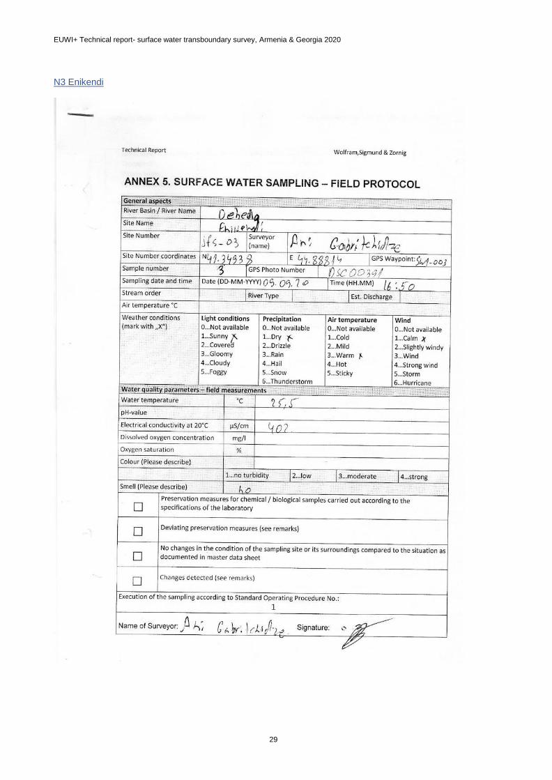
3 Debeda Enikendi 25,5 8,99 85 8,2 402 0,98 1,78 0,384 5,721
4 Khrami Imiri 23,9 6,78 63 8,0 462 1,13 2,18 0,323 4,517
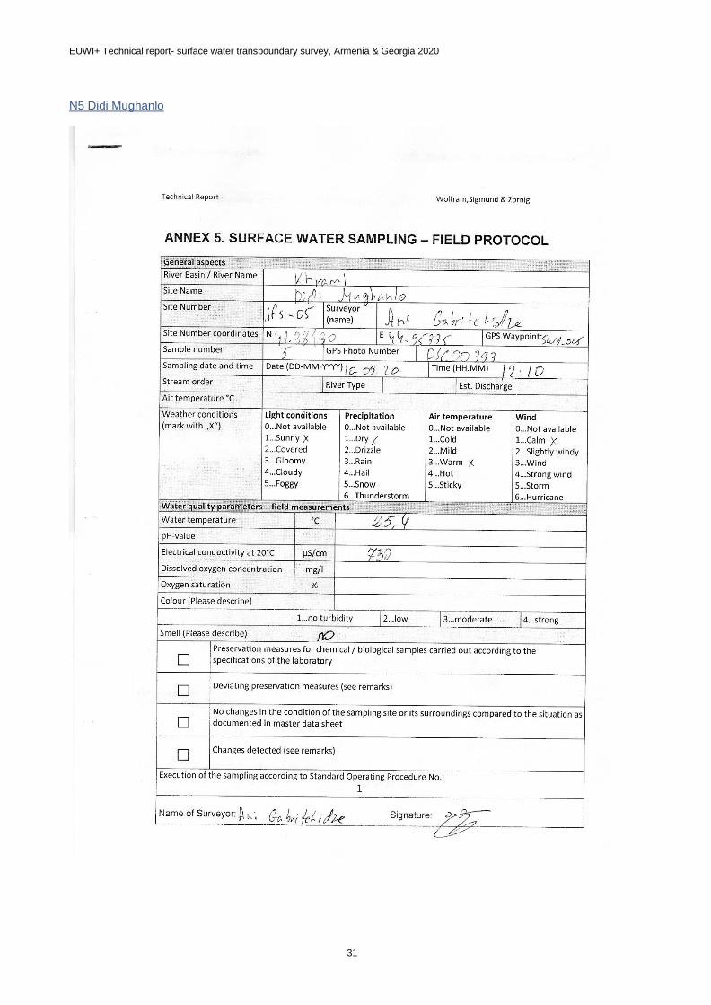
5 Khrami Didi Mughanlo 25,4 10,16 97 8,1 730 1,83 3,56 0,399 5,370
6 Khrami Red Bridge 25,0 10,17 98 8,3 648 1,57 1,98 0,278 4,586
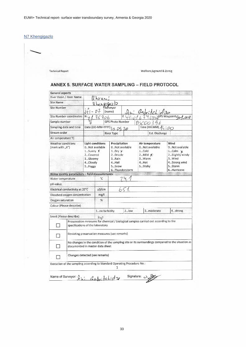
7 Khrami Khangigazlo 24,1 10,29 98 8,3 651 3,61 1,78 0,300 4,715

EUWI+ Technical report- surface water transboundary survey, Armenia & Georgia 2020
20
Table 13: Additional results of the chemical analyses
Nr River Sampling site PO4 TP Ca Mg Na K Cl SO4
Units mg/L mg/L mg/L mg/L mg/L mg/L mg/L mg/L
1 Khrami Tazakendi 0,203 0,320 46,50 13,20 15,38 1,94 4,88 25,83
2 Debeda Kirovka 0,272 0,305 61,95 21,09 38,86 2,42 14,81 93,63
3 Debeda Enikendi 0,338 0,371 75,67 29,41 39,47 3,07 25,74 122,58
4 Khrami Imiri 0,260 0,293 49,05 18,02 20,53 2,14 5,85 34,88
5 Khrami Didi Mughanlo 0,275 0,308 59,52 25,57 22,68 1,99 8,88 60,46
6 Khrami Red Bridge 0,226 0,259 65,32 23,86 34,32 2,98 11,80 91,11
7 Khrami Khangigazlo 0,074 0,100 64,34 22,47 32,40 2,66 12,07 93,45

EUWI+ Technical report- surface water transboundary survey, Armenia & Georgia 2020
21
4.3 Biological analyses
The biological raw data are provided in Annex 7.
According to the AQEM code, 33 different taxa (genus and family level) and 12 major groups appear. At the
7 investigated sites, the taxa richness varies between 6 to 20 taxa per sample, while the abundance ranges
from 41 to 175 individuals. Most dominant genera in the samples are Baetis sp. and Hydropsyche sp.
For all inspected sites, the ecological status is calculated following the Ecological Status Classification
System (ESCS) which has been developed during EUWI+. The ECSC system considers the composition
and abundance of taxa, the ratio of disturbance-sensitive taxa to insensitive taxa, the level of diversity and
the occurrence of major taxonomic groups (EUWI+ RefCond reports).
Five sites indicate a Good Ecological Status. Two sites, one in Debeda river close to the border to Armenia
and a second one on Khrami river, fail to achieve the Good Ecological Status (moderate).
Reason for the status class “moderate” might be the frequent variability in discharge, anthropogenic
deviations in morphology and a flood event just before the field trip. Many sites show a high potential of
riverbed re-arrangement after flood events. The site „Didi Mughanlo“ has a disturbed discharge variability
due to sand and gravel extraction works.
Table 14 The Ecological Status of sampling points according to the biological analyses
River name Site name Site code Nr. of individuals Nr. of taxa nEQR Ecological Status
Debeda Tazakendi JFS-01 175 15 0,54 Moderate
Debeda Kirovka SW2-KHR-10
/ JFS-02
41 6 0,69 Good
Debeda Enikendi JFS-03 89 8 0,74 Good
Khrami Imiri JFS-04 41 8 0,77 Good
Khrami Didi
Mughanlo
JFS-05 110 50 0,70 Good
Khrami Red Bridge JFS-06 50 10 0,73 Good
Khrami Khangigazlo JFS-07 86 20 0,48 Moderate

EUWI+ Technical report- surface water transboundary survey, Armenia & Georgia 2020
22
5 ARMENIAN RESULTS
5.1 Field protocols
The sampling team filled in field protocols (Annex 1) for each surface water sample site. The protocols include
detailed information about the river basin, name and type, site number and coordinates, sampling date and
time, weather and water quality conditions, name of surveyor with signature and other comments, Field
Protocols for 10 sample sites are attached to the report in separate files.
Most of the inspected river sections show no deviation from its natural character and no pressures from
wastewater, transport or other anthropological use. Hydro-morphological conditions were mainly natural or
semi-natural.
5.2 Chemical analyses
Data show a relatively heterogeneous nutrient concentration among the sites. Compared to the other sites,
the site SW-02 (Pambak) shows a low oxygen saturation (<80%) and highest concentrations of NH4, NO3
and phosphorous components. Chloride and sulfate concentrations are also relatively high. Highest sulfate
concentrations were measured at the sites SW-07 (Akhtala) and SW-09 (Shnogh village).
Table 15 Results of chemical analyses at 10 Armenian sampling sites in autumn 2020.
River Basin: Debed
Parameters WT DO O2-Sat pH EC NH4-N NO3-N
Units °C mg/L % µS/cm mg/L mg/L
River Sampling site Sampling date
Chichkhan Shirakamut village 11.09.2020 13,2 9,01 86 8,4 291 0,0621 0,406
Pambak Down to Vanadzor town
10.09.2020 17,6 6,50 68 7,9 610 9,2616 3,941
Sevaberd Katnarat village 11.09.2020 18,6 7,42 79,4 8,2 65 0,1090 <0.011
Dzoraget Dzoraget village 10.09.2020 16,6 9,56 97,9 8,8 273 0,0603 1,197
Jukhtak Marts village 10.09.2020 19 8,40 90,7 8,5 233 0,0793 <0.011
Debed Down to Alaverdi town
10.09.2020 19,9 8,47 93,1 8,7 336 0,1101 2,145
Akhtala Akhtala town 09.09.2020 18,4 8,88 95,1 7,8 1452 0,3978 1,585
Shnogh (Qaratsakh)
Teghut village 09.09.2020 19 8,49 91,6 7,9 508 0,0755 0,018
Shnogh Shnogh village 09.09.2020 22,8 8,54 99,4 8,5 1092 0,2169 1,636
Debed Border, Ptghavan (Bagratashen)
09.09.2020 21,2 11,44 130,1 8,9 406 0,1578 2,096

EUWI+ Technical report- surface water transboundary survey, Armenia & Georgia 2020
23
Table 16 Additonal results of the chemical analyses
River Basin: Debed
Parameters PO4-P TP Cl SO4 Ca Mg Na K
Units mg/L mg/L mg/L mg/L mg/L mg/L mg/L mg/L
River Sampling site Sampling date
Chichkhan Shirakamut village
11.09.2020 0,037 0,064 1,00 6,66 36,76 5,11 6,39 0,89
Pambak Down to Vanadzor town
10.09.2020 0,340 0,532 18,34 47,37 61,90 11,40 27,41 4,35
Sevaberd Katnarat village 11.09.2020 0,014 0,038 0,13 1,32 6,11 1,53 2,64 1,84
Dzoraget Dzoraget village 10.09.2020 0,061 0,075 4,11 12,60 32,81 6,48 7,80 1,62
Jukhtak Marts village 10.09.2020 0,037 0,061 1,23 14,09 32,82 3,69 8,03 1,35
Debed Down to Alaverdi town
10.09.2020 0,098 0,125 7,14 26,38 42,18 6,84 11,75 2,09
Akhtala Akhtala town 09.09.2020 0,037 0,338 13,87 655,45 196,41 41,70 61,98 2,92
Shnogh (Qaratsakh)
Teghut village 09.09.2020 0,061 0,081 2,61 31,62 81,38 14,99 9,20 4,86
Shnogh Shnogh village 09.09.2020 0,061 0,094 11,09 345,88 132,93 23,44 52,17 3,72
Debed Border, Ptghavan
(Bagratashen) 09.09.2020 0,065 0,090 10,10 48,71 49,97 9,56 23,54 3,10
5.3 Biological analyses
Each of the 10 samples was sorted and subsampled, as described in the EUWI+ Manual for Surface Water
Monitoring (EUW+, 2019). The invertebrates were separated to the major taxonomic groups and attributed
to the appropriate taxonomic levels (Annex 7). For all inspected sites, the ecological status was calculated
following the Ecological Status Classification System (ESCS) developed by EUWI+. The ECSC system
considers the composition and abundance of taxa, the ratio of disturbance-sensitive taxa to insensitive taxa,
the level of diversity and the occurrence of major taxonomic groups (EUWI+ RefCond reports).
According to the AQEM code, 45 different taxa (genus and family level) and 12 major groups appear. Among
the 10 investigated sites, the taxa richness varies from 0 to 28 taxa per sample, while the abundance ranges
from 0 to 1034 individuals. Most dominant genera in the samples are Baetidae and Heptageniidae, both in
the same group Ephemeroptera.
Within the Debed River Basin, 5 of the investigated sites indicate a High Ecological Status based on the
macrozoobenthos quality element. One site shows a Good Ecological Status, Four sites fail to achieve the
Good Ecological Status.
Most of the sites with High Ecological Status show a considerable large number of taxa and individuals.
Results are supported by the physico-chemical measurements, which show a low concentration for nutrient
parameters and almost no hydro-morphological deviations from its natural character. At site SW-06, only 100
individuals of 8 MZB families were documented. The low diversity indicates that the resulting High Ecological
Status is not plausible. At site SW-07 no animals were found. This river section bears multiple anthropological
pressures (wastewater, water abstraction) and shows high nutrient concentrations.

EUWI+ Technical report- surface water transboundary survey, Armenia & Georgia 2020
24
Table 17 Results of the biological assessment of the ecological status
River name Site name Site code Nr. of individuals Nr. of taxa nEQR Ecological Status
Chichkhan
Trchkan
waterfall SW-01 28 1034 1,00 high
Pambak Vanadzor SW-02 9 423 0,00 bad
Sevaberd Noramut SW-03 24 1021 1,00 high
Dzoraget River mouth SW-04 18 427 0,63 good
Jukhtak Marts SW-05 18 697 1,00 high
Debed Alaverdi SW-06 8 100 0,86 high
Akhtala Akhtala SW-07 0 0 0,00 bad
Snogh Teghut SW-08 14 134 1,00 high
Snogh Snogh SW-09 9 260 0,24 poor
Debed Border SW-10 6 13 0,52 moderate

EUWI+ Technical report- surface water transboundary survey, Armenia & Georgia 2020
25
6 CONCLUSIONS AND LESSONS LEARNED
For this transboundary surface water survey macroinvertebrates were selected as biological quality
element, together with supporting physico-chemical parameters and hydromorphological elements, as
recommended by the WFD, to provide data for the water body typology evaluation and for the surface water
monitoring design.
Due to the difficult circumstances during the Covid-19 pandemic it was not possible to personally share
national approaches in sampling and field work. Alternatively, simultaneous monitoring was conducted
which partially allows a comparison of results of similar river types at the same seasonal conditions.
The selection of sampling sites allows profound insights into river basins and sections, where monitoring
practice has been sparse and reference conditions are hardly known. Eventually, the field experts came
across a picture of river sections, which was very different from what they expected from the biocenosis.
Proper documentation and discussion in joint reporting need coordination and initiative from both national
teams. Due to a lack of personnel resources, there is still much room for improvement to autonomously fulfill
the reporting requirements in the future.
6.1 Comparison of data and status (according to respective ESCS)
For Georgia, 5 of 7 sites indicate a God Ecological Status. For Armenia, onsite conditions were very
heterogeneous among the selected sites which leads to a wide range of results. In both countries, the
ecological status is low for polluted or disturbed sites (from human impacts like wastewater, water
abstraction and (open cast) mining). Along the border river Debeda/Debed, the species richness is very low
(8 to 6 taxa found in Armenia). Similar metrics were obtained close to the border on Georgian site. At the
sites Kirova and Enikendi, the species richness increase and coherently the ecological status improves.
6.2 Discussion of data deviations
The ESCS (ecological status classification system) developed during EUWI+ is based on type-specific
Reference Conditions. It was applied in the transboundary survey area, although reference conditions were
not established in this area yet. On one hand this served as a practical exercise of biological assessment
and on the other hand the ESCS was tested. As Expert Judgement suggests that the ecological status was
partially evaluated as too high on Georgian territory, it is strongly suggested to further refine the ESCS
and expand it to other river types.
Simultaneously assessed parameters, such as hydro-morphological and chemical conditions, help to identify
specific pressures within this area and explain the response at the biological coenoses (pressure
response). Additionally, inclusion of results of the hydro-morphological and chemical assessments into
plausibility checks of biological data lead to more accurate statements for the ecological status assessment.
Throughout the survey similar taxonomic levels (usually family level) have been applied. Despite the fact,
that different identification keys have been used, taxa lists on family level are comparable among each
other country. The most prominent differences are the number of documented species and individual
numbers. On-site impressions in Georgia reveal frequent changes in discharge and river bed morphology.
Frequent flood events in some valleys might have an impact on invertebrate coenoses, too. Furthermore,
differences between the samples taken at both country territories (Armenia-Georgia) could have been
caused by the different composition of the substrate. A more detailed hydro-morphological assessment
considering hydrological conditions could support the plausibility check of the ecological status based on
invertebrates.

EUWI+ Technical report- surface water transboundary survey, Armenia & Georgia 2020
26
The measurement methods for Ca, Mg, K, Na, total phosphorus and phosphate ions are different. A
comparison of results shows that the deviations are very high. Only the results of Ca and pH have a small
difference. This shows the need for further quality assurance in the laboratories and a harmonization of
methods, where possible. The reasons for deviation are manifold, ranging from sampling site selection,
sampling, lab methodology, data errors etc. This needs to be further investigated and specifically be identified
in future efforts.
6.3 General lessons learned
In light of the pandemic in 2020, all involved institutions are pleased that this pilot transboundary monitoring
could be successfully executed in the Debed RBD.
All field work could be done with sufficient respect for personal safety, especially during the sampling of water
and sediments in deep and fast-flowing river sections or at unstable sediment sites and riverbanks. At two
sites in Georgia accessibility problems arouse and the field team was forced to change the location.
Some conclusions and recommendations can be drawn:
The bilateral monitoring agreement between Armenia and Georgia lays the important ground for
international collaboration, which is then refined by the Guidance document on the joint river
monitoring procedures. It is strongly recommended that these collaborative, transboundary efforts
will be expanded 1) regarding the frequency: towards regular annual joint monitoring and 2) at a
larger geographical scope: at transboundary waterbodies across the entire EaP-region
Careful planning is necessary with a particular focus on weather and hydrological conditions;
samplings shortly after flood events should be avoided.
Adaptations for the field protocol are recommended to better illustrate local hydrological conditions.
Suggestions are to specify macrophytes coverage and to add information on water abstraction and
changes in discharge.
It is recommended to apply plausibility checks for raw data, as well as for the ecological status. If
biodiversity is unexpectedly and implausibly too low, it is necessary to improve sampling techniques
for quality assurance. EUWI+ strongly recommends to follow the AQEM procedure as described in
the EUWI+ surface water manual. Training and knowledge transfer for WFD-compatible sampling
techniques (MHS) could be intensified to gain comparable data on the ecological status.
Photo documentation and adding as much onsite information as possible during field work allows
experts, who have not been physically present on sites, to gain a better insight into the ecological
situation on the territory of either Armenia or Georgia.
For this pilot survey, strong international guidance was needed from the beginning to the conclusion
of the activity. After all, political will, institutional support and personal engagement by national
experts are essential for any successful transboundary cooperation.
In the future, national experts from HMC and NEA need to autonomously cooperate on how to further
achieve quality assurance in transboundary monitoring. Joint surveys and reporting relies on
transparency and good exchange of knowledge and data.
Results from this transboundary survey should be used to improve the ecological status
classification system. For some locations in the basin, adjustments in the classifications might be
necessary, as basin-specific reference conditions are unknown so far.
Nonetheless, a single sample does not allow to identify the ecological status for a larger catchment. A
bilateral monitoring programme on a yearly base should incorporate also other parts of the
Debed/Debeda river basin and reflect seasonal variations. This will increase the quality of and
confidence into joint results.
In general, this survey revealed a fruitful outcome of transnational knowledge and experience transfer
for transboundary river systems. It can become a model across the Eastern Partnership-Region.

EUWI+ Technical report- surface water transboundary survey, Armenia & Georgia 2020
27
ANNEX 1: FIELD PROTOCOLS
Georgia
N1 Tazakendi

EUWI+ Technical report- surface water transboundary survey, Armenia & Georgia 2020
28
N2 Kirovka
EUWI+ Technical report- surface water transboundary survey, Armenia & Georgia 2020
29
N3 Enikendi

EUWI+ Technical report- surface water transboundary survey, Armenia & Georgia 2020
30
N4 Imiri
EUWI+ Technical report- surface water transboundary survey, Armenia & Georgia 2020
31
N5 Didi Mughanlo

EUWI+ Technical report- surface water transboundary survey, Armenia & Georgia 2020
32
N6 Red Bridge
EUWI+ Technical report- surface water transboundary survey, Armenia & Georgia 2020
33
N7 Khengigazlo

EUWI+ Technical report- surface water transboundary survey, Armenia & Georgia 2020
34
Armenia
General aspects
River Basin / River Name Debed / Chichkhan
Site Name Trchkan below
Site Number EUWI+EP 1 Surveyor (name)
Frunzikyan
Site Number coordinates N40.91446 E44.11854 GPS Waypoint:
Sample number EUWI+EP 1 GPS Photo Number -
Sampling date and time Date (DD-MM-YYYY)11-09-2020 Time (HH.MM)15:00
Stream order River Type I Est. Discharge
Air temperature °C 210C
Weather conditions (mark with „X“)
Light conditions 0…Not available 1…X…Sunny 2…Covered 3…Gloomy 4…Cloudy 5…Foggy
Precipitation 0…Not available 1…X…Dry 2…Drizzle 3…Rain 4…Hail 5…Snow 6…Thunderstorm
Air temperature 0…Not available 1…Cold 2…Mild 3…X…Warm 4…Hot 5…Sticky
Wind 0…Not available 1…X…Calm 2…Slightly windy 3…Wind 4…Strong wind 5…Storm 6…Hurricane
Water quality parameters – field measurements
Water temperature °C 13.20C
pH-value 8.44
Electrical conductivity at 20°C µS/cm 291.3
Dissolved oxygen concentration mg/l 9.01
Oxygen saturation % 86%
Colour (Please describe)
Turbidity of water (mark with “X”) 1… X… no turbidity 2…low 3…moderate 4…strong
Turbidity of water NTU 17.2
Smell (Please describe) -
□ Preservation measures for chemical / biological samples carried out according to the specifica- tions of the laboratory
□ Deviating preservation measures (see remarks)
□ No changes in the condition of the sampling site or its surroundings compared to the situation as documented in master data sheet
□ Changes detected (see remarks)
Execution of the sampling according to Standard Operating Procedure No.:
Name of Surveyor: Frunzikyan Signature:

EUWI+ Technical report- surface water transboundary survey, Armenia & Georgia 2020
35
General aspects
River Basin / River Name Debed / Pambak
Site Name Vanadzor below
Site Number EUWI+EP 2 Surveyor (name)
Frunzikyan
Site Number coordinates N40.81389 E44.50758 GPS Waypoint:
Sample number EUWI+EP 2 GPS Photo Number -
Sampling date and time Date (DD-MM-YYYY)10-09-2020 Time (HH.MM) 17:30
Stream order River Type II Est. Discharge
Air temperature °C 270C
Weather conditions (mark with „X“)
Light conditions 0…Not available 1…X…Sunny 2…Covered 3…Gloomy 4…Cloudy 5…Foggy
Precipitation 0…Not available 1…X…Dry 2…Drizzle 3…Rain 4…Hail 5…Snow 6…Thunderstorm
Air temperature 0…Not available 1…Cold 2…Mild 3…Warm 4…X…Hot 5…Sticky
Wind 0…Not available 1…X…Calm 2…Slightly windy 3…Wind 4…Strong wind 5…Storm 6…Hurricane
Water quality parameters – field measurements
Water temperature °C 17.60C
pH-value 7.87
Electrical conductivity at 20°C µS/cm 610
Dissolved oxygen concentration mg/l 6.50
Oxygen saturation % 68%
Colour (Please describe)
Turbidity of water (mark with “X”) 1…no turbidity 2…low 3…X…moderate 4…strong
Turbidity of water NTU 107
Smell (Please describe) 5
□ Preservation measures for chemical / biological samples carried out according to the specifica- tions of the laboratory
□ Deviating preservation measures (see remarks)
□ No changes in the condition of the sampling site or its surroundings compared to the situation as documented in master data sheet
□ Changes detected (see remarks)
Execution of the sampling according to Standard Operating Procedure No.:
Name of Surveyor: Frunzikyan Signature:

EUWI+ Technical report- surface water transboundary survey, Armenia & Georgia 2020
36
General aspects
River Basin / River Name Debed / Sevaberd
Site Name Noramut
Site Number EUWI+EP 3 Surveyor (name)
Frunzikyan
Site Number coordinates N 41.10809 E 44.13766 GPS Waypoint:
Sample number EUWI+EP 3 GPS Photo Number -
Sampling date and time Date (DD-MM-YYYY) 11-09-2020 Time (HH.MM) 10:30
Stream order River Type I Est. Discharge
Air temperature °C 210C
Weather conditions (mark with „X“)
Light conditions 0…Not available 1…Sunny 2…X…Covered 3…Gloomy 4…Cloudy 5…Foggy
Precipitation 0…Not available 1…X…Dry 2…Drizzle 3…Rain 4…Hail 5…Snow 6…Thunderstorm
Air temperature 0…Not available 1…Cold 2… X…Mild 3… Warm 4…Hot 5…Sticky
Wind 0…Not available 1…Calm 2… X…Slightly windy 3…Wind 4…Strong wind 5…Storm 6…Hurricane
Water quality parameters – field measurements
Water temperature °C 18.60C
pH-value 8.23
Electrical conductivity at 20°C µS/cm 64.8
Dissolved oxygen concentration mg/l 7.42
Oxygen saturation % 79.4%
Colour (Please describe) -
Turbidity of water (mark with “X”) 1… X…no turbidity 2…low 3…moderate 4…strong
Turbidity of water NTU 8.1
Smell (Please describe) 0
□ Preservation measures for chemical / biological samples carried out according to the specifica- tions of the laboratory
□ Deviating preservation measures (see remarks)
□ No changes in the condition of the sampling site or its surroundings compared to the situation as documented in master data sheet
□ Changes detected (see remarks)
Execution of the sampling according to Standard Operating Procedure No.:
Name of Surveyor: Frunzikyan Signature:

EUWI+ Technical report- surface water transboundary survey, Armenia & Georgia 2020
37
General aspects
River Basin / River Name Debed / Dzoraget
Site Name River mouth
Site Number EUWI+EP 4 Surveyor (name)
Frunzikyan
Site Number coordinates N 40.95773 E 44.63063 GPS Waypoint:
Sample number EUWI+EP 4 GPS Photo Number -
Sampling date and time Date (DD-MM-YYYY) 10-09-2020 Time (HH.MM) 15:00
Stream order River Type II Est. Discharge
Air temperature °C 310C
Weather conditions (mark with „X“)
Light conditions 0…Not available 1…X…Sunny 2…Covered 3…Gloomy 4…Cloudy 5…Foggy
Precipitation 0…Not available 1…X…Dry 2…Drizzle 3…Rain 4…Hail 5…Snow 6…Thunderstorm
Air temperature 0…Not available 1…Cold 2…Mild 3…Warm 4…X…Hot 5…Sticky
Wind 0…Not available 1…Calm 2…X…Slightly windy 3…Wind 4…Strong wind 5…Storm 6…Hurricane
Water quality parameters – field measurements
Water temperature °C 16.60C
pH-value 8.77
Electrical conductivity at 20°C µS/cm 272.8
Dissolved oxygen concentration mg/l 9.56
Oxygen saturation % 97.9%
Colour (Please describe) -
Turbidity of water (mark with “X”) 1…X…no turbidity 2…low 3…moderate 4…strong
Turbidity of water NTU 4.2
Smell (Please describe)
□ Preservation measures for chemical / biological samples carried out according to the specifica- tions of the laboratory
□ Deviating preservation measures (see remarks)
□ No changes in the condition of the sampling site or its surroundings compared to the situation as documented in master data sheet
□ Changes detected (see remarks)
Execution of the sampling according to Standard Operating Procedure No.:
Name of Surveyor: Frunzikyan Signature:

EUWI+ Technical report- surface water transboundary survey, Armenia & Georgia 2020
38
General aspects
River Basin / River Name Debed / Jukhtak
Site Name Above village Marc
Site Number EUWI+EP 5 Surveyor (name)
Frunzikyan
Site Number coordinates N 40.92114 E 44.72702 GPS Waypoint:
Sample number EUWI+EP 5 GPS Photo Number -
Sampling date and time Date (DD-MM-YYYY) 10-09-2020 Time (HH.MM) 12:00
Stream order River Type I Est. Discharge
Air temperature °C 280C
Weather conditions (mark with „X“)
Light conditions 0…Not available 1…X…Sunny 2…Covered 3…Gloomy 4…Cloudy 5…Foggy
Precipitation 0…Not available 1…X…Dry 2…Drizzle 3…Rain 4…Hail 5…Snow 6…Thunderstorm
Air temperature 0…Not available 1…Cold 2…Mild 3…X…Warm 4…Hot 5…Sticky
Wind 0…Not available 1…X…Calm 2…Slightly windy 3…Wind 4…Strong wind 5…Storm 6…Hurricane
Water quality parameters – field measurements
Water temperature °C 190C
pH-value 8.49
Electrical conductivity at 20°C µS/cm 233.2
Dissolved oxygen concentration mg/l 8.40
Oxygen saturation % 90.7
Colour (Please describe) -
Turbidity of water (mark with “X”) 1…X…no turbidity 2…low 3…moderate 4…strong
NTU 6.1
Smell (Please describe)
□ Preservation measures for chemical / biological samples carried out according to the specifica- tions of the laboratory
□ Deviating preservation measures (see remarks)
□ No changes in the condition of the sampling site or its surroundings compared to the situation as documented in master data sheet
□ Changes detected (see remarks)
Execution of the sampling according to Standard Operating Procedure No.:
Name of Surveyor: Frunzikyan Signature:

Surface Water Survey Manual EUWI+: General manual for biological survey
36
General aspects
River Basin / River Name Debed / Debed
Site Name Alaverdi
Site Number EUWI+EP 6 Surveyor (name)
Frunzikyan
Site Number coordinates N 41.09593 E 44.67558 GPS Waypoint:
Sample number EUWI+EP 6 GPS Photo Number -
Sampling date and time Date (DD-MM-YYYY) 10-09-2020 Time (HH.MM) 9:00
Stream order River Type III Est. Discharge
Air temperature °C 320C
Weather conditions (mark with „X“)
Light conditions 0…Not available 1…X…Sunny 2…Covered 3…Gloomy 4…Cloudy 5…Foggy
Precipitation 0…Not available 1…X…Dry 2…Drizzle 3…Rain 4…Hail 5…Snow 6…Thunderstorm
Air temperature 0…Not available 1…Cold 2…Mild 3…X…Warm 4…Hot 5…Sticky
Wind 0…Not available 1…Calm 2…X…Slightly windy 3…Wind 4…Strong wind 5…Storm 6…Hurricane
Water quality parameters – field measurements
Water temperature °C 19.90C
pH-value 8.69
Electrical conductivity at 20°C µS/cm 336.3
Dissolved oxygen concentration mg/l 8.47
Oxygen saturation % 93.1%
Colour (Please describe) -
Turbidity of water (mark with “X”) 1…no turbidity 2…X…low 3…moderate 4…strong
Turbidity of water NTU 19.4
Smell (Please describe) -
□ Preservation measures for chemical / biological samples carried out according to the specifica- tions of the laboratory
□ Deviating preservation measures (see remarks)
□ No changes in the condition of the sampling site or its surroundings compared to the situation as documented in master data sheet
□ Changes detected (see remarks)
Execution of the sampling according to Standard Operating Procedure No.:
Name of Surveyor: Frunzikyan Signature:
Surface Water Survey Manual EUWI+: General manual for biological survey
37
General aspects
River Basin / River Name Debed / Akhtala
Site Name River Mouth
Site Number EUWI+EP 7 Surveyor (name)
Frunzikyan
Site Number coordinates N 41.14942 E 44.78176 GPS Waypoint:
Sample number EUWI+EP 7 GPS Photo Number -
Sampling date and time Date (DD-MM-YYYY) 09-09-2020 Time (HH.MM) 17:15
Stream order River Type I Est. Discharge
Air temperature °C 240C
Weather conditions (mark with „X“)
Light conditions 0…Not available 1…X…Sunny 2…Covered 3…Gloomy 4…Cloudy 5…Foggy
Precipitation 0…Not available 1…X…Dry 2…Drizzle 3…Rain 4…Hail 5…Snow 6…Thunderstorm
Air temperature 0…Not available 1…Cold 2…Mild 3…Warm 4…X…Hot 5…Sticky
Wind 0…Not available 1… X…Calm 2…Slightly windy 3…Wind 4…Strong wind 5…Storm 6…Hurricane
Water quality parameters – field measurements
Water temperature °C 18.40C
pH-value 7.83
Electrical conductivity at 20°C µS/cm 1452
Dissolved oxygen concentration mg/l 8.88
Oxygen saturation % 95.1%
Colour (Please describe)
Turbidity of water (mark with “X”) 1… no turbidity 2…low 3…moderate 4… X…strong
Turbidity of water NTU 410
Smell (Please describe) 5
□ Preservation measures for chemical / biological samples carried out according to the specifica- tions of the laboratory
□ Deviating preservation measures (see remarks)
□ No changes in the condition of the sampling site or its surroundings compared to the situation as documented in master data sheet
□ Changes detected (see remarks)
Execution of the sampling according to Standard Operating Procedure No.:
Name of Surveyor: Frunzikyan Signature:
Surface Water Survey Manual EUWI+: General manual for biological survey
38
General aspects
River Basin / River Name Debed / Shnogh
Site Name Teghut
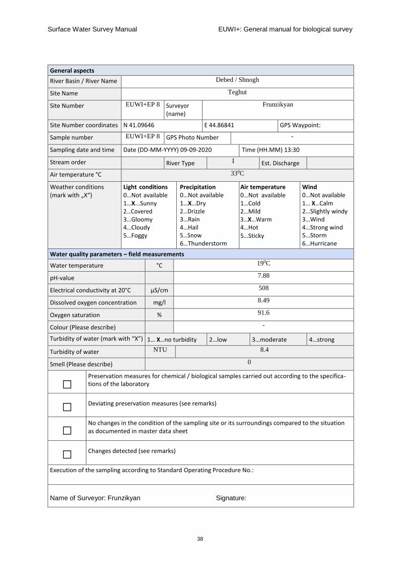
Site Number EUWI+EP 8 Surveyor (name)
Frunzikyan
Site Number coordinates N 41.09646 E 44.86841 GPS Waypoint:
Sample number EUWI+EP 8 GPS Photo Number -
Sampling date and time Date (DD-MM-YYYY) 09-09-2020 Time (HH.MM) 13:30
Stream order River Type I Est. Discharge
Air temperature °C 330C
Weather conditions (mark with „X“)
Light conditions 0…Not available 1…X...Sunny 2…Covered 3…Gloomy 4…Cloudy 5…Foggy
Precipitation 0…Not available 1…X…Dry 2…Drizzle 3…Rain 4…Hail 5…Snow 6…Thunderstorm
Air temperature 0…Not available 1…Cold 2…Mild 3…X…Warm 4…Hot 5…Sticky
Wind 0…Not available 1… X…Calm 2…Slightly windy 3…Wind 4…Strong wind 5…Storm 6…Hurricane
Water quality parameters – field measurements
Water temperature °C 190C
pH-value 7.88
Electrical conductivity at 20°C µS/cm 508
Dissolved oxygen concentration mg/l 8.49
Oxygen saturation % 91.6
Colour (Please describe) -
Turbidity of water (mark with “X”) 1… X…no turbidity 2…low 3…moderate 4…strong
Turbidity of water NTU 8.4
Smell (Please describe) 0
□ Preservation measures for chemical / biological samples carried out according to the specifica- tions of the laboratory
□ Deviating preservation measures (see remarks)
□ No changes in the condition of the sampling site or its surroundings compared to the situation as documented in master data sheet
□ Changes detected (see remarks)
Execution of the sampling according to Standard Operating Procedure No.:
Name of Surveyor: Frunzikyan Signature:

Surface Water Survey Manual EUWI+: General manual for biological survey
39
General aspects
River Basin / River Name Shnogh
Site Name River mouth
Site Number EUWI+EP 9 Surveyor (name)
Frunzikyan
Site Number coordinates N 41.14367 E 44.83287 GPS Waypoint:
Sample number EUWI+EP 9 GPS Photo Number -
Sampling date and time Date (DD-MM-YYYY) 09-09-2020 Time (HH.MM) 15:30
Stream order River Type II Est. Discharge
Air temperature °C 350C
Weather conditions (mark with „X“)
Light conditions 0…Not available 1…X…Sunny 2…Covered 3…Gloomy 4…Cloudy 5…Foggy
Precipitation 0…Not available 1…X…Dry 2…Drizzle 3…Rain 4…Hail 5…Snow 6…Thunderstorm
Air temperature 0…Not available 1…Cold 2…Mild 3…X…Warm 4…Hot 5…Sticky
Wind 0…Not available 1…Calm 2… X…Slightly windy 3…Wind 4…Strong wind 5…Storm 6…Hurricane
Water quality parameters – field measurements
Water temperature °C 22.80C
pH-value 8.45
Electrical conductivity at 20°C µS/cm 1092
Dissolved oxygen concentration mg/l 8.54
Oxygen saturation % 99.4%
Colour (Please describe) -
Turbidity of water (mark with “X”) 1…no turbidity 2… X…low 3…moderate 4…strong
Turbidity of water NTU 23.8
Smell (Please describe) 2
□ Preservation measures for chemical / biological samples carried out according to the specifica- tions of the laboratory
□ Deviating preservation measures (see remarks)
□ No changes in the condition of the sampling site or its surroundings compared to the situation as documented in master data sheet
□ Changes detected (see remarks)
Execution of the sampling according to Standard Operating Procedure No.:
Name of Surveyor: Frunzikyan Signature:

Surface Water Survey Manual EUWI+: General manual for biological survey
40
General aspects
River Basin / River Name Debed / Debed
Site Name On border
Site Number EUWI+EP 10 Surveyor (name)
Frunzikyan
Site Number coordinates N 41.21916 E 44.86566 GPS Waypoint:
Sample number EUWI+EP 10 GPS Photo Number -
Sampling date and time Date (DD-MM-YYYY) 09-09-2020 Time (HH.MM) 11:00
Stream order River Type III Est. Discharge
Air temperature °C 350C
Weather conditions (mark with „X“)
Light conditions 0…Not available 1…X…Sunny 2…Covered 3…Gloomy 4…Cloudy 5…Foggy
Precipitation 0…Not available 1…X…Dry 2…Drizzle 3…Rain 4…Hail 5…Snow 6…Thunderstorm
Air temperature 0…Not available 1…Cold 2…Mild 3…X…Warm 4…Hot 5…Sticky
Wind 0…Not available 1…X…Calm 2…Slightly windy 3…Wind 4…Strong wind 5…Storm 6…Hurricane
Water quality parameters – field measurements
Water temperature °C 21.20C
pH-value 8.88
Electrical conductivity at 20°C µS/cm 405.8
Dissolved oxygen concentration mg/l 11.44
Oxygen saturation % 130.1
Colour (Please describe) -
Turbidity of water (mark with “X”) 1…no turbidity 2…X…low 3…moderate 4…strong
NTU 27.1
Smell (Please describe)
□ Preservation measures for chemical / biological samples carried out according to the specifica- tions of the laboratory
□ Deviating preservation measures (see remarks)
□ No changes in the condition of the sampling site or its surroundings compared to the situation as documented in master data sheet
□ Changes detected (see remarks)
Execution of the sampling according to Standard Operating Procedure No.:
Name of Surveyor: Frunzikyan Signature:

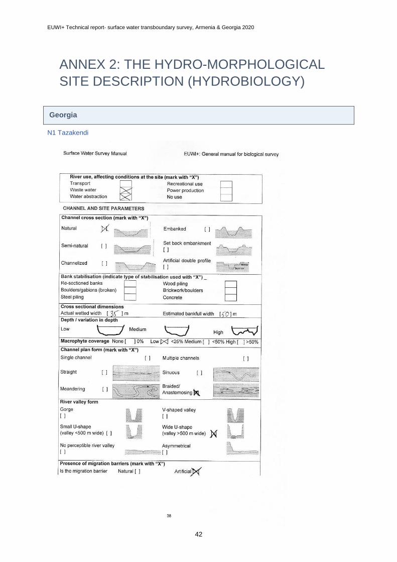
EUWI+ Technical report- surface water transboundary survey, Armenia & Georgia 2020
42
ANNEX 2: THE HYDRO-MORPHOLOGICAL
SITE DESCRIPTION (HYDROBIOLOGY)
Georgia
N1 Tazakendi

EUWI+ Technical report- surface water transboundary survey, Armenia & Georgia 2020
43

EUWI+ Technical report- surface water transboundary survey, Armenia & Georgia 2020
44
N2 Kirovka

EUWI+ Technical report- surface water transboundary survey, Armenia & Georgia 2020
45
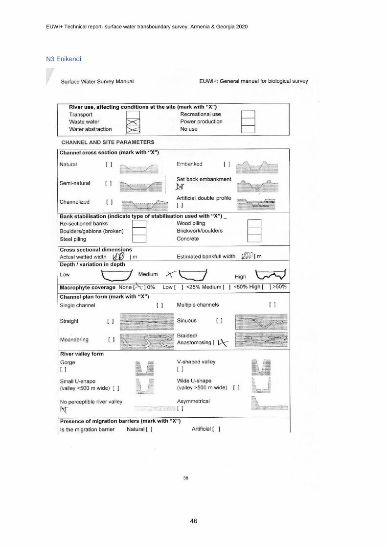
EUWI+ Technical report- surface water transboundary survey, Armenia & Georgia 2020
46
N3 Enikendi

EUWI+ Technical report- surface water transboundary survey, Armenia & Georgia 2020
47
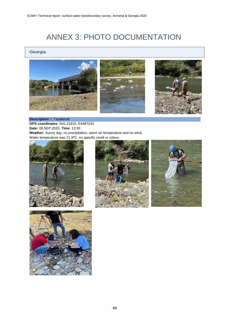
EUWI+ Technical report- surface water transboundary survey, Armenia & Georgia 2020
48
ANNEX 3: PHOTO DOCUMENTATION
-Georgia
Description: I, Tazakendi
GPS coordinates: N41,21816, E4487243
Date: 09,SEP,2020, Time: 13:30
Weather: Sunny day, no precipitation, warm air temperature and no wind,
Water temperature was 21,9ºC, no specific smell or colour,

EUWI+ Technical report- surface water transboundary survey, Armenia & Georgia 2020
49
Description: II, Kirovka
GPS coordinates: N41,27774, E44,80710
Date: 09,SEP,2020, Time: 14:55
Weather: Sunny day, no precipitation, warm air temperature and no wind,
Water temperature was 22,9ºC, no specific smell or colour,

EUWI+ Technical report- surface water transboundary survey, Armenia & Georgia 2020
50
Description: III, Enikendi
GPS coordinates: N41,34938, E44,88814
Date: 09,SEP,2020, Time: 16:50
Weather: Sunny day, no precipitation, warm air temperature and no wind,
Water temperature was 25,5ºC, no specific smell or colour,

EUWI+ Technical report- surface water transboundary survey, Armenia & Georgia 2020
51
Description: IV, Imiri
GPS coordinates: N41,40916, E44,82309
Date: 09,SEP,2020, Time: 17:50
Weather: Sunny day, no precipitation, mild air temperature and no wind,
Water temperature was 23,9ºC, no specific smell or colour,

EUWI+ Technical report- surface water transboundary survey, Armenia & Georgia 2020
52

EUWI+ Technical report- surface water transboundary survey, Armenia & Georgia 2020
53
Description: V, Didi Mughanlo
GPS coordinates: N41,38130, E44,95335
Date: 10,SEP,2020, Time: 12:10
Weather: Sunny day, no precipitation, warm air temperature and no wind,
Water temperature was 25,4ºC, no specific smell or colour,

EUWI+ Technical report- surface water transboundary survey, Armenia & Georgia 2020
54

EUWI+ Technical report- surface water transboundary survey, Armenia & Georgia 2020
55
Description: VI, Red Bridge
GPS coordinates: N41,33335, E44,06750
Date: 10,SEP,2020, Time: 13:15
Weather: Sunny day, no precipitation, warm air temperature
and no wind,
Water temperature was 25,0ºC, no specific smell or colour,

EUWI+ Technical report- surface water transboundary survey, Armenia & Georgia 2020
56
Description: VII, Khangigazlo
GPS coordinates: N41,35306, E45,01634
Date: 10,SEP,2020, Time: 14:00
Weather: Sunny day, no precipitation, mild air
temperature and no wind,
Water temperature was 25,0ºC, no specific
smell or colour,

EUWI+ Technical report- surface water transboundary survey, Armenia & Georgia 2020
57
Armenia

EUWI+ Technical report- surface water transboundary survey, Armenia & Georgia 2020
58
ANNEX 4: CHEMICAL DATA SUMMARY
Georgia
Armenia
Nr Parameter WT DO O2-Sat pH EC BOD5 COD NH4-N NO3-N
Sampling site River Units °C mg/L % µg/cm mg/L mg/L mg/L mg/L
1 JFS-01 Debeda Tazakendi 21,9 9,06 86 8 338 1,47 2,97 0,486 5,374
2 SW2-KHR-10/JFS-02Debeda Kirovka 22,9 8,48 80 8,1 450 1,13 1,98 0,307 5,794
3 JFS-03 Debeda Enikendi 25,5 8,99 85 8,2 402 0,98 1,78 0,384 5,721
4 JFS-04 Khrami Imiri 23,9 6,78 63 8 462 1,13 2,18 0,323 4,517
5 JFS-05 KhramiDidi
Mughanlo25,4 10,16 97 8,1 730 1,83 3,56 0,399 5,37
6 JFS-06 Khrami Red Bridge 25 10,17 98 8,3 648 1,57 1,98 0,278 4,586
7 JFS-07 Khrami Khangigazlo 24,1 10,29 98 8,3 651 3,61 1,78 0,3 4,715
Nr Parameter PO4 TP Ca Mg Na K Cl SO4
Sampling site River Units mg/L mg/L mg/L mg/L mg/L mg/L mg/L mg/L
1 JFS-01 Debeda Tazakendi 0,203 0,32 46,5 13,2 15,38 1,94 4,88 25,83
2 SW2-KHR-10/JFS-02Debeda Kirovka 0,272 0,305 61,95 21,09 38,86 2,42 14,81 93,63
3 JFS-03 Debeda Enikendi 0,338 0,371 75,67 29,41 39,47 3,07 25,74 122,58
4 JFS-04 Khrami Imiri 0,26 0,293 49,05 18,02 20,53 2,14 5,85 34,88
5 JFS-05 KhramiDidi
Mughanlo0,275 0,308 59,52 25,57 22,68 1,99 8,88 60,46
6 JFS-06 Khrami Red Bridge 0,226 0,259 65,32 23,86 34,32 2,98 11,8 91,11
7 JFS-07 Khrami Khangigazlo 0,074 0,1 64,34 22,47 32,4 2,66 12,07 93,45
Physicochemical data for surface water quality from the Debed River Basin, September 2020Basin, September 2020
River Basin: DebedParameters WT DO O2-Sat pH EC NH4-N NO3-N PO4-P TP Cl SO4 Ca Mg Na K
Units °C mg/L % µS/c
m
mg/L mg/L mg/L mg/L mg/L mg/L mg/L mg/L mg/L mg/L
River Sampling site Sampling date
Chichkhan Shirakamut village 11.09.2020 13,2 9,01 86 8,4 291 0,0621 0,406 0,037 0,064 1,00 6,66 36,76 5,11 6,39 0,89
Pambak Down to Vanadzor town 10.09.2020 17,6 6,50 68 7,9 610 9,2616 3,941 0,340 0,532 18,34 47,37 61,90 11,40 27,41 4,35
Sevaberd Katnarat village (Field blank) 11.09.2020 18,6 _ _ _ _ 0,0409 <0.011 0,009 <0.01 <0.05 0,25 0,07 <0.01 <0.01 <0.01
Sevaberd Katnarat village 11.09.2020 18,6 7,42 79,4 8,2 65 0,1090 <0.011 0,014 0,038 0,13 1,32 6,11 1,53 2,64 1,84
Dzoraget Dzoraget village 10.09.2020 16,6 9,56 97,9 8,8 273 0,0603 1,197 0,061 0,075 4,11 12,60 32,81 6,48 7,80 1,62
Jukhtak Marts village 10.09.2020 19 8,40 90,7 8,5 233 0,0793 <0.011 0,037 0,061 1,23 14,09 32,82 3,69 8,03 1,35
Debed Down to Alaverdi town 10.09.2020 19,9 8,47 93,1 8,7 336 0,1101 2,145 0,098 0,125 7,14 26,38 42,18 6,84 11,75 2,09
Akhtala Akhtala town 09.09.2020 18,4 8,88 95,1 7,8 1452 0,3978 1,585 0,037 0,338 13,87 655,45 196,41 41,70 61,98 2,92Shnogh
(Qaratsakh)Teghut village 09.09.2020 19 8,49 91,6 7,9 508 0,0755 0,018 0,061 0,081 2,61 31,62 81,38 14,99 9,20 4,86
Shnogh Shnogh village 09.09.2020 22,8 8,54 99,4 8,5 1092 0,2169 1,636 0,061 0,094 11,09 345,88 132,93 23,44 52,17 3,72
Border, Ptghavan (Bagratashen) (Field blank)09.09.2020 21,2 _ _ _ _ <0.005 <0.011 0,009 <0.01 <0.05 <0.25 0,05 <0.01 <0.01 <0.01
Debed Border, Ptghavan (Bagratashen) 09.09.2020 21,2 11,44 130,1 8,9 406 0,1578 2,096 0,065 0,090 10,10 48,71 49,97 9,56 23,54 3,10
Deputy Director of Hydrometeorology and Monitoring Center SNCO G. Shahnazaryan
Head of Surface Water Quality Monitoring Service A. Zurnachyan

EUWI+ Technical report- surface water transboundary survey, Armenia & Georgia 2020
59
ANNEX 5: CHEMICAL DATA CERTIFICATE
FORMAT
See separate documents.
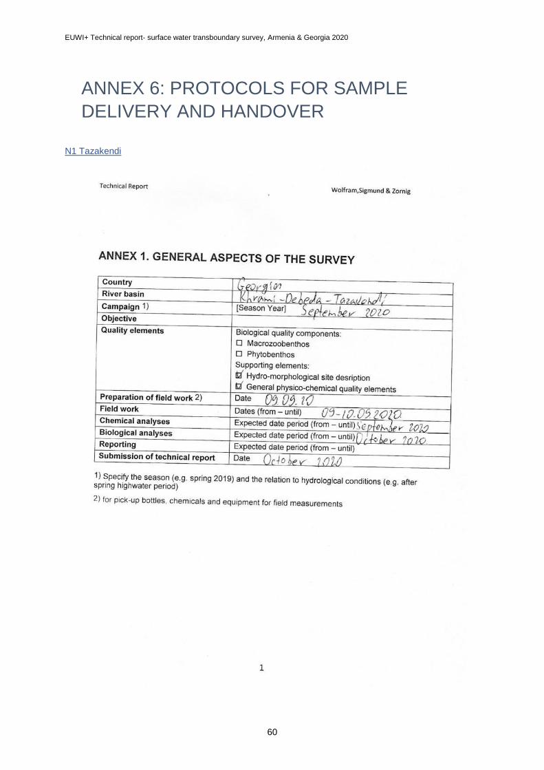
EUWI+ Technical report- surface water transboundary survey, Armenia & Georgia 2020
60
ANNEX 6: PROTOCOLS FOR SAMPLE
DELIVERY AND HANDOVER
N1 Tazakendi

EUWI+ Technical report- surface water transboundary survey, Armenia & Georgia 2020
61
N2 Kirovka

EUWI+ Technical report- surface water transboundary survey, Armenia & Georgia 2020
62
N3 Enikendi

EUWI+ Technical report- surface water transboundary survey, Armenia & Georgia 2020
63

EUWI+ Technical report- surface water transboundary survey, Armenia & Georgia 2020
64
ANNEX 7: BIOLOGICAL DATA SUMMARY
Georgia
See separate attachment in Excel format

EUWI+ Technical report- surface water transboundary survey, Armenia & Georgia 2020
65
Armenia
Family Species
Ընտանիք Տեսակ site 1 Site 2 site 3 site 4 Site 5 Site 6 Site 7 Site 8 Site 9 Site 10
Baetidae 95 115 55 167 170 34 12 1
Heptageniidae 56 64 473 56 10 30
Heptageniidae Epeorus 4 5
Ephemerellidae 1 1
Caenidae 2
Blephariceridae 2 1 5
Chironomidae 64 17 23 11 5 124 6
Chironomidae Chironominae 4 39 5 98
Tabanidae 1 1
Tipulidae 2 3 3 2 1
Ceratopogonidae 4 6
Simuliidae 182 5 1 93 1 7 14
Stratiomyidae 1
Dixidae 1 1 2
Athericidae 1 1 29
Limoniidae 2 34 1 1 4
Dolichopodidae 4
Brachycentridae 95 1 6 1
Brachycentridae Brachycentrus 21 1 16
Glossosomatidae 1 1
Ptychopteridae 2
Hydropsychidae 120 6 163 18 51 29 1 16 1
Hydroptilidae 53 1
Limnephilidae 16 24 1
Leptoceridae 46 10 3
Rhyacophilidae 25 1 16 4 6 1
Sericostomatidae 1 1
Perlidae 32 104 83 14
Chloroperlidae 2 33 13
Capniidae 11 3 66 8
Gerridae 3
Elmidae 210 73 61 9 2
Planorbidae Gyraulus 1 14
Sphaeriidae Pisidium 1 1
Planorbidae Ancylus fluviatilis 33 6
Lymnaeidae Radix peregra 2
Erpobdellidae Erpobdella octoculata 1 1 1
Lumbricidae 1 189
Lumbricidae Eiseniella tetraedra 7 2
Naididae 5
Planariidae Planaria 7 20
Planariidae Polycelis nigra 1
Gammaridae Gammarus 60 40 80 94 2 2
Tetragnathidae Tetragnatha extensa 2
Number of individuals

EUWI+ Technical report- surface water transboundary survey, Armenia & Georgia 2020
66
ANNEX 8: MHS FIELD TABLES
See separate attachment(s) in JPG format or Excel format
N1 Tazakendi

EUWI+ Technical report- surface water transboundary survey, Armenia & Georgia 2020
67
N2 Kirovka
N3 Enikendi

EUWI+ Technical report- surface water transboundary survey, Armenia & Georgia 2020
68
Annex 9: Metadata

EUWI+ Technical report- surface water transboundary survey, Armenia & Georgia 2020
69
www.euwipluseast.eu


