Approved by Edmonton City Council on February 15, 2012 in tandem with City Policy C565 GUIDELINES Transit Oriented Development Prepared by the City of Edmonton Sustainable Development and Transportation Services Departments
Transcript
Approved by Edmonton City Council on February 15, 2012 in tandem with CityPolicy C565
GUIDELINESTransit Oriented Development
Prepared by the City of Edmonton Sustainable Development and Transportation Services Departments
Applying the Guidelines......................................................................................................................................................3
Station Area Types.................................................................................................................................................................9
Station Area Characteristics..............................................................................................................................................11
TOD Guidelines
Land Use and Intensity Guidelines...................................................................................................................................15
Building and Site Design Guidelines...............................................................................................................................26
Public Realm Guidelines - Block.......................................................................................................................................34
Public Realm Guidelines - Public Boulevard..................................................................................................................38
Public Realm Guidelines - Urban Park and Plaza..........................................................................................................42
Public Realm Guidelines - Bicycle Facilities...................................................................................................................44
Public Realm Guidelines - Roadway.................................................................................................................................49
Urban Design and CPTED Principles...............................................................................................................................53
The Transit Oriented Development (TOD) Guidelines identify appropriate transit oriented development around LRT stations and transit centres. They assist the City, businesses and citizens to plan ahead for the integration of transit and land use in station areas.
The Guidelines align with The Way Ahead, Edmonton’s Strategic Plan; The Way We Grow, Edmonton’s Municipal Development Plan; The Way We Move, Edmonton’s Transportation Plan; The Way We Green, Edmonton’s Environmental Plan; and, The Way We Live, Edmonton’s People Plan, aiding Edmonton’s 30 year agenda to:
The Guidelines will be used to communicate the City’s expectations and to assess rezoning or planning proposals by property owners, developers and their designers.
Additonal context for the Guidelines can be found in the Technical Report: Transit Oriented Development Guidelines, prepared by the City of Edmonton Sustainable Development and Transportation Services Departments, November 2011.
2
LAND USE AND INTENSITY GUIDELINES AND DESCRIPTIONS
BUILDING AND SITE DESIGN GUIDELINES AND DESCRIPTIONS
PUBLIC REALM GUIDELINES
BLOCK GUIDELINES AND DESCRIPTIONS
PUBLIC BOULEVARD GUIDELINES AND DESCRIPTIONS
URBAN PARK AND PLAZAGUIDELINES AND DESCRIPTIONS
BICYCLE FACILITIESGUIDELINES AND DESCRIPTIONS
ROADWAYGUIDELINES AND DESCRIPTIONS
URBAN DESIGN AND CRIME PREVENTION THROUGH ENVIRONMENTAL DESIGN
(CPTED) PRINCIPLES
GUIDELINE ORGANIZATION
LAND USE & INTENSITY GUIDELINES Land Use and Intensity Guidelines–identify minimum and maximum land use expectations for new allowable uses and Station Area Plans; all residential densities and employment intensities are net area calculations.
BUILDING & SITE DESIGN GUIDELINES Building and Site Design Guidelines–describe qualities that foster the desired relationship between buildings and the street and provide appropriate transitions between shorter and taller buildings.
PUBLIC REALM GUIDELINESThe public realm is fundamental to the success of TOD. A quality public realm attracts and stabilizes private investment and ensures consistency throughout the station area. Public Realm Guidelines may be initiated by the City of Edmonton or by private developers. They include:
Block Guidelines– identify maximum block dimensions and confi guration expectations.
Public Boulevard Guidelines–identify minimum dimensions, restrictions and pedestrian components required for new and improved public streets.
Urban Park and Plaza Guidelines–identify sizes of public urban parks and plazas, and the types of amenities.
Bicycle Facilities Guidelines–identify bicycle parking and travel route types required for new and improved public streets.
Roadway Guidelines–identify roadway elements required for new and improved public streets .
URBAN DESIGN AND CPTED PRINCIPLES
Urban Design and CPTED Principles–describe qualities that encourage appropriate design quality and reduce the potential for crime in station areas.
The TOD Guideline tables (pages 15 to 54) are organized under the following four categories:
• Land Use and Intensity Guidelines
• Building and Site Design Guideines
• Public Realm Guidelines
• Urban Design and CPTED Principles
Land Use and Intensity Guidelines are unique for each station area type. Building and Site Design Guidelines, Public Realm Guidelines and Urban Design and CPTED Principles are universal for all station area types.
For each category of guidelines and principles, descriptions are also provided for explanatory and educational purposes.
Figure 1: Organization of TOD Guidelines
3
HOW TO APPLY GUIDELINES
The TOD Guidelines will be used in four ways.
Land Use and Intensity GuidelinesThe TOD Guidelines will be used to evaluate rezoning applications on sites within 400 metres of existing or planned LRT stations or transit centres. In these situations, the Land Use Type and Intensity Guidelines will be used to evaluate whether the proposed location and intensity of the development are appropriate, based on the Station Type. The Land Use Type and Intensity Guidelines also provide land use expectations. These will be used in preparing and amending Statutory Plans for Station Areas both in infi ll and greenfi eld situations within 800 metres of the existing or planned stations.
When applying the Land Use and Intensit y Guidelines, the size of the site takes precedence over the location of the site when determining residential density.
Building and Site Design GuidelinesThe TOD Guidelines will be applied to the creation of new zones and overlays, or the modification of existing zones and overlays within the zoning bylaw. They refl ect site and building design criteria appropriate for development around station areas. The Building and Site Design Guidelines will provide direction on what additional or new regulations should be included in:
Standard zones
Direct control zones
Special area zones.
These can be applied to sites around LRT stations or transit centres.
APPLYING THE GUIDELINES
Public Realm GuidelinesThe TOD Guidelines will be used as a basis for rezoning large sites greater than or equal to one hectare, or creating new or amending statutory plans within 800 metres of an LRT station or 400 metres of a transit centre. The exact boundaries of the station area plan will vary from the 800-metre radius—especially for infi ll stations—depending on existing uses, development potential and other factors. The TOD Guidelines will be used in these situations to direct the location and design of elements in the Public Realm. This includes:
Streets
Block size
Pedestrian and bicycle connections
Urban parks
Plazas
Urban Design and CPTED PrinciplesThe TOD Urban Design and CPTED Principles will be universally applied for all projects within the Station Areas of existing or planned LRT stations or transit centres.
4
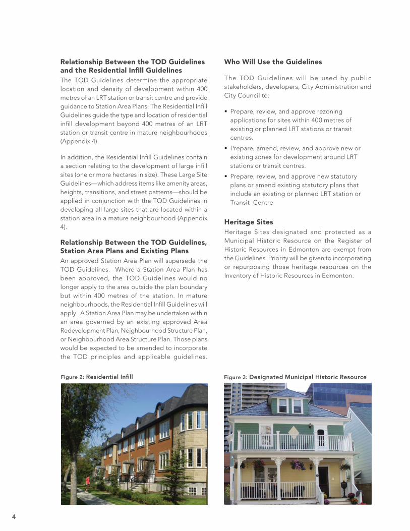
Figure 3: Designated Municipal Historic Resource
Relationship Between the TOD Guidelines and the Residential Infi ll GuidelinesThe TOD Guidelines determine the appropriate location and density of development within 400 metres of an LRT station or transit centre and provide guidance to Station Area Plans. The Residential Infi ll Guidelines guide the type and location of residential infi ll development beyond 400 metres of an LRT station or transit centre in mature neighbourhoods (Appendix 4).
In addition, the Residential Infi ll Guidelines contain a section relating to the development of large infi ll sites (one or more hectares in size). These Large Site Guidelines—which address items like amenity areas, heights, transitions, and street patterns—should be applied in conjunction with the TOD Guidelines in developing all large sites that are located within a station area in a mature neighbourhood (Appendix 4).
Relationship Between the TOD Guidelines, Station Area Plans and Existing PlansAn approved Station Area Plan will supersede the TOD Guidelines. Where a Station Area Plan has been approved, the TOD Guidelines would no longer apply to the area outside the plan boundary but within 400 metres of the station. In mature neighbourhoods, the Residential Infi ll Guidelines will apply. A Station Area Plan may be undertaken within an area governed by an existing approved Area Redevelopment Plan, Neighbourhood Structure Plan, or Neighbourhood Area Structure Plan. Those plans would be expected to be amended to incorporate the TOD principles and applicable guidelines.
Who Will Use the Guidelines
The TOD Guidelines will be used by public stakeholders, developers, City Administration and City Council to:
Prepare, review, and approve rezoning applications for sites within 400 metres of existing or planned LRT stations or transit centres.
Prepare, amend, review, and approve new or existing zones for development around LRT stations or transit centres.
Prepare, review, and approve new statutory plans or amend existing statutory plans that include an existing or planned LRT station or Transit Centre
Heritage SitesHeritage Sites designated and protected as a Municipal Historic Resource on the Register of Historic Resources in Edmonton are exempt from the Guidelines. Priority will be given to incorporating or repurposing those heritage resources on the Inventory of Historic Resources in Edmonton.
Figure 2: Residential Infi ll
5
WHERE AND WHEN TO APPLY GUIDELINES
The Station Area is the area of infl uence for either an LRT Station or a transit centre. The different areas of infl uence are described in the following pages.
For Rezoning ApplicationsThe TOD Guidelines will be used when reviewing rezoning proposals for sites within 400 metres of an existing or planned LRT station or transit centre. The Residential Infi ll Guidelines will be used when reviewing rezoning proposals for sites outside 400 metres of an existing or planned LRT station or transit centre and in a mature neighbourhood (Appendix 4).
Figure 4: Where to Apply Guidelines for Rezoning Applications around an LRT Station or transit centre for Sites < 1 hectare
Figure 5: Where to Apply Guidelines for Rezoning Applications around an LRT Station or Transit Centre for Sites ≥ 1 hectare
6
For Statutory Plans (LRT)Station Area Plans may be implemented through statutory plans. Statutory plans include Area Redevelopment Plans, Neighbourhood Structure Plans, Neighbourhood Area Structure Plans and Area Structure Plans. The TOD Guidelines will be used in preparing, reviewing or amending statutory plans within 800 metres of an existing or planned LRT station. The Residential Infi ll Guidelines will be used in preparing, reviewing or amending statutory plans for sites outside 800 metres of an existing or planned LRT station and in a mature neighbourhood (Appendix 4).
For Statutory Plans (Transit Centre)The TOD Guidelines will be used in preparing, reviewing or amending statutory plans within 400 metres of a transit centre. The Residential Infi ll Guidelines will be used in preparing, reviewing or amending statutory plans for sites outside 400 metres of a transit centre and in a mature neighbourhood (Appendix 4).
Figure 7: Where and When to Apply Guidelines for Statutory Plans around a Transit Centre
Figure 6: Where and When to Apply Guidelines for Statutory Plans around an LRT Station
7
SPECIFIC APPLICATION OF THE TOD GUIDELINES
DETERMINE STATION AREA TYPEUSING STATION AREA TYPE MAPPROVIDED IN TOD GUIDELINES
Consider whether the proposed zone: Meets the TOD Guidelines for Land Use and Intensity.
Meets the TOD Guidelines for Building and Site Design.
Meets the TOD Urban Design and CPTED Principles.
When the proposed zone is a DC2 zone on a site of 1 or more hectares, also consider if the proposed zone: Meets the TOD Guidelines for Public Realm.
Meets the Residential Infi ll Guidelines for development of large sites (in mature neighbourhoods -Appendix 4).
The proposed zone meets the TOD Guidelines (and Residential Infi ll
Guidelines for large sites in mature
neighbourhoods)
The proposed zone does not meet the
TOD Guidelines
Recommend support of the rezoning
application.
Recommend non-support of the rezoning
application.
Rezoning Applications within 400 metres of an Existing or Planned LRT Station or Transit CentreThe following process should be used to evaluate rezoning applications on sites located within 400m of an existing or planned station or transit centre.This will determine whether the rezoning application should be supported or not supported in situations where there is no Station Area Plan to guide zoning approval. Developers should also use the process to determine what type of densities to apply for around the Station Areas of LRT Stations and transit centres.
Where applicable, statutory plans will be amended to align with the TOD Guidelines.
Standard public notice and involvement processes will be followed for all rezoning applications.
Figure 8: Evaluating Rezoning Applications
8
Preparation of or Amendments to Statutory Plans that include an LRT Station or Transit Centre
The following process guides the preparation of Station Area Plans or preparation of or amendments to statutory plans that include areas within 800 metres of an existing or planned LRT station or 400
Plan meets or exceeds TOD Guidelines and
support of thePlan is recommended.
Plan does not meet TOD Guidelines and non-support of the
Plan is recommended.
DETERMINE STATION AREA TYPEUSING STATION AREA TYPE MAP PROVIDED IN TOD GUIDELINES
Prepare a Plan or Plan Amendment that:
Applies the Urban Design Principles to set goals and objectives of the plan.
Applies the CPTED Principles.
Applies the TOD Land Use and Intensity Guidelines to designate appropriate densities and land use around the station.
Uses the TOD Building and Site Guidelines to create goals for how sites and buildings should be designed to create appropriate relationships between buildings and streets.
Applies the TOD Public Realm Guidelines to defi ne appropriate design and location of streets, blocks and urban parks within the plan area.
City Administration evaluate the proposed plan and determinewhether it is consistent with: TOD Land Use and Intensity Guidelines TOD Building and Site Guidelines TOD Public Realm Guidelines TOD Urban Design and CPTED Principles
Public Realm Guidelines are implemented through
subdivision requirements and Engineering Standards. Land
Use and Intensity Guidelines and Building and Site Guidelines are implemented through Zoning.
APPLY FOR APPROVAL OFSTATUTORY PLAN OR PLAN AMENDMENT
meters of an existing or planned Transit Centre. The process should also be used by City Administration to evaluate Station Area Plans and determine whether to recommend support of the plan or plan amendment and by City Council to determine approval.
Standard public notice and involvement processes will be followed for the preparation or amendment of all statutory plans.
Figure 9: Preparing and Evaluating Station Area Plans
9
STATION AREA TYPES
The assignment of a Station Area Type to each station area takes into account:
Existing uses and their long-term viability
The amount and location of potential development or redevelopment sites
Existing amenities such as parks or open spaces
Existing roadway traffi c conditions, street grid and infrastructure
Pedestrian and bicycle connectivity
Physical barriers that might limit access to stations
The initial step in assigning Station Area Types included:
Review of existing policy documents, population distribution models, and ridership analysis to establish overall anticipated job and residential populations for each LRT corridor.
Assessment and evaluation of existing and planned LRT stations and line engineering based on their ability to support or discourage pedestrian- and street-oriented transit-supportive development.
Assessment of each Station Area, in the context of its respective corridor, for its long-term development or redevelopment potential.
Based on these assessments, the following seven Station Area Types were identifi ed and applied to each existing and planned station area:
Neighbourhood
New Neighbourhood
Enhanced Neighbourhood
Centre
Employment
Institution/Recreation
Downtown
Half station types were assigned in fi ve stations due to two distinct neighbourhood characteristics existing within one station area.
145 Ave
Century Park
Rampart
Southgate
West Edmonton Mall
10
Employment
Centre
Planned LRT Line Existing LRT Line
Enhanced Neighbourhood
New Neighbourhood
Neighbourhood
Downtown
New Neighbourhood
Neighbourhood
Transit Centre Station Area Types
Institution
LRT Station Area Types
Figure 10: Station Area Types
11
STATION AREA TYPE CHARACTERISTICS
NEIGHBOURHOOD NEW NEIGHBOURHOOD
Location Infi ll development settings.
Current Characteristics Predominantly single-family homes. Condition and value of homes vary widely. A mix of multi-family, employment and retail uses may occur, especially at stations close to downtown and along arterial roadways.
Street grids are typically present within more urbanized areas; fewer are present within suburban areas and often include cul-de-sacs.
Appropriate TOD Characteristics Infi ll–2 storey townhomes and duplex housing, except on arterials, collector roads and large sites where 4 storey apartment housing is appropriate. Neighbourhood serving retail uses, eating and drinking establishments and professional offi ces close to station. Improved pedestrian and bike access.
Land Use and Intensity Guidelines on page 15.
Location Predominately greenfi eld development settings.
Current Characteristics Predominantly undeveloped land and large redevelopable sites; in some cases, portions of the area may already be developed for predominately single-family housing.
Large development or redevelopment sites.
Appropriate TOD Characteristics Infi ll–2 storey townhomes and duplex housing, except on arterials, collector roads and large sites where 4 storey apartment housing is appropriate. Neighbourhood serving retail uses, eating and drinking establishments and professional offi ces close to station. Improved pedestrian and bike access.
Greenfi eld–2 to 3 storey townhomes and 4 storey apartments. Neighbourhood serving retail uses, eating and drinking establishments and professional offi ces close to station. Interconnected street grid interspersed with neighbourhood parks.
Land Use and Intensity Guidelines on page 16.
Figure 11: Neighbourhood Figure 12: New Neighbourhood
12
ENHANCED NEIGHBOURHOOD CENTRE
Location Infi ll and Greenfi eld development settings.
Current Characteristics No predominant use; existing uses vary from large redevelopment sites, such as the Edmonton City Centre Redevelopment, to existing shopping centres.
Typically in close proximity to regional. employment, shopping or recreational uses
Large development or redevelopment sites. Street grids may be present; however, large redevelopment sites may lack auto, pedestrian and bicycle infrastructure.
Appropriate TOD Characteristics Higher density residential. Neighbourhood-serving street-oriented retail shops—grocery and drug stores and other anchor retail.
Neighbourhood employment—professional offi ces and services.
Neighbourhood urban parks. Street grid throughout. Improved pedestrian and bicycle connectivity through existing and surrounding neighbourhoods.
Land Use and Intensity Guidelines on page 17.
Figure 13: Enhanced Neighbourhood
Location Infi ll settings only.
Current Characteristics Predominantly retail; existing uses may include shopping destinations such as West Edmonton Mall.
Potential development sites consist mostly of parking lots or other low-intensity uses.
Street grids typically absent; lacking pedestrian and bicycle access to residential areas.
Regional auto access; adjacent to major roadways.
Appropriate TOD Characteristics Primary shopping destination.
Higher density residential housing coupled with park amenities.
Neighbourhood employment—professional offi ces and services.
Street grid within development site.
Signifi cant street-oriented retail uses.
Maintain and strengthen existing retail.
Improved pedestrian and bicycle connectivity to surrounding neighbourhoods.
Land Use and Intensity Guidelines on page 18.
Figure 14: Centre
13
INSTITUTION/RECREATION
Location Infi ll and greenfi eld settings.
Current Characteristics Predominantly educational or medical campuses or regional-serving recreation facilities.
Land use and circulation frameworks are dictated by campus master plans.
Medical and educational campuses have high transit ridership throughout the day.
Recreational uses have high peak ridership during events.
Street grid may be absent throughout campus sites.
Pedestrian and bicycle access within campus boundaries.
Appropriate TOD Characteristics Maintain/strengthen existing campus and/or recreation functions.
Neighbourhood serving retail at stations—eating and drinking establishments, convenience retail, small grocery and drug stores.
Improved pedestrian and bicycle connectivity to surrounding neighbourhoods.
Land Use and Intensity Guidelines on page 20.
Location Infi ll and greenfi eld settings.
Current Characteristics Predominantly undeveloped land or low-intensity employment.
Regional auto access; adjacent to major roadways.
Street grid absent within development sites. Poor bicycle and pedestrian connectivity to existing residential areas.
Appropriate TOD Characteristics Low-rise professional offi ces and services, such as corporate headquarters or research and development uses.
Medical campus/hospital use. Major transit park & ride facility at select stations adjacent to major roadways.
Street-oriented employment and neighbourhood serving retail.
Higher density residential uses. Street grid throughout development sites. Improved pedestrian and bicycle connectivity to surrounding neighbourhoods.
Land Use and Intensity Guidelines on page 19.
Figure 16: Institution/Recreation
EMPLOYMENT
Figure 15: Employment
14
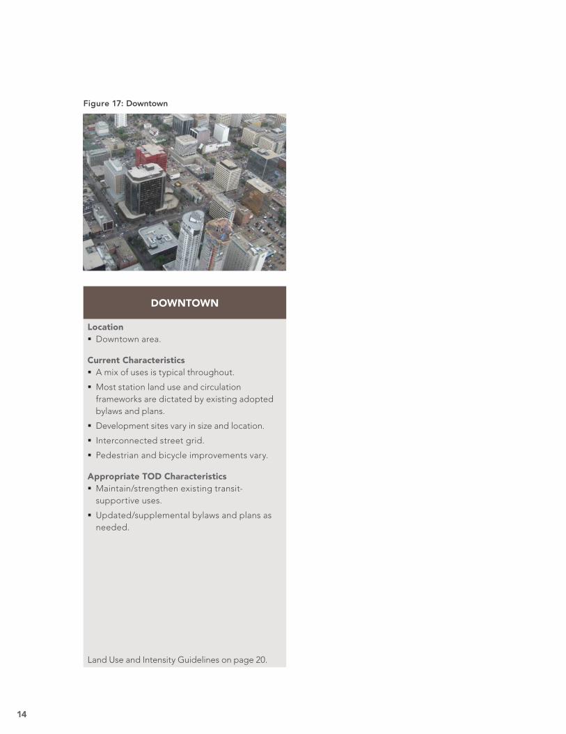
DOWNTOWN
Location Downtown area.
Current Characteristics A mix of uses is typical throughout.
Most station land use and circulation frameworks are dictated by existing adopted bylaws and plans.
Development sites vary in size and location.
Interconnected street grid.
Pedestrian and bicycle improvements vary.
Appropriate TOD Characteristics Maintain/strengthen existing transit-supportive uses.
Updated/supplemental bylaws and plans as needed.
Land Use and Intensity Guidelines on page 20.
Figure 17: Downtown
15
NEIGHBOURHOODLAND USE AND INTENSITY GUIDELINES
Sites within
400 metres
of the
LRT platform
or Transit
Centre
For sites 1.0 ha or larger: 125 du/ha min; or
For sites fronting or fl anking a collector road:
42 du/ha min to 125 du/ha max; or
For sites fronting or fl anking an arterial road:
63 du/ha min to 125 du/ha max; or
For all other sites: 42 du/ha max
Secondary or Garage or Garden suites are appropriate on selected sites.
Appropriate on arterial or collector roads, located above ground fl oor retail.
Appropriate on sites with direct access to an arterial or collector road, supported by curbside parking; orAppropriate on existing shopping centre sites of 2 or more ha. Auto oriented site design is not appropriate.Residential, retail or offi ce uses can be accommodated on upper fl oors.
Area of appli-
cation varies
depending
on the neigh-
bourhood
context and
can extend up
to 800 metres
from the LRT
platform or
Transit Centre
RESIDENTIAL EMPLOYMENT GROUND FLOOR RETAIL
EXPECTATIONS FOR ALL PLANS THAT INCLUDE AN LRT OR TRANSIT CENTRE STATION AREA
EXPECTATIONS FOR LRT AND TRANSIT CENTRE STATION AREASWITHOUT STATION AREA PLANS
RESIDENTIAL (NET) EMPLOYMENT GROUND FLOOR RETAIL
Densities are the same as expectations for stations without a Station Area Plan, but these may be increased to accommodate the unique context of the specifi c neighbourhood.
Appropriate on arterial or collector roads, located above ground fl oor retail.
Should occupy no more than 20% of all net developable area within 400 metres of the LRT platform or transit centre.
Recommended 500 to 2000 m2 cumulative building area within 200 metres of the LRT platform or transit centre.Appropriate on sites with direct access to an arterial or collector road, supported by curbside parking, or on existing shopping centre sites of 2 or more ha.Auto oriented site design is not appropriate.Residential, retail or offi ce uses can be accommodated on upper fl oors.
LAND USE AND INTENSITY GUIDELINES
The Neighbourhood Station Area Guidelines for LRT stations and transit centres ensure that incremental small-site development is of an appropriate scale and fit. These areas are typically comprised of single-family residential neighbourhoods. Arterial and collector roads and larger sites provide an opportunity for more transit supportive densities, and the guidelines allow for intensifi cation with
the provision that development is sympathetic to surrounding existing uses. The guidelines promote a mix of uses. Where opportunity sites meet fundamental real estate siting requirements for access and visibility, neighbourhood-serving retail uses are encouraged. These guidelines should be used in conjunction with the Land Use and Intensity Descriptions (page 21).
NEIGHBOURHOOD STATION AREAS
Figure 18: Neighbourhood–Land Use and Intensity Guidelines
16
NEW NEIGHBOURHOODLAND USE AND INTENSITY GUIDELINES
Sites within
200 metres
of the LRT
platform or
transit centre
For sites 0.25 ha or larger: 125 du/ha min; or
For all other sites: 63 du/ha min
Secondary or Garage or Garden suites are appropriate on selected sites.
Appropriate on sites with direct access to an arterial or collector road.
1.0 FAR min
Appropriate on sites with direct access to an arterial or collector road, supported by curbside parking.Auto oriented site design is not appropriate.Residential, retail or offi ce uses can be accommodated on upper fl oors.
EXPECTATIONS FOR LRT AND TRANSIT CENTRE STATION AREASWITHOUT STATION AREA PLANS
Sites within
200-400
metres of the
LRT platform
or transit
centre
For sites 0.25 ha or larger: 63 du/ha min; or
For all other sites: 42 du/ha min
Secondary or Garage or Garden suites are appropriate on selected sites.
Guidelines are the same as for sites within 200 metres of the LRT platform or transit centre.
Guidelines are the same as for sites within 200 metres of the LRT platform or transit centre.
Area of appli-
cation varies
depending
on the neigh-
bourhood
context and
can extend up
to 800 metres
from the LRT
platform or
transit centre
Densities are the same as expectations for stations without a Station Area Plan, but these may be increased to accommodate the unique context of the specifi c neighbourhood.
Appropriate on sites with direct access to an arterial or collector road.
Should occupy no more than 20% of all net developable land area within 400 metres of the LRT platform or transit centre
2.0 FAR min
RESIDENTIAL EMPLOYMENT GROUND FLOOR RETAIL
EXPECTATIONS FOR ALL PLANS THAT CONTAIN AN LRT OR TRANSIT CENTRE STATION AREA
Recommended 2000 to 14000 m2 cumulative building area within 400 metres of the LRT platform or transit centre.
Appropriate on sites with direct access to an arterial or collector road, supported by curbside parking.Auto oriented site design is not appropriate.Residential, retail or offi ce uses can be accommodated on upper fl oors.
RESIDENTIAL (NET) EMPLOYMENT GROUND FLOOR RETAIL
The New Neighbourhood Station Area Guidelines for LRT stations and transit centres ensure that new development is of a greater density/intensity. This will maximize development opportunities on large-scale sites. The guidelines promote a mix of station- and residential-supportive uses, and ensure development in these areas is of an appropriate scale and form for greenfi eld opportunities, and
infi ll opportunities when applicable.
Planning and zoning will ensure that the proposed developments are of high architectural quality with a mix that establishes housing as the predominant use with market supportable mixes of retail, commercial and employment.
NEW NEIGHBOURHOOD STATION AREAS
Figure 19: New Neighbourhood–Land Use and Intensity Guidelines
17
ENHANCED NEIGHBOURHOODLAND USE AND INTENSITY GUIDELINES
Sites within
200 metres
of the
platform
For sites fronting or fl anking an arterial or collector road, or on sites 0.25 ha or larger:
225 du/ha min; or
For all other sites: 125 du/ha min
Secondary or Garage or Garden suites are appropriate on selected sites.
Appropriate on sites with direct access to an arterial or collector road.
1.0 FAR min
Appropriate on sites with direct access to an arterial or collector road, supported by curbside parking.
Auto oriented site design is not appropriate.Residential, retail or offi ce uses can be accommodated on upper fl oors.
EXPECTATIONS FOR LRT STATION AREAS WITHOUT STATION AREA PLANS
Area of ap-
plication var-
ies depend-
ing on the
neighbour-
hood con-
text and can
extend up to
800 metres
from the LRT
platform
Densities are the same as expectations for stations without a Station Area Plan, but these may be increased to accommodate the unique context of the specifi c neighbourhood.
Appropriate on sites with direct access to an arterial or collector road.
Should occupy no more than 20% of all net developable area within 400 metres of the LRT platform.
2.0 FAR min
RESIDENTIAL EMPLOYMENT GROUND FLOOR RETAIL
EXPECTATIONS FOR ALL PLANS THAT CONTAIN AN LRT STATION AREA
Recommended 5000 to 20000 m2 cumulative building area within 400 metres of the LRT platform.Appropriate on sites with direct access to an arterial or collector road, supported by curbside parking or on existing shopping centre sites of 2 or more ha.Auto oriented site design is not appropriate.Residential, retail or offi ce uses can be accommodated on upper fl oors.
RESIDENTIAL (NET) EMPLOYMENT GROUND FLOOR RETAIL
Sites within
200-400
metres of
the platform
For sites 0.25 ha or larger: 225 du/ha min; or
For sites fronting or fl anking an arterial or collector road:
63 du/ha min to 125 du/ha max; or
For all other sites: 63 du/ha max
Secondary or Garage or Garden suites are appropriate on selected sites.
Guidelines are the same as for sites within 200 metres of the LRT platform.
Guidelines are the same as for sites within 200 metres of the LRT platform.
The Enhanced Neighbourhood Station Areas Guidelines allow a blend of appropriate station and residential supportive uses. They ensure development in these areas is of an appropriate scale and form for both large and smaller infi ll and greenfi eld opportunities.
Planning and zoning will ensure that the proposed developments are of high architectural quality with a mix that establishes housing as the predominant use with market supportable mixes of retail, commercial and employment.
ENHANCED NEIGHBOURHOOD STATION AREAS
Figure 20: Enhanced Neighbourhood–Land Use and Intensity Guidelines
18
CENTRELAND USE AND INTENSITY GUIDELINES
EXPECTATIONS FOR LRT STATION AREAS WITHOUT STATION AREA PLANS
EXPECTATIONS FOR ALL PLANS THAT CONTAIN AN LRT STATION AREA
Area of ap-
plication var-
ies depend-
ing on the
neighbour-
hood con-
text and can
extend up to
800 metres
from the LRT
platform
Densities are the same as expectations for stations without a Station Area Plan, but these may be increased to accommodate the unique context of the specifi c neighbourhood.
Appropriate on sites with direct access to an arterial or collector road.
Should occupy no more than 20% of all net developable area within 400 metres of the LRT platform.
2.0 FAR min
RESIDENTIAL EMPLOYMENT GROUND FLOOR RETAIL
Recommended 14000 to 46000 m2 cumulative building area within 200 metres of the LRT platform.
Auto oriented site design is not appropriate.Appropriate on existing shopping centre sites of 2 or more ha; or
Appropriate on sites with direct access to an arterial or collector road, supported by curbside parking. Residential, retail or offi ce uses can be accommodated on upper fl oors.
RESIDENTIAL (NET) EMPLOYMENT GROUND FLOOR RETAIL
Sites within
200 metres
of the
platform
For sites fronting or fl anking an arterial or collector road, or on sites 0.25 ha or larger:
225 du/ha min; or
For all other sites: 125 du/ha min
Secondary or Garage or Garden suites are appropriate on selected sites.
Appropriate on sites with direct access to an arterial or collector road.
1.0 FAR min
Appropriate on sites with direct access to an arterial or collector road, supported by curbside parking.Auto oriented site design is not appropriate.Residential, retail or offi ce uses can be accommodated on upper fl oors.
Sites within
200 - 400
metres of the
platform
For sites 0.25 ha or larger: 225 du/ha min; or
For sites fronting or fl anking an arterial or collector road:
63 du/ha min to 125 du/ha max; or
For all other sites: 63 du/ha max
Secondary or Garage or Garden suites are appropriate on selected sites.
Guidelines are the same as for sites within 200 metres of the LRT platform.
Guidelines are the same as for sites within 200 metres of the LRT platform.
The Centre Station Area Guidelines allow a blend of appropriate station and residential supportive uses. They ensure development in these areas is of an appropriate density, scale, and form for all development opportunity sites. The uses allowed in the Centre Station Areas will include retail, offi ce, commercial and higher density residential. Retail uses are expected to be the predominant use, with
a minor proportion of commercial and offi ce uses. New development will focus around a corridor serving street-oriented retail centre. Residential use is desirable around these new centre areas particularly as transitional elements when adjacent or in proximity to mature neighbourhoods.
CENTRE STATION AREAS
Figure 21: Centre–Land Use and Intensity Guidelines
19
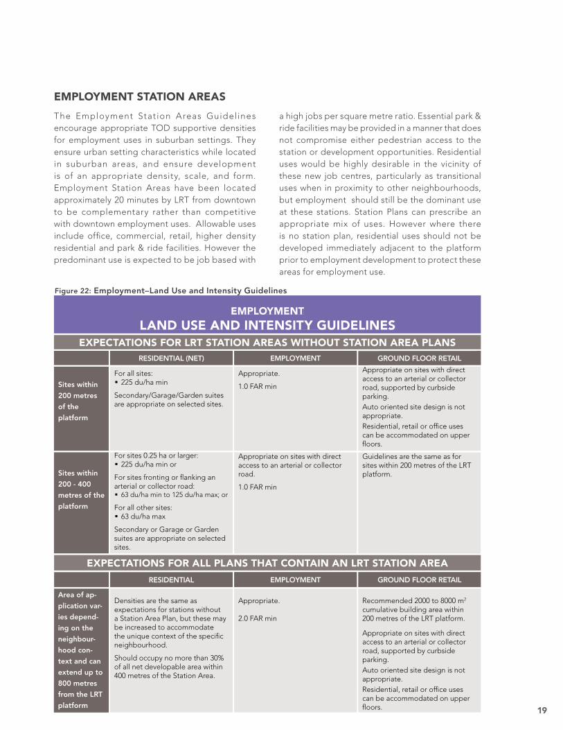
EMPLOYMENTLAND USE AND INTENSITY GUIDELINES
EXPECTATIONS FOR LRT STATION AREAS WITHOUT STATION AREA PLANS
Sites within
200 - 400
metres of the
platform
For sites 0.25 ha or larger: 225 du/ha min or
For sites fronting or fl anking an arterial or collector road:
63 du/ha min to 125 du/ha max; or
For all other sites: 63 du/ha max
Secondary or Garage or Garden suites are appropriate on selected sites.
Appropriate on sites with direct access to an arterial or collector road.
1.0 FAR min
Guidelines are the same as for sites within 200 metres of the LRT platform.
RESIDENTIAL EMPLOYMENT GROUND FLOOR RETAIL
EXPECTATIONS FOR ALL PLANS THAT CONTAIN AN LRT STATION AREA
Area of ap-
plication var-
ies depend-
ing on the
neighbour-
hood con-
text and can
extend up to
800 metres
from the LRT
platform
Densities are the same as expectations for stations without a Station Area Plan, but these may be increased to accommodate the unique context of the specifi c neighbourhood.
Should occupy no more than 30% of all net developable area within 400 metres of the Station Area.
Appropriate.
2.0 FAR min
Recommended 2000 to 8000 m2 cumulative building area within 200 metres of the LRT platform.
Appropriate on sites with direct access to an arterial or collector road, supported by curbside parking.Auto oriented site design is not appropriate.Residential, retail or offi ce uses can be accommodated on upper fl oors.
RESIDENTIAL (NET) EMPLOYMENT GROUND FLOOR RETAIL
Sites within
200 metres
of the
platform
For all sites: 225 du/ha min
Secondary/Garage/Garden suites are appropriate on selected sites.
Appropriate.
1.0 FAR min
Appropriate on sites with direct access to an arterial or collector road, supported by curbside parking.Auto oriented site design is not appropriate.Residential, retail or offi ce uses can be accommodated on upper fl oors.
The Employment Stat ion Areas Guidelines encourage appropriate TOD supportive densities for employment uses in suburban settings. They ensure urban setting characteristics while located in suburban areas, and ensure development is of an appropriate density, scale, and form. Employment Station Areas have been located approximately 20 minutes by LRT from downtown to be complementary rather than competitive with downtown employment uses. Allowable uses include offi ce, commercial, retail, higher density residential and park & ride facilities. However the predominant use is expected to be job based with
a high jobs per square metre ratio. Essential park & ride facilities may be provided in a manner that does not compromise either pedestrian access to the station or development opportunities. Residential uses would be highly desirable in the vicinity of these new job centres, particularly as transitional uses when in proximity to other neighbourhoods, but employment should still be the dominant use at these stations. Station Plans can prescribe an appropriate mix of uses. However where there is no station plan, residential uses should not be developed immediately adjacent to the platform prior to employment development to protect these areas for employment use.
EMPLOYMENT STATION AREAS
Figure 22: Employment–Land Use and Intensity Guidelines
20
As individual projects, Station Area Plans, master plans or other major re-zoning or planning efforts are undertaken for Institution/Recreation Areas, particular attention should be paid to the Urban Design Principles to ensure the highest quality and best urban form achievable is demanded of these intensely developed and transit-supportive areas.
All proposed development, including new infi ll development, should be compatible with the existing context. Should the new development be adjacent or proximate to mature neighbourhoods, this must be achieved through the following:
Use of quality and contextually-appropriate materials.
Compatible roof forms and façade composition.
Articulation of building masses and façades to defi ne scale.
Screening and/or landscaping of parking, mechanical, and other elements incompatible with the surrounding context.
Locating windows and entries to maximize privacy and minimize impacts for adjacent properties.
Providing on-site amenities (landscaped areas, open space) appropriate to the scale of the development to buffer older, adjacent residential areas.
INSTITUTION/RECREATIONGENERAL GUIDELINES
As individual projects, Station Area Plans, or other major rezoning or planning efforts are undertaken for Downtown areas, particular attention should be paid to the Urban Design Principles to ensure the highest quality and best urban form achievable is demanded of these intensely developed and transit-supportive areas.
All proposed development, including new infi ll development, should be compatible with the existing context. Should the new development be adjacent or proximate to mature neighbourhoods, this must be achieved through the following:
Use of quality and contextually-appropriate materials.
Compatible roof forms and façade composition.
Articulation of building masses and façades to defi ne scale.
Screening and/or landscaping of parking, mechanical, and other elements incompatible with the surrounding context.
Locating windows and entries to maximize privacy and minimize impacts for adjacent properties.
Providing on-site amenities (landscaped areas, open space) appropriate to the scale of the development to buffer older, adjacent residential areas.
DOWNTOWNGENERAL GUIDELINES
Each Institution/Recreation Station Area typically has its own unique needs. They often have specifi c existing applicable zoning regulations and uses and are usually defined by institutional master planning in anticipation of long-term institutional expansion. As such, detailed guidelines specifi c to Institutional Areas have not been proposed. Where no Institution/Recreation master plan exists, guidelines for the Neighbourhood Station Area Type will apply within 400 metres of the LRT station or transit station.
As Downtown Station Areas have highly specifi c and evolved existing applicable zoning regulations and plans, detailed guidelines specifi c to downtown have not been proposed.
The graphics on the following pages illustrate land use and intensity expectations identifi ed on the Land Use and Intensity Guideline tables. These descriptions should be used in conjunction with the guideline table.
63 DU/HA RESIDENTIALSTACKED ROW HOUSE
The above image illustrates typical building form, scale and massing only. Building character can vary and will be determined by site context.
LAND USE AND INTENSITY DESCRIPTIONS
42 DU/HA RESIDENTIALROW HOUSE
The above image illustrates typical building form, scale and massing only. Building character can vary and will be determined by site context.
Figure 26: 63 DU/HA (Dwelling Units per Hectare)Figure 25: 42 DU/HA (Dwelling Units per Hectare)
22
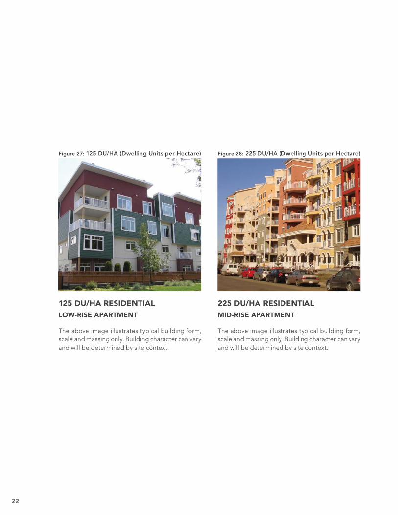
125 DU/HA RESIDENTIALLOW-RISE APARTMENT
The above image illustrates typical building form, scale and massing only. Building character can vary and will be determined by site context.
Figure 27: 125 DU/HA (Dwelling Units per Hectare)
225 DU/HA RESIDENTIALMID-RISE APARTMENT
The above image illustrates typical building form, scale and massing only. Building character can vary and will be determined by site context.
Figure 28: 225 DU/HA (Dwelling Units per Hectare)
23
0.5 F.A.R. EMPLOYMENT
The above graphic illustrates an example of 0.5 F.A.R.
The above image illustrates typical building form, scale and massing only. Building character can vary and will be determined by site context.
Figure 29: 0.5 F.A.R. (Floor Area Ratio)
24
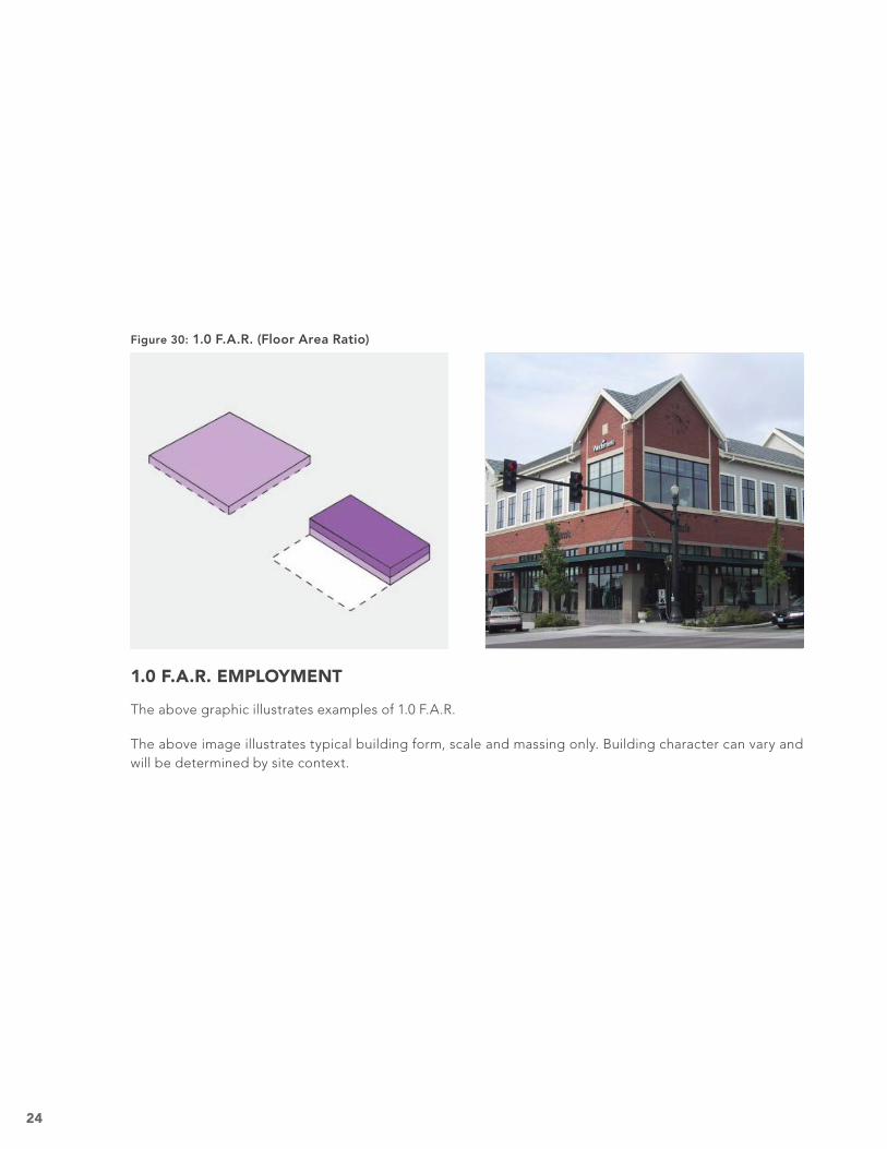
1.0 F.A.R. EMPLOYMENT
The above graphic illustrates examples of 1.0 F.A.R.
The above image illustrates typical building form, scale and massing only. Building character can vary and will be determined by site context.
Figure 30: 1.0 F.A.R. (Floor Area Ratio)
25
2.0 F.A.R. EMPLOYMENT
The above graphic illustrates examples of 2.0 F.A.R.
The above image llustrates typical building form, scale and massing only. Building character can vary and will be determined by site context.
Figure 31: 2.0 F.A.R. (Floor Area Ratio)
26
BUILDING AND SITE DESIGN GUIDELINES
The guidelines ensure that buildings activate and engage the public realm to contribute to a safe and active street environment. The character of new development should be compatible with surrounding existing uses. Opportunity exists to build upon the area’s character or develop unique localities.
For residential uses, private and common amenity areas should be provided that are appropriate to the scale of development. Generally, all units should have some private amenity area. Apartment developments should include an indoor or outdoor common amenity space for use by the residents of the development. In the case of larger developments, a combination of indoor and outdoor common amenity should be provided.
Apartment developments should incorporate family suitable housing, particularly at the ground level where there is a private exterior unit entry and opportunity for a private at-grade amenity area. Apartment development, retail and employment uses should accommodate bicycle parking on site.
Parking requirements in LRT station areas and transit centres should be lower than outside of these areas. The separation of parking for residential land use and shared parking for non-residential land uses should be considered also in these areas.
The tables and diagrams on the following pages describe building and site design elements. These guidelines may be initiated by the City of Edmonton.
27
Building and Site Design Descriptions are on pages 28 to 33.
Figure 32: Building and Site Design Guidelines
ALL STATION AREA TYPESBUILDING AND SITE DESIGN GUIDELINES
Transition
Development of 4 storeys in height: On sites abutting a single detached, semi detached, or row housing zone, the height of the abutting facade should be stepped down to the maximum height permitted in the adjacent zone so that there is a transitioning of height between the two developments to be more compatible in mass and scale.
Development of 5 to 6 storeys in height: On sites abutting a single detached, semi detached, or row housing zone, the height of the abutting facade should be stepped down to the maximum height permitted in the adjacent zone, and additional step backs should be incorporated into the building so that the bulk of the building is located away from the shared property line.
Development over 6 storeys in height should only be located where a Station Area Plan has been prepared to accommodate transitions or on a large site of 1 or more hectares so that appropriate transitions can be accommodated on site.
Building
Design
Use of sympathetic, quality, contextually appropriate material.
Use of compatible roof forms and façade composition.
Articulation of building masses and façade to defi ne scale.
Use of landscaping to screen parking, mechanical, and garbage areas.
Location of windows and entries to maximize privacy for adjacent properties.
ALL USES
CIVIC/CULTURAL/EMPLOYMENT USES RETAIL USES
0 metres max. for ground-fl oor uses.
3 metres max. for ground-fl oor uses.
RESIDENTIAL USES
Building Setback from Street
3 metres max. for ground-fl oor uses.
Ground level uses fronting a street to provide a primary street-facing lobby entry.
Ground level to provide a primary street-facing entry.
Entries
Ground level units fronting a street to provide a primary street-facing entry.
Ground level units fronting accessway or courtyard to provide a primary exterior entry.
Transparency 50% transparency at street level. 70% transparency at street level. 70% transparency at street level.
Site
Design
All buidings should front onto a street.
Parking for low, mid and high rise apartments, and commerical offi ce buildings should be located primarily underground.
Surface parking should be located away from the street and designed in smaller clusters, separated by landscaped areas.
Retail and commercial buildings should be designed to create the appearance of small (10 m) regularly spaced frontages along the street.
28
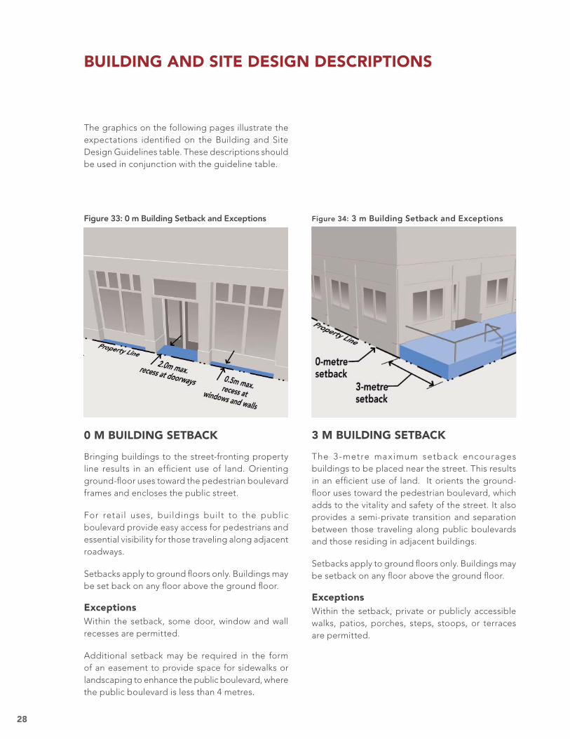
0 M BUILDING SETBACK
Bringing buildings to the street-fronting property line results in an effi cient use of land. Orienting ground-fl oor uses toward the pedestrian boulevard frames and encloses the public street.
For retail uses, buildings built to the public boulevard provide easy access for pedestrians and essential visibility for those traveling along adjacent roadways.
Setbacks apply to ground fl oors only. Buildings may be set back on any fl oor above the ground fl oor.
ExceptionsWithin the setback, some door, window and wall recesses are permitted.
Additional setback may be required in the form of an easement to provide space for sidewalks or landscaping to enhance the public boulevard, where the public boulevard is less than 4 metres.
3 M BUILDING SETBACK
The 3-metre maximum setback encourages buildings to be placed near the street. This results in an effi cient use of land. It orients the ground-fl oor uses toward the pedestrian boulevard, which adds to the vitality and safety of the street. It also provides a semi-private transition and separation between those traveling along public boulevards and those residing in adjacent buildings.
Setbacks apply to ground fl oors only. Buildings may be setback on any fl oor above the ground fl oor.
ExceptionsWithin the setback, private or publicly accessible walks, patios, porches, steps, stoops, or terraces are permitted.
The graphics on the following pages illustrate the expectations identifi ed on the Building and Site Design Guidelines table. These descriptions should be used in conjunction with the guideline table.
BUILDING AND SITE DESIGN DESCRIPTIONS
Figure 33: 0 m Building Setback and Exceptions Figure 34: 3 m Building Setback and Exceptions
29
Figure 36: Residential Courtyard Entries
RESIDENTIAL ENTRIES
Ground-fl oor individual dwelling units and main lobby entries should be oriented to the street or to a street-facing courtyard to contribute to the vitality and safety of station areas through ‘eyes on the street’ surveillance.
By locating entries facing the street, residents and visitors will enter and exit the building from the public boulevard, thereby activating and animating the public realm.
Figure 35: Residential Street Entries
30
EMPLOYMENT ENTRIES
Entries to main lobbies of ground-fl oor employment uses should be oriented to the street to allow direct access from the public boulevard, promoting activity on public streets.
Figure 38: Employment Lobby Entries
RETAIL ENTRIES
Individual retail shop entries should be oriented to the street to contribute to the vitality and safety of station areas through ‘eyes on the street’ surveillance and the use of pedestrian boulevards to access these uses.
Primary business entries should face the street; Secondary entries are permitted along all other frontages.
Retail entries should have at-grade entries fronting public boulevards; ramps or steps are prohibited.
All doorway glazing should be transparent; tinted, refl ective or other opaque materials or treatments shall be prohibited.
Figure 37: Retail Entries
31
50% LINEAR TRANSPARENCY
A moderate degree of visibility through windows and/or doors is appropriate for all residential uses located at the ground fl oor.
The percent of transparency is measured at 1.5 metres above the building’s fi rst fi nished-fl oor height to account for raised stoops or terraces, which provide privacy, and a transition and separation from the public boulevard.
Linear transparency measurement encompasses the entire building frontage.
Figure 39: 50% Transparency -Residential
32
70% LINEAR TRANSPARENCY
A high degree of visibility through building windows and/or doors can support safe and active streets by creating a visual connection between pedestrians and building users. This level of transparency is appropriate for all retail and employment uses located at the ground fl oor. The opening:
Is measured as linear metres of total building frontage.
Should be measured 1.5 metres above the fi nished grade of the adjacent public boulevard to promote optimum visibility for passers-by.
Should be entirely transparent with the exception of applied window signs that shall be no larger than 10% of any single opening.
Should not include tinted, refl ective or other opaque materials or treatments.
Figure 40: 70% Transparency -Retail and Employment
33
Figure 41: Transitions
TRANSITION
Single-Family 4 StoreyRow Housing Buildings
TRANSITION
Single-Family 5-6 StoreyRow Housing Buildings
As redevelopment occurs around station areas, there will be some instances where low- and mid-rise apartments develop adjacent to existing smaller scale row housing, duplex and single-family homes. New apartment developments should be designed to create a gradual transition in height, to address both the visual appearance from the street and the potential impacts of shadow and loss of privacy for the smaller scale existing development.
34
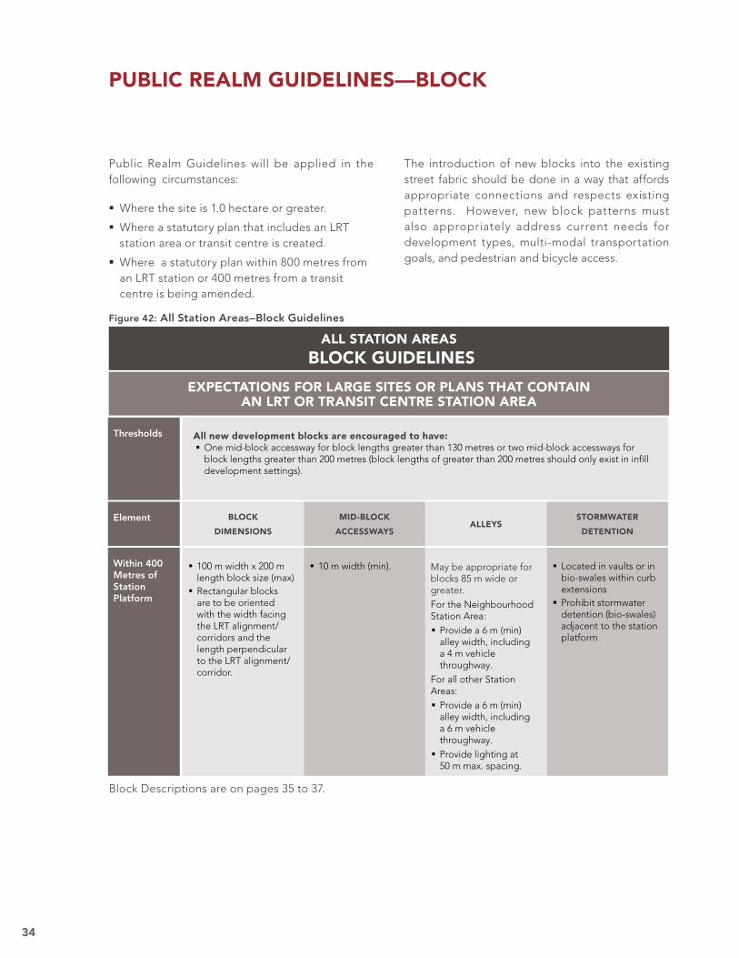
ALL STATION AREAS BLOCK GUIDELINES
Thresholds All new development blocks are encouraged to have: One mid-block accessway for block lengths greater than 130 metres or two mid-block accessways for block lengths greater than 200 metres (block lengths of greater than 200 metres should only exist in infi ll development settings).
BLOCK
DIMENSIONS
MID-BLOCK
ACCESSWAYSALLEYS
STORMWATER
DETENTION
Element
Within 400 Metres of Station Platform
Located in vaults or in bio-swales within curb extensions
Prohibit stormwater detention (bio-swales) adjacent to the station platform
May be appropriate for blocks 85 m wide or greater.For the Neighbourhood Station Area:
Provide a 6 m (min) alley width, including a 4 m vehicle throughway.
For all other Station Areas:
Provide a 6 m (min) alley width, including a 6 m vehicle throughway.
Provide lighting at 50 m max. spacing.
10 m width (min). 100 m width x 200 m length block size (max)
Rectangular blocks are to be oriented with the width facing the LRT alignment/corridors and the length perpendicular to the LRT alignment/corridor.
EXPECTATIONS FOR LARGE SITES OR PLANS THAT CONTAIN AN LRT OR TRANSIT CENTRE STATION AREA
PUBLIC REALM GUIDELINES—BLOCK
Public Realm Guidelines will be applied in the following circumstances:
Where the site is 1.0 hectare or greater.
Where a statutory plan that includes an LRT station area or transit centre is created.
Where a statutory plan within 800 metres from an LRT station or 400 metres from a transit centre is being amended.
The introduction of new blocks into the existing street fabric should be done in a way that affords appropriate connections and respects existing patterns. However, new block patterns must also appropriately address current needs for development types, multi-modal transportation goals, and pedestrian and bicycle access.
Block dimensions, and the street grid they form, are among the most critical elements in ensuring a walkable and bikeable community. The connectivity established by smaller block dimensions and a greater number of multi-modal linkages will support transit ridership by providing more access routes to the station and disperse vehicle traffi c to create livable communities.
Figure 44: Maximum Block SizeFigure 43: Typical Edmonton Block
EDMONTON’S BLOCKS
Edmonton’s street grid consists of numerous block sizes and patterns, refl ective of the time period and topography in which they were built. Like many other cities, a block size was defi ned for downtown and residential patterns at the City’s inception. As the City developed, the initial pattern was typically duplicated, though different eras and conditions led to some variety in block sizes.
Most blocks are rectangular—the shorter side representing the width and the longer side representing the length—and the blocks are roughly twice as long as they are wide. Block sizes vary from 75 to 100 metres in width and up to 250 metres in length. Most residential blocks have a mid-block service alley running the block length.
BLOCK DESCRIPTIONS
The graphics on the following pages illustrate the expectations identifi ed on the Block Guidelines table. These descriptions should be used in conjunction with the guideline table.
36
MID-BLOCK ACCESS WAYS
Mid-block access ways should be publicly accessible 24-hours a day. This can be accomplished through public ownership or public easement.
Figure 45: Mid-Block Accessway Example
MID-BLOCK ACCESSWAYS
For redevelopment and new development, mid-block accessways are encouraged to break up blocks of 130 metres or more in length and:
Result in development sites with more pedestrian and bicycle connections, visual permeability, and pedestrian-scaled building footprints.
Provide attractive linear amenities that serve as passive recreation spaces for adjacent housing, retail and employment uses.
May include limited vehicle access for vehicle loading, drop-off and deliveries, and on-site private parking facilities.
Figure 46: Mid-Block Accessway
37
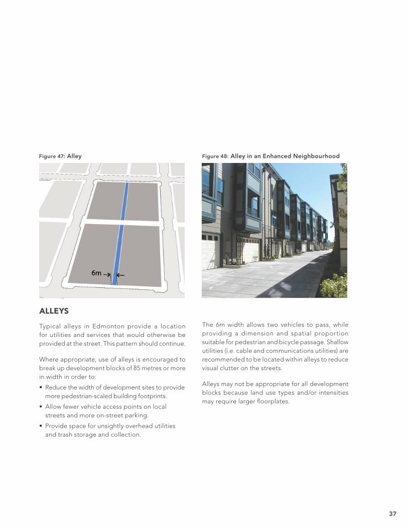
The 6m width allows two vehicles to pass, while providing a dimension and spatial proportion suitable for pedestrian and bicycle passage. Shallow utilities (i.e. cable and communications utilities) are recommended to be located within alleys to reduce visual clutter on the streets.
Alleys may not be appropriate for all development blocks because land use types and/or intensities may require larger fl oorplates.
Figure 48: Alley in an Enhanced Neighbourhood
ALLEYS
Typical alleys in Edmonton provide a location for utilities and services that would otherwise be provided at the street. This pattern should continue.
Where appropriate, use of alleys is encouraged to break up development blocks of 85 metres or more in width in order to:
Reduce the width of development sites to provide more pedestrian-scaled building footprints.
Allow fewer vehicle access points on local streets and more on-street parking.
Provide space for unsightly overhead utilities and trash storage and collection.
Figure 47: Alley
38
Thresholds Public boulevard improvements are encouraged for development sites that extend from: Block corner to block corner. Alley to block corner. Mid-block accessway to block corner. Mid-block accessway to mid-block accessway.
ALL STATION AREAS PUBLIC BOULEVARD GUIDELINES
UniformExpectations
All new public streets should have public boulevards on both sides of the street that: Are not less than 4 metres wide (minimum). Are universally accessible. Include the boulevard elements described below.
All new development with a 0-metre setback should include overhead weather protection (i.e. awnings) that extends over the public boulevard and meets the following:
Projection–1.5 m minimum on front building façade. Internal illumination of the awning should be discouraged. Fascia signs–25 cm maximum.
Locate below grade with the exception of overhead LRT- related utilities.
PEDESTRIAN
THROUGHWAY
FURNITURE
ZONE
LIGHTING STREET
TREES
UTILITIESElements
For all block faces: Space trees 8 m apart (max) along block face.
Locate trees in furniture zone within tree wells, grates or planters.
For streets adjacent to the station:
Provide canopy-forming street tree varieties.
Pedestrian-scaled lighting should be provided within the station area.
Locate light standard in furniture zone.
1.5 m width (min). Paved or landscaped
2 m (min) width. Limit vehicle accesses to 2 per block face.
For streets adjacent to ground-fl oor retail:
Prohibit driveways or vehicle access (except for access to alleys).
Figure 49: All Station Areas–Public Boulevard Guidelines
EXPECTATIONS FOR LARGE SITES OR PLANS THAT CONTAIN AN LRT OR TRANSIT CENTRE STATION AREA
Properly designed public boulevards contribute to the quality and safety of the pedestrian environment. The Public Boulevards Guidelines defi ne essential elements to best serve these objectives. Adequate dimensioning offers an appropriate space for passage and shopping. Well-scaled furnishing zones separate pedestrians and cars, and allow
for the placement of trees, streetlights, benches, landscaping, and other street serving elements. Undergrounding utilities where possible minimizes visual clutter and maintenance. Overhead weather protection creates gathering and viewing places while providing year-round protection from the elements.
PUBLIC REALM GUIDELINES—PUBLIC BOULEVARD
Public Boulevard Descriptions are on pages 39 to 41.
39
PUBLIC BOULEVARD
To enhance pedestr ian safety and comfor t and encourage walking as a viable means of transpor tation in station areas, all new and renovated public boulevards should:
Consist of unobstructed pedestrian throughway, furniture and curb zones.
Meet the minimum dimensions for each zone.
Be universally accessible.
Consist of well-defi ned and quality-fi nished materials.
Adjacent to the station platform, non-LRT serving utilities should be located underground. Whenever possible, utilities should be located underground throughout the station area to prevent visual and physical clutter.
PUBLIC BOULEVARD DESCRIPTIONS
The graphics on the following pages illustrate the expectations identifi ed on the Public Boulevard Guidelines table. These descriptions should be used in conjunction with the guideline table.
Figure 50: Public Boulevard
40
OVERHEAD WEATHER PROTECTION
Sloped awnings and horizontal canopies provide rain and snow protection along building frontages. They support the attractiveness and success of retail when placed in those active storefront locations.
Figure 51: Overhead Weather Protection Example
41
STREET TREES
Appropriate tree species, spaced at 8 metres, enhance the quality of a station area‘s public boulevards. Street trees can:
Provide a visual softening to the built environment.
Buffer pedestrians from the auto environment.
Minimize summer heat gain.
Street trees should be located within the furniture zone on public boulevards.
Street trees should be planted and maintained in accordance with existing City of Edmonton requirements. Street tree selection should conform to the City’s approved street tree list.
STREET LIGHTING
To contribute to the safety, quality, and vitality of a station area, the spacing, height and lumens of street lights should be considered. This is intended to:
Ensure pedestrian-scaled lighting of sidewalks and crosswalks.
Illuminate the public boulevard.
Prevent auto-oriented street lighting.
Light standards should be located within the furniture zone on public boulevards.
‘Dark sky’ lighting should be considered. However, lighting can provide a sparkle, festive and even magical street ambiance, especially within retail districts. In no instance should this potential be compromised.
Figure 52: Street Trees Figure 53: Street Lighting Example
42
ALL STATION AREAS URBAN PARK AND PLAZA GUIDELINES
Urban Plazas 0.25 ha (min) area
0.5 ha (max) area
When provided may include: Public art. 75% paved (min). 1 public restroom (min). 40 benches (min) or equivalent fi xed/movable seating. 90 m2 (min)/ 230 m2 (max) retail pavilion if no other active edges are present. Public streets, alley or midblock access way, on 3 sides.
Urban Parks 0.5 ha area (min)
1.0 ha area (max)
When provided may include: Public art. 50% turf (min). 1 public restroom (min). 10 benches or equivalent wall seating (min). 90 m2 covered area/pavilion (min). Public streets, alley or midblock access way, on 3 sides.
EXPECTATIONS FOR LARGE SITES OR PLANS THAT CONTAIN AN LRT OR TRANSIT CENTRE STATION AREA
Thresholds in One of the Following Situations
Urban parks are encouraged on sites within 400 metres of the station platform: In stations plans where there are no existing parks within 400 m of the station; or On large redevelopment sites with area greater than 6 net hectares (excluding streets) or greater than 9 gross hectares (including streets) where multi-family housing is proposed and where 20% or more of the site area is within 400 metres of the station platform.
Urban plazas are encouraged on sites within 200 metres of the station platform: In station plans for Enhanced Neighbourhood, Centre, and Downtown station types where there are no existing plazas within 200 m of the station; or
On large redevelopment sites with area greater than 6 net hectares (excluding streets) or greater than 9 gross hectares (including streets) and where 20% or more of the site area is within 200 metres of the station platform.
Major development projects provide an opportunity and responsibility to incorporate urban parks and urban plazas. Parks and plazas serve as amenities for people of all ages, during all seasons and during all hours of the day. The Urban Park and
Plaza Guidelines ensure that such spaces are properly scaled and incorporate the necessary amenities to best contribute to the safety, health, recreation, and economic vitality of the surrounding neighbourhoods.
PUBLIC REALM GUIDELINES—URBAN PARK AND PLAZA
Urban Park and Plaza Descriptions are on page 43.
Figure 54: All Station Areas–Urban Park and Plaza Guidelines
43
URBAN PARK
Urban parks are intended to be primarily neighbourhood serving.
Urban parks are intended to be the focus of adjacent surrounding development; adjacent buildings should be oriented toward the park.
Parks may be either active or passive.
View lines from adjacent public streets into and through the park should be maintained to ensure park safety.
Parks may front or adjoin natural areas or open space.
Multiple park blocks may be aligned to create promenades or other green corridors.
URBAN PLAZA
Urban plazas are intended to be transit corridor serving.
Urban plazas shall be allowed only when adjacent parcels have active ground-fl oor retail or public/civic uses.
View lines from adjacent public streets into and through the plaza should be maintained to ensure park safety.
Urban plazas should be designed for multiple use. Permanent and raised stages, amphitheatres, seating or other uses that limit fl exibility are not recommended.
The graphics on the following pages illustrate the expectations identifi ed on the Urban Park and Plaza Guidelines table. These descriptions should be used in conjunction with the guideline table.
URBAN PARK AND PLAZA DESCRIPTIONS
Figure 55: Urban Park Figure 56: Urban Plaza
44
Thresholds Bicycle facilities are encouraged on roadways that connect directly to the station area.
Bicycle facilities should be continuous within the broader bicycle transportation network.
Bicycle facilities should be suited to the context of the roadway.
Specifi c attention should be paid to the continuity of facility type within a broader context.
All new construction or major renovation of public streets must include bicycle parking (consistent with the Zoning Bylaw and Bicycle Transportation Plan).
ALL STATION AREAS BICYCLE FACILITY GUIDELINES
UniformExpectations
All major streets leading directly into the station should have a type of bicycle accommodation, and should connect into surrounding bike routes and major destinations.
Routes and wayfi nding signage should also lead to secure end-of-trip facilities.
SHARED-USE
PATHWAY
SEPARATED BICYCLE
LANESBICYCLE LANES SHARED LANES
SELECTED
INTERSECTION
IMPROVEMENTS
Elements
Bicycle boxes, bike signals, pavement markings, etc.
May be considered where volumes and intersection characteristics warrant. Used in conjunction with major bicycle routes and applied in accordance with TAC guidelines
Both directions on roadway
Single fi le or side-by-side applications
Application and associated signage in accordance with TAC guidelines
Both sides of the roadway
Application and associated signage in accordance with TAC guidelines
Physically separated bicycle lanes (either along one side of the roadway, or on both sides of the roadway)
Application in accordance with best practices.
Consideration must be given to minimizing intersection confl icts, and continuity of facility type within a broader context
One side of the roadway
Require minimal intersection crossings and confl icts with accesses
Application and associated signage in accordance with TAC guidelines
EXPECTATIONS FOR LARGE SITES OR PLANS THAT CONTAIN AN LRT OR TRANSIT CENTRE STATION AREA
BICYCLE FACILITIES GUIDELINES
A complete system of appropriately sized and placed bicycle elements is key to increasing the number and safety of bike riders. Bike routes should be developed in a manner that is sensitive to the area type and roadway type. They should be consistent with connecting bikeway types, and in consideration of the broader bicycle transportation network. Specifi c bikeway types that will be typical of TOD areas are shared-use paths, separated bicycle lanes, bicycle lanes and shared lanes.
PUBLIC REALM GUIDELINES —BICYCLE FACILITIES
The development of any bicycle facility should be in accordance with the Bicycle Transportation Plan, and appropriate Transportation Association of Canada (TAC) guidelines. Bicycle Parking requirements should be in accordance with the Zoning Bylaw.
Bicycle Facility Descriptions are on pages 45 to 48.
Figure 57: All Station Areas -Bicycle Facilities Guidelines
45
BICYCLE FACILITY (ON-STREET) DESCRIPTIONS
BICYCLE LANES
Bicycle lanes act as a guide to delineate areas on roadways appropriate for motorists and for cyclists. Bicycle lanes should be between 1.5 m and 2.0 m wide, marked on both sides of the roadway and located adjacent to the curb or parallel to street parking.
SHARED LANES
Shared lanes are shared by motorists and cyclists, marked with sharrows, within the same travel lane either in a single fi le or side-by-side. Single fi le shared lanes are appropriate on roadways with a speed limit of 50 km/h or less. Side-by-side shared lanes are appropriate for a greater range of speed limits but are only appropriate for travel lanes between 4.1 m and 4.9 m wide.
The graphics on the following pages illustrate the expectations identifi ed on the Bicycle Facility Guidelines table. These descriptions should be used in conjunction with the guideline table.
Figure 58: Bicycle Lanes Figure 59: Single-File Shared Lane
46
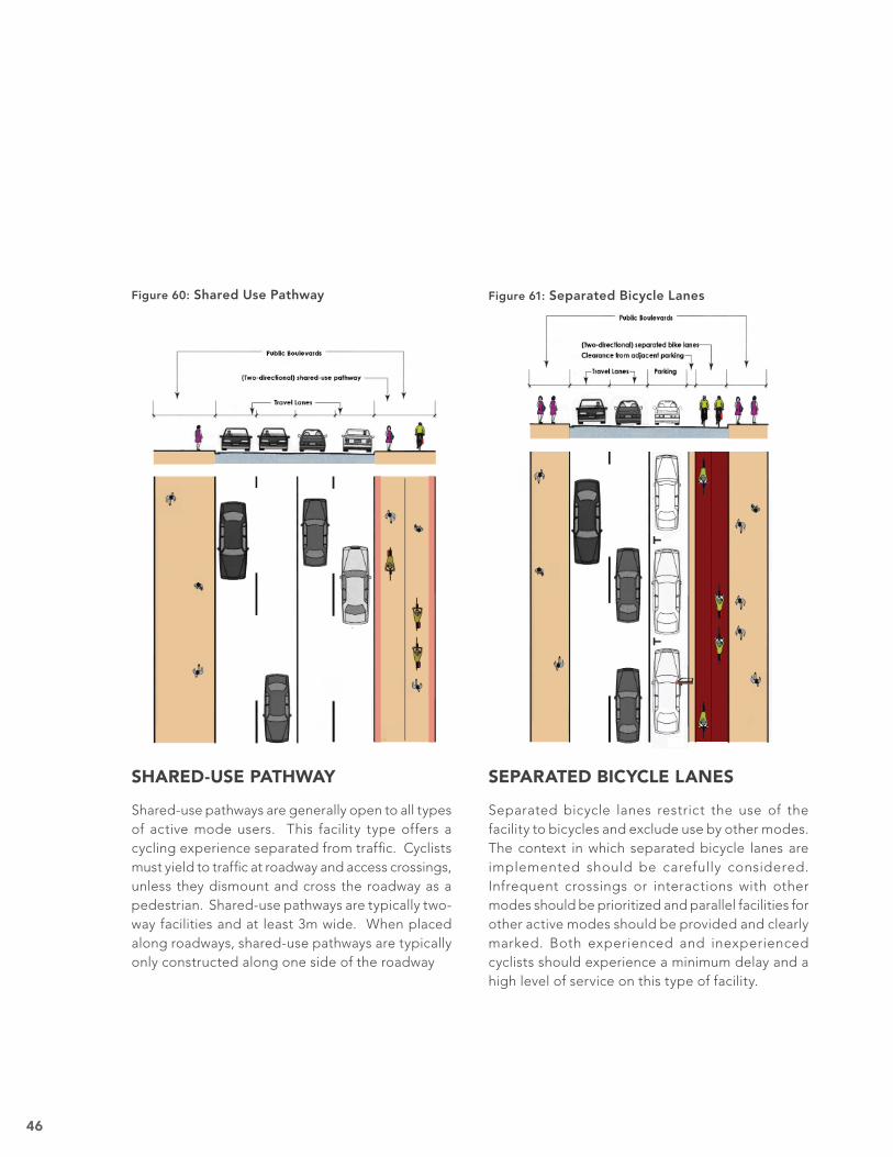
SHARED-USE PATHWAY
Shared-use pathways are generally open to all types of active mode users. This facility type offers a cycling experience separated from traffi c. Cyclists must yield to traffi c at roadway and access crossings, unless they dismount and cross the roadway as a pedestrian. Shared-use pathways are typically two-way facilities and at least 3m wide. When placed along roadways, shared-use pathways are typically only constructed along one side of the roadway
SEPARATED BICYCLE LANES
Separated bicycle lanes restrict the use of the facility to bicycles and exclude use by other modes. The context in which separated bicycle lanes are implemented should be carefully considered. Infrequent crossings or interactions with other modes should be prioritized and parallel facilities for other active modes should be provided and clearly marked. Both experienced and inexperienced cyclists should experience a minimum delay and a high level of service on this type of facility.
Figure 60: Shared Use Pathway Figure 61: Separated Bicycle Lanes
47
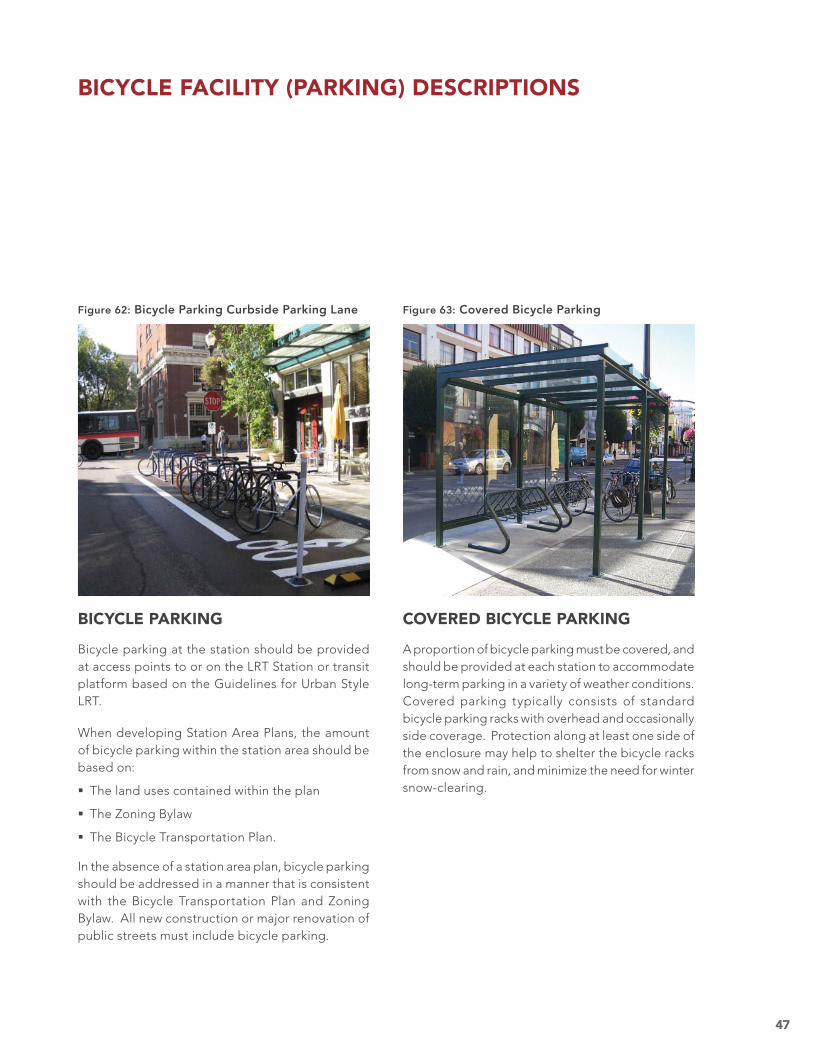
COVERED BICYCLE PARKING
A proportion of bicycle parking must be covered, and should be provided at each station to accommodate long-term parking in a variety of weather conditions. Covered parking typically consists of standard bicycle parking racks with overhead and occasionally side coverage. Protection along at least one side of the enclosure may help to shelter the bicycle racks from snow and rain, and minimize the need for winter snow-clearing.
BICYCLE PARKING
Bicycle parking at the station should be provided at access points to or on the LRT Station or transit platform based on the Guidelines for Urban Style LRT.
When developing Station Area Plans, the amount of bicycle parking within the station area should be based on:
The land uses contained within the plan
The Zoning Bylaw
The Bicycle Transportation Plan.
In the absence of a station area plan, bicycle parking should be addressed in a manner that is consistent with the Bicycle Transportation Plan and Zoning Bylaw. All new construction or major renovation of public streets must include bicycle parking.
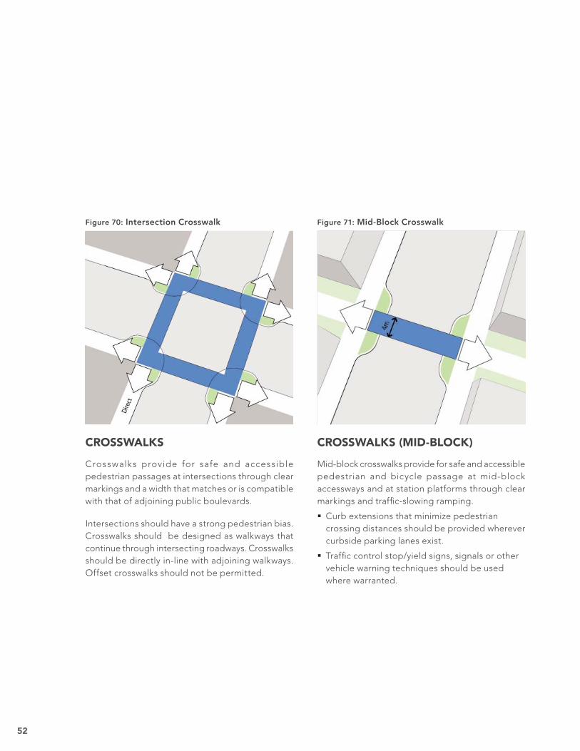
Bicycle parking can occur in one of the following three areas:
Curb extensions–attention must be paid to the precise placement of the bicycle racks to keep the corner clear for pedestrian movements and auto sight lines.
Parking lane–bicycle racks may be provided in lieu of vehicular parking, but should be protected by bollards and well-signed.
Furniture zone–bicycle racks should be placed to ensure that bicyclists do not impede pedestrian passage, and be placed with consideration of adjacent furniture and vehicle access where curbside parking is provided.
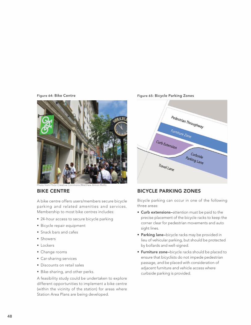
BIKE CENTRE
A bike centre offers users/members secure bicycle parking and related amenities and services. Membership to most bike centres includes:
24-hour access to secure bicycle parking
Bicycle repair equipment
Snack bars and cafes
Showers
Lockers
Change rooms
Car-sharing services
Discounts on retail sales
Bike-sharing, and other perks.
A feasibility study could be undertaken to explore different opportunities to implement a bike centre (within the vicinity of the station) for areas where Station Area Plans are being developed.
Photo from Flickr Creative Commons (Matthew Almon Roth).
Figure 65: Bicycle Parking ZonesFigure 64: Bike Centre
49
Thresh-olds
All public streets, where a minimum of one block of street length is under construction or major renovation, should include: Curbside vehicle parking Curb Extensions Crosswalks
LRT
TRACKWAY
TREATMENT
CURBSIDE
PARKING
CURB-
EXTENSIONS
(BUS STOPS)
CROSSWALKS
(MID-BLOCK)
CROSSWALKSCURB-
EXTENSIONS
RoadElements
Prohibit tie-ballast trackway
Provide high-quality paved/embed-ded trackway
Locate on both sides of the street:
2.5 m (min) parking lane width
Where retail is adjacent:
Limit hours for loading zones from 8pm-7am
Locate at all bus stops:
2.5 m x 15 m (min)
100% paved surface area
Provide weather-protected bus shelters and benches
Provide between all mid-block accessways
4 m wide marked walkway (min)
Provide from both ends of the station platform
Provide at each intersection:
4 m width (min) to match adjoining sidewalk width
Locate at all intersections:
2.5 m x 6 m (min)
50% (min) landscaped surface area
Prohibit Stormwater Detention (Bio-swales) on streets with retail frontages and adjacent to the station platform
Within 400 Me-tres of Station Platform
ALL STATION AREAS ROADWAY GUIDELINES
EXPECTATIONS FOR LARGE SITES OR PLANS THAT CONTAIN AN LRT OR TRANSIT CENTRE STATION AREA
TRANSIT
INTERCHANGE
KISS
AND RIDE
Drop-off of passengers from personal vehicles or taxis should be accomm-odated without detracting from pedestrian-oriented, develop-ment adjacent to the LRT station or transit centre
Refer to the Guidelines for Urban Style LRT.
Transfer of passengers between buses and LRT should be designed to be convenient and direct without detracting from pedestrian-oriented, develop-ment adjacent to the LRT station or transit centre
Refer to the Guidelines for Urban Style LRT.
Major development will result in the opportunity to establish high quality and TOD supportive streets. The Roadway Guidelines ensure that such streets will contribute to pedestrians’ safety and comfort with weather and traffi c protections. Curbside parking
contributes to safety by buffering pedestrians from traffi c while enhancing the vitality of adjacent retail and commercial activities.
PUBLIC REALM GUIDELINES—ROADWAY
Roadway Descriptions are on pages 51 to 52.
Figure 66: All Station Areas–Roadway Guidelines
50
ROADWAY PHILOSOPHY
Major private development /redevelopment projects provide opportunities to bring streets up to a higher level of quality, sustainability, safety and functionality. Such improvements contribute to the success of both public and private elements. The guidelines do so by:
Providing parking necessary to support commercial activity and separate moving vehicles and pedestrians.
Including curb extensions and intersection and mid-block crossings which reduce pedestrian road-crossing distances and times.
Encouraging a more visually integrated trackway.
Appropriately balancing hardscape and landscape treatments.
Figure 67: Roadway Example
51
CURB EXTENSIONS (TYPICAL)
Curb extensions protect pedestrians by minimizing roadway crossing distances and serving as a refuge for those waiting to cross streets. They also serve to slow traffi c and provide opportunities for streetscape enhancements such as landscaping, bike parking, seating and other street elements.
Corner radii should be minimized to reduce speeds of turning vehicles.
CURB EXTENSIONS (BUS STOPS)
Curb extensions provide in-traffi c bus stop locations that will accommodate all ETS bus vehicles. Curb extensions also protect bus riders by providing adequate queuing and exiting areas and affording suffi cient space for shelters. Where possible, bus stops should be located to accommodate curbside parking that supports retail uses adjacent to the station.
For more information about bus-to-LRT interchanges, refer to the Guidelines for Urban Style LRT.
ROADWAY DESCRIPTIONS
The graphics on the following pages illustrate the expectations identifi ed on the Roadway Guidelines table. These descriptions should be used in conjunction with the guideline table.
Crosswalks provide for safe and accessible pedestrian passages at intersections through clear markings and a width that matches or is compatible with that of adjoining public boulevards.
Intersections should have a strong pedestrian bias. Crosswalks should be designed as walkways that continue through intersecting roadways. Crosswalks should be directly in-line with adjoining walkways. Offset crosswalks should not be permitted.
CROSSWALKS (MID-BLOCK)
Mid-block crosswalks provide for safe and accessible pedestrian and bicycle passage at mid-block accessways and at station platforms through clear markings and traffi c-slowing ramping.
Curb extensions that minimize pedestrian crossing distances should be provided wherever curbside parking lanes exist.
Traffi c control stop/yield signs, signals or other vehicle warning techniques should be used where warranted.
Edmonton’s Design Committee has established the following principles of urban design that should be applied as guidelines to all LRT and Transit Centre Station Area Types.
Principle A—UrbanismStrive to create and restore the existing urban fabric within the metropolitan region, create real communities and diverse districts, conserve the natural environment and respect Edmonton’s built legacy.
A1 Creating and enhancing the city. A2 Creating and enhancing the neighbourhood, district and corridor. A3 Creating and enhancing the block, street and building .
Principle B—Design ExcellenceExemplify design excellence by incorporating, translating and interpreting all three design principles to the greatest extent possible, consistent with best contemporary practices.
B1 Sustainability is an integral component of the design. B2 Integration and encouragement of public arts and culture. B3 Celebrate the winter city and Edmonton’s climate. B4 Durable, permanent and timeless materials. B5 Appropriate use of innovation.
Principle C—Scale, Connections + ContextDemonstrate appropriate scale, integration of design elements and fi t within the context of the precinct.
C1 Exemplify neighbourliness: celebrate, engage and enhance the unique context of location. C2 Celebrate and respect heritage. C3 Enhance and preserve connections.
ALL STATION AREA AND TRANSIT CENTRE TYPESURBAN DESIGN PRINCIPLES
Crime Prevention Through Environmental Design (CPTED) is defi ned as a multi-disciplinary approach to deterring criminal behavior through environmental design. Designing the built environment with CPTED strategies in mind can increase safety and reduce the potential for crime. CPTED strategies to be applied as guidelines to all LRT and Transit Centre Station Area Types include :
Surveillance–Create the perception that people can be seen (eyes on the station). Access–Create multiple well-defi ned and highly visible egress options (escape routes). Activity–Create and support an active environment that attracts people (year-long and day-round use).
CRIME PREVENTION THROUGH ENVIRONMENTAL DESIGN(CPTED) PRINCIPLES
ALL USES
ALL USES
URBAN DESIGN AND CPTED PRINCIPLES
Urban Design and CPTED Descriptions are on page 54.
Figure 72: All Station Areas–Urban Design and CPTED Principles
54
URBAN DESIGN PRINCIPLES
Guidelines such as The Edmonton Design Committee’s Principles of Urban Design achieve a number of purposes. They:
Encourage appropriate design quality.
Ensure compatibility with surrounding areas.
Stabilize investment by maintaining consistent quality for all projects.
The Principles are well-conceived and time-tested. Comparable principles have been employed in other cities as the underpinnings of design expectations to establish and maintain a level of design quality consistent with public expectations.
For application to the station areas, the Principles have been tailored to embody Edmonton’s values. Their application will help successfully leverage LRT investment.
The Principles are to be applied as additional guidelines for all projects within LRT and Transit Centre Station Area Types. This will ensure that the development of these Station Areas is exemplary.
CRIME PREVENTION THROUGH ENVIRONMENTAL DESIGN (CPTED) PRINCIPLES Crime Prevention Through Environmental Design (CPTED) is defi ned as a multi-disciplinary approach to deterring criminal behaviour through enviornmental design. Designing the built environment with CPTED strategies in mind can increase safety and reduce the potential for crime.
The Principles are to be applied as additional guidelines for all major projects within LRT and Transit Centre Station Area Types. This will ensure that the development of these Station Areas has reduced potential for crime.
URBAN DESIGN AND CPTED PRINCIPLES -DESCRIPTIONS
Figure 73: LRT Design Quality
Figure 74: Pedestrian Scaled Streetscape Design
APPENDICES
57
APPENDIX 1—PROJECT PHILOSOPHY
INTEGRATE TRANSIT AND LAND USE
The Way Ahead, Edmonton’s Strategic Plan, sets Edmonton on the course for a vibrant and sustainable future. Over time, The Way Ahead directs that Edmonton will transform its urban form and shift its transportation modes.
Edmonton is aligning its strategic planning processes to ensure an integrated and holistic approach toward city building over the next three decades. Six corporate policy documents have been developed or are in development to aid in leading the City toward these goals.
The Way We Grow, Edmonton’s Munic ipal Development Plan provides policies and guidance for Edmonton’s evolution into a more compact, transit-oriented and sustainable city. The plan contains policy direction to prepare TOD (Station Area Plans) around existing and proposed LRT stations.
The Way We Move, Edmonton’s Transportation Plan supports public transit as a means to decrease other public infrastructure investment. It provides viable alternative transportation modes to reduce Edmonton’s carbon and ecological footprint. The plan states that effective transit services and transit oriented development along an expanded LRT are essential to successfully achieving the City Vision.
The TOD Guidelines align with these plans, aiding Edmonton’s 30-year agenda to:
Improve livability
Shift transportation modes
Sustain the environment
Transform urban form
Diversify Edmonton’s economy
Transit’s role as a shaper of urban form can be as important as its transportation function. The type and nature of development around transit greatly influences transit’s ef fectiveness. The mobility benefi ts offered by a good transit system are undermined if riders exit the system and are
confronted with an environment in which they cannot walk safely and comfortably to their destination.
The success of Edmonton’s expanded transit system is dependent on the development of supportive land use and circulation around the City’s transit investments. Recognizing that transit is most successful when supported by land use policies that generate transit ridership, the City of Edmonton has developed these TOD Guidelines.
The TOD Guidelines are the framework for planning ahead for the integration of transit and land use in station areas. They will support transit oriented development and promote private development, public policies, regulations, and infrastructure investments by:
Locating higher density development close to LRT stations and transit centres.
Locating major trip generators (offi ce buildings, shopping streets, schools, and entertainment facilities) close to transit.
Encouraging station-specifi c mix of land uses to let people live and shop near their jobs.
Encouraging high-quality projects.
Providing facilities that ensure the effi cient, safe and convenient transfer of passengers between transit modes.
Planning for the creation of an attractive, green city.
The creation of a sustainable community requires a coordinated transportation and land use system. Motorists, transit customers, pedestrians and cyclists are all partners who contribute to, rather than burden, Edmontonians’ quality of life.
58
TRANSIT AND LAND USE PRINCIPLES
The principles for integrating transit and land use in the areas around LRT stations and transit centres support the City of Edmonton’s strategic plans.
Guiding Principles Establish land uses around LRT stations and transit centres to refl ect the characteristics of surrounding areas and each station’s role in the LRT network.
Focus higher density residential, retail and employment growth around LRT stations and transit centres to support City investment in transportation infrastructure.
Create a safe, direct and convenient circulation system for all modes of transportation, with an emphasis on pedestrians and bicycles, that connects destinations.
Supporting Principles Create a variety of public open spaces that will animate the station platform and support increased densities within LRT station areas.
Incorporate universally accessible design in buildings and public spaces within the station neighbourhood.
Accommodate regional growth in a more sustainable pattern.
Create compact neighbourhoods with housing, jobs, shopping and services within convenient walking distance of transit stations.
Plan for well-designed, environmentally sustainable and livable communities that reduce car use.
Figure 75: Higher Density Growth Around LRT
Figure 76: Bicycle Pathway Access to LRT
59
Light Rail
APPENDIX 2 - UNDERSTANDING TOD
The City of Edmonton defines transit oriented development (TOD) as urban development that is planned and integrated with a transit station at its core. In a TOD, housing, shopping and employment are concentrated along a network of walkable and bikeable streets within 400 metres of the transit station.
Creating TOD requires the creation of a complete neighbourhood in which land uses are located according to market fundamentals. These areas are well integrated with pedestrian, bicycle, auto and transit networks.
Station HubThe area within 200 metres of the transit station includes the highest intensity of trip-generating retail, employment and commercial uses.
Station NeighbourhoodThe area within 400 metres of the transit station is critical in the development of successful TOD. The 400 metre area represents a fi ve-minute walk to the station. This area generates 70% to 80% of the station’s walk-up ridership.
Area of Infl uenceThe area within 800 metres of the LRT platform infl uences the character of the station neighbourhood and provides additional transit ridership.
The TOD–LRT ConnectionThe potential for developing TOD is highest around stations served by light rail transit because this mode has:
Long-term infrastructure permanence
Frequent service
TOD is not:
A new or untested development scheme–TOD responds to fundamental real estate market principles and best practices for urban development.
Instantaneous–TOD occurs incrementally over time as property owners choose to develop or redevelop their land.
A monoculture of a single or a few uses developed at high densities–TOD includes the full mix of essential land uses.
An isolated pocket of development near a transit station–TOD includes a web of interconnected streets linked to outlying neighbourhoods.
A single development project near the transit station–TOD is the entire 360-degree area of land uses and street network surrounding the station.
Figure 77: Ideal TOD Area
60
There are four essential building blocks common to all TOD.
Two facilitate getting to the station:
Grid of streets
Complete streets
Two describe station area development:
Station hub
Station neighbourhood
In the ideal TOD, the essential components are integrated to create a ‘one-stop destination’. The ideal TOD can be easily accessed on foot, by bicycle or from transit, by commuters, residents and people working in the area.
The ideal TOD described on the following pages may not be achievable in all instances. However, a true TOD development cannot be achieved unless these components are largely provided. Appendix 1 provides an overview of TOD supportive components.
GETTING TO THE STATION
TOD, unlike auto-oriented development, effectively accommodates all travelers—those in autos, trucks, trains, buses, on bicycles, and on foot. A TOD ensures adequate access for motorized vehicles. Successful TODs prioritize safe, convenient and direct access for pedestrians and bicyclists within a fi ve-minute (400-metre) walk to or from the transit station.
Grid of Streets–the traditional North American urban development pattern of a connected network of streets fosters TOD more effectively than contemporary suburban development patterns of meandering, discontinuous streets and cul-de-sacs. The grid of streets should extend uninterrupted 800 metres from the transit station.
Complete Streets–in auto-oriented development, streets function primarily as conduits for vehicle movement. In TODs, streets are designed to accommodate all modes of transportation and provide access to the station. Complete streets are safe, enjoyable and beautiful places where people can linger at a cafe, bench or on a terrace.
Transit Interchange–The quality of the interface between bus transit and rail transit is critical to ridership. The design of these interchanges can either promote development adjacent to transit or discourage it. The placement and design of transit interchanges at LRT stations should be guided by the surrounding context. Flexibility should be enabled by the City’s design criteria. This allows inventive solutions that encourage private development adjacent to the LRT stations.
Figure 78: Downtown TOD
Figure 79: Walking to the Transit Station
61
GRID OF STREETS
The street grid is the most critical element in establishing successful TOD. An interconnected network of streets ensures that all trips to or from a transit station are as short as possible.
Uninterrupted GridThe ideal TOD street grid extends continuously in all directions from the station. Partial or disconnected networks are not ideal. The uninterrupted grid will provide:
Multiple access routes to the station and to adjacent development–by providing numerous routes, street traffi c can be dispersed rather than concentrated on a few routes. Streets can be designed to be more intimate and pedestrian-friendly.
Direct sight lines to the station–unless limited by topography, street grids should not meander or jog.
Fine-Grained GridThe ideal TOD street grid is fi ne-grained with small block sizes that support convenient and direct pedestrian access to the station. The fi ne-grained grid:
Fosters development that engages and activates public streets–precluding development that is inwardly oriented or set back from the street.
Creates more development sites–promoting architectural variety and precluding monolithic architecture associated with large development sites.
Figure 80: Fine-Grained Street Grid
Figure 81: NOT Fine-Grained Street Grid
62
COMPLETE STREETS
In addition to providing direct access to the transit station, great TOD streets are interesting, livable and safe places.
In successful TODs, the street grid is designed as a series of ‘outdoor rooms.’ The public realm elements of sidewalks, streets and intersections and the private realm elements of the adjacent building walls, windows, and doorways must be people friendly. Along important transit lines, development bylaws, zoning regulations, and guidelines must be enacted to ensure that the public realm and the private realm encourage pedestrian and bicycle activity.
Public RealmEssential requirements for the public realm elements include:
Continuous wide sidewalks–lined with canopy-forming trees, pedestrian-scaled lighting and places to sit and mingle.
Narrow streets–with slow moving auto traffi c.
Safe intersections–that are easy to cross by people of all ages and physical abilities during all weather conditions.
Safe bike facilities–that are appropriately and contextually defi ned based on the surronding area and representing the best practice in bicycle facility planning.
Private RealmStreets that are safe day and night are fundamental to the success of a TOD. Essential building-edge requirements include:
Active edges–doorways and ground-fl oor windows that are oriented to the street provide visual and physical interaction between the inside of buildings and the street, creating ‘eyes on the street’.
Zero-metre setbacks–buildings that are built up to the sidewalk establish a continuous ‘street edge’ that provides pedestrians and bicyclists with a comfortable sense of enclosure.
Figure 82: Pedestrian Friendly
Figure 83: Bicycle Friendly
Figure 84: Active Edges on Buildings
63
STATION AREA DEVELOPMENT
Land use patterns and intensities should support the day-to-day needs of TOD residents. Intensities and diversity of uses are highest near the station and decrease gradually away from the station.
Station Hub–the highest intensity of trip-generating retail, employment, and commercial uses occurs within 200 metres of the transit station.
Station Neighbourhood–medium- to high- density housing is concentrated within 400 metres of the transit station.
The area of influence—between 400 and 800 metres from the transit station—may contain unique amenities, medium-intensity uses and other transit-related features that facilitate bicycle and pedestrian station access.
Figure 85: Station Hub Retail–Grocery Store
Figure 86: Station Hub Retail–Hardware Store
64
Light Rail Transit
STATION HUB
The highest intensity of development in a TOD occurs within the station hub, the area within 200 metres of the transit station.
The station hub is home to neighbourhood-serving retail and employment uses necessary to support the residents of the TOD. High-density housing may also be provided.
Concentrated Uses Benefi t CommunitiesConcentrating trip-generating uses (business, retail or work destination) around the station and within a short walk for most TOD residents can reduce both the length and quantity of driving trips made by TOD residents and employees.
Retail StreetRetail is the most important use to get right in a TOD. Retail uses provide the daily goods and services for area residents and employees and must be accessible for those who arrive via transit, walking, or auto.
Retail anchors, such as grocery stores, along with neighbourhood-serving shops and services should be located on the ground fl oors of buildings along one or two streets originating at the station and connecting to the station neighbourhood.
Retail uses are most successful when:
Located on a street with enough, but not too much, drive-by traffi c; 8,000 to 15,000 average daily trips (ADT) is ideal.
Located on a street with continuous curb-side parking.
Retail uses occur on both sides of the street and are uninterrupted by vacancies or other types of uses.
The quantity of retail uses is suffi cient to draw shoppers from outside of the TOD area.
Ideally on a retail street both curbside parking and bike lanes would be accommodated. However where the ROW is constrained, priority should be given to the provision of curbside parking to support commercial activity.
Retail Parking
Only a portion of the parking needed for a retail street can be accomodated on-street. The majority of the parking should be accommodated with a reserve of parking that may be located below ground, in a separate structure, or integrated into a building and that can be accessed directly from the street.
Figure 87: Station Hub
Figure 88: Retail and Commercial Uses
65
EmploymentEmployment uses provide job opportunities for TOD residents and for commuters from outside of the TOD area.
Businesses with a high number of jobs per hectare (medical, fi nancial, technology and engineering of fices, corporate headquar ters, and public agencies) are ideally located in the station hub.
Employment uses are most successful when located on prominent high-traffi c streets, adjacent to other employment uses, and on medium to large parcels. These types of businesses require high visibility and brand exposure to succeed. They may be either single-use buildings or occupy upper fl oors above ground-fl oor retail or commercial uses.
Low-intensit y uses such as manufac tur ing, warehousing or other similar industrial uses are not appropriate within the Station Hub.
HousingHigh-density housing development is appropriate within the station hub. Housing within the hub should have active ground-fl oor design.
Park & RidePark & ride facilities located adjacent to the station severely degrade the station environment. Whenever possible, park & ride facilities should be prohibited. Where required, park & ride facilities should be sited within a reasonable walking distance from a station, but not immediately adjacent to the station. Where fi nancially feasible, transit parking can be stacked within a parkade. Parking may be adjacent to a station only if the fi rst fl oor of the parkade contributes to activating the station with retail and commercial uses. Park & ride is appropriate at terminus stations to intercept long distance auto trips. It should be designed to allow for TOD and pedestrian access to the station.
Urban PlazaIn downtown or shopping destination TOD locations, where there is typically little existing open space, an urban plaza should be located adjacent to the station. It can serve as a gathering space, a venue for markets or festivals, and as an overfl ow area for transit patrons during peak travel periods or event surges.
Figure 89: Station Hub Employment District
Figure 90: Station Plaza
66
Light Rail Transit
STATION NEIGHBOURHOOD
The station neighbourhood is the area outside of the station hub and within 400 metres of the station. This area includes the largest concentration of housing within the TOD.
Complete CommunitiesA community comprised of a mix of retail, residential and employment land uses with a diversity of housing types, accessible amenities and mobility choices will foster neighbourhoods people can remain in throughout a lifetime.
HousingTransit ridership is most effectively increased by providing opportunities for living in close proximity—within a five-minute walk—of the station. By concentrating medium- and high-density housing in the station neighbourhood, greater transit ridership will be realized and the number of vehicle trips within the TOD will be reduced.
A mix of rental and ownership properties should be provided within the neighbourhood to support a mix of income levels.
Station neighbourhood housing should also be sensitive to the existing context and provide height transitions to lower density and single-family housing in the surrounding areas.
Housing-Supportive AmenitiesIdeally, all medium- and high-density housing will be within three blocks of a park or plaza. The success of a TOD is largely measured by whether it is a livable community that citizens will fi nd desirable. Simply loading density into a neighbourhood may result in a ‘transit ghetto’ where housing is provided but the ambiance and safety of the neighbourhood is poor. To attract a stable and diverse residential population, parks, open spaces, schools and civic and cultural uses must be woven into the fabric of the neighbourhood.
Schools and outdoor play areas that can be integrated into the urban form, such as the ground fl oor of a mixed use building, are encouraged in a Station Neighbourhood to accommodate families.
Small neighbourhood-serving urban parks, rather than expansive regional parks, are more suitable in a station neighbourhood. The parks provided should be large enough to accommodate child-friendly play structures, courts, and informal grassy areas, but not so large as to consume too much area within the neighbourhood. As with the station plaza, parks should be the focal point for adjacent development.
Where outstanding natural landscapes—such as rivers or wooded areas—exist, they should be protected and featured.
Figure 91: Station Neighbourhood
Figure 92: Housing Height Transition
67
APPENDIX 3—TOD SUPPORTIVE COMPONENTS
LAND USE
Land use and community character policies and regulations clearly infl uence the City’s potential to create a sustainable community. Several important elements needed to create a transit supportive environment include land use mix and development intensity. The most important land use elements promote the creation of walkable communities. This will allow the community to effi ciently change into transit supportive communities over time and preserve established residential neighbourhoods.
Preferred UsesLand uses infl uence the number of trips, the time of each trip, and the mode(s) of travel used differently. Office, medical, institutional, educational (high school and post secondary), seniors housing and high density residential uses provide the highest potential for transit ridership. Large format retail, industrial, and low density residential land uses generate higher dependency on vehicle trips. Automobile dependant land uses such as auto-oriented and drive-thru commercial should be discouraged within 800 metres of LRT Stations.
Seniors’ housing should be encouraged within the area of infl uence. LRT and transit provides a cost effective, convenient and effi cient means of transporting persons with reduced ability or desire to drive.
NEIGHBOURHOOD CHARACTER
Block DimensionsBlock dimensions, and the street grid they form, are the most critical elements in ensuring a walkable and bikeable community. Guidelines and standards must require a fi ne-grain street grid around LRT stations and other transit facilities.
Transitions between New and Existing NeighbourhoodsIn North America, many communities are focused on high density around transit, the transit initiative itself is jeopardized by adjacent neighbourhoods’ rejection of proposed land use intensifi cations. Every effort should be made to intensify development while respecting the existing residential communities.
Building HeightsThe tallest buildings do not always facilitate the most walkable environments. The most recognized walkable communities in the world, such as Paris, Rome, and Washington D.C., limit densities through building height restrictions yet still have very successful transit systems.
Street-Based Application of Design Guidelines As design guidelines are being applied, they should encourage development to specifi cally address street hierarchy or street types. The resulting development will refl ect the desired pedestrian environment that will best serve the development and the community. The street types should refl ect the expected quality and quantity of pedestrian activity on various streets.
Figure 93: Street-Based Architectural Design
68
Building Mass / ScalePublic and private realms are distinguished by architectural details. Pedestrian activity can be encouraged and discouraged by the quality of architecture. Building design requirements should not dictate architectural style; rather, they should inform fundamental architectural form based on the quality of the pedestrian experience at the street level.
Off-Street ParkingParking is an impor tant development issue infl uencing transit ridership. Therefore it may be appropriate to establish parking minimums and maximums in LRT Station, transit centre, and Transit Avenue areas.
Environmental and Sustainability StandardsIn an age of limited energy options and known inc reas ing human impac t s on the natura l environment, it is important to build environmentally appropriate buildings and neighbourhoods. One example is Leadership in Energy and Environmental Design (LEED) criteria. This measurement system designed for rating commercial, institutional, and residential buildings, may be applied to the design of neighbourhoods. LEED criteria, based on accepted energy and environmental principles, strike a balance between known and established practices and emerging concepts. It evaluates environmental per formance from a life cycle perspective, providing a defi nitive standard for what constitutes a “Green Building” or “Green Neighbourhood”.
TRANSPORTATION
Transportation infrastructure dictates land use by the access it provides and the context appropriateness of its design. The design quality of roadways and transit infrastructure infl uences the development possibilities of adjacent land use. High speed roadways designed without on-street parking, minimum sidewalk dimensions, and wide building setbacks will not attract a “Main Street” retailer. Similarly, if rail transit requires separate right-of-way and is isolated from streets, the development opportunities around LRT stations will be limited by the lack of interconnectivity and proximity to adjacent development.
Street Design GuidelinesStreet design guidelines should provide guidance for low speed urban environments conducive to the high-volume pedestrian-friendly environment anticipated within transit station areas. Flexible level of service (LOS) standards allow for greater congestion in areas served by LRT because residents have better travel options. In addition, they can improve the pedestrian network and accessibility of transit.
Public Boulevards (including sidewalks)Public boulevards are the backbone of a balanced transportation system. Better pedestrian network design improves the convenience of transit service and encourages alternative modes of transportation.
Transit InterchangeThe quality of the interface between bus transit and rail transit is critical to ridership. The design of these interchanges can either promote development adjacent to transit or discourage it. The placement and design of transit interchanges at LRT stations should be guided by the surrounding context. Flexibility should be enabled by the City’s design criteria. This allows inventive solutions that encourage private development adjacent to the LRT stations.
69
Station AmenitiesStation amenities include shelter, heating, benches, and ticketing. For system identification and customer comfort, station amenities should remain constant between the transit area-types within Edmonton.
Grade CrossingsIn an ideal transit operator’s world, there would be no grade crossings with surface streets. In an idealized urban design world, transit would cross surface streets at grade with post mounted signals. Clearly neither side would create a transit supportive environment. Edmonton transit should reevaluate its design criteria to allow additional at-grade street crossings in appropriate high density pedestrian environments. This would allow the fl exibility for both gated and signalized crossings within existing LRT station areas.
On-street ParkingOn-street parking provides a buffer between vehicles and sidewalks, creating a safer place for pedestrians. More importantly, on-street parking activates the ground fl oor of buildings and creates an active street front environment for pedestrian use.
Bicycle FacilitiesBicycle facilities are an important component of a balanced transportation system.
Bicycles provide an alternative form of transportation which has four times the speed and sixteen times the coverage area of other non-motorized travel. Early consideration in the community planning process coupled with effective facility design will establish the bicycle as a viable transportation mode in a balanced transportation system.
Bicycle infrastructure to and from LRT stations and transit centres is essential and should include shared-use paths, off-street bicycle paths, and bicycle lanes. Bicycle amenities, such as secure bicycle parking, should be provided at LRT stations.
Transit Passenger Drop-offOne way for transit passengers to get to transit is to be dropped off by a friend, partner or taxi. Drop-offs can happen infrequently due to weather or convenience or more regularly due to the coordinated schedules for members of a household. This transfer of people from personal vehicles or taxis to transit should be accommodated through the design of the LRT station or transit centre and the adjacent roadways. This should be done in a way that enhances TOD rather than detracts from it and respects the people living, working, and shopping near the LRT station or transit centre.
PARKS, PUBLIC SPACES, CIVIC INFRASTRUCTURE, COMMUNITY CHARACTER
The community investments of parks, amenities and civic infrastructure have a profound impact on the adjoining land uses. Access to quality parks and public space is a critical element in urban living, particularly in higher density cities. To provide appropriate facilities in urban areas, all higher density residences should be within 3 blocks of a public park, square, or plaza.
Urban PlazasPlazas serve as an amenity for people of all ages, during all seasons and during all hours of the day. To keep plazas animated and safe, they must be surrounded by buildings with active ground fl oor uses.
In a station area, urban plazas should be located adjacent the station platform and have large paved areas for public events, and public assembly. Plazas may also serve as surge space for transit platforms. Urban plazas are an essential component of regionally signifi cant station areas, such as those with stadiums or arenas.
70
SchoolsExisting schools and outdoor play areas can be integrated within station areas. Whenever possible, schools should be placed within areas served by transit. Schools and outdoor play areas that can be integrated into the urban form, such as the ground fl oor of a mixed use building, are encouraged within 400 metres of an LRT station to accommodate families. Land-consumptive designed schools, such as schools with associated field uses, are more appropriate within 400 to 800 metres of an LRT station.
Affordable HousingAffordable housing is perhaps the most diffi cult issue facing the urban planning, design, and development community. Because improving a neighbourhood leads to higher housing values and potential displacement of long-time residents, affordable housing should be considered. The Municipal Development Plan defi nes affordable housing as housing that requires no on-going operating subsidies. It is targeted for occupancy by households who are income challenged (earn less than the median income for their household size and pay more than 30% of that income for housing) and require no in-situ support services.
Family-Oriented Housing Any neighbourhood, particularly one that is transit oriented, benefi ts from demographic diversity. A variety of residents with different household types, incomes, and ages contributes to the stability, safety, and character of an area. A wide range of housing options is encouraged in station areas to support this diversity and accommodate people through all stages of their lives.
Family-oriented housing is an important component of such a mix. This type of housing is characterized by units with multiple bedrooms and private outdoor spaces (porches or yards), as well as common open areas that are visible from family dwellings. It is best located close to schools and open spaces to capitalize on and support existing child-friendly amenities
Public Art Public art integrated into a station environment offers a number of opportunities and benefi ts. It contributes to the sense of public invitation. It serves as a gateway element. It enhances the visual qualities of the area. It adds to the uniqueness of each respective station’s neighbourhood. And it serves as to denote the quality and character of the time in which it was crafted, chosen and placed.
Ideally public art will be selected through an appropriate public process, and selected based on its appropriateness for the specifi c site. The least successful rail-oriented art is “plop art”, chosen and placed after the fact in remainder locations. A more successful approach is to fund and begin early the process of identifying artists and art locations, and allowing the artist, the system designers, and the neighbourhood to identify neighbourhood themes in order to integrate the themes and the art into the station design. Refer to the City Policy C458B, Percent for Art to Provide and Encourage Art in Public Areas.
71
OTHER CONSIDERATIONS
Development IncentivesDevelopment incentives can have tremendous value in ripe development markets with land scarcity. They can help direct augmented densities to particular locations through density transfers. They can reward projects through additional development capacity and other fl exibilities in exchange for public and other amenities provided by a project.
Another arena of incentives that might have value would be procedure-based incentives. For example, streamlined review tracks that simplify and expedite the approval of projects in exchange for the forwarding of particular policy-supportive elements.
Development incentives can be site-specific. For example, as higher density development in Edmonton is most likely to occur incrementally, development incentives should be concentrated in a few key station areas. Those station areas would presumably be identifi ed as those that have stronger markets, signifi cant opportunity sites for development, with the potential to leverage public incentive into private investment.
Parking StandardsGenerally, the intention of LRT and appropriate TOD is to achieve densities and locate transit-accessible services and housing that will maximize ridership and most effectively leverage public investment. Maximizing ridership equates to a lesser reliance on the automobile, and a need for fewer vehicles per capita. The wisdom and success of this intention has been demonstrated in comparable systems elsewhere. Additional benefi ts of this decrease in cars include: development savings due to more effi cient land utilization, construction savings as a result of minimized structured parking, a lowering of infrastructure maintenance costs, and greater per capita disposable income due to lower real estate costs and fuel savings.
One way in which to allow the market to naturally
recalibrate is to lower or eliminate or further lower parking minimums. This is equally true for both residential and commercial development. By allowing development to consider lower minimums, it encourages development to otherwise innovate in order to allow yet lower development costs while ensuring marketability and project success. A simple example would be looking to developments elsewhere that directly subsidize or incent transit usage, as well as incorporating other transportation alternatives (shared vehicles, bicycle facilities) in order to accommodate a lower parking count.
Public/Private PartneringOne way to best foster the meeting of public goals and the needs of private development is through public/private partnerships. Such partnerships can work creatively together to best-develop appropriate and visionary cataly tic projec ts around transit. This is particularly so when working to manifest projects that are atypical and/or addressing unusual challenges.
For example, the City of Edmonton could consider partnering with local developers to build example projects, such as mixed-income housing or mixed-use buildings, which fit this development type. In addition to familiarizing the development community with this approach, these projects could act as catalysts to the creation of mixed-income, mixed-use, transit-oriented communities.
72
Strategic Public InvestmentPublic investment of fers the opportunity for the City to catalyze development and lead the direction and quality of private development. Well -targeted investment in inf ras truc ture and placemaking initiatives can support the transformation of key station areas. For example, investments in neighbourhood amenities such as parks and streetscape improvements have a direct impact on property values, and therefore, development feasibility. Investing in infrastructure and placemaking in key station areas, such as bike lanes, streetscaping and open space will allow the City of Edmonton to advance the creation of livable communities around transit. This will leverage public funds to encourage private investment.
Investigate Innovative Job Attraction ApproachesMany jobs will naturally come to Edmonton. There may be others that are desirable that need to be specifi cally encouraged to locate here rather than going elsewhere. Strategies can be developed to attract specifi c jobs and/or industries to specifi c locations. Policies and programs may be developed which can attract and direct future employment growth to the Downtown and high-density job centres. The City could consider developing programs to attract, retain and develop higher-density industries that support transit. Approaches might include:
tax rebates
grants to fund commercial improvement and redevelopment
and concerted recruitment efforts to bring new businesses to the city.
73
APPENDIX 4—EDMONTON’S MATURE NEIGHBOURHOODS
Figure 94: Map of Edmonton’s Mature Neighbourhoods
74
The following defi nitions clarify terms used in this document.
Accessway—a path or a route that provides access to a specifi c destination or property
Adjacent—immediately preceding or following, in close proximity, without anything of the same kind in between
Amenities (On-site)—aesthetic or other features of a development that increase its marketability or usability to the public
Area of Infl uence—area between 400 and 800 metres from the transit station (may contain unique amenities, medium-intensity uses and other transit-related features)
Arterial Roads—Intended to carry large volumes of traffi c between areas (“through” traffi c) with fewer access opportunities to adjacent properties and are defi ned by the Transportation System Bylaw
Articulation—creating variations in the exterior walls of a building, such as placing windows and doors, changing the plane of the façade, or adding bays, to add to visual interest
Auto Oriented Site Design—an area where the location and arrangement of buildings, parking and loading facilities are designed to maximize access, egress and visibility toward the motorized vehicle rather than the pedestrian
Auto Oriented Uses—includes uses such as car sales, car wash/service stations and drive through businesses
Bike Box—delineated areas where cyclists, at a red light, can advance ahead of stopped vehicles while waiting for the light to turn green. Cyclists are therefore more visible to vehicles and are prioritized higher as road users
Bike Station—a covered or enclosed facility where bike lockers, bike storage, changing rooms and/or repair facilities are located
Bikeabi l i t y—The extent to which the built environment allows people to bike to get to everyday destinations for work, shopping, education and recreation
Bio-Swales— landscape elements designed to remove silt and pollution from surface runoff water
Block—the land area bounded by public rights-of-way
Build-Out Concept— the illustration and/or description of a vision for a station area should all TOD sites and associated infrastructure be constructed per plan requirements
Building Area—total square metres of fl oor area in a building
Circulation Framework—a plan and approach for a network of complete streets within the study area that allows pedestrians, bicyclists, motorists and public transit patrons to move directly, conveniently, and safely throughout the district and between the station, surrounding neighbourhoods and adjacent uses
Collector Roads—Provide neighbourhood travel between local and arterial roads and direct access to adjacent lands. Buses generally operate on collector roads within neighbourhoods
Compat ib le — des ign or approach that i s comfortably related to other surrounding elements or areas
Connectivity—the directness of routes between origins and destinations and the density of connections in a pedestrian or road network. A connected transportation system allows for more direct travel between destinations, offers more route options, and makes active transportation more attractive
Curb-Extension—widened sidewalk areas at intersections or mid-block, often in place of parking, thereby narrowing the pedestrian crossing distance when crossing a right-of-way
GLOSSARY
75
Development—the transformation of an area from being undeveloped or underdeveloped. Development includes all improvements on a site, including buildings, other structures, parking areas, landscaping, hardscaping, and areas modifi ed from their existing condition to support any kind of activity
Development Capacity—the total amount of development that may be built in an area
Employment Uses—land uses that are designated for offi ce or commercial use
Façade—the outside of any exterior wall of a building
Finished Floor—the elevation of the fi nal fl oor covering inside a building
Flanking—to be situated at the side of
Floor Area Ratio (FAR)—the total fl oor area of all buildings or structures on a given site divided by the total area in square metres (m2)
Fronting—the part or side of a building that faces forward, typically referring to the face along a right-of-way
Furniture Zone—an area, typically between the public boulevard and the street, for furniture such as seating, lighting poles, and trash receptacles
GHGs (Greenhouse Gas)— gases in the atmosphere that absorb and emit thermal infrared radiation. Greenhouse gases in the Earth’s atmosphere include water vapour, carbon dioxide, methane, nitrous oxide, ozone, hydrofl uorocarbons, perfl uorinated carbons, and halogenated fl uorocarbons
Greenfi eld—land that is undeveloped except for agricultural use, especially one considered as a site for expanding urban development
Greenfi eld Station Area—a station area that is comprised of predominantly Greenfi eld sites
Ground-Floor—the level of a building that is accessible from the public boulevard
Implementation Strategy—a prescriptive guide that identifi es the key steps that should be taken to stimulate development momentum and describes both public and private actions and projects, responsibilities and schedules
Infill—development in the existing areas of a city, occurring on vacant or underutilized lands, or behind or between existing development and which is compatible with the characteristics of the existing area
Intensifi cation—the development of a site at a higher density than currently exists. Intensifi cation can be achieved through: redevelopment (including brownfi eld and greyfi eld sites), development of vacant/underutilized lots, the conversion of existing buildings or through infi ll development in previously developed areas
Intensity—determined by dividing the square metres (m2) of building fl oor area dedicated for commercial or employment use by the net area in square metres (m2) of the site
Land use framework—a descriptive plan identifying a mix of transit-supportive employment, residential, retail and other trip-generating uses and densities within the station area, focusing higher-density uses within 400 metres from the station
Large Format Retail—Development for the purpose of retail sales that is intended to attract business and satisfy consumer retail demand for a wide area encompassing several residential neighbourhoods, and provides higher order goods and services that are not required on a day to day basis to a large geographic area
LRT (Light Rail Transit)—electrically powered rail transit running on light gauge rail and operating in exclusive rights-of-way or dedicated running ways below, above, or at grade in trains of multiple articulated cars.
Major Project—projects with a site area 1 hectare or larger. New neighbourhoods, enhanced neighbourhoods, or centre of employment projects with a site area 0.25 ha or larger.
76
Massing—the combined effect of the height, bulk, and silhouette of a building or group of buildings
Mid-Block Accessways—linkages that are provided in the middle of a development block to break up larger block sizes and provide pedestrian/bike circulation between two streets
Mixed-Use—a mix of land uses within a building, site, or area (for example a residential use with ground-fl oor retail)
Mode Split—the number of trips or (more common) percentage of travelers using a particular type of transportation
Multi-Family Residential—attached units, such as semi-detached dwellings and duplexes, as well as low and high-rise apartments/condominiums
Multi-Modal Transportation—use of different means of transport, such as train, bus, car, walking and cycling to arrive at a destination
MUT (Multi-Use Trail)—a multi-use trail, also known as a Shared Use Path, serves as part of a transportation circulation system and supports mult iple non-motorized transpor tation and recreation opportunities, such as walking, bicycling, and inline skating
Neighbourhood-Serving—commercial uses, scaled and programmed to meet the basic needs and services of an immediate neighbourhood area
One-Stop Destinations—a compact urban centre providing a comprehensive selection of goods or services at close proximity in order that an individual may arrive once and walk to respective destinations
Park & Ride—parking facilities that are built to formalize and make readily available the option of multimodal travel (particularly automobile and transit) and allows the transfer to a high-occupancy mode; Park & Ride facilities are typically located at transit centres or rail transit stations and can range from surface lots to multi-storey parking structures
Parking, Curbside—on-street parking spaces that are located parallel and adjacent to the street’s curb
Parking, Surface—parking which is provided at ground level
Pedestrian Boulevard—an area dedicated to pedestrian movement, typically between buildings/lots and a street
Pedestrian-Oriented (Walkable)— an environment designed to make travel on foot convenient, attractive, and comfortable for people of various ages and abilities. Considerations include the directness of the route, safety, amount of street activity, separation of pedestrian and auto circulation, street furniture, surface material, sidewalk width, prevailing wind direction, intersection treatment, curb cuts, ramps and landscaping
Pedestrian Throughway—continuous path for pedestrians clear of furniture or other objects
Planned LRT Station—an LRT station that has been identifi ed in a Council approved Concept Plan or in a Council approved corridor in the Transportation System Bylaw
Primary Entrances—entries into buildings that will most typically be used by residents, users, and visitors
Promenades—progression of open walk areas, typically including landscaping and viewing opportunities
Protected Bikeway—a path of travel dedicated to bicycles which has a barrier between the path and adjacent motor vehicle lanes
Public Realm—all lands such as streets, parks and plazas that are owned by or accessible to the public
Redevelopable—undeveloped or underutilized land
R e d e v e l o p m e n t C a p a c i t y — a m o u n t o f redevelopment
77
Redevelopment (reuse) Sites—sites that have previously been developed and are slated to be developed again
Retail—businesses that engage in the sale of merchandise or that are restaurants
Retail Anchor—can be a single retail use or a cluster of similar use, high traffi c generating uses tha foster and lead to the combination (‘chaining’) of additional shopping activities along a retail street or within a shopping centre during a single shopping trip. A retail anchor may range from 930 m2 to 13,900 m2 . Typically retail anchors in a TOD setting range from 2,790 m2 to 5,575 m2.
Rezoning—the process of establishing a new zoning designation for a site or area
Right-of-Way (ROW)—a strip of land, including the space above and below the surface that is platted, dedicated, condemned, established by prescription or otherwise legally established for the use of pedestrians, vehicles, or utilities
Roadways, Arterial— Intended to carry large volumes of traf fic between areas (“through” traffi c) with fewer access opportunities to adjacent developments and are defi ned by the Transportation System Bylaw.
Roadways, Collector—Provide neighbourhood travel between local and arteial roads and direct access to adjacent lands. Buses generally operate on collector raodas within neighbourhoods.
Screening—to block from view or limit visibility
Setback—the minimum distance from the property line at which a building must be built
Site—an area considered for the purpose of zoning, rezoning, development, or planning. A site can consist of a parcel or multiple parcels, or one ownership or multiple ownerships Station Area—the area defi ned by a circle with an 800 metre radius (1,600 metre diameter) that is centered on a fi xed-alignment station platform
Station Area Plan—a framework for private sector redevelopment and public sector improvements within 800 metres of an LRT station
Station Area Type—a set of categories for LRT station areas, each category describing different land use and intensity expectations, and establishing unique characteristics that will guide development and redevelopment within a station area; one category or “type” is assigned to each station area
Statutory Plan—a plan adopted by municipal bylaw under the authority of the Municipal Government Act. Examples of a statutory plan are: a Municipal Development Plan, Area Structure Plans and Area Redevelopment Plans
Suburban Fringe—areas that exist on outer edge of existing suburban development
Sustainable (Design/Planning)—practices that protect and enhance the human and natural resources that will be needed by future generations to enjoy a quality of life equal to or greater than our own; able to be sustained for long periods of time with minimal harm to the environment
Thresholds—the conditions under which certain requirements apply
TOD Guidelines—a set of guidelines that identify design expectations for the area within 400 metres of each existing or planned LRT station area. They defi ne expectations, determine uses, establish the area character, and identify minimum and maximum expectations for many area aspects
Transit Avenue—Linear corridors served by one or more bus routes that provide all day service and connect major trip generators, LRT stations and transit centres. The bus routes serving these areas operate with at least 15 minute frequency during peak, weekday miday periods, Saturday midday periods and Sunday midday periods, seven days a week. Land uses along these corridors (residential, commercial, and/or employment) are oriented toward the street, have existing or planned higher density, pedestrian orientation and design and may have existing pedestrain traffi c.
78
Transit Centre—a major focal point or activity centre specifi cally designed and developed for ETS services. Transit Centre locations often coincide with other major activity nodes such as shopping centres and spectator sports venues to promote multi-purpose trips and provide convenient route interchange facilities. Transit Centres are the interfaces between “main line” and express service routes and local feeder and community bus services.
Transit Oriented Development (TOD)—urban development that is planned and integrated with an LRT station at its core. In a TOD, housing, shopping and employment are concentrated along a network of walkable and bikeable streets within 400 metres of the transit station
Transit Ridership—the number of riders who ride a public transportation system such as a bus and/or LRT system
Transition (Heights)—the tapering of building heights as a way of achieving compatibility of built forms and mitigating impacts (views, sunlight, etc.) of shifts from areas of one character (i.e. low-rise) to another (i.e. high rise)
Transparency—the degree of visibility through a building façade
Trip Generator—an activity or use that requires vehicular travel, regardless of the form of travel (LRT, bus, bicycle, car)
Underutilized Parcels— land that is currently developed or was at one time developed and that is insuffi ciently utilized or is serving below its full potential, e.g. old strip mall, surface parking lot
Undeveloped Land—land (vacant) that has not previously been developed
Universally Accessible—design of the built environment in a way that increases the accessibility, safety, mobility, and independence for people of all ages and abilities
Urban Parks—predominantly landscaped parks within an urban setting that primarily serve the local community
Urban Plaza—predominantly hardscaped plazas within an urban setting that primarily serve the local community
Vehicle Throughway—a path of dedicated travel intended primarily for cars and trucks
View Lines—an area that is visually unobstructed to allow pedestrians and vehicles clear views in order to maximize safety
Walk-Up Ridership—riders of transit who have arrived by foot to enter the transit system
Walkabil ity—The extent to which the built environment allows people to walk to get to everyday destinations for work, shopping, education, and recreation, and can be affected by street connectivity, mix of land uses, destinations, and pedestrian infrastructure.